Ed’s RV is having its annual so on August 16, 2023 Ed went up in the SuperCub with Scott Kuhns. It was early morning and lighting limited successful outcome of photographs. Thus I have chosen a just a few, that for me, are impactful in what they say about development and agriculture and our environment. JTL
Roosevelt Bridge, Stuart, Florida.North River Shores, Martin County, Florida.Tradition, St. Lucie County, Florida.Cutting up the western lands, Tradition, St. Lucie County, Florida.
Sugar’s perfect water-control. Martin County, Florida.Blue-Green algae in St. Lucie Canal (C-44), Martin County, Florida.S-308 at Port Mayaca, St. Lucie Canal (C-44), Martin County, Florida.Ed as a passenger over Lake Okeechobee, SuperCub of Scott Kuhns, 2023.
I posted most of these photos on Facebook, but today I will give explanations and document on my blog. From above, our St Lucie/Indian River Lagoon remains beautiful, but we must be sensitive to the losses beneath the waters. These aerials were taken during a “slack tide” between 12 and 2pm on December 9, 2020 by my husband, Ed Lippisch. December 9th was the last of five days the ACOE stopped discharging from Lake Okeechobee; however S-80 was discharging “local runoff.” (Click on chart above.) Unfortunately, due to high lake level and lack of storage reservoirs, since these aerials were taken, the ACOE has begun ramping up Lake discharges once again.
Below Lawrence Glenn of the South Florid Water Management gives a comprehensive ecological report covering low-salinities and loss of oyster spat in the St Lucie and other aspects, positive and negative, for the entire Everglades system.
Below is an explanation of aerials documenting discharges December 9, 2020. All photos by Ed Lippisch.
-S-80 at St Lucie Locks and Dam discharging local basin S-80 runoff on December 9, 2020
S-308 at Port Mayaca, Lake Okeechobee closed on December 9, 2020. No algae visible.
-Plume of along Jupiter Island south of St Lucie Inlet
-Dispersing plume in Atlantic Ocean just past Peck’s Lake in Jupiter Narrows
-St Lucie Inlet -St Lucie Inlet State Park, Sailfish Point, Sewall’s Point, Stuart, Jensen
-Looking north to Sailfish Flats between Sewall’s Point and Hutchinson Island. This area has greatly degraded since 2013 as far as loss of seagrasses and fishing opportunities
-The area below, especially around Sailfish Point, was once considered “the most biodiverse estuary in North America” as documented, first, by Grant Gilmore
-This photo reveals seagrass loss across many areas of the Sailfish Flats
-Another view between Sewall’s and Sailfish Point, a seeming desert…
-Close up, Sailfish Point
-Sewall’s Point, east Indian River Lagoon
-Sewall’s Point is a peninsula surrounded by the St Lucie River on west side, and Indian River Lagoon on east side
Ed Lippisch, selfie. Thank you Ed!
As you can tell, I have lots of people helping me. Whether it is Ed flying or my brother Todd who provides an incredible easy to read website called EyeonLakeO. You can click below to check it out. The more we know, the more we document, the more we can overturn the destruction of our beloved estuary…
On almost any summer day, Lake Okeechobee is green with algae.
A recent press release states:
“Congressman Brain Mast has introduced legislation to prohibit toxic discharges from Lake Okeechobee to the St. Lucie Estuary and the Indian River Lagoon. This legislation would make it illegal for the Army Corps of Engineers to discharge water containing algal blooms with a level of toxicity above the Environmental Protection Agency’s human health standard of 8 parts per billion microcystin.”
(Microcystins are hepatotoxins (liver toxins) produced by cyanobacteria, blue green algae.)
Such a law regarding blue-green algae would push back and change everything. ~The toxic algae, the discharges, the years’ long built up non-point pollution that has made Lake Okeechobee eutrophic.
Some people in opposition to this bill say it is outlandish. I think it is outlandish that any business interests, neighboring communities, or level of government would think it is OK to literally dump toxic water onto the citizenry of Martin County.
Thank you Congressman Mast!
St Lucie River wide water, 2016.
Please be familiar with this press release and accompanying bill.
Stuart, Fla. – U.S.Congressman Brian Mast (FL-18) today introduced legislation to prohibit toxic discharges from Lake Okeechobee to the St. Lucie Estuary and the Indian River Lagoon. This legislation would make it illegal for the Army Corps of Engineers to discharge water containing algal blooms with a level of toxicity above the Environmental Protection Agency’s human health standard of 8 parts per billion microcystin.
“The Army Corps has proven that if left to their own devices, they will continue to poison our communities with toxic discharges from Lake Okeechobee that they have acknowledged to be toxic. No Floridian should tolerate being poisoned by their government,”Rep. Mast said.“The EPA has told us exactly what level of microcystin is too toxic for human contact, and now we must tell the Corps to stop these discharges that are destroying our waterways and putting our health at risk!”
The legislation is supported by Captains For Clean Water and Friends of the Everglades.
BACKGROUND
For decades, Florida’s coastal communities have been on the receiving end of toxic discharges, including recently discharges that have tested more than 60 times more toxic than the Environmental Protection Agency considers safe for human contact. These discharges put public health at risk, damage the economy and destroy the environment. Last year, Rep. Mast worked with the Environmental Protection Agency (EPA) toset a new public health standard for microcystin (8 parts per billion), which in turn forced the Army Corps of Engineers toadmit to knowingly discharging toxic waterto the coastal estuaries. Despite acknowledging that these releases are toxic, the U.S. Army Corps of Engineers has continued to poison Americans.
The photos below were taken just today, 8-12-20, at 9:30 am, by pilot Dr Scott Kuhns from the SuperCub. They show algae clusters in Lake Okeechobee. These algae clusters can grow very rapidly. Following are aerials of S-80 in the C-44 canal: when opened by the ACOE this structure allows water to discharge from Lake Okeechobee into the St Lucie River. Photo#1 JTL & Congressman Mast today at the Riverwalk along the St Lucie River, Stuart, Florida.
Family friend Scott Kuhns is a great dentist, pilot, and photographer. For years, Scott has been one of our “eyes in the sky,” taking flight over the St Lucie River-Indian River Lagoon -and west out to Lake Okeechobee.
Today, Sunday, May 3, 2020, before noon, Scott forwarded these striking photos. He wrote “I can see some algae at Port Mayaca.”
When I first reviewed the impressive photographs -coast to lake- I found it hard to believe, but indeed looking very closely, there is a wisp of algae close to S-308 at Port Mayaca in Lake Okeechobee.
Can you see it? When things are so beautiful, like right now, it’s easy to miss!
Thanks Scott for your continued service “River Warrior” extraordinaire! We will continue to keep an eye on the water as we move closer to hurricane season.
ST LUCIE INLET, CROSSROADS OF INDIAN AND ST LUCIE RIVERS DIVIDED BY SEWALL’S POINT, ~ALL PHOTOS BY DR SCOTT KUHNS
JUPITER NARROWS & ATLANTIC OCEAN SOUTH OF ST LUCIE INLET
C-44 CANAL at ST LUCIE LOCKS AND DAM, S-80
S-308, CONNECTION OF C-44 CANNAL to LAKE OKEECHOBEE
VERY TIP of S-308 with ALGAE WISPS SLIGHTLY VISIBLE, BUT DEFINITELY THERE
INSIDE STRUCTURE S-308, PORT MAYACA LAKE OKEECHOBEE ALONG C-44 CANAL. S-53 ON ANOTHER CANAL. ALSO FPL COOLING POND SURROUNDED ON WEST BY WHAT APPEARS TO BE SUGARCANE FIELDS
REMNANTS OF THE ORANGE GROVE THAT IS NOW THE C-44 RESERVOIR AND STA.
SLR basins. SFMWD. You can see FPL cooling pond just northeast of S-308.
If you live in Martin County, you may have experienced a short lived violent storm this past Sunday, April 26th, 2020. In south Sewall’s Point, early afternoon, the winds exploded in a crash of falling branches, rain, thunder, and hail! Under the deafening sound of our metal roof, Ed and I stood on the porch in amazement, looked at each other and said, “well at least it’s raining,” as presently drought conditions cover much of the state.
The following day, Ed took wing taking these aerial photographs. They are a good example of “local runoff.” No Lake Okeechobee thankfully! Lake O too though looked beautiful after the storm as displayed at the end of this aerial series. Somehow, it always seems most beautiful after the storm…
L-R: ST LUCIE RIVER, SEWALL’S POINT, INDIAN RIVER LAGOON, HUTCHINSON ISLAND, ATLANTIC OCEAN, by Ed Lippisch 4-27-20
INDIAN RIVER LAGOON, ST LUCIE COUNTY, HUTCHINSON ISLAND ~NOTE ST LUCIE POWER PLANT AND SAVANNAHS ON MAINLAND TO WEST
First of all, let’s recognize that we are stressed out enough social distancing due to the coronavirus. Nonetheless, for our waters, we must pay attention on every front. Right now, the St Lucie River and nearshore reefs are absolutely beautiful, and there is not a threat from Lake Okeechobee or area canals as it is not raining very much. Lake Okeechobee is at 11.85 feet NVGD, therefore, the chances of discharges into the St Lucie River are basically none. If another Hurricane Dorian comes this summer, that could be a different story.
We know our waters suffer from nutrient pollution overdose. Thankfully the State Legislature under the leadership of Governor DeSantis is now paying attention. It will take some time for the bills passed this past legislative session to bear fruit and some will need to be expanded, but when it comes to our waters we are in a better position politically this year and last year than in recent years.
Nonetheless, we must continue our advocacy and continue to document.
The above Jacksonville Army Corp of Engineers map distributed during the March 31, 2020 Periodic Scientist Call shows how much water is going where from Lake Okeechobee. One can see that water for agricultural irrigation is being sent east into the C-44 Canal via S-308; at 191 cubic feet per second. This is fine, and I hope all the water users get the water they need, but algae blooms in our waters is a concern for me.
So to get tho the point, today I share my husband, Ed Lippisch and friend, Scott Kuhns’ flight photos taken today, April 2, 2020 around 11:00am. The aerials show the beginning of an algae bloom in Lake Okeechobee near the S-308 structure at Port Mayaca (Ed said it appeared much brighter than in the photos) as well as clearly in the C-44 Canal near the FPL retention pond and its structure S-153.
Continuing to fly east, there appears to be no algae at S-80, St Lucie Locks and Dam further down the C-44. Keep in mind, the water that is going into the C-44 canal via S-308 at Lake O, Port Mayaca is not going east through S-80 but being used before it gets that far for water supply in the western part of the almost 30 mile C-44 canal.
~Confusing, I know! The C-44 is long and has multiple abilities.
Here are the aerials, as long as possible, we will continue to document the St Lucie River and Lake Okeechobee.
BELOW: LOOKING EAST OVER LAKE OKEECHOBEE, FPL COOLING POND VISIBLE
BELOW: FAINT GREEN ALGAE CAN BE SEEN NORTH OF S-308 ALONG SHORELINE OF LAKE OKEECHOBEE FROM 2000 FEET.
ALGE NORTH OF S-308 and RIM CANAL LAKE O
BELOW: ENTRANCE OF S-308 AT LAKE O GOING INTO C-44 CANAL
BELOW: S-80, St Lucie Locks and Dam, further east along the C-44 Canal, no algae visible
SFWMD basin map for SLR showing S-308 and S-80 along with other structures.
“The donor is William Shanley who used to live in the Stucco house across from the Quisenberry property on Sewall’s Point. He was in real estate and he and Dan Deighan bought the Real Estate office of C. O. Rainey on Colorado Blvd. that had the aerials on the wall.”~Historian, Sandra Henderson Thurlow
When my mom handed me the original photograph my jaw dropped. The photo is huge, 16 x 20 inches, its unique perspective capturing at least thirty miles from the South Fork of the St Lucie River west to Lake Okeechobee!
This style of photograph looks like it was made using a plane and camera typical of the WWII era. These cameras were used after the war to help promote development especially here in Florida.
Even though taken sixty-one years ago, the photo reveals many familiar landmarks that define Martin County today, or once did: the winding South Fork of the St Luice River; the St Lucie Canal (C-44) connecting Lake Okeechobee to the South Fork; the dreaded St Lucie Locks and Dam (S-80); Highway 76 running from Stuart all the way to the Lake; the Florida Turnpike; Lake Okeechobee itself; the straight east west lines of Cove and Salerno Roads, the tropical fish farm between the two, and Paulson Road -today, near the bridge at Halpatiokee Park.
In modern times, development covers much of the wetlands in the forefront of the photo but back then….Harris Ranch, a beautiful area, along Roebuck Creek, sold in 1972; and good old fashioned Florida farms are also part of the historic mosiac. The most prominent farming taking place atop the high Green Ridge near Indiantown -at the sharp west turn of the St Lucie Canal.
This morning, Ed and I had some time, so we flew the “River Warrior” to get a glimpse of the modern view in mom’s photograph. An iPhone and an open air plane at 1000 feet wasn’t the same as a high flying spy plane with advanced camera equipment, but it was great fun to compare. We used the figure eight oxbow in the South Fork as the guide to find our way. It is circled it in red below for you to use too.
Whether 1959 or 2020, looking wide west, remains a sight to see!
~Click on images to enlarge.
Above: Oxbow in red circle above, today clearly seen in aerial Below. You can follow the St Luice Canal, (C-44 Canal) above the oxbow to identify today’s I-95, the Florida Turnpike, and St Lucie Locks and Dam.
Below: Close up, beyond I-95 and Turnpike sits St Luice Locks and Dam.
Flying southwest along most South Fork of the St Lucie River…
Ed Lippisch -eye in the sky- St Luice River/Indian River Lagoon 2-26-20 3pmOfcouse, it’s important to document from the air during this great new era of no Lake Okeechobee discharges. In any case, the St Luice River is plagued by too many human made canals. The SFWMD basin map below reveals all.Ed’s photos are beautiful but the color of the water is not striking as area runoff from rain is visible in grayish tones. Still, a good time to go outside and enjoy! Thank you to my husband, Ed for flying over the St Lucie River/Indian River Lagoon as I can write all day long, but “a picture speaks a thousand words!” And we will continue to work a thousand times harder to save her.St Lucie InletSailfish Flats IRL east of Sewall’s PointApproaching St Lucie Inlet, Sailfish PointSailfish Flats over Hutchinson Isl.Atlantic & SL Inlet, Sailfish PointLooking south to Crossroads SLR/IRL
With my little sister Jenny, 1st day of summer vacation, Stuart, Florida, 1970s.
When I was a kid growing up in the 60s and 70s in Stuart, summer vacation meant carefree swimming at the Stuart Causeway, the beach, and the Sunrise Inn. This was such an anticipated time of year that my parents would splurge and buy us new bathing suits from TG&Y.
Here I am pictured with my little sister, Jenny, outside our family home on Edgewood Drive. We were proudly displaying our matching new bathing suits!
Today, things are different. It is important for parents to check the water first. Is it safe? Has an algae bloom been reported? Is the Army Corp dumping Lake Okeechobee?
Today, I share two websites: Martin County, and the Martin County Dept. of Health. Both have been updated to reflect today, and though it’s not all “good news” with this much open government, I am confident things are on their way to getting better.
1.Ed and the Super Cub 2019. Our “eye in the sky” since 2013.
2.Tip of South Sewall’s Point looking north to Hell’s Gate. Witham Field, Stuart, west.
We continue to document the discharges…
Yesterday, 3-17-19, my husband, Ed, flew the Super-Cub over the St Lucie River/Indian River Lagoon ~ twenty-one days after the ACOE started discharging from Lake Okeechobee on February 24, 2019.
When Ed arrived home, I asked, “So how was it?”
“Brown,” he replied.
“Like dark coffee brown, or kind of like that weird mixed greenish-brown?”
He looked at me, and smiled. “Jacqui, it was brown.”
“OK, I said, I’ll take a look at your photos.”
So here are the photos from Ed’s flight from Witham Field in Stuart, over Sewall’s Point and Hutchinson Island, then out west to S-80 to see the “Seven Gates of Hell” where you can see the one gate discharging now at an average of 250 cubic feet per second, down from an average of 500 cubic feet per second. As you can see from the SFWMD chart below, there has been other runoff locations as well, but the majority is from Lake Okeechobee.
3. Approaching the SL Inlet, algae covered remaining seagrass beds
4.Sandbar formation inside of SL Inlet
5.Blurry but shows boats at the Sandbar and that weird green brown color
6.Sailfish Point and SL Inlet algae covered remaining seagrass beds
7. Ernie Lyons Bridge, IRL with SL inlet and Hutchinson Island in distance
8. S-80 along C-44 Canal or the Seven Gate of Hell, boats going through locks, “250” cubic feet per second coming though
The following phots are of Caulkins Water Farm, a former orange grove that died due to citrus greening that now holds water from the C-44 Canal. This is a wonderful thing! As local ag-man Mr. Hadad, told me once, “Jacqui we spent 100 years taking the water off the land, and we’ll spend the next 100 years putting it back on.” The later photos are of S-80 again with view of C-44 canal leading west to Lake O.(https://www.facebook.com/CaulkinsWaterFarm/)
9.
10.
11.
12.
13.
14.
15.
16.
17.
18.
19.
20.
21.
22.
23.
24.
The following photos are when Ed headed back to Witham Field going once again over the St Lucie Inlet over the Atlantic Ocean. You can see the water looks blue north of Sailfish Point north of the inlet with nearshore reefs visible. Plume is also visible south of St Lucie Inlet. Also in photos is the winding Jupiter Narrows and St Lucie River in the area of Stuart and Rio. You can see Langford Landing with scraped orange soil and docks built into river still under construction since 2015.
Even though the water in yesterday’s photo looked gorgeous, lest we forget, here are some images of the St Lucie River/Indian River Lagoon area during a rainy and cyanobacteria ridden 2018.
Ed and I didn’t start taking pictures until were motivated…
You’ll see that after the rain event, the St Lucie River/Indian River Lagoon looks terrible even with out Lake Okeechobee discharges. This is caused by directed water runoff from C-23, C-24, C-25, C-44 and “local” coastal runoff. Naturally, the river never took all this water. Humans made it this way, and we must fix it.
SFWMD canal and basin map.
Soon after the torrential rain, the Army Corp of Engineers made things even worse and started dumping from Lake Okeechobee through the C-44 Canal into the St Lucie River by opening up the gates at S-308 and S-80.
My husband, Ed, first flew over Lake O on June 1st, just by chance. At this time, he spotted algae on the lake and took a photo. Ironically, the next day, the Army Corp started dumping from Lake Okeechobee on June 2nd!
The algae or cyanobacteria (http://www.ucmp.berkeley.edu/bacteria/cyanointro.html)
that was festering in the Lake began to show up almost immediately thereafter in the St Lucie River that has also become a “nutrient porridge.”
After another long, hot summer, the Army Corp finally stopped discharging in the fall~October 5th… Take a look at the photos and remember to enjoy the blue water when it is here, but NEVER FORGET! Only though looking back, will we have the determination to change the future.
Major rain event in March 2018. Rain filled this vile up many times!
SLR IRL following major rain event in March 2018. This is runoff from C-23, C-24, C-25, C-44, and “locally” from developed areas along the river and uplands made to drain into river. JTL
Following rain event in March 2018. A brown Atlantic.
Following rain event in March 2018, the SLR/IRL ~Scott Kuhns
Following rain event in March 2018 Sailfish Flats between Sewall’s and Sailfish Points ~Scott Kuhns
June 5th. A very dark plume moves south along Jupiter Island, just days after ACOE begins dumping so this is a combination of all pollution/runoff waters…
LAKE OKEECHBEE DISCHARGES ADDED
Ed in the Cub after plume photo
Algae as photographed/spotted by Ed in Lake O on June 1st 2018.
City of Stuart, June 9 2018.
Rio near Central Marine, week of June 12, 2018
Photographing a manatee in the algae along seawall by Mary Radabaugh
Mary Radabaugh manages Central Marine with her husband. JTL
Mary found a dead baby manatee floating in the putrid water shortly after LO discharges. MR
LAKE O: Week of June 16th, June 25th, and July 22nd. Cyanobacteria (blue green algae) blooms and then subsides. ~All the while, this water is dumped into the St Lucie River by the Federal Govt.; the water quality is terrible and this the responsibility not of the Feds but of the State of Florida.
Algae is now very visible in Lake O, June 16, 2018 JTL
June 25, 2018 Lake O, near S-308, Port Mayaca. JTL
C-44 canal leading to SLR from Lake O.
C-44 canal leading from LO to SLR.
Satellite view LO bloom on June 24, 2018. ~At its height.
By July 22, 2018 the bloom in the LO is lessening, JTL
August 29, algae would come and go, throughout the SLR. Here near Overlook Drive JTL
September 4, algae still “coming and going” ~2018 Snug Harbor, Stuart. Photo by my uncle, Dale Hudson
October 5, the ACOE stops dumping from Lake O. The blooms stop almost right away but the damage remains….
December 8, 2018 the river looks “normal” again near Sewall’s Point but it is not. JTL
What should be normal, was a gift on Christmas Day, blue water in the St Lucie River/Indian River Lagoon. The peninsula of Sewall’s Point shone like the gem it is surrounded by aquamarine on both sides: the St Lucie River on its west, and the Indian River Lagoon on its east…
Feeling like the Bahamas, rather than the toxic-sludge we had to endure ~coming mostly from Lake Okeechobee this past summer, 2018, and yes, remember 2016, and 2013….the destruction must stop!
As 2019 edges into the picture, we will once again have to give everything we have to fight for clean water and encourage our state and federal government to support legislation “sending the water south.”
Seeing these beautiful blue waters once again is certainly encouraging. Now to keep the Army Corp and South Florida Water Management District at bay long enough, as projects proceed, and allow our precious seagrass beds to return so baby fish can once again hide, swim, and grow to maturity in these waters; once christened the “most bio-diverse in North America.”
Thank you to my dear husband, Ed, for these photos all taken 12-25-18. And from both of us, “Merry Christmas!”
Sewall’s Point lies between the St Lucie River and Indian River Lagoon
Sailfish Flats between Sewall’s and Sailfish Point. Seagrass remains bleak after years of discharges from Lake O, and other area canals
St Lucie Inlet opening to the Atlantic Ocean between Sailfish Point and the southern end of St Lucie Inlet State Park on Jupiter Island
Another angle of St Lucie Inlet area
Remnants of once lush sea grass beds off Sewall’s Point
Another angle: Evan’s Crary and Ernest Lyons Bridges on far right
A great shot of the now pathetic seagrass beds. This area was once considered “the most bio-diverse in North America,” with approximately 700 acres of healthy seagrasses in this area between Sewall’s and Sailfish Points
Photo below as a comparison ___________________________________________________________________________
NEVER FORGET! Town of Sewall’s Point, Martin County Florida, 9-2013 surrounded by polluted waters released from Lake Okeechobee. Even the ocean brown! Similar years were 2016 and 2018 both with cyanobacteria blooms along shorelines. This awful sediment, and nutrient filled water is dumped on us by our federal and state government and is a health hazard.
I’m the kind of person who gets attached. I’m loyal to people and things that are good to me. One of those is the Legend Cub, the little yellow airplane that started flying in Stuart in 2013.
As she began to fly over the St Lucie River/Indian River Lagoon helping spot destruction from Lake Okeechobee discharges, she came to be known by those who saw her from the ground as the “River Warrior.” Over time, she became known far and wide to pilots, guests, reporters, home-owners, boaters, beach-goers, and children. She flew over multiple river rallies tipping wings side-to-side “waving” inspiring thousands of people.
She inspired me too.
When I was too afraid to get up in the air with my husband, it was she who gave me wings. I trusted her to help me tell our River Story and she did. She discovered algae water pouring through S-80 and the gigantic algae blooms documented in Lake Okeechobee…
Looking back on the thousands of photos Ed and I took from her open cockpit, these photos starting with the Treasure Coast Council of Local Governments, were shared and published~during that changing “Lost Summer,” of 2013, and then 2016, and now, 2018.
The River Warrior’s distinctive yellow strutted aerials have been instrumental in gaining statewide and national attention of the government sponsored destruction of our St Lucie River. The little plane gave us our first look from above and she woke us to action, yes, she did.
~Never a stutter and always with a singing engine she flew…
Since 2013, there have been more “Lost Summers,” now complete with disappeared seagrasses, and toxic blue-green algae to boot. She has seen it all. And today, there are now a total of five Cubs in Martin and Lee Counties. Indeed, being so cute and reliable, she stared a trend.
Nonetheless, next week, she is being sold and replaced with a “better” model. For me, there is no better model. She has changed the game; she gave me confidence to fly when I had none; she shall be missed and remembered forever. So if you see her this final week please wave “goodbye” and wish her well.
Farewell and thank you River Warrior plane. May your next adventure be as touching to those around you, as you have been to me. You are, and alway will be, the soul and heart of our river movement legend.
Documenting the discharges, is critical whether by air, on the ground, or from outer space.
The two videos above were taken by me over S-308 at Port Mayaca, the opening from Lake Okeechobee to the St Lucie River, and over S-80 at St Lucie Locks and Dam on Friday, July 20th, 2018. The satellite images below, my brother Todd Thurlow provided, were taken the same day.
It is clear that the blue-green algae/cyanobacteria, covering, at its height, 90% of Lake Okeechobee, has run its course and bloomed. Now, as the “flower falls,” we see what’s left.
As seen in the aerials, and what the satellite images cannot portray, is that the algae is still there just lessened. Flying out over the lake a light green algae film remains over the water, a pastel shadow of its once flourescent self.
7-20-18, light colored algae, Lake O off eastern shoreline, JTL
The seven aerials at the end of this blog post were taken by my husband, Ed, this afternoon, July 22, 2018 around 4pm. The tremendous green shock is gone, but squiggly lines of nutrient bubbles remain, and blue-green algae visibly lines the eastern shoreline to be sucked into the gates…
Will another gigantic bloom arise? Another flower to replace the dropped blooms of yesterday? Only time shall tell…
One thing is certain. Nutrient pollution (Phosphorus and Nitrogen) is destroying Florida’s waters, and unless non-point pollution, especially fertilizer runoff from the agriculture community, is addressed, faster than Florida’s Basin Management Action Plan requires- pushed out 30 or more years, we are will be living with reoccurring blooms indefinitely.
Sentinel-2 L1C, True color on 2018-07-20.jpg 1,668×1,668 pixels, courtesy of Todd Thurlow. Visit Todd’s site here: http://www.thurlowpa.com/LakeOImagery/
Ed Lippisch S-308 at Port Mayaca, the opening form Lake O to C-44 Canal and SLR, 7-22-18
Ed Lippisch 7-22-18
Ed Lippisch 7-22-18
Ed Lippisch 7-22-18
Ed Lippisch 7-22-18
Ed Lippisch 7-22-18
Ed Lippisch 7-22-18
Timely quote for thought by the late Mr Nathaniel Reed 1933-2018
“…The fact that the Department of Environmental Protection and the Everglades Foundation have at last identified every polluter in the vast Okeechobee headwaters is an astonishing feat. The sheer number of polluters is mind-boggling.
The failure to enforce the possibly unenforceable standard (best management practices) shines through the research as testament to the carelessness of our state governmental agencies about enforcing strict water quality standards within the watershed.
There is not a lake, river nor estuary in Florida that is not adversely impacted by agricultural pollution.
As one of the authors of the 1973 Clean Water Act, I attempted late in the process to include agricultural pollution in the bill, but the major congressional supporters of the pending bill felt that by adding controls on agricultural pollution the bill would fail.
Now, 54 years later, fertilizer and dairy wastes are the main contributors to the pollution of the waters of our nation. Algal blooms are all too common even on the Great Lakes.”
Moon through the giant oak tree at my parents house, 11-6-14. (Photo Jacqui Thurlow-Lippisch)
The death of elderly Mr Nathaniel Reed, was not completely unexpected. He was like an ancient champion oak, old and beautifully weathered. But the news of his death was shocking, bringing tears and heartbreak to the many touched by his long branches, and the seeds he spread along the way.
I can never “not remember” Mr Reed. He was always, since my earliest childhood, a figment of my greater imagination and consciousness, an example of what it meant to have a meaningful life and purpose, to walk and make change in the tainted world of politics, to choose the greater-good over greed, to inspire.
During my Sewall’s Point mayorship in 2011, I first became active in the environmental community for which Martin County is known. Mr Reed planted the seeds, writing me a note here and there, on his quality stationary; in 2016, he gave the maximum amount to my campaign when I ran for county commissioner, District 1, and in his final years, Mr Reed wrote a Letter to the Editor of the Stuart News of which he sent me a copy.
At that time my student proposed Constitution Revision Commission proposal “A Right to a Clean Environment” was getting clobbered by Affiliated Industries, the Florida Chamber, The Florida Agriculture Coalition, and other powers who had assembled a legal team, including a former Florida Chief Justice to squash this threatening idea.
I was so worn down, and had been working so hard. Mr Reed’s letter and support reinvigorated me and the students. And although the proposal did not make the vote, it made smarter people than me on the CRC and throughout the state think, about how our paradise of Florida has become so polluted, and what we can do for change.
Let’s once again read Mr Reed’s words, at the trunk of the fallen champion oak remembering that we are his acorns, or even his resurrection fern…
Thank you Mr Reed. I am forever grateful. We will work towards your legacy.
Letter: Proposed amendment a brave effort to ensure a clean environment
Dec. 8, 2017
Thank you for the Dec. 1 editorial supporting the right to a clean environment!
The “usual suspects” are opposing the constitutional amendment proposed by Jacqui Thurlow-Lippisch, which would receive strong support from the vast majority of Florida voters, just as they quietly opposed Amendment 1.
The fact that the Department of Environmental Protection and the Everglades Foundation have at last identified every polluter in the vast Okeechobee headwaters is an astonishing feat. The sheer number of polluters is mind-boggling.
The failure to enforce the possibly unenforceable standard (best management practices) shines through the research as testament to the carelessness of our state governmental agencies about enforcing strict water quality standards within the watershed.
There is not a lake, river nor estuary in Florida that is not adversely impacted by agricultural pollution.
As one of the authors of the 1973 Clean Water Act, I attempted late in the process to include agricultural pollution in the bill, but the major congressional supporters of the pending bill felt that by adding controls on agricultural pollution the bill would fail.
Now, 54 years later, fertilizer and dairy wastes are the main contributors to the pollution of the waters of our nation. Algal blooms are all too common even on the Great Lakes.
The “usual suspects” may defeat Thurlow-Lippisch’s brave effort, but you are right: The issues won’t go away!
Lefty Durando’s column clearly states the issues involved in the decades-long struggle to protect the Arctic National Wild Life Refuge. Having been there several times as assistant secretary, I have joined a group of well-known environmentalists, Republicans and Democrats urging defeat of the proposal to open the critical habitat of the coast zone to exploratory drilling. I suspect it is a lost cause, but one worth the fight to preserve the “Serengeti of the North”!
I am posting this, not because I want to but because I have to. I much rather be enjoying the day instead of once again sitting at my computer. But time is of the essence.
This morning I read a comment by TcPalm reporter, Ed Killer, on Facebook stating the ACOE’s pulse release schedule for the St Lucie River.
If this is true, and with Ed Killer posting, I believe it is, the ACOE will start releasing again Monday, 6-25-18. I did not know this until I read his post.
Today, my husband Ed and I were flying other people over Florida as usual, and during our flight I took this video expecting maybe some algae in C-44 but instead also found the gigantic bloom against the gates of S-308 in Lake Okeechobee leading into C-44/SLR.
So I wrote on Facebook:
I am so over this, but cannot fail to report. According to Ed Killer ACOE will start discharging from Lake O tomorrow in spite of Governor’s Emergency Order. Look at this algae mess waiting at gates of Port Mayaca. Write ACOE’s LTC Jennifer Reynolds and politely ask for ACOE to wait and to have DEP test again: jennifer.a.reynolds@usace.army.mil (JTL-S-308 video taken 6-24-15 at 12pm) #toxic2018
As Monday is tomorrow, and I fly to DC with the River Kidz tomorrow, I am posting this now. I truly believe considering the circumstances, that the ACOE should refrain from discharging at S-308 or S-80. And the state’s FDEP (Florida Department of Environmental Protection) should have this water tested, again, as bloom has changed.
To just dump this on the people of Martin County along the St Lucie River is a crime.
Respectfully,
Jacqui
PLEASE WATCH THE VIDEO
The recognizable shape of S-308 the entrance to C-44 and the SLR. Lake O’s connection to the river—obvious massive algae bloom at gates.
Bloom as satellites show is throughout and scattered in lake. This shot is looking more towards middle of lake in southern area.
Entrance to Caloosahatchee on west side of lake and near Clewiston Bloom is all through lake.
I could never do what I do without the people who help me. My husband, his pilot friends, the everyday people sending me “toxic-algae” imagery, the River Warriors community, and when it comes to striking the bull’s-eye, my science-studied-lawyer, little brother, Todd.
Just hours ago, Todd forwarded these images from satellites, Landsat 7, and Sentinel 2, clearly showing a large algae bloom photographed yesterday in Lake Okeechobee. 102 square-miles of it!
So Florida state agencies, and others…
…Do not tell me the algae comes from our river. It does not. We have been through this before….
The algae, that can become toxic, and maybe already is, starts in, and comes from the crock-pot of Lake Okeechobee. The Army Corp of Engineers should stop discharging right now. Right when the Colonel sees these images. And these images have been seen, because NASA makes these images available to the Corp.
When a satellite image like this is made public, it cannot be ignored.
The ACOE should close the gates of S-308 until DEP has tested all edges of this large bloom. And work for never discharging when there is an algae bloom in Lake Okeechobee.
Page 8-9, historic Stuart Daily News, Special Edition 1937, in celebration of the Stuart to Ft Meyers Cross State Canal courtesy Knight A. Kiplinger
As we continue our historic journey, today we view pages 8-9 of the 1937 Stuart Daily News. Today’s ad for the City of Stuart is so large that it is featured side-to-side rather than top to bottom in the publication. Proudly, because of the completion of the Stuart to Ft Meyers Cross-State Canal, Stuart has branded itself as “the Atlantic Gateway to the Gulf of Mexico,” particularly for the nation’s yachtsmen.
Although this image below was not in the publication, I wanted to include it because one might drive by and not recognize this recently renovated, now officially registered historic structure in Rio for what it really is, ~a monument to the cross-state canal!
From page 9 of Stuart on the St Lucie by Sandra Henderson Thurlow.
Today in 2018.
Of course also in the ad Stuart lauds itself as a fishing mecca touting: “Florida’s finest fishing in adjacent waters.” The truth of the matter is that the quality of the St Lucie River and Southern Indian River Lagoon, as documented by local fishermen, had been deteriorating since the opening of the St Lucie Canal to Lake Okeechobee in 1923. (Sandra Henderson Thurlow, Stuart on the St Lucie) Nonetheless, the rivers and ocean remained “marvelous” fishing arenas as this 1938 Chamber of Commerce Fishing Guide shows.
Today, the City of Stuart remains the vibrant and beautiful heart of Marin County, but it no longer brags about being “the Gateway to the Gulf of Mexico.” As much as the St Lucie Canal has caused issue with our local waterways, I do think the Stuart to Ft Meyers connection, and being a starting point for a historic boat trip across the state is worth re-boasting about!
Photo of Jupiter Island, The Stuart Daily News, 1937, courtesy Knight A. Kiplinger.
My brother, Todd Thurlow, created a new “Time Capsule Flight” to give us historic perspective into my last blog post asking a question about an aerial photograph on page 3 of a 1937 Stuart Daily News, special edition, featuring Jupiter Island’s Golf Course.
“Fill or not fill?”
This was my question!
I had written: “When I first saw this photograph, it struck me that I did not recognize the area with exposed white sand on the east side of the island. I wondered if that was a remnant fan-like formation from an ancient inlet. Then it struck me that perhaps it was fill dredged from the Indian River lagoon for the golf course – or a combination of both.”
Todd’s video flight, using historic maps from 1883, 1885, and 1940 as well as today’s Google Earth technology, answered this question.
Jacqui: “Todd so after watching your time capsule flight it appears that the Jupiter Island Golf course was a natural wetland or mangrove something? It is sticking out into Indian River Lagoon on your oldest 1800s map- so it’s not entirely dredge and filled? Right?”
Todd: “Yep. Probably was swampy like Indian River Plantation (Marriott) and filled in with dredge from the ponds or Hobe Sound but more than likely before the channel/canal was dredged by the Feds in 1935. The Jupiter Island web-site says the Golf Course was built in 1922.”
Watch Todd’s video below and see for yourself the fascinating changes over time. Good for the golfers, not so good for the birds! Mystery solved by a Time Capsule Flight! Thanks Todd!
Todd’s video Jupiter Inlet 1883, 1885, & 1940 Lake Worth to South Jupiter Narrows: (https://youtu.be/VwoAXOrtRu4)
My husband, Ed, took these photos of the Indian River Lagoon at the St Lucie Inlet on 2-28-18, just a few days ago. They are certainly beautiful enough to sell real estate…The turquoise water is so pretty one could easily overlook the sand desert below the surface waters.
Enjoy the blue water, but know that especially since 2013, our seagrass beds have been decimated by black sediment filled waters and toxic discharges from Lake Okeechobee. Seagrasses are the nursery for all sea life, especially the baby fish. These beds need time to reestablish if they ever will.
True beauty has something to offer, not just “surface water.” Keep your eye on the lake and fight against any coming releases this summer so we can get life back in our dear dead river.
This photo of a panther in Sebring was recently shared by a friend. I do hope this magnificent creature has visited western Martin County. Since late October, it has certainly made the rounds. Males roam hundreds of miles, a female less, but easily could cover ground between almost neighboring Martin and Highlands counties.
Can you imagine trying to navigate today’s world? Freeways, subdivisions, fences, shopping malls, the great forests gone…Canals cutting the lands and watersheds apart?
Over 34 panthers were killed on Florida highways in 2016, and at least 23 in 2017. With an estimated 230 in the total population, those are terrible numbers. We must work harder to complete wildlife corridors across the state to allow these animals to breed and travel into north Florida and Georgia. Being stuck in South Florida is a radio-collared death wish.
If this panther does visit Martin County, we’ll probably never know it; though large they are smart to be very, very, shy.
I must say, lately I’ve been hearing rumors of panthers (yes, a pair) in Martin County near Highway 96 out by South Fork, but no photos yet…
Thank God there is something left to run wild in the world; 😊 it gives me something to dream about.
Last night’s twilight flight was a first for me, but not for my husband Ed. Usually, we fly in daylight chasing algae blooms or black Lake Okeechobee water…
Last night was just for fun, but one still feels the pull to protect this sacred place.
The beauty of the lands lighting up beneath us was almost as inspiring as the sunset. Humanity, such promise.
We do live in a beautiful place. A place to protect and call home…
Growing up in Stuart in the 1970s, my mother and father gave me full reign to explore the undeveloped lands in the area of St Lucie Estates. I remember endless summers, wandering around in “the woods” and of course my eyes were drawn to the vine of the widely dispersed, perfectly shaped, red and black seeds known as rosary peas.
I would collect them tightly in my little, sweaty hands, pushing them far down into my pockets. I recall the first time I brought them home, my mother said, “Yes, they are very pretty, but don’t eat them, they are poisonous.”
“Hmmm,”I thought. “How can something beautiful be poisonous?”
I continued to collect the seeds, and over the years filled up many clear glass bottles that sat in my window sill; the sun never fading their brilliant color.
Later in life, I learned that bright color patterns, especially red, black, and yellow, as with some caterpillars, or the famous, shy, and deadly coral snake, are “warnings” in nature and actually provide the animal with protection from being eaten.
As I walk through Hawk’s Bluff today, I am thankful to my parents who allowed me to explore the natural world and grow confident, unafraid, even with all of its toxic beauty.
Last Thursday on November 16, the ACOE reported they will reduce the amount of water they are releasing from Lake Okeechobee. The Corp had been releasing at a high rate, on and off, since September 20th. New targets are 2800 cfs east and 6500 cfs west.
Photos below were taken yesterday, 11-19-17 by my husband, Ed Lippisch. We will continue to document the discharges from Lake O, and area canals.
As Thanksgiving approaches, we are thankful the discharges are lessened and that the SFWMD and the public are working hard to plan the EAA Reservoir Senator Negron fought for… We the people of Martin County, will not be satisfied until these discharge stop. The river has its hands full with unfiltered discharges draining agriculture and developed lands from C-23, C-24, C-25 and C-44. All must be addressed.
“And where the river goes, every living creature that swarms will live, and there will be very many fish. For this water goes there that the waters of the sea may become fresh; so everything will live where the river goes…” Ezekiel
St Lucie Inlet, Sailfish Point R, Jupiter Island L, and Sewall’s Point and mainland Stuart in distance.
Sewall’s Point
Manatee Pocket
Hell’ s Gate Sewall’s Point to right
C-23 main SLR
Confluence of SLR/IRL at Sewall’s Point’s southern tip
Sewall’s Point
IRL looking towards Sewall’s Point and Stuart. Incoming tide pushes plume waters north into IRL
somewhere looking down…
SFWMD canal and basin map. C-44 canal is the canal most southerly in the image and was connected to Lake O in 1923. C-23, C-24 and C-25 were built later in the 50s as part of the Central and South Florida Project that over-drianed South Florida causing many of the water problems we live with today.
Atlantic ocean off Jupiter Island, plume water moving south over nearshore reefs
IRL near Sailfish Flats where seagrass forests used to flourish housing many fish…
Martin County is furiously fighting erosion at Bathtub Beach. Friend, Amy Galante, sent me a web-cam photo today revealing that ocean water appears to have earlier *breached the remaining man-made dune. When I stopped the by the beach, about an hour ago, at lunchtime, workers assured me no water had entered the parking lot and insisted the area was closed and that I needed to leave immediately. When I got out of my car on the side of the road, it certainly looked as though Mother Nature had left her footprint, but what do I know, I’ve only been visiting Bathtub Beach since I was an infant…
11-15-17: *The County has contacted me asked if I am going to “correct” my post. “The breach you are referring to may be the hole cut in the dune to give equipment access to the beach.” —-I do apologize if my word choice was incorrect. I continue to feel this area of Martin County is one of concern.
Chart 2004-2014. Much re -nourishment has been done since this time. Source: Martin County Government.
These aerial photos over the St Lucie Inlet were taken by my husband, Ed Lippisch, Sunday, October 29, 2017, at 1:45pm.
The number one issue here is the polluted waters of Lake Okeechobee being forced into the SLR/IRL because they are blocked by the Everglades Agricultural Area from going south.
The ACOE has been discharging Lake O waters into the St Lucie since mid-September. These over-nutrified and sediment filled waters continue to destroy our economy and ecology on top of all the channelized agricultural and development waters of C-23, C-24 and C-25. Stormwater from our yards and streets also adds to this filthy cocktail.
Near shore reefs, sea grasses, oysters, fish? A human being? Better not have a cut on your hand…Not even a crab has an easy time living in this.
We move forward pushing the SFWMD and ACOE for the EAA Reservoir with these sad photos and the fact that our waters are putrid at the most beautiful time of year as motivation. We will prevail. One foot in front of the other.
Say No to Lake O
“Say No to Lake O,” this is one of the rallying cries of the River Kidz. If only it were as easy as just saying “no.” According my numbers-man, my brother Todd, the “St Lucie River has taken in more than 86+ billion gallons this year, enough to put Stuart under 111 feet of water. This is only enough to take 6 inches off of the lake.” The west coast is taking most of the lake level reducing water and of course they are screaming “say no to Lake O” too.
Eco-Voice, present west coast advocacy, 10/17.Realistically, with the Army Corp of Engineers reporting the Lake level at 17.07, today, it will be a few more weeks of releases to get near or under 16 feet. A safer number for the dike and for the people who live in fear of it breeching. Not to mention the 525,000 of acres of protected sugarcane… http://w3.saj.usace.army.mil/h2o/reports.htm
Black Gold, the muck soils south of Lake Okeechobee. (Photo JTL, 2014.)I do believe the authorities are getting the message, though…so keep screaming. SAY NO TO LAKE O! For everyone!
I think our water culture is changing, and the government is being forced/inspired so they can get reelected and respected…. to improve our water/rivers situation. Just yesterday, I got an email about a woman whose Bascom Palmer doctor notes she has an eye infection in her cornea very possibly from “walking the bridge,” repeatedly over the St Lucie River.
I am not making this up.
These health issues are real. More and more people are realizing this. Lake O and other canal unfiltered pollution must halt.
So it looks like the Lake Okeechobee is going down, but we are still going to get releases for while. (See the info below on my brother’s site.) Things are still bad, but they are getting better.
~Never stop screaming “Say No to Lake O,” we owe it to ourselves, and to the future.
Hydro. Lake is going down._________________________________________________________________
Great information below!
Jacqui,
It looks link the lake is coming back down. See the graph links on my Firm Favorites Page:
It’s hard believe that we have taken 86+ billion gallons this year, enough to put Stuart under 111 feet of water. But this is only enough to take 6 inches off of the lake. The west coast is taking most of the lake level reducing water.
By the way, I have a new link of my Lake O Satellite imagery page that will actively pull up the last 7 days of low res images from all three satellites: St Lucie River Discharges Latest Lake O Satellite Imagery (http://www.thurlowpa.com/LakeOImagery/) Click on the “Terra/Aqua/Suomi Last 7 days icon”.
Best regards,
Todd
Thomas H. Thurlow III THURLOW & THURLOW, P.A. 17 Martin L. King, Jr. Blvd. Suite 200 P.O. Box 106 Stuart, FL 34995-0106 Phone: (772) 287-0980 Facsimile: (772) 220-0815 Email: todd@thurlowpa.com Web: http://www.thurlowpa.com
Guest blog an photos by Geoff Norris, Indian River Plantation POA Group:
Guest blog an photos by Geoff Norris, Indian River Plantation POA Group:
These photographs of the Indian River Lagoon were taken on 11 October 2017, between the bridge at East Ocean Blvd, Stuart and north to Indian Riverside Park and Jensen Beach, Florida. The lagoon waters have been polluted for several days with run-off from Lake Okeechobee making the lagoon various shades of brown, orange, red and grey, with dirty scummy foam a feature at the shorelines and also as foamy windrows and wave crests in open water. The St Lucie River is in much the same state.
During this time the Army Corps of Engineers has been opening the locks at Port Mayaca to discharge water from Lake Okeechobee down the St Lucie Canal to the St Lucie River/Indian River Lagoon estuarine system. Rates vary from 4500 to 5500 cubic feet per second, equivalent to 2.9 to 3.5 billion gallons per day. It has been calculated that this amount of discharge would cover the Stuart peninsula north of Monterey Road with four feet or more of water in one day.
The Florida Oceanographic Society reports for 10 October 2017 that salinities in the Lagoon have been drastically reduced by this lake discharge to between 1 and 3 parts per thousand sufficient to kill many estuarine fish and other plants and animals (normally the salinity would be between about 20 and 25 parts per thousand in this section of the lagoon). The Society has graded the overall health of the Lagoon on either side of the East Ocean Bridge as “Poor to Destructive”. See this link:
The Army Corps of Engineers is aware that they are killing the St Lucie/Indian River Lagoon estuarine system by their actions, but consider it more important to lower the Lake Okeechobee level from the current level of 17.2 (feet above mean sea level) to a desired level of between 12 ft and 15 ft.
These are the facts. It is also a fact that politicians have not managed to stop this destruction.
Flight over SLR/IRL to view canal C-23, C-24, C-25 and especially present high releases from Lake Okeechobee through C-44 Canal. JTL/EL 10-14-17
Yesterday, I asked Ed to take me up in the plane, once again to document the discharges. In the wake of much rain and an active hurricane season, the St Lucie River/Indian River Lagoon continues to sacrifice its economy, health, and ecosystem for the EAA and South Florida drainage. A standard operating procedure that is outdated and dangerous.
The discharges from Lake O. have been on and off since Hurricane Irma hit on September 20th. Presently they are “on,” and it shows. Right now our river and ocean shores near the inlet should be at available to boaters, fisher-people, and youth, in”full-turquoise-glory.” Instead, the estuary, beaches, and near offshore is a ghost-town along a chocolate ocean and a black river. The edge of the plume can hardly be distinguished as all is dark, sediment filled waters. A disgrace.
ACOE 10-15-17
10-15-17 Lake O is high. This is a threat to those who live south and around the lake.
South Florida’s southern Everglades, 1850 & today. The water that used to flow south now is sent to the ocean and Gulf of Mexico through canals C-44 (SLR) and C-43.(Cal.) (Map courtesy of SFWMD.)
Image showing drainage of S. Florida through St Lucie and Caloosahatchee rivers. These rivers, that God did not connect to Lake Okeechobee, have been channelized by humans to dump Lake O. This drainage system put in place in the 1920s does not serve Florida today. Not economically, health wise, or environmentally. We must continue to push to replumb the system the best we can. (Public image.)
I told Ed it’s best not to smile for this photo. We look forward to seeing the model and timeline from the SFWMD and ACOE for Senator Negron’s reservoir, and the beginning of turning this century old nightmare.
SFWMD basin map for SLR showing canal discharge structures.
This first hand account of a man who is considered Stuart’s most important business leader, river captain, and pioneer, Stanley Kitching, gives rare insight into what it was like to take a drive to see the new St Lucie Canal, Lake Okeechobee, and the Everglades in 1918.
My mother sent her transcribed work first published in the Stuart Messenger, entitled “A Stuart Pioneer Away From Home,” stating: “Jacqui, You might find this interesting. It’s about the Custard Apples.” The custard apple forest was 32,000 acres along the southern rim of Lake Okeechobee that like a giant sieve strained the southern flowing waters of Lake Okeechobee before entering the sawgrass river of the Everglades. That forgotten forest was demolished to access the very richest of the Everglades Agricultural Area’s famous “black gold.” There are very few first hand accounts of this forest so this article is special. Many other parts of the story will captivate you as well.
Enjoy! And “thanks mom!”
~Jacqui
P.S. The digging of the St Lucie Canal, (C-44,) from Lake Okeechobee to the South Fork of the St Lucie River, was started in 1915, but not opened until 1923.
_____________________________________________
Stanley Kitching, photo Susan Barker Leek, Stuart on the St Lucie page 100, by Sandra Henderson Thurlow.
Stuart Messenger
July 25, 1918
Transcribed by Sandra Thurlow, Sept. 22, 2017
A STUART PIONEER AWAY FROM HOME
TAKES TWO WEEKS VACATION NEAR HIS OWN BACK DOOR
CAMP ON OKEECHOBBE-ST. LUCIE
Party Included Mr. and Mrs. Charles Christensen, Mrs. Smart, Mrs. Robinson and Stanley Kitching.
Like a great many Stuart people, we had heard stories about the wonderful Everglades, Lake Okeechobee, the rich soil, bumper crops, and the great Stuart-St. Lucie canal, so on July the Fourth our party consisting of Mr. and Mrs. Chas. Christensen, Mrs. Smart, Mrs. Robinson and myself started out to see the wonderful country lying to the west of Stuart.
We left Stuart at 9 a.m., with two cars, a Ford and a Dart, the Ford in the lead, of course. Each car was loaded to the limit. We estimated the weight in each car to be about 800 pounds. Consisting of tents, cots, cot pads, suit cases, fishing tackle, guns, axes, spade, rope, tent poles, nails, extra tires, gas, oil, spiers, mosquito bar, and enough groceries to last our party three weeks, also a lantern and flashlights and five heavy army blankets.
Just before starting we discovered a leak in the radiator of the Dart, but as we expected to find plenty of water along the road we didn’t let that bother us. We made our first stop twelve miles from town to fill the radiator as we were in cane slough and the sand on the fill was heavy and pulling hard, we put in water several times between there and the Platt place. After leaving the Platt place we left the main road and followed a cut off through the woods, passed a deserted Indian village and a mile further on came to another Indian village. We were now in the territory known as Indiantown. A squaw came out and told us we were on the right road. One mile on we passed another deserted Indian village. We found the wood’s road much easier to travel as the ground was harder. We arrived at the dam across the St. Lucie-Stuart canal at 12 noon, distance 30 miles. The dredging company were hauling a tug over the dam and we had to lay planks and board around the bow so we could pass. We got over the dam at 1 o’clock with the kindly assistance of some of the men from the big dredge.
Everglades, we ate lunch here, surrounded by a drove of genuine razor back hogs of all sizes. There is a sign on a pine tree at this point which reads 30 miles to Stuart.
Shortly after leaving the dam the road leaves the pine timber and climbs the fill made by the dredges. This fill is composed of rock, marle and shell, and we traveled it in high gear. Six miles from the dam the road enters the cypress timber, on the edge of the canal. It is very rough here for a short distance and everybody gets out of the cars but the drivers. This belt of timber extends nearly all around the shores of the lake, which looked like the Atlantic ocean on a calm day. It started to rain at this time. The road followed the lake shore, winding through the rag weeds which grow between the water’s edge and the timber line to a height of 8 feet. Five miles after leaving the canal the Dart sank in a mud hole and it took about one hour to get on the road again. We arrived at the home of Mr. and Mrs. Spiers, Cleve and Reginal Kitching wife and children, about four o’clock. This locality is known as Canal Point and is close to the Palm Beach canal. Our friends came out and greeted us and helped us put up the two tents. Then everybody got busy and we all had supper out in the open under the cypress trees just as the sun was setting in a golden glow on the west shore of Big Lake. After supper we all sat around the camp fire till bed time, which came early as we were tired with the day’s run.
Friday, (6th) morning everyone was up early and the day was spent fixing camp.
Saturday we put up a flag pole on the lake shore and hoisted the American, French and English flags. Rigged up a trot line to catch fish on, cleaned up the ground around the tents, cut wood, carried water from the lake, went in bathing, etc., and found that the time passed very quickly.
Sunday we laid around the camp.
Monday we went to the farm with the boys and helped dig potatoes.
Tuesday we looked over the farm lands, raw acres of fine corn, potatoes, onions, tomatoes and the land was richer than we ever dreamed of. The custard apple land next to the ridge is covered with a growth of custard apples, rubber and maple trees which are pulled up by the roots with tractors, Fords and other kinds. This land extends for about a mile in depth, then comes the saw grass lands. This extends as far as the eye can see and is cleared by burning off the saw grass, then pulverized with a tractor. It cost $100 per acre to clear the custard land and $5.00 per acre to clear saw grass. The tractors start work at daylight, and there is no sleep after they start as they run with the exhaust wide open and can be heard for miles.
Thursday and Wednesday we went fishing and caught some speckled cat fish which were fine eating. Most of the food we used was raised right on the spot, potatoes, onions, Indian pumpkins, butter beans, green corn, tomatoes, okra, rabbits and plenty of fresh milk from Reginald’s fine cow, which grazed along the lake shore and doesn’t cost a cent to keep. There was a pen for branded Berkshire hogs on the place and lots of chickens also a fine pond. Everything on the place was at our disposal and we certainly had a fine time during our stay at Canal Point.
We took down our tents Thursday morning and left at 11 o’clock. We reached the dam about 1:30 and spent about one hour working on the roads. After lunch we left the dam and canal and started south through the pine woods looking for a new place to pitch our tents. After going about four miles through and over palmetto scrub, etc. we stopped and dug for water, couldn’t find any, so went about a mile further dug again, same result. Went about another mile and were in what is called Hungry Land. We decided to camp near a cypress pond put up our tents, got wood and dug for water. Found a damp spot after digging five feet and in about two hours we got a pail full of muddy water. We had enough water to make tea for supper, that was all. About ? p.m. we got two pails of water and boiled it on the camp fire, thinking it would settle by morning but it wouldn’t settle , it was real thick so we decided the place had the right name. We were all hungry for a drink so we went to the dam five miles away and got a pail of water. This took three hours. After breakfast we folded up out tents and drove back to the canal. Met Guyler Baker and he said he had a good pump two miles down the canal at his camp and told us to go there and camp and use anything we found there. We drove down and camped on top the bank of the canal 300 feet from the pump and stayed there until Thursday the 18th. Caught both trout and catfish out of the canal and went in swimming in the clear water drove out to the woods, a distance of five miles and while sitting in the car saw a big deer walk past at a distance of 109 steps, saw wild turkey, quail, rabbits and wild hogs in abundance and I didn’t fire a shot during the whole trip. We saw a few snakes of the harmless kind and quite a number of Indian camps. One family had nine children.
The dredge boat people were very kind to us and furnished us with ice, and offered us anything they had in case we needed it.
The lands along the canal are rich and when it is finished the adjacent farms and all the territory on the eastern shore of the Big Lake will be a feeder to the town of Stuart. If you are doubtful, take a week off and go out into the big back country to the west of Stuart.
We broke up camp Thursday morning and started for home and arrived four hours later. Luck was with us all the way as we didn’t have any tire trouble. In closing will say get a Ford and a tent and go out and see the big wide world west of Stuart.
Stanley Kitching
This photo and those unmarked below are from the Florida Memory project, all photos are of Lake Okeechobee area and Conners Highway c.1920s
Courtney, Lawrence E Will, from his book Sawgrass to Sugarbowl showing a rare photo of the Custard Apple forest, 32,000 acres, cleared to access rich soils south and around L.O.
Today is October 7th, 2017 and I am sharing photos taken October 6th, 2017 in the area of the St Lucie Inlet displaying the recent discharges from Lake Okeechobee and area canals. The plume was measured four miles out, this is very far, and can be seen both north and south of the inlet. The edges are churned up and blurred, and there are many layers fanning out.
I share to document. I share in hope of eventual change, and I share to inspire the so many people who are causing change, change, that one day we will see in a better water future.
Thank you to my husband Ed for piloting, and to passenger, and photographer, Matt Coppeletta.
Sincerely,
Jacqui
All photos taken of the St Lucie Inlet area on 10-6-17 by Ed Lippisch and Matt Coppeletta. Discoloration of water is caused primarily by discharges from Lake Okeechobee but also from canals C-23, C-24, C-25 and area runoff.
Aurthur Ruhnke, post hurricane 1949. Archives of Sandra Thurlow.
The following is a follow-up to my recent post “Our Most Powerful Hurricane,” about the Hurricane of 1949 that devastated Stuart, Florida. It proved to be very popular and my brother Todd relayed more notes that I would like to include. The original post can be found at the bottom of the page.
Hurricane season runs from June 1st through November 30th.
Paths of hurricanes 28, 33, and 49, shared by Todd Thurlow.
Notes:
Jacqui,
Attached is the National Weather Bureau 1949 year-end summary of the hurricane season. It is very interesting to read.
MONTHLY WEATHER REVIEW 339 NORTH ATLANTIC HURRICANES AND TROPICAL DISTURBANCES OF 1949, Richmond T. Zoch
It’s hard to believe that the official reports still reflect a Cat 4 storm at 135mph for the “49 storm with the higher wind speeds being reported. That storm sounds more like a Cat5. The ’28, ’33 and ’49 storms took almost identical paths. See http://bit.ly/2fy4hww
Quotes from the attached report: “The strongest wind occurred, as usual, some distance to the right of the center in the vicinity of Jupiter and Stuart, Florida. The anemometer failed at Jupiter Lighthouse after reaching a velocity of 153 m.p.h. The observer reported that winds were somewhat stronger thereafter, but he felt unable to make a reliable estimate of the peak strength.”
“The water of the lake rose 12 feet or more at places on the southeast and east side of the lake, but the levees held and there was no flooding from the lake.”
“Right now billions of gallons of fertilizer, sewage, and legacy pollution from Lake Okeechobee are spewing into the St. Lucie River, carrying a new threat of toxic algae. Water managers may say Irma left them no choice, but of course that’s a half-truth…”
All photos/videos taken off St Luice Inlet September 30, 2017 JTL/EL
Documentation of primary and secondary plumes at St Lucie Inlet caused predominantly from human directed ACOE/SFWMD discharges post Irma and other from Lake Okeechobee & canals C-44, C-23, C-24, C-25. 10am, September 30, 2017. Primary plume out 3 miles; secondary 3 1/2 and not quite south to Peck’s Lake. We must continue to #ReplumbFlorida #forthefuture #forthewildlife #forthekidz #fortheeconomy for our #indianriverlagoon JTL/EL
Hurricane Irma may be gone, but her waters are not. Our now black river and the giant plume off the St Lucie Inlet attest to this. Clean rain that fell in our region during the hurricane is now filthy “stormwater” discharging, unfiltered, through manmade canals C-23, C-24, C-25, and C-44. Nature did not design the river to directly take this much water; this much water kills.
Every plume looks different, and this one is multilayered with no clear border. Sediment soup, black-brown in color, yesterday it extended out about 2/3 of a mile into a stirred up Atlantic and flowed south, in the rough waves not quite having made it to Peck’s Lake.
Since Hurricane Irma’s rains, area canals dug with no environmental foresight in the 1920s and 50s for flood control, and to facilitate agriculture and development, have been flowing straight into the river. On top of this, in anticipation of the hurricane, three days prior to IRMA the Army Corp of Engineers began discharging from Lake Okeechobee. During the hurricane they halted, and then started up again at high discharge levels reaching over (4000 cfs +/-) this past Friday, September 15th. As Lake Okeechobee rises and inflow water pours in from the north, and is blocked by the Everglades Agricultural Area in the south, we can expect more Lake O discharge on top of the canal releases themselves.
As advocates for the St Lucie River we continue the fight to expedite the building of the EAA reservoir and to create a culture to “send more water south.” In the meantime, we, and the fish and wildlife, and the once “most bio diverse estuary in North America,” suffer…
My brother Todd, has complied many other links on his website’s favorites under St Lucie River and ACOE/SFWMD: http://www.thurlowpa.com/news.htm
Post Irma flight over St Lucie River/IRL 9-17-17
SFWMD canal and basin map. C-44 canal is the canal most southerly in the image. All canals shown here discharge into the SLR/IRL.
The confluence of the St Lucie River and Indian River Lagoon at Sewall’s Point, an area once full of seagrasses and fisheries and formerly considered the heart of “the most bio diverse estuary in North America.”
Waves in plume breaking over offshore reefs; looking north to Hurchinson Island.
Southern edge of plume along Jupiter Island and Jupiter Narrows south of St Lucie Inlet.
Looking south off St Lucie Inlet.
South edge of plume looking south towards Jupiter Island.
As the possibility of a direct hit from Hurricane Irma approaches, I can’t help but reflect.
Looking back, we see that it was the severe flooding and the hurricane season of 1947 that led Florida and the U.S. Government down the track to where we are today through the creation of the Florida Central and South Florida Flood Project, (CSFP).
In 1947, during the United States’ post World War II boom, Florida had a very active and destructive hurricane season. This slightly edited excerpt from the ACOE’s book River of Interest does a good job giving a short overview of that year:
“…Rain began falling on the Everglades in large amounts. On 1 March, a storm dropped six inches of rain, while April and May also saw above average totals. The situation became severe in the summer…
As September approached and the rains continued, the ground in the Everglades became waterlogged and lake levels reached dangerous heights. Then, on 17 September, a hurricane hit Florida on the southwest coast, passing Lake Okeechobee on the west and dumping large amounts of rain on the upper Everglades, flooding most of the agricultural land south of Lake Okeechobee.
George Wedgworth, who would later become president of the Sugar Cane Growers Cooperative of Florida and whose parents were vegetable growers in the Everglades, related that his mother called him during the storm and told him, “ this is the last call I’ll make from this telephone because I’m leaving. . . . “We’ve got an inch or two of water over our oak floors and they’re taking me out on a row boat.”
Such conditions were prevalent throughout the region. Before the area had a chance to recover from the devastation, another hurricane developed, moving into South Florida and the Atlantic Ocean by way of Fort Lauderdale. Coastal cities received rain in large quantities, including six inches in two hours at Hialeah and nearly 15 inches at Fort Lauderdale in less than 24 hours.
The Everglades Drainage District kept its drainage canals open to discharge to the ocean as much of the floodwater in the agricultural area as it could, exacerbating coastal flooding. East coast residents charged the District with endangering their lives in order to please ag- ricultural interests, but this was vehemently denied…
Whoever was to blame, the hurricanes had devastating effects. Although the levee around Lake Okeechobee held, preventing the large numbers of deaths that occurred in 1926 and 1928, over 2,000 square miles of land south of the lake was covered by, in the words of U.S. Senator Spessard Holland, “an endless sheet of water anywhere from 6 to 7 feet deep down to a lesser depth.” The Corps estimated that the storms caused $59 million in property damage throughout southern Florida, but Holland believed that the agency had “under- stated the actual figures.” The destruction shocked citizens of South Florida, both in the upper Everglades and in the coastal cities, and they demanded that something be done.”
Cover of the “Weeping Cow” book. (South Florida Water Management District)
Well, what was done was the Central and South Florida Flood Project.
Key Florida politicians, and the public demanded the Federal Government assist, and as both the resources and will were present, the project was authorized in 1948 with massive additional components making way not only for flood protection, but for even more agriculture and development. In Martin County and St Lucie County this happened by the controversial building of canals C-23, C-24, C-25 and “improving” the infamous C-44 canal that connects to Lake Okeechobee. This construction was basically the nail in the coffin for the St Lucie River and Southern Indian River Lagoon.
Map showing the Jacksonville District’s initial comprehensive proposal, 1947. (Claude Pepper Collection, Claude Pepper Library, Florida State University, Tallahassee, Florida)
But before the death of the environment was clear, the Corps developed a plan that would include 1,000 miles of levees, 720 miles of canals, and almost 200 water control structures. Flooding in coastal cities and in the agricultural lands south of Lake Okeechobee would be minimized and more controllable.
Yes, a goal of the program was to provide conservation areas for water storage, protecting fish and wildlife habitat. Although water conservation areas were constructed, conservation of wildlife did not work out so well, and has caused extreme habitat degradation of the Everglades system, Lake Okeechobee, the southern and northern estuaries, the Kissimmee chain of lakes, and Florida Bay. Nonetheless, this project made possible for over five million people to now live and work in the 18,000 square mile area that extends from south of Orlando to Florida Bay “protected from flooding” but in 2017 living with serious water quality issues.
With problems apparent, in 1992 the Central and South Florida Project was “re-studied” and we continue to work on that today both for people and for wildlife…
Irma many be the system’s greatest test yet…
Yesterday’s Army Corp of Engineer Periodic Scientist Call was focused on saving people’s lives and safety. After the built-system was discussed, Mr Tyler Beck of the Florida Wildlife Commission, and Mr Steve Schubert of the U.S. Fish and Wildlife Service reported on the endangered Everglades Snail Kites and their nests at Lake Okeechobee. Like most birds, pairs mate for life. There are presently fifty-five active nests, thirty-three in incubation, and twenty-three with baby chicks…
In the coming days, as the waters rise on Lake Okeechobee, and the winds scream through an empty void that was once a cathedral of colossal cypress trees, Mother Nature will again change the lives of Florida’s wildlife and its people, just as she did in 1947. Perhaps this time, she will give us vision for a future where nature and humankind can live in greater harmony…
Hurricane Irma as a category 5, 2017
Everglades Snail Kite, Florida Audubon
SFWMD basin map for SLR showing S-308 and S-80 along with other structures.
On Halloween eve, October 30th 1979, the southwest side of the dike embankment at Florida Power & Light Company’s Martin Plant suddenly, and without warning failed catastrophically.
It was the dead of night and certainly the creatures of the nearby Barley Barber Swamp sensed more than their human masters. No person saw the incident. There were no cameras, no guards, no witnesses. It was the 1970s.
We can imagine, though, even though the final report said “not,” that for months sands had been slipping, eroding underground, perhaps led by connection to the old borrow pits dug for the railroad that came through in the 1920s.
My brother Todd’s latest spectacular time capsule flight takes us through this fateful night that by the time Halloween arrived, derailed a southbound train. The conductor reported the incident to his superiors as a “flash flood.” It was eventually realized that this flash flood was part of something much larger in scope!
Even if you know the story, the numbers are staggering…
As Todd notes, when the dike let loose, 100,000 cfs of water (cubic feet per second) blew into L-65, the canal on the edge of the FPL reservoir, and into the C-44 canal connected to the reservoir at S-53. The biggest numbers we hear these days in cfs is about 5000.
Facing west, a wave surged over the sugarcane fields and overtop US 441, traveling north seven miles in the rim canal. S-308 at Port Mayaca flowed backwards, and 4000 cfs entered Lake Okeechobee.
The finally alerted ACOE maxed S-80 at St Lucie Locks and Dam at 15,800 cfs, (over twice the highest amount of the Lost Summer of 2013 at 5700+/-). Crazy! Todd says the max for S-80 into the St Lucie River is 16,900 cfs. Not too far off were they.
Of course, these peaks would have only been for a few hours, but nonetheless, as is often the case, these kind of numbers mean “instant death for the St Lucie.”
This FPL event traveled much further north than the C-44 canal though; the last paragraph of the SFWMD 1980 report’s “failure section” notes:
“The Rim Canal reached a peak the next day (November 1) at the north end of the basin, 17 miles from the St. Lucie Canal. The flood was contained at this northerly point by the Nubbin Slough Tieback Levee along Canal 59. The maximum area flooded, was about 14,100 acres.”
What a story!
Well, it’s only history, right? But then history has a strange way of repeating itself in one form or another doesn’t it?
It is a journey the state, federal, and local agencies don’t always wish to take–a journey to face the numbers of our watershed…
Today, Dr Gary Goforth (http://garygoforth.net) shares his most recent report, “Water Quality Assessment of the St Lucie River Watershed, For Water Year 2017, DRAFT.”
Mind you, for non-scientist people like myself, a “water year” is reported from May of one year, through April the next year, as opposed to a calendar year.
The full report is linked at the bottom of the post and contains numerous helpful charts. I have just included the key findings below.
Dr Goforth wanted to get the draft assessment out before the Florida Department of Environmental Protection’s Basin Management Action Plan workshop scheduled for this Friday Aug. 25th at 10:00 am at Martin County Building Permits Office, 900 Southeast Ruhnke Street, Stuart, FL 34994, Conference Rooms A & B because this is where the rubber hits the road! FDEP: (http://www.dep.state.fl.us/central/Home/Watershed/BMAP.htm)
Reflections in the St Lucie River, JTL
Water Quality Assessment of the St. Lucie River Watershed –Water Year 2017 – DRAFT Gary Goforth, P.E., Ph.D.
Quis custodiet ipsos custodes? (Who watches the Watchers?)
Key Findings:
1. Over the last water year (May 2016 – April 2017), the surface water entering the St. Lucie River and Estuary (SLRE) in general was of poor water quality. The best water quality entering the SLRE was from the highly urbanized Tidal Basins. The largest source of phosphorus, nitrogen and sediment pollution to the SLRE was Lake Okeechobee discharges. The C-44 Canal Basin contributed poor water quality, and was the only basin demonstrating a worsening in water quality over the last ten years.
2. It was estimated that stormwater runoff from agricultural land use contributed more flow and nutrient pollution than any other land use, even contributing more flow than Lake Okeechobee discharges.
3. The annual Basin Management Action Plan (BMAP) progress reports produced by the Florida Department of Environmental Protection continue to indicate water quality conditions in the tributaries of the SLRE are better than they actually are. Examples of flaws in the BMAP assessment process include the omission of Lake Okeechobee pollution loads, the use of simulated data instead of observed data, the inability to account for hydrologic variability, and the inability to assess individually each of the major basins contributing to the SLRE.
4. An alternative to the assessment approach presented in the BMAP progress reports was developed and used to evaluate water quality conditions of major inflows to the SLRE and to assess progress towards achieving the Total Maximum Daily Load (TMDL) load reduction goals. This alternative approach uses observed data, includes Lake discharges, accounts for hydrologic variability, and is applied to each of the major basins contributing pollution loads to the SLRE. For WY2017, observed nitrogen loads to the SLRE exceeded the Phase 1 BMAP target loads (adjusted for hydrologic variability) by 77 percent. Observed phosphorus loads exceeded the Phase 1 BMAP target loads (adjusted for hydrologic variability) by 53 percent.
5. The largest single source of total nitrogen, total phosphorus and sediment load to the SLRE was Lake Okeechobee discharges. In addition, total phosphorus concentrations in Lake Okeechobee discharges to the SLRE remained almost four times the lake’s TMDL in-lake target concentration of 40 parts per billion (ppb). In 2017, the South Florida Water Management District (SFWMD) reported that phosphorus loading to the lake from surrounding watersheds was almost 5 times the Lake’s TMDL of 105 metric tons, yet staff acknowledged the agency does not enforce permits that set numeric limits on phosphorus discharges to the lake[1] (SFWMD 2016, SFWMD 2017). Unfortunately, despite the continued and well-publicized pollution of the lake, the Florida legislature in 2016 enacted a water bill that pushed back deadlines for achieving the lake’s TMDL by decades (Ch. 2016-1).
6. The best water quality entering the SLRE during WY2017 was observed in the highly urbanized Tidal Basins, with concentrations of 97 ppb and 819 ppb for TP and TN, respectively. Each of the remaining source basins, except the C-44 Canal Basin[2], exhibited a slight improvement in nutrient levels compared to their base periods, however, collectively these WY2017 loads did not achieve the alternative BMAP Phase 1 load target (Figures ES-1 and ES-2). The C-23 and Tidal Basins met the alternative BMAP Phase 1 target for TP, while the C-23, C-24 and Tidal Basins met the alternative BMAP Phase 1 target for TN. The predominantly agricultural C-44 Canal Basin exhibited poor nutrient conditions, and in fact, continued a trend of deteriorating nutrient conditions compared to its 1996-2005 base period. As a whole, the water quality entering the SLRE remains poor, although a slight improvement over the 1996-2005 period was observed.
When I was a kid, I often walked to the Indian River Lagoon and just stood there in amazement watching the hundreds, if not thousands, of baby horseshoe crabs winding their way through the sands. They left circular trails, crossing over and over again…
Where were they going? What were they doing? Why were there so many?
Photo by Anthony J. Martin
Every once in a while, I would pick one up and place it carefully in the palm of my hand. Its sharp tail and prickly feet pushed against me. I watched in wonder at its strength as it bent in half. Once returned to the sand, the little crab went back to work immediately as if nothing had happened at all.
My mother had told me the horseshoe crabs were more ancient than the dinosaurs and had been here “forever.” “They are living fossils” she would say. “And they can live over 20 years and take 10 years just to mature.”
Although I picked them up with such care, today, forty years later, when I try to find them, they’re gone.
What happened to the horseshoe crabs of the Indian River Lagoon? How did a creature so ancient, resilient, and prevalent almost “disappear?”
Although there is quite a bit of literature on the Central Indian River Lagoon, I could not find much on the Southern Lagoon. Some of the best documentation came from Gretchen S. Ehlinger and Richard A. Tankersley. On line, they are cited multiple times for their paper “Reproductive Ecology of the American Horseshoe Crab, Limulus Polyphemus, in the Indian River Lagoon: An Overview.” I was also able to read “Evaluation of the Horseshoe Crab Fishery in the Indian River Lagoon Using Catch Data From Two Power Plants,” and a September 2014 “FPL Cape Canaveral Energy Center Horseshoe Crab Deterrent Fence Specifications” publication.
All of these lead to the following observations: decline of the species has been noted for around three decades. There have been UME’s or “Unexplained Mortality Events” where up to a 100,000 have died in the same area around the same time.
Factors that are related to their overall decline in the lagoon include intense coastal development, shoreline breeding grounds destruction, and unbridled human population growth; expansion of agriculture drainage watersheds into the IRL; deteriorating water quality; power plants sucking up as many as 100,000 a year into their intake canals; and over-fishing. The crabs are used as bait, collected for marine purposes, and more recently captured live and bled for their “blue-blood”that is invaluable to human health.
Unfortunately, for many years, the value and importance of the horseshoe crab was not recognized. For instance, Ehlinger and Tankersley note a one year study in the early 2000s at two Indian River Lagoon power plants that recorded a total of 39,097 crabs trapped on the intake screens at Cape Canaveral, and 53,121 at the Orland Utilities Plant. The scientists also mention a previous study from 1975 that estimated 69,662 at the Canaveral Plant, and 104,000 trapped annually at the Orlando Utilitility’s Indian River plant. “This alone could easily account for a decline in the Indian River population.” (Ehlinger and Tankersley 2007)
The St Lucie Power Plant located here in the southern lagoon did not agree to be part of the study and there is very little research one can now find on the subject.
In any case, the good news is that just recently the Cape Canaveral plant has installed a wall to protect the horseshoe crabs and science’s recognition of the species has people wanting them to come back.
The Florida Wildlife Commission notes:
“Horseshoe crabs are extremely important to the biomedical industry because their unique, copper-based blue blood contains a substance called “Limulus Amebocyte Lysate”, or “LAL”.This compound coagulates in the presence of small amounts of bacterial toxins and is used to test for sterility of medical equipment and virtually all injectable drugs. Anyone who has had an injection, vaccination, or surgery has benefitted from horseshoe crabs!”
…”in March 2000, a series of management measures for horseshoe crabs went into effect in Florida. The regulations required a license to harvest and set a limit on the number of animals each licensee could harvest per day (25 to 100 animals allowed per day per person depending on the permit). In 2002, a biomedical permitting rule created a mechanism to allow for biomedical collection.”
Yikes!
Horseshoe crabs being bled. Image as shared by FWC in 2017, first published in Popular Science.
Personally, looking at these photos of the horseshoe crabs being bled is like a science fiction movie to me. Never as a kid would I have imagined my little friends with needles in their heads being milked for their blood.
….But if this is what is going to save them… I must say, if they could talk, I bet now is the strangest part of their 450 million year journey. In my mind, they will always be free and drawing circles in the sand.
The video I am sharing today was filmed by the late Dr. Dale Hipson. Born and raised in Stuart, Dr Hipson was an avid wildlife lover, and very involved at the Stuart Heritage Museum. http://www.stuartheritagemuseum.com
Through the help of my mother, Dale’s family, and the community, I share one of Dr Hipson’s most famous videos from 2006 filming what seems to be hundreds of alligators marching across Powerline Road in the Dupuis Wildlife Area. I recall asking Dr Hipson why they were all crossing the road. “They are seeking more water,” he said, “levels change abruptly all the time.”
In the video, Dr Hipson and Shirley Corley’s “amazements” can be heard in the background. The video is quite delightful, even funny at times, and deserves to be reintroduced to the public. I know you will enjoy it.


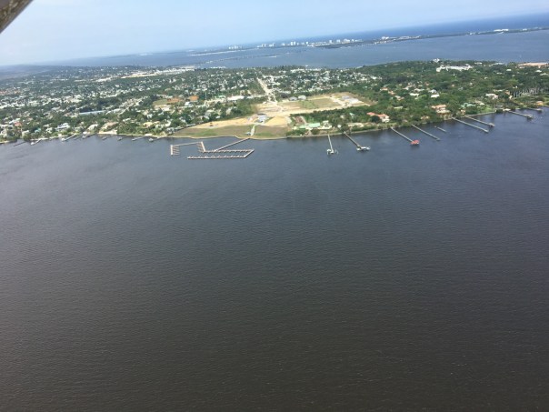


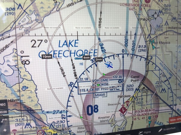


 Entrance to Caloosahatchee on west side of lake and near Clewiston Bloom is all through lake.


 Although this image below was not in the publication, I wanted to include it because one might drive by and not recognize this recently renovated, now officially registered historic structure in Rio for what it really is, ~a monument to the cross-state canal!


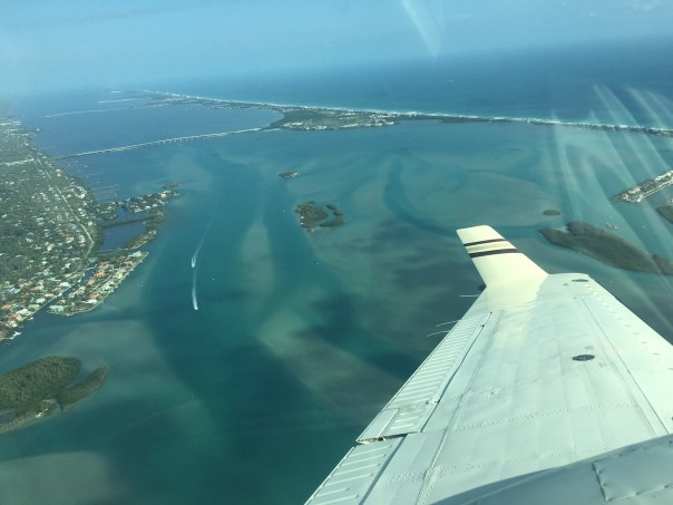


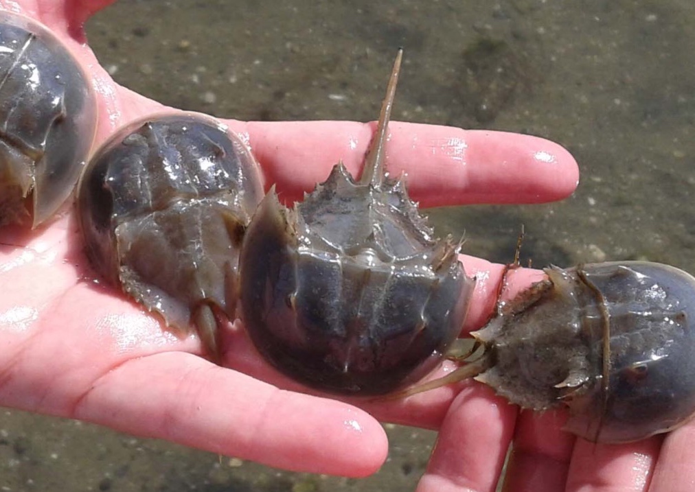


