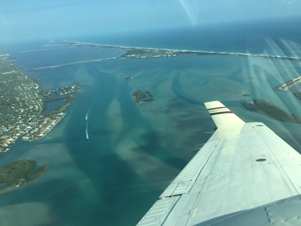
-L to R: The peninsula of Sewall’s Point lies between the SLR/IRL. The Sailfish Flats and Sandbar seagrass meadows lie between Sewall’s Point and Hutchinson Island. Witham Field, Stuart, can be seen west. The Atlantic Ocean is east. St Lucie Inlet State Park is located south on Jupiter Island. The St Lucie Inlet is cut between Hutchinson and Jupiter Islands. Today’s photos highlight the area’s returning seagrass meadows after their disappearance primarily because of years of damaging cyanobacteria laden Lake Okeechobee discharges, especially in 2013, 2016, & 2018. Photo Ed Lippisch, 8/26/22.When Ed came home from flying the RV on Friday, August 26, 2022, he said, “I think the aerials look good, you can really see the seagrasses.” I looked at him kind of funny. He never says anything like that. Looking on my phone, I could tell the photos were revealing, but it wasn’t until I viewed them full screen on my computer that I saw their true beauty. Ed’s photos reveal clear water, clear air, defined nearshore reefs, and lush seagrass/micro-algae meadows.
It is exciting to see and am I so glad Ed captured it! In the coming days and weeks tropical weather may be pushing our way. “Thank you Ed, for capturing the river before the height of hurricane season, before possibly more rains and more runoff.”
These just might be the most beautiful recent photos ever taken of the St Lucie River/Indian River Lagoon. Over the past couple of years, we’ve had some good ones of blue water alone, but blue waters cradling seagrass beds, the life of the sea itself, this is “true beauty.”
These improvements have only been possible due to recent ACOE policy decisions – no major Lake O discharges for over three and one half years, and Mother Nature, who so far, has not brought any of her discontent our way.
At this time, it is in order to thank former City of Stuart Mayor, Merritt Matheson, who went to great lengths over the past four years to hold accountable and build relationships with the Army Corps of Engineers. Mayor Matheson led numerous boat tours and meetings inviting, colonels, commanders, and staff. His St Lucie River tours led by an elected, passionate, educated, local helped the ACOE understand the fragility of our region and the intense ecological and health impacts caused by discharges from Lake Okeechobee. Mayor Matheson your efforts made a tremendous difference for the health of the St Lucie River. Thank you.
Ed and I went up in the Baron recently on October 30th, 2021 and it was a little bumpy. Although I have flown hundreds of times with Ed since the “Lost Summer” of 2013, when I decided I needed to overcome my fear of flying in small planes, sometimes this feeling, again, gets the best of me.
There may be a little turbulence or a vulture goes wizzing by the windshield and I think to myself: “This is it. This is the day. “
No matter how turbulent it gets, Ed always appears unaffected. He trusts the plane, the engineering, the physics of flight. Me? As much of a wonderful miracle as flying in a small plane can be, it always seems a bit, what shall I say, “unnatural.” Every time we land I cross myself thankful for one more flight. Ed always laughs.
What makes me go up again and again? Because every time we go up, it reinforces how much there is to fight for, what a beautiful place we live in along the St Lucie River/Indian River Lagoon. From the ground it is beautiful, from the air it’s something hard to describe. Some call this a relative of the overview effect.
I thought I’d share these St Lucie Inlet photos because they are impressive in their own right and also to compare them to what I posted yesterday on a flight from 10-27-21. As you can see light is everything. Appearances shift. On 10-30-21, around 11:00am it was overcast grey/green/blue over St Lucie Inlet Preserve State Park. It is also interesting to note the erosion on the south side of the St Lucie Inlet which was dug by hand as a permanent inlet in 1892 and created the St Lucie Estuary.
You’ll see that our German Shepard, Luna, was nothing but smiles! She reminds us we have so much to smile for!
-Ed’s selfie
-Luna is a very good flyer and never doubts the plane or pilot
-The air is great but there’s no place like home, Terra Firma!
-St Lucie Inlet to Atlantic looking beautiful at this time day. Note nearshore reefs.
-Crossroads’ confluence of St Lucie River and Indian River Lagoon, S. Sewall’s Point – note lack of lush seagrass meadows
Jupiter Inlet and Loxahatchee River– heavy rains causing discoloration
Beechcraft Baron, Ed Lippisch, August 21, 2021, 3:30pm
-Looking towards Stuart over Sewall’s Point, SLR/IRL. Sailfish Point Marina left corner.-Sailfish Flats- note shades of seagrasses but no lush meadows-brown coloration -Over Atlantic-Indian River Lagoon lies east of Sewall’s Point, St Lucie River lies west -Various views
-One can see river’s proximity to Witham Field in Stuart. These photos show darkness of St Lucie due to stormwater runoff off lands and canals C-23. C-24, and C-44. No Lake O discharges.
-St Lucie Inlet
-Stuart Sandbar with many boaters. Water is dark with stormwater and canal runoff but remains to recreational standards.
-West now over S-308, Port Mayaca, Lake O – no visible algae from altitude of 1500 feet. Satellite images do show algae on west and middle of lake. SEE my brother Todd’s website EYEONELAKEO for all info. -Although water looks good at St Luice Inlet at an incoming tide, the estuary is suffering from too much input. Read Florida Oceanographic’s update for details.
Today, August 22, 2021 Lake Okeechobee is at 14.39 feet. This recent TCPalm article by Ed Killer gives insights based on a recent media conference with Col. Kelly of the ACOE.
Thank you to pilots Scott Kuhns and Steve Schimming for providing a “wider perspective.” This morning, March 18th, their photos reveal an unravaged St Lucie River-Indian River Lagoon ~from 2500feet. These are shots I definitely could not get with my iPhone!
Thank you for the good news that shall be documented for all. ~The St Lucie, Indian River Lagoon -a year and a half into no Lake Okeechobee discharges- looks GREAT!
CROSSROADS ST LUCIE RIVER/INDIAN RIVER LAGOON, ST LUCIE INLET, MARTIN COUNTY, FL
SAILFISH POINT, HUTCHINSON ISALND
THE FAMOUS HOUSE OF REFUGE, BUILT IN 1876, HUTCHINSON ISLAND ocean and IRL
JUPITER NARROWS, INDIAN RIVER LAGOON SOUTH OF ST LUCIE INLET, ST LUCIE INLET STATE PARK
THE ST LUCIE RIVER-INDIAN RIVER LAGOON, COMING BACK, WHEN ALLOWED TO BE, IT IS “THE MOST BIO-DIVERSE ESTUARY IN NORTH AMERICA!”
My husband, Ed, took these photos of the Indian River Lagoon at the St Lucie Inlet on 2-28-18, just a few days ago. They are certainly beautiful enough to sell real estate…The turquoise water is so pretty one could easily overlook the sand desert below the surface waters.
Enjoy the blue water, but know that especially since 2013, our seagrass beds have been decimated by black sediment filled waters and toxic discharges from Lake Okeechobee. Seagrasses are the nursery for all sea life, especially the baby fish. These beds need time to reestablish if they ever will.
True beauty has something to offer, not just “surface water.” Keep your eye on the lake and fight against any coming releases this summer so we can get life back in our dear dead river.
These aerial photos over the St Lucie Inlet were taken by my husband, Ed Lippisch, Sunday, October 29, 2017, at 1:45pm.
The number one issue here is the polluted waters of Lake Okeechobee being forced into the SLR/IRL because they are blocked by the Everglades Agricultural Area from going south.
The ACOE has been discharging Lake O waters into the St Lucie since mid-September. These over-nutrified and sediment filled waters continue to destroy our economy and ecology on top of all the channelized agricultural and development waters of C-23, C-24 and C-25. Stormwater from our yards and streets also adds to this filthy cocktail.
Near shore reefs, sea grasses, oysters, fish? A human being? Better not have a cut on your hand…Not even a crab has an easy time living in this.
We move forward pushing the SFWMD and ACOE for the EAA Reservoir with these sad photos and the fact that our waters are putrid at the most beautiful time of year as motivation. We will prevail. One foot in front of the other.
Tarpon Fishing, Kent Hagerman 1893-1978. Courtesy, Sandra Henderson Thurlow.Fishing map of McCoy Bros. SLR/IRL date unknown, notice the extensive tarpon fishing grounds, Thurlow Archives.Tarpon on the line! Dave Preston
If we look into the mirror of history, we begin to see…
We begin to see how we destroyed one of the most famous and beloved inland fishing waters in North America and how we learned to do better. And if we are able, in time, not only to do better, but to return “health and glory” to the St Lucie River/Indian River Lagoon, it should be the tarpon, not the sailfish, that becomes our symbol, our king.
The first formal fishing club documented in Stuart was the 1916 St Lucie River Tarpon Club. The late 1800s and early 1900s were an era of great fame for the St Lucie River, build upon President Grover Cleveland and other presidents fishing trips to the area. Yes, the St Lucie was known as the “Fishing Grounds of Presidents.”
Ironically, at this same time, the Commercial Club, that evolved into today’s Chamber of Commerce, was promoting not just Stuart’s remarkable fishing, but also enthusiastically encouraging and awaiting the completion of the St Lucie Canal.
SFWMD canal and basin map. C-44 canal is the canal most southerly in the image.
“Once the muddy water flowed into the St Lucie River, they began to realize that the canal was not the blessing they envisioned,” writes Sandra Henderson Thurlow. Historian Alice Luckhardt more directly notes, “at one time tarpon were often caught in the St. Lucie River, but “disappeared” from those waters soon after the opening of the canal system to Lake Okeechobee in 1923.”
Ingeniously, and with more insight, in the years following the loss of tarpon and other river fish as seen in the McCoy map above, the ocean-going sailfish was marketed to replace the tarpon and become “the most prized fish of all…” as well as in time the symbol for both the city and county governments.
The magnificent Silver King? Just a dying memory, or no memory at all…
By the mid 1930s the Chamber of Commerce began publishing the “Stuart Fishing Guide.” In 1941 the largest sailfish run in Florida’s history occurred off the St Lucie Inlet. Remarkable! More than 5000 sailfish were caught in a 90 day period. “Thousands were slaughtered only to be dumped in the river, carted off by garbage collectors, and used for shark bait.” Stuart as the Sailfish Capital of the world was affirmed, but as my mother states, if “Stuart’s fame was to endure, so was the need for conservation of the species.”
The idea for conservation/protecting the industry had been in the works, the Sailfish Club had been talking about it and a few sailfish were returned to the ocean…. But after the sailfish run of “41, the idea of an organized conservation effort was solidified, and Sailfish Club of ’31 updated their charter in “41 “to further and promote sports fishing and conservation in the waters of the City of Stuart and Martin County.” Visiting sportsmen were awarded and inspired to work for the most coveted bronze, silver, and gold lapel pins based on the size of the sail they caught and released, not killed.
This is a great story, but what of the tarpon?
I can see his giant, ancient, dorsal fin rising from the waters of a healthier St Lucie River/Indian River Lagoon. For me, no fish will ever compare. As we restore our rivers, it is he who shall be KING! 🙂
Close up of solidarity fish on Florida’s Capitol steps, Clean Water/Amd. 1 Rally 2-17-15.) (JTL)
When looking through old ones you can find clues to Martin County’s historical ties with The Glades. Finding things in common is important as we work to improve relations, communications, and our waters.
My mother, historian, Sandra Henderson Thurlow, came across this ad, when looking in a 1921 Stuart City Directory. She writes: “The McCoy Brothers became rum-runners and owned what is now Sailfish Point. What is interesting to me is that in the 1920s, they were taking passengers and freight across the state through Lake Okeechobee via the West Palm Beach Canal.”
As we are learning from our Road Trip series, the West Palm Beach Canal was built in 1917 and intersects with Lake Okeechobee at Canal Point. What we might not know is that the McCoy’s Hutchinson Island land then known as “Coral Strand” became today’s Sailfish Point.
The brothers knew and loved the St Lucie Inlet area well enough to buy this land and establish their business there. The “Everglades Line” was probably one of many. Perhaps the brothers drank ice tea on their way from Sailfish Point down the Indian River Lagoon to Lake Worth’s entrance to the West Palm Beach Canal and through Lake Okeechobee? Although they were famous rum-runners, the most well-known brother, Bill, did not drink!
His obituary notes:
William Frederick McCoy (1877 – December 30, 1948): Bill McCoy was an American sea-captain and rum runner smuggler during the Prohibition in the United States. In running alcohol from the Bahamas to the Eastern Seaboard, he became world-famous as his merchandise was uncut and clean. Thus the saying the “Real McCoy.” McCoy himself never touched liquor and was considered an “honest law-breaker.” He also took pride in the fact that he never paid organized crime, politicians, or law enforcement for protection.
I think we can consider Bill McCoy a Glades/Martin County honest law-breaker common ancestor. “The Real McCoy” a symbol and foundation for building better relations from the Coast to the Glades?
I don’t know about you, but I can’t think of a better place to start. 🙂
Map of Canals 1924 Florida Archives.1950 map by Ben McCoy of the “Coral Strand” and its riches, today known as Sailfish Point.South Hutchinson Island aerial showing mosquito ditches through mangroves and other vegetation. 1952 courtesy of Thurlow Archives.Google map showing Hutchinson Island with Sailfish Point south next to St Lucie Inlet. East is Atlantic Ocean and west is the Indian River Lagoon and Sewall’s Point.Lake Okeechobee.
Today I am sharing a “gallery” of discharge photographs from my husband Ed’s flight over Ft Pierce, Sebastian, and Stuart’s St Lucie Inlets. The photos were taken yesterday, March 6th, 2016, around 2pm.
A picture speaks a thousands words…(In this case through about 106 frames.) Yesterday was an absolutely beautiful day, yet area waters estuarine and ocean were not necessarily so. —-Certainly not those surrounding the St Lucie River/Indian River Lagoon near the St Lucie Inlet.
The discharge levels and reports for Lake Okeechobee can be reviewed at the Army Corp of Engineer’s Jacksonville website here: http://w3.saj.usace.army.mil/h2o/reports.htm. Lake Okeechobee is reported at 15.68.
The ACOE will be releasing less according to a recent press release.
Ft Pierce, Sebastian, and Stuart’s St Lucie Inlet, 3-6-16, Ed Lippisch
Tiger shark at the commercial plant in Port Salerno, ca 1930s/1940s. (Photo courtesy of Sandra Henderson Thurlow)Port Salerno fishing village’s shark factory ca. 1930s and 40s. (Photo courtesy of Stuart Heritage Collection and Alice Luckhardt.)
Sharks seem to be feared more than they are respected….but that perception is changing as their endangered status becomes more critical and well-known. As most things that have to do with natural resources and the environment, there were few concerns regarding the “overfishing of sharks” in Florida the 1930s and 40s. Their supply seemed endless, and their value to the oceans and ecosystem was not widely understood.
This photo of a shark from my mother’s historic archives, represents one of the 25,000 sharks that were caught and processed in Port Salerno each year on average off our St Lucie Inlet during the 1930s and 40s. Port Salerno was a tiny fishing village. Today it is one of the hippest up and coming areas of Martin County. The shark plant is no longer there. A museum created in memory of such would be a great addition to the area…
During the 1930s, sharks provided important resources to society and gave fishing families a stable income. During World War II vitamin A was a hot item, especially for pilots pursuing accurate night vision during their dangerous missions.
Another interesting forgotten historical fact?….believe it or not, “by mistake” the first “shark repellent” was tested and created right here by local fishermen—yes–right off the St Lucie Inlet off our St Lucie River/Indian River Lagoon. It was “top-secret” and it worked!
Today I will feature a vignette of family friend, historian, and Miami native, Alice Luckhardt. Her very informative and comprehensive text is about Port Salerno’s shark fishing history. Alice and her husband, Greg, have written hundreds of historical accounts that are shared in the Stuart News and are also part of the public archives of Martin County’s Stuart Heritage. Thank you Alice for these important historical resources!
The sharks? Good luck to the remaining; “may you be fruitful and multiply….”
A Save Our Sharks Protect and Respect drawing by a JD Parker Elementary student, 2015 as part of the River Kidz in our schools program. (Photo JTL)Historian Alcie Luckhardt. (Facebook photo 2015)“Old Stuart,” The big city! Salerno would have been much less developed and smaller than this south by about 10 miles.Shark Industry, Port Salerno. The livers were used for vitamin A production. (Photo courtesy of Sandra Henderson Thurlow)
Historical Vignettes of Martin County: Salerno Shark Industries and Vitamin A by historian ALICE LUCKHARDT
STUART – Vitamin A, essential for good human health was once derived from oil extracted from the liver of sharks and a leading supplier of this valuable substance was the tiny fishing village of Salerno.
Shark liver oil was believed to promote wound healing, stimulate growth, increase resistance to infection, aid in combating fever and colds, improve eyesight, prevent excessive dryness of the skin as well as an overall general remedy for conditions of the respiratory tract and the digestive system.
Generally, the livers, chopped into fist-sized chunks, were rendered down in big vats. The oil could be skimmed off, cooled and canned, ready for shipment.
In the 1930s, assisted by brother George, Captain Charles L. Mooney’s Salerno Shark Industries-Fisheries, Inc., supplied not only the needed shark liver oil and novelty shark teeth for jewelry, but also the outer skin hide of the sharks. In 1938, an order was placed by a Chicago firm for 200,000 shark teeth. The Ocean Leather Corporation processed the skins into leather goods, primarily luggage. Fins, considered a delicacy by some, were shipped to China.
From its meager beginning, Mooney had continued to make improvements in the business, increasing boats, buildings and processing methods.
By 1941, a shark meal plant, measuring 36 x 65 feet and equipped with hammer mills, drying machines and conveyors, enabled the profitable use of all of the shark’s carcass, accommodating about 200 pounds an hour.
An aroma filled the air as the cooker, steam boiler, hammer mill, flaker dehydrator and sacker completely finished the process, ready for shipment, the ‘meal’ eventually to become food for dogs, cats and poultry. To supply these industries, thousands of sharks were caught in the Gulf Stream and elsewhere, sometimes as many as 600 in a single week.
Scientific analysis and studies were conducted to determine the best use for shark products.
In the 1940s, Robert M. French, Sr., who had founded the Shark Fisheries of Hialeah, Florida, headed the Salerno site, joined later by his sons Robert Jr. and Price, Mooney having previously relinquished his interest due to ill health.
In 1944, the Shark Fishery was purchased by the Borden Co., one of the largest users of Vitamin A in the US, retaining R. M. French Sr. as chief executive. Borden’s primary interest was to increase vitamin production, from shark liver oil, to fortify and enrich its milk products.
The liver, being a main source of Vitamin A, was considered of utmost importance in the war effort, with supplies from world markets having been cut off. The vitamin was important not only for the health of the soldiers, but especially for night fliers who took the vitamin before take-off to see better in the dark.
Actually, during those years, a very secretive study was also being made which involved the Salerno fishery, the details of which were known by only about three or four people in the area.
Although sharks will sometimes attack and eat other living or freshly killed sharks, it was noticed by the fishermen that hooks which had been baited with cut-up pieces of the flesh from sharks caught the day before, were virtually left untouched and that, furthermore, the sharks actually avoided the area, not returning for days.
With that information, the US Federal Government under the Office of Strategic Services, employed Stewart Springer, from Homestead, Florida, a chemist, to work with the Salerno plant to further investigate and conduct experiments, the end results being the development of a shark repellant.
Known as ‘Shark Chaser,’ it proved to be invaluable in saving the lives of sailors or aviators forced down at sea in shark-infested waters. According to Robert and Price French, interviewed later, it was difficult to have to pretend “nothing unusual was going on” as the experiments involved the cooking of thousands of pounds of shark meat in barrels of an alcohol solution, the aroma definitely attracting some attention.
By 1946, the shark fishery plant, one of only three of its kind in the U.S. was considered essential to public welfare and continued to supply shark liver oil and other products. Borden expanded and improved the facility which at its height employed as many as 50 people and used 12 boats to haul in the ‘tigers of the sea’ some 25,000 or more per year, with an annual gross of about $500,000.
However, by 1947, due to scientific research, Vitamin A could be synthesized and was therefore much less expensive. In time, the man-made vitamin supplanted the natural one obtained from the shark and by July 1950, the Borden Corp. business in Salerno was closed.
In June 1962, the Shark Industries factory was burned to the ground by the Port Salerno Volunteer Fire Department as a fire practice drill. The remains of an industry which had gained national attention, recognition and perhaps gratitude, was gone. With some imagination, those in Salerno may sense that distinct aroma still lingering in the air.
Alice L. Luckhardt is a freelance historical researcher and writer and member of the Board of Directors for the Stuart Heritage Museum and researcher for the Elliott and House of Refuge.
The seawall at Sailfish Point’s Dunes Condominium is right next to the ocean. St Lucie Inlet lies beyond this point by about a quarter-mile. 7-26-15. (Photo Ed Lippisch)
Yesterday afternoon, Ed and I had hoped to walk our dogs, Bo and Baron, to the St Lucie Inlet, but were cut off by an incoming tide and a Sailfish Point’s seawall. Having grown up in Martin County, it is amazing to see such changes “right before my 50-year-old eyes…”
Of course when I was a kid there was no Sailfish Point development, no seawall, no apparent sea level rise, just the beach sun-flowered sand dunes and Bathtub Beach changing daily to the winds of time with the remnants of James Rand’s “Seminole Shores” development crumbling…
Today Sailfish Point is here. Its 625 homes are some of the most exclusive in the county. Built in the 1980’s it was developed by Mobile Oil Corporation. The area brings tremendous tax revenue to everyone and to every school in Martin County…if it washed into the sea there would be issues for all.
Sailfish Point: (http://www.sailfishpoint.com/martin-county/)
It must be noted that the St Lucie Inlet itself is responsible for some of this erosion…the inlet was opened permanently in 1892 by pioneers led by Captain Henry Sewall of Sewall’s Point. Naturally the inlet would open and close with tides and time. Opening the inlet permanently now defines our county, and we would not give it up; but as all things in life: there are both positives and negatives to every action.
Today the waters of the ocean are encroaching….and time seems to be speeding up.
Building on barrier islands is not particularly long-term in that barrier islands are meant by nature to turn over on themselves like a conveyor belt. On the other hand, I have been to the Breakers Hotel in Palm Beach and their seawall is right up to the historic hotel and has been for years….We stave off the ocean as long as we can. Much of Florida east coast is built on barrier islands…
What does the Bible say? “The wise man built his house upon a rock…”
Anyway….today I wanted to share Ed and my walk as it is symbolic of our times.
Google map showing Hutchinson Island showing St Lucie Inlet. Sailfish Point immediately north of inlet. East is Atlantic Ocean and west is the Indian River Lagoon and Sewall’s Point and St Lucie River.
Other than the surreal seawall and encroaching sea….there were many sea turtle nests, marked by the Fish and Wildlife Commission. Many turtles had laid their eggs right up against the seawall! Many of them! I counted at least 50 just in our short walk. Good for the turtles but it seems many nest are doomed to wash away… For thousands of years these turtles have returned to the beaches of their birth to lay eggs. Now many of them literally come up “against a wall.”
Turtle nest right up the seawall at Sailfish Point. 7-26-15.(Photo JTL)Turtle nest close to SP’s seawall. (JTL)Sea turtle nest. (JTL)
I must mention that the people of Sailfish Point are also “up against a wall,” as they have to worry about their homes falling into the sea….Here one sees a sea wall repair taking place. I don’t think the sea wall is that old in the first place.
Home at Sailfish Point undergoing seawall repair. 7-26-15. (Photo JTL)Ed looks inside sea wall being repaired. (Photo JTL)
The most intense erosion seems to be the north area of Sailfish Point, closest to Bathtub Beach….and it is summer. This should be the time the ocean, sands and tides are most forgiving. Winter waves are much more brutal, unless there is a hurricane of course….
The other interesting anomaly Ed, Bo, and Baron and I experienced was the hundreds of sea hare mollusks that had washed up on shore. Ed Killer of TC Palm just wrote a great piece on these interesting, harmless creatures that scientists believe are washing ashore due to cold water upswells and algae shifts in the ocean–their swimming affected, they slow down and are carried to shore by the waves fated to dry out in the sun.
As Ed and I walked back I picked up as many as I could and threw them back into the ocean knowing that really I was only “buying them some time.” Chances are they will wash right back up on the shore. In the end, nature always wins. In time, we like the sea hares, will find this out , but until then it’s a great walk on the beach, isn’t it?
One of hundreds of sea hare mollusks that had washed ashore near Sailfish Point 7-26-15. (Photo Ed Lippisch)
Ed stands with Bo and Baron in front of the seawall at Sailfish Point looking towards the sea….(Photo JTL)
Playing fetch with Bo and Baron, (Photo JTL)Jacqui and Ed, near Bathtub Beach, Stuart, Florida. 2015. We had fun even though the beach is not what it used to be….
THIS ADDITION CAME IN FROM MY BROTHER TODD: AMAZING!
Jacqui–
Interesting blog post!
In the meantime I thought I would respond to your post with a rough video of Sailfish Point while eating my lunch…..
(https://youtu.be/TW8URTQG2o0)
It is a movie of the following:
1. 1935 NOAA Chart – note the jetty already in place
2. 1940 Aerial
3. 1952 Aerial
4. 1968 Aerial – quick. I should have skipped it.
5. 1970 Aerial – note the old “Empire of the Ants” pier and the strange water slick to the south.
6. 1981 Aerial – showing the construction of Sailfish Point.
Look at these two screenshots of the beach just a few months apart late last year—-Todd Thurlow
Google image seawall is covered 8-12-14.Google image seawall is uncovered 12-2-14.
It is human nature to “miss something once it’s gone.” This is true whether it’s the St Lucie River/Indian River Lagoon, or something else.
Such was the case for me this weekend and I tried to prepare for the “miss.” My husband’s red and white Cessna 340 is being sold. Knowing the plane would available no more, I arranged a date yesterday for videographer and River Warrior, Kenny Hinkle to fly in the plane. I had been wanting to do this for a long time, but as is so often the case, “never got a round tuit.”
Kenny and Mike Connor’s big win with their video of the toxic algae bloom at S-308 last Friday at Lake Okeechobee causing Senator Joe Negron to immediately call Army Corp of Engineers Col. Dodd, who then stopped the discharges was a big win! Thank you to all involved. Reeling from this positive occurrence, I thought I would like to help Kenny get some more footage for his “next big win.” The 340 is the perfect “vehicle” for that…
The plane provides a great “overview” flying 1500 feet or much higher, and can cover long distances quickly.
Thank you to my husband for providing this trip, this farewell…In fact thank you to my husband for all of this. If it were not for him, the river would not be documented as it is!
It was actually this plane, the Cessna 340, that took the first photo on June 28th of 2013, during the toxic Lost Summer, that inspired me to start taking photos of the river and discharges regularly. As you can see below, this photo was/is so alarming, showing the impact and damage caused to property values and the environment by the releases from area canals and by Lake Okeechobee. Lake Okeechobee always the nail in the coffin….
Cessna 340 June 28th 2013 photo showing plume from area canals and Lake Okeechobee exiting St Lucie Inlet.Hand drawn map of flight path over option land map. 2015, JTL.
So today, I am going to provide the farewell videos I took, and one other You Tube video I finally published so that if you ever want to, you can see for yourself what it looks like to fly from Stuart over the St Lucie River and C-44 canal, around the south rim of the “ocean of water” known as Lake Okeechobee, and then along the lake’s rim passing areas/cities of Pahokee, Bell Glade, and South Bay, then turning south along the New River Canal, flying through the sugarcane fields, (the Everglades Agricultural Area), until finally seeing the water conservation area/s, and Alligator Alley (even though I think I mistakenly say Tamiami Trial in the video….) and then flying back up the Miami canal to Clewiston before I stopped filming due to turbulence.
The videos are raw footage. Nothing fancy, the reality of a low plane ride. Many try to convince me to make them more professional. I like them as they are. Real. They show the view, the conversations, the thoughts, the heat, the noise, the turbulence….the miracle of being above ground!
The videos are split into 5 parts covering most of the trip and I included one other at the end that was taken in 2014 by Ed with a Go-Pro as it shows clearly the US Sugar option lands that are now being so hotly debated for Everglades restoration and purchase with Amendment 1 monies.
To use another cliché, “seeing is believing.” Yes, see, believe, and know, that we are changing our world.
Just recently, my husband Ed and I had the hardwood floors of our 1977 home redone. During this time, we literally “moved out” into one room of the house for almost four weeks. As much as this turned my world upside-down, it forced me to go through all of the “stuff” I have acquired over the past ten years in my St Lucie River/Indian River Lagoon files. I found some cool things I had forgotten about.
The folder I am sharing today is entitled OLD INLET PHOTOS. It includes aerial photos of the Jupiter, Stuart (St Lucie), Ft Pierce, and Sebastian inlets. I borrowed the photos from my mother, historian Sandra Henderson Thurlow, years ago. My photos are copies of the originals. I believe she and my father acquired the photos through Aurthur Ruhnke’s Photography Shop that once was located in Downtown, Stuart.
Written on the back of all photos except the Sebastian Inlet, was the year “1936.” The photographer was R.B. Holt. The Sebastian Inlet however, has “1962” written on the back of the photo along with “Sterling Hawk’s name,” a different photographer.
I love old stuff like this; I hope you do too.
Enjoy and dream of a time long ago…the fishing must have been great, and look how undeveloped the surrounding lands were! The inlets helped promote the development of the Treasure Coast Region.
Of course before man created the inlets permanently along the Indian River Lagoon, Mother Nature’s winds and tides would decide if an inlet was open or closed to the sea. Over thousands of years, inlets opened and closed all along the Indian River Lagoon making the naturally fresh waters brackish for a time and allowing wildlife to flourish in these areas.
Man was attracted to these natural inlets as well. I was just reading last night about how the inlet at Jupiter closed in the 1860s when the US government was building the Jupiter Lighthouse. Nature’s closing of the inlet was a “great inconvenience.” Today we would also consider it a great inconvenience to have any of our inlets closed.
The problem is that they are not meant to be permanently open and erosion problems occur over time. As most things in life, there is a positive and a negative; the tricky part is figuring our just where to draw the line in the sand…
Jupiter Inlet, 1936. (All aerials from the Rhunke Collection, R.B. Holt is believed to be the photographer for all but Sebastian Inlet photo, Thurlow archives.)Jupiter Inlet, March 18, 1936.Stuart (St Lucie) Inlet, 1936.Ft Pierce Inlet, 1936.Ft Pierce Inlet, 1936.Ft Pierce Inlet, 1936.Sebastian Inlet, 1962. Photo by Sterling Hawk.
_____________________________________________
All photos courtesy of Sandra Henderson Thurlow, historian. Her books on Sewall’ Point, Stuart, Jensen and the House of Refuge can be purchased at both the Stuart Heritage Museum, (http://www.stuartheritagemuseum.com) and at the Elliott Museum, (http://www.elliottmuseumfl.org).
Only a thin ribbon of land separates the Atlantic Ocean from the Indian River Lagoon…. (Photo Jacqui Thurlow-Lippisch and Ed Lippisch, 2014.)
As we all know, estuaries are the nurseries of our oceans. Sometimes we think of rivers and oceans as separate, but they are connected and the destruction brought upon one affects the other.
Looking above at this photograph of Hutchinson Island near the House of Refuge one can see how close the Indian River Lagoon estuary and the Atlantic Ocean really are. Not only that, when polluted water flows out of the St Lucie Inlet from the St Lucie River estuary, it covers and negatively affects our “protected” near shore reefs and the tremendous variety of life there.
A photo from Martin County shows polluted runoff flowing over nearshore reefs along Jupiter island south of Hutchinson Island and the St Lucie Inlet, 2011.
According to the Consortium for Ocean Leadership (http://oceanleadership.org) of which locally FAU/Harbor Branch is a member:
“Ocean ecosystems have been subjected to decades of intense fishing, urban and agricultural runoff, and the loss and degradation of estuaries and wetlands. Furthermore, changes in ocean temperatures, salinity, currents and acidity are having significant impacts on marine living resources. The incidence of hypoxia, as in the Gulf of Mexico (http://www.ncddc.noaa.gov/hypoxia/) (dead zones) has increased almost 30 fold in the United States since 1960 with more than 300 systems recently experiencing hypoxia.”
As we all know, the entire St Lucie/Indian River Lagoon is often a “dead zone,” due to toxic algae blooms caused by too much polluted fresh water runoff from canals carrying nitrogen, phosphorus and other pollutants from agricultural canals along the lagoon, and Lake Okeechobee .
The recommendation of the Consortium is as follows:
“…support conservation programs and services to reduce runoff of nitrogen and phosphorus, and sediment from agricultural activities which is causing harmful algae blooms and dead zones.”
Think about this for a minute.
The four agricultural canals we have here in Martin and St Lucie Counties: C-44, C-23, C-24, and C-25 have no filtering system. When it rains, the water falling on thousands and thousands of acres of agricultural as well as urban lands picks up fertilizer, pesticides, herbicides, oil, cow, horse, and pet waste, leaky septic tank effluent, and what ever else is out there; this water then runs into the canals that in turn are released directly into our waterways. When Lake Okeechobee is dumped it too has no filtering process, so not only do we get our pollution but we get “Orlando’s” as well as the Everglades Agricultural Area south of Lake O. forces the lake water to flow east and west rather than south as nature intended…. Is it any wonder why we are a toxic mess?
Canal and basin map SLR/IRL. (Public)
It must be noted that Martin County, the state, and federal government for years have been working on the IRL South Project that is part of CERP. (http://www.evergladesplan.org/pm/projects/proj_07_irl_south.aspx) This project would help hold, filter, and clean polluted water for canals C-23, C-24, and C-25 before it enters the St Lucie River/Indian River Lagoon. These projects are so expensive and political they are a “slow moving slug,”but they are moving.
Clean water does not come easy. The public must push and push. There is fierce competition.
Yes, we the public must learn more about these projects and how to help get these projects funded, along with our fight for a flow way south of Lake Okeechobee.
The government will only move forward with these projects if they know the public is expecting it and helping with it. With Amendment 1’s passage the possibility is even more of a reality, but it is no guarantee. We must advocate.
The line between the estuary and the oceans is very thin, as is the line between the people and their government. Get involved! The river and the ocean both need you!
St Lucie River sunset photo, oak hammock, Sewall’s Point, 2008. (Photo by Jacqui Thurlow-Lippisch.)
History is a window, a window into understanding why and where we are today. The Town of Sewall’s Point along the St Lucie River/Indian River Lagoon has some of the most wonderful historical descriptions of its original beauty, and I believe that is why we try so hard as a town to keep remnants of that historic beauty today.
The town is a “Tree City;” a bird sanctuary; and there are very strict fines for cutting down trees with over a two inch across trunk. Development rules are supposed to be protective of wooded uplands and wetlands, sometimes this does not seem to be the case.
Nevertheless, today I will quote from a “Description of Indian River County,” as it was called, from a Maine Journal , The East Coast Advocate, April 24, 1891 by Rufus King Sewall. This document was transcribed by my mother, historian Sandra Henderson Thurlow in 2009.
Here we go and remember 1891 was the year before the St Lucie Inlet was opened permanently so the river waters were fresher..
_____________________________
“At the Indian River Hotel, Titusville, we lodged for the night and were lulled with the song of two mosquitoes…at 5 a.m. the Indian River steamers called for embarkation south-bound and all aboard, most comfortable quarters in neat staterooms, spacious saloon and good service are found… The banks of the Indian River are general sops-wood, of cabbage palm, pine and cactus—uncleared because used as a screen against the fierce east winds which whip the orange and banana to death…Fine oysters, big trout, mullet, pompano, with channel bass abound…
The climate is the great charm of travel in the region. Within an hour of Titusville, the heavy, hot depressing , suffocating atmosphere of the interior of Florida suddenly changes to soft exhilarating, and cool refreshing inhalations, which the lungs expand to draw in with gateful sensation.
Cover of book “Sewall’s Point,” Sandra Henderson Thurlow. Sewall’s Point Post Office late 1800s.
It was 2 a.m. when the whistles sounded for San Lucie Landing at Sewall’s Point starting to wing acres of and acres of sleeping ducks whirring, splashing and diving, in dismay, before the lights of the rushing steamer and we rested on shore, while the St Sebastian turned toward Jupiter below. The river scene and surroundings were enchanting , sea and shore burnished with tinted rays of a sunrise and indescribably grand and novel. The ducks had grouped in shoals on their feeding grounds.
Fish were leaping in the light and the hum of her life stirred the evergreen prospective with a marked absence of bird song. In the east across the sound tree miles away, over Gilbert’s Bar, the broad ocean stretched beyond sight, the pathway of big ships southward bound clear to the naked eye. In front, Mangrove Islands bounded the horizon whose channel fretted the outgoing tides of Jupiter Narrows. Northward and west the broad reaches and pitch-pine plains of the deep and wide San Lucia shut off vision.
Underfoot and around the rock-bound bluff of the Peninsula of Sewall’s point in gorgeous green and gold, of satin-wood, oak, palmetto and rubber forest trees dazed the eye.
All strange and primitive with novel tropical surroundings out of reach the peninsula separating the Indian and San Lucie waters is a rockbound elevated ridge with bluff frontage on San Lucie shores in L. N. 27 degrees 15 min.
It is crowned with tall grown palmettos with tufted tops of palm leaves, naked branchless stems like the mast of a ship.
The water is pure and good…The largest trout I ever saw abound and shoals of mullet.
Sharks and alligators abound in the waters, and turkeys, bear and deer on shore in their season. In the creek opposite Point Manatee the fishermen linger with nets and gun to catch the sea-cow as they feed along the shore….”
The airs and winds are soft and balmy expect the northwest, refreshing, grateful to the lungs with wonderful healing properties and purifying effect exciting to outdoor activity and stimulating to vital forces…The entire atmosphere environment pregnant with healing…
_____________________
Interesting. Like poetry but for me “disturbing” as it talked about people hunting manatees. This at least highlights how we have changed historically, as manatee are protected today.
Sewall’s Point, photo by Ed Lippisch, 2011.
I hope you enjoyed that reading….
It was a beautiful world, there for the taking and we have taken it. For better or for worse we have. Let’s remember our history and that no matter what this place, this St Lucie River/Indian River Lagoon is today, it has always been “a place of beauty.”
May we revive her waters and her shores in respect to that which created this sacred place, and for those who have loved and documented her before us. Thank you Rufus King Sewall.
The St Lucie River basin/drainage map 2013, SFWMD.
For thousands of years, before the intervention of modern man, the Ais Indians walked the banks of a large fresh water “stream,” that flowed to the Indian River Lagoon. When the Seminoles came years later, they called it Halipatiokee, Alligator Water, as it was fresh and full of gators. The Spaniards came in the 1500s, on and off for centuries. They first called the river, Rio de Santa Cruz, river of the Holy Cross, as the river is cross-like. Later, they re-christened the river Rio De Luz , river of light, for the lighting on the water is heavenly. Eventually, the Spanish called the river, Santa Lucea. The English then taking over, “anglicized” the name Santa Lucea, to what we know today, as “St Lucie,” the church’s saint of the blind, and of “vision.”
1883 Geodetic Survey, Indian River Florida, St Lucie River.
Unfortunately, there was not much long-term vision when the watersheds around the St Lucie were altered by modern man. In 1892 area pioneers cut a permanent inlet from the St Lucie River/Indian River Lagoon to the Atlantic Ocean, killing the native fresh water grasses that supported an entire ecosystem. Nonetheless, they created something wonderful, the brackish estuary we all know today. This area, over the years, before its recent destruction, became one of the most bio diverse estuaries in North America.
That wasn’t enough, the local people and the state, with the help of the federal government’s Army Corp of Engineers, decided they wanted a connection to Lake Okeechobee for trade, travel, agriculture and the convenience of keeping the big lake of Okeechobee, “low.” So they built the C-44 canal connecting Lake Okeechobee to to the St Lucie “River.” In high water times, the overflow from the lake was directed into the St Lucie River as it is today. Later, around the late 1950s the people decided they wanted more drained land for orange groves and development in the north, and less flooding, so they got the state and federal government to build the C-23, C-24 canals in Martin and St Lucie counties, draining some areas that had never flown south before. These canals even drained lands out west, in what is now Okeechobee County, and in the north, known today as the City of Port St Lucie.
Did the people building these canals ever think about the effects on the Saint Lucie River? This seems doubtful. And so today, we have a river system that takes on much more water than it was ever meant to receive.
As Ernie Lyons, the former great environmentalist and editor of the Stuart News wrote in the 1960s about the loss of the headwaters of the South Fork of the St Lucie River during his lifetime:
“…The drainers got to work on the marshes. The cypress bordered ponds became white sand in the dry times. A ditch through them gushed silted floods during the heavy rains. The little stream was ruined. It turned from paradise to paradise lost…”
Not until really the 1970s did humankind start to reflect and realize that we literally were killling paradise, and we have been trying to revive the spirit of the St Lucie River/Indian River Lagoon ever since.
With out a doubt, the spirit of the saint still lives in the St Lucie River; her ancient story is that she lost her eyes to give the people their own “to see .” When you drive over the bridge and look at her, the beautiful St Lucie, open your eyes and ask her to give us all, “better vision.”
Portion of 1911 Sewall’s Point Land Company map showing area off of Sewall’s Point and Stuart where the great “Port of Stuart” was being developed.
The headlines of the South Florida Developer on December 29th, 1925 bragged about a Stuart along the St Lucie/Indian River Lagoon very different than the one we know today:
“Port of Stuart, Florida’s New Gateway. “
“The Opening of the St Lucie Inlet to the commerce of the world will bring to Stuart and all Martin County that belated recognition to which it is rightfully entitled by virtue of its strategic geographic location.”
“W.B. Shearer, recognized international authority on ports and waterways, makes the positive statement that of all the East Coast’s four hundred miles of waterfront, the harbor at Stuart is the the only port with natural advantages suitable for a naval base…”
“St Lucie Ship Canal Locks- the first link in the chain of waterways that will eventually form a navigable canal from the Atlantic to the Gulf of Mexico is the “St Lucie Ship Canal” now 95% complete. It’s completion will open up the fertile western portion of Marin County…”
As these headlines show, the “Port of Stuart” was not just a dream, in the early 1920s, it was a becoming reality. Details of the port still exists in dusty federal, state and local documents. If it were not for the Great Depression of the late 1920s and the difficulty for the ACOE in dynamiting the Anastasia rock from the bottom of the St Lucie Inlet, it could have been a reality.
So how could this be? Today an idea like this would be heresy!
Well, Captain Henry Sewall, for which the peninsula of Sewall’s Point is named, was one of many responsible for this “heresy.” Not only had he led locals to open the St Lucie Inlet by hand in 1892, he had served as county commissioner, and state representative.
In 1910 Captain Sewall and his powerful business friends, including adventurer Hugh Willoughby, founded “Sewall’s Point Land Company,” as Captain Sewall had inherited the tip of Sewall’s Point and large portions of waterfront and other lands along Stuart through his family linage to the famous Miles-Hanson Grant.
According to Sandra Thurlow’s book: “Sewall’s Point, the History of a Peninsula on Florida’s Treasure Coast,” after the formation of Sewall’s Point Land Company, the men got right to work building the Sunrise Inn on Old St Lucie Boulvard, and miles of roads in today’s Golden Gate; (see map above), government, bonds were held by the county and a turning basin at the tip of Sewall’s Point was dredged; this fill created today’s Sandsprit Park.”
A turning basin at Sewall’s Point? You’ve got to be kidding.
They were not.
Even poetry was written for the dream, ironically by beloved environmentalist, Ernie Lyon’s father:
Just One Place for the Harbor by Harry Lyons 1924
“Brave sailors in Atlantic storms, A harbor need for aid. They skirt the coast of Florida, Lest commerce be delayed. When hurricanes sweep o’er the deep, And ships grave perils face, ‘Tis the duty of all mariners, To seek an anchorage place. You’ll find the place for a harbor here, Where the old St. Lucie flows. There is room for ships at Sewall’s Point, Where the Indian River goes. No where else is there such an inlet, Down below or up above. There is just one place for the harbor! Stuart the town we love! From Stuart to Fort Myers at last, We’ll have a waterway, When the canal is finished, And they’re hastening the day. Across Lake Okeechobee, From the Gulf of Mexico, Oil and phosphate, fruit and lumber, Into Stuart soon will go.”
Sewall died in 1925 and the bottom fell out of the real estate market around 1926. Around the same time, two devastating hurricanes put the nail in coffin of the Stuart Port at the St Lucie River and Indian River Lagoon.
It is interesting to note that the St Lucie Canal, C-44, between Lake Okeechobee and the St Lucie River was completed not only for transportation and trade, but for flood control of agriculture and people working south of the lake. The prosperity associated with the canal for the local people of Stuart never came and the canal ended up being a major factor in the destruction of their beloved waterways…
Well time goes on, new dreams come and go; new fortunes are made and lost. But for old times’ sake, one can stand at Sandsprit Park, and look out to Sewall’s Point remembering perhaps Stuart’s biggest dream, the lost dream, and for many, a dream well lost, the dream of the “Great Port of Stuart.”
*Thank you to my mother, Sandra Henderson Thurlow, for sharing her historic articles to make this write up possible.
Homes and Condos at Sailfish Point compromised by beach erosion-with newly constructed seawall and birm, 2-22-14. (Photo JTL)
The trucks come in about once a year and dump millions of dollars worth of tax payer sand on Martin County beaches and other’s throughout our state. Then winter’s storms arrive and wash it back into the ocean, covering and damaging our nearshore reefs. But at least the turtles have a place to lay their eggs…?
Erosion is a natural part of all coastal barrier islands, in fact, time lapse photography would show these islands moving, like giant sea slugs, changing shape, due to erosion and accretion, over time.
Before modern man settled this area, inlets along the Indian River Lagoon came and went with the whims of Mother Nature. Looking at old maps, one sees documentation of changing natural inlets over time. Jupiter and Indian River Inlet north of Ft Pierce were the only long standing opening to the sea in our area most recently. Over thousands of years, others came and went, all along the lagoon. Peck’s Lake in Martin County broke through as recently as 1960 and was quickly “closed…”
In 1892 in today’s Martin County, then Dade, Captain Henry Sewall’s inspired local men to dig a permanent inlet, by hand. My historian mother has told me stories of other inlet attempts as well. According to her, one time, the men fell asleep after the exhausting dig, only to awake and find the tide coming in, filling in their work! One local’s pet raccoon was tied to a tree and taken away by the strong waters. Even today, Mother Nature want’s to fill back in the St Lucie Inlet, but we continue to resist her.
Very interesting is that “old maps” also show Jupiter Island on equal “terms” with Sailfish Point. But today Jupiter Island is much “further back” as she has eroded over time and been slowly swept into the sea. This remains an problem of enormous proportions today that is on the verge of law suit. Last year, the Army Corp of Engineers informed Martin County they wish to take the lovely textured, offshore sands of Stuart, to re-nourish, Dade and Broward Counties beaches. Unbelievable…
The inlets give us access to the ocean, they raise the value of our property, they were and could be again national defense. Most timely for today, in the case of the St Lucie Inlet, it allows the putrid waters slugging forth during rainy season from C-23; C-24 ; C-44; and worst of all from Lake Okeechobee, to go to sea.
There are those who believe we should let the inlet close up; and there are many who believe we should fill in the canals; there are those who believe the inlet is what defines Martin County and we should do everything to keep her open. Hmm…
One thing for sure, fighting Mother Nature is a full time job.
 When Ed came home from flying the RV on Friday, August 26, 2022, he said, “I think the aerials look good, you can really see the seagrasses.” I looked at him kind of funny. He never says anything like that. Looking on my phone, I could tell the photos were revealing, but it wasn’t until I viewed them full screen on my computer that I saw their true beauty. Ed’s photos reveal clear water, clear air, defined nearshore reefs, and lush seagrass/micro-algae meadows.


