View of Lake Eden, Savannas Preserve State Park, Hawk’s Bluff
Over the weekend, I made Ed get in the car with me. “Come on, let’s go on a short adventure and Diesel 🐾 can go too!” Ed reluctantly got in the car and we drove from Sewall’s Point the peninsula north to “see history”.
First up Indian River Drive looking for Captain Richard’s Pineapple plantation, remnants, which I was unsuccessful at finding.
“Oh well, I’m sure my mother can give me a landmark. She told me recently they knocked down the old Eden Post Office or something”. Ed looked at his phone not really listening.
I stopped at the intersection of Walton Road and Indian River Drive and read Ed the entire 1883 descriptive survey by B.A. Colonna out loud.
“What has gotten into you”? Ed asked.
“Well I am going to interview my mother on Monday and I want to do my homework.”
“About this 1883 survey you keep talking about? ”
“Yes”. I replied.
Ed actually enjoyed me reading the rare descriptive survey aloud as it is absolutely wonderful giving a peek into this area of Martin County long ago. It encompasses the historic coastal region from the Eden Post Office to Peck’s Lake.
We drove south on Indian River Drive and then up Skyline Drive. Ed said ” I used to run this”!
“Aggg.” I said. “That would be painful! When I was a kid, they called this KILLER HILL”.
“Those were great days, running…” Ed replied.
I parked the car at the very top of the highest ancient sand dune, 80 feet above sea level, now fittingly a church and could see miles in every direction. “Be careful”! Ed yelled from the passenger seat. Cars sped by. “This is where I saved the Gopher tortoise from the garbage truck”! I yelled.
~The Atlantic Ocean to the east and the Atlantic Ridge, Savannas and remnant forests to the west beckoned to an era long ago — before the asphalt, before the Dollar Stores, before the car repair shops, before the houses, and before the church.
“I think this may be Blue Hill” mentioned in the survey”, I said getting back into the car.
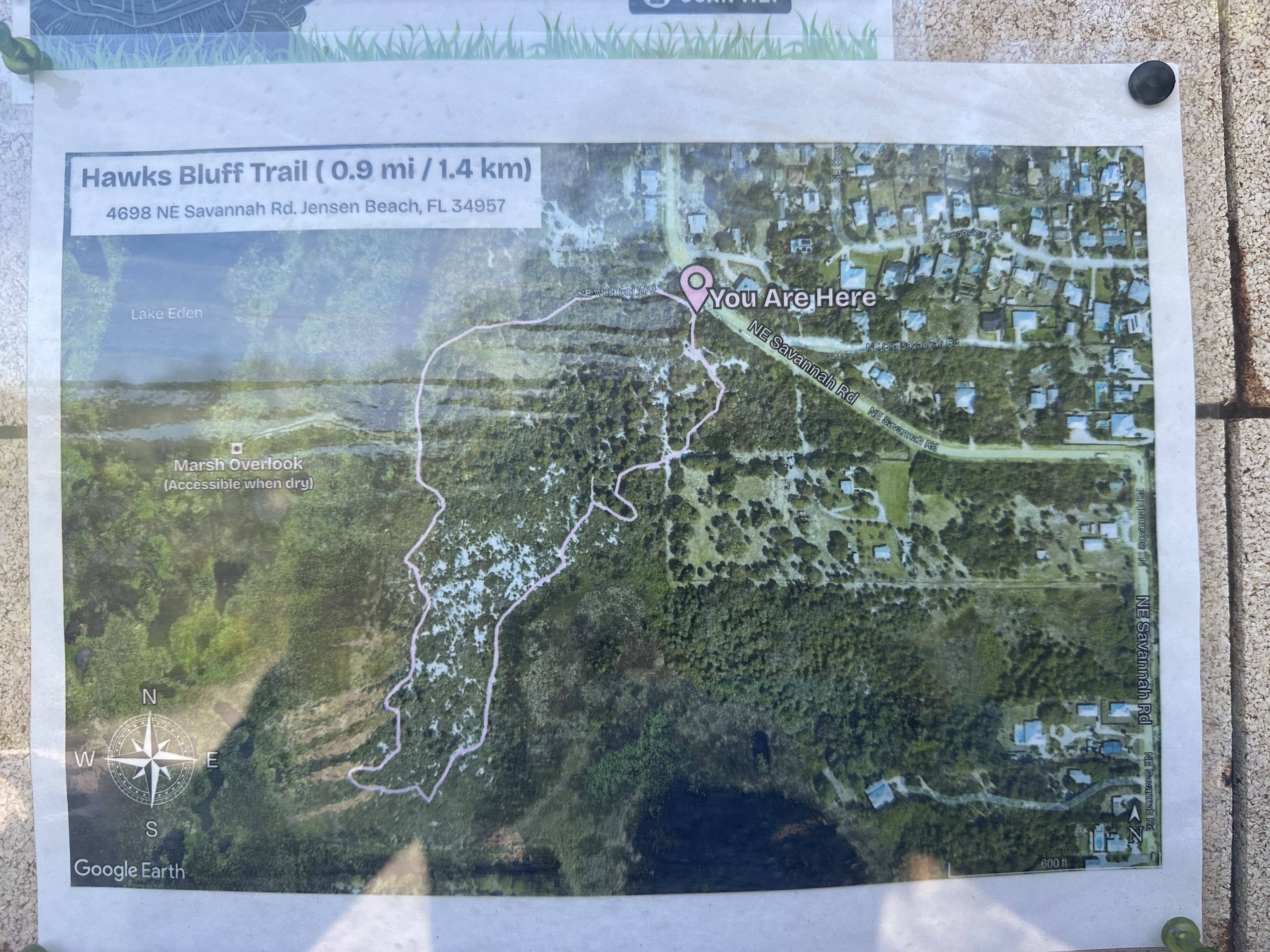
At this point, I figured I’d better do something “fun” with Ed and Diesel, forbid they never go on an unplanned historic weekend adventure again so I drove up Jensen Beach Boulevard to N.E. Savannah Road to visit Savannas Preserve State Park’s Hawk’s Bluff.
Ed and I had visited many times in the past 22 years with all of our other dogs (R.I. P. 🌈) but not with Diesel who is only a year and a half.
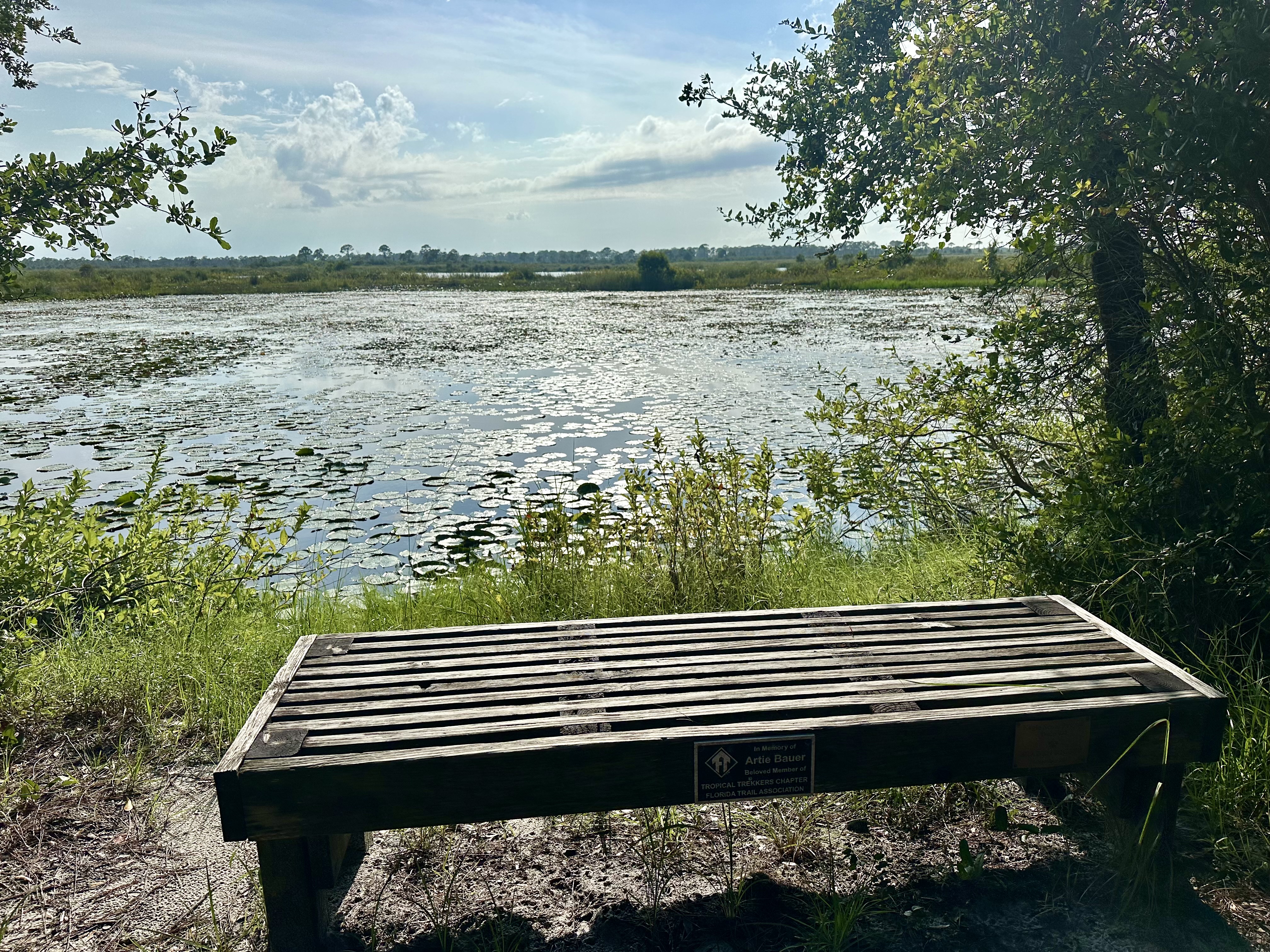
We entered and time seemed lost. Lake Eden of the Savannas was shining in the sun like an eternally beautiful old friend, the bench awaiting us.
Part of Lake Eden with bench, so peaceful.Like a Monet painting…
“Don’t get too close to the water Diesel,” I teased. “Alligators will think you are a beanie weenie”! Diesel was so excited but on a leash.
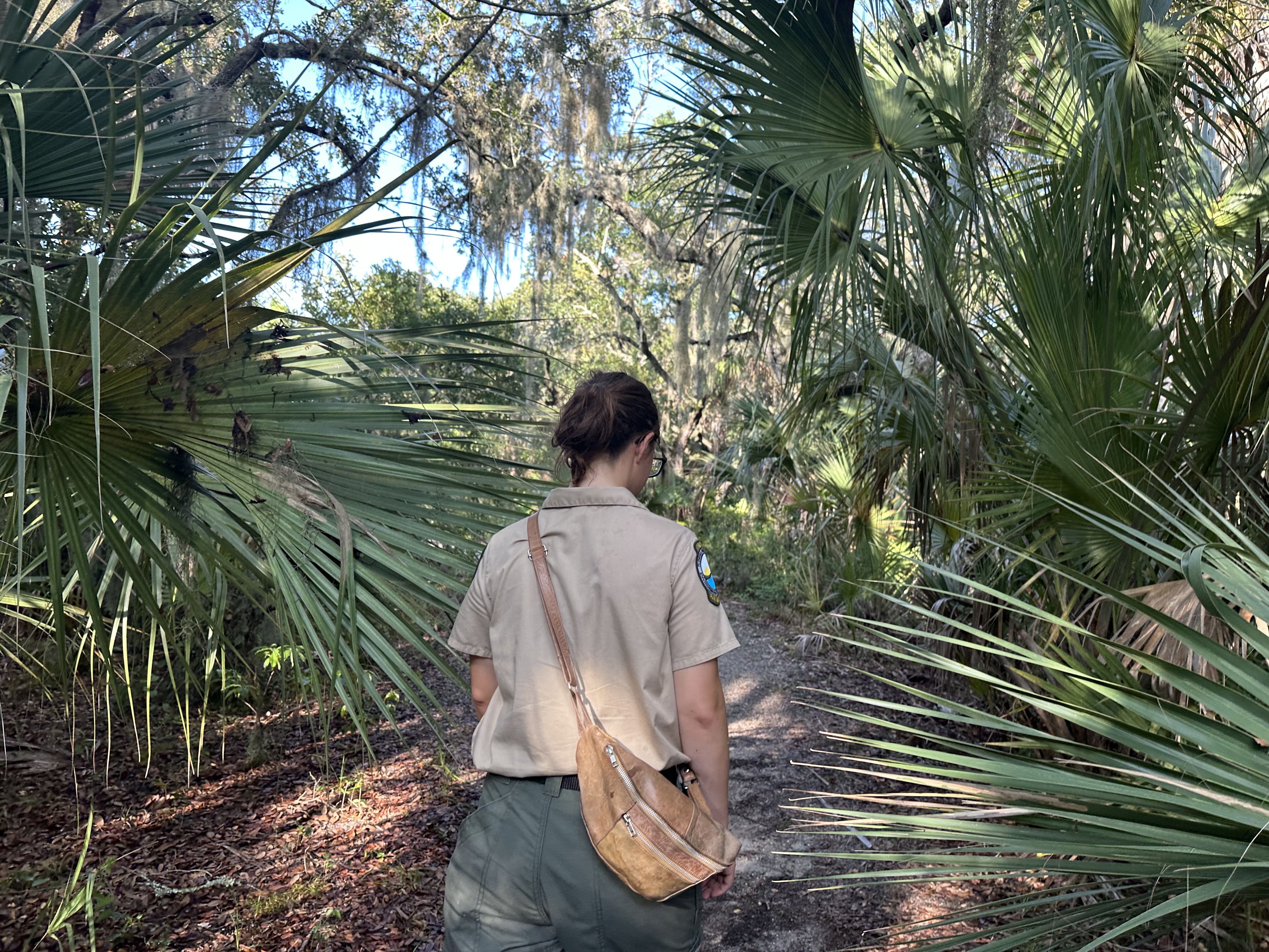
For the first time ever, we met a Department of Environmental Protection ranger, her name was Kristen. She was super nice and told us all about the approximately one mile trial, a mixture of scrub, hammock, and savanna.
Ranger, Kristen, DEP leads us along the trail.
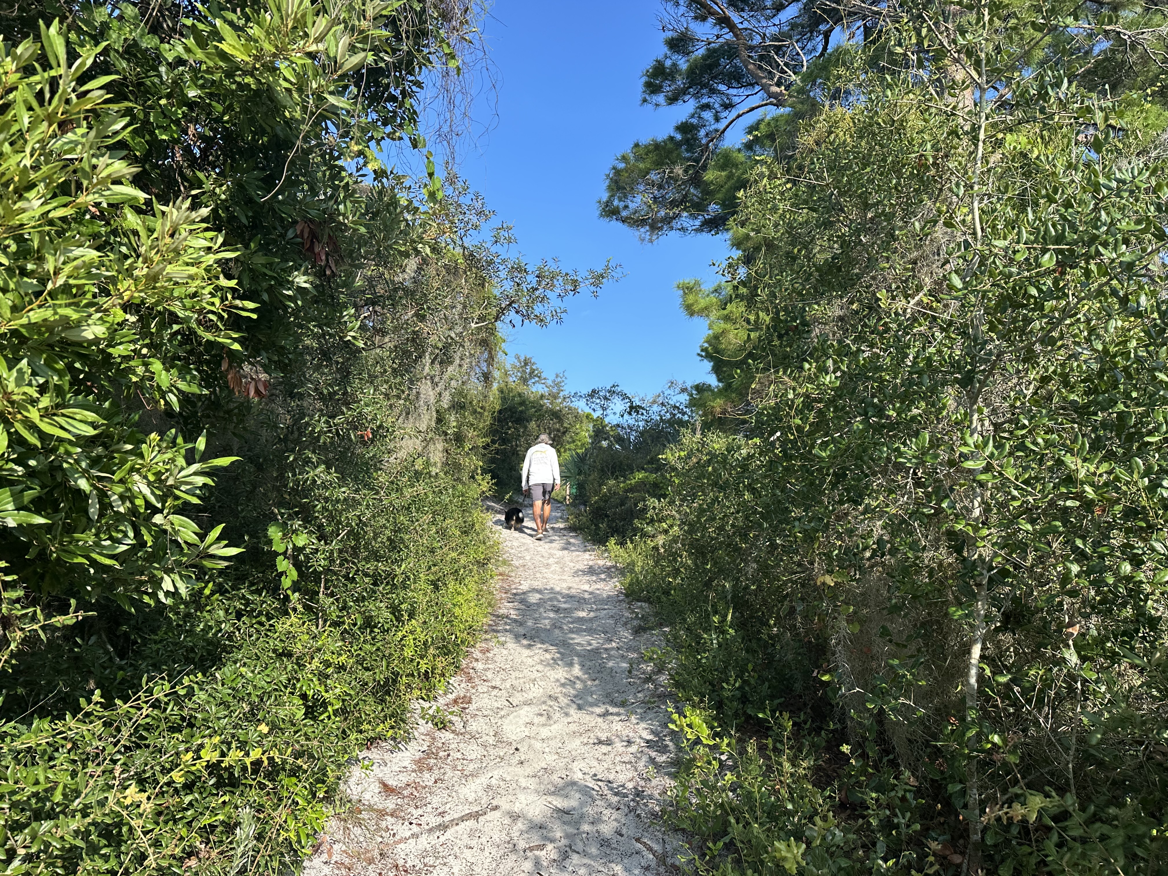
After a short hike, Ed and I made our way up the sugar sand hill and got back into the car. “Wow, I said. “So beautiful and peaceful and just a few miles away. History is cool, isn’t it”?
Ed smiled and I knew he had fun even if he wouldn’t tell me so. 🙂 Diesel always has fun if he gets out of the house!
It was day like another day, except I was up at 5:30 am. I’m never up at 5:30 am unless my husband Ed has convinced me to go fishing, or years ago when I was teaching high school.
My husband Ed was snoring in neutral and Diesel, our corgi, was peacefully lying by. I lay there eyes wide open. “What’s going on with me”? I thought. I shut my eyes hard trying to get back to sleep. I heard a little voice in my head: “Why don’t you get up and do something”? I closed my eyes even harder. Then for some reason I sat straight up, got dressed, and headed for the beach.
The morning was so peaceful. Being a night owl, morning is a time of day I rarely experience. As I pulled out of South Sewall’s Point onto AIA I thought, “You know Jacqui, you really don’t take advantage of this beautiful place you live. The call of the ocean is just moments away, everyday.”
Dustin showing me how to blow into a conch shell…
Turning onto MacAurthur Boulvard I drove through the old Indian River Plantation and out to Chastain Beach. It was like going to Church after a long absence. Scott David, the “mayor” was there filming wildlife with his drone, a young man named Dustin was blowing into a conch shell – its ancient sound reverberating across the water – and Dr. Duke Duncan was happily paddle boarding surrounded by friendly sharks. It was glorious!
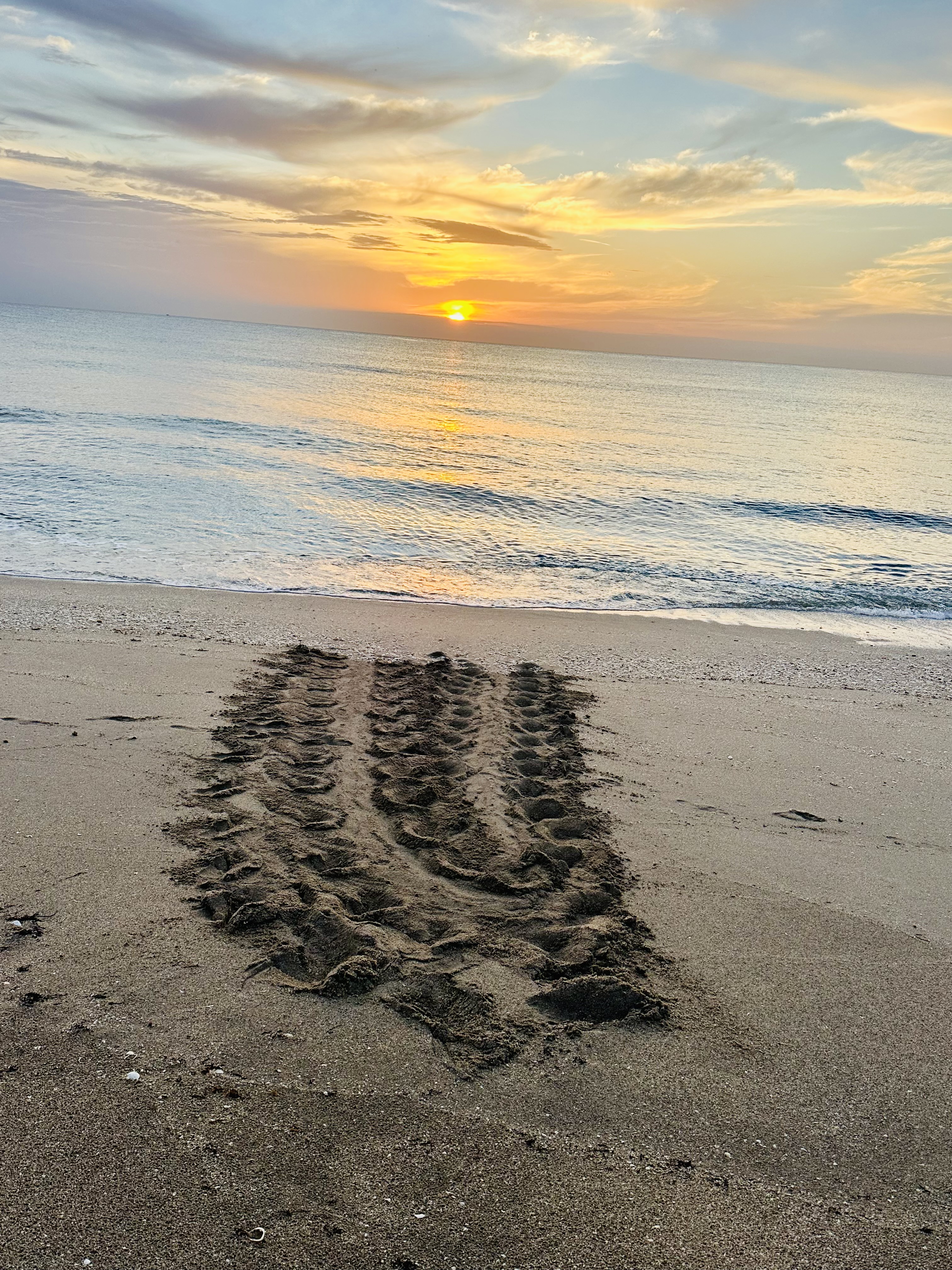
The sun was rising and I was surprised to see young and old wading through the gentle waves so early in the morning. Looking around, I noticed multiple sea turtle tracks. A young woman and her friends were gathered watching a baby loggerhead sea turtle lying limp in the sand. I watched, thinking how good it was these young people were out caring about Nature. I approached.
“He’s alive,” she said, “he’s just too tired…”Screaming seagulls darted overhead, hungry for breakfast. The heat of the sun was slowly intensifying.
A false crawl – -when the sea turtle turns around having changed her mind…Scott David is the “mayor” of Chastain Beach. See his incredible nature photography on Instagram, saltlife66, or Facebook, Scott David Butler. Amazing!A very tired baby sea turtleTurtle tracks
“Hmmm,” I said. “What should we do?
“Well I know we are not supposed to touch them…” the girl said. “But it’s definitely going to die or get eaten. Many don’t make it I guess.” The kids looked at one another.
“That’s a good idea,” said the girl, ” but we are just visiting the area, could you do it?”
“Of course I can”, I said. So I did.
The kids watched as I dumped out the tea that was in my Gator cup and filled it with seawater. We packed in some seaweed too which was everywhere along the shoreline. I wanted to help the little sea turtle keep its head up. Sea turtles breathe air; we didn’t want it to drown. “Yes thousand of years ago they lived on the land,” said the boy.
Baby sea turtle atop seaweed as can breathe and not drownLower right of baby loggerhead sea turtle notice the umbilical/yolk sac attachment trailing from the underside’s “belly button”. This provides nutrition for the first hectic days of the hatchling’s life as it goes to sea. I had no idea!
I went home to tell Ed where I was and was going. When putting the little sea turtle into a larger bucket, I noticed he or she had something like a placenta coming out of its stomach. “Ed do sea turtles have belly buttons”?
“Look it up ,” he mumbled making his coffee.
I read out loud: “Loggerhead hatchlings have a temporary “belly button” or umbilical scar – on the center of their lower shell (plastron). This small protrusion or dimple marks where the hatchling was attached to their yolk sac in the egg. This sac provides them with vital energy for about the first 3 days as they dig to the surface, make it to the ocean, and swim out to sea — sometimes continuously for over 48 hours tor more towards the Gulf Stream. — Only about 1 in 1000 baby hatchings make it to maturity.”
“One in a thousand?” Ed said, perking up and then helping me and the sea turtle into the car.
Carefully balancing a small bucket and making sure the little sea turtle’s nose was positioned on the seaweed so it could breathe, I drove south on US 1 from Sewall’s Point to Juno Beach. Every once in a while the little turtle lifted its head and its tiny flippers shook with what appeared to be excitement.
“Stay alive, little guy. We’re almost there,” I said, as traffic clogged the highway and gas fumes filled the air. I thought about how sea turtles have been swimming in Earth’s oceans for about 120 million years. With a little bit of help, they just may make it another million, I mused. I may have been dreaming but I swear I thought I head the hatchling say: “But will you?”
I looked down at the baby sea turtle incredulously. “Thanks for calling me this morning; I’m not sure if humans will make it or not, I said, but in any case, “I hope to see you again.”
Dropping off at the sea turtle at the Loggerhead Marine Center, Juno Beach, FL. A really nice touch, a certificate!
Dead seagrass in the shallows of Florida Bay, Flamingo, Everglades National Park, FL 6-26.Mangroves along Florida Bay are packed full of dead seagrasses, even so, I smile for the camera to alleviate the continual mosquito attack, June 2026. Photo Ed Lippisch.Hardened shoreline and unhealthy looking waters of Florida Bay, Flamingo, ENP, June 2026.
As I write, the skies above me are electrified. Thor is throwing bolts angrily and I am wondering if my ancient oak trees might get struck. Rain is coming, again, to Martin County, Florida. Martin has been fortunate this year to receive these waters from Heaven while much of the state has not.
On my recent trip with my husband Ed in June to Florida Bay, the waters looked thick and chalky. There were no manatees floating about lazily as in years past. Dead stinking seagrasses lifted from the bottom packed and covered the shoreline. Not a pretty sight.
As we all know, years ago, in an effort to develop our state, humans broke the flow of water flowing south from Lake Okeechobee to the Everglades, channelized the serpentine Kissimmee, and dug out multiple other canals to drain the state. The Buttonwood Canal connecting Coot and White Water Bay in Flamingo was one of the worst, injecting salt water into fresh and not allowing fresh to run into saline. A concrete barrier separates the two. The fallacy of this becomes especially evident during drought times.
According to the South Florida Water Management District’s DROUGHT IN SOUTH FLORIDA 2000-2001 “drought visits North America almost every year in some part of the United States and in nearly every decade. In Central and South Florida several droughts were reported: in 1932, 1955-1957, 1961-1963, 1971-1972, 1973-1974, 1980-1982, 1985, 1988-1989, 1990, 2001-2001” and in 2011 the Boyer Survey, an Archaeological Investigation of Lake Okeechobee was conducted as the lake was so low ancient Indian burial grounds were exposed.
Drought visual FL, July 7, 2026.
Always, south of Lake Okeechobee is one of the most important areas for wading birds. This year it has been very dry, not good nesting conditions, as shown in red by the US. Drought Monitor for Florida.
The sun does shine though…
Much good work has occurred since the 1970s trying to improve Florida’s water disconnect and in wet years so long as the rain “falls in the right place” water can be sent south to Florida Bay. But in years like 2026, there really was not enough water to send as is reflected in this July 9th SFWMD chart as presented at the Governing Board Meeting. Not to mention the thirsty and politically savvy sugar fields are unquestionably first in line with permits, political contributions and history ….
SFWMD chart reflecting water sent south. 2026 so far is not much.
But there are alternatives….
Gil Smart and Eve Samples of Vote Water and Friends of the Everglades located in Stuart have been politely presenting a theory, really an old theory in new form. Their RESCUE THE RIVER OF GRASS campaign advocates for the public acquisition of at least 100,000 acres in the Everglades Agricultural Area for storage, treatment and to send clean water south to Florida Bay.
Of course the EAA Reservoir, which I completely support is the “crown jewel” of Everglades Restoration and the DeSantis Administration has done great job keeping this fire burning and funding this hard fought necessity. But I am worried that when this administration turns the page in November, that “the powers that be” could highjack the EAA Reservoir to service agricultural needs over sending water south to Florida Bay – the Savings Clause.
Maybe I’m paranoid? Maybe I’m afraid history will repeat itself?Maybe I’m right?
As we turn the corner this General Election, let’s keep our eye on restoring the River of Grass and the EAA Reservoir and all the politics that surround it. We have to.
An osprey perched above Florida Bay looking for fish…
“Gateway to the Glades” Robert is Here Fruit Stand and Farm Est. 1959.
On our recent trip to Everglades National Park, Ed and I stumbled upon what I consider to be the best fruit stand in North America. On our American Great Loop Journey, Ed and I visited quite a few, but none compare to this. The name of the stand is “Robert is Here” and it’s located in Homestead, Florida. If you want to visit, I’d go now as Robert’s is surrounded by conspicuous newly constructed apartment buildings in just about every direction. As they used to say at the South Florida Water Management District, “houses, the final crop…”
Apartment buildings can be seen encroaching from every direction. Here just across the street
Ed and I stopped by on our way back to Stuart from fishing in White Water Bay. We’d noticed the fruit stand coming in, in fact I’d seen it multiple times over the years, but I’d never stopped. Ed is always in a hurry to get home…
“Hey Ed, for my birthday, let’s stop at this fruit stand”. He threw me a glance, then smiled, he knew he had to capitulate.
It was a Sunday and people were swarming the place. Finding a parking place was not easy. Once inside, we understood why. It was amazing!
There were tropical fruits of all kinds, some the size of footballs. Apparently Robert, standing behind the cash register in the photo below, established the stand by himself in 1959 when he was just six years old. His father, disappointed that little Robert had not sold the cucumbers given him, constructed a sign to accompany the boy at the table. The sign read: “ROBERT IS HERE.” By noon, all of the boy’s cucumbers were sold, and as they say, “the rest is history”.
Robert who started the fruit stand in 1959, stand behind the counter today. He added up what we bought on a paper bag and did the math in his head. Pretty cool!
The same corner little Robert stood on in 1959 is today the best fruit stand in North America..along with a petting zoo, wood carvers, artist, and specialty vendors. Like a time warp, one is transported back in time when Florida was Florida. So refreshing!
Jackfruit is the larges tropical fruit that grows on trees and can read 80 pounds.I think this fruit is a sapodilla. It tasted like kind of like a pear and the flesh was a beautiful color.Robert obviously bought up more than the corner, and today the fruit stand covers much land featuring artists and a petting zoo. Robert’s last name is Moehling.The zoo included a number of emus of which the public, mostly joyful little kids, could feed fresh watermelon!
I cannot imagine that this iconic South Florida fruit stand, the best in North America, would ever be sold and turned into characterless apartment buildings, but in Florida, who knows. It seems in the present state we’re selling our soul for a bunch of houses.
Ed and I were attacked by an army of mosquitoes at the entrance to Everglades National Park. 🙂
Ed asked me what I wanted to do for my 62nd birthday. My immediate reply was “Let’ go to Everglades National Park”!
In order to entice him, I even promised to go fishing, something I usually do not do as I feel sorry for the fish. “We’ll throw them back,” I laughed. I’ll learn to identity them. It will be fun”!
The traffic was brutal, but we made it there from Stuart to Flamingo, the resting place of Guy Bradley, who in 1902 became Florida Audubon’s first game warden tasked with protecting wading birds. Of course he was shot and killed after confronting a man and his two sons hunting egrets for their plumes. At the time plumes were worth more than gold. Warden Bradley and others like him changed the course of environmental history – with their lives. Many do not remember him today, but rather focus on enjoying the natural resources of the area.
Guy Bradley’s memorial, Flamingo, ENP.Repurposed steel shipping containers provide a very nice hotel experience at Flamingo, ENP and have a beautiful view of Florida Bay.View of Florida Bay from our lodge room.
Ed and I were pleasantly surprised by the quality of the lodge. Repurposed steel shipping containers make for a great stay. Very clean, functional and affordable, Ed and I plan to return.
Carolina Skiff rented for the day provided a fun day on the Buttonwood Canal, Coot Bay and spectacular White Water Bay.Ed practicing his casting on White Water Bay.Ed teaches me how to tie a special knot.I drove the boat. Captian for the day!
It was in the 90s , but with a breeze the mosquitos were in our wake. In the early morning Ed and I took to the water. I captained the skiff and Ed practiced his fly-fishing.
So hot! Water so still! Not a one fish bite, but believe it or not, a school of mullet jumped into the boat!
Mullet jumped in the boat!
Ed asked if I wanted to cut them up for bait. “No”! I said, and we returned them to the water to reunite with their friends.
Smiling from ear to ear, I recalled the stories of the late Ernie Lyons, Editor of the Stuart News, who wrote about St. Lucie River’s early days when there were so many fish in the river they jumped into your boat.
“Ed we’re just like Ernie Lyons!” I teased. Ed rolled his eyes.
The mangroves provide habitat for crocodiles and many other birds and animals.Crocodiles are salt water reptiles and prevalent in ENP.
As we approached the shoreline, I saw the crocodile. So ancient, so wise, so intimidating. I slowed down to be careful to go around him and thought of all the changes his kind have seen in 240 million years.
Harbour Master, Reuben, welcomed upon our return.
Returning after a great day, Harbour Master, Reuben provided excellent service helping bring in the skiff. As I stepped out of the boat, I asked about the gigantic osprey nest still ominous and hanging.
“This year the female osprey returned as she has for many years. She called and called and called, but the male did not return. You know they mate for life,” Reuben said. “She was crying for over a month. But nothing, no mate, no chicks. We really miss them; they are like family.”
“So sad.” I replied….
I looked at Ed and thought about how lucky I am that he always comes home.
“Hey babe, do you want to get a drink”?
Osprey nest at Flamingo. No chicks in 2026.
We made our way to the Flamingo Lounge and Restaurant right next to our cargo lodge room, ordered a couple of vodka tonics, telling fish stories about the tarpon we will catch next time! 🦟
The Flamingo Lounge and Restaurant although redone, remains a classic.Flamingo Lounge, a classic….
These aerial photographs of the confluence of the St. Lucie and Indian River Lagoon were taken on March 26, 2026 by my husband, Ed Lippisch. I wanted to share on by blog post to document what the water looks like during low tide and during a drought. The time was around 11:45; approximately an hour after the lowest of low tide.
There has been more rain in our region than in other parts of the state, nonetheless there have been no release from Lake Okeechobee in over a year. You’ll notice the Sandbar’s returning sea grasses, nothing like those up to my hips as Is walked through as a young girl fifty years ago, but certainly much better than the horrible years of 2013, 2016, and 2018 when the river was a toxic mess and grasses could find no light thus withered.
Ed and I are grateful for the new lake operations schedule LOSOM and that the St. Lucie has been spared of late, but our hearts go out those suffering from not enough water. This includes the bird rookeries deep in the Everglades. Really returning to a River of Grass, now wouldn’t that be something….
If you want to know anything at all see my brother Todd’s website: eyeonlakeo.com!
~AERIALS
SLR/IRL around peninsula of Sewall’s Point, Hutchinson Island inside the Atlantic Ocean
Light plume exiting St. Lucie Inlet from local runoff and C-23/24 Canals
Sailfish Point and Sandbar area — notice seagrasses
View towards Stuart and Rocky Point
Plume
View over Sailfish Point on Hutchinson Island towards Stuart
Long view north
Another long view north in south is St. Lucie Inlet Preserve State Park, Jupiter Island
Witham Field at top of photo and breaking wavers over nearshore reef
These photos are part of a series of “reservoirs” that have been covered in my blog the past months and is meant to be educational. The South Florida Water Management District is to be congratulated on completing the STA, a feat! However we must ask ourselves about the significance of the algae bloom as seen in a couple of the photos below.
There is a lot to this subject but for today, it’s just the photos!
Geoffrey Smith and Ed Lippisch prepare for flight.EAA Reservoir/STA, 2-11-26. Ed Lippisch
Included are the ” STA 1-W, N side of Reservoir, Reservoir STA, and A-FEB.” Thanks SFWMD!
On Friday, February 6, 2026 , Ed and I joined a group tour of the C-23/24 Storm Water Treatment Area put on by Mark Perry and the Florida Oceanographic Society. ACOE’s Major Cory Bell drove along with us and was available to answer questions. It was a very educational and really fantastic day! This part of “Indian River Lagoon South” is about the North Fork of the St. Lucie River that has been negatively impacted by development and agriculture in St. Lucie County.
A large portion of the group consisted of family members: my husband Ed and me; my mother, Sandra Thurlow; my brother, Todd Thurlow and his wife, Deanna Thurlow who works for Florida Oceanographic and together with staff arranged the tour.
Todd and Deanna Thurlow stand before the 10 Mile Creek Reservoir east of C-23/24 STA also visited on this field trip.Mom and me at the C-23/24 STA, St. Lucie County, FL.
It was a chilly day so we were all bundled up as the wind whipped by. We drove from Stuart/Hutchinson Island to St. Lucie County taking Highway 70, or Okeechobee Road, to the intersection of Sneed Road. This area was once citrus and other agricultural lands and is now part of Indian River Lagoon South – part of CERP – and on the docket to help clean up the impaired waters of the St. Lucie River.
I know I have written on this before, but I wanted to share some of my photographs and the hand outs as a resource for the public. We also visited Ten Mile Creek Reservoir and Strom Water Treatment area. For simplicity and so as not to confuse, I am focusing on the C-23/24 STA.
You will notice that the C-23/24 STA presently resembles a desert. The project should be completed by the Army Corps of Engineers this year. No water yet, but as we know, it will come….
We also need the two reservoirs to be built. The IDS or scheduled of the ACOE will be coming out soon to let us know where funding and priorities for 2026.
Partial view of the 10,000 acre C-43 Reservoir, 1/24/26, Ed Lippisch.
Today I am going to share all of the aerial photographs of the C-43 Reservoir that were recently taken by my husband Ed Lippisch. I think it is important to be able to “see” these huge CERP/Comprehensive Everglades Restoration Plan projects that are, or should be, coming on-line.
My post is meant to be a visual resource.
The C-43 Reservoir encompasses more than 10,000 acres and is located on the west coast near LaBelle, Florida. Ed took these photographs on January 24, 2026 and the reservoir appears to be empty of water, as it has not rained much and much of Florida has drought conditions.
What is the Interconnect or C-23 Estuary Discharge Diversion Canal? What does it look like?
Today I am sharing my husband Ed’s aerials of this new South Florida Water Management District built canal that is part of the Comprehensive Everglades Restoration Plan/Indian River Lagoon South project to help clean up the St. Lucie River. You may have seen it under construction when driving west on Highway 714?
Interconnect and C-23 canal
Interconnect and C-23 canal.
Northern Inflow Pump Station (S-457)
Another view C-23 canal and Interconnect
Interconnect Canal intersection with C-23 Canal
Interconnect Canal
Interconnect Canal
Interconnect Canal
Intake Canal C-44 Canal with C-44 Reservoir and STA
Interconnect Canal taken January 9, 2026 by Ed Lippisch.
“The C-23 Canal to C-44 Reservoir Interconnect Canal Project” as published by the South Florida Water Management District on 7-26-22 states that the project’s purpose is to remove excess water from the C-23 Canal to be diverted, via the Interconnect Canal, to the C-44 Reservoir and Storm Water Treatment Area and eventually cleaner to the C-44 Canal which leads to the St. Lucie River.
See north/south pink line connecting C-23 and C-44 Reservoir/STA.
~Project elements include a Northern Inflow Pump Station along the C-23 Canal (S-457)
~Culvert Crossings at CR 714 (S-458) and Coca Cola Road Areas (S-459S)
~Interconnect Canal’s official name is the (C-457)
~The North Segment (1) is three miles long; Middle Segment (2) is three miles long: and the South Segment (3) is one mile long.
~The Southern Fixed Weir Spillway and Service Bridge Structures is called (S-460)
Ed Lippisch’s aerial of the C23/24 STA looking east taken 1-6-26 in St. Lucie County. This STA will clean waters to the St. Lucie River from two reservoirs yet to be built. This STA is scheduled for completion by ACOE by end of 2026 but the reservoirs still need to be constructed.
Happy 2026! After a break the Florida Legislature is back in session and Everglades Restoration is back in the news. About a week ago, my husband Ed asked me what I wanted photographed for the new year, and I replied: “The C23/24 Strom Water Treatment Area in St. Lucie County.”
Ed came back after a morning of flight and said: “I can’t find it.”
“Hmmm, I thought. Maybe because it’s not full of water yet, it is hard to make out?”
After a little more study and pinpointing the entirety of the C23 and C24 Canals we found it! Because the reservoirs are not yet constructed there was little change to the look of the land. Thankfully storm water treatments areas “blend.”
So what “it”?
The C23/24 STA and Reservoirs are the northern part of Indian River Lagoon South. (IRLS) “Indian River Lagoon South” is the St. Lucie River’s portion of the Comprehensive Everglades Restoration Plan (CERP).
This is a very important part of the project and like the rest of Indian River Lagoon South has been a long time coming. And though Governor DeSantis did not mention it yesterday in his State of the State speech, it must be funded.
So where are things now?
Both the Army Corps and the South Florida Water Management District are responsible for completing the project.
Drew Bartlett, Executive Director of the South Florida Water Management District noted the following:
~C23/24 Strorm Water Treatment Area is under construction by the Army Corps of Engineers and should be finished in 2026. (above photo)
~C23/24 North Reservoir (to be built by the Federal/ACOE) is ready for construction, but not funded.
~C23/24 South Reservoir (to be built by the State/SFWMD) is ready for construction, but not funded.
~C25 Reservoir (State/SFWMD) is in design and will be ready for construction in 2027.
These giant projects are/have been a shared responsibility. The ACOE and the SFWMD are/have been a team…
Excerpt ACOE IRLS poster includes both Martin and St. Lucie counties. C23/24 is located just north of Highway 70 close to the St. Lucie County Fairgrounds. C25 is even further north and all majorly affect the St. Lucie watershed – once all connected to the famous Alpatiokee Swamp that cleaned and fed the beautiful St. Lucie River.
The Governor’s last budget request focused on fully funding the rest of the EAA Reservoir and CEPP, very important! But did not include a request for Indian River Lagoon South’s C23/24/25 components. If we’re going to finish the job for the St. Lucie River, “it” will need to be included too.
The winds have finally calmed, the water has lost its anger, and from horizon to sky are long silver clouds that appear to be stuck in place. Captain Ed and I have been docked at Grand Manor Marina in Belhaven, North Carolina for the past six days.
Belhaven lies about 150 miles south of Norfolk, Virginia. We were making our way back to Stuart when Ed and I sought refuge from the massive nor’easter. Belhaven is the perfect place other than the pesky flies that find their way into the boat no matter how hard we try to keep the doors shut. I pride myself on not killing any of God’s creatures, but over the past six days I have became a lunatic with a flyswatter.
Finito cruised Chesapeake Bay for exactly one month. This was by coincidence and not by design. I prepared by re-rereading James Michener’s novel Chesapeake but I still wasn’t finished when we arrived in the bay. Completed in St. Michael’s, Maryland, the book again brought the history of this magnificent part of America into focus: the native people, the religiously persecuted Europeans who immigrated here, the pirates, the slaves, the wildlife that was brought to the brink of extinction, and the lands that sustain, but storms can bring crumbling into to the bay.
My favorite characters, besides the geese, were the Paxmores, Quakers, who became expert ship builders and leaders in the anti-slavery movement. The family evolves through the 1600s to the 1970s terminating in the character of disgraced Pusey Paxmore who is part of the Watergate scandal. This character was certainly inspired by the fall of President Richard Nixon who was raised a Quaker, as was Michener.
How does this happen? How do we lose direction even when we have a compass right in our hand? How is the destruction we inflict upon Nature symbolic of this? How can we do better?
These are the questions the trip made me think about, all the while having another Finito journey with Ed. But there are also lighter things. It has been quite fun watching Diesel grow up on the boat and watching Okee rule-the-roost. Whether the animals or us, there is certainly a closeness that occurs while traveling on Finito that is difficult to achieve while living at home. Nature’s rhythms help support this and become the fabric of every life. Perhaps most important, Ed and I have become very comfortable operating, communicating, and docking.
We will be leaving Belhaven, tomorrow and one of the places we will visit for the second time is Southport, SC just 120 miles south of here. A few weeks ago, an active shooter took his victims via boat in a waterfront restaurant Ed and I have visited in this tiny, sweet old fishing town.
No matter where one is, there is no escaping the world.
Finito’s journey has been both educational and beautiful. The bay borders both Maryland and Virginia; sometimes it’s hard to tell what state you’re in! Its enormous watershed drains multiple states. I’ll talk about that later, but first the fun part.
~The Chesapeake Bay journey has included Yorktown, (York River); Deltaville, (Piankatank River); Colonial Beach and Washington DC, (Potomac River); Solomons, (Patuxent River); Annapolis, (Severn River) and St. Michaels (Miles River.) St Michaels was the sole eastern stop and lies in on the Eastern Shore featured in Michener’s novel.
A page from Super Looper showing various stops boaters can take along C. Bay.
~First things first: WATER QUALITY
The Chesapeake Bay Program created, in 1983, falls directly under the United State’s Clean Water Act (Sec 117) and was established with a mandate to restore and protect Chesapeake Bay’s watershed spanning seven states: New York, Pennsylvania, Maryland, Virginia, West Virginia, Delaware and the District of Columbia. The Chesapeake Bay Regulatory Program provides funding to improve accountability assessment and enforcement programs.
Our Indian River Lagoon National Estuary Program in Florida, by contrast, is an outgrowth of the Environmental Protection Agency’s National Estuary Program created in 1987 under the Clean Water Act. There are 28 Nation Estuary Programs today; the Indian River Lagoon Program was established in 1990. Because it’s part of the National Estuary Program, its mandate is non-regulatory, but science-based.
Both programs are slowly making headway and both struggle to meet nutrient reduction goals of phosphorous and nitrogen. The IRL’s algae blooms and seagrass crashes are linked to an overabundance of nutrients, as are the millions of sea nettles – jellyfish floating throughout Chesapeake Bay’s waters. Ed and I saw hundreds, maybe thousands of jellyfish just about everywhere we visited in the Bay.
Nutrient pollution is the leading cause of water quality problems and is linked primarily to agricultural and urban runoff, it’s a frustrating predicament as it is non-point and coming from “everywhere.” The answer? Getting involved and voting in elected officials who care to tackle this issue.
Jelly fish in the water, St. Michaels, MD.Water filter full of jelly fish.
THE JOURNEY
Okee and Diesel competing for counter space, Chesapeake Bay 2025.
I. NORFOLK, VA, Elizabeth River (Tidewater Marina)
Ed entering the Elizabeth River, Norfolk. VA, with Diesel at his feet.
We entered Chesapeake Bay from the south entering Norfolk, Virginia’s Elizabeth River. The military’s presence on the river goes back to 1767 making the Port of Virginia older than the USA itself.
Naval Station Norfolk is the largest naval complex in the world. The river’s shoreline appears void of even a blade of marsh grass and is surrounded by multiple, massive naval and industrial facilities.
Even with the shore to shore industry, bottlenose dolphins greeted us. According to the Elizabeth River Scorecard, finally wildlife has been returning after decades of restoration efforts. While I enjoyed watching the playful dolphins, I could hear Ed talking on the radio to a war ship. Strange!
Warship
Cargo ship approaching!
II. YORKTOWN, VA, York River (Riverwalk Landing Marina)
Ed and Diesel sit before the 98 foot tall Yorktown Victory Monument – this monument can be seen many miles away.
Chesapeake Bay measures about 200 miles long and has a maximum of 35 miles across. Its multiple incoming rivers provide great stopping points for boaters. The first place we visited after passing through Norfolk was Yorktown, Virginia, on the York River. People were swimming in a designated area by the shoreline and when I read about the river’s health it was better than others, but facing tremendous development pressure.
The town itself is a museum. The streets still have the same names as they did during the Battle of Yorktown that determined our nation’s independence from Great Britain. The local museums and historic buildings are outstanding and bring this history to life. Such as the humiliating account of Britain’s General Cornwallis and his troops who attempted escape as they desperately rowed across river. To be docked upon this place of such history was quite remarkable.
Yorktown w/ General Washington, Commander in Chief; Major General Lafayette, Continental Army; Lt. General Rochambeau, French Army; Admiral de Grasse, French Navy – Battle of Yorktown 1781 -American Revolution’s deciding battle.
III. DELTAVILLE, VA, Pianakatank River (Fishing Bay Marina)
Deltaville, VA.
IV. COLONIAL BEACH, Potomic River (Colonial Beach Yacht Club)
After eating the best crab cakes in all of Chesapeake Bay, Ed and I left Deltaville, Virginia, an unspoiled town cradled in a beautiful cove of the Piankatank River.
A family of Mute Swans in the Potomac River.
Colonial Beach, Virginia, along the Potomac, followed. It is the birthplace of a boy who loved the river, George Washington.
Today’s Voorhees Natural Preserve provides sanctuary for birds and wildlife. One morning I awoke at sunrise. I was out on the bow when I heard a noise I had never witnessed. It sounded like a heavy whistling falling wind. And then I saw it. A huge swan! So heavy it could hardly fly! It made its way acoss the river and I knew I would never forget that moment. Swans, geese and ducks once here in the millions were almost eradicated by the long-guns that hunters used, unregulated, for decades. The birds’ comeback and the regulation on hunting practices is an inspiration.
V. WASHINGTON, DC Potomac River (Capital Yacht Club)
Mount Vernon, George and Martha Washington’s home, lies on the Potomac River just around the bend from Washington DC.On the bow approaching Washington, DC.The Washington Monument as seen from the Potomac RiverThe United State’s Capitol as seen from Finito.Ed and Diesel on the stairs of the Jefferson Monument, Washington, DC.Lincoln MonumentEd at Washington Monument with National Guard walking past.
Entering Washington, DC was an emotional experience not only because it was a slow, dramatic view approaching by boat, but because of this unsettling time in American history. Right away, we saw diverse citizenry and the presence of the National Guard. Ed and I walked Diesel to the Jefferson Memorial. Diesel always takes the edge off things.
The Municipal Fish Market (1805), America’s oldest continuously operating out door market, was right there. It was incredible to watch, but I doubted they were selling Potomac crabs since the Potomac Conservancy reports that the river is not safe for swimming, nor the eating of fish. The marina’s water looked terrible with floating trash, foamy water, and excess vegetation.
Highlights included The Capital Mall and the Lincoln Memorial. Later we visited the Portrait Gallery, and the National Museum of African American History and Culture. I must say, the food was outstanding, including the food truck hot dogs!
The Municipal Fish Market at The Warf is the oldest continuously operating open-air fish market in the US, est. 1805.George Washington, Portrait Gallery.
VI. SOLOMON’S ISLAND, VA, Patuxent River (Calvert’s Marina)
Solomon’s lies in Maryland along the Patuxent River, the longest and deepest entirely within the state of Maryland. In its hey-day the late 1800s, Solomon’s was named for a man who opened a profitable oyster cannery. Those days are long gone. Today tourism dominates this quaint retreat.
The Patuxent River Keeper, and the local museum tell the story of abundance, and eventual over-harvesting. This is a familiar story throughout the United States including our St.Lucie River and IRL.
Solomons Island, MD.
VII. ANNAPOLIS, MD, Severin River (Annapolis Yacht Basin)
Annapolis, the capital of Maryland is a wonderful city, although I’d say they need to work on more green space and less asphalt. Right away, Ed and I found the Irish Pub that we had visited last time, Galway Bay.
The Naval Academy, the remarkably intact historic city, and historic state capitol are hard to beat. One could spend a lifetime sailing and studying American history.
We missed my Uncle Russ’ friend, Dave from the Naval Academy, (both Class of ’58) who traveled with us last year on America’s Great Loop, but he came and visited us in Solomons. Terrific!
Irish Pub!Annapolis, the capital of Maryland, lies on the Severin River.The Maryland State House is the oldest state capitol in continuous legislative use completed in 1779.George Washington famously resigned from military service at the Maryland State House, Annapolis, MD on December 23, 1783.The Naval Academy lies at the heart of downtown.Annapolis grad, Class of ’58, Dave Banner visits
~Road trip to Philadelphia, Pennsylvania. For me, the best part of our visit to Annapolis was driving to Philadelphia, Pennsylvania to visit my niece Nat who is getting her PhD. in Biomedical Engineering at the University of Pennsylvania. She and her roommate live about thirteen blocks away from Independence Hall, the birthplace of America! What a place to call home! It was a wonderful visit.
Independence Hall where both the Declaration of Independence and the Constitution of the US were debated and adopted. A World Heritage Site since 1979.JTL, Nat, Lauren and Ed enjoyed a great meal just blocks away!
ST. MICHAELS, MD (St. Michael’s Marina)
St. Michaels, Maryland, was the only city we visited on the Eastern Shore.
This adorable little town with roots in the 1600s is living history. It was here where James Michener chose to research and write his famous novel Chesapeake. It was from this region that abolitionist Frederick Douglass ran to freedom in Philadelphia just across the bay.
St. Michael’s gets its name from an Episcopal Church that predates the town, but Ed and I decide to visit a Methodist Church service as it was dog friendly. Diesel was not on his best behavior but since the sermon was on patience, Ed and I just looked at each other and let it go. Fun!
Sea level rise is a major issue, especially on Chesapeake Bay’s eastern side. During our visit both docks and the shoreline areas of the town were partially underwater. Locals did not make a big deal out it, and when I thought how this area was once a marsh, it really did not seem a surprise. All this water mixed with storms means erosion…
Even Michener’s book written in 1978 ends with Devon, the lands of the ruling family, crumbing over time and then falling into the bay after a hurricane. The novel begins with a Native American determining not to build on this same land hundreds of years earlier because he could see the instability. A foreshadowing…
Finito arrives at St. Michael’sSt. Luke’s Methodist Church 1874 originally 1781.They advertised dogs allowed so Ed and figured it would be a good outing for us and for Diesel!Rev. Curtis Ehrgott’s sermon focused on patience, just what Ed and I needed to hear. Diesel whimpered and jumper the whole time.Frederick Douglas lived in St. Michaels for 3 years – there is a walking tour of his life.Coastal flooding…A walk on the dock to the other side.Ed carries Diesel to Finito as his legs are too short to stay above water.Beautiful evening in St. Michaels.The iconic Canada Geese have arrived!Geese fly over in a V formation – October – May Chesapeake Bay!Little fish swimming in circles were everywhere!
Since St. Michael’s we’ve headed south on the bay through Solomon’s, Deltaville and Norfolk. We are now 150 miles south of Norfolk in Belhaven waiting out the weather. Ed’s making cookies and I’m swatting flies! It’s just another beautiful day!
Getting to Chesapeake Bay has turned out to take a bit longer than I anticipated, but that’s OK. It all about the journey. We are having a great time. We left Stuart, Florida on August 8, 2025 and today we are on our way to Coinjock, North Carolina. We have traveled about 800 miles and have just over 100 more to arrive at our destination, Chesapeake Bay. Last time I blogged, Finito was docked at Amelia Island and our puppy Diesel had become “the mayor.”
Finito docked along the marshes near Sunbury Crab Company, Sunbury, GA.
Since Amelia Island, we have stopped at Jekyll Island, GA; Sunbury, GA; Isle of Hope, GA; Daufuskie Island, SC; Hilton Head, SC; Beaufort, SC; Charleston, SC; Georgetown, SC; Myrtle Beach, SC; Southport, NC; Swanboro, NC; Beaufort, NC; Oriental, NC; and Bellhaven, NC.
If I had to choose running themes they would be: salt marshes, wide beaches, historic churches, buzzing cicadas, and a reverberating wake from Sherman’s “March to the Sea.” Thankfully many of the ancient oak trees still stand and much of the Deep South today is bustling.
Ed walks Diesel under an ancient oak, Isle of Hope/Beaufort, SC.Debra Green sells beautiful Mount Pleasant Gullah hand woven sweetgrass baskets..Historic Marker, Daufuskie Island lies right before Hilton Head.Daufuskie Island, SC.St. Helena’s Anglican Church, built in 1724, Charleston, SC.
The waters here are alive. Winds, tides and strong currents push through extensive marshes — many, once rice paddies tended by slaves.
Certainly, in specific areas of Georgia and South and North Carolina, there is water contamination, mostly from industry. But unlike the St. Lucie River/ Indian River Lagoon, a combination of tides and marshes regularly cleanses.
Here, one finds massive estuaries and important bird migratory flyways such as Port Royal Sound between Hilton Head and Beaufort, SC; and the Neuse River near Oriental, SC. – which is at its mouth is one of the widest rivers in the United States.
It hasn’t been all Intracoastal or river: From Charleston to Georgetown, Ed insisted on going “outside” in the Atlantic Ocean due to shallow readings inland. I agreed, so long as I could see land and know which way to swim in case Finito stared sinking. Along the way, Okee barfed, but other than that, the wave action wasn’t too bad.
Towns and cities have included old fishing villages, former plantations lands, and incredible historic cities that now attract tourists and modern industries. In fact, many, especially the young, are moving this way. For instance, my niece Evie and her boyfriend Clay live and work in Mount Pleasant/Charleston, South Carolina. They love it there and it was so wonderful to see them and meet their rescue dog, Tiki.
Great American Egret in marsh, Charleston, NC.Finito is a 55 ” Fleming with a 5″draft. Sunbury, GA.
Some estuaries are enormous. Port Royal Sound, mentioned above, lies between Hilton Head and Beaufort, South Carolina and is one of the largest estuaries on the Southeast Coast of the United States. Its salt marshes are key.
According to a Prichard’s Island Research & Living Shores Coalition sign, South Carolina has more salt marsh than any other state on the Atlantic Coast. Half the salt marsh on the east coast is in South Carolina and half of that lies in Beaufort County at Port Royal Sound. Of course, salt marshes serve as nurseries and habitat for numerous species- an entire food chain. Unfortunately, our Indian River Lagoon has seen up to an 85% reduction in salt marsh coverage.
Ed and I with my neice Evie Flaugh and her boyfriend Clay who we visited in Mount Pleasant, part of Charleston.Ed and Diesel in front of the South Carolina Society, established 1737. Charleston, SC.Diesel took his first horse drawn carriage tour in Charleston, SC.
As one would imagine, boating requires more attention in these waters! Charts can’t alway reflect sudden movements of sand. A couple of days ago, while cruising in the Intracoastal Waterway, Finito ran aground in Bogue Sound between Swansboro and Beaufort, NC. Before that, near Southport, we navigated the Cape Fear River and today on our way to Coinjock it will be Albemarle Sound– a body of water that was as rough as an angry ocean last time we went through while on America’s Great Loop.
So before I close, are you curious? 🙂
In case you are, here’s my running aground in Bogue Sound story…
Finito has a five foot draft——
~It was an extremely windy, sunny, gorgeous day and though in the channel, Ed and I sat in the pilot house and watched as Finito’s depth finder slowly went from 12 to 7 feet. And then to 4.2 feet in what seemed a matter of seconds. We had just been discussing how wind could exacerbate the shallowness and we were watching and holding our breath. But when it happens, you still can’t believe it!
Our conversation went something like this:
Yikes!Bogue Sound, NC and surrounding waters, on our way to Beaufort, NC.
“Isn’t North Carolina where we got caught in the current on the Loop that time and humiliatingly smacked the dock losing a few fenders in front of all those people?” I inquired.
Ed was not amused as tried to assess the situation.
“Beaufort!” he barked.
“Beaufort, again! We’re on our way there now. I can’t believe it!”
I walked to the stern listening to the engines as Ed unsuccessfully tried to back out. I hollered: “You know sometimes when you try to force things you make them worse!”
Ed ignored me and kept doing the exact same thing.
I stuck my head in the pilot house. “I’m putting Okee in the bedroom.” I said. “This could get hairy! “I could hear Diesel’s loud barking.“Be sure to keep the doors closed so Diesel doesn’t jump overboard!”
In high stress situations, Okee is taken to the bedroom.Ed waits for Sea Tow in Bogue Sound, NC.
My job was once off to let loose their lines.
As I carried Okee I could hear Ed on the phone with Sea Tow. He matter-a- factly gave coordinates. After I placed Okee on the bed I regrouped and tried to be a good first mate clearing the decks.
Sea Tow arrived, I noticed they never asked any questions, they just helped. This is what Ed always says he wishes I would do. I thought about this. And then, once again, I couldn’t help myself.
“Captian Ed, would you please ask the men if there are more sandbars along the way?”
Ed stared at me and there was silence until I heard a young kind southern voice: “It’s deepest near the red channel markers ma’am…”
“So we should steer left. Thank you so much,” I said shooting Ed my most charming glance.
Ed looked at me sternly, then smiled. Getting there is half the fun, isn’t it? We were underway —leaning port side—- to Beaufort and then Oriental…
Cover features a beautiful painting by renowned Jerry Rose. A Pictorial History of Palm City Florida, by Sandra Henderson Thurlow and Jacqui Thurlow-Lippishch.
Southeastern Printing has a long history in Martin County- over 100 years. Don Mader is the present owner of this excellent company now based in Miami. Long time employee, Darcey McNiff Thompson, informed my mother and I of the win and kindly stopped by mom’s house to share the certificate. Heidi Rich of richworks graphics was the designer of the book, and my brother Todd worked the historic maps on the inside covers. Sandra Henderson Thurlow and I wrote the book, and to this day, this experience has been one of the most rewarding of my life. The book was published in 2024.
Southeastern Printing had its 100th birthday in 2004 and is a product of Martin County. Today it is owned by Don Mader and is located in Maimi, Florida.
Thank you to Southeastern Printing and everyone who loves history! To purchase a book, see my mother’s website here. Photographs below shared by Darcey McGriff Thompson.
The water has called once again and Ed and I are underway. This time our trawler journey will be to Chesapeake Bay. We have new puppy, Diesel, as we lost our beloved Belgium Shepard, Luna, last year while we were on America’s Great Loop. Okee, our beautiful 17 pound cat, will be making the trip too.
After our Great Loop adventure it was wonderful to return to Stuart, but boating has become a bit of a calling especially now that we are retired. We chose Chesapeake Bay because while passing through on the Loop we loved it most and decided to return. The Chesapeake Bay is the largest estuary in the United States, its watershed extends into states of Maryland, Virginia, West Virginia, Delaware, Pennsylvania, New York and our federal capital, Washington D.C. Just magnificent!
Watershed of Chesapeake Bay, Wiki.
While on the Loop I read James A. Michener’s CHESAPEAKE, and Ed and I enjoyed talking about the estuary’s long documented history and the spectacular wildlife. In fact the huge, loud, honking, close-nit Canada Geese, widely featured throughout the novel, became the symbol of our Loop journey. And then of course, Chesapeake Bay is a poster child for climate change and a leader in restoration attempts that predate National Estuary Programs such as our Indian River Lagoon. Chesapeake has much to teach about improving our impaired waters and the power of cooperation.
Canada Geese were sacred to the native people of the Chesapeake Bay area as survival depended on their coming. Later the European setters with new technology almost hunted them to extinction, but they have “miraculously” recovered.
To get to Chesapeake Bay Finito is traveling north along the Atlantic Intracoastal Waterway. This waterway is a combination of natural and man-made features and in Florida dates back to the 1800s. The Indian River Lagoon is connected through the Haulover Canal to the Mosquito Lagoon that is connected to the Halifax River. Following is the Matanzas River in St. Augustine where the water is the prettiest yet with massive currents and powerful tides flushing from the inlet. There is even coral life on the dock with sponges, and small brightly colored fish swimming around!
This water can also be dangerous. I dreaded docking this time recalling an experience when our boat got caught in strong currents and almost crashed into someone’s very large yacht. It happened in a second. The current takes you. A total loss of control. Ed and I stood open mouthed aware that with much luck we slammed against a piling and were able to avoid disaster. We made it just fine this time!
Power plant near Titusville on the Indian River Lagoon.NASA’s Vehicle Assembly Building rises along the IRL.Dolphins love Finito’s wake! NASA’s Assembly Building behind them.Haulover Canal connecting the Indian River Lagoon to the Mosquito Lagoon. I saw many ospreys, pelicans, and an alligator. Reports have seagrass returning. Manatees in the upper IRL in the recent years died from starvation.Bridge over Haulover Canal connecting IRL to the Mosquito Lagoon.Water at entrance of Mosquito Lagoon looking algae like.
From Stuart to Titusville I thought the waters of the Indian River Lagoon looked mostly milky and dark. We are told by the water management districts that seagrass is retuning, maybe so, but we have to do better. Even the undeveloped Mosquito Lagoon, part of the Canaveral National Seashore, looked greenish as you can see in the photo above. This cannot be good water quality.
Along the way we visited Cocoa Village one of my favorite historic places along the Indian River. It is the state headquarters of the Florida Historic Society, a place my mother and father visited many times. Cocoa Village also has the bragging rights to S.F. Travis one of the oldest hardware stores in Florida! Its historic marker gives great insight into changes along the lagoon.
Florida Historical Society, Cocoa Village, FLS.F. Travis Company is one of the oldest hardware store in Florida.frontback
We also stopped in Vero where there is an absolutely incredible 5 acre dog park! Diesel made many friends although he did get nipped at once. The irritating, jumping, puppy thing! He is doing well on Finito so far, trying to help Ed with the lines and sometimes torturing Okee with his endless energy.
Diesel on Finito. He does not go on this pad. Prefers a walk to real grass!Diesel helping with lines – head set — AI via Ed!
Okee? For now she is wearing her pheromone stress reliever collar and reading Chesapeake.
Okee – not happy yet…Ponce Inlet is a beautiful spotIncredible wind blown oaks are everywhere. Homes are nestled within — most saving the trees.At Ponce Inlet Diesel walked to the beach! Very happy to stretch his short legs!!! Note sand renourishement piled very high.The Atlantic is rising…
Ponce Inlet just north of New Smyrna Beach is another gem with a maritime forest of windswept oaks and pretty sand dunes. Diesel enjoyed a walk to the beach and watching the “frozen” rabbits but once to the Atlantic he could only look– no dogs allowed! The beach was piled with sand.
Beach renourishment requires millions of dollars each year, only to be taken out to sea. Barrier islands are meant to work like a conveyor belt turning over on themselves, migrating over time. Development and beach renourishment interfere with this very powerful natural process. Guess who will win?
So — so far we after leaving Stuart, we have visited Vero, Cocoa Village, Ponce Inlet, and St. Augustine. Watching the sun set on this old city, I was reminded that the only constant is change.
The oldest city in America, beautiful St. Augustine.St. Augustine coquina to stucco!The old streets of St. Augustine have centuries of tales to tell…
Andreas Duany is the founder of New Urbanism and Seaside, FL as well as the father of today’s Stuart. In the 1970s/80s Downtown Stuart was almost leveled, but Duany inspired otherwise. He will return to Stuart on May 30th, 2025.
I invite everyone to attend what will be an incredible conclusion of Historic Preservation Month this Friday, May 30th, 5-8pm at the Flagler Center in Downtown Stuart. By the wonderful hand of fate, I will be moderating this Stuart Mainstreet event right here in my childhood city, and city of my father and grandparents starting in 1952. I must mention that my mother has written a well known coffee table history book on Stuart, “Stuart on the St Lucie.”
The event will have three different sections, but I will speak generally here.
My little sister Jenny and me on a pony in front of 109 Edgewood Drive, Stuart, 1969 Christmas.Me and my mother (in a wig) holding newborn son Todd at the Sunrise Inn in Stuart, 1970.
Did you know that Downtown Stuart was once, in the 1970s and 80s, rat infested and mostly boarded up? Did you know Stuart was absolutely on the verge of being flattened by a wrecking ball? Yes it was, until something really special occurred. A grassroots effort of citizens and business people along with political leadership came together and fought to restore crumbling Stuart and give it new life. Today Downtown Stuart is the gem of Martin County.
The name of the program I’ll be moderating is Saving Stuart: Then & Now, Telling the Story of Downtown Stuart’s Revitalization.The keynote speaker will be world-renowned architect, ANDRES DUANY with business partner and wife, Elizabeth Plater-Zyberk. Duany was Stuart’s visionary or better said, its guardian angel. How this all came together, a little town like Stuart, working with famous Andres Duany is a story you won’t want to miss!
The panel will include:
Joan Jefferson- Joan is the key political factor, former City of Stuart of mayor and wife of architect Peter Jefferson. The couple left busy Ft. Lauderdale and moved to Stuart eventually setting up house and work in the downtown Post Office Arcade putting their “money where their mouth is” and inspiring a sea change. Today you’ll notice Joan Jefferson Way named in her honor at the foot of the Roosevelt Bridge.
Ann MacMillan– who with her former husband, Dr. David MacMillan, invested financially in the Post Office Arcade with the Jeffersons and opened the “Arcade Bookstore” bringing investment, business, and people to the run-down Downtown. Ann is a cornerstone.
Nancy Smith– Stuart News reporter when the editor was beloved Tom Weber. In this pre-social media or internet era, The Stuart News was the lifeblood of the community and kept the dream of a revitalized downtown alive and growing.
Julie Preast -Business owner/Pippette children’s clothing and future historian extraordinaire documenting how people fought for Duany’s plan and Confusion Corner did not get mowed down by FDOT’s new Roosevelt Bridge; the Lyric Theater was saved by unlikely hero, Roy Laycock; Dancin’ in the Streets was a blast and raised money for decades: and the Old County Courthouse, also on the verge of destruction, did not fall but was restored revealing its beautiful art deco heritage.
Jimmy Dirks– Stuart Stained Glass owner and artistic inspiration, an incredible person traveling to Tallahassee many times. Jimmy saw it all!
Dan Hudson– Manager, City of Stuart, during a later era of implementation as it takes many years for things to come together. Dan has tremendous understanding like a bridge from past to present.
Ted Astolphi –CEO of the Economic Council, will tell stories of the importance of the Business Development Board’s influence as well as the critical step of the Treasure Coast Regional Planning Council, and Dan Cary, getting Duany to Stuart in the first place. Ted has great understanding of the business community’s role and like me a MCHS Class of ’82 graduate!
Last, award winning author Blake Fontenay, will read excerpts from his book SAVING STUART FLORIDA, REBUILDING AMERICAN”S HAPPIEST SEASIDE TOWN. This book reveals things I never knew! Just fantastically written. There will be a question and answer period.
Please see the above flyer for details about reserving your seat; it is expected to be a sell out and I will leave you with some newspaper excerpts Julie Priest unearthed.
South Florida Developer, advertisement, June 2, 1925.
Today I wanted to look back to one of the original advertisements for G.W. Bingham’s 1925 Golden Gate development as it provides insight. This 1925 South Florida Developer advertisement lauds “Golden Gate on the Beautiful St. Lucie Inlet,” and displays a drawing of an ornate bridge centered in a rising sun.
We may not think of this so often today, but the location of the Golden Gate neighborhood off of Indian Street and St. Lucie Boulevard in Stuart, Florida, lines up with the St. Lucie Inlet and sunrise.
Fairchild Aerials Inc. N.Y.C. 1925 library of Sandra H. Thurlow.
The rare aerial above, taken by Fairchild Aerials Inc. of New York City in 1925 shows the rectangular lines of Golden Gate subdivision (created from Port Sewall 1911) in 1925. The peninsula of Sewall’s Point lies just east of Golden Gate, between the St. Luice River and the Indian River Lagoon, Hutchinson Island follows east along the Atlantic Ocean.
The St. Lucie Inlet itself is not quite visible and lies beyond the tip of South Hutchinson Island, where today’s Sailfish Point is located.
Perhaps the sand and bars we see in the aerial in the Lagoon are remnants or recent dredging of the times from the St. Lucie Inlet dug 1st in 1892, just thirty three years before. Or maybe the sand is from the turning basin that was to become the great port? off of Sewall’s Point? Both probably.
Certainly those were lush seagrass beds along the western side of Hutchinson Island. Of course, the people coming to the area were excited about the great fishing. The St. Lucie Canal had been open for only one year…
Close-up of Golden Gate and part of Sewall’s Point.
Our Golden Gate. Our Martin County. All so interesting!
In the future, I will be writing about the Sunrise Inn of which you see in the above close up on the left side of the pointy triangle along the St. Lucie River known not as Golden Gate – Gateway to the Sunrise, but as Hell’s Gate. 🙂
Original black and white Martin County Centennial logo, Connor Larson, student at IRSC, featuring the historic Golden Gate Building flanked by sailfish symbolizing Golden Gate’s connection to the St. Lucie Inlet.
Today, May, 1, 2025, is the first day of Martin County’s Historic Preservation Month and 2025 is Martin County’s Centennial. I am featuring IRSC student, Connor Larsen ‘s original black and white centennial logo above. Isn’t it awesome?!
This month, Mrs. Saadia Tsaftarides is being honored as Preservationist of the Year for her dedication to the historic neighborhood of Golden Gate. Thus, this month I will focus on Golden Gateand its greater history. For a calendar of events click here.
Featured in the 1926 Stuart Developer’sFestival Edition or one year anniversary issue, “Birthday Issue” as my mother calls it, the aerial advertisement reads:
“Golden Gate, Florida’s most beautiful spot. Strategically located. Directly opposite the St. Lucie Inlet – Martin County’s greatest asset. A Master Commercial Townsite backed by men who know Florida and are known for their standing and integrity.
This celebration brings added joy to the developers of Golden Gate because it marks another mile post in the journey toward the realization of their plans for this great development.
To Governor Martin and his staff, to every visitor and to every resident of Martin County, this organization extends its sincere greetings and good wishes.”
The aerial shows that the east side of Golden Gate lies on the St. Luice River where since the early 1900s influential men had been trying to develop a port and one can see the visible opening of the St. Lucie Inlet to the Atlantic Ocean. Golden Gate flanked by railroad tracks and the port was to be a gateway of commerce through the St. Lucie Inlet. What a dream!
Below’s aerial photograph must be the early roads of Port Sewall/Golden Gate. Indian Street coming off of St. Lucie Boulevard and Dixie Highway where the railroad tracks are located is recognizable. Note “West Lake” and “North Lake,” in the plat map, today’s Willoughby Creek, whose headwaters began where Witham Field lies today and have been channelized to drain the surrounding lands and to run into the St. Lucie River.
G.W. Bingham’s 1925 Golden Gate building was to be the center of sales for a commercial and residential hub, but as fate would have it, today, one-hundred years later, the building is the House of Hope Center for Enrichment serving Golden Gate’s bustling immigrant community.
Ad for Golden Gate, South Florida Developer Birthday Issue, 1926.Close up of Port Sewall plat map showing Golden Gate portion turned in direction of aerial above.Full Port Sewall plat map 1913.Golden Gate building 2025, houses House of Hope’s Enrichment Center.Full text: https://www.hmdb.org/m.asp?m=136029
For my entire life has stood “that building.” A building that somehow looks so out of place, like it’s going to fall into the road, the Golden GateBuilding. When I was a kid growing up in Stuart, it was always in disrepair, paint peeling, balcony falling, beaconing of better times, long, long ago.
In 2006, it was added to the Martin County Historic Register, and in 2017, it was listed on the Nation Register of Historic Places. For many years grassroots organizer, Saadia Tsafarides, has been leading the charge for the neighborhood through “Friends of Golden Gate” and this year she will be awarded the “Preservationist of the Year,” for her longstanding, and outstanding work for Golden Gate. Congratulations Saadia!
But what about the ghosts of this building? It has to have some. To begin with, I will only speak about a few.
Photograph of the building in 1982, the year I graduated from MCHS.Golden Gate Building is a parallelogram rather than a rectangle:
As many of you know, my mother is the “History Lady,” so I ended up learning more than the average person about this building.
In my opinion, its roots can be traced back to Sewall’s Point’s namesake, Captain Henry Sewall, and the infamous adventurer, Hugh L. Willoughby, who also lived in Sewall’s Point. Around 1910, these two gentlemen founded Sewall’s Point Land Company and the development of Port Sewall. You may have noticed the historic markers for Port Sewall near the Martin County Golf Course or “Sailfish Sands” on St. Lucie Boulevard? Port Sewall encompasses today’s Golden Gate.
In the beginning it was a fancy place. Willoughby hired an architect to design the St. Lucie River Club Golf Course (1924); the developers had the beautiful Sunrise Inn on Old St. Lucie Boulevard constructed and eventually many wealthy northerns enjoyed yachting in the waters of the St. Lucie River. In 1892, men and a raccoon had dug an “inlet to the sea,” also backed by Captain Henry Sewall. After many successes with his Hanson Grant lands, Sewall died in 1925, at the age of 76.
Port Sewall Land Co. ca. 1911
The year Captian Sewall died was an electric one…
The year 1925 was around the height of Florida’s intoxicating land boom and developers were making money hand over foot. In 1925 Martin County was formed from parts of Palm Beach and St. Lucie County “in honor” of Governor John Martin; and by this time, some of the lands of Port Sewall were being sold by the Golden Gate Company led by president, G.W. Bingham. And in 1925, as a hub for the selling of those lands, the Golden Gate Building was errected.
A South Florida Developer newspaper article states that in 1925 the Golden Gate Company was offering the Martin County Commission a spot for the court house. Politics and carrots, things never change!
Well as we know, dreams do not always come true. Although Golden Gate had hefty sales, in 1926 the Great Miami Hurricane destroyed much of developed South Florida; in 1928 another horrific hurricane killed over 3000 people farming south and around Lake Okeechobee; and the 1929 Great Depression brought all things dreamy to a halt, not just in Florida, but in the county.
Recently, I attended a lecture at Indian River State College that my mother gave to students. Her theme was “Martin County’s Centennial.” At this lecture, I met student Connor Larson and he shared with me a logo he had submitted for Martin County’s centennial. It features the Golden Gate Building cradled by Sail Fish, the symbol of Martin County. I fell in love with this image and I sharing it below.
Logo for MC’s 100 year anniversary, Connor Larson, IRSC.
Connor grew up in Martin County and graduated from Jensen Beach High School and like those who wanted to live in Port Sewall 100 years ago, loves the water and fishing.
I felt really honored to meet Connor as history will not continue to be celebrated unless we have young people interested in history. This May, for Historic Preservation Month, I am going to work with Connor to get more young people involved!
Like keeping our waters clean, it cannot be accomplished without the help and interest of the next generation. Thank you Connor for your interest in history and congratulations on your awesome logo! Let’s keep the Golden Gate Building standing another 100 years!
Connor LarsonConnor Larson with a giant snook in the St. Lucie RiverOut and about in MC’s state parks
Since returning home from America’s Great Loop three weeks ago, life has quickly returned to normal. The champagne is stored. Ed and I have caught up with friends and family; I feel more impatient; and have spent a great portion of time waiting for service people to repair the air-conditioner, the ice-maker, and plumbing in our house. None is yet in order. And really, that’s OK, as while on our trawler Finito something was always broken! The difference? We are on land and at home.
Even our cat, Okee, seems anxious.
A nervous Okee – once home March 8, 2025.
So what’s so magical and forgiving about living on a boat anyway? As of yet, I have not been able to answer this question; however, I have been trying to make my life at our house more like living on a boat – to incorporate routines of Finito.
To do so, I have put myself on a program I call “The Boat of Life.” For instance, when I get up in the morning I act as I did as first mate. I get a cup of coffee, and before I do anything else, “I walk around the boat – the house.” Slowly and thoughtfully, making sure not to fall, I check the lines and the fenders.” I look for things: wood rot, needed repairs; also I take note of the sky for hints of the day’s weather. I breathe in the air. I look for beauty.
Today my house’s boat of life loop revealed some wonderful things: flowers in bloom; a few butterflies; a pair of Carolina Wrens nervously constructing a nest; bright orange mastic tree fruits; light rain, mild temperatures, and a particularly high number of leafs hanging from branches to balance spider webs. Serious wood rot too!
By the time I walk back inside the house, I am ready, not for the water, but for the boat of life. 🙂
Path the Boat of LifeMoon FlowerRoseDagger longwing on green shrimp plantMastic tree fruitPicture plant
Burgee: 1. a swallow-tailed flag used especially by ships for signals or identification. 2. the usually triangular identifying flag of a yacht club.
There are three Great Loop burgees awarded to Loopers by the American Great Loop Cruisers’ Association: White for the newbies, doing the Loop for the first time; Gold for those who have completed the Great Loop; and Platinum for Loopers who have completed the Great Loop two or more times!
When Finito retired the white burgee, and Ed and I put the gold burgee on, Ed looked right at me. I knew what he was thinking…
“Again?”
It’s tempting!
Gold burgee
Ed and I loved just about every minute of the Great Loop including a year and thousands of miles of difficult challenges.
The feeling after completion is hard to put into words. The journey was a like a reset button for everything that’s important, and a great way to get closer to one’s spouse. In fact, now that we have been home for a week, we find ourselves missing the closeness and simplicity of living on a boat.
I’ve been asked what my favorite part of the trip was. I can truly say all of it. Even when I thought Ed might throw me overboard or fire me as First Mate.
One of the very best experiences, came at the end when we crossed the Gulf of Mexico/America. The winds had been high but they had settled so there was a short window to cross. I was nervous about traveling at night, so we journeyed with two other trawlers: Happy Giraffe and Satellite Office. We were a pack.
Ed captaining at night
The trip took 24 hours leaving from Port St. Joe and arriving in Tarpon Springs. We didn’t want to pull into Tarpon Springs until sunrise so we could see the many crab traps that could get tangled in the engines. Night fell and the hours droned on. The moon was to rise at 4 am. I brought Ed coffee and sat with our cat, Okee, as the waves rocked the craft. I captained when Ed needed rest or a break. We ate little. Around 2am I left the pilot house and peeked outside. I could not see my hand in front of me. The air was cool, and the stars were everywhere. Not just up above, but thick from horizon to horizon. It was incredible. Never had I seen so many stars. I walked out into the darkness.
I thought about all of the experiences I’d had on the Loop, and everything that Ed and I had shared and learned together. I thought about our county and the history I had lived up close. I thought about all of the waters, lakes, and rivers. I thought about Okee who had traveled almost 6000 miles, and about Luna, our beloved Belgium Shepard, who passed away on Finito when we were on Lake Michigan. I thought about what it might be like once Ed and I were home. I promised myself I would be more appreciative of all things and that I would never forget this night under the Heavens, and that I would remember that every night there are this many stars…
So now we are home, and in the evenings, I keep looking at the sky with full knowledge of the beauty that exists, but that I just can’t see…
Unless, of course.
Again? 🙂
Sunrise as we approached Tarpon SpringsOkee was a real sport!Finito at the Harborage upon returning to Stuart. “Crossing our wake!”‘ 3-7-25 Photo credit Darrell Brand.
In Pensacola, Ed and I celebrated our 20th wedding anniversary!
America’s Great Loop is coming to an end and it has been no “bed of roses.” It is work. Fun work, leaving one grounded. Ed and I know this has been the trip of a lifetime!
Tomorrow a window of “good” weather has opened and Finito will make a 210 mile 24 hour trip across the Gulf of Mexico/America from Port St. Joe to Tarpon Springs. Seas should be between 1-3 feet with winds averaging 11 mph. We take this path as our draft is too deep to go along Big Bend’s shoreline. I am somewhat nervous about traveling over night, but many Loopers have accomplished this and we will be aside two other trawlers: Happy Giraffe and Satellite Office. Many hours of waiting and planning have gotten us to this day…the true test of a Captian and his first mate!
Path of 24 hour trip from Port St. Joe to Tarpon SpringsP.c. and Judi Wu with Ed and I Pensacola’s Fish House.Great Blue Heron on Finito
Visiting the Florida Panhandle at the end of our 6000 mile journey has been great.
In Pensacola Ed and I met with P.c. Wu, whom I came to know as a University of West Florida professor and Pensacola city councilman of sixteen years. We bonded when I was serving on the Florida League of Cities during my days as a Sewall’s Point mayor/commissioner and chair of the League’s Environmental Committee. P.c. is one of the most wonderful of people and it was fantastic to reconnect.
P.c. and his wife Judi gave Ed and I a tour of downtown Pensacola. Much had changed since I taught there in the 1990s getting my Master’s degree in Education at the University of West Florida after many hours of grading homework.
P.c.’s tour revealed changes and improvements brought on with his direction. The Main Street Wastewater Treatment Plant was moved in 2010. The new facility is considered to be the largest public works project in Escambia County’s history thus avoiding discharge into Pensacola Bay; creating reclaimed water reuse, and locating the plant outside of the coastal floodplain. Great work Pensacola!
Two teenagers fish at sunset in Pensacola Bay.
The following day, Ed and I retraced my former life visiting Pensacola High School where I first taught German and English; my neighborhoods of East Hill along Bayou Texar and Pensacola Beach’s Via de Luna; and Seville Square where I found my beloved dog Dash. Ed and I walked the white sand dune beaches of Fort Pickens and the Gulf Island National Seashore. Of course Ed’s favorite was visiting the famous Naval Aviation Museum!
Pensacola High SchoolOld photo my mother sent me of us on Pensacola Beach with Dash c. 1993.It was a full day at the Naval Aviation Museum!Ft. Pickens along the GulfEd sitting by the dunes, Gulf Island Nat’l Seashore.
Finito moved on…
Fifty miles east along the panhandle, we stayed at Sun Harbor Marina in Panama City. In this area beautiful St. Andrew’s Bay stretches out for miles. I could not help but think about what it must have been like when Hurricane Michael, a horrific 2018 category 5 hurricane, barreled through this area. They are just recovering.
Bay County, where Panama City resides, has given some powerful punches itself. The Panama City courthouse is the site of the landmark “Gideon case” from which the public defender system for the entire United States was established by the U.S. Supreme Court in 1963.
Bay County Court HouseGiddeon v. Wainwright for which the public defender system was established.
About fifty miles east of Panama City with the help of a man-made canal, Finito took us to Port St. Joe Marina, another business in the panhandle still recovering from Hurricane Michael.
The fishing village of St. Joe once surrounded by longleaf pines was for decades the site of the St. Joe Company paper mill. This industry dominated until 1999 when it was literally dismantled. Today many “Joe” landholdings are being developed. It was a controversial closure as so many worked in the mill, but now with no air pollution and that ever pervasive “smell” the region is ripe for a quaint and profitable tourist industry.
Nature still abounds. When I walked down to the shoreline to see the lighthouse, I came upon a stately an American Eagle. And when Ed and I visited the Historic Graveyard we came upon a few rare, cone bearing long-leaf pine. Lots of remaining natural beauty here!
Historic rebuilt lighthouse, PSJAmerican Eagle, Port St. JoeEd reads along the shoreline.Long leaf pine tree in St. Joe’s Historic Graveyard.Historic sign
Ed loved the Naval Museum, but for me the highlight of the panhandle was Constitution Museum State Park. In 1838 Florida’s first constitution was drafted by 56 territorial delegates in the once bustling town of St. Joseph, now known as Saint Joe. With an appointment from Senate President Joe Negron, I served on Florida’s Constitution Commission in 2017-2018 so this was a real treat. To think of how much has changed!
Robert Raymond Reid, William P. Duval,Thomas Baltzell and David Yulee Levy on stage.
I have loved our Great Loop panhandle experience. The region is one of the oldest in Florida’s long history and natural beauty continues to grace much of its shoreline. Although Ed and I are getting to the end of our Great Loop journey, to the panhandle we shall return.
So good night. Please wish us well on our journey across the Gulf. Ed and I look forward to “crossing our wake” in Stuart soon!
Sunning on the beaches of Fort Morgan, I feel my body coming back to life. Oil tankers slowly pass by as migratory birds dance along the water’s edge. Life is good today in Alabama.
Such a wonderful word! I find myself thinking about it all the time.
Since continuing our 6000 mile American Great Loop adventure, Ed and I have gone through two significant snowstorms. Once on January 12 in Iuka, Mississippi, and again on January 21 in Mobile, Alabama.
Finito most recently traveled the lower western green line – the Tenn-Tom – connecting the Tennessee and Tombigbee rivers to the Mobile River in Alabama.
We were in such a hurry leaving Kingfisher at Demopolis, where the Tombigbee River leads into the Mobile River, we forgot to fill Finito up with water. Six days later, we arrived in Mobile Bay to fierce winds, closing marinas, and shut-off water lines due to the coming freeze.
Wind before snow
Finito’s water reserves were so low Ed wouldn’t allow me use water from the sink to boil spaghetti for dinner. We ended up putting snow in buckets to “make” water.
As the storm enveloped us I was surprised to see common loons, cormorants, coots, gulls, and both white and brown pelicans diving and hunting for fish. It was snowing and 15 degrees. I watched in awe, wondering how they could stay warm; I told our cat, Okee, she was lucky she was not a bird.
Multiple Common loons in winter plumage hunting in Dog River, Mobile Bay.Snowstorm 7″ Grand Mariner Marina, Dog River, Mobile Bay. January 21, 2025.
~Below Ed filling buckets of snow to melt for water.
Okee keeping warm in her box.
After a few days, the weather warmed to 35 degrees and marinas reopened. Ed and I motored across Mobile Bay to Fairhope, a precious town where entertainer Jimmy Buffet lived in his youth. The late musician often said that his experiences on Alabama’s Gulf Coast influenced his music. My late father loved Jimmy Buffet and my mind was flooded with childhood memories of singing “Changes in Latitude, Changes in Attitude” out loud while driving with my dad in car warmed by Florida sunshine.
In 1894, Fairhope was founded as a utopian “Single-Tax” district; they pooled their funds to purchase land. The structure has evolved, but Fairhope continues to have a sense of community and land protections, something you don’t see everywhere around here. Large oak trees and winding roads lead to this fair city.
At Fairhope Docks we watched stunning sunsets alongside pine forests, high bluffs, and a colony of brown pelicans that our tour guide, Bob, told us were descendants of just one pair from Louisiana reared on nearby Gaillard Island.
“Mobile Bay was so industrially polluted and DDT had compromised all the birds. In the 1970s a program was started and was a success. Every brown pelican you see today on these waters is a decendent of the Gaillard pair.”
When we arrived these pelicans were sunning on a rock jetty still full of snow. Every day they flew low over the waters of the marina and then out into Mobile Bay. The freeze caused a massive fish kill and mullet floated down the bay as far as the eye could see. Nonetheless, the pelicans flew high into the air diving for live food.
By January 27 Ed and I were on the Gulf Intercostal Waterway docked at The Warf in Orange Beach, Alabama. The Warf is the new beachside Alabama, very built up – lots of high-rises. We learned this morning that the forest of slash pine trees I’ve been admiring across the way is on schedule to be replaced with a Margaritaville Resort.
Finito a 55 Fleming with a beautiful view of a pine forest soon to be Margaretaville across from The Warf.The Warf, Orange Beach, AL
“Yeah, anything they can do to destroy nature…” said a young man fixing our boat. I wondered what Jimmy Buffet would think about it all…
Presently, Ed and I are waiting for Finito’s radar system to be repaired so we can make a safe 18 hour overnight passage across the Gulf of Mexico. We’ll shoot for Tarpon Springs and then make our way back along Florida’s west coast and across Lake Okeechobee to Stuart. Anything could happen, but it certainly shouldn’t snow!
For me, the most educational Mobile Bay side trip has been Africatown three miles north of the port city of Mobile alongside the Mobile River.
In 1860, the last U.S. slave ship, the Clotilda, brought 110 West Africans illegally into Mobile Bay. After the end of the Civil War in 1865 survivors pooled their earnings to purchase land and build “Africatown” apparently naming it such because they wanted a return to Africa. Although they never did return, they prevailed. Africatown was very successful with self constructed, well made homes and overflowing gardens. The remarkable determination of its community and its growth over time is inspiring.
Of course times were very difficult. Not only did they deal with slavery and its aftermath, Timothy Meaher, who organized their voyage and owned most of the surrounding acerage sold the waterfront lands that abutted their community to U.S. Paper Corporation and other seriously polluting industries. They may have gotten jobs but according to my conversations many also got cancer. They also lost access to the waters of Mobile Bay. Generations of children never saw the shoreline and the wildlife moved away.
Then something wonderful happened, Africatown leaders had a vision “aimed at reconnecting their community to the water.” They sung: “Take me to the River” and a BLUEWAY along Three Mile Creek, the Mobile River, and Chickasaw Creek was created. All these area are being cleaned up and signage erected telling the Africatown story. This Blueway can be accessed by canoe or kayak.
AFRICATOWN BLUEWAY just north of Mobile Bay. Credit: Mobile Bay WaterkeeperMobile, AL
In 2019 the Clotilda slave ship was unearthed at nearby Twelve Mile Island -that Ed and I passed on Finito.- Its remains have been studied by archeologists and others from all over the world. Zora Neale Hurston’s book Baracoon, The Story of the Last Black Cargo is based on interviews with beloved Cudjoe Lewis “the last survivor,” who was nineteen when he was captured and brought to Mobile Bay. He became a leader of the community, and sexton of the Union Missionary Baptist Church founded by the former slaves.
Credit: Wikipedia
Hurston’s book, although completed in 1931, was not printed until 2018, eighty-seven years later. Interestingly, Hurston, one of the most famous African American authors of all time, died at 69 years old in Stuart’s neighboring community of Fort Pierce, Florida.
It was a moving experience to visit the museum and meet the people of Africatown. It’s been a wonderful experience to learn about Mobile, Alabama. So I have been cold and I have been warmed — by the waters and the stories of Mobile Bay.
The Great Loop’s Mississippi/Alabama string of locks along the “Tennessee -Tombigbee” Waterway has been a challenge. The journey is beautiful, but very remote and requires frequent anchoring out. More than anything the cold weather has kept us on our toes. Even Okee is wearing a scarf. She seems slightly irritated. Even so, I wouldn’t trade this experience for anything.
Locks & Dams on “Tenn-Tom Waterway”:
Tenn-Tom Waterway. Corinth is just west of where we began our trip near Iuka, MS.Finito
Today we completed our eleventh lock, at Demopolis, Alabama. We got lucky leaving this morning as there were two tugs behind us and one in front of us.
The lands of this stoic waterway must have many stories: of native peoples and runaway slaves, of early explorations of Hernando de DeSoto, and of the many people, plantations, and animals that have called this region home. Today it is a commercial and pleasure boat thoroughfare.
Barge and tugboat on the Tenn-Tom Waterway.
The locks and dams of the Tenn-Tom Waterway connecting the Tennessee and Tombigbee rivers began in the 1930s and were completed in 1984. It must be pointed out, this is no straight canal cut, but rather connections of waterbodies and there remain hairpin curves and winding channels.
The region is remote and that’s its power. White pelicans, cormorants, king fishers, coots, American Egrets and Great Blue Herons are everywhere. A conversation with one of the lock masters gave details of duck hunting regulations and the types in the area today: blue teal specifically from Saskatchewan as well as wood ducks and mallards from the north.
Even in the locks themselves there are gulls and wading birds looking for fish.
Gulls wait their turn to compete for a fishLocks can be an opportunity for teamwork
At the end of a day, after one of the locks, Ed pulled Finito into a cut-off canal.
It was at this point knowing we would be here for the night that all of this wilderness got to me. “Is this really where we are overnighting Ed? Will we be safe out here? We’re absolutely in the middle of nowhere. Did you bring a gun?”
Ed looked straight at me, saying nothing.
“Aren’t you nervous with no-one for miles around?” I inquired.
Ed ignored me taking out his drone. I watched him waiting for him to answer me.
Crash!
“This will teach him, I thought.” Out in the middle of nowhere and no way to get that drone out of these trees!
Right about then a boat jetted around the bin. Ed waved it over and the two young duck hunters agreed to give Ed a ride into the woods. Practiced duck hunters, they helped retrieve the drone. Ed came back full of thorns.
It was a beautiful night and the stars were bright against a velvet sky. We could even see the Milky Way. We searched for the North Star and reminisced about Boy Scouts and Girl Scouts as we pointed out Orion and the Big Dipper. A blue heron squawked eerily as it flew overhead. It was otherworldly-romantic, but the night was cold and the morning even colder.
Duck hunters helped Ed find his lost drone that crashed into the woods.
Ed’s crash drone video:
It hasn’t all been wilderness. We stayed at Columbus Marina in Columbus, Mississippi, just before crossing over from Mississippi into Alabama. It was fascinating. First, upon calling my mother, I learned that my father’s first cousin taught at the university here and that my parents had once visited him and his family. My younger siblings Jenny and Todd came too. I was at University of Florida.
Ironically there is a “Thurlow Drive” here named after this family.
Columbus has an amazing Deep South history; a hospital town during the Civil War, it was not burned as were so many. Tending to of both Confederate and Union soldiers especially from the Battle of Shiloh I talked about in my previous post. Union and Confederate burials at Friendship Cemetery was the site of America’s first “Decoration Day” in 1866 inspiring Francis Miles Finch’ famous poem “The Blue and the Gray” and is considered the inspiration for Memorial Day.
By the flow of the inland river,
Whence the fleets of iron have fled,
Where the blades of the grave-grass quiver,
Asleep are the ranks of the dead:
Under the sod and the dew,
Waiting the judgment-day;
Under the one, the Blue,
Under the other, the Gray.
These in the robings of glory,
Those in the gloom of defeat,
All with the battle-blood gory,
In the dusk of eternity meet:
Under the sod and the dew,
Waiting the judgment-day,
Under the laurel, the Blue,
Under the willow, the Gray.
From the silence of sorrowful hours
The desolate mourners go,
Lovingly laden with flowers
Alike for the friend and the foe:
Under the sod and the dew,
Waiting the judgment-day,
Under the roses, the Blue,
Under the lilies, the Gray.
So, with an equal splendor,
The morning sun-rays fall,
With a touch impartially tender,
On the blossoms blooming for all:
Under the sod and the dew,
Waiting the judgment-day,
Broidered with gold, the Blue,
Mellowed with gold, the Gray.
So, when the summer calleth,
On forest and field of grain,
With an equal murmur falleth
The cooling drip of the rain:
Under the sod and the dew,
Waiting the judgment-day,
Wet with the rain, the Blue,
Wet with the rain, the Gray.
Sadly, but not with upbraiding,
The generous deed was done,
In the storm of the years that are fading
No braver battle was won:
Under the sod and the dew,
Waiting the judgment-day,
Under the blossoms, the Blue,
Under the garlands, the Gray.
No more shall the war cry sever,
Or the winding rivers be red;
The banish our anger forever
When they laurel the graves of our dead!
Under the sod and the dew,
Waiting the judgment-day,
Love and tears for the Blue,
Tears and love for the Gray.
~FMF
Famous writing continues….
Playwright Tennessee Williams, a Columbus native wrote : “The violets in the mountains have broken the rocks.”
Columbus’ many antebellum homes stand today because of those violets.
The city holds an annual “Pilgrimage” and opens their antebellum homes for public viewing. In recent years, students have added their interpretations some from the perspective of slaves.
In Columbus churches were everywhere! Apparently, the many historic and beautiful churches also give tours and recently have added a synagogue.
Historic Baptist Church
I had been making dinner on the boat every night, but in Columbus Ed said although he appreciated my cooking, he wanted a steak. Huck’s Place in downtown was perfect!
Cooking is an art if your’e artistic!
As we approach our final lock in Coffeeville, the National Weather Service has put out a “Extreme Cold Watch,” and the Dog River Marina, in Mobile, where we will arrive in a few days, has let us know no water will be available as water lines will be shut off, due to “the coming freeze.”
Cold, cold, cold….
Passing by the remarkable White Cliffs of Epps near Demopolis I was reminded not to worry about freezes or other stressful things, but to make the best of it, because time is just ticking, ticking away…
Lock Life!
One of many wonders of the trip: The White Cliffs of Epps reveal 1.4 million years.Blue heron sitting on a lock. Sitting down the way were 22 American Egrets!
After nine days of snow and freezing weather, Finito is finally underway to the Tennessee -Tombigbee Waterway on America’s Great Loop. This morning, leaving from Counce, Mississippi was tolerably cold even though the lines were frozen and I held on with every step for fear of slipping.
Frost covered the trawler from bow to stern.
Captain Ed was certain the weather would be warming up and he was right. By noon it was close to 40 degrees. The sun was shining as we entered the beginning of the 234 mile “Tenn-Tom” Waterway. The starboard side of the canal appeared brown and golden, while the port side remained white with snow. A testament to the power of sunshine.
Tenn-Tom Waterway’s Yellow Creek
Remarkably enough, we saw gulls diving, great blue herons flying, and a group of gigantic white pelicans sitting on a sandbar!
White pelicans
As I hold an important position as first-mate, my Captain asked me if I rather continue on another 32 miles through three locks and get to a warm marina or anchor out.
I replied that since it was such a splendid day, perhaps we should go through the three locks while the weather was good. My Captian considered the recommendation, but convinced me we needed practice anchoring out, plus we would be “fresh” going through the locks the next morning.
“It’s so hard to go through locks on a windy day in this boat.” I complained. “Today would be easy. No wind.”
Captain Ed held his breath and gave me “the look.”
We motored around an arm of the waterway just before the John Whitten Lock and Dam. I kept looking at the depth finder. We were expecting to find an anchorage site at 15 feet, but the shallowest we found was around 26.
“Are we really going to anchor at 26 feet?” I nervously inquired. Ed did not answer which meant “yes.”
It was decided that I would run the boat and Captian Ed would drop the anchor since more than likely the chain was half frozen. Ed untied the rope and turned the wheel. The anchor moaned as it cracked and crashed into the water; I called out how many feet corresponded to each painted chain color.
“Red! 25 feet!
“Yellow! 50!
“White! 75!”
Orange! 100 feet!”
Ed gave me the hand signal like he was directing traffic: “stop.” Things were going too well. I suspected trouble….
I left my post to retrieve the throw line just in case Ed fell in. This was the part where he would lean down and hang over the edge to connect a trip line or some contraption. “At least we are close to a shoreline,” I thought. “He never thinks he will fall in.”
After some time, it was decided the anchor was holding so we went into the salon. Okee had calmly sat through the whole thing. She is without a doubt my therapy cat.
Okee wearing Luna’s Finito scarf
It was a beautiful sunny, cold day. Ed and I did the most fun thing one can do while anchoring out: nothing!
We ate dinner at 4pm. The sun went down and the moon came up. So magical. What a good idea to anchor out! Tomorrow, the locks…
Pickwick Lake is bordered by Mississippi, Alabama and Tennessee. It is a reservoir created by Pickwick Landing Dam built in the 1930s as part of President Franklin D. Roosevelt’s New Deal to overcome poverty and the Great Depression. This is the land of electricity by water and the Tennessee Valley Authority.
All along the Great Loop and of course at home, Nature has been radically altered by humankind.
Ed and I are preparing to complete American’s Great Loop. Last year, after Ed’s retirement, we finished 5000 miles on our trawler, Finito, and have 1000 more to go before “crossing our wake” in Stuart, Florida.
In the coming days we must begin our journey down the 234 mile artificial Tennessee-Tombigbee Waterway from the area around Iuka, Mississippi to Demopolis, Alabama. The first lock drops 84 feet, the remaining nine about 30, and then there are two more locks before we arrive at Mobile, Alabama. As fist mate I will be outside handling the lines.
It will be cold!
The Tenn-Tom connects the Tennessee and Tombigbee/Black Water Rivers.
How did Ed and I meet up with Father Winter rather than staying ahead of him? Well, I told Ed that if we halted our journey on the Loop and went home for Thanksgiving and Christmas, and especially were there for my mother and my book launch of A Pictorial History of Palm City, Florida, I would accompany him down the “Tenn-Tom” even in winter. So here I am at Aqua Marina in Counce, Mississippi in January!
We have been here for seven days. It has been so cold we decided to wait for things to warm up. That was not in Mother Nature’s cards, last night it snowed!
It has been a challenge keeping warm and dealing with cold boat related mishaps like a busted water line, a coolant leak, and heater issues but we are good. We are learning. We are a team.
I feel quite happy. It is so beautiful. Outside looks like an Andrew Wyeth painting.
A snowy view across Pickwick Lake.
Believe it or not, there are two Great Blue Herons flying around, a raft of American coots swimming around, and a small blackish-brown song bird that landed on Finito today. Gulls are also flying about and every once in a while a hear the honk of my friends the Canadian Geese!
Okee has a full fur coat so she is fine, always keeping me company. She does miss Luna…
Okee
Being “stuck” in this area has been reflective and educational. The Battle of Shiloh and the siege of Corinth were major battles of the American Civil War that occurred just a few miles from where we are docked. Shiloh battlefield tours take you to the sites of these epic struggles.
It is hard to imagine all that has occurred right here in this little town including the Trail of Tears in the 1830s about thirty years before the Civil War.
In 1820 the Nashville gazette reported that the Muskogee Creeks traveled through lands that are today Corinth, MS. Memorial, The Trail of Tears.
I am sure there will be more reminders of our country’s difficult past along the way- not to mention turning on the television. But today, I am thankful for the newness and promise of the snow.
Wishing you and your family well and I will be writing if my hands aren’t too frozen.
November 25, 2024 at 1:29 PM. This aerial shows the St. Luice already darkened and tainted by run off and discharges from C-23 and C-24 due to a season of heavy rains. On December 7th the ACOE and SFWMD approved Lake Okeechobee discharges to the St. Lucie for RECOVER part of LOSOM. RECOVER began only three months after the new lake schedule that was to provide relief to the estuaries began…(Photo Ed Lippish)
I feel inclined to write…even though I am focusing on the Palm City book my mother and I just launched, and even though my husband Ed and I still have 1000 miles to complete on America’s Great Loop. I think I can provide insight in simple terms to a very confusing water management system.
So you may have heard that on December 7th, the Army Corps of Engineers started discharging to the St. Lucie River again. Yes, our federal and State government is once again killing the St. Lucie River. The explanations in the past have been disturbingly simple. This time it is not.
In August of this year, 2024, after five years of struggle, the Army Corps finally adopted a new schedule for Lake Okeechobee. This new schedule, referred to as LOSOM, allows for more water to be held in the lake and thus fewer discharges to the St. Lucie River. Ironically from the onset of negotiations, even though the destruction of the estuaries by Lake Okeechobee had been the focus, many were complaining about the health of the lake as when the lake is kept higher for longer periods of time, submerged aquatic vegetation dies off causing a host of problems. Mind you, that in 2013, 2016, and 2018 the St. Luice was so damaged by discharges from Lake Okeechobee it literally became a toxic soup -with little remaining seagrass- and it has yet to really recover.
Anyway, LOSOM has something called RECOVER which means a water body is set to recover from all of its government caused destruction if certain conditions are met. Right now the conditions are in place to RECOVER Lake Okeechobee. So now, the St. Lucie will be damaged to benefit Lake Okeechobee as approved by the South Florida Water Management District and approved and executed by the Army Corps of Engineers.
It’s a delicate balance, destroy one water body and then the other just enough to keep it alive. Well I must say “thanks” for the three months “under LOSOM.” It was great!
And where is our once hero Governor DeSantis in all of this (Executive Order 19-12) I guess right now Politics trumps Water Management or does it?
My advice? Don’t look down although this is so depressing and like groundhog day. Look up and fight for right. Water is sacred. Let’s manage it as such.
Here is the press release from the Army Corps explaining their position in scientific detail:
From: “Levario, Jazika CIV CESAJ” <Jazika.Levario@usace.army.mil> Date: December 6, 2024 at 12:46:21 PM EST Subject:Lake Okeechobee Recovery Operations Begin December 7
Lake Okeechobee Recovery Operations Begin December 7
JACKSONVILLE, Fla. — U.S. Army Corps of Engineers (USACE) -Jacksonville District will begin releases under Lake Okeechobee Recovery Operations December 7.
For the past five years, Lake Okeechobee has experienced several storm events and extended moderately high lake stages. This has led to degraded ecological conditions within the lake, including significant loss of submerged aquatic vegetation (SAV), high turbidity and nutrient concentrations, and negative changes in emergent vegetation.
There are six considerations for implementing Recovery Operations – lake stage not receding below 13 feet in summer, SAV coverage significantly below 11,000 acres, no strong El Nino, nor strong La Niña forecasted for the dry season, lake stage not receding below 11 feet NGVD in the last five years, ecological and Snail Kite conditions, and no water supply concerns. Each of these six of the considerations have been met, and current projections show that conditions this dry season are favorable for success.
The goal of recovery is to lower lake levels before the onset of the wet season to allow for recovery of lake ecology, specifically SAV. The operational strategy for these operations intends to slowly bring water levels down by making moderate, non-harmful releases to the estuaries while also sending maximum beneficial flow south to the Everglades. Lowering water levels will allow light to penetrate to the bottom and allow SAV to regerminate and regrow during the April-July period. Regrowth of SAV in Lake Okeechobee will reduce water turbidity and nutrient concentrations. Improved water quality within the lake benefits the estuaries if significant releases are necessary in the coming seasons/years.
Consistent with the Lake Okeechobee System Operating Manual (LOSOM), the maximum allowable releases under Recovery Operations are:
up to 2,100 cfs at S-79 to the Caloosahatchee River Estuary (CRE)
up to 1,400 cfs total St. Lucie Estuary (SLE) inflows (S-80 + S-97 + S-49 + Gordy Road)
up to 300 cfs to the Lake Worth Lagoon (LWL) at S-271 and S-352
up to maximum practicable south at S-351 and S-354
Releases will be made in the most beneficial way possible. USACE will continue to collaborate with South Florida Water Management District (SFWMD) and other partners to evaluate flow and salinity to inform estuary releases on a weekly basis. Depending on conditions, releases will either be made as a pulse, or a constant flow targeted at S-80 and S-79. The releases allowed under Recovery Operations are within the RECOVER optimal flow envelope for the estuaries and will not impact oyster spawn, sea grass, spawning, or other ecological activities.
“We remain committed to communication, collaboration, and transparency with our partners, stakeholders, and the public throughout this process,” said Col. Brandon Bowman, Jacksonville District commander.
Flow south from the lake has started to increase significantly, as water supply demand has picked up early in this dry season. Flow south to the Everglades will occur based upon capacity of the state’s Stormwater Treatment Areas (STA’s) and the capacity of the Water Conservation Areas (WCA’s) to the south. The capacity of those will generally increase as we move through the dry season.
Exactly when and how much to release within limits will be based on the considerations including, but not limited to, coordination with stakeholders and partner agencies, current and historical lake levels, recession rates, climate outlooks, El Niño-Southern Oscillation (ENSO) forecasts, precipitation forecasts, drought conditions, water-supply conditions, and nesting activities and ecological conditions in the lake, Northern Estuaries, and the Greater Everglades. USACE is constantly monitoring the entire system, and the recovery releases and strategy can be discontinued at any time throughout the dry season if warranted.
Prior to Thursday’s Palm City book launch, I wanted to feature my younger sister Jenny. For my mother she is like that secretary that skillfully, behind the scenes, runs the school (not really the principal.) 🙂 Jenny holds it all together. Jenny helps not only her family but the community as Director, Physician and APP Recruitment, Cleveland Clinic Florida at Cleveland Clinic.
Jenny and her husband Mike Flaugh live next door to Mom and help everyday with organizing, logistics, and most of all bringing high spirts to the book campaign. We could not have written or planned a successful-launch of “A Pictorial History of Palm City, Florida,” without Jenny’s constant support and direction.
It has been a life time of books. And though the good times and the hard times Jenny has really been the glue, the spine of the book, holding the pages together.
Jenny, Todd, and all my family look forward to seeing everyone and to supporting my mother and now book partner, Sandra Henderson Thurlow, Martin County’s premier local historian.
A Pictorial History of Palm City, Florida
Thursday, November 21, 4-7pm “Book Launch/Celebration Party” at Palm City Social, 3168 SW Martin Downs Blvd., Palm City, FL 34990. Pre-signed books and unopened wrapped books will be available for purchase.
Saturday, December 7, 10am-3pm “Book Signing” at Stuart Heritage Museum, 161 SW Flagler Avenue, Stuart, FL 34994. Sandra and Jacqui will be available to inscribe a book or books as gifts or other.
Saturday, December 14, 1-4pm, “Book Signing” at Peter and Julie Cummings Library, 2551 SW Matheson, Ave. Palm City, FL 34990. Sandra and Jacqui will be available to inscribe a book or books as gifts or other.
Books run $39.95 for a single book and $399.50 for a box of ten book. Plus tax. 🙂
In my option, nothing is more important than knowing the “original lay of the land.” We must never forget Nature’s handprint upon which we stand.
My brother, Todd – attorney and expert technology leader of EYEONLAKEO.com – created the images on the inside cover. They remind us of what Palm City looked like before it was developed- a veritable wildlife and fishing paradise (with maybe a few mosquitoes) 🙂
It’s beauty amazing!
We can see that Bessey Creek, Danforth Creek, wetlands, ponds and prairies dominate the landscape even years after development, farming and channelizing of waterways began: (basis -1940s+/- USDA/University of Florida Collection images/Todd Thurlow).
Click on image for a closer look at “pre-development” Palm City, this beautiful place we call home.
Todd, Jenny, Mom and my father in heaven, to whom this book is dedicated, hope to see you at next Thursday’s book launch and/or events listed below. Thank you for helping us make history!
Back inside cover featuring Bessey Creek. Photographs created by Todd Thurlow, Images from USDA/University of Florida Collection.Front cover featuring St. Luice River near today’s Palm City Bridge.With my awesome “little” brother Todd!
A Pictorial History of Palm City, Florida
Thursday, November 21, 4-7pm “Book Launch/Celebration Party” at Palm City Social, 3168 SW Martin Downs Blvd., Palm City, FL 34990. Pre-signed books and unopened wrapped books will be available for purchase.
Saturday, December 7, 10am-3pm “Book Signing” at Stuart Heritage Museum, 161 SW Flagler Avenue, Stuart, FL 34994. Sandra and Jacqui will be available to inscribe a book or books as gifts or other.
Saturday, December 14, 1-4pm, “Book Signing” at Peter and Julie Cummings Library, 2551 SW Matheson, Ave. Palm City, FL 34990. Sandra and Jacqui will be available to inscribe a book or books as gifts or other.
Books run $39.95 for a single book and $399.50 for a box of ten book. Plus tax. 🙂
My entire family invites the you to attend! Happy Holidays & cheers to a Celebration of Local History!
A Pictorial History of Palm City, Florida
Thursday, November 21, 4-7pm “Book Launch/Celebration Party” at Palm City Social, 3168 SW Martin Downs Blvd., Palm City, FL 34990. Pre-signed books and unopened wrapped books will be available for purchase.
Saturday, December 7, 10am-3pm “Book Signing” at Stuart Heritage Museum, 161 SW Flagler Avenue, Stuart, FL 34994. Sandra and Jacqui will be available to inscribe a book or books as gifts or other.
Saturday, December 14, 1-4pm, “Book Signing” at Peter and Julie Cummings Library, 2551 SW Matheson, Ave. Palm City, FL 34990. Sandra and Jacqui will be available to inscribe a book or books as gifts or other.
“Meet the authors who will share bits of their incredible journey compiling their recently published book which contains rare photographs and maps that tell the story of Palm City’s land and water. A chance to drop by, purchase books and visit with the authors! A Pictorial History of Palm City, Florida focuses on water, its gifts of beauty and sustenance as well as attempts at its management. It honors pioneer families as well as early developers and helps new residents understand and appreciate the place they call home. Sandra Henderson Thurlow has-been collection and sharing regional history of decades and has been joined by her daughter, Jacqui Thurlow-Lippisch to produce this book. Jacqui is a political activist for better water management and has become an expert on water issues. Together they know that the environment and history are not separate.”
Books run $39.95 for a single book and $399.50 for a box of ten book. Plus tax. 🙂
Ed and I in the locks, one of over 100 along America’s Great Loop.
If there is a calling one must always answer to, it is the calling of one’s mother… 🙂
Ed and I are taking a temporary break from our Great Loop adventure to be home for Thanksgiving and for the November 21st book launch of “A Pictorial History of Palm City, Florida,” a book created by my mother and me.
To my blog readers, I apologize that I have not written since September 11th. Believe it or not, I went incognito by choice. Some of my old enemies were after me…
So now, I’m back, and trying to share where I have been and all that I have seen is impossible. All I can say is that I am more than the person I was when I left. There are so many stories to tell; and so many rivers in need. I will be telling these stories…
Painted Rock, Tennessee River
On a funny note, my husband Ed now has hair longer than mine!
Making sure Ed’s hair is right…
But seriously, I feel that in the past months I feel I have experienced the soul of our country.
And everything, in every place, began along a river. Water is one thing we all have in common and one thing that every one of us needs.
Map of America’s Great Loop. Going counter-clockwise from Stuart, FL to Iuka, Mississippi. Red and black is what has been traveled thus far with rough list of towns, cities, and some anchorages below.
Finito at Joe Wheeler State Park, AL. Great Loop Rendezvous 2024.
Well, I am very glad to be home. I will be settling in and writing more soon. I do hope you can join the book launch!
Invitation, Book Launch, November 21st. Everyone is invited!
~Lake Michigan is 307 miles long, up to 118 miles wide, and up to 923 feet deep!
Finito approaching Chicago at the southwestern end of Lake Michigan.
There is only one thing more fun than boating the 6000 miles of America’s Great Loop – having friends and family visit along the way! We are now on day 166 and Ed and I have been fortunate to have the our dear friends the Kuhnes, the Joneses, and the Flaughs visit Finito at different point along the hundreds of miles of Lake Michigan. So much fun!
Lake Michigan is an incredible body of fresh water, like an ocean. There were days when we had to stay in harbor because the waves were as high as ten feet! Many ships have gone down in Lake Michigan. You might recall Gordon Lightfoot’s 1976 ballad “The Wreck of the Edmund Fitzgerald.”
This huge great lake has had its ups and downs with water quality and right now she is probably as close to beautiful as she has ever appeared in modern times, but her beauty is only skin deep. Before I share photos of our friends and family, let me explain…
After Finito perilously made it through the Big Chute in Ontario, she soon entered the waters of Georgian Bay/Lake Huron and Lake Michigan. These two lakes are actually considered to be one connected by the Straights of Mackinac. In the 1600s the Native people led the first Frenchmen fur traders through these gigantic fresh waters and the portage of Chicago to the Mississippi River. At that time people were overwhelmed and overjoyed by the plethora of herring, trout, sturgeon, perch and whitefish swimming along a rocky sand bottom of Lake Michigan. These fish had been isolated from the oceans for thousands of years as the great lakes were formed by the expansion and contraction of glaciers.
Today these beautiful glacial waters are different – mostly because of two invasive species of mussels: zebra and quagga. Both originated in the Caspian Sea but quagga can adhere much deeper and now make up most of the mass of mussels in the lake.
Zebra mussels can grow up to 40 feet but quagga mussels can grow to 540 feet deep.
According to author Dan Egan’s, The Death and Life of the Great Lakes, since these invasive species entered – by way of ship ballast because Lake Michigan was opened up to the ocean by locks of the St. Lawrence Seaway in 1959- the lake and all great lakes are greatly changed.
Today it is invasive mussels, not fish, that stretch from shore to shore, trillions of mussels, and they can filter all of Lake Michigan in about two weeks sucking out all the life that is the base of the food web. This has led to Lake Michigan’s waters becoming some of the clearest in the world. Clear but lacking in the building blocks of life.
Beautiful Lake Michigan sand dunes and clear water, Frankfort-mid lake.
Ed in Harbor Springs, north Lake Michigan.
Even though these water are stunning, “this gin clear water is not a sign of a healthy lake, it the sign of a lake in which thebottom of the food web is collapsing.” The dive in plankton (eaten by the mussels and about 90% down) is linked to a dive in fish populations but an over abundance in submerged aquatic vegetation (sunlight now reaches much further down).
Nonetheless, since the 1970s the lake has been stocked with salmon and trout and due to an invasive fish, the alewife’s numbers recently going down, many of the native fish species numbers are now going up. So the fishing news is not all bad. There are fish, just not as many of them.
When we were with the Joneses, Ed and I saw hundreds of fishermen bringing in hundreds of salmon and it was quite a sight. The salmon migrate up rivers running into Lake Michigan to spawn. In the 1970s the salmon were put in the lake to eat the invasive alewifes and they did…this created a sportsman’s haven.
Chinook salmon caught by locals in Lake Michigan.
Salmon fishermen in the channel by a river in Frankfort.
FRIENDS
Fire sky Lake Michigan sunset- southern rim.Scott and Linda Kuhns, Lake Walloon not far from Bay Harbor on Lake Michigan.
Friends, Scott and Linda Kuhns were the first to visit us. Ed has known them since his days at University of Florida. We were in the northern part of Lake Michigan when they visited near Harbor Springs. We saw Walloon Lake, a beautiful inland lake, where Ernest Hemingway’s family had a cottage when he was a boy. Hemingway credited this lake for giving him a love of the outdoors. Really interesting!
With the Joanne Zarro and Drew Jones on Lake Charlevoix inland of Lake Michigan.
Joanne Zarro and Drew Jones were our second guests and what a great time it was! We had one rough ride in Lake Michigan form Charlevoix to Leland where all the food fell out of the refrigerator and I screamed as a rouge wave hit us stern side – but other than that, it was smooth sailing. We looked for Northern Lights at midnight and saw the beautiful Michigan sand dunes towering above the shoreline and talked late into the night.
My sister Jenny Flaugh and her husband Mike, atop the John Hancock Building – looking out to Lake Michigan.
When we were in Chicago, My sister Jenny and her husband Mike visited Finito. Ed loved seeing his brother and sister in laws! The Flaughs are an absolute blast and we really made the best of the city. We took a boat architectural tour, visited Second City, the John Hancock building, and Manny’s Deli. Jenny even saved a goose with a broken wing by sharing its location – it was along the walkway of the lake- and by finding the right animal rescue. They texted Jenny back saying “We got your goose!” 🙂 We were so happy!
Jenny saved this Canada Goose with a broken wing. Thank you Jenny! It was located and taken to a rescue center where its wing will be fixed and it may become an educational bird.
It was wonderful to have friends and family visit. Okee loved the company too. And with every visit we heard: “The water is so clear! So beautiful!”
Rather than explain everything I just wrote in this blog post, I would simply state “its the mussels….”
I have learned that while entertaining on distant waters it’s better not to explain too much of what’s going on below the surface. This just might ruin a great vacation. Our heads are already full of the issues of the St. Lucie River – Indian River Lagoon!
After leaving Stuart, Ed and I have been traveling America’s Great Loop for the last 154 days. Usually a happy journey, about two weeks ago the tide turned when we lost our beloved Belgium Shepard, Luna. Although she was twelve years old and we knew her passing was a possibility, we were not prepared. It was a normal day, then she collapsed, and passed within 2 hours.
Luna was rescued at Pet Smart in Jensen Beach, Florida in 2015. Within 2 hours of meeting her she was riding home with us. Adopting her has been the only decision of our marriage made without speaking. It was love at first sight for both Ed and me. Luna was a wonderful, integral family member and bigger than life. She taught us many things, but most importantly, the meaning of a deeper loyalty.
We met her and in 2 hours she was part of our family. It also only took 2 hours to lose her.
Ed and I are 126 days into America’s 6000 mile Great Loop. Since I last wrote we have gone from Big Chute to Midland; Midland to Parry Sound; Perry Sound to Britt; Britt to Killarney; Killarney to Baie Fine; Baie Fine to Drummond Island; Drummond Island to Mackinac Island; Mackinac Island to Mackinaw City; and Mackinaw City to Beaver Island. At Drummond Island, Michigan, we went through Customs and re-entered the United States.
There is so much to share especially about Bain Fine, a freshwater fjord off of Georgian Bay, part of Lake Huron, where hometown hero Frances Langford and husband Ralph Evinrude brought their yacht the Chanticleer. In fact, since the Great Chute, I feel like I’m a movie star experiencing a “Great Rest.” But today, I am not going to write about rest, but rather the stress and incredible experience of taking Finito through the Big Chute.
The Big Chute is second from the end of the 45 locks system of the historic Trent-Severn Waterway in Ontario, Canada. At this point although the trip had been beautiful, I was exhausted from all the locks and feeling raw.
So what’s the Big Chute? Well your boat is taken out of the water with you staying on it. It is a railroad car over a 60 foot hill for boats. The only one functioning in North America. Getting on the railway carriage is achieved as a vessel moves onto a submerged hoist and track. The boat is then floated onto the deck of the railroad car and cradled by straps. Then the carriage is slowly raised out of the water and the boat settles into the straps for support.
(A boat in front of us)
(The boat rail track down to the other side)
Next the carriage is hoisted up the slope by wire ropes attached to winches on a railroad car that keep the boat straight. Once the boat is at the apex of the 60 foot summit, the carriage is lowered into the water by wire ropes. The boat is floated off the sling and continues the journey upstream.
This was all constructed to overcome a final obstacle, a giant hill. The earliest marine railway to take boats over the hill was constructed in 1917. The railway was rebuilt in the 1920s. In the 1970s, there was more boat traffic and it seemed time to take the approach of the rest of the Trent-Severn, blowing-up hills and waterfalls with dynamite -this time to create a super-lock. (This man over Nature thing is killing me!) Interestingly enough, this was decided against due to an invasive species that would have decimated a nearby fishery if a lock had opened to the bay, the sea lamprey. An ancient blood-sucking eel like creature that can grow up to two feet long had entered the Great Lakes to which the bay below the hill connects. How did this creature, and since the 70s many other invasive species, get into the Great Lakes in the first place? Through locks, especially the locks that opened the Great Lakes to the Atlantic Ocean and beyond through the “pride of North America’s” St. Lawrence Seaway.
So to say the least, I was impressed that Canada had chosen to keep the Big Chute railroad operating to keep out the giant sea lamprey, but I was rather terrified of the chute itself. Perhaps my fear led to self-fulling prophesy because Finito did not make it over the first time. It’s kind of new boating territory and currents are intense due to a nearby waterfall and power generation plant.
Finito going through Lock 26 at Lakefield. She is 60 feet overall.
So on the morning of July 13, after spending the night on the “blue-line,” with many other boats, Ed and I were ready to guide Finito and her 68,000 pounds onto and over the Big Chute – with Luna and Okee inside. The chute tenders allowed 6 jet skis to go ahead of us. When it was our turn to go in, Ed maneuvered Finito into the shoot carriage appropriately. He says he lost sight of the jet skis under the bow and slowed down a bit as we entered. That maneuver caused the swift current to catch the stern and drive us at an angle into the Chute. The chute tenders tried to help, by lifting the straps to center us. Unfortunately, one of the straps caught the stabilizer and did not allow us to move either forward or back. Once they released the strap, We were instructed to back off while the park’s employees checked for damage.
The current caught us again while we backed out, scraping the rubberized wires that separated the chute from the waterfall and power generating river. Falling right into all the angst I’d had about this in the first place, I had visions of the wires breaking and Finito towering over the falls. I yelled to the parks people asking if we could go around the nearby 40 or so people on jet skis waiting on a floating dock. The park service said “no” we had had to turn around completely because if we went around the floating dock there were huge rocks. Somehow Ed maneuvered away. I begged him to dock the boat and check the hull and bottom for damage. Ed said he already had. With a surgeon’s precision he stated over the headphones, “We are going in again.”
“Again?” I incredulously responded.
“Again,” replied Ed.
I opened the doors to the salon and unzippered the screen: “Get ready Luna and Okee!”I could not believe it. I took a deep breath. The park’s people were waiting for us this time with no Jet Ski riders. The blue-line was filled with boats waiting their turn, people were out on docks watching. One lady made the sign of the cross and I did the same in her direction. Finito had experienced every boaters’ nightmare, “not to make it,” and now after only a few minutes of regrouping we were going to try again.
Shaking like a leaf, I stood port side to inform Ed of distances. Right away I saw the wood post we had busted on first try.
“One foot from the wires. Heavy current.” I said as calmly as possible into the headset. Ed did not reply. With great force Ed gunned Finito onto the submerged railway car. Finito clicked into place. The strings held us. My eyes filled with tears. Horns blasted and boaters cheered and clapped from the sidelines. Ed walked out of the pilot house. We looked at each other and smiled…
Video #1, second try
Video #2 Arriving at the bay on the other side of the hill – 60 feet down to the bay of the Trent River not Georgian Bay as I state.
The Canadian Park Service gave me a necklace. I wore it for two weeks even though Captain Ed was the one who really earned it!
Ed and I are 105 days into America’s Great Loop. After traversing over 2000 miles, a fellow looper asked: “How long have you been gone from your home port in Stuart?” “Three months,” I replied. “How much longer will you be traveling?”“Seven more months,” Ed yelled from the pilot house – a sobering reminder that Captain and First Mate are not even half way.
Finito going through Lock 26 at Lakefield. Photo Ixatxe De Valles Sanchez, Happy Giraffe.
Since I last wrote, our trawler Finito has gone from Kingston to Trenton; Trenton to Frankfort; Frankfort to Cambellford; Campbellford to Hastings; Hastings to Peterborough; Peterborough to Buckhorn; Buckhorn to Bobcaygeon; Bobcaygeon to Kirkwood; and Kirkwood to Orillia.
We have been motoring along the 240 mile Trent-Severn Waterway, a National Historic Site of Canada. Constructed from 1833 through 1920, the zig-zagging waterway connects a series of lakes in central Ontario linking Georgian Bay and Lake Huron to Lake Ontario. The waterway contains 37 conventional locks, two of the worlds highest hydraulic lift locks, and concludes with the “Big Chute,” a marine railway that transports one’s boat, out of water, over a height of 60 feet – the only one of its kind still in use in North America!
The locks are operated manually!
Along the way there are villages, cities, and breathtaking scenery. I celebrated my 60th birthday on the Trans -Severn while in “Campbellford.” Here Ed saved a drowning pigeon, we had a romantic dinner on the Trent River, and I learned that when the word “ford” is used it means there was once a land bridge, a place where horses and people could cross the river. These shoals have been dredged and replaced by modern day bridges. My favorite stay though was on the downwall of Kirkfield’s lock 36, totally remote. I sent family at home a photo texting: “Where we slept last night – just us and the fireflies.” My clever brother Todd wrote back adding Sasquatch: “Are you sure you were alone?” he wrote. We all got a big laugh and then I wondered…
Sasquatch behind Finito! Todd Thurlow 🙂Adam and Eve glacial rocks form the last ice age, Buckhorn. Lore has it that holding hands while touching both rocks brings blessings.Beautiful moss and lichen at Kirkwood an area that was dynamited to create the “linkage” thus one sits deep in the earth.Tree roots growing into the edge of ancient rocks.Lift lock 36, Kirkfield. It was in the shadow of this lock we slept…maybe with Sasquash. Canada has put Sasquatch on a stamp!
Indigenous people, in Canada referred to as “First Nations,” and fur-trading Europeans following animal trails roamed this area in the 17th Century, pulling their canoes over portages. Later saw mills, water power gave birth to larger villages and eventually cities. By the 1920s, dredging, canals, dams, and locks replacing waterfalls and rapids and let’s not forget purposeful flooding created a navigable system. Today this Trent – Severn Waterway is a world famous destination for recreational boaters.
Waiting for Peterborough Lift Lock 21. Boats go up and down in a “bathtub” controlled by the weight of water.
Locks, locks, locks -Lock-a Rama- one after another, some double, some going up, some going down. The sun beating down so intensely that I started using an umbrella for shade. At the beginning of the lock journey, still bow-thrusterless, Ed and I were faltering.
A gentleman in front of us called out: “Why don’t you put your wife on the bow rather than mid-ship?” Ed and I followed direction and from there on out Finito swung to the wall perfectly. At lock 20 a water pump blew bringing Finito’s starboard engine to a halt. We knew there was no way we could navigate the remainder of the trip on one engine. Luckily our next stop was Peterborough, a large city. Within in a couple of days and the with direction of friends Finito was repaired.
Locks take time and I remain no expert on the waterways of the area but it is clear the altering of Nature’s wetlands and waters have had repercussions. Inside the locks algae and invasive zebra mussels coat the walls. Upon approach, submerged aquatic vegetation (SAV) is almost out of control in many areas.
Ed in algae coated lock.SAV along waterway is very thick
Machine used to remove SAV
Flowering SAV.
Just like the Indian River Lagoon with all its problems, there remain many beautiful areas. Some lakes are clear and hold many bird species. In Lake Simone I saw at least 50 common loons! Eastern Kingbirds were prevalent in the gorgeous wild flower area along the canals. Turtles are a familiar sight, as are of course the Canada Geese, called “cobra-chickens” by the locals. The geese are so called for their aggressive manner and hissing with their tongues out when protecting their young. I admire this. They are survivors.
Canada Geese
My favorite has been learning about the swans. So beautiful! Tundra swans that breed in Alaska and northern Canada are native -holding their necks straight while mute swans, the kind you see in Batman movies, gracefully curve their necks and were introduced from Europe. July 1st was Canada Day, and as the fireworks were blasting, I took a photograph of a pair of native tundra swans headed towards shore. We are seeing more and more swans of both types as we continue on the trip.
Native tundra swans in Little Lake near Peterborough – Canada Day! They did not seem scared but did move to shoreline.Wildflowers everywhere!
Tagged native tundra swan, Orillia.
Today, Ed and I are in Orillia almost at the end of the Trent -Severn. These lands like all were once the historic home of Indigenous people who fished here in one of North America’s oldest human developments – the Mnjikanning Fish Weirs between Couchiching and Simcoe lakes. I look forward to learning more about these people and how glorious the lands, waters, and wildlife were during their era and how to do our best to return so today.
Statue in Orillia honoring the First Nation people who built fishing weirs in these waters well before recorded history – during the Archaic period in North America. Many remain in the area fighting for more management input into their native lands.
Today I get to enjoy these lands as a tourist. Ed and I are grateful for this. We are also grateful some of the new friends – that will become lifelong friends- we have met along the way and for Luna and Okee who are keeping us company on our journey. Get ready kids! Tomorrow, the Big Chute!
Ed gives Luna her first bath of the trip!Parka is a the mascot of Canada Parks. Beaver brought Samuel de Champlain and trappers to these lands and waters. Their populations are returning after being completely decimated. The kids visiting the locks and some adults love learning from Parka!Okee in the sun.Trinity the pigeon was given to Canada Parks after we rehabilitated her. Okee and Luna behaved!
Captain Ed, Luna, Okee and I have arrived in Kingston, Ontario – Canada! This means we have traveled about 1500 miles since leaving Stuart, Florida. After 84 days, our captain/crew capabilities have improved, but are certainly not perfected.
Kingston is a historic and interesting city full of Canada Geese, Mallard Ducks, and people from all over the world, all raising their children. The water at Confederation Basin Marina is clear. Kingston lies on Lake Ontario at the mouth of the Cataraqui and St. Laurence Rivers. The submerged aquatic vegetation is so thick, it is being removed and piled atop the docks. I have been unable to determine if it is native or partially invasive. Nonetheless, the geese and ducks eat it ravenously!
The population of Kingston is very diverse. The city houses Queens University. The blend of old and new city has a hip and international vibe. There is every imaginable ethnic restaurant. Reading the historic markers makes clear that the community is coming to terms with its difficult Native American history.
Flowers fill the rocks and pots of the city.Ed & Luna fill the “i.”On the back of a historical sign about John A. Macdonald, the first Prime Minister of Kingston.Okee looks out wondering why Luna gets to go and she doesn’t!Kingston’s Sydenham Street United Church. Built 1851-52. The United Church of Canada is the country’s largest and embraces all people.
Since I last blogged, Ed and I have traveled from upstate New York’s Brewerton to Oswego; Oswego to Clayton; Clayton to Wellesley Island, and Wellesley Islands to Kingston, Ontario.
Ed and I stayed longer than planned in Brewerton. We had significant starboard bow-thruster issues in the Erie Canal and had hoped to get fixed at Winter Haven Marina. After a 12 day visit, we did not. Ed is ready to learn how to handle the boat anyway, and I had the opportunity to study a colony of supersonic barn swallows and their chicks. Also, with time on our hands, Ed and I visited the lands of my family’s mid 1800s teasel growing-Thurlow English heritage: Syracuse and Skaneateles, New York.
My father was born in Syracuse in 1936 and grew up in Liverpool on Onondaga Lake. This five mile long lake, sacred to the Iroquois Confederacy, became polluted by industrial pollution and sewage to the point that by the first half of the twentieth century it was one of the country’s most contaminated waterbodies. My grandfather moved the family to a home on the St. Lucie River in Stuart, Florida in 1952. Little did he know the fate of the Indian River Lagoon. Unlike the St. Lucie, Onondaga Lake has gone from “the butt of one eyed fish jokes” to a lake of beauty, much enjoyed and improved. Let’s hope the St. Lucie River/Indian River Lagoon can do the same.
Carpenter Falls on beautiful Skaneateles Lake was my father’s favorite. It lies in an old growth Hemlock forest towering above the cliffs of Bear Swamp Creek. My dear father passed away in 2022, but I could clearly envision him standing under the falls since he could not swim in Onondaga Lake. It must have been a happy place for him and it was a happy place for me that day too.
My father’s boyhood house in Liverpool, NY on Onondaga Lake.Carpenter Falls on Skaneateles Lake.
Thereafter, Ed and I returned to Brewerton and headed west through locks on the Erie Canal, once rapids or waterfalls, taking Finito north at Three Rivers – where we saw our first swan! Once in the Oswego River it became narrow and quiet and I thought about how my reading had taught me that this river, as all between Lake Ontario and the Hudson River, was the lands of the French and Indian War – that of course included the British. This was a time when commerce was motivated by the slaughter of animals for the fur trade. Millions and millions of them…
Sometimes history is overwhelming but one can’t close one’s eyes to it. Ed and I were reminded during our visit to Oswego that the city was the ONLY in the U.S. to accept Jews during WWII. The Safe Haven Holocaust Refugee Shelter Museum/Fort Ontario tells this incredible story.
Oswego River empties into Lake Ontario. Centuries of industry has contaminated both the river and lake. Today it is being improved.There are many black squirrels in Upstate New York but this has nothing to do with the water!
From Oswego, Captain Ed, “bow-thusterless,” led Finito through the St. Lawrence River to Clayton, first settled in 1801. It was the main railroad terminus to the 1000 Islands resort region during its heyday of the Gilded Age at the turn of the 20th Century. These rock islands emerge from crystal clear water. Most are forested.
Here the rich and famous built vacation homes – the most famous being Boldt Castle. Within thirty years, Mr. George Boldt, rose from poor Prussian immigrant to fabulously wealthy proprietor of the Waldorf-Astoria hotel. Boldt abandoned the castle upon the death of his beloved wife for whom he was building this castle. Lovingly reconstructed by the Thousand Island Bridge Authority, today, the castle is open to all as amazing testament to the spirit of the American Dream and of American history.
Boldt Castle, Heart Island, 1000 Islands, 1900-1904, fell into disrepair for over 70 years and is now mostly restored.Ed and I definitely resorted our love hearing the story of Heart Island-Boldt Castle. To celebrate we had a rare restaurant dinner afterwards at the 1000 Islands Club on Wellesely Island.Ed looks out into the 1000 Islands, NY. his love Luna, always nearby.Ironically, once of the great lessons for Ed and I at Boldt Castle was that the chef of the Waldorf-Astoia invented “1000 Islands” salad dressing! Something we had seen our whole lives in the refrigerator with no idea…Part of New York State Canal System showing Lake Ontario.
Ed relaxes with Luna on our trawler, Finito. The Oneida River is attached to Lakes Oneida and Ontario by the Erie Canal which is attached to the Hudson River.Half Moon Bay Marina, Croton on the Hudson River, NY.
It’s 72 days since Ed and I began America’s Great Loop and one thing is certain, everyday is an adventure.
After being awestruck by the Statue of Liberty, Ed and I embarked on a portion of the 315 mile long Hudson River. Our destination was Half Moon Bay Marina, named not just for the explorer, but for the ship of 17th century Henry Hudson. Rounding Bear Mountain, the spectacular view of U.S. Military Academy West Point came into view. Ed and I found ourselves standing at attention while looking for remnants of the Continental Army’s iron chain that blocked enemy British ships. The whole scene was amazing.
Hudson River Valley, NYWest Point along the Hudson River, N.Y.
The day prior, Ed and I had driven to West Point, coincidentally the day prior to graduation. The campus was filled with graduates-to-be and their parents. It was a privilege to be there and I was struck by the diversity of the students. “How wonderful I thought.” West Point’s museum had stressed the evolution of curriculum due to sweeping revisions and dramatic developments in science and technology- a far cry from putting a chain across the river…
After our visit, Ed and I grabbed lunch at a nearby Mexican restaurant. I started thinking environment. “Ed, didn’t the Hudson River have pollution issues? It looks so beautiful today,” I casually said while putting hot sauce on my burrito.
“Yeah,” Ed replied, “it was a Superfund site.”
“A Superfund site?” I gasped, almost choking. “Really?”
Between 1947 and 1977 General Electric released 1.3 million pounds of polychlorinated biphenyls into the Hudson River – these PCBs were so toxic they were soon banned in the United States. The EPA ended up classifying 200 miles of the Hudson River a federal Superfund site and the upper river’s prolific fishery was closed. General Electric was not the first to pollute the Hudson River. Long before, the Industrial Revolution had led to plants of many kinds. For over a century iron, steel, dye, textile, tanneries, candle, soap and slaughterhouses spewed waste into the gorgeous river.
Ed and I talked about this for a long time. “Every water has a story,” Ed said. “The industry gave people jobs.” I decided not to argue and our adventure continued taking trawler Finito from Croton-on -the Hudson (Half Moon Bay Marina) to Kingston; Kingston to Albany; Albany to Waterford; Waterford to Amsterdam; Amsterdam to Little Falls; Little Falls to Sylvan Beach; and Sylvan Beach to Brewerton not far from Lake Ontario.
Hudson River ValleyErie Canal connects to Hudson River at Troy, NY.
Looking at the map, beginning east at Troy, Ed and I began our travels west along the Erie Canal through a series of 35 locks. It is at Troy that the Hudson River meets the Erie Canal. What a work out!
First completed in 1825, with an elevation of 571 feet above sea level, the canal was the first navigable waterway connecting the Atlantic Ocean and the Great Lakes. It brought massive economic success, as always, at the expense of rivers such as the Mohawk in Little Falls. The tiny hamlet once considered “the most beautiful,” had her waterfalls blown up to create her portion of the lock system- the most famous- Lock Number 17 that has a whopping 40 feet difference.
So far Ed and I have gone through 22 locks and are sitting at another marina, Winter Harbor along the Oneida River. The adventure and our education continues…
Little Falls along the Erie Canal, NY.New Croton Dam along the Croton River, NY. Water supply for NYC.Okee is reading the book I just finished, Chesapeake. Every waterway tells a story! The story of America.
Today, I’m sharing a link to my mother‘s recent presentation given at the Blake Library in Stuart. Sandra Thurlow is not only my mother, but also a local celebrity. Her years of research have produced multiple local history books and now she’s working on another of which I am part.
Through stories and photographs, this video gives many insights into the upcoming book, A Pictorial History of Palm City, Florida that will be published by the end of 2024.
Thank you to Barbara Osbourn for her gracious introduction, the Martin County Genealogical Society, and Friends of the Martin County Library System for making this talk possible. Please see link below.
It’s May 22, we’re 55 days into America’s beautiful Great Loop! A full moon is rising over New York City and Finito, our trawler, is tucked densely into the Morris Canal at the mouth of the Hudson River. Yesterday, Captain Ed and I left the strong currents of the Manasquan Inlet in New Jersey to meet New York’s Statue of Liberty face to face.
Finito before the Statue of Liberty. Photo fellow Looper, Mike Stern.
After three days of ocean travel, the Dramamine had worn me down magnifying my emotions. Liberty stood there strong and beautiful, a gift from the people of France. She looked even more striking than she must have appeared in 1886. Holding the torch above her head with her right hand, in her left carrying a tablet inscribed July 4, 1776, the date of the U.S. Declaration of Independence. A broken chain and shackle lie at her feet as she walks forward in commemoration of the national abolition of slavery following the American Civil War. She of course also later became our icon of freedom welcoming immigrants by sea.
It was an amazing day. At one point, it was rather chaotic with tour boats, looper boats, ferries, and commercial ships jockeying for space as we waited for an opportunity to have a fellow looper take our photograph before Lady Liberty.My mind has been filled with images. Images that make me look backwards yet forwards. I have been reading Chesapeake by James Michener. Copyrighted in 1978, I remember this famous book at my parent’s bedside. Still a classic, I opened it just about a week ago when we were at the north end of the magnificent 200 mile long Chesapeake Bay. We were taking the C&D Canal from Harve de Grace to Delaware City preparing for our ocean travel to New York. I gushed over the twenty or so Canadian Geese honking by as we disembarked. “Oh look Ed! They are so beautiful!”
There have been many Canadian Geese along the trip, especially in Chesapeake Bay, but not the rafts – the millions of birds (geese, ducks, and swans) that once migrated through this great bay.Ed and Luna at St. Michaels, Chesapeake Bay. We awoke with the dock underwater. Some residents say their greatest environmental threat is sinking.
But as I got deeper into Michener I was reminded of the carnage of hundreds of years that led up to this “beautiful” day, changing the ecology and changing the bay – something that I no longer “see.”
~Vast forests, once held in awe by the native people, burned to the ground, deer and beaver displaced, hunted and skinned for trade; the planting of the “stink weed,” the cash crop tobacco, building towering fortunes and powerful families; overfished “unlimited” shad and herring; the crash of the world’s greatest oyster fishery that once took only three to five days to filter all the bay’s water, now impaired; the ravenous consumption of helpless diamond back terrapins for soup; the unregulated mass slaughter of millions and millions of waterfowl; giant ancient sturgeon annihilated for their roe; and the bay’s multitude of the delicious blue crabs finally in decline. Today’s river is pretty but it is plagued by dead zones, algae and reduced productivity. Hard working Chesapeake Bay restoration programs are lauded and a model for the entire county. Yes, “Chesapeake Bay looks beautiful,” but she is damaged. just like the St. Lucie River – Indian River Lagoon.
Across our lands and waters, across generations – are changing baselines. We accept less as normal, as beautiful. We must continue to do all we can to regain real glory. “Beauty,” by today’s standards, is simply not enough. Liberty must come to Mother Earth.
I try to do my part but I am part of the problem too. “Keep trying,” I say. “Keep trying.”
Captain Ed and First Mate JTL in the engine room checking diesel and oil. No spills!
Ed and me? Compared to the days of our Loop departure from Stuart, Florida, on March 28, I am a much more experienced, confident, and stronger, first mate. Ed is a better and more experienced captain. I have come far from the days that I bristled at his commands. We have docked at least 40 times, with only two qualifying as “disastrous,” the others were just “beautiful!”
Well it is beginning to rain and thunder, Okee is looking at me funny again, Luna is barking and the Hudson Valley is shrouded in mist. Another adventure begins…
Okee is doing great but misses lizards.Hudson River
Since our last post our travels have included:
Solomons Island, Maryland, to Edgewater/Annapolis; Edgewater to St. Michaels; St. Michaels to Harve de Grace; Harve de Grace to Delaware City, Delaware; Delaware City to Cape May, New Jersey; Cape May to Atlantic City; Atlantic City to Manasquan Inlet; Manasquan Inlet to New York City, New York.
Entire Cape May, NJ is a National Historic Landmark!
It’s early morning and mirror-like water flows underneath our trawler “Finito.” It is hard to tell where the water stops and where the sky begins. Chesapeake Bay stretches out before us. It is enormous. Today is our 33rd day of 365. I am first mate on our journey, America’s Great Loop.
Chesapeake Bay is the largest estuary in the United States, 200 miles long-30 miles wide at max.
So far this morning I have awoken to warmly dress, check the lines, study the current, and review the tides and weather. I’m happy. It’s going to be a beautiful day.
Standing on the floating dock next to laughing gulls and a tall blue heron, Captain Ed and I say farewell to new Looper friends and push off from Yorktown Marina, Virginia. Ed actually complements me on my performance.
Chesapeake Bay is renowned for its conservation efforts, but continues to struggle to meet targets -the majority not met caused by agriculture. Nonetheless, in the York River a tributary of the Chesapeake, the dock area was full of families and children swimming, minnows and bird life, growing grasses and fans.
“Thanks, but all of the conditions were in our favor,” I reply.
Only a few days ago we had left Beaufort, North Carolina, a perfect time capsule of a town, and overwhelmed by strong current, barely avoided collision and lost a couple of fenders as we scraped our way forward. Half the community, dockhands, and many tourist looked on wide-eyed as Ed and I lost control of Finito within seconds. With our hearts pounding, Captain Ed and I straddled the Intracoastal markers spaced for cargo ships and barges and continued on our way into the deep Newport River that made the St. Lucie look like a creek.
“Junction Buoy” Intracoastal Waterway, Newport River, NC
There was no anger nor blame. In fact we were completely silent. Mother Nature had beaten us both even though we had been analyzing her for days…
Humbled before Nature – she tempered us.
The waterways have gotten larger and deeper and more unpredictable. Since I last wrote we have traveled from Beaufort NC to River Dunes; River Dunes to Belhaven; Belhaven to Coinjock; Coinjock to Norfolk; and Norfolk to Yorktown VA.
Waiting and passing through the Great Bridge Locks on the old Albemarle-Chesapeake Canal caused Ed and me reflect on the hardships of soldiers who fought in the Revolutionary War, their battlefield nearby. A complete wilderness, not much different today, but for tugs pushing barges. Not far from here lies the Dismal Swamp where thousands of escaped slaves found shelter during the Civil War.
Slowly, we had entered the Pamlico and the Pungo Rivers, next, Albermarte Sound. Rough and windy weather had overtaken us and always the optimist I worried the hull would burst open. Ed rolled his eyes and carefully came off the fly bridge into the pilot house as waves crashed over the boat. I put on my life jacket.
“I hope we don’t lose an engine,” I thought rejudging my size as I moved about the cabin. Okee and Luna were sitting up straight. They were doing well but confused by the pounding. After about two hours, it passed…
Norfolk, Virginia, the world’s largest naval base lie before us. Warships and aircraft carriers lined the Elizabeth River. Ed skillfully made his way giving way. I stood on the bow awe struck.
Touring the Battleship Wisconsin, Norfolk, VA.Passing cargo ship, Chesapeake Bay.
From Norfolk we traveled to Yorktown, part of America’s historic triangle along with Jamestown and Willamsburg. We could see the monument from afar, beckoning. Slowly Lady Justice came into view as we entered port. What an experience it would be to step upon the hallowed ground where America gained her independence. 🇺🇸
Captain Ed stands reading the Yorktown Victory Monument commemorating the 1781 victory and alliance with France that brought about an end to the American Revolutionary War.A discussion with Commander in Chief , General George Washington; Major General Lafayette, Continental Army; Lieutenant General Rochambeau, French Army; and Admiral de Grasse, French Navy.Tuna for Okee and Luna! Such great fur-babies and so brave!