


Lake O 11.34 feet NVGD


Thank you SFWMD & ACOE for info.
Lake O 11.34 feet NVGD
Thank you SFWMD & ACOE for info.
Hi. Today I will provide a water update. Some is good; some is not so good.
St Lucie River
Although the coronavirus and social distancing is hampering everyones’ ability to visit the St Lucie in large groups, the water in the St Lucie River -at least near the inlet- remains beautiful right now. If you have not been out, you can witness this blue water in photos taken by my husband and me on Saturday, April 4, 2020.
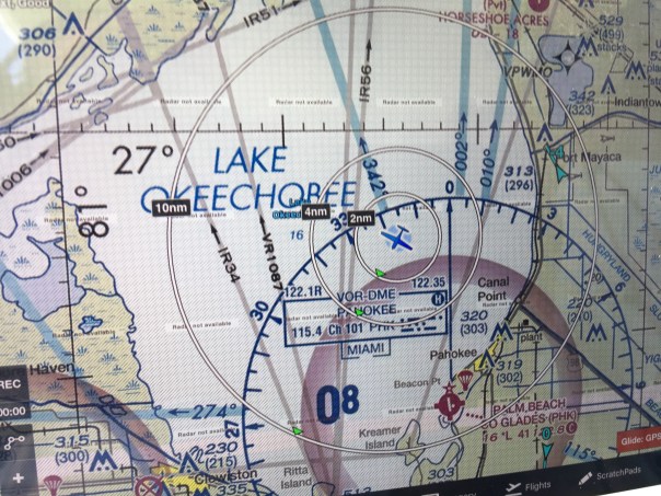
Lake Okeechobee. 11.70 feet.
The South Florida Water Management District and Army Corp of Engineers report Lake Okeechobee’s submerged aquatic vegetation, SAV, is really expanding the sun can reach the grass; this is fantastic for fish and wildlife and water quality, however the closely diked east side of the lake does not get the SAV benefit as it is too deep; the slight algae bloom reported there last week remains. We must be honest and recognize many people feel the lake is too low, but fortunately, there is little chance of discharges from Lake O to the St Lucie and this is a good thing.
~We must note that today the SFWMD made a call for water conservation as much of South Florida is very dry.
~We most keep in mind that predictions are for an above normal hurricane season. It should start raining in the coming weeks.
~In all situations, we must keep our eye on lake O.
Please see the photos below a water update! JTL
LOOKING BLUE! ST LUCIE RIVER AND INDIAN RIVER LAGOON BETWEEN SEWALL’S POINT AND SAILFISH POINT, AN AREA KNOWN AS THE SAILFISH FLATS. SEAGRASS SLOWLY RETURNING. 4-4-20 JTL/EL

ST LUCIE INLET AS SEEN FROM ATLANTIC

LAKE O

Submerged Aquatic Vegetation has greatly improved in Lake Okeechobee; this is great news. The grasses are located in shallow areas but not along the eastern edge where S-308 opens to the St Lucie. The lake is 730 square miles, topography varies. The lake was reported by the ACOE to be 11.70 feet NVGD on 4-6-20. Areas along the shallow western shore look like below.


 SFWMD WEEKLY ENVIRONMENTAL CONDITIONS REPORT 4-1-20 (IMAGES FROM…)
LAKE OKEECHOBEE’S EASTERN SHORELINE, 5000 FT. THIS SHORELINE WAS DIKED CLOSE IN, THE EDGE IS DEEP SO NO SAV GROWS HERE. 4-4-20JTL/EL.

FPL COOLNG POND EASTERN SHORE, ST LUCIE CANAL or C-44 Canal. S-308 at Lake O. YOU DON’T SEE ALGAE FROM THIS FAR UP. JUST A SHADE OF GREEN.

KISSIMMEE RIVER ENTERS LAKE O. LAND EXPOSED DUE TO LOWER LAKE LEVEL. PRETTY HERE. 4-4-20 JTL/EL.


BUCKHEAD RIDGE


Below: THESE PHOTOS WERE TAKEN THE FOLLOWING DAY, SUNDAY, 4-5-20 ON THE GROUND CLEARLY SHOW BLUE GREEN ALGAE ALONG THE EASTERN SIDE OF LAKE OKEECHOBEE AND THE S-308 STRUCTURE THAT ALLOWS WATER INTO THE C-44 CANAL FOR AGRICULTURAL IRRIGATION.
AT THIS TIME NO WATER FROM LAKE O IS GOING THROUGH S-80 AT THE ST LUCIE LOCKS AND DAM TO THE ST LUCIE RIVER. WE WILL CONTINUE TO REMEMBER THE ALAGE BLOOMS BROUGH ON BY LAKE O IN 2016 AND 2018 AND KEEP OUR EYE ON LAKE O.

EASTERN SHORELINE OF LAKE O ALGAE IS APPARENT! VERY DARK WATERS.


SITTING ON ROCKY SHORELINE OF EAST LAKE OKEECHOBEE, SUGARCANE BURNING BEHIND ME, ANCIENT SHELLS IN HAND. ~Photo Ed Lippisch

WALKING THE EASTERN SHORELINE OF LAKE O (VIDEO)


SHELLS ALONG AN EXPOSED BEACH DUE TO LOWER LAKE LEVEL

BLUE GREEN ALGAE INSIDE S-308 STRUCTURE/C-44 CANAL

INSIDE C-44 NEAR A CULVERT


LOOKING OUT OF THE C-44 CANAL TO OPENED S-308 STRUCTURE FOR BOATS

BACK OF S-308

INSIDE S-308

LOOKING SOUTH WEST, LAKE O. THE S-308 STRUCTURE IS TO THE LEFT OUT OF PICTURE

ED AND OUR GERMAN SHEPHERD LUNA LOOK ON

Thank you to my brother Todd Thurlow for his web site http://www.eyeonelakeo and thank you to my husband Ed Lippisch for being on this journey with me for the past twelve years. Onward!
*Friend Paul Millar shared these photos of S-308 today, 4-6-20 3:30pm, so this post is now very updated. Thank you Paul!


First of all, let’s recognize that we are stressed out enough social distancing due to the coronavirus. Nonetheless, for our waters, we must pay attention on every front. Right now, the St Lucie River and nearshore reefs are absolutely beautiful, and there is not a threat from Lake Okeechobee or area canals as it is not raining very much. Lake Okeechobee is at 11.85 feet NVGD, therefore, the chances of discharges into the St Lucie River are basically none. If another Hurricane Dorian comes this summer, that could be a different story.
SFWMD WEEKLY ENVIRONMENTAL CONDITIONS REPORT 3-25-20
SFWMD WEEKLY ENVIRONMENTAL CONDITIONS REPORT 4-1-20
We know our waters suffer from nutrient pollution overdose. Thankfully the State Legislature under the leadership of Governor DeSantis is now paying attention. It will take some time for the bills passed this past legislative session to bear fruit and some will need to be expanded, but when it comes to our waters we are in a better position politically this year and last year than in recent years.
Nonetheless, we must continue our advocacy and continue to document.
The above Jacksonville Army Corp of Engineers map distributed during the March 31, 2020 Periodic Scientist Call shows how much water is going where from Lake Okeechobee. One can see that water for agricultural irrigation is being sent east into the C-44 Canal via S-308; at 191 cubic feet per second. This is fine, and I hope all the water users get the water they need, but algae blooms in our waters is a concern for me.
ACOE Periodic Scientists Call 3-31-20
So to get tho the point, today I share my husband, Ed Lippisch and friend, Scott Kuhns’ flight photos taken today, April 2, 2020 around 11:00am. The aerials show the beginning of an algae bloom in Lake Okeechobee near the S-308 structure at Port Mayaca (Ed said it appeared much brighter than in the photos) as well as clearly in the C-44 Canal near the FPL retention pond and its structure S-153.
Continuing to fly east, there appears to be no algae at S-80, St Lucie Locks and Dam further down the C-44. Keep in mind, the water that is going into the C-44 canal via S-308 at Lake O, Port Mayaca is not going east through S-80 but being used before it gets that far for water supply in the western part of the almost 30 mile C-44 canal.
~Confusing, I know! The C-44 is long and has multiple abilities.
Here are the aerials, as long as possible, we will continue to document the St Lucie River and Lake Okeechobee.
BELOW: LOOKING EAST OVER LAKE OKEECHOBEE, FPL COOLING POND VISIBLE

BELOW: FAINT GREEN ALGAE CAN BE SEEN NORTH OF S-308 ALONG SHORELINE OF LAKE OKEECHOBEE FROM 2000 FEET.


ALGE NORTH OF S-308 and RIM CANAL LAKE O


BELOW: ENTRANCE OF S-308 AT LAKE O GOING INTO C-44 CANAL


BELOW: S-80, St Lucie Locks and Dam, further east along the C-44 Canal, no algae visible


It’s an honor to present:
“Florida’s Summer of Slime: Stuart and Lake Okeechobee,” photo essay by John Moran, August 2018
I reported last month on the plight of the Caloosahatchee River and its befouled waters flowing from Lake Okeechobee; delivering slime to waterfront neighborhoods in Fort Myers and Cape Coral along the way to the Gulf Islands of Southwest Florida.
Next up on our Summer of Slime photo tour is a visit to Stuart and Lake O… Stuart and environs is a glistening jewel born of water. It may well top the list of Florida cities in shoreline per capita. There’s simply water everywhere. Two forks of the St. Lucie River, the Indian River Lagoon, canals and peninsulas and islands, and the Atlantic Ocean beyond. Stuart is pictured above; below is neighboring Hutchinson Island.

 But it wasn’t Stuart’s reputation for abundant clean water that drew me south from Gainesville with my cameras. In effect, I’ve become a traveling crime scene photographer—and slime is the crime. A devastating outbreak of toxic algae has once again hit the St. Lucie River and the Treasure Coast, fueled by the polluted waters of Lake Okeechobee and the Kissimmee River basin to the north. Damaging headlines trumpet the story to the nation and the world and Governor Scott has declared a state of emergency. It’s déjà vu all over again.
 My hosts in Stuart were water blogger Jacqui Thurlow-Lippisch and her husband, Ed Lippisch.
 Ed took me up for a photo flight in his Piper Cub so I could get the big picture.
 Seen from a small plane at 500 feet, Florida is a beautiful place.
 Here’s Lake Okeechobee and the western terminus of the St. Lucie C-44 Canal. Administered by the U.S. Army Corps of Engineers, the Port Mayaca Lock and Dam has the capacity to discharge 14,800 cubic feet of water per second downstream to Stuart and the St. Lucie River Estuary, 26 miles away.
 Sugar industry representatives say the water coming out of Lake Okeechobee is not the problem and that the algae outbreak in Stuart is primarily caused by Stuart’s own septic tanks and urban stormwater. This claim is contradicted by the extensive algae mats seen along the C-44 Canal between the Port Mayaca and St. Lucie Locks, well upstream from Stuart.
 Lake Okeechobee historically drained south to Florida Bay, not east and west to the Atlantic and Gulf. The C-44 canal was built in 1916 to divert floodwaters to the coast.
 A view of the St. Lucie Lock and Dam, several miles southwest of Stuart. On the day of my photo flight in late July, the dam gates were closed, visibly holding back algae from flowing downstream. Look closely and you can see what some people call The Seven Gates of Hell.
 The St. Lucie Lock and Dam are an integral part of South Florida’s complex web of water management structures, born of an age when the Everglades was reviled as a watery wasteland and America was driven to drain it.
 Below the St. Lucie Lock and Dam, in Palm City and Stuart, you can still find waterfront homes untouched by the algae bloom. But that’s no consolation for the thousands of Martin County residents whose lives are in upheaval once again this summer. The familiar pattern of algae outbreaks is fueled by fertilizer, manure and urban sources of nutrient pollution, including septic tanks.
 All of this is compounded by denial and neglect by elected officials and agencies to whom we entrust the important work of environmental protection and public health.
 Jacqui Thurlow-Lippisch took me on a driving tour of the C-44 Canal from Stuart to enormous Lake O, which is more like a stormwater treatment pond than a biologically healthy lake. “There are toxic algae blooms across the globe, but only one place where the government dumps it on you: Florida,” she says.

 It’s not just the algae from Lake Okeechobee causing headaches along Florida’s east coast; the sheer volume of freshwater discharges is an environmental pollutant that overwhelms the estuary.
 The Lake O gunk visible in the satellite view, above, is shown in the detail photo below.

 Fishermen are still drawn to Port Mayaca. On the day we visited, I counted nine.
 Dinner in hand (speckled perch), Felix Gui, Jr. has been fishing Lake O for 30 years. “The algae doesn’t affect the fish,” he says. “They eat the same, algae or no algae, and I haven’t gotten sick.” Experts have warned against eating fish exposed to the algae.
 A Martin County Health Department sign at Port Mayaca warns against contact with the water but I saw no messaging about whether fish caught in these waters is safe to eat.
 Enroute home to Stuart, Jacqui and I stopped at deserted Timer Powers Park on the St. Lucie Canal in Indiantown.
 At the St. Lucie Lock, a surreal scene of impaired water, above, and a vortex of slime, below, waiting to be flushed downstream.

 A pair of jet-skiers signaled for the lock to be opened, and another pulse of algae-laden water is released towards Stuart and the coast.
 Wouldn’t want to anyway, thanks.
 Further downstream, the algae spreads…
 Nearing the coast, Rio Nature Park and the neighboring Central Marine in Stuart are slimed again. This was the epicenter of the infamous Treasure Coast algae outbreak of 2016.


 Reporter Tyler Treadway of TCPalm gathered a sample of the polluted water from a canal behind the offices of Florida Sportsman magazine in Stuart.
 Staff complaints of headaches, nausea and dizziness prompted Florida Sportsman publisher Blair Wickstrom to temporarily close the office in late July. “It smells like death,” he said.
 The Shepard Park boat ramp parking lot in Stuart was nearly empty on the day we visited.

 A man on a mission, Mike Knepper, above and below, posts videos on his Youtube channel documenting the degradation of natural Florida.
 “It’s totally unacceptable to me what we’re doing to this planet because we’re very rapidly destroying it,” Knepper says. “My children and grandchildren will be paying the price for all the bad decisions we’re making today. I want to be able to look them in the face and say, ‘I tried to make a difference.’”
 Dead-end canals along the St. Lucie River with their limited water exchange have been hardest hit by the toxic blue-green algae, which scientists refer to as cyanobacteria.
 A growing body of medical research links exposure to cyanobacteria with neurodegenerative diseases including Parkinson’s, ALS and Alzheimer’s. Google it.
 Meanwhile, we’re getting conflicting messages from officialdom. Martin County has erected signs warning against contact with the water but the Florida Dept. of Health website, under the heading How to Keep Your Family Safe While Enjoying Florida’s Water Ways, has this to say: “Cyanobacteria/ blue-green algae…are naturally occurring in Florida’s environment and are also found all over the world. They are part of a healthy ecosystem and help support a wide variety of aquatic life.” (http://www.floridahealth.gov/environmental-health/aquatic-toxins/cyanobacteria.html) In other words, Lighten up, Florida. This is just nature being natural.
 An open question remains: What will become of the value of the Florida brand when the world fully sees what we have done to our waters?
 Even in disaster, strange beauty emerges.
 Greg Fedele has lived in his water-front home since 1991. He grieves for his loss. “I have three kids who can’t enjoy the waterways of Martin County like I did growing up.”
 The sign at Ocean Blue Yacht Sales in Stuart echoes a wide swath of community sentiment. Asked to describe in a word how the algae outbreak has impacted his business, president Bryan Boyd replied, “Horrible. The last three years, our bay boat sales have been a third of what they used to be.”
 A roadside sign seen in Stuart in late July. If you’re wondering what you can do about the ongoing crisis of Florida waters, we are called to consider our own water footprint, learn about the issues and get involved. And never forget that elections have consequences. Vote for Clean Water. (https://www.bullsugar.org/#)

What we have here in Florida is not just a crisis of water, we have a crisis of democracy and civic engagement.
From the beleaguered springs of North Florida to the sickened rivers and coasts of South Florida, we must understand that no savior is waiting on the horizon who will fix this thing for us.
It took a group effort to create this mess and we need all hands on deck if are to reclaim our waters. Florida needs environmental patriots willing to face down politicians funded by wealthy interests who think nothing of sacrificing our public waters on the altar of their private profits.
We don’t have the luxury of time to get this right. We are losing our waters now. This is our moment. It’s time to set aside our differences and focus on what is at stake, for this is nothing less than a battle for the soul of Florida.
The pictures don’t lie. We the people of Florida bear witness today to nothing less than a crime against nature, and a crime against the children who shall inherit our natural legacy.
A long time ago, Florida political leaders—Republicans and Democrats in common cause—understood there can be no healthy economy without a healthy environment. They wisely enacted laws and regulatory safeguards accordingly.
But that was then and this is now. It’s time to end the popular fiction in Florida that we can plunder and pollute our way to prosperity.
Gov. Reubin Askew said it best when he declared in 1971, “Ecological destruction is nothing less than economic suicide.”
In this, our Summer of Slime, can I get an amen?
by John Moran
August 2018
web: http://johnmoranphoto.com
email: JohnMoranPhoto@gmail.com
cell: 352.514.7670
Feel free to forward or post this photo essay as you wish; attribution is appreciated. Please share this with elected officials and ask them: what’s their plan to clean up our waters?
6-24-18, (Sunday)
I am posting this, not because I want to but because I have to. I much rather be enjoying the day instead of once again sitting at my computer. But time is of the essence.
This morning I read a comment by TcPalm reporter, Ed Killer, on Facebook stating the ACOE’s pulse release schedule for the St Lucie River.
Ed KillerThe Corps gave me this today
Sat- 0
Sun- 0
Mon- 1270 cfs
Tues- 2000
Wed- 2100
Thu- 1650
If this is true, and with Ed Killer posting, I believe it is, the ACOE will start releasing again Monday, 6-25-18. I did not know this until I read his post.
Today, my husband Ed and I were flying other people over Florida as usual, and during our flight I took this video expecting maybe some algae in C-44 but instead also found the gigantic bloom against the gates of S-308 in Lake Okeechobee leading into C-44/SLR.
So I wrote on Facebook:
I am so over this, but cannot fail to report. According to Ed Killer ACOE will start discharging from Lake O tomorrow in spite of Governor’s Emergency Order. Look at this algae mess waiting at gates of Port Mayaca. Write ACOE’s LTC Jennifer Reynolds and politely ask for ACOE to wait and to have DEP test again: jennifer.a.reynolds@usace.army.mil (JTL-S-308 video taken 6-24-15 at 12pm) #toxic2018
As Monday is tomorrow, and I fly to DC with the River Kidz tomorrow, I am posting this now. I truly believe considering the circumstances, that the ACOE should refrain from discharging at S-308 or S-80. And the state’s FDEP (Florida Department of Environmental Protection) should have this water tested, again, as bloom has changed.
To just dump this on the people of Martin County along the St Lucie River is a crime.
Respectfully,
Jacqui
PLEASE WATCH THE VIDEO


 Entrance to Caloosahatchee on west side of lake and near Clewiston Bloom is all through lake.


“The FPL Reservoir’s Catastrophic Dike Failure”
Barley Barber Swamp, the FPL Reservoir and its 1979 Catastrophic Failure (Part 2 of 2), Todd Thurlow, SLR/IRL

Video link “The FPL Reservoir’s Catastrophic Dike Failure” (https://youtu.be/2r1hgFqgIK8)

On Halloween eve, October 30th 1979, the southwest side of the dike embankment at Florida Power & Light Company’s Martin Plant suddenly, and without warning failed catastrophically.
It was the dead of night and certainly the creatures of the nearby Barley Barber Swamp sensed more than their human masters. No person saw the incident. There were no cameras, no guards, no witnesses. It was the 1970s.
We can imagine, though, even though the final report said “not,” that for months sands had been slipping, eroding underground, perhaps led by connection to the old borrow pits dug for the railroad that came through in the 1920s.
My brother Todd’s latest spectacular time capsule flight takes us through this fateful night that by the time Halloween arrived, derailed a southbound train. The conductor reported the incident to his superiors as a “flash flood.” It was eventually realized that this flash flood was part of something much larger in scope!
Even if you know the story, the numbers are staggering…
As Todd notes, when the dike let loose, 100,000 cfs of water (cubic feet per second) blew into L-65, the canal on the edge of the FPL reservoir, and into the C-44 canal connected to the reservoir at S-53. The biggest numbers we hear these days in cfs is about 5000.
Facing west, a wave surged over the sugarcane fields and overtop US 441, traveling north seven miles in the rim canal. S-308 at Port Mayaca flowed backwards, and 4000 cfs entered Lake Okeechobee.
The finally alerted ACOE maxed S-80 at St Lucie Locks and Dam at 15,800 cfs, (over twice the highest amount of the Lost Summer of 2013 at 5700+/-). Crazy! Todd says the max for S-80 into the St Lucie River is 16,900 cfs. Not too far off were they.
Of course, these peaks would have only been for a few hours, but nonetheless, as is often the case, these kind of numbers mean “instant death for the St Lucie.”
This FPL event traveled much further north than the C-44 canal though; the last paragraph of the SFWMD 1980 report’s “failure section” notes:
“The Rim Canal reached a peak the next day (November 1) at the north end of the basin, 17 miles from the St. Lucie Canal. The flood was contained at this northerly point by the Nubbin Slough Tieback Levee along Canal 59. The maximum area flooded, was about 14,100 acres.”
What a story!
Well, it’s only history, right? But then history has a strange way of repeating itself in one form or another doesn’t it?
WATCH Todd’s VIDEO HERE: “The FPL Reservoir’s Catastrophic Dike Failure” (https://youtu.be/2r1hgFqgIK8)

Links:
Interim Final Draft Report on Embankment Failure FPL’s Martin Plant Cooling Reservoir, SFWMD, 1980: http://damsafety.hostguardian.com/media/Documents/DownloadableDocuments/MartinPowerPlantFailureReport.pdf
Palm Beach Post, Post Time, FPL 1979 Dam Collapse Hit Martin County, Elliot Kleinberg :
http://www.mypalmbeachpost.com/news/local/post-time-1979-fpl-reservoir-dam-collapse-hit-western-martin-county/2BU5WcnUVTz9GGNAhTSEGK/
Read part 1 of this FRL series below:
Part 1, Barley Barber Swamp, the FPL Reservoir and its 1979 Catastrophic Failure (Part 1 of 2) Todd Thurlow/JTL: https://jacquithurlowlippisch.com/tag/barley-barber-swamp/

7-6-23
My mother came across this photograph in her files. She says it was labeled “Stuart News. Remarkable. JTL

“
Recently, it seems to rain almost every day!
TCPalm’s Elliott Jones reported this morning that Stuart has received a whopping 11.30 inches of rain just so far this month! (The average being 7.14.)
Although due to the recent drought, the ACOE/SFWMD are not dumping Lake Okeechobee through Canal C-44, canals C-23, C-24, C-25, and areas along C-44, as well as our own basin, are draining right into the St Lucie River/Indian River Lagoon. Very little of this water is cleansed before it enters and thus is damaging to the eco system. Next time you see water draining through a grate in a parking lot, think about this. Remember too that before the major canals were constructed the 1900s, the river received less than half the water it gets every time it rains today.


The aerials below were taken 6-13-17 by my husband Ed Lippisch and pilot Dave Stone. It is important to monitor the river all of the time so we can view changes.
“Rain stained” we are; please remember not to fertilize during the rainy season. The birds on Bird Island will appreciate it! (http://befloridian.org)


Canals draining water into SLR/IRL after rain events:
C-23 http://www.dep.state.fl.us/southeast/ecosum/ecosums/c23.pdf
C-24 http://www.dep.state.fl.us/southeast/ecosum/ecosums/c24.pdf
C-25 http://www.dep.state.fl.us/southeast/ecosum/ecosums/c-25.pdf
C-44 http://www.dep.state.fl.us/southeast/ecosum/ecosums/C-44%20Canal%20.pdf

The past two days, I feel like I have been a guest on the TV series “Storm Chasers,” except I have been running from the storms.
Yesterday, I decided I really needed to go look at Lake Okeechobee myself to see the toxic algae bloom that has been reported through social media, TC Palm, and the internet. –The algae bloom that inspired Senator Negron to ask Col. Dodd of the ACOE to refrain from opening the gates, which they did not do. On Tuesday’s, at 2:00 PM, are the Army Corp of Engineers’ “Periodic Scientist Call for Lake Okeechobee” of which I have participated in for almost three years…
“Perfect,” I thought, “I’ll go to the lake for the call a bit early and take some photos. I will be out in Palm City around that time anyway; it’s really not that far…” The drive is about 20 miles.

In spite of the previous day’s inclement weather, I had not checked the weather closely as I can never figure out how to get radar maps on my phone. Not checking the weather, turned out to be a big mistake.


Around 1:00 PM, as I approached Port Mayaca going west along Highway 76, suddenly grey clouds in the distance converged overhead spilling out over the sky like black oil. Huge bright lightning bolts struck the ground in the direction of the lake, thunder followed almost immediately; rain dumped out of the sky. …”Oh no, not again…” I thought.
The winds screamed across the landscape. Large trucks coming towards me in the opposite direction splashed wakes hitting my car full force. Eventually, I pulled over at the entrance of DuPuis Wildlife Reserve;” the water was rising on the dirt road. Looking at my surroundings, I realized I was next to the Port Mayaca graveyard where thousands of people were buried in a mass grave after perishing in the 1928 hurricane. I turned on the radio, my windshield-wipers whipping back and forth. The unnerving sound of the Emergency Broadcast System blared and a calm computerized voice said: “Tornado warning for western Martin County.” Shaking, I forced my self to try to find radar on my phone. I found a written tornado warning for Indiantown. I was at ground zero.
All alone with the elements, I wondered what possessed me to do such a thing….I closed my eyes…I prayed…
Within thirty minutes the storm had passed. Thankfully it was not my day to die. I shook off my fear, got my self together, and completed my drive to the lake. This is what I found:


The lake seemed oddly calm after such rage. You could hear a pin drop. I looked around…
Storms tend to break up algae blooms, but under the right conditions of heat and over nitrified water (over-fertilized basically), they come back. In my opinion, this toxic algae issue really forces us all, from the public, to city government, to the office of the Governor, to the state legislature, to the President of the Untied States, and Congress, to ask ourselves the most critical of questions.
“Is it legal for a federal agency to knowingly release toxic water into a local community?”
To me this is situation is different than a toxic algae bloom simply forming in a localized body of water. What we are talking about here is toxic algae being purposefully transferred from one body of water to another, by the government no less…This seems wrong. Un-American.
Then of course there is the other issue, flooding south and around the lake. As I experienced yesterday, things happen very fast around this giant lake, this “big waters,” this Lake Okeechobee.
Take a look again at the first photo I show of S-308 from the bridge. This photo gives perspective of how fragile this dike and structure-gate system is. It is like trying to hold back an ocean with a cement wall. There has got to be a better way to keep our families, healthy and safe….
______________________________
Learn about toxic algae blooms: (http://en.wikipedia.org/wiki/Algal_bloom)

Yesterday, a blue-green algae bloom was documented at S-308 just east of Lake Okeechobee/C-44 Port Mayaca, by Kenny Hinkle and Mike Connor: (https://www.youtube.com/watch?v=c7CglO2z33E&spfreload=10)
You hear it all the time, and it most things considered, it makes sense: “Flood control…”
The Army Corp of Engineers and South Florida Water Management District “HAVE TO” dump from Lake Okeechobee because when its waters are “too high,” it endangers the people and the farms south of the lake.
But what about us? What the thousands of people who live, fish, and boat along our estuary? Are we protected?
Blue-green algae, cyanobacteria, produces two groups of toxins, neurotoxins and peptide hepatotoxins. Great. Is this what our government should be releasing into our waters? This is a fresh water bacteria and it comes from the lake not the brackish estuary. But after our estuary has been “dumped on” by all the area canals, with an overabundance of fresh water, or an overabundance of water from the lake, the microcytosis can live here!
Disgusting…
Let’s think about this.
The first responsibility for any government is the “health, safety and welfare” of its people. That is my responsibility as an elected official in the Town of Sewall’s Point.
So when circumstances are as they are today, or at least yesterday–and there was documentation of what clearly appears to be a blue-green algae bloom, most likely toxic, on the eastern side of Lake Okeechobee at S-308, am I supposed to remain quiet? I think not, and nor should you.
The ACOE is scheduled to start dumping today. I admit, that the ACOE, SFWMD, governor, and legislature are in a difficult position having to protect one group at the expense of another, but somebody better figure it out.


__________________________
The dumping of blue-green algae in Lake O waters is what led to the toxic “Lost Summer” of 2013, and the fish kills and toxic waters of 2005 in the SLR/IRL.
Microcystis: (http://en.wikipedia.org/wiki/Microcystis_aeruginosa)
ACOE: (http://www.saj.usace.army.mil)

With all the fanfare of President Obama’s visit and the confrontation that seems likely at the April 2nd SFWMD, Water Resources Advisory Board meeting between “Stop the Land Grab” (http://goo.gl/2YVLXT) and the River Warriors, it is important to keep our “eye on the ball.” THE RIVER.
Since January 16th of 2015, the ACOE and SFWMD have been overseeing the releases from Lake Okeechobee into the St Lucie River/Indian River Lagoon. (The ACOE technically oversees this; however, collaboration includes the science of both agencies.)
January is very early to start releases, but the lake “is high” for this time of year. Due to releases and evaporation, it is slowly going down and now at 14.04 feet. The goal 13.5 (?) or so, but they won’t say that because one must “be sensitive to water supply” for agriculture and other users…(http://w3.saj.usace.army.mil/h2o/currentLL.shtml)
Today, I will share photos by my husband, Ed Lippisch, that were taken yesterday around 5pm during the onset of an incoming tide. Ed was piloted by friend Scott Kuhns. Thank you Scott and Ed! 🙂
As mentioned in an earlier blog, the ACOE is PULSE RELEASING and lowering releases into the SLR through S-80 right now in an attempt to help Martin County evaluate bacteria testing that cannot be done during heavy discharges. It is interesting to note that pulse releases mimic nature so that the estuary is not continually pounded, and can recover a bit. Just like during a rain event, the water flow is intense, salinity drops, and then salinity increases when the water lets up. You can see the schedule below.

One of the most interesting photos is of Sailfish Point’s marina where the runoff into the SLR/IRL is very apparent. There is always runoff from land into the rivers, yet we must remember the rain takes everything on the land with it: fertilizer, pesticides, herbicides, loose sediment….Martin County’s strong fertilizer ordinance rules don’t begin until June 1st, so it is likely that this runoff is full of pollution that like releases from Lake Okeechobee or area canals is not good for seagrasses.
For me the aerials of the seagrasses are most depressing. The once healthy beds look horrible. One can see they have algae all over them . Maybe I’m hyperbolizing, but the seagrasses do not look good to me. Having grown up here and swam in these area waters as a kid when they were lush and full of life—-the present condition is not acceptable.
Anyway, let’s keep our eye on river and we move through all these politics, and here is a look from above at YOUR RIVER!


ACOE excerpt —Info that goes with the above pulse release schedule; it is from 3-26-14. Another will call will occur today and updates will be considered.
UNCLASSIFIED ACOE
Caveats: NONE
“Based on the current lake levels, tributary hydrologic conditions, and multi-seasonal forecast, 2008 Lake Okeechobee Regulation Schedule (2008 LORS) Part D guidance is up to 3000 cfs at Franklin Lock and Dam (S-79) and up to 1170 cfs at St. Lucie Lock and Dam (S-80). We have considered stakeholders input and recommendation from the South Florida Water Management District.
The U.S. Army Corps of Engineers Jacksonville District will be continuing discharges at S-79 at the same level as last week. However, the target discharges are reduced at S-80. The target flows over a 7-day period will be an average of 2500 cfs at S-79 and 500 cfs at S-80 cfs. These discharges will be made in a pulse-like manner (see attached).
These releases will start Friday, 27 March 2015 at 0700 hrs and end on Friday, 03 April 2015 at 0700 hrs.”
________________
ACOE Jacksonville: ((http://w3.saj.usace.army.mil/h2o/currentLL.shtml))
SFWMD: (http://www.sfwmd.gov/portal/page/portal/sfwmdmain/home%20page)

Today I want to share what I consider a huge recent success of the River Movement and our ability to network and work together to protect our St Lucie River/Indian River Lagoon.
On August 25th, Jensen Beach activist Jackie Trancynger sent out an email blast featuring a photograph taken by Paul Shidel of an awful looking algae bloom he found while photographing birds at Port Mayaca. Port Mayaca is where structure S-308 is located that allows water from Lake Okeechobee to be released into the C-44 canal to the St Lucie River/Indian River Lagoon.
Here’s the photo. You may recall reading about it in one of my previous blogs or seeing it in an email exchange:

So anyway after I saw the photo, I called Jackie Trancynger and got Paul Shidel’s email in order to verify the location of the bloom-certainly appearing to be toxic algae. Paul not only verified the location but provided a map!

On Tuesday, August 26, I participated as I have for almost two years now, in the ACOE Periodic Scientists Call in my capacity as an elected official from the Town of Sewall’s Point at the invitation of Ms Deb Drum, who oversees Martin County’s Ecosystem Restoration & Management Division.
During this call I sent Paul’s photo and map to the ACOE stating concern that if S-308 were opened this possibly toxic algae would head straight into our SRL/IRL.
Then an amazing thing happened..
The ACOE ask the Department of Environmental Protection (DEP) to test the algae.
Yesterday, Deb Drum from Martin County reported that the testing came back positive as “Microcystis, a toxic blue-green algae.” The county in turn notified the ACOE that the algae exists in that location to document their concern. If the ACOE were to open the locks at S-308, the algae could travel downstream with the water flow into the SLR/IRL. This knowledge could actually make a difference in a decision of the ACOE to open up those structures.
Wow. Thank you Paul!
I have complained before on the ACOE call about toxic algae being released from Lake Okeechobee as the SLR/IRL does not seem to “go toxic” from its local canals, but only when Lake Okeechobee’s waters are unleaded to our shores. Toxic algae has been seen in the area between S-308 and S-80 many times but we need to start documenting this. Documentation is a powerful tool in changing the tide of destruction.
So thank you for your teamwork! Together we can help KEEP THEM CLOSED! The “Gates of Hell” that is…
____________________________________________________________________
REPORT:
Subject: Lake Okeechobee, Okeechobee/Glades/Hendry/Palm Beach/Martin Counties: Florida CyanoHAB Tracking Module has received a record update
On August 27, 2014, Florida Department of Environmental Protection’s Southeast District staff sampled an algal bloom found in Lake Okeechobee. A single grab sample was collected of surface scum at the Port Myakka Lock (C-44.) Following are the laboratory results for this sample:
Result:
Class
Toxin potential *
The dominant taxon was:
Microcystis aeruginosa
Class Cyanophyceae
yes
Other taxa present:
Dolichospermum circinale **
Class Cyanophyceae
yes
Pseudanabaena sp.
Class Cyanophyceae
undetermined
Eudorina elegans
Class Chlorophyceae
–
Pediastrum simplex
Class Chlorophyceae
–
Glenodinium sp.
Class Dinophyceae
* Information based on literature searches and personal communications; information is continually being updated. “Undetermined” refers to specimens for which the lowest practical level of taxonomic identification is genus and some, but not all, species within that genus have the potential to produce toxins or toxin information not available for the identified species but is available for genus level.
** Dolichospermum circinale (synonym = Anabaena circinalis)

Does the above photo make your stomach turn? What is it?
It is a HAB or Harmful Algae Bloom, taken four days ago, right here in Martin County.
According to the United States Department of Agriculture, “over the past century, alterations of land use and acceleration in the rate of cultural eutrophication have led to widespread increases in harmful algal blooms in Florida, including toxin-producing species.”
First, what is “eutrophication” and why is it “cultural”?
Eutrophication is is when a body of water becomes enriched in dissolved nutrients (such as synthetic phosphorus and nitrogen from fertilizer) that stimulate the growth of aquatic plant life usually resulting in the depletion of dissolved oxygen and a “bloom.” These algae blooms can be toxic.
“Cultural means “created by humans.”
So what are we doing about this especially since “we” caused it?
In 1997 the Florida Department of Environmental Protection formed a Task Force on Harmful Algae Blooms and in 1999 they produced a scientific document, a White Paper: HARMFUL ALGAE BLOOMS, (http://myfwc.com/media/202228/HAB_whitepaper2006_UPDATE.pdf) It is extensive.
In my opinion, as usual, our state governors and legislatures did not pay significant attention to these studies, and failed to implement policies that would help overcome this crisis issue. How many of them even read the report?
Case in point, recently, it was the local governments and local residents of the towns, cities and counties along the west and east coasts of Florida who advocated and achieved strong fertilizer ordinances not allowing fertilizer use during the rainy season while the state continues to fight and support less restrictive rules.
According to the Florida Fish and Wildlife website there are four ongoing studies regarding HABs in Florida: (http://myfwc.com/research/redtide/research/scientific-products/)
1. Time-Series Sampling in Pinellas and Manatee Counties) Researchers conduct detailed sampling to better understand when, where and under what conditions harmful algal blooms form.
2. Tampa Bay Monitoring Program Researchers monitor 10 sites in Old Tampa Bay for the presence of, or conditions favorable to, harmful algal blooms.
3. Red Tide Offshore Monitoring Program
Encouraging people to learn about the program and learn how to become volunteers, collecting water samples around the state to help scientists monitor the Florida red tide.
4. Monitoring Toxic Algae Species and Shellfish in the Indian River Lagoon (2002-present)
Periodic testing of water samples and clams provides an early warning of bloom occurrences and shellfish toxicity and minimizes the risk of human exposure to saxitoxins.
Those are great present HAB programs, so why don’t we hear more about them and why don’t they include Lake Okeechobee, obviously the toxic algae is there as well…
Here at home, when the gates of S-308 open from Lake Okeechobee to the C-44 canal that is connected to the St Lucie River/Indian River Lagoon, the algae in the photo above goes directly into the our river system.

It is 2014. The state has been studying this problem since 1997. They do not have all the answers but we do know by now that HABs are fed by cultural eutrophication due to clearing of land that can no longer clean water on its way to estuaries, rivers and lakes; building of towns and cities that create concrete and asphalt barriers to water reabsorption; fertilizer and other runoff; oil/chemicals from thousands of miles of highway and roads; septic effluent; canals and redirection of water such as Lake Okeechobee to the St Lucie and Caloosahatchee; agriculture’s heavy destruction of native lands and the fertilizer and chemical runoff associated with their business, unregulated golf courses fertilizer run off and re-use of high nutrient water resources….it’s endless.
It is said that “ignorance is bliss,” well the state of Florida doesn’t have that luxury anymore.
Blue Green Algae. (Public photo.)
___________________________________
USDA HABs: (http://www.reeis.usda.gov/web/crisprojectpages/0209332-harmful-algal-blooms.html)
FWC HABs: (http://myfwc.com/research/redtide/general/harmful-algal-bloom/)


The locks are back in the news again. WPTV, “hard working for the river reporter,” Jana Eschbach, broke the story yesterday, that the Army Corp of Engineers did not alert the public that they would be releasing polluted canal, C-44 basin water through the S-80 structure into the St Lucie River. Jana, like most people, feels that the public should be alerted when polluted water will be coming into the estuary in that we swim and fish. She is also concerned the water in the area of Palm City and the Roosevelt Bridge, which has been reported to have high levels of bacteria, will be pushed to the popular Sandbar area.
This can be confusing. Don’t we just care about lake water? Also, if the locks are open, doesn’t that mean the ACOE is releasing Lake Okeechobee water? Not necessarily, and the basin water can be just as damaging to the estuary and the public. So how does releasing basin or lake water work?
There are two structures along the C-44 canal which runs along the side of Highway 76 from the South Fork of the St Lucie River, to Lake Okeechobee: S-308 at the edge of Lake Okeechobee, and S-80, 20 miles or so, east, at the St Lucie Locks and Dam.

S-80 serves duel purposes. First to release water through Lake Okeechobee, but only if S-308, at the lake, is open first, allowing water into the C-44 canal. Then S-80 lets the water pour into the St Lucie River.
Second, S-80 can be opened just to allow water from the C-44 to flow into the St Lucie River, as the C-44 canal is surrounded by a 185 square mile basin, mostly agriculture, that has been directed to flow into the canal when it rains. Agriculture also uses this water in the C-44 canal to water their crops. To make things more confusing, C-44 can “deliver” local basin runoff in both directions: to Lake Okeechobee and to the St Lucie Estuary. The ACOE decides where the water “needs” to go by opening and closing the structures of S-308 and S-80.
It must be noted that the water from the C-44 basin is polluted, as is the water from Lake Okeechobee. The Florida Department of Environmental Protection writes: “…the construction of the C-44 canal has had the greatest impact of the St Lucie Estuary–and nearly all of that impact has been bad, FDEP 2001.) The charts below show how much nitrogen and phosphorus come into the river from the C-44 and other basins. C-44 is the highest. Phosphorus and nitrogen mostly from fertilizer, feed toxic algae blooms in the hot summer months.


Fortunately, there is good news due to the help of our local, state and federal governments. The almost 3 billion dollar “C-44 Storm Water Treatment Area/Reservoir” has received first stage fundings and is under construction in Indiantown. It has been since 2011. This reservoir will hold the release water from the C-44 basin and clean it before it is returned to the St Lucie River. This is a huge positive, although it will not stop the releases from Lake Okeechobee.
An educated public is the best defense against the continued destruction of the St Lucie River/Indian River Lagoon. Thank you for being part of the solution and hopefully, next time, the ACOE opens any structure for any reason, they will alert the public, because here in Martin and St Lucie counties, we want to know!
________________________________________________
Cool video SFWMD C-44 STA/R. (https://www.youtube.com/watch?v=4BsC0BoIPJ4)SFWMD (http://www.hdrinc.com/portfolio/c-44-reservoir-stormwater-treatment-area-project)
FDEP C-44 Canal: (http://www.dep.state.fl.us/southeast/ecosum/ecosums/C-44%20Canal%20.pdf)