Growing up in Stuart in the 1970s, my mother and father gave me full reign to explore the undeveloped lands in the area of St Lucie Estates. I remember endless summers, wandering around in “the woods” and of course my eyes were drawn to the vine of the widely dispersed, perfectly shaped, red and black seeds known as rosary peas.
I would collect them tightly in my little, sweaty hands, pushing them far down into my pockets. I recall the first time I brought them home, my mother said, “Yes, they are very pretty, but don’t eat them, they are poisonous.”
“Hmmm,”I thought. “How can something beautiful be poisonous?”
I continued to collect the seeds, and over the years filled up many clear glass bottles that sat in my window sill; the sun never fading their brilliant color.
Later in life, I learned that bright color patterns, especially red, black, and yellow, as with some caterpillars, or the famous, shy, and deadly coral snake, are “warnings” in nature and actually provide the animal with protection from being eaten.
As I walk through Hawk’s Bluff today, I am thankful to my parents who allowed me to explore the natural world and grow confident, unafraid, even with all of its toxic beauty.
4th Street/East Ocean Blvd 1957, Stuart, Florida, Arthur Ruhnke. Courtesy archives of historian, Sandra Henderson Thurlow.“See that white strip just below the wetland? That is the extension of Flamingo Drive that skirts the pond behind the old car wash. They just dug a retention pond and conducted the water to it. All of that pineland is covered with condominiums today.” (Cedar Point, Vista Pines, and Kingswood)~ Sandra H. Thurlow
Today we drive over the Indian River Lagoon and St Lucie River surrounded by “civilization,” and forget that once it was once a wetland and pine forest full of wildlife. In the course of a lifetime, these things are long forgotten.
The above 1957 photograph hangs in my brother’s law office. When I visit him, I find myself staring at it for long periods of time. It is one of those rare photos that really puts things into perspective. The road construction through the wetlands, (note it going through the pond, and pine forest) was all taking place around the same time that the “Bridges to the Sea,” from Stuart to Sewall’s Point, and Sewall’s Point to Hutchinson Island, were completed. It’s amazing to see what the landscape once looked like. The road in the photograph, Fourth Street, was renamed “East Ocean Boulevard” in 1960, and is a major thoroughfare to the beaches today.
Jenny, Todd and I 1973, alligator in background.I remember early East Ocean Blvd, although it was already quite changed by the time I was born in 1964. My family lived at 109 Edgewood Drive in Stuart, a short distance away from these wetland ponds under development. I recall Scrub Jays in our back yard and feeding them peanuts. By 1974 the family moved across the river to Sewall’s Point “growing and improving” with the changing landscape.
By 1979, when I was fifteen years old, riding my bike over the bridge to Stuart to work at the Pelican Car Wash, the beautiful wetland pond had been relegated to a retention pond for run off. Over the next two decades, you didn’t see wetlands and ponds anymore, or wildlife, just condominiums, office buildings, and shopping plazas. The state four-laned East Ocean Boulevard and built higher bridges to the ocean too.
Believe it or not, the pond in the aerial is still located behind a gas station that used to be the car wash. It is not even a shadow of its former self. Two days ago, I drove by and noticed that there was an extensive algae bloom in the pond backed up to the parking lot and gas pumps; the water reflecting a sickly shade of green.
I sat there thinking about the long forgotten pond in the middle of East Ocean Boulevard in the photo I love in my brother’s office, wishing the developers had figured out a way to go around the pond. As the shortest distance between two points, over time, is not always a straight line.
East Ocean Blvd 1957, courtesy historian, Sandra Henderson Thurlow
Flamingo and retention pond at Flamingo and East Ocean 2017, once a wetland.Google map of East Ocean Blvd. through what was once wetland and forest, 2017.1940s Dept of Agriculture photographs of Martin County showing wetlands. Courtney Todd Thurlow and UF archives.Overlay 1940 aerials over Google map today, Todd Thurlow.USDA History of Wetland Development in Florida: https://www.nrcs.usda.gov/wps/portal/nrcs/detailfull/fl/newsroom/features/?cid=stelprdb1252222
Rand’s Pier being built in 1957; the pier was built out 400 feet into the Atlantic. I visited the pier often through the 60s-80s growing up in Martin County. Photo Sandra Henderson Thurlow archives.Aerial of Seminole Shores. Thurlow Archives, ca. 1950s.
I think it is typical to think the time one grew up in was the “best of times,” but I feel mine really was…
One of my fondest memories of growing up in Stuart is visiting Rand’s Pier at Seminole Shores on Hutchinson Island. This area became today’s Sailfish Point. Tromping through the hot sands, my mother would lead my brother, sister, and I down a long, winding, sand-spur/beach-sunflower covered path. Finally, we would arrive at our destination, a pier that would provide shade and shelter for the outing.
From here my brother, sister, and I would take our buckets and nets and catch baby fish, collect shells and sea glass, or dig holes and bury each other up to our necks.
The pier was a reference point for a time past, and man gone, who my mother said was famous. The man was James Rand Jr. of Rand Ledger Corporation decent who went on to build his own fortune. An impressive eccentric, a Harvard graduate, with his share of troubles—but always a gifted business man— he did many wonderful things for Martin County including becoming a benefactor to the hospital and helping found and fund the Florida Oceanographic Society. Although it was not to be his fate, he had dreams of fully developing what was then known as Seminole Shores—-today’s Sailfish Point.
According to the History of Martin County: “In the early fifties James Rand acquired part of what was known as Seminole Shores on Sailfish Point three miles south of the House of Refuge. It was his intension to develop the area with exclusive residences, a marina, a clubhouse, cabanas, and a restaurant. He built the marina, the clubhouse and yacht basin, laid out and paved a number of streets, and built some thirty cabanas in a semicircle around a swimming pool, facing the ocean that one might take advantage of either fresh or salt water bathing. He also put in the telephone lines for the south end of the island at a cost of approximately $15,000…”
When my siblings and I were running around we did not think much about the man who built the pier, or put in the telephone lines, or helped make the island accessible for us to play. But his name always stuck in my head as someone who had made a difference to Martin County. The years have passed and Martin County has changed.
Today, Sailfish Point is beautifully developed– certainly beyond what Mr Rand would have ever imagined. The pier? Time tide and time have taken it: it has washed away– But when I walk the beach I still look for it and remember the “best of times”…
Remaining pier 2009. (Photo JTL)My husband Ed under the pier in 2009. The entire pier washed away a few years later after a great storm. (JTL)Beach sunflowers…(JTL)
Blue sea glass. (Photo via “West Coast Sea Glass.”)
One of my favorite childhood memories is searching for sea glass along our beaches, on the other side of the Indian River Lagoon…
My parents’ friends, the Nelsons, were one of the first to build “out there,” on Hutchinson Island; I would often spend the night with their daughter Lynda. Lynda and I would wake up in the morning before dawn, climb the stairs to the roof, and wait for the sun to rise. Like yellow gold, it would emerge over the ocean, and we would begin our treasure hunt for sea glass.
In those days, in the late 1960s and 1970s, our Martin County beaches were not “renoursished,” and if you picked the sand up in the palm of your hand, it was beautiful and consisted of thousands of little crushed shells of every imaginable color….often a piece of sea glass would be there too.
Lynda and I had baskets her mother had given us, and on any given weekend we could fill a small basket full with glass. The most common color was brown, then green, then clear, and the rarest of all was blue! Blue was the prize. Blue was goal…Lynda always won!
Sea glass comes in many colors. (Photo via “Odyssey Sea Glass.”)Sea glass rarity color chart. (Image via “Find Sea Glass.”)Along the beach, Jupiter Island, 1968. Lynda Nelson, Cyndi Luce, and me. (Thurlow family archives, via Sandra Henderson Thurlow.)
It is harder to find sea glass today. And this is a very good thing…
Prior to the 1970s, and many places until the 1990s, trash was dumped from barges off the shores the United States. It was not until the 1972 passage of the “Marine Protection Research and Sanctuaries Act” that laws, regulations, and public awareness stopped this practice.
The plethora of glass along Atlantic beaches came from the bottles dumped with the trash. After years of being tumbled in the sea, once sharp pieces emerged rounded and frosted by nature….just beautiful!
What do they say? “One man’s trash is another man’s treasure?” Thankfully in this case, there is less “treasure” to find.
A Lagoon on the Mt Pisgah Property, ca. 1950. (Photo Aurthur Ruhnke via Sandra Henderson Thurlow.)
When I was a young person growing up in Sewall’s Point, things were unlike today. Very few people lived here and some of the old estates sat empty for us kids to explore with out the Sewall’s Point cops arresting us for trespassing.
In the late 1970s and early 80s, I often rode my bike to what I called “Paradise Found,” or the “Secret Lagoon” which I later learned was part of the north Sewall’s Point Mt. Pisgah estate, last owned at that time, by Mr Louis Dommerich and his wife Margaret. This large parcel was later developed as “Plantation.” It is the northern most subdivision in Sewall’s Point. It is a lush amazing piece with all sorts of palms planted by the Dommerichs and many lagoons attached to the rising and falling tides of the St Lucie River.
After school, I would ride my bike up the long, winding driveway as fast as I could so my skinny 10-speed Schwinn wheels would not sink in the shell-like sand. Upon getting to the top of the hill, lay a veritable jungle, as beautiful a thing as one has ever seen. There were egrets and herons and jumping fish. I could think here; I could wander in the most gorgeous nature ever seen; I could be away from my “nagging” parents whom I now know were just trying to raise a disciplined and productive child.
An empty house sat like a lone sentinel amongst the vines and sweeping palm trees. I never approached the house as it seemed to hold too many memories, but I made the lagoons my second home.
Margaret and Louis Dommerich’s Sewall’s Point home. (Aurthur Ruhnke via Sandra Henderson Thurlow.)Shore birds–Florida Audubon photo.
In my mind of memories, this area is a sacred place and I feel so lucky that I was able to wander its magical shores. I somehow feel the spirit of the place helped form the person I am today.
A lot has changed since those day, but I still recall it all with great fondness…
Very recently my mother contacted me saying she had a hunch, and had it for quite some time. Her hunch was that the Dommerichs of Sewall’s Point may be related to Louis F. Dommerich and Clara J. Dommerich who founded Florida Audubon.
Wow that would be cool! Why wouldn’t we know this?!
It is well-known and written about recently in “Conservation in Florida, A History of Heroes,” by Gary L. White, that the Dommerichs of the United States became wealthy socialites, and used it for “good cause.”
“On March 1, 1900, in their Maitland, Florida home, near Orlando, they organized with friends the first Florida Audubon meeting. In time, Florida Audubon changed the world, and the fate of shore birds in Florida. Until the Florida Audubon campaign these birds were being recklessly slaughtered in late 1800s for their beautiful feathers. Their chirping, starving, chicks were left to rot in the sun. Thousands, and thousands, and thousands of birds were shot—entire rookeries decimated—all to adorn ladies hats….
Within a decade, through advocacy and education, Florida Audubon had turned this slaughter around. Today we protect birds, and ten percent of what once graced the skies is remaining…
What a legacy….saved by a shoe-string.
So back to our detective work. The couple that owned the Mt Pisgah property were Margaret and Louis Dommerich, Louis died in 1982. The older Louis F. must have died in the early 1900s. Could Louis be related to Louis?
I knew just who to contact to find out, my mom’s friend historian Alice Luckhardt who specializes in genealogy. I wrote her and she wrote back in one day. Mom’s hunch was right!
From: “Alice L. Luckhardt”
Subject: Dommerich Family
Date: August 1, 2015 at 4:31:49 PM EDT
To: Jacqui Thurlow-Lippisch <jthurlowlippisch@comcast.net>
Hi Jacqui –
As you and your Mom know finding information on families is my special area of research.
I have attached a MS Word document I did up of what I found and attached a photo of Louis Ferdinand Dommerich (1841-1912) – the one with his second wife, Clara who started the Florida Audubon Society – bring together many of the local branches across the state. In the Blake Library on microfilm are the obits (Stuart news issue dates) for Louis and his wife Margaret, who lived in Sewall’s Point, who both died in 1982.
Alice
Louis Ferdinand Dommerich (1841-1912) photo provided by historian Alice Luckhardt.
DOMMERICH, LOUIS F. November 14, 1982 Pg A8 OB DOMMERICH, LOUIS FERDINAND November 15, 1982 Pg A5 DA DOMMERICH, MARGARET WHITEHEAD October 29, 1982 Pg A8 OB
Louis Ferdinand Dommerich born Feb. 2, 1841 in Germany, died July 22, 1912 in NYC
Louis F. Dommerich was born on February 2, 1841 in Cassel Germany. His father was a college professor. In 1858-1859, Dommerich came over to the United States where he worked for as an apprentice in a German factory, Noell & Oelbermann, which served as a direct agent for a foreign manufacturing. He was employed there for ten years before becoming a partner in the renamed E. Oelbermann & Co. In 1889 the company was renamed once again to Oelbermann, Dommerich and Co. His company specialized in dry goods exchange and bank dealing in textile commerce, and became so successful that it had manufacturing companies all across the United States and Europe.
In 1885 Dommerich visited Florida for the first time, and two years later he visited Winter Park and stayed in the Seminole Hotel. In 1891 Dommerich bought 400 Acres of land in Maitland, Orange Co., Florida. His holdings included the orange groves on Lake Minnehaha. It was there that he built his first home in Maitland and called it “Hiawatha Grove” to serve as his winter residence. He kept also a home in NYC. The house constructed was a 30 room-mansion surrounded by 130 acres of landscaped grounds and 72 acres of citrus trees. The mansion was an impressive three-story frame house containing multiple turrets and gables. His wife, Clara J. Dommerich (his second wife, married in Oct. 1884) established the Maitland Public Library in 1896 — started with 360 books and Louis Dommerich was its major contributor. In 1907 he donated $3,000 in memory of his late wife, who died in 1900. From 1897 to 1904, Dommerich served on the Rollins College Board of Trustees. He and his wife founded the Florida Audubon Society in mid-1900 in the their home because of the all the bird feathers being used in fashion hats and served as president from 1901 to 1911. Supporters of the Florida Audubon Society in 1900 were President Theodore Roosevelt, railroad baron Henry M. Flagler, Gov. William Jennings, the presidents of Rollins and Stetson colleges and the editors of leading newspapers in the state. In 1903 Dommerich donated $5,000 towards Rollins College’s first endowment. In 1907 Dommerich donated $500 to help secure Carnegie Library and in 1910 he donated $1,000 to help secure a science building. Back on the Board in 1909, he remained a trustee until his death in 1912.
Louis Ferdinand Dommerich died at the age of 72 on July 22, 1912. His son Alexander Louis Dommerich served on the Board of Trustees as his other son Otto Louis Dommerich helped Hamilton Holt finance the College in 1927. By the time Louis Ferdinand Dommerich died, his company had become one of the most prominent commercial banking houses in the world. Hiawatha Grove stood until 1954, when the property was sold for $420,000, the house was torn down to make way for homes in the area.
Louis Ferdinard Dommerich and first wife Julie Louise Dommerich (1843-1882) – one of their sons was Otto Louis Dommerich (1871-1938). A son of Otto was Louis Ferdinard Dommerich, born May 4,1906 in NYC, married to Margaret, their had a home first in NYC and later in Deer Park Meadow in Conn. and on Sewall’s Point.
Louis F. Dommerich, born 1906 died in Martin County on Nov. 11, 1982. His wife Margaret died in 1982. This Louis was the grandson of Louis F. Dommerich who with his second wife, Clara started the Florida Audubon Society.
Their son was Louis Alexander Dommerich, born 1929 and died 2004.
Well thank you Alice and thank you mom! And thank you that I was born in a time when I got to experience “Paradise Found”, because so much of paradise has been lost.
The Google Map photo shows the lagoons today just along the curve of North Sewall’s Point. If you look closely, you will see them.Photo of Mt Pisgah area in 1957 featuring the Langford Estate. the Dommerich’s property can be seen in the upper right corner where the vegetation has not been cleared for orange groves. (Photo from “Sewall’s Point a History of a Peninsular Community of Florida’s Treasure Coast” written by Sandra Henderson Thurlow.)Geodetic marker at Mt Pisgah. This ancient sandbar rises 57 feet above today’s sea level. IT is the highest point in Sewall’s Point. (Photo Sandra H. Thurlow.)Today the lagoon and palm still remain. A 7 acres estate is now owned by friends Jack and Ceejay Heckenberg. Their home and surrounding acreage is perhaps the most beautiful in the Town of Sewall’s Point.
Thank you my mother’s (Sandra H. Thurlow) chapter on Mt Pisgah in her book Sewall’s Point, a History of a Peninsular Community on Florida’s Treasure Coast,” form which content and photos come.
In the opening chapter of Nathaniel Osborn’s soon to be published thesis, “Oranges and Inlets: An Environmental History of Florida’s Indian River Lagoon,” he quotes Herman Herold in 1884: “It is a wonderful river…immensely deep and very fine sweet water; the beauties of nature are here very manifest , in fact it is a wonderland…”
Eighth birthday party at Sandsprit Park, with L to R Brenda Bobinski, Amy Harmon, Barbie Bobinski, Linda Nelson and Dale “Chip” Hudson. (Photo Sandra Thurlow 1972)
In 1964, Stuart News editor, and iconic award-winning environmentalist, Ernest Lyons, wrote something similar, in his piece “Life is a Changing River.”
“And what a marvelous river it was, with the pelicans diving into the mullet schools, bald eagles screaming as they robbed ospreys of their prey, a river teeming with interesting things to see and do, and such good things to eat…Pompano jumped into the boats. Tasty oysters were abundant–‘squirt clams put hair on your chest.’ How sad it is to see it change. But life, too, is a changing river. I suppose the river today is just as wonderful to those who are as young as I was in 1914.”
Lyons was born in 1905.
I was born in 1964.
The river, as life, is always changing and even though we are fighting for the river’s life and it is not well, it still provides wonder to all.
After graduating from University of Florida in 1986, I wanted to get as far away from “boring” Stuart as I could so I lived and worked in California, Germany, and Pensacola. Nonetheless, I always considered the Indian River Lagoon Region “home,” and after growing-up and realizing Stuart was actually paradise, it was “to its shores” in 1997 that I returned. But it was not the same. Stuart had grown up too. Things change.
Today is my birthday. I am fifty-one!
It is interesting to be 51, only because when I was a kid, I thought someone who was 50 was “really old…” I had no idea that although “weathered,” and “dried-out, “by the storms and rainbows of life, being old is really quite fun and can actually be an advantage.
First of all, no one is telling you what to do, as much as when you were a kid; and second of all, for me anyway, there is a much deeper appreciation of this life. This gift. This wonderland…
First Fish, a blowfish, Jacqui, IRL. (Photo Sandra Thurlow, ca .1968)
A quick run though of my early memories of the St Lucie River/Indian River Lagoon and why its memories are powerful for me, would include:
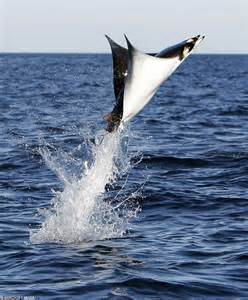
….every day at sunset, climbing the gigantic tree in my parent’s yard so I could see the river and the ocean and the sky; sneaking on my bike to the “black-road, “Riverside Drive,” in Stuart, so we kids could play in a fallen Australian Pine, pretending it was a ship and we were pirates; fishing under the bridges and then later making a pact with God that I would never do so again after the blow fish grunted so much I thought it was talking; after school, visiting the shoreline of the river, never thinking of who owned the property because it was all wild, to find hermit crabs and horseshoe crabs and any number of small and amazing creatures; seining with my classmates at the Environmental Studies Center; long summer days with my best friends in high school, learning to slalom; spending the night on the spoil islands and talking until sunrise under a gigantic shining moon; traveling from the river through the inlet into the dark blue ocean while accompanying my father fishing for sailfish, straddling front bars of the boat, to see an enormous manta-ray jump so close that I could see its eye….
Jumping manta ray public photo
Today my Indian River Lagoon adventures are less so, but still remain wondrous. This past weekend Ed and I went out in the boat at sunset with my brothers’ family and my nieces. We took silhouette photos against the sky…One day my nieces will be old too.
For the young, for the old, for the future…
“What a marvelous river it is…..”
Sunset photo over the St Lucie River 6-27-15. (Photo Ed Lippisch)
Aerial of Sewall’s Point taken by Arthur Ruhnke in the 1950s. Photo courtesy of “Sewall’s Point, the History of a Peninsular Community on Florida’s Treasure Coast,” by Sandra Henderson Thurlow. The peninsula is covered by a heavily treed hammock–although many areas were cleared for mansions, and pineapple fields earlier in the century.
Born in 1964, and growing up here in Stuart and Sewall’s Point, one thing I certainly had in my childhood was freedom. Freedom to roam. Freedom to explore. Freedom to get into trouble, or decide not to….Freedom to ride my bike. Freedom to climb trees. Freedom to read a book on an empty lot. Freedom to build forts. Freedom to catch butterflies, and to jump in the river with my friends with our clothes on if we wanted to….
Oaks of Mirimar, Sewall’s Point. (JTL 2014)
I moved to Sewall’s Point from St Lucie Estates in Stuart, in 1974. I was a 10-year-old child with my parents, and siblings. This area was still “small” not developed widely until the 1980s. Certainly, Sewall’s Point did not look as undeveloped as it did in the above photo from the 1950s—- before the “Bridges to Sea” were built, but it was certainly less developed than it is today. In fact, as a kid, I thought the entire pennisula was “mine, and we kids often played in the old, falling apart estates of an another era long past, most famously, the old “High Point Rod and Gun Club.”
The demolition of this building is what set my mother, Sandra Thurlow, on her path to write her book on Sewall’s Point (Sewall’s Point, a History of a Peninsular Community on Florida’s Treasure Coast.) In fact, it was the Sewall’s Point Commission in 1986, that “ordered the demolition,” as she states it, “of the lovely old home that stood on a bluff overlooking the St Lucie River…”
This event spurred Sandy Thurlow, “housewife,” on to become, as she calls herself, “the self-appointed history lady,” over time, writing four books on Sewall’s Point, Stuart, Jensen, and the House of Refuge on Hutchinson Island. She has educated and inspired thousands of people and won state awards. Now that I think about it, she became an “activist for history!”
Ironically, as the old adage says, “history repeats itself,” and I now find myself writing and having become a “self-appointed river activist” for the St Lucie River/Indian River Lagoon, spurred on also by its destruction.
There is always a silver-lining, isn’t there…? And when I was comparing the photographs “of old” with some below taken “today,” I noticed that one thing in Sewall’s Point still stands tall: many of its incredible trees. In fact, an arborist last year told me that Sewall’s Point is one of the only communities on Florida’s entire east coast, that still has much of its “native hammock” in tact.
Last night at a Sewall’s Point commission meeting in 2015, as a commissioner myself, I lost my composure. I think really for the very first time, ever….And although I consider myself, yes, rather intense, I pride myself on NOT losing my composure.
In discussion of pursuing policy making it tougher for residents and businesses to “hat wrack” (severely cut) or remove a tree without a permit, in one second of time, “I lost it.”
I lost it when I thought I was going to lose my fight. A fight I have been working on in the Town of Sewall’s Point for six and a half years. In the end, some miracle occurred and the commission directed the town manager to “look into it,” if nothing else, for the hardwoods or especially large-caliber oaks, many hundreds of years old…
I am embarrassed by how I acted. I even apologized. I think it is because protecting this place is in my blood and because when I was a kid I thought it was “mine….” and you know what? In way it is. It is all of ours.
Large oak cut back in 2014.Large oaks cut back at Sewall’s Point business, 2012.Oak with internal large limbs severely cut, 2013.One of two oak trees located on A1A in SP that once flowed with long limbs. In 2012, an “A1A Sewall’s Point design” was created at the direction of the commission for all AIA trees “to be allowed to canopy” over AIA after under-grounding the power lines. This large oak tree above, in a few hours, on a weekend, by one man and a chainsaw, hired by an oblivious manger of an area business was “hat-wracked,” to avoid the power lines. Other oaks and pines, east of this area, also “planned” to canopy, were cut just 3 weeks before the town paid FPL hundreds of thousands of dollars to underground the power lines. No fine was levied as the town was “seeking right of way” on the same property for AIA “improvements.” Code called for thousands of dollars in fines….the business apologized and hired an attorney while FPL feigned ignorance…Many trees are hat-wracked each year. Most offenders go before the code enforcement board which can lessen fines spelled out in the code. In any case, the practice of severe pruning continues….
Aerial, south Sewall’s Point (date unknown, maybe 1990s) Sewall’s Point is surrounded by the St Lucie on the west and the Indian River Lagoon on the east.South Sewall’s Point today-still many trees. (Photo 2015, JTL)
1949 aerial photo. Atlantic on left, Indian River Lagoon on right. Photo shows the “Peter Clive House” on Hutchison Island. Just south of this area became “Bathtub Reef Beach” through the Save Our Beaches Campaign of MC. The land furthest south became the exclusive development of Sailfish Point. (Photo Thurlow Archives/Ruhnke Collection.)
I always enjoy looking at old photographs, and fortunately my mother and father have acquired hundreds through their history work. Many of them spawn memories of what for me was a “simpler time and place” in Martin County history—as I was a child.
My mother probably took me to the “Bathtub Beach,” with family and friends, for the very first time, when I was an infant, but in my first memories of the place I was probably four or five years old.
Somewhere down from Bathtub Beach ca 1969- Lynda Nelson, Cindy Luce, and me. (Photo Thurlow Family Album)
I can remember my mother parking along the road and all of us walking– carrying all of our towels, buckets, and nets to catch tropical fish in the reef (to be returned) and my looking down and seeing bright, yellow beach-sunflowers— the sand was SO hot, you wouldn’t believe it, and there were stickers. Hundreds of stickers that stuck in your feet and you had to stop and pull them out as the sun beat down on you like a flashlight.
I remember, it became a game with me to see if I could walk in the burning sand from the road, along the path, to the beach without any shoes. I remember jumping in the cool water and swimming to the reef and sticking my homemade net into a hole to catch a little fish and a moray eel came right out and put its scary face up to my mask!
I remember the simplicity of these times, and the beauty of this place that is no longer wild like it was then, but is still equally remarkable.
This photo is labeled as “bathtub washout” no year but from the same era as above photo ca 1950. (Thurlow Archives)
The photo above shows Seminole Shores, that became “Sailfish Point” and a formalized county beach–“Bathtub Reef Beach.” Even at the time of this photograph there were “issues:” the photo is labeled “Washout.” As we all know, today, this area is still eroding away and the county must spend substantial amounts of monies in partnerships with the state of Florida to “re-nourish” this area. See chart below for all Martin County, provided for me by Martin County.
Beach Re-nourishment Costs Ten Year History, 2015.
When I really think about it, every era of history has its difficulties. It is never simple.
The aerial photos I am sharing today were taken not long after the atrocities of World War II. I was born in the social and political unrest of the 1960s…Today has its own set of problems whether it be the possibility of terrorists training in Treasure Coast airports; our eroding beaches; the “tipping point” that has occurred with releases from Lake Okeechobee and the area canals into our St Lucie River/Indian River Lagoon; our struggles with the US Sugar option land purchase; or the next population explosion that our state is counting on….
Nonetheless, it is rather amusing to me, that after all these years, some things remain the same: it is still beautiful here; I still love the fish; and somehow sometimes I still feel like I am running on the hot sands to see how long I can stand it, having to stop to pull out those irritating stickers; and every once in a while, I stick my net into a hole, and out pops a moray eel…. 🙂
Blue heron pair together in nest SLR/IRL. Photo by Paul Shidel, 2015.
In my youth, I remember a time in Rio, when my friend Vicki and I found a Great Blue Heron tangled in fishing line and hooks along the St Lucie River. Vicki, always being the leader, designated me to save the bird. I recall walking out into the shallow river and determining how I could help this gigantic and magnificent creature that stood almost as tall as myself.
The bird’s yellow/gold eyes were wild and frightened as it struggled against the line. To me, its markings resembled Indian war paint; its purple/blue coloring extraordinary. I was inspired and scared by its strength, beauty, and fight to survive.
Vicki barked directions at me, threw me a towel, and some scissors. Being careful not to hurt the bird, I cut the line from the mangrove, bringing it into my arms, gently holding its sharp beak, and then trounced back up to the shoreline. Vicki’s older sister, Beth, drove us to a wildlife veterinarian who took the line and hooks off the bird and returned it to the St Lucie River/Indian River Lagoon. This must have been sometime in the late 1970s…
The above photo, by local photographer, Paul Shidel, was recently shared, and brought back memories of this childhood experience. Birds tie into a week of blogging about destructive changes and history to the Everglades’ system.
J. James Audubon’s “Great Blue Heron” ca. 1830. (Public photo)
Believe it or not, the National Audubon Society states that only 10% of the bird life remains in the Everglades compared to its pre-development glory. We are part of the Everglades. The Northern Everglades.
*90 % of the bird life is gone….
When you see a great blue heron know you are witnessing a “survivor.”
Have you ever watched them fly? Head forward; legs back; and a steady eye on the horizon. Completely focused. We too must keep our eyes on the horizon and be completely focused.
We have a long fight forward to save the St Lucie River/Indian River Lagoon. And that we will.
* Eric Draper of Florida Audubon quoted “90% loss of birds in the Everglades” 1-22-15 during his presentation to Martin County Audubon. This statistic is widely noted.