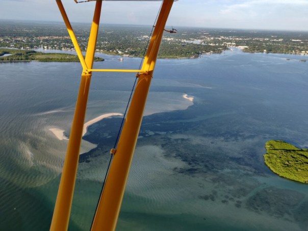
-L to R: The peninsula of Sewall’s Point lies between the SLR/IRL. The Sailfish Flats and Sandbar seagrass meadows lie between Sewall’s Point and Hutchinson Island. Witham Field, Stuart, can be seen west. The Atlantic Ocean is east. St Lucie Inlet State Park is located south on Jupiter Island. The St Lucie Inlet is cut between Hutchinson and Jupiter Islands. Today’s photos highlight the area’s returning seagrass meadows after their disappearance primarily because of years of damaging cyanobacteria laden Lake Okeechobee discharges, especially in 2013, 2016, & 2018. Photo Ed Lippisch, 8/26/22.When Ed came home from flying the RV on Friday, August 26, 2022, he said, “I think the aerials look good, you can really see the seagrasses.” I looked at him kind of funny. He never says anything like that. Looking on my phone, I could tell the photos were revealing, but it wasn’t until I viewed them full screen on my computer that I saw their true beauty. Ed’s photos reveal clear water, clear air, defined nearshore reefs, and lush seagrass/micro-algae meadows.
It is exciting to see and am I so glad Ed captured it! In the coming days and weeks tropical weather may be pushing our way. “Thank you Ed, for capturing the river before the height of hurricane season, before possibly more rains and more runoff.”
These just might be the most beautiful recent photos ever taken of the St Lucie River/Indian River Lagoon. Over the past couple of years, we’ve had some good ones of blue water alone, but blue waters cradling seagrass beds, the life of the sea itself, this is “true beauty.”
These improvements have only been possible due to recent ACOE policy decisions – no major Lake O discharges for over three and one half years, and Mother Nature, who so far, has not brought any of her discontent our way.
At this time, it is in order to thank former City of Stuart Mayor, Merritt Matheson, who went to great lengths over the past four years to hold accountable and build relationships with the Army Corps of Engineers. Mayor Matheson led numerous boat tours and meetings inviting, colonels, commanders, and staff. His St Lucie River tours led by an elected, passionate, educated, local helped the ACOE understand the fragility of our region and the intense ecological and health impacts caused by discharges from Lake Okeechobee. Mayor Matheson your efforts made a tremendous difference for the health of the St Lucie River. Thank you.
This past weekend, March 19, 2022, Ed and I had a chance to spend the night in the area of Boy Scout Island, “Adrfit.” We met up with our friends, the Radabaughs, of “Cinnamon Girl,” and ate lasagna and drank wine under a full moon -toasting the Indian River Lagoon’s beauty and importance. It was magical! We brought along our Belgium Shepard, Luna and our cat, Okee. The entire family was present. These are the days to be thankful for. But something was missing…
On Saturday, we tooled around on our blow-up canoe. Ed accidentally hit me over the head with a paddle and I still have the bump to prove it! I screamed out loud! We just about capsized in the strong winds, raging current, and choppy waves, but we held fast.
It was an incredibly stunning night and day. But there was one thing missing in the clear waters, our seagrass meadows. It may lush-out as we approach summer, but it certainly seems lean. Nonetheless, we saw manatees, giant leopard rays, starfish, schools of mullet, pelicans, and many kinds of wading birds. I just pray that the seagrass returns, because without, clear water or not, we are a desert or becoming one.
There have been no major discharges from Lake Okeechobee in three years, this is certainly giving the southern lagoon a fair chance for recovery. But again, clear water must have seagrasses to be of ecological value.
-Sunrise over St Lucie River/Indian River Lagoon-Moonset over Sewall’s Point-Cinnamon Girl-Cloud formations-Morning visitors! -Okee watches Dutch and Holly -Ed and Luna go for a spin-A journey through the mangrove forests-Mullet
-Red mangoes and black mangroves roots. Black mangroves can get very large and have straw-like roots; red mangroves are known as the “walking tree” as they stride-out in arches -Ibis fly-A cathedral of red mangroves!
-Don’t fall in!-Mary, Lisa, Dutch and Colton taking a look at the water and s”seagrasses”-View of Boy Scout Island -so blue!-Area around Boy Scout Island where once seagrass was plentiful. Now small blades, rhizomes, and macroalgae.
-Looking west, brown pelicans float after diving for fish. At least they can see. No coffee colored Lake O or canal water today! This area near the St Lucie Inlet gets lots of flushing, most of the St Luice does not. -Colton found a nine-armed starfish, eastern area -Luna watches, her black coat juxtaposed to turquoise water. Luna does not run in the shallow waters. She would damage the roots remaining seagrass. She is happy anyway!
THIS 1977 AERIAL BY CHRIS PERRY SHOWS HOW LUSH THE SEAGRASS IN THIS AREA OF THE ST LUCIE INLET ONCE WAS. TODAY THIS AREA IS BARREN. I was 13 years old at the time this photo was taken; I am 58 today…
In spite of Florida’s significant development, the health of estuarine seagrass is something we expect and treasure. Being the home of baby fish and wildlife, estuaries are often called the “cradle of the ocean.”
According the the USDA, “estuaries are among the most productive natural systems on earth.” Their value? Perhaps priceless. And we are losing money fast.
Today I wanted to share information presented at a Rivers Coalition meeting now posted for the St Lucie/Indian River Lagoon estuary; I will touch on four other sister estuaries as well: Caloosahathcee; Lake Worth Lagoon; Biscayne Bay; and Florida Bay. Being familiar with each, can help us advocate for the value of the greater whole.
I. St Lucie/Indian River Lagoon
Last week, my brother Todd Thurlow, shared satellite and GIS images that show a story of seagrass loss in the St Lucie River/Indian River Lagoon estuary in an area known to locals as Sailfish Flats. I have taken screen shot images of Todd’s website below. The first image was taken in 2007 and the second on 2-24-2021. In spite of yearly variations due to season, temperature, and other natural changes, I think it is clear that seagrass has declined. The real killer is that the St Lucie River/Indian River Lagoon had once attained the greatest species diversity of any estuary in North America, (Lodge, The Everglades Handbook, 4th Edition, page 175).
Right now, it appears that seagrasses have disappeared in the Sailfish Flats region. The reason? Certainly there are many including the damaging discharges from Lake Okeechobee, and canals C-44, C-23 and C-24. ~Hurricanes? Climate Change? Sea level rise? Fertilizers from local runoff? Destruction of native trees and vegetation? Earlier dredge and Fill? Septic Tanks? Dredging? Beach Renourishment? But some of these things have gone on for decades, so why now such a difference? Please share your ideas and experiences.
To see all images throughout many years visit Todd’s website eyeonlakeo.
-Seagrass loss a visual survey, Sailfish Flats, SLR/IRL, 2007 compared to 2021
II. Caloosahatchee
I am no expert in the Caloosahatchee, but it is commonly known that if it gets too saline in the upper estuary, the underwater grasses there can die. I am sharing the most recent Sanibel Captive Conservation Foundation “Caloosahatchee Conditions Report” as it shows the organization recommending 2000 cfs from the ACOE (Lake Okeechobee) but will be recommending less or none in the future.
III. Lake Worth Lagoon
Lake Worth Lagoon, once a huge freshwater lake, is now open to the sea. LWL has many issues, but sediment covering seagrasses -especially from the C-51 canal- is a big one. You can learn more at the Palm Beach County’s Environmental Resource Management website.
IV. Biscayne Bay
The South Florida Water Management had an outstanding workshop on Biscayne Bay last December. Seagrass loss was a big topic and they had just had a fish kill. You can learn more here.
V. Florida Bay
Florida Bay has endured significant seagrass loss, especially, most recently in 2015. This year due to 2020 rains, the Bay is having a very good year as recently reported by the SFMWD. (See page 24). Audubon’s Everglades Science Center is a good website to learn about issues of seagrass loss and others facing Florida Bay.
“Seagrasses? What seagrasses?” It must be “Seagrasses! What Seagrasses!”
The Crossroads off Sewall’s Point in the confluence of the St Lucie River and Indian River Lagoon. In 2019, seagrasses can be seen returning to an area that was post-2013, 2016, and 2018 a desert of sand. 8-3-19 photos by Scott Kuhns.
On August 3rd, I posted the above aerial noting the return of visible recovering seagrasses since the ACOE stopped discharging from Lake Okeechobee.
One of my readers wrote: “Most is not true seagrass, some algae’s, discolored sand. A little shoal grass here and there. It’s gonna take a few years of no discharges.”
And this is true. Seagrass is growing back, but right alongside, or even on the algae itself, is something else. A type of dark green, slimy-algae covering the grasses. I don’t remember it like this before…
We are living in a time of over-nitrification. Too much Phosphorus and Nitrogen drains off the land into the estuary feeding algae of all kinds as they compete for dominance.
And we decide who wins:
~A great video shared by my brother Todd covering the story of all types of algae and cyanobacteria.
8-3-19 Scott Kuhns what do you see?
8-3-19 Scott Kuhns looks back towards Stuart from St Lucie Inlet area. Area to right was once famous for its rich seagrass beds.
I have seen the microalgae growing back on our seagrasses in the SLR/IRL, and it has been here for years; it is just getting more dominant. I have not photographed as doing so requires a protected camera. Thus I am sharing these photos that in some ways resemble our beds.
My husband, Ed, took these photos of the Indian River Lagoon at the St Lucie Inlet on 2-28-18, just a few days ago. They are certainly beautiful enough to sell real estate…The turquoise water is so pretty one could easily overlook the sand desert below the surface waters.
Enjoy the blue water, but know that especially since 2013, our seagrass beds have been decimated by black sediment filled waters and toxic discharges from Lake Okeechobee. Seagrasses are the nursery for all sea life, especially the baby fish. These beds need time to reestablish if they ever will.
True beauty has something to offer, not just “surface water.” Keep your eye on the lake and fight against any coming releases this summer so we can get life back in our dear dead river.
IRL in Jensen, ca. 1948 Seymour Gideon property, courtesy Sandra Henderson Thurlow Archives. (Note clear water and abundant seagrasses.)
This photo is on page 23 of my mother’s book Historic Jensen and Eden on Florida’s Indian River. The insert reads:
“This photograph of the Seymour Gideon property was made after 1948 when Arthur Ruhnke started taking photographs locally, and before the August 26th 1949 hurricane that destroyed the fish houses. A trail leads to the ridge called “Mt. Washington” (Killer Hill, Skyline Drive today) by the pioneers. The watery expanses of the Jensen Savannas are in the distance. Notice the clear water and the abundance of river grass.” (Thurlow/Ruhnke Collection)
It is a beautiful photograph….isn’t it? Certainly after the Hurricane of ’49 hit the seagrasses of Jensen in the Indian River Lagoon were impacted too!
~Wind gusts reached 160 mph (260 km/h) at Stuart.
~Stuart (Jensen) experienced the most severe damage from the storm in south Florida; hundreds of homes, apartment buildings, stores, and warehouse buildings lost roofs and windows. Interior furnishings were blown through broken glass into the streets.
When hurricanes Frances and Jeanne hit within three weeks apart in 2004, entering both times at my hometown of Sewall’s Point, there was reported loss not only of property, but also of seagrasses in the Indian River Lagoon. Seagrass is very slow to recover…
Photo by Lauren Hall, SJRWMD, showing healthy seagrasses in the IRL. (From Save the Manatee Website)
As some locations of the grasses were experiencing recovery, they died back again due to the extreme discharges and toxic algae blooms in 2013 and 2016 ~linked to Lake Okeechobee, and canals C-44, as well as C-23, C-24 and C-25.
Canal and basin map SLR/IRL. (Public)
The South Florida Water Management District reports periodically on not overall numbers but rather “patch dynamics” at certain locations of the lagoon. (For Martin County: Boy Scout Island and Willoughby Creek.) I feel this is limited. The best way to see seagrass bed coverage is from the air. I am hoping in the future there will be money in the budget or the District could coordinate with local pilot for aerial seagrass surveys. Another way to approach this is though Google Earth mapping/aerials, and my brother Todd Thurlow and Mark Perry of Florida Oceanographic are working on this now.
Hurricanes, discharges, fertilizer from our yards…Seagrasses are as important as property as they are the nurseries of the oceans and keep the lagoon “living.” Look at the aerials below to see the losses, so that we may be inspired to work for and better document a recovery.
Jacqui
Frances, September 4, and 5th 2004. NOAA image.
Aerial of seagrasses in 1977 in and between Sailfish and Sewall’s Point, courtesy FOS, Chris Perry.
Murky greenish water could be seen in the area of the Sandbar, between Sailfish and Sewall’s Point, and some remaining sickly looking seagrass beds were visible, 3-15. (Photo JTL.)
5-25-16 remaining seagrasses with algae on top SLR/IRL between Sewall’s and Sailfish Point, JTL
5-7-17 blue water but no visible seagrasses between Sailfish and Sewall’s Point, JTL SLR/IRL
Waters off of Sewall’s Point in August 2013 during high levels of discharges from Lake Okeechobee. Seagrass beds between Sewall’s and Sailfish Point used to be the lushest in the southern lagoon…(photo, JTL)
Seagrass….it has had a rough few years in the Indian River Lagoon-south,central, and north. Seagrass is a flowering plant, and just like plants that grow on land, it “comes and grows” with the seasons. We are just going now into spring…maybe it hasn’t flowered yet? Maybe it really grows in summer? Anyway…
My husband, Ed, brought home these photos yesterday of the area between Sewall’s Point and Sailfish Point. The area looks pretty naked to me. Ed will fly over again and we will watch whether the seagrass comes back or not. At least these are good baseline photos for 2016.
We all know the seagrasses have been terribly compromised throughout the years of due to agriculture and developments’ rampage in Florida, and Mother Nature’s too. For instance, 2004 and 2005’s hurricanes, 1998 and this year’s El Nino…Tough times were especially visible in 2013 with the toxic Lake O “Lost Summer,” and again this year in 2016—-with the constant releases from Lake Okeechobee since January. But even with these tough conditions the seagrass usually comes back, although weaker than before.
At the end of the blog I linked a post from August 2015, where you can see the seagrasses here in 2015 that looked dark and full of algae but were visible.
Just in case you don’t know, the location between Sewall’s Point and Sailfish Point is considered the cradle of the St Lucie River/Indian River Lagoon. For years it has been labeled the “heart of the most biodiverse estuary in North America,” with more fish species that any other, over 800 (Grant Gilmore, formerly of Harbor Branch).
What a crime to allow this fishery to go into to such demise. A nursery that affects all of Florida’s east coast. An engine for our economy and quality of life for all species.
To conclude, the photos Ed took below are in two groups: taking off from Witham Airport in Stuart (1-11) and then from Jupiter Island over the waters of Sewall’s and Sailfish Point (12-26). Parts of these waters are known as the Sailfish Flats. You will notice the waters of Lake O slowly exiting the St Lucie Inlet.
1. DCIM103GOPRO
2. DCIM103GOPRO
3. DCIM103GOPRO
4. DCIM103GOPRO
5. DCIM103GOPRO
6. DCIM103GOPRO
7. DCIM103GOPRO
8. DCIM103GOPRO
9. DCIM103GOPRO
10. DCIM103GOPRO
11. DCIM103GOPRO
12
13.
14.
15.
16.
17.
18.
19.
20.
21.
22.
23.
24.
25.
26.
Sewall’s Point is the peninsula between the SLR/IRL and Sailfish Point is the ball like formation at the south end of Hutchinson Island (R) Atlantic on far R. Stuart is far left with Witham Field clearly in center. (Google Maps 2013) This is the southern IRL.
Aerial of SLR/IRL. Confluence of St Lucie River/Indian River Lagoon near St Lucie Inlet with low tide exposed sea grasses looking bleak. (Photo Ed Lippisch; plane piloted by Scott Kuhns 8-20-15.)
Most recent chart showing discharges into the SLR from area canals C-23, C-24, C-44 Ten Mile Creek, and “Tidal Basin” –from rainfall. No Lake O. (From ACOE Periodic Scientist Call 8-18-15. Image courtesy of the SFWMD.)
Basin chart, SFWMD.
As we all know, until last week, it has been raining a lot! Almost daily it seems the grey clouds gather and beat their chests threateningly; most often making good on their promise. This past week was the first time in a long time, my husband, Ed, could get up in the Cub and photograph the river. I will share these photos today.
Following are two sets of photos; the first Ed took on Thursday, August 20, 2015, and the second set were taken by Ed and friend Scott Kuhns, Sunday, August 23, 2015.
The point of the blog is to share the photos, and celebrate our 2015 “clearer waters” near the Indian River Lagoon’s southern inlets, but also to feature the weaker-looking “rain-event, fresh-water plumes.” You may recall the wretched, horrific looking plumes of the Lost Summer of 2013 during the discharges from Lake Okeechobee and area canals? Here is a photo to remind you taken in September 2013:
St Lucie Inlet September 2013 looking towards Sailfish Point.(JTL)
2015’s summer rain induced plumes do not include Lake Okeechobee releases, or the other conditions of 2013; this summer’s plumes are not as severe looking as 2013’s as you will see. Thus we have “clear water,” even when there is a lot of rain.
Last, I ask you to note the photos of the seagrasses around the Sailfish Flats area between Sewall’s Point and Sailfish Point. I am no scientist, but I think they look awful. Recently, I was told having some algae on the seagrasses is good in that when they are exposed during low tide they are protected from the burning sun. That is nice to know. Nevertheless, they look weird. Like there is too much algae; they do not look healthy. They appear grey and sickly. It is obvious they are not recovered yet from 2013 and before.
Seagrass beds of the St Lucie River/Indian River Lagoon near St Lucie Inlet 8-20-15.
I do not have a “before aerial.” but this photo from the St Johns River Water Management District show up close what healthy seagrasses look like and I do not think ours look anything like this right now.
Photo by Lauren Hall, SJRWMD, “up close” showing what healthy seagrasses should look like in the IRL. (From Save the Manatee Website)
So here are the photos, enjoy the clearer water thus far this summer, and please stay on the Water Districts and politicians noting that clear water doesn’t mean healthy seagrasses. We have a long way to go!
Sailfish Flats outskirts off Sewall’s Point near St Lucie Inlet. Beautiful blue waters but odd-looking sea grass beds. 8-20-15. (Ed Lippisch)
St Lucie Inlet with weak plume exiting northerly through jetty with most going south. 8-20-15. (Ed Lippisch)
Sewall’s Point, 8-23-15. (Ed Lippisch)
Sailfish Flat between Sailfish Point and Sewall’s Point. Here aside Hutchison Island looking southwest. 8-23-15. (Ed Lippisch)
St Lucie Inlet 8-20-15. (Ed Lippisch)
Weak rain plume exiting SL Inlet with near shore reefs in clear view through clear ocean water. 8-24-15. (Ed Lippisch)
View of rain plume hugging shoreline as it leaves St Lucie Inlet along Jupiter Island. 8-24-15. (Ed Lippisch)
THESE LAST PHOTOS ARE OF FT PIERCE INLET. FT PIERCE INLET GETS WATER FROM C-25 WHICH DOES NOT DISCHARGE INTO THE ST LUCIE BUT DIRECTLY INTO THE IRL JUST OUTSIDE OF THE FT PIERCE INLET AT TAYLOR CREEK. C-25 IS NOT SHOWN ON THE CHART AT THE BEGINNING OF THIS POST FOR THE ST LUCIE RIVER. C-25 CAN ALSO RELEASE WATER FROM THE C-23 AND C-24 CANALS IF THE SFWMD DIRECTS SUCH. SEE CANAL MAP BELOW.
Canal and basin map SLR/IRL. (SFWMD)
Ft Pierce Inlet takes water from C-25. This water exits directly into the IRL at Taylor Creek and Marina. 8-23-15. (Ed Lippisch)
Ft Pierce Inlet 8-23-15. (EL)
Ft Pierce Inlet. 8-23-15. (EL)
Thank you to my husband Ed Lippisch, friend Scott Kuhns for these photos. Also thank you the ACOE and SFWMD for sharing their chart information.
Atlantic shoreline just south of St Lucie Inlet along Jupiter Island contrasting 6-20-15 clear waters to of 9-8-13’s dark waters. Dark waters reflect discharges from Lake Okeechobee and area canals C-23; C-24, and C-44. Blue waters reflect “no rain” and no dumping for one month from the ACOE and SFWMD. (Photos Jacqui Thurlow-Lippisch and Ed Lippisch)
Monday’s blog contrasting the beautiful, blue-waters of the St Lucie River/Indian River Lagoon this summer in 2015, to the silty, dark-brown waters of the “Lost Summer” of 2013 was well received, so today will post some more photos of this “contrast.”
My husband, Ed, encouraged me to do more framed contrast photos; however, time does not permit so there is just one “framed” photo above and the rest will be separate photos. I will try to do more framed ones in the future.
Also, although Ed and I have taken thousands of photographs, they do not always “match up” in location so the visual perspectives are not “exact.” My goal while in the plane is simply to hold on to the camera, hoping it does not fall into the river. It is always very windy in the open Cub. Getting a good photo is just secondary! I mostly just use my iPhone.
Well, a picture speaks a thousand words….” so I’m not going to “say” anything else…All photos are contrasting June 20th 2015 with either August 11th or September 8th of 2013.
Thank God we having a beautiful summer!
Bo and Baron, our dogs, sitting by the Cub Legend, the plane used for most of the photographs. (JTL) In 2013 it was christened the “River Warrior” plane. 🙂
St Lucie Inlet looking west towards Stuart, Sailfish Point barely visible on far right of photo. Jupiter Narrows and “Hole in the Wall “on right. June 2015.
St Lucie Inlet September 2013 looking north east towards Sailfish Point. Plume heading towards St Lucie Inlet.
Looking northerly towards Sailfish Point and St Lucie Inlet. Sailfish Flats between Sewall’s Point and Sailfish Point are visible here. Sewall’s Point is to the right or west of this photograph. (June 2015.)
Looking north toward Sewall’s Point on east/left. The Sailfish Flats are to the right/east as is Sailfish Point. (September 2013.)
Shoreline of Jupiter Island June 2015.
Jupiter Island ‘s Atlantic shoreline Sept 2013.
Sailfish Flats between Sailfish and Sewall’s Point 2015.Seagrasses remain decimated and covered in algae.They come back very slowly.
Wideview of Sailfish Flats area between Sewall’s (L) and Sailfish (R). Points. (Aug 2013)
St Lucie River, west side of Sewall’s Point 2015. Point of Hell’s Gate visible on to east/right. June 2015.
St Lucie River, west side of Sewall’s Point looking towards Evan’s Crary Bride. Hell’s Gate is on east/right but not visible in this photograph. August 2013.
The remainder below do not match at all, but provide contrast:
St Lucie Inlet June 2015.
St Lucie Inlet June 2015.
Hutchinson Island looking south to St Lucie Inlet, June 2015.
Blurry but St Lucie Inlet in sight with near shore reefs south of of inlet very visible. (June 2015) These reefs have been terribly damaged by the years of releases from Lake O and the area canals (silt and poor water quality) even though they are “protected” by the State and Federal Government.
Crossroads SLR/IRL to St Lucie Inlet (R) with Sewall’s Point on left. Looking at flats area full of seagrass that bas been damaged again and again by releases. Once surely considered the most “bio diverse estuary” in the North America–1970s Grant Gilmore. Photo August 2013, it is surely not today.
Same as above but closer to Sailfish Point nearer St Lucie Inlet Sept 2013.
Crossroads Sept 2013.
Looking toward Palm City Bridge 2013. St Lucie River.
IRL side east of Sewall’s Point September 2013.
Inlet area looking at Sailfish Point and St Lucie Inlet 2013.
South Sewall’s Point’s waters at Crossroads of SLR/IRL near inlet, 2013.
The Crossroads of the SLR/IRL as seen during incoming tide with discharges from Lake O and area canals. (Photo by Ed Lippisch, 3-30-15, 5:PM.)
With all the fanfare of President Obama’s visit and the confrontation that seems likely at the April 2nd SFWMD, Water Resources Advisory Board meeting between “Stop the Land Grab” (http://goo.gl/2YVLXT) and the River Warriors, it is important to keep our “eye on the ball.” THE RIVER.
Since January 16th of 2015, the ACOE and SFWMD have been overseeing the releases from Lake Okeechobee into the St Lucie River/Indian River Lagoon. (The ACOE technically oversees this; however, collaboration includes the science of both agencies.)
January is very early to start releases, but the lake “is high” for this time of year. Due to releases and evaporation, it is slowly going down and now at 14.04 feet. The goal 13.5 (?) or so, but they won’t say that because one must “be sensitive to water supply” for agriculture and other users…(http://w3.saj.usace.army.mil/h2o/currentLL.shtml)
Today, I will share photos by my husband, Ed Lippisch, that were taken yesterday around 5pm during the onset of an incoming tide. Ed was piloted by friend Scott Kuhns. Thank you Scott and Ed! 🙂
As mentioned in an earlier blog, the ACOE is PULSE RELEASING and lowering releases into the SLR through S-80 right now in an attempt to help Martin County evaluate bacteria testing that cannot be done during heavy discharges. It is interesting to note that pulse releases mimic nature so that the estuary is not continually pounded, and can recover a bit. Just like during a rain event, the water flow is intense, salinity drops, and then salinity increases when the water lets up. You can see the schedule below.
ACOE pulse release schedule May 26, 2015. S-80 is the structure from the C-44 to the SLR letting in water from S-308 at Lake O.
One of the most interesting photos is of Sailfish Point’s marina where the runoff into the SLR/IRL is very apparent. There is always runoff from land into the rivers, yet we must remember the rain takes everything on the land with it: fertilizer, pesticides, herbicides, loose sediment….Martin County’s strong fertilizer ordinance rules don’t begin until June 1st, so it is likely that this runoff is full of pollution that like releases from Lake Okeechobee or area canals is not good for seagrasses.
For me the aerials of the seagrasses are most depressing. The once healthy beds look horrible. One can see they have algae all over them . Maybe I’m hyperbolizing, but the seagrasses do not look good to me. Having grown up here and swam in these area waters as a kid when they were lush and full of life—-the present condition is not acceptable.
Anyway, let’s keep our eye on river and we move through all these politics, and here is a look from above at YOUR RIVER!
1. SLR/IRL Crossroads with Willoughby Creek area in foreground looking towards Jupiter Narrows and the SL Inlet.
2 Confluence of SLR/IRL off west side of Sewall’s Point.
The Crossroads of the SLR/IRL with discharges from Lake O and Area canals making it dark brown. (Photo by Ed Lippisch, 3-30-15, 5:PM.)
4. Sewall’s Point looking towards Hutchinson Island, IRL.
5. Unhealthy looking seagrass beds off of Sewall’s Point and Sailfish Point.
6. Sad looking seagrass beds seem to have algae on them thus so dark and flat looking….
7. The Sandbar.
8. Sailfish Point and Simpson Island.
9.Sailfish Flats.
10. Martina at Sailfish Point with runoff from land due to rains.
11. Another shot of Sailfish Point Marina.
12. Long shot of Sailfish Point marina with runoff clearly seen and Ed’s thumb!
13. SL Inlet with plume on left as incoming tide enters.
14. Hole in the Wall with plume and incoming tide.
15. SL Inlet.
16. Sailfish Point and inlet; north side is clean incoming tide-water. Plume goes south….
Basins of SLR/IRL SFWMD
ACOE/SFWMD discharge most recent discharge chart. Most is from Lake O in this chart as seen in blue.
ACOE S-308 structure showing water released into SLR/IRL from Lake O.
ACOE excerpt —Info that goes with the above pulse release schedule; it is from 3-26-14. Another will call will occur today and updates will be considered.
UNCLASSIFIED ACOE
Caveats: NONE
“Based on the current lake levels, tributary hydrologic conditions, and multi-seasonal forecast, 2008 Lake Okeechobee Regulation Schedule (2008 LORS) Part D guidance is up to 3000 cfs at Franklin Lock and Dam (S-79) and up to 1170 cfs at St. Lucie Lock and Dam (S-80). We have considered stakeholders input and recommendation from the South Florida Water Management District.
The U.S. Army Corps of Engineers Jacksonville District will be continuing discharges at S-79 at the same level as last week. However, the target discharges are reduced at S-80. The target flows over a 7-day period will be an average of 2500 cfs at S-79 and 500 cfs at S-80 cfs. These discharges will be made in a pulse-like manner (see attached).
These releases will start Friday, 27 March 2015 at 0700 hrs and end on Friday, 03 April 2015 at 0700 hrs.”
Confluence of St Lucie River/Indian River Lagoon between Sewall’s Point and Sailfish Point, Hutchinson Island, “The Crossroads,” 3-8-15 showing releases from Lake Okeechobee and area canals. (Photo Ed Lippisch)
Usually, my husband, Ed, does not like it when I ask him to “do things”…like take out the trash or blow leaves off the driveway. But he always likes it if I ask him to go up in the plane. He did so yesterday, and was able to visually document the polluted discharges pouring into our St Lucie River/Indian River Lagoon.
Yes, once again.
The Army Corp of Engineers (ACOE), and the South Florida Water Management District (SFWMD) agreed to have the Army Corp start releases this year on January 16, 2015 at 200 cubic feet per second (cfs) through S-308 into the C-44 canal which is attached to the South Fork of the St Lucie River, and then in turn is connected to the Indian River Lagoon “my town,” Sewall’s Point.
Exhausting isn’t it?
The ACOE is now discharging at a rate of “950 cfs.” This rate goes up and down. It is going up because Lake Okeechobee is not going down…
This SFWMD basin map also shows S-308 at Lake O, the C-44 canal, S-80 at St Lucie Locks and Dam, SLR/IRL.
Today I will share Ed’s photos and show how to “see” how much the ACOE is releasing at S-308. (Structure 308) which is located at Port Mayaca, in Indiantown, Martin County.
Ofcouse, there are discharges from area canals C-44, C-23, C-24 and C-25 as well, but today for simplicity’s sake, I will focus on the lake discharges today, which in my opinion, are the worst of all anyway—because they are not at all “ours.”
So—–
You can search “Jacksonville, ACOE” or just go to this link: (http://w3.saj.usace.army.mil/h2o/reports.htm). You can then very quickly check two things: Lake Okeechobee’s level and how much the ACOE is dumping at S-308 from the lake.
To do so, after accessing the site, go to “Current Lake Okeechobee Water Level” at the top left: Always one day behind or so, the latest date reported is 3-7-15– Lake O is at 14.71 feet. Then go back to the main page to the last link: “Port Mayaca Lock, S-308 Spillway.” View by date; the last date shows 873 cubic feet per second (cfs) being discharged.
Front page of ACOE Lake O website, 2015.
3-9-15 Lake O level 14.71 feet. NVGD.
S-308 report shows 873 cfs on 3-7-15 going into C-44 or SLR.
Here are some more photos Ed took yesterday, 3-8-15, of the SLR/IRL.
West side of Sewall’s Point, 3-8-15 showing St Lucie River. (Ed Lippisch)
East side of Sewall’s Point, 3-8-25 showing Indian River Lagoon. (Ed Lippisch)
Southern tip of of Sewall’s Point showing SLR in foreground and IRL in background. 3-8-15. (Ed Lippisch)
Known as the “Crossroads” this area off of S. Sewall’s Point is the confluence of the SLR/IRL. The St Lucie Inlet is just off of the tip of S.Hutchinson Island and is known as Sailfish Point and is blocked in the far upper right of this photo. 3-8-15. (Photo Ed Lippisch)
St Lucie River/Indian River Lagoon near Sewall’s Point and Sailfish Point, Hutchinson Island. “Crossroads.” (Photo Ed Lippisch)
SL Inlet in distance, 3-8-15. (EL)
3-8-15. IRL. East of Sewall’s Point. (EL)
When Ed got home, he said I was lucky I did not go up with him as it was windy which means bumpy…He also said the plume looked different from what we have seen before. It looked “chalky” as is seen in these two photographs below and extended about two miles off shore and further south of the St Lucie Inlet.
I am no scientist, but I would imagine this is silt/suspended solids in the water as everything is “stirred up” from the wind. Suspended solids falling on and smothering our reefs….
Plume off St Lucie Inlet, 3-8-15. (EL)
Plume another view 3-8-15. (EL)
Map showing reefs in Marin and Palm Beach counties. The reef in MC is directly impacted by the discharges from Lake O. (map courtesy of state.)
In closing, I must thank my husband for the photos, and I must point something out.
This area around Sewall’s Point and Sailfish Point, this “confluence” of the St Lucie River/Indian River Lagoon, in the not too distant past, has been documented as the most bio-diverse estuary in North America (Dr. R. Grant Gilmore, senior scientist with Estuarine, Coastal and Ocean Science, Inc., (ECOS)(http://www.floridaoceanscouncil.org/members/bios/gilmore.htm).)
The map below allows us to see where these precious seagrass beds are/were located. The map above shows where our “protected” near shore reefs are located just outside the St Lucie Inlet where the discharges go out to sea. These reefs are the northern most “tropical reefs” on the east coast of Florida…
SFWMD seagrass map, 2015.
I think it is a truly a sin that the ACOE and SFWMD year after year discharge onto these productive sea grass beds and near shore reef habitats that are the breeding grounds for thousands of fish and sea creatures. Its loss is felt all the way up the food chain, including “us.”
Where is the Department of Environmental Protection? Where is the Florida Wildlife Commission? Where is NOAA?
Not to mention, last year a designation of “Critical Wildlife Area,” —the first in 20 years for Florida—for 30 plus species of nesting and resting protected birds, was established on “Bird Island,” located just 400 feet off south Sewall’s Point….”Now” is right before nesting season’s height. Where will the birds find food when the seagrass beds are covered in silt and the water is so dark they can’t really see? Chances are these releases will continue.
Don’t our state agencies have a duty to protect? Don’t they have a voice or has it been muffled? Not a word? Not a peep. Where is our governor? Isn’t this money? Isn’t the productivity our of waterways linked to our businesses? Our real estate values? Where is our local delegation? Have we all become numb to this destruction? Beaten down and manipulated so long we that have no reaction?
It breaks my heart.
Our state and federal government entities responsible for “protection” especially should hang their heads in shame.
If nothing else “speak out” about how bad it is. Recognize the loss. Address the “constraints,” killing this ecosystem and local economy. Take leadership!
Be true to our heritage. We are the United States of America. Be brave. Speak out!
 When Ed came home from flying the RV on Friday, August 26, 2022, he said, “I think the aerials look good, you can really see the seagrasses.” I looked at him kind of funny. He never says anything like that. Looking on my phone, I could tell the photos were revealing, but it wasn’t until I viewed them full screen on my computer that I saw their true beauty. Ed’s photos reveal clear water, clear air, defined nearshore reefs, and lush seagrass/micro-algae meadows.


