A view from Airglades Airport, the business center of proposed US Sugar’s “SugarHill” development, looking southerly into a horizon of agricultural lands. (All photo by Ed Lippisch, 9-27-14)
(* I have just realized the photo above is the old Clewiston Airport not Airglades. Here is one of Airglades from http://www.airnav.com/airport/2IS. JTL 9:30 AM.)
Airglades Airport, photo AirNAv.
The flight last weekend: Stuart to Clewiston…
I could not be a passenger, it was too windy and I knew I would be sick hanging my head over the edge of the Cub. It has happened before.
In the yellow Piper Cub, the fight to Clewiston from the St Lucie River/Indian River Lagoon, in Stuart, is about 45 minutes one way, a long time if the air becomes a rough ocean.
Approaching Clewiston from the east.
So my husband, Ed flew alone and sent me a few photos along the way. He will do anything to get up in that airplane. For him it is fun even if it is windy.
So let’s take a closer look where Ed flew, to that area we all keep taking about in Hendry County and proposed first by US Sugar Corporation: SugarHill.
As one can see from the map below, Airglades Airport is west of Clewiston close to where Highway 27 shoots north. The SugarHill sector plan land use change encompasses a tremendous amount of land, 44,000 acres, these lands are located where the state has an option to buy for Everglades restoration. If some of those lands get zoned for residential and commercial development it could complicate trying to send water south through trading these lands or using them for restoration in the future. That’s why we want to take a look.
Location of Airglades Airport, Google Maps, 2014.Sugar Hill proposal, 2014.A view from Airglades Airport, (same photo as above) shows runway on right, development on left, and miles and miles of surrounding agricultural lands.Agricultural lands.Agricultural lands.More agricultural lands and canal.Very north-west over what was once Lake Hipochee, headwaters of the Caloosahatechee.Flying back to Stuart looking back to Clewiston.
So basically the SugarHill sector lands are west of Clewiston, there is an airport, some development and miles and miles of agriculture. What is shall become only time will tell. I hope now that you’ve had a look, it will be easier for you to make a decision to protect these lands for the Everglades, St Lucie River and Indian River Lagoon.
Newly elected Congressman Partick Murphy holding recycled FDOT signs painted by the River Kidz. The flag sign was taken to Washington DC and displayed in the front office, 2012.
I support politicians that work in the interests of the St Lucie River/Indian River Lagoon. The river doesn’t belong to a political party; it belongs to all of us.
To me, people are more important than their political affiliations.
From the beginning Patrick Murphy displayed that he wanted to work with everyone. After winning Florida US House District 18, he came to Martin County and met with leaders of all municipalities and the county, together. He introduced himself and ask us what issues were most important to us. The health of the St Lucie River/Indian River Lagoon was the top agreed choice and Patrick got to work.
Looking back, little things say a lot.
I recall I was impressed that he wasn’t afraid to get his “hands dirty.” He immediately participated in an oyster restoration event in Ft Pierce with St Lucie County Commissioner, Chris Dzadovsky. Dzadovsky ended up suffering from a skin infection due to an oyster cut during the oyster deployment….Congressman Murphy quickly caught on to the seriousness and the extent of the Martin, St Lucie river problem and how much the river’s improvement meant to the local people.
Another plus for me was that he quickly befriended the River Kidz and took their call for “getting involved, speaking out, and raising awareness”seriously. Some members even went to Washington DC to participate in his IRL meeting with congressional leaders. Now that’s a first!
Patrick’s list of accomplishments is broad including pushing hard for monies for the C-44 Storm Water Treatment and Reservoir for C-44 basin runoff; and CEPP, the Central Everglades Planning Project that if ever approved will divert about 12% of Lake Okeechobee’s water south, and monies for the National Estuary Program’s revamping. The list goes on, please see image below.
Flyer of Murphy’s IRL “Action and Advocacy.”(Click to enlarge.)Side two of flyer.Congressman Murphy in Washington DC with River Warriors, River Kidz and commissioners, and others, for session on IRL. In spite of a government shutdown, many congressional leaders met with the group. (Photo Nicole Mader, 2013.)
I know over time there is a lot more to do. But the young congressman is off to a great start and most important, we have developed a relationship with him. We must keep this relationships going. For in the end, no political party will save the river; it is only people and their relationships that can do that.
Patrick at fundraiser held in the Town of Sewall’s Point by Karen Cahan. Sewall’s Point is known as a “republican enclave,” 2013.Speaking on behalf of Congressman Murphy at his campaign headquarter in Stuart, 2014.
_______________________________________
Campaign commercials I have done in support of Congressman Patrick Murphy, Democrat and Senator Joe Negron, Republican, 2014.
Sunrise Roosevelt Bridge draw bridge, photo by John Whiticar, 2014.
All Aboard Florida and NOT All Aboard Florida have Henry Flagler’s East Coast Railway on the front page of every paper along Florida’s Treasure Coast.
History and urban legend have some railroad stories of their own I’d like to share….
According to the book, The History of Martin County, Henry Flagler wanted to extend his railway through Sewall’s Point between the St Lucie River and Indian River Lagoon, but instead had to take a sharp easterly turn near Rio in order to cross the shortest point of lands along the St Lucie River, near today’s Downtown Stuart.
Looking at an aerial one can see that the Florida East Coast Railway swings east before reaching Sewall’s Point -see middle “line.”Railroad takes a sharp easterly turn over St Lucie River at today’s Downtown Stuart.
Quoting from The History of Martin County:
By February of 1894, Henry Flagler’s East Coast Railway was as far south as Fort Pierce, and he planned to extend it along the Indian River Lagoon through Jensen Beach on through Sewall’s Point, and then to build a bridge across the St Lucie, to what is now Port Salerno, and so on to Palm Beach where he had already built a luxury hotel. Running into opposition from pineapple growers who did not want railroad tracks through their plantations, and refused to sell him the right of ways he needed, Flagler faced a serious problem. Far sighted Walter Kitching with an eye to commercial improvement of his own property, was only too happy to solve the problem.
Owning property on the St Lucie including at the area where the railway bridge now crosses the St Lucie River along side the present Roosevelt Bridge , Kitching offered Flagler the right of way he needed provided the railroad went through his property: “I offered the railroad $200 in cash and all the land they required if they would give us a railroad dock and a depot on this side. They accepted the land and built the dock.” Downtown Stuart was born.
Aerial of new Roosevelt Bridge, original draw-bridge for train, and the old Roosevelt Bridge. (Photo Jacqui Thurlow-Lippisch 2013.)
History is sometimes hard to really know as it “becomes” what is written. However, one thing is certain, for now, the sun always rises and the sun always sets, and a bridge is a symbol of the people and the times along the St Lucie River/Indian River Lagoon.
Sunrise over the fishing pier at the Roosevelt Bridge. Photo by John Whiticar, 2014.
_____________________________________________
Thank you to photographer of Whiticar Boat family fame, John Whiticar, for allowing me to share his beautiful photos. His words: “Going across the old Roosevelt Bridge in Stuart Florida this morning facing the new Roosevelt and old Railway bridges; Second photo is the fishing pier under the bridge.” September 22, 2014.
The nuns of Mount Elizabeth, St Joseph’s College, 1964. (Photo Aurthur Ruhnke, Thurlow photo archives.)
In the 1960s and 70s, when I was a kid sitting in my parents’ car, watching the world go by, I often saw a sight along Indian River Drive that even today, I can clearly bring into my mind’s eye: the nuns of the Indian River Lagoon.
It was a striking image for a child. The nuns in their black veils in the 90 degrees weather walking in unison under the royal palms, the sparkling river in the background…
St Joseph’s College was founded in 1890 and the branch that was located at today’s Indian Riverside Park, along the Indian River, opened in 1966.
The story of how the nuns got there is a rather ironic one, and today I will share this story.
First let’s set the stage…
The lands where the nuns lived was originally an ancient Indian burial mound, and in 1855 was included in the 100 acres of land purchased by wealthy gentleman, Henry William Racey whose son Charles Henry Racey eventually built a beautiful home atop the 4000 year old Indian mound; the site became known as “Mount Elizabeth,” shown below.
The Racey home on Mount Elizabeth, ca. 1892. (Photo courtesy of Thurlow photo archives.)
Later, the property was purchased by Judge Edward Swann, and next in 1936, by Coca-Cola heiress Anne Bates Leach and her husband Willaford. Their home was named “Tuckahoe,” or “welcome” in the ancient tongue of the once proud and strong native peoples. The estate was spectacular, as seen below.
During the 1940s, the Martin County Commission had “allowed” Francis Langford and her husband to dredge a marina and construct tourist cottages on their property immediately south of the Leach estate and “tourist camps” had sprung up along the Indian River shoreline from Jensen Beach to the northern boundary of Tuckahoe.
According to Sandra Henderson Thurlow’s book “Sewall’s Point, A History of a Peninsular Community on Florida’s Treasure Coast,”
“The Leaches felt that the value of their property was greatly diminished and they were infuriated when the county refused to lower their taxes. To “get even” they vowed to sell their property to an organization with a tax-exempt status…”
which they did….
The property was sold to the Catholic Church for $75,000 and in 1950 the estate became a novitiate for the Sisters of St Joseph. 🙂
Nuns in front of the former Leach mansion, now with dormitories, Tuckahoe. (Photo Aurthur Ruhnke, Thurlow photo archives.)
As we know, the campus of St Joseph eventually became the Florida Institute of Technology, a school that has created many of our local ecologically minded business leaders. After hard financial times the institute closed in 1986, and sat deserted for many years.
Then, through the very hard of work of a “redeemed Martin County Commission,” the land blossomed into “Indian Riverside Park,” a gem of our Treasure Coast.
When one looks at the history of the property, it is hard not feel like somehow, we’ve been blessed.
Tuckahoe today is a popular site for weddings and meetings. (All photo by Jacqui Thurlow-Lippisch, 2014.)Oyster and clam shells thousands of years old form the mound, the “mount” of Tuckahoe.View along the boardwalk of Tuckahoe.Historic marker for Mount Elizabeth, telling the story of the Ais Indians, Riverside Park.
“Palms Cemetery” lies along the beautiful Indian River Lagoon at 7201 South Indian River Drive, Ankona. (All photos by Jacqui Thurlow-Lippisch 2014.)Entrance to Palms Cemetery, Indian River Drive.
I had driven by a thousand times, but recently, for some reason, I decided to park and go inside …the graveyard along Indian River Lagoon.
This was not too unusual for me, as my mother, historian Sandra Thurlow, taught me that graveyards are “windows to history.”
“Palms Cemetery” dates back to the early Indian River 1800s pioneers, as originally the river was the only mode of transportation and all things happened along its shores: birth; work; life; love; struggle; achievement and death.
Walking through the well maintained graveyard, there were lovely flowers and trees.
Huge, old red hibiscus bush in the cemetery.
Walking through, I felt a sense of timelessness; the landscape still held the original beauty of the area. Respectfully, I had opened and carefully closed the gate and made my way back to higher ground. Surrounded by 250-year-old cabbage palms, I read each name and wondered who these people were, and what their lives were like along the river.
A few of the names I recognized, many I did not.
And then, about half way back, I saw it. The governor’s grave.
Daniel Thomas McCarty II, Governor of Florida, 1912-1953.
“Wow,” I thought, “A Florida governor is buried right here? Who was he, and why don’t I know about him?”
Well obviously, I didn’t put two and two together at Martin County High School when we played “Dan McCarty High” in football. Obviously, I wasn’t listening when my historian mother told me the story of the “governor from Ft Pierce.” Obviously, even the greatest among us eventually fade into the background but our deeds do carry on..
Daniel McCarty, 31st governor of the state of Florida. 19112-1953.
Later that day when I got home, I read about Governor McCarty and this is what I learned:
*”Dan McCarty was born in Fort Pierce on January 18, 1912. A citrus grower and cattleman in Fort Pierce, he served in the Florida House of Representatives from 1937 until 1941 and was the speaker of the 1941 House. McCarty distinguished himself in World War II and returned as a colonel with the Legion of Merit, Bronze Star, Purple Heart, and the French Croix de Guerre.
McCarty was runner-up for the Democratic nomination for governor in 1948 and was elected governor in 1952. He suffered a disabling heart attack on February 25, 1953, and died on September 28 in Tallahassee.
During his short-term of office, McCarty began major construction projects in the state, reformed purchasing and hiring practices, boosted teachers’ salaries and created scholarships for teacher training, opposed oil exploration in the Everglades, and instituted aid programs for the disabled.”
Governor Dan McCarty was only 41 when he died…
I appreciate all he is noted for, especially that he is recognized for his “opposition to oil exploration in the Everglades.” Upon reading more about that I saw that our present administration and many others support it…
The beat goes on.
…What a beautiful resting place for the governor.
Thank you sir, for your service and your work and may your spirit help protect the Indian River Lagoon.
View looking towards the Indian River Lagoon.The walkway through the cemetery.Family plot McCarty.View of cemetery.Gravestone.Gravestone.Gravestone.Gravestone.Gravestone.Gravestone.Grave made of coral shell.Going home along Indian River Drive…
My “first fish,” a puffer, Indian River Lagoon. (Family album, 1968.)
Some things never change, like the wonder of a kid catching his or her “first fish.”
I still remember mine. A puffer fish! It was 1968, and my parents took me fishing along the Indian River Lagoon…
Fishing is a powerful experience for a young person. There is no better way to teach youth how to appreciate and protect the St Lucie/Indian River Lagoon than by “taking a kid fishing.” It is well documented that hunters and fishermen/women are some of our county’s most outspoken and powerful conservationists.
In keeping with this Treasure Coast fishing legacy, on October 18th, 2014, something really remarkable is happening. Kids in our area have organized a fishing tournament for kids! The event is called “Lines in the Lagoon.” (http://www.linesinthelagoon.com/#!about/mainPage)
This fishing tournament is meant to turn kids on to fishing; raise awareness regarding the pollution problems of the Indian River Lagoon; and raise money for two great organization that help the river: ORCA (http://www.teamorca.org/cfiles/home.cfm) and the Everglades Foundation, (http://www.evergladesfoundation.org).
Vero Beach freshman high school student, Quinn Hiaasen and his friends organized the event. Quinn is obviously on his way to “stardom” himself, but it must be mentioned that his father is none other than satirist and writer Carl Hiassen, (http://www.carlhiaasen.com/bio.shtml), a well-known proponent of our rivers and Everglades. Quinn’s mother, Fenia, has also been working for the event and assisting her son for months– “spreading the word” and communicating with River Kidz momz here in Martin and St Lucie Counties. Martin, St Lucie, and Indian River counties are one, as the lagoon knows no county lines or political districts; it is a Tri-county tournament.
Early on, Mrs Hiaasen let us know that pre-fishing/fishing tournament events included:
September 6th: LAGOON CLEAN UP DAY
October 27th: INDIAN RIVER SCIENCE FAIR DAY
October 1st: CHIPOTLE IN STORE PROMOTIONS 3-7pm 50% DONATION TO ORCA AND EVERGLADES FOUNDATION
October 18th: FISHING TOURNAMENT AND AWARDS BANQUET AT THE BACKUS MUSEUM IN FT PIERCE
From what I am told by River Kidz mom, Nicole Mader, the group is also working on displaying a “responsible fishing tent” to teach children care with fishing line and hooks, as careless discarding of such is a serious threat to wildlife and of course the tournament is primarily “catch and release.”
“Lines in the Lagoon” fishing tournament, information, Oct 18, 2014.
Isn’t this a great thing?
So sign up…
Support the kids; support conservation; and support the Hiaasen family!
And remember, by taking a kid fishing, you are creating future advocates for our Indian River Lagoon.
“River of Grass” US Sugar Land Acquisition map. US Sugar website 2014.
Do you remember the historic Everglades restoration plan entitled the “Reviving the River of Grass?” In all honesty, “I do, but I don’t,” as I was just jumping into the boiling pot of small town politics at this time having run for my Sewall’s Point commission seat in 2008.
From what I recall, this was an amazing time, in that it appeared possible for the state of Florida to purchase lands south and around Lake Okeechobee so that overflow waters could flow south of the lake and thus not cause such incredible destruction to the St Lucie/Indian River Lagoon and Caloosahatcee estuaries.
The short version of this deal and how it changed is as follows:
2008: included 180,000 acres for 1.34 billion; 2009: included 73,000 acres for 536 million with option for remainder; 2010: 26,800 acres was bought for 194 million in cash, with option/s to purchase remaining 153,200 acres.
The clock is still ticking on these option lands and although it is not on the state’s agenda to buy these lands at this time, the recent sector lands’ land use change/s proposal has brought the US Sugar Lands Option and Everglades Restoration back into the limelight.
Even though our governor and state legislature would consider it a headache, now would be a good time for the people to push for the purchase of these lands.
Let’s learn about them and let’s begin by reviewing the history according to the deal’s biggest player, US Sugar Corporation:
“2008 through 2010 was a bittersweet time for U.S. Sugar – a company that has been farming in the Lake Okeechobee region for more than four generations. It was during this time period when the Company agreed to sell a considerable amount of its sugar cane and citrus acreage to the South Florida Water Management District for the “River of Grass” restoration project. U.S. Sugar is firm in its belief that the sale was for a good cause and is proud to be part of this historic opportunity to make extraordinary progress in Everglades restoration and restore much of the natural footprint of South Florida.”
History of the Agreement
2008 In June of 2008, an announcement was made that the South Florida Water Management District would purchase 187,000 acres of U.S. Sugar’s land (292 square miles or three times the size of the city of Orlando) located in environmentally strategic areas that would help restoration efforts for Lake Okeechobee, the Caloosahatchee and St. Lucie estuaries and the Everglades. Under the terms of the original agreement, sufficient land would also be available for critical water storage and treatment as well as for allowing sustainable farming in the Everglades Agricultural Area and the Everglades to be sustainable.
Over the course of the next two years, modifications were made to the agreement. In May 2009, an amended agreement provided for the initial purchase of close to 73,000 acres for $536 million, with options to purchase the remaining 107,000 acres during the next ten years when economic and financial conditions improve.
2009 In 2009, a proposal for a scaled down acquisition was made due to the global economic crisis. Under the new contract, U.S. Sugar agreed to sell 72,500 acres of the Company’s land for approximately $530 million to the SFWMD. While the SFWMD finalized plans for the land, the Company would continue to farm the 72,500 acres through a 7-year lease that may be extended under certain circumstances. The agreement also provided the SFWMD with an option to acquire the Company’s remaining 107,500 acres for up to ten years.
2010 On August 12, 2010, a second amended agreement was reached for the South Florida Water Management District to buy 26,800 acres of land for $197 million along with the option to acquire 153,200 acres in the future.
In October 2010, the agreement for 26,800 acres was finalized and the following month the Florida Supreme Court struck down a challenge to the land acquisition stating that the purchase of U.S. Sugar lands fulfills a valid and extremely important public purpose in providing land for water storage and treatment to benefit the Everglades ecosystem and the coastal estuaries.
Arrows point to lands with a 2 year non-exclusive option of purchase 46,000 acres by October 12, 2015.
The next part gets confusing, and I don’t think I understand it all, but I will try to share what I think I know. This is the part about the Sugar Hill Sector Plan controversy and how it relates to the US Sugar Option and Everglades restoration.
First: So in 2010 the state purchased two huge pieces of land. This purchase, totaling 26,000 acres, is shown in black in the map above. I believe they are the piece in the upper right east corner and the piece below the lake all the way at the very bottom left.
Second: There was a 10 year option negotiated between US Sugar and the State of Florida to buy the remaining 153,000 acres. This is still out there.
Third: Another element of this option mentioned above is a “2 year non-exclusive option” to buy 46,000 acres by October 12, 2015. This requires the purchase of 46,000 acres of land and it is shown in the map above; the four arrows point to these lands. One of these arrows is pointing to the lands that are the proposed Sugar Hill Sector Plan Lands in Hendry County; it is the second arrow from the left.
Confused yet? Don’t feel bad, I always am!
Sector Plan lands, 44,000 acres, located in US Sugar option lands required to by bought by 2015 if purchased for Everglades restoration.
So it is these sector lands that the second arrow on the left side points to that are the proposed Sugar Hill development in Hendry County. These are the lands causing much controversy because they are located inside “option lands.”
Hendry County wants their land use changed for future economic development; for that I cannot blame them, this is the job of every commission. Nonetheless, the issue for the state and for those of us inundated with toxic waters from Lake Okeechobee every few years is that these lands were set aside for the “River of Grass Restoration Project.”
If the land use is changed from agricultural to residential/commercial its price will be much higher and realistically never purchased by the state of Florida for Everglades restoration.
Overlap lands between option lands and Sugar Hill.
To keep going with this, the map above shows that the possible US Sugar land purchase option lands and the Sector Plan lands of Sugar Hill. You can see in the black lined areas that there is an overlap by approximately 13,250 acres. These are the acres that are requesting land use change that are located within the option lands. So if it is only part of the lands, why the problem?
According to Mr Mark Perry of Florida Oceanographic who provided the maps for this blog entry, ”
The issue here is that the subsequent 2-year, non-exclusive option —46,000 acres (by October 12, 2015) must be bought in total and with changing “land use” on part of the lands, it may pose a problem for the State purchase.”
At this time many conservation groups led by the *Everglades Foundation have sent letters to Governor Scott stating stating:
“We are concerned the proposed land purchase can be jeopardized by a recent 43,000 development plan (The Sugar Hills Sector Plan…) We encourage your administration to revue the impact this Sector Plan may have on the ability of the state to move forward with the land purchase with special attention given to the fiscal impact a land use change could have on the market value of the option lands…”
Only time shall tell if development interests or Everglades restoration wins out. One way to help is to write Governor Scott at the website below. Thank you trying to learn all this and for continuing to fight for the St Lucie River/Indian River Lagoon.
*It was pointed out to me that it was the Sierra Club, not the Everglades Foundation that sent a letter inclusive of many environmentalist groups. The Everglades Foundation did send a letter but just from their board. Thank you Chris Maroney.
The historic range of the Florida Panther included the Treasure Coast. (Public photo.)
When I was a kid in the 1960s and 70s growing up in Stuart, urban legend was that a large, male panther lived on Jupiter Island. Both local fisherman and doctors swore they had seen this panther swimming across the St Lucie Inlet to Seminole Shores, today’s Sailfish Point.
During my childhood, these stories resonated and inflamed my imagination, but I, myself, never saw a panther…
Now that I am older, I am still fascinated with these captivating creatures eking out a life as an endangered species in a much changed Florida. Recently, I came upon information that helps support my childhood beliefs that until fairly recently, they lived right here in Stuart as I usually associate them with Florida’s west coast.
Let’s take a look…
This map from the state of Florida’s “Multi-Species Recovery Plan,” shows the historic distribution of the Florida Panther, 1946.
As seen above, before Florida was “developed,” and the animal was over-hunted; its range included the entire state and far beyond. Today, as seen in the map below, their range has been greatly reduced and no longer includes the Treasure Coast. Sightings and unfortunate “road kills” are usually in the -south-western part of the state.
Today’s county distribution of the Florida panther since 1981, based on radio telemetry data. (Multi-species recovery plan, 1999.)Panther habitat FWC/State of Florida.
When I started asking my historian mother, Sandra Henderson Thurlow, if there were any accounts of panthers here, she shared a transcript by Rush Hughes of Mrs Ethel Porter taped in 1960. At this point, Mrs Porter was of very advanced age. She lived right here in Stuart in what we know as todays “Owl House,” as a pioneer beginning in the late 1800s until her death. Her account of seeing a panther at her homestead along the shore of the St Lucie River is quite entertaining, here is an excerpt:
Did you ever have any trouble with the Indians?
Oh no. No.
Did you ever have any experience with the wild animals?
Well yes. I had company from North Carolina and we heard something coming up the path, where the bank is now. It was crying like a child. And I said, “That cannot be a child, because there is no child anywhere around. It couldn’t be lost because there is no family near enough.” When it got almost opposite the house – it was in the days of lamps – I took a lamp and I went out on the porch and took a lamp and held it above my head and out of a clump of bushes came two great big eyes of fire and I screamed and when I did, I could hear it jumping. Then my husband came in and I told him about it and he said, “You know you have such fear down here that your imagination goes ahead of you.” But next morning we went down on the beach – we used to have beach before the canal – and there was a footprint of a panther that a number two tomato can could not cover.
My goodness – that was a big one!
Yes, but I didn’t mind that like I did the snakes…
In my option, a woman’s knowledge of a #2 tomato can’s size in the late 1800s is about as solid as documentation gets!
Another sure-fire documentation is a photograph taken along the Indian River Lagoon area in around the 1870’s by Jupiter Lighthouse keeper, James A . Armour and/or Melvin Spencer. This photograph is widely distributed and is now in the archives of the Historical Society of Palm Beach. The photograph shows a dead, 106 pound, 6 foot 8 inches panther, a sad trophy but reflective of the values of the era.
Shot panther 1870s, area of Jupiter Lighthouse. Photo, Historical Society of Palm Beach County.
Today, thankfully, we protect these graceful and secretive creatures and appreciate their struggle to survive…
In closing, before you go to sleep at night, never think that the panthers only belong to Florida’s west coast; they belong here as well. After all, the St Lucie Indian River Lagoon, is really a “jungle….” 🙂
Aerial photo over the savannas.(Photo Jacqui Thurlow-Lippisch/Ed Lippisch 2013.)
I learned something recently that surprised me…
Hamilton Disston, the titan-developer and “drainer extraordinaire” who bailed Florida’s “Internal Improvement Fund” out of debt in 1881 owned land right here in St Lucie and Marin Counties. (http://en.wikipedia.org/wiki/Hamilton_Disston)
My first thought upon realizing this, was “what if he’d started draining here? “
Disston instead started along the Kissimmee River and Lake Okeechobee and was the impetus and inspiration for draining south and central Florida which has led to our state’s development but also our environmental destruction.
Disston purchased 4,000,000 acres from the state of Florida in 1881, which included much of the land within the savannas. ( Public map, 1881.)
The above map shows in pink the 4,000,000 acres of land that Hamilton Disston purchased which although hard to see included much of the land within our savannas.
Plat map of St Lucie Gardens originally part of Disston’s lands in the savannas, 1911. (Courtesy of historian Sandra Thurlow)
Another wild thing I recently realized in relation to Hamilton Disston is that my friend Sam Henderson, of Gulfport, is the mayor of Disston’s first founded city. Gulfport is in Pinellas County near Tampa. Sam is certainly one of the most environmentally oriented mayors in the state; we know one another from our work on the Florida League of Cities’ environmental committee. (http://en.wikipedia.org/wiki/Gulfport,_Florida)
Mayor of Gulfport, Sam Henderson and I at a recent Florida League of Cities meeting, 2014.
So for some reason, before my epiphany last week, I had no idea that Disston’s drainage machine went so far north beyond Tampa, to where Sam lives on the west coast, and so far east, to my home area near the savannas, along the Indian River Lagoon. You’d think I’d know such a thing!
Savanna State Park, Martin and St Lucie Counties. (Public photo.)The Savannas today are located between Jensen Beach Boulevard to Midway Road. (Public map.)
Well my mother Sandra Thurlow did know, and when I ask her about it she told me that in her book Historic Jensen and Eden on Florida’s Indian River, I could read all about the savannas ecosystem that was once almost 200 miles long and has been reduced to 10 ecologically intact miles between Ft Pierce and Jensen Beach, and how the railway running along its eastern edge ironically protected it.
She also noted that in 1854, a Florida state engineer/geologist proposed cutting a canal from the “Main Savanna” into the St Lucie Sound. This did not happen, but some of the land was developed as St Luice Gardens and development certainly has encroached…
What if they’d drained it all…..
To close, we are fortunate that Hamilton Disston did not start draining around the SLR/IRL and that we have a small remnant of the savannas left. Let’s continue building friendships with other environmentally water-oriented people our across our state and put the drainage spirit of Hamilton Disston on the shelf where it belongs.
_______________________________
Many thanks to those who worked to create Savannas State Park like former Martin County commissioner Mrs Maggie Hurchalla.
Local artist, Julia Kelly’s vibrant artwork will be featured in the River Kidz second edition workbook. Her work was also featured in the first edition in 2013. (Julia Kelly, Photo, 2014.)
In 2013, the first edition of the River Kidz workbook was produced with help from Mary Anne Conrad, teacher at Jensen Beach Elementary, Nic Mader, River Mom and Dolphin Ecology Project, Julia Kelly, artist, (http://juliakellyart.com), input from the “Kidz,” and me, Jacqui Thurlow-Lippisch.
The workbooks were a great success and shared in many of the Martin and St Lucie County elementary and middle school classrooms.
Cover of River Kidz, “Paradise is Home” workbook, first edition. Artwork by Julia Kelly, 2013.
(In case you have not seen the first edition, electronic copies are available at (http://riverscoalition.org) at the bottom of the page.)
Now, in 2014-2015, a second edition will be released. Exciting! But what’s the difference and why so soon?
Well, long story short, one of the projects that master-teacher Crystal Lucas did with her Jensen Beach High School (JBHS) Marine Biology II Class last year, during the LOST SUMMER, was a “rework” of the first edition workbooks. The idea was to have the older kids teaching the younger kids. A collaborative effort and from their perspective.
River Kidz was started by two fifth grade girls in the Town of Sewall’s Point in 2011, Evie Flaugh and Naia Mader. The power of the movement is that it comes from kids. The overseeing adults of River Kidz wanted to keep that theme going, but to bring it to a new level.
The JBHS students were in a position to do this because with Crystal’s leadership they had had extensive studies of the Everglades, St Lucie River/Indian River Lagoon in reference to discharges from Lake Okeechobee and the local canals, C-23; C-24 and C-25. This education involved attending the Everglades Coalition Conference, studies with the Everglades Foundation, air boat rides in Lake Okeechobee with legends Nat Reed and Maggie Hurchalla/SFWMD, classroom visits by the Army Corp of Engineers’ Lt. Col. Thomas Greco, Marty Baum, the Indian Riverkeeper and many local and state elected officials including myself.
The students even won first place in the Keep Martin Beautiful Environmental Stewardship Awards for their work on water issues!
Concerning the rewrite of the workbook’s first edition, the JBHS students decided first and foremost that there needed to be a mascot and a story. They determined the mascot should be named , “Marty the Manatee,” and yes, this was inspired by none other than Mr Marty Baum! (http://www.indianriverkeeper.org)
So artist Julia Kelly was task to come up with a character and she did, even though she refused to put a mustache on Marty as the students requested because she felt “we needed to be wary of anthropomorphizing the animals.” The steering committee agreed, and Marty was born! 🙂
“Marty the Manatee” by artist Julia Kelly, 2014.
Through the JBHS students’ eyes, Marty tells the story of his ancestors’ former home in all its glory with the mythical Pond Apple Swamp at the southern rim of Lake Okeechobee, clean rivers, and a life with animal friends throughout the northern and southern Everglades. He then goes into today’s struggle with overdevelopment, agriculture, sugar and agribusiness south of the lake, polluted water discharges, redirection of water into the St Lucie/IRL and Calooshatchee from Lake Okeechobee, and other drainage canals, loss of seagrass, algae blooms and friend “die-offs.” He gives ideas for a better, cleaner world and a happier future. There is hope! And that hope lies in the River Kidz, the future….
Marty the Manatee with all of his river friends. Julia Kelly, 2014.Apple Pond Forest.
The workbooks will be a beautiful collaboration of student and artistic ideas that are sure to inspire generations to come. The goal is to have a fundraiser-grand-release party in November at Blue Water Editions, a division of Southeastern Printing, the invaluable local company that will be printing the workbooks.
The workbooks are a collaboration, and River Kidz is a division of the Rivers Coalition. The steering committee consist of Nichole Mader, Crystal Lucas, Valerie Gaynor, Jacqui Thurlow-Lippisch and Blue Water’s Jason Leonard.
Donations are welcome!
Bumperstickers promoting the workbook are available at Blue Water Editions, located at 4665 Se Dixie Highway, Port Salerno. (http://www.bluewatereditions.com)
More information will be forthcoming. But for now, enjoy the artwork and remember ALL KIDZ (and ADULTZ) are River Kidz!
Our mission is to “speak out, get involved, and raise awareness, because we believe kids should have a voice in the future of our rivers!”
Marty eating, swimming and thinking…Marty with friends and family discussing wounds from boat hits, polluted water, and lack of seagrass…teaching the kids how to build a better world for him and the kids through creating a better water environment.
One of Val Marin’s favorite books, “Everglades of Florida,” first printed in 1911, and reprinted as “South Florida in Peril,” 1988, by Florida Classics Library.Florida Classics Library
When I was a kid in the 1970s and 80s, there was a bookstore called VAL’s BOOKS. It was located on East Ocean Boulevard across from the Martin County Courthouse. My parents were very fond of Val and we would often visit, browse, and buy. Visiting the bookstore was an escape from the wonderful but limited world of early Stuart.
Years passed, and the businesses along East Ocean changed, and the beloved owner of Val’s Books, Mr Val Martin, moved his bookstore to Hobe Sound. Today you will see it if you drive south on Dixie Highway from Stuart to Bridge Road. It is located at a fork in the road and is a large, attractive spanish style building. The sign reads FLORIDA CLASSICS LIBRARY. (http://www.floridaclassicslibrary.com)
This bookstore is the absolute coolest for the “river enthusiast,” River Warrior, the person who appreciates Florida history or just wants a break from the norm.
There are copies of very old maps, old books, out of print books that have been reprinted by Mr Martin, and a great selection of children’s books as well. All have to do with Florida.
1856 War Map of Florida Everglades, Florida Classic Library.
It was at this bookstore that I first found maps and books that would give me great insight and historical reference for the destruction of South Florida and our St Lucie River/Indian River Lagoon. Val has fought for the Indian River Lagoon himself since the early days and you will see his name now and again in a Letter to the Editor. At the bookstore, he is a great “guide.”
The first book he called to my attention was the one in today’s featured photo, A Study in Bureaucratic Self-Deception, South Florida in Peril–-How the United States Congress and the State of Florida in cooperation with land speculators turned the River of Grass into a billion dollars sand bar.
It’s cover photos features a poor alligator in the Everglades struggling to find water in a culvert in the same “land” its ancestors thrived.
The book itself is a collection of documented congressional and state meeting minutes/summaries. Reading it is sometimes a collection of nauseating run on sentences but very educational and mind-blowing.
For instance on page 21, in an excerpt from 1881, entitled: Note 2, Agreement Between *Hamilton Disstonand Trustees of the Internal Improvement Fund for the Reclamation of overflowed Lands, the book reads in discussion of Lake Okeechobee, the St Lucie River, and the Caloosahatchee:
State/Federal drainage map of Florida 1911. Florida Classics Library.
“…by cuts or canals, including both those already patented as well as those that may hereafter be patented to said State by the United States, the said lands are to be reclaimed and drained and rendered fit for cultivation by permanently lowing and keeping reduced the waters of Lake Okeechobee, and thereby permanently lowering and keeping reduced the high water level of said river, and by thus lowering the waters…it being understood and agreed that the drainage, reduction of lowering of the waters of Lake Okeechobee may be made by a series of canals or cuts from the waters of said lake to the Caloosahatchee River on the west and by cuts and canals from said lake eastwardly to the waters of the St Lucie or other available point…”
For me, it is hard to believe this conversation took place in 1881!
The book goes on to document the state’s efforts to introduce sugar cultivation into south en Florida around the fertile muck lands of Lake Okeechobee and is a documentary record of “those efforts at both the State and National level to ditch, dike and reclaim the Everglades for agricultural production which ultimately resulted in the legacy of destruction of ecosystems across the south region of Florida and its adjacent seacoast.”
Oh well…
The only way to change history is to know history. A visit to Val Martin’s Florida Classics Library is a great place to start!
__________________________________
The address of Florid Classics Library is: 11300 Se Dixie Hwy, Hobe Sound, FL 33455. Here is the website from which you can also “browse:”(http://www.floridaclassicslibrary.com)
*Hamilton Disston was the first successful “drainer” of our state, it is widely believed that despite his “success” and great riches, he ended up committing suicide in a bathtub because of the repercussions of the “Financial Panic of 1893;” some reports say it was heart trouble. (http://en.wikipedia.org/wiki/Hamilton_Disston)
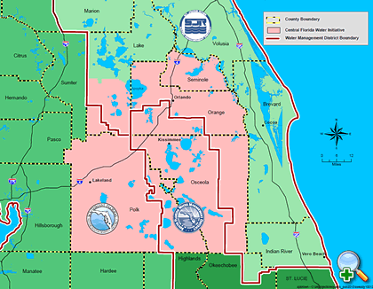
The Central Florida Water Initiative is an area of Florida around Orlando that “does not have enough water.” Could they use ours?
We keep hearing: “Water is the new oil.”
This is hard to believe when one lives in Martin County and watches the destruction from too much fresh water into the St Lucie River/Indian River Lagoon from canals C-23, C-24, C-25, C-44 and releases from Lake Okeechobee. According to the Florida Oceanographic Society, 1.7 billion gallons of fresh water per day is sent/wasted to the Atlantic Ocean and Gulf of Mexico through the St Lucie, Caloosahatchee and other South Florida canals.
Well, there is one area of our state, not too far away, that is running out of water. Today, these counties are part of what is called the “Central Florida Water Initiative,” CFWI. They include: Seminole, Orange, Osceola, Lake, Polk, Brevard and Volusia.
I must divert for a moment because this is really something as this area holds the “headwaters of the Everglades.”
“Shingle Creek,” in Orlando’s Orange County, is generally considered to be the northernmost headwaters of the Everglades’ watershed. This is an area you probably drive right past upon a visit to Disney World. It was named after the cypress trees that were used to make roof shingles in the pioneer era and beyond.
In the 1960s and 70s, after the cypress trees were cut for the shingle industry, Shingle Creek and the other surrounding streams and lakes’ water-levels were “brought down” in order to allow more development. One of the ways this was achieved was through the Army Corp of Engineers’ canalization of the once long, serpentine, Kissimmee River. Canalization of the Kissimmee not only helped lower the lakes so they could drain, but also created lands along the now straight canal for ranch and real estate development.
Today, as we know, all that now dirty, unfiltered, water shoots down the Kissimmee into Lake Okeechobee and then is redirected to the St Lucie and Caloosahatchee so the sugar and vegetable farmers south of the lake have “dry feet,” as well… Thankfully, parts of the Kissimmee have been restored and society recognizes the canalization of the Kissimmee River as an environmental disaster. Our disaster.
Nonetheless, there is no way to completely undo what we have done, so now south of Lake Okeechobee and north of Lake Okeechobee often does not have enough water, while the Northern Estuaries sometimes HAVE TOO MUCH.
Where am I going with all this?
So fast forward, it is now 2014, and as I mentioned the “headwaters of the Everglades” and the counties surrounding it are literally “running ” out of water.
This is why the Central Florida Water Initiative, mentioned at the beginning of this write up, was formed.
An excellent article entitled “Central Florida Water Initiative, “A Regional Response to Avoid a Pending Crisis” written by attorneys Michael Minton, Laura Minton, and John Wharton, of Dean Mead for the Florida Engineering Society succinctly explains the history, goals, and future for the CFWI. I would like to share some of this article.
The article notes how from 2007-20012, the St Johns, South Florida, and Southwest Florida water management districts undertook an assessment of available groundwater for the seven counties listed at the beginning of this blog, noting insufficient quantities for the area’s projected growth— projected to be 6.6 million by approximately 2050. This would include an addition of 3,000,000 people to the population today.
Thus over time and through much coordination and work the CFWI was born.
After deep explanations, the article explains that the CFWI’s conclusions and recommendation include the following concepts: water is undervalued; continued use of just groundwater sources would cause unacceptable environmental impacts to the Floridan aquifer; the importance of conservation; the importance of alternative water sources, its expense and the coordinated regional effort that would be required to achieve such for the future.
The CFWI is obviously a complex effort thus I will not attempt to go into too great of detail. If you are interested, you can read more about it here:
What I must mention is that on the final page of the Dean Mead article something very interesting is stated:
“The Solutions Planning Team’s (STP) report is scheduled to be made public in Fall 2014. Once the findings of the SPT are approved by the Steering Committee, it is anticipated that the findings will be made available to the Central Florida Legislative Delegation. The collection of uniquely talented individuals who have volunteered their time and effort to serve on the committee has yielded many novel and creative concepts. Some of the creative opportunities look beyond the CFWI’s geographic boundaries and contemplate transmission of surface water from regions with excess water supply, to the detriment of their environment, to Central Florida to supplement the existing supply. These creative and innovative options are the type of out of the box thinking that long-term solution Florida’s water strategy and policy will require…”
I wonder and I hope they are talking about “us…”
____________________________
The Article, Central Florida Water Initiative, A Regional Response to Avoid a Pending Crisis by Dean Mead, was published in the JOURNAL of the Florida Engineering Society, to access this article you must be a member: (http://www.fleng.org/pubs.cfm)
Sunset over St Lucie River with storm clouds and rainbow. (September 10, 2014 by Todd Thurlow.)
At another time of my life, I lived in North River Shores, in Stuart, looking west over the wide beginning branch of the North Fork of the St Lucie River. I remember feeling like I was seeing Stuart for the very first time, although I had lived here “my whole life.” The sunsets were the most beautiful I had ever seen. Amazing… Like the canvass of the Creator, night after night.
I thought to myself, why haven’t I seen this before? Sewall’s Point, Stuart, Jensen Beach all front row seats to this phenomenon of nature…but North River Shores? This view is beyond anything one can experience anywhere in Martin County…
The years passed, life changed, and I no longer reside in North River Shores, but ironically my brother’s family lives directly across from where I did reside. And my brother still looks upon this sky, that upon occasion, will bring you to your knees in worship of something beyond this world.
My “little” brother’s name is Todd, (http://thurlowpa.com) and he took this photo Wednesday, September 10th.
I feel the rainbow in the storm clouds is most symbolic. There is alway hope, even in the brewing, impending storm…
The University of Florida has been charged by the Florida Senate with a technical review of options to “move water south,” 2014/2015.
One of the projects that was born from Senator Joe Negron’s led “Select Committee on the Indian River Lagoon and Lake Okeechobee Basin” Senate Hearing of 2013 is linked to an agreement between the Florida Senate and the University of Florida Board of Trustees. The project title is a “Technical Review of Options to Move Water from Lake Okeechobee to the Everglades.”
The project has been given $250,000, the “project period” ends March 1, 2015, and will be led by Wendy Graham of the UF Water Institute. Other great minds of our state university system will also be a part of this process. (http://waterinstitute.ufl.edu)
As a Florida Gator myself, Class of 1986, I am hopeful. Nonetheless, I recognize that the university is historically tied into the politics of development and agribusiness that has been part of the destruction of the St Lucie River/Indian River Lagoon and our state.
My Grandfather Henderson was an agronomist/soil scientist, UF graduate, and teacher. He taught citrus magnet and UF Bull Gator, Ben Hill Griffin. He was very proud of this. When I was kid and my grandfather would drive me from Gainesville to Stuart, he would try to make me memorize every scientific name and genetic history of every cow we passed along the Florida Turnpike, and also tell me what quality of soil was located where the cow was standing.
My grandfather, my mother’s father, was a farm boy, had lived through the Great Depression and was not thinking about “preserving” this state; he was thinking about using it for the “betterment of mankind, for progress.” I, on the other hand, have lived a kinder, gentler life, and so my goal is to save the beauty and nature of the state for future generations, and I see its connection to property values. My grandfather probably figured “what good are property values if there is no food on the table?”
These ideological conflicts still exist today just in a different way. For the University of Florida and people like my grandfather, historical friendships and connections run deep and it is difficult to not be affected by such in ones ‘ judgement, even if one is a scientist…
But in my opinion, today when thinking about this “conflict, we must think more about the future….and the future of this state is inexorably tied to the health and quantity of its fresh water resources…also we must trust and support those who have been charged to complete the project.
University of Florida was founded in 1853.
Yes, in spite of the political intricacies, I can think of no better place for a review of “moving water south,” than the University of Florida Water Institute.
According to engineer Dr Gary Goforth, of Stuart, now independent but formerly of the South Florida Water Management District, the UF team is “highly qualified.”
He states: “I am optimistic the review team will produce an excellent report after meeting with interested members of the public if they can make recommendations that may be in conflict with existing state and federal agency positions and policies. This is often difficult for agencies that depend on continued State funding as does the University...”
Kevin Henderson, also of Stuart, (no relation to my grandfather) engineer, and long-standing estuary advocate and Rivers Coalition member says:
“I believe the folks at UF understand the issues and will have a good handle on options that will work, could work, and will not work.
So my view is- let them do it, don’t believe everything you read in the papers, and read the scope below with an understanding of the political document it has to be to even get started.
What would be really useful is the Corps making clear that HHD cannot be made into a legal dam without having a very large flood discharge outlet that does not exist today.“
Me? I just want to wish Wendy Graham’s team luck, and let them know that I for one am rooting for them.
Below is a copy of the agreement between the Florida Senate and UF Board of Trustees. This is important for everyone to read.
Before I close, I can’t resist yelling out loud for all the souls of history and future generations to hear: GO GATORS!
SFWMD’s simplified publication list of RESTORATION PROJECTS, 2014.
If there is anything I believe in, it is the “power of the people,” and it has given me great pleasure to watch this American principal at work over the past year. For me, presently there is nothing more evident of this than a small, simplified pamphlet that was officially released at last week’s Water Resources Advisory Commission (WRAC) on Thursday, September 4th, 2014; it is simply entitled RESTORATION PROJECTS and could fit in your pocket it you folded it in half.
This little pamphlet was greatly inspired by the people, the river protesters in particular, at a meeting that occurred in September of last year and took place at Indian RiverSide Park, in Jensen Beach. At this meeting the WRAC met for its regular meeting within the South Florida Water Management District, but also to hear the voices of the protesters in light of the toxic releases from Lake Okeechobee during the summer of 2013. In August of that year over 5000 people had protested at the St Lucie Locks and Dam. The District took notice.
As did the press….
You may recall Kenny Hinkel’s video that went viral of many people at the meeting on their cell phones? You may remember locals speaking before the WRAC asking for clarity, in understanding exactly “what and when” the SFWMD was doing to “save our river.” You may remember people being mad. You may remember myself and others begging for a simplification of presentation as the presentations from the District are so erudite only a scientist can understand them.
Note the top priorities have to do with attempting to “send Lake O. and others waters south through the Tamiami Trail area and the Indian River Lagoon South projects in Martin and St Lucie County for water storage from polluted local canals. Great. And it may have been that way before, but we needed to see it on paper!
Many people deserve credit for this simple but huge accomplishment, the River Warriors and SFWMD staff in particularly but I must note that on the day of that meeting, it was Chief of Staff, Dan Delisi, who called me aside after that meeting and said: “That simplification idea…so the public can understand….that is a good idea….we will work on that.”
And they did.
Also, the queen of the publication is Ms Temperince Morgan who compiled tons of information and put it before the WRAC to be digested and fought over and did it with a smile.
And the greatest of all, the pearl in the oyster created by that constant irritation, that grain of sand, is the people!
You created this, you demanded this. You insisted your government talk to you in such a way that you “get it.”
Corruption is easily shrouded in complexity. Simplicity is the light, our light for a cleaner and healthier St Lucie River and Indian River Lagoon.
The Jupiter lighthouse, built in 1860 remains a stunning landmark as one passes over the confluence of the Loxahatchee River and southern Indian River Lagoon. (Photos by Jacqui Thurlow-Lippisch, 2014.)
This week I have been watching a high school friend’s seventh grade daughter, Hannah, so I have been particularly “adventurous,” taking advantage of sharing some of the cool places to visit, right in “our own backyard.”
One such place visited this past weekend was the Jupiter Lighthouse. The first time I toured the Jupiter Lighthouse I was five and attending St Mary’s Kindergarden in Stuart. The teacher and guide walked our class up the hundreds of twirling stairs to pop out at the top and see a panoramic view of the Atlantic Ocean and Loxahatchee watershed. We were awed!
I can still remember this experience. In fact for whatever reason, as a child, I believed the lighthouse could talk and that people sat up in the lighthouse in black leather chairs, men with cigars I recall, and together with the lighthouse “invented words.” This childhood idea has stayed with me through out my lifetime and every time I drive past the lighthouse, I remember it…
But I never actually went back until last weekend.
So 45 years later, attending with Hannah, the lighthouse still held its magic.
The lighthouse was built in 1860 to guide sea captains along the Atlantic’s treacherous waters. Its “Fresnel lens” shines 23 miles out to sea. The land around the lighthouse is located on a military reservation that was designated during the Indian Wars. Today the lighthouse is the region’s “oldest active building.”
Original Fresnel lens.
It’s light was quickly snuffed out during the Civil War, 1861-1864, but thereafter put back in place and still shines today as the only lighthouse in Florida using its original lens. The lighthouse has been through fires, an earthquake, multiple hurricanes, the Indian Wars, and World War I and II. It has seen the entire growth of modern-day Jupiter. In 2000 it was restored and today, honestly, looks almost brand new.
View looking east of Atlantic Ocean and confluence of Loxahatchee River and S. Indian River Lagoon –from inside Jupiter Lighthouse.
For Hannah and I it was most interesting to note that the lighthouse sits atop an 45 foot sand dune/Indian shell midden lending to its prominence. Another interesting thing we learned afterwards from Facebook exchanges was that the Jupiter Inlet today is not in its original location. When the lighthouse was built the inlet winded through today’s Carlin Park about a quarter-mile south of today’s ACOE’s straight shot into the Loxahatchee River.
The Loxahatchee River, along which the lighthouse sits, was Florida’s first designated “Wild and Scenic River” and translates as “river of turtles” in Seminole. (There used to be hundreds of Green turtles in the area.) Unfortunately for the native peoples the turtles were over harvested and according to local historian Bessie Wilson DuBois, 300 of the local Seminoles were trapped right at the mouth of the Loxahatchee and later sent west during one of the Indian Wars.
The remnants of the original native peoples who lived in the area for thousands of years before their destruction by Europeans, can be seen in their earthen mounds under, and around the lighthouse. (Most famously, under the DuBois Pioneer Home across the river.) These shell mounds, formed by thousands of years of shellfish consumption provided high sights for these ancient people to take watch and a place in some cases to bury their dead.
Native American tribes.
Most of these sacred places were used by the expanding European culture to make roads. Today they are protected historical sites reminding us of a culture that lived more in harmony with nature rather than trying to overpower it.
The highlight of our visit was when Hannah and I walked to the top of the lighthouse with our tour group which included kindergarten aged kids. I thought about how much time had passed since I myself walked to the top of the lighthouse at that age, I thought about my friend’s daughter growing up in a different but somehow similar world to what I grew up in….
At the very top, Hannah and I were exhilarated. Inspired! We walked all the way around in amazement.
Then it was time to go…
On the way down, I said “Hannah you don’t mind if I say a few word to the lighthouse before we leave do you? She smiled.
I turned my head, held tight to the railing, and whispered: “Good to see you agin Mrs Lighthouse, you are looking pretty good for 154 years old.”
I was silent, and then I swear, I heard her say: ” You don’t look so bad yourself for 50, but please, don’t wait another 45 years to say hi.”
Jupiter Lighthouse sits a top an ancient Native American shell midden.
Sugar Hill Sector Plan and Airglades Airport’s location in reference to Lake Okeechobee, (Maps, iPhone, 2014.)
Since last week, you may have seen press on “Sugar Hill and Airglades Airport,” a land use change proposal located in Hendry County southwest of Lake Okeechobee. This is a highly controversial, approximately 67 square miles, of present “farmland” that could change to residential, (up to 18,000 homes), and commercial lands, built around an airport that is already in place with the potential to expand.
Just for comparison, the Airglades Airport runway is 5900 feet long while Witham Airport’s in Stuart is 5800 according to my husband Ed. (http://en.wikipedia.org/wiki/Airglades_Airport)
Anyway, this morning I do not have time to debate this issue in detail, but I will say of course that it is a true “game changer.” I wanted to SHOW where these lands are located in reference to lands that are still available for purchase by the state of Florida due to an option you may have heard of as well.
If purchased, these “option” lands would be key in Everglades restoration from Lake Okeechobee to the Everglades and restoring some pathetic remnant of its historic flow.
Presently, the state does not want to buy these lands because politicians claim there is no money to maintain them and if they were bought the lands will just end up “sitting there,” at great expense until a possible time they could be utilized in the future, like 2060.
This argument may sound “reasonable” but in order to save the Everglades and the St Lucie River/Indian River Lagoon, purchasing these lands is critical and should be done “now” because if these lands are not purchased “now,” as the Sugar Hill Sector Plan shows, their land use could be changed and then the lands will be too expensive for the state to ever purchase. Market value for agricultural lands is less than residential. Sometimes life demands you spend money now to save in the future.
So, just so we know where we are talking about, where are these Sugar Hill and Airglades lands located? See map below.
Airglades Airport and the Sugar Hill Sector plan are located south west of Clewiston by about five miles on the west side of Lake O along Hwy. 27.
They are located on Highway 27 west of Clewiston. Highway 27 runs through the Everglades Agricultural Area south of Lake Okeechobee connecting both coasts. The Airglades Airport and Sugar Hill Sector Proposal are located right before the highway shoots north. See red dots above and below. The 67 square miles of Sugar Hill Proposed Sector lands are “around” the airport. I do not know exactly where, but I would think mostly south.
At closer view, one can see the Airglades Airport amongst the sugar fields.
Now if we look at a partial map of the option lands we can see that the Airglades Airport and Sugar Hill Sector Proposal are located in lands that were designated for purchase to one day benefit Everglades restoration for posterity. (Dark green is of “most importance” and yellow is of “importance,” both are option lands…)
Map showing option lands close to Clewiston.
Overall EAA option lands:
Option Lands marked for purchase for Everglades restoration under former Gov. Charlie Crist. The deal fell apart due to politics and the financial crisis of 2008–a much smaller land purchase ensued.
OK…so how would this fit into the Plan 6, River of Grass restoration? Please keep in mind Plan 6 and all “plans” are fluid as they have not happened yet…The amount of water we are talking about it almost beyond comprehension and requires great areas of land beyond lines on a sheet of paper. So even though this Plan 6 chart concentrates flow between the Miami and New River Canals the lands west of this area where Sugar Hill would be located are part of the overall restoration plan for this area as we can tell from the option lands maps above.
Plan 6.Plan 6 flow, River of Grass.
In conclusion, and to repeat myself: all the lands marked as option lands are important for the overall Everglades/Northern Estuaries restoration project. The Sugar Hill Sector Plan, if successful, is setting a precedent for changes in agricultural land use in Florida. There may be no turning back on this at this point as the Scott Administration gutted the Department of Community Affairs that used to keep such land use changes in check. As usual the state of Florida has put development before restoration of natural lands and water’s protection.
When Florida’s future waters are just one big toxic algae bloom, and people do not want to live here, I wonder if some of our politicians will wish they had voted another way? Oh but they will be dead like me, so I guess it doesn’t matter….
It does matter. It matters almost more than anything in the world. Please make your voice known and let’s leave something to the children of the future other than cookie cutter homes.
The collective teamwork of the SLR/IRL River Movement has had a tremendous effect on state agencies such as the ACOE and SFWMD. “KEEP THE GATES CLOSED!” (Photo of River Warrior and River Kidz mom, Cristina Maldonado, donning her homemade protest shirt at the St Lucie Locks and Dam River Rally. Photo Jacqui Thurlow-Lippisch, 2013.)
Today I want to share what I consider a huge recent success of the River Movement and our ability to network and work together to protect our St Lucie River/Indian River Lagoon.
On August 25th, Jensen Beach activist Jackie Trancynger sent out an email blast featuring a photograph taken by Paul Shidel of an awful looking algae bloom he found while photographing birds at Port Mayaca. Port Mayaca is where structure S-308 is located that allows water from Lake Okeechobee to be released into the C-44 canal to the St Lucie River/Indian River Lagoon.
Here’s the photo. You may recall reading about it in one of my previous blogs or seeing it in an email exchange:
August 24, 2014 photograph of blue-green algae bloom east of S-308, Lake Okeechobee/C-44 Canal area/ (Photo courtesy of Paul Shidel.)
So anyway after I saw the photo, I called Jackie Trancynger and got Paul Shidel’s email in order to verify the location of the bloom-certainly appearing to be toxic algae. Paul not only verified the location but provided a map!
Map of algae bloom’s location on east side of S-308, C-44 canal. (Paul Schidel.)
On Tuesday, August 26, I participated as I have for almost two years now, in the ACOE Periodic Scientists Call in my capacity as an elected official from the Town of Sewall’s Point at the invitation of Ms Deb Drum, who oversees Martin County’s Ecosystem Restoration & Management Division.
During this call I sent Paul’s photo and map to the ACOE stating concern that if S-308 were opened this possibly toxic algae would head straight into our SRL/IRL.
Then an amazing thing happened..
The ACOE ask the Department of Environmental Protection (DEP) to test the algae.
Yesterday, Deb Drum from Martin County reported that the testing came back positive as “Microcystis, a toxic blue-green algae.” The county in turn notified the ACOE that the algae exists in that location to document their concern. If the ACOE were to open the locks at S-308, the algae could travel downstream with the water flow into the SLR/IRL. This knowledge could actually make a difference in a decision of the ACOE to open up those structures.
Wow. Thank you Paul!
I have complained before on the ACOE call about toxic algae being released from Lake Okeechobee as the SLR/IRL does not seem to “go toxic” from its local canals, but only when Lake Okeechobee’s waters are unleaded to our shores. Toxic algae has been seen in the area between S-308 and S-80 many times but we need to start documenting this. Documentation is a powerful tool in changing the tide of destruction.
So thank you for your teamwork! Together we can help KEEP THEM CLOSED! The “Gates of Hell” that is…
Subject: Lake Okeechobee, Okeechobee/Glades/Hendry/Palm Beach/Martin Counties: Florida CyanoHAB Tracking Module has received a record update
On August 27, 2014, Florida Department of Environmental Protection’s Southeast District staff sampled an algal bloom found in Lake Okeechobee. A single grab sample was collected of surface scum at the Port Myakka Lock (C-44.) Following are the laboratory results for this sample:
Result: Class Toxin potential * The dominant taxon was: Microcystis aeruginosa Class Cyanophyceae yes
Other taxa present: Dolichospermum circinale ** Class Cyanophyceae yes Pseudanabaena sp. Class Cyanophyceae undetermined Eudorina elegans Class Chlorophyceae – Pediastrum simplex Class Chlorophyceae – Glenodinium sp. Class Dinophyceae
* Information based on literature searches and personal communications; information is continually being updated. “Undetermined” refers to specimens for which the lowest practical level of taxonomic identification is genus and some, but not all, species within that genus have the potential to produce toxins or toxin information not available for the identified species but is available for genus level.
Bottle nosed dolphin photograph. Prior to 2013, HBOI reported there to be between 800-1000 bottle nosed dolphin in the IRL. (Photo courtesy of Oxstyletech, public photos.)
By now, just about everyone has heard that the beloved dolphins of the Indian River Lagoon are struggling with health issues exacerbated by poor water quality and compromised immune systems.
I wrote a blog on August 14, 2014 dealing with these issues. Today’s blog goes one step further as since one week, yet another sickness is being reported. It’s called “morbillivirus,” a deadly virus related to human measles and canine distemper in dogs.
At this point, it has only been reported in the northern central lagoon, mostly in the Brevard/Volusia areas.
Just to set the record straight, as all of this becomes very confusing, in 2012 and 2013, at the height of the northern central Indian River Lagoon’s crash and 60% of their seagrass die off, NOAA, a federal agency, declared two marine mammal UMEs or “Unusual Mortality Events,” for the area of the northern central lagoon.
The first was for manatees that were dying by the hundreds and the second was for IRL bottle nosed dolphins that were also dying at an alarming rate. In both instances the state and federal agencies declare the deaths a “mystery,” even though every second grader can figure out if 60% or more of your food source habitat has suddenly vanished and the waters of your home are toxic with an unpresidented “super bloom” and brown tide of often toxic algae, it just may kill you….
To pull back from my rant, so yes, in 2013, NOAA declared a UME for IRL bottle nosed dolphins in the IRL.
Sadly and ironically, almost simultaneously though slightly earlier, NOAA had declared another UME for the bottle nosed dolphins in the Atlantic Ocean along the eastern United States. This time thought, the agency knew that the mortality event was due to morbillivirus, sickness related to measles and canine distemper in dogs. (http://www.cnn.com/2013/08/27/health/noaa-dolphin-deaths/index.html) Many hundreds of ocean dolphins have died and therefore if an Atlantic bottle nosed dolphin beaches along the Atlantic Coast (Treasure Coast included) by law it must be euthanized so as not to spread the disease to other dolphins. Specifically here, dolphins of the St Lucie River/Indian River Lagoon.
The two species are related but genetically distinct. Most IRL dolphins are thought to remain in the lagoon…
Unfortunately, about a week ago, as the first two links in this blog show, it was reported that the morbillivirus is now killing dolphins in the northern central lagoon. According to WESH 15 dolphins were found dead in August, 8 of those were determined to be caused by morbillivirus. As one would expect, the disease is killing dolphin calves.
I am no scientist but I am very interested in bottle nosed dolphins as I was a volunteer at Harbor Branch in the marine mammal department and one of my best friends, Nicole Mader works for the Dolphin Ecology Project and photo IDs all of the dolphins in the St Lucie River/Southern IRL.
I also have had the opportunity to meet and correspond with Dr Gregory Bossert who now works at the Georgia Aquarium and is one of the foremost scientist on documented sickness in the Indian River Lagoon.
Morbillivirus has hit the lagoon and Atlantic bottle nosed dolphins before. Dr Bossert when he worked at Harbor Branch, wrote a paper along with others studying the disease from 2003-2007 in Charleston, South Carolina and the IRL.
According to the paper:
“Between 1987 and 1988 an epizootic of morbillivirus infection characterized by widespread mortality occurred in bottle nosed dolphins along the eastern coast of the US. An estimated 2500 deaths occurred. Stranded dolphins were found along the cost adjacent to the IRL and inlets connecting the ocean to the estuary. In retrospect serological testing of archived samples indicates that morbillivius infections had been present in the IRL since at least 1982.”
The paper goes on to read:
“The most important finding in the study was the detection of antibodies against DMV and PMV in dolphins from the IRL in absence of an epizootic and typical morbillivirus associate pathologic lesions.”
Hopefully this means that some of the IRL dolphins may have an anti-body to help them fight this next wave of morbillivirus along the eastern coast that has now entered the Indian River Lagoon.
Historic postcard ca. 1910 “Growing Sugar Cane.” Postcard courtesy of Sandra Henderson Thurlow.
The problem with “Sugar” is its location.
The war cry of the Rivers Coalition is “Move the Water South!”
Right now, this is not possible as the majority of the lands south of Lake Okeechobee are “blocked,” “taken,” “owned,” by the sugar industry. The 700,000 acres of the Everglades Agricultural Area (EAA) consist of mostly sugar cane on prime agricultural muck lands, some of “the most productive in the world.” “Cha, Ching!”
These lands that formerly allowed sheet flow from waters north of the lake to overflow and to nourish the Everglades have been drained since the early 1900s on a small level and then extensively after World War II and the Cuban Revolution. It was earlier in 1923 that Lake Okeechobee was first connected to the St Lucie River/Indian River Lagoon by the Army Corp of Engineers (ACOE) through the construction of the C-44 canal allowing massive drainage from Lake Okeechobee into the St Lucie River/IRL keeping the lands south of lake “dry.”
EAA. SFWMD map.
According to David McCally in his book The Everglades, An Environmental History published in 1999:
“What drainage accomplished in the Everglades was the conversion of a derelict system to a developmental one. A developmental system results when the natural world is converted into the basic infrastructure for intensive human development. Ironically, the modern American version of development is actually rooted in extensive destruction, but since that destruction does not lay waste human achievements, it is often ignored, and the close relationship between human development and the destruction of the natural world is overlooked.”
Proposed Everglades canal system/drainage, state of Florida, 1914.
Perhaps in the past this “destruction” was overlooked, but not today. A new value system has arisen. The people want the natural systems of the Northern Estuaries and the Everglades “to return.”
In my opinion, part of returning this paradise is finding a way for a third outlet from Lake Okeechobee. There are many parts to the puzzle and this is one of the major pieces.
It will be interesting with the governor’s race warming up to see what the message is on “moving water south.” The University of Florida study sponsored by Senator Negron’s Senate Hearing on the Indian River Lagoon and Lake Okeechobee Basin will not be finished until Spring of 2015. Therefore the candidates will have to speak on their own.
Rick Scott and Charlie Christ have basically kept silent on sugar/water issues so far. At some point, both, who have close ties to the sugar industry, will have to speak on the difficult position of sugar blocking the Everglades’ waters and destroying the northern estuaries.
Let’s sum it up now, before I start to sweat and need a sweet tea.
“Location, location, location….” Some things never change, but some things do, and that is up to us.
First major canals south of Lake Okeechobee, Miami and New River 1911. Drawing shows marsh lands, “swamp,” of the Everglades.
Color graph showing land use and development in South Florida by 1972 made possible by drainage and re-plumbing of Lake Okeechobee waters to the northern estuaries. (SOFIA, Robert Renken team 2000.)
To understand the impacts on the St Lucie River/Indian River Lagoon, it is necessary to look in beyond our boarders. One of the most telling documents helping to explain why the St Lucie River/Indian River Lagoon is forced to take the over flow water of Lake Okeechobee (which in some years, since 1923, has been above 2,000,000 acre feet) is a document entitled “Synthesis of the Impacts of 20th Century Water Management Land Use Practices on Coastal Hydrology of South East Florida,” by Robert Renken and other scientists for the 2000 Greater Everglades Ecosystem Restoration Conference.
Today I will show parts of this document as “food for thought.”
Chart 1, 1900.
As one can see above, in 1900, Lake Okeechobee overflowed naturally to the Everglades to Florida Bay. The green on the eastern coast was a Florida forest.
Chart 2, 1953.
By 1953, the year after my Thurlow grandparents came to Stuart from Syracuse, New York, the Everglades Agricultural Area, (EAA), just south of the lake had caused the destructive redirection of Lake Okeechobee waters; this water was directed to the northern estuaries, the St Lucie River/Indian River Lagoon on the east, and to the Calooshatchee on the west. More agriculture can be seen in dark brown along the eastern coast and south to Homestead. Forests in some areas remain (green). The yellow is urban development. There is some urban development but it is not extensive.
Chart 3, 1972.
By 1972, when I was 8 years old growing up in Stuart, the Everglades Agricultural Area (EAA) now mostly sugarcane, south of Lake Okeechobee, had morphed to gigantic proportions (dark brown), agriculture had also expanded along the eastern coast, and coastal development (yellow) had grown and moved into the eastern Everglades.
Chart 4, 1995.
By 1995, when I was 31 years old, and teaching English and German at Pensacola High School, the EAA had achieved its 700,000 acreage south of the lake, and although there remained extensive agriculture (dark brown) along the east coast, excessive urban development had taken over many of these lands (yellow.)
Today, there is nothing but more rapid population growth projected for this area. There were 5,564,635 inhabitants of the Miami-Dade metropolitan area as of the 2010 Census; it is the most populous in Florida, and southeastern United States. It is the eighth-most populous area in the entire United States. (http://en.wikipedia.org/wiki/Miami_metropolitan_area)
For me, this rapid population and agriculture growth is rather depressing, but I will say Ed and I had a great Cuban meal in West Miami at Islas Canarias Restaurant over the Labor Day weekend…
At the end of the day, this area is going to need more water. With a growing population, documented salt water intrusion, and sinking aquifer level this part of the county will not stand the test of time unless it has more fresh water. Perhaps they would reconsider re-plumbing the canals making releases to the estuaries?
“Move the Water South” may just start being chanted from Miami…