Tag Archives: Ed Lippisch

Before the Storm, August 27, 2023

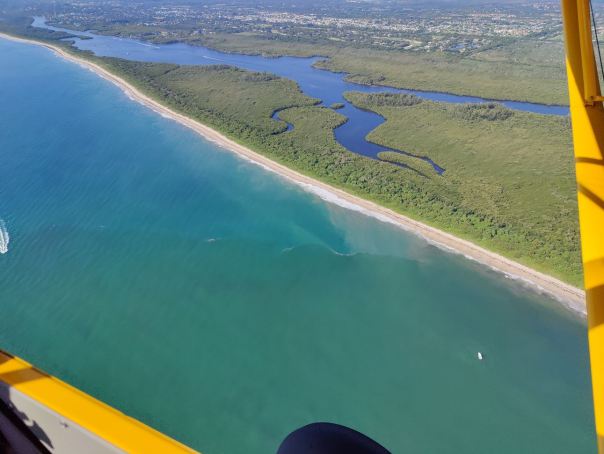
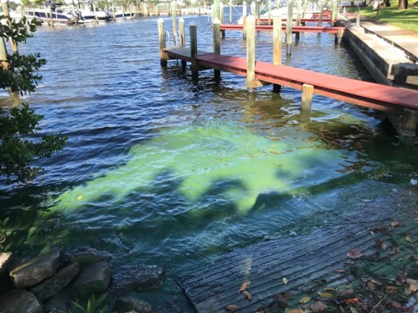
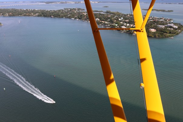
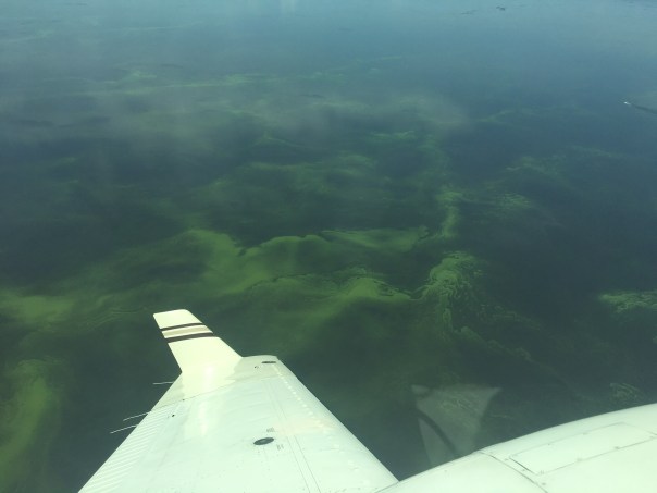
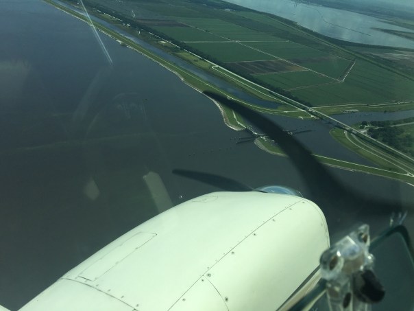
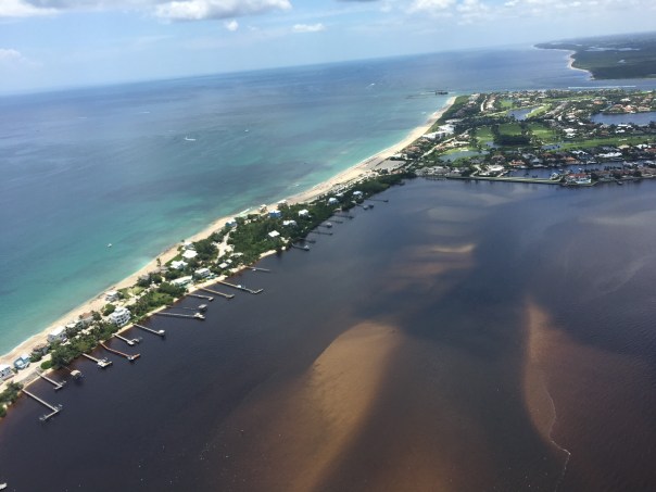
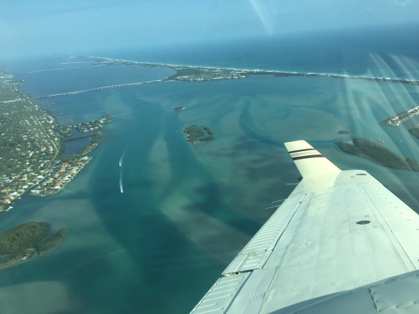
These aerials were taken by my husband, Ed Lippisch, on August 27, 2023 around 12:15pm. Other than an operational  burp from Lake Okeechobee through C-44, it’s canals C-23 and C-24  which drain Port St. Lucie, Allapattah Flats, as well as our Tidal Basin – that are causing the present discoloration and decline in water quality. On a good note, though impaired, seagrass beds are visible near the Sandbar and algae is no longer seen from 1000 feet at Port Mayaca.

As we enter the primary hurricane season it’s unfortunate the alternative canal through the Everglades Agricultural Area once considered by the ACOE  in the 1950s to alleviate the discharges is not in place. If history does indeed repeat itself, we must be prepared for more rain and Lake Okeechobee destruction added to the St. Lucie River/Indian River Lagoon.

We must keep our  eye on lake O!

Most recent ACOE/SFWMD SLR update, 8-22-23
Lake O history, ACOE/SFWMD

Rain and runoff plume exiting St. Lucie Inlet Visibile seagrasses and macroalge Sailfish Flats Sewall’s Point between the St. Luice and Indian RiverPeck’s LakeSL Inlet w/ plume

Sailfish Point on Hutchinson Island is next to St. Lucie Inlet  S-308 at Port Mayaca C44 Canal aka St. Lucie Canal – no algae visible from 1000 feet  


Impact

A picture speaks a 1000 words…

Ed’s RV is having its annual so on August 16, 2023 Ed went up in the SuperCub with Scott Kuhns. It was early morning and lighting limited successful outcome of photographs. Thus I have chosen a just a few, that for me, are impactful in what they say about development and agriculture and our environment.  JTL

Roosevelt Bridge, Stuart, Florida.
North River Shores, Martin County, Florida.
Tradition, St. Lucie County, Florida.
Cutting up the western lands, Tradition, St. Lucie County, Florida.

Sugar’s perfect water-control. Martin County, Florida.
Blue-Green algae in St. Lucie Canal (C-44), Martin County, Florida.
S-308 at Port Mayaca, St. Lucie Canal (C-44), Martin County, Florida.
Ed as a passenger over Lake Okeechobee, SuperCub of Scott Kuhns, 2023.


Continue to Call Out the Bad Actors-Toxic Lake Okeechobee

https://eyeonlakeo.com Todd Thurlow, 2023-06 Sentinel-2 L2A True color

Jacqui, you spoke for the water, for the water had no tongue. And with faux righteousness, Florida’s leaders attacked you. God forbid you call out the bad actors…” 

“Bad scene this morning, It’s the whole lake covered.” Toxic Lake Okeechobee. Professional pilot Dave Stone 6-24-23 of Ft. Meyers.
“Lake Okeechobee is really lit up around Pahokee.” Ed Lippisch, 6-23-23.


“The cyanobacteria is now on inside of S-308 Port Mayaca, Lake O.” Ed Lippisch 6-23-23.

S-80 St. Luice Locks and Dam C-44 Canal. Discharge of “basin” waters 6-23-23, but no Lake Okeechobee water.
“St Luice Inlet post rains 6-21-23.” Dr. Scott Kuhns


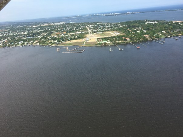
St. Lucie River dark with runoff and C-23, C24, C-44 but no Lake O.

LAKE OKEECHOBEE: 14.56 FEET

Lake Okeechobee on 6-26-23 is at 14.56 feet https://eyeonlakeo.com. TT3

“We will continue to call out the bad actors.” JTL

CSFcanal systems discharges polluted water into SLR. SFWMD
SFWMD 6-20-19


“In Full Bloom” Documentation Lake Okeechobee, Early June 2023

Thank you my husband Dr Ed Lippisch our eye in the sky. And thank you to my brother Todd who alerts us through his website http://eyeonlakeo.com when to fly. June 1st we entered hurricane season. If a storm causes the lake level to rise significantly there is a real possibility the ACOE will discharge. LOSOM an updated lake schedule that would be more beneficial to the estuaries has been delayed. Be ready. Make yourself heard.

Ed’s Visual Update 59 days after discharges begin

  1. Documenting the Discharges 2023

These aerials were taken today, March 22, 2023, around 10:45 am. High tide crested at 11:09 am. Thank you to our eye in the sky and the apple of my eye, Ed Lippisch for consistently photographing the St Lucie River/Indian River Lagoon. Also included is S-308 at Port Mayaca, Lake Okeechobee-checking for algae.

We continue  to document the discharges.

This year the ACOE began discharging 500 cfs on January 22, 2023. Today is 59 days with a few stops decided by Col. Jamie Booth due to visual algae. Thank you Colonel.

TCPALM

Tomorrow there is a meeting at noon at the St Lucie Locks and Dam of the longstanding defenders of the the river, the Rivers Coalition, asking or one could say, demanding, that the discharges to be stopped. We all know that discharges are helpful for lowing a high (now 14.84) Lake Okeechobee, but not for the health of the St Lucie River/Indian River Lagoon, who has unfairly bore this burden for 99 years.

-St Lucie River/Indian River Lagoon with discharges of 500 cfs. Aerials Ed Lippisch.

Most recent ACOE PSC slide up to 3-15-23. Full Power Point: Periodic_Scientists_Call_2023-03-14 2

-S-308 3-22-23 Port Mayaca, Lake Okeechobee – no visible algae at 1500 feet, Photos Ed Lippisch.

Ed’s Aerial Report 33 days after discharges begin 500 cfs, SLR

Documenting the Discharges 2023 -St Lucie River/Indian River Lagoon

Eyeonlakeo.com resource guide to all things SLR

ACOE decision to begin lake o discharges to SRL

These aerial photographs were taken by my husband, Ed Lippisch, on Friday, February 24, 2023 around 1:51 pm during high tide. It was a beautiful day and many boats were fishing over the nearshore reefs. The 500 cubic feet per second discharges are much less noticeable at high tide; the visual loss of seagrass remains. I am sharing all photographs -many are very similar, you can look for small differences.

Please see slides from ACOE Periodic Scientist Call on 2-21-23 for updates on Lake Okeechobee level, red tide on west coast, east coast conditions, and other important information. Periodic_Scientists_Call_2023-02-21

With the hot, dry weather the last few days Lake Okeechobee’s evaporation should be high. Today the SFWMD reported the lake at 15.61 feet. You can see the ecological envelope band in gray below.

PSC 2-21-23

On Friday there was a waring from the Martin County Health Department of an algae bloom at  S-308 at Port Mayaca on the canal side as the Department of Environmental Protection reported this observation from 2-22-23.  

Ed and I continue to document the discharges.

JTL

Ed’s Aerial Report 24 days after discharges begin 500 cfs, SLR

~Ed’s Aerial Report 24 days after discharges begin at 500 cfs via ACOE from Lake Okeechobee to SLR/IRL. Documenting the Discharges. 

My husband Ed Lippisch has asked me to get these photos on-line ASAP. They were taken of the St Lucie River/Indian River Lagoon area around Sewall’s Point, yesterday, February 15, 2023 around 1:25pm. It was an incoming tide about two hours after low tide. I do not have time to go through all the photos so I am sharing all of them. Many are almost identical. Color doesn’t look great. No seagrasses visible. Salinity remains in range according to FDEP. See my brother Todd’s website EyeonLakeO.com for more information.

https://eyeonlakeo.com

https://eyeonlakeo.com

Florida Oceanographic WQ Report Feb 15 2023

Via DEP: South Florida Coastal Salinity Status

Ed’s Aerial Update, 12 days after discharges begin 500cfs SLR

DOCUMENTING THE DISCHARGES 2023
Aerials of St Lucie River/Indian River Lagoon taken February 3, 2023, 1pm “about two hours before low tide.” Florida Oceanographic Society graded the St. Lucie River at an overall “B” for water quality January 26 through February 1st. An “A” for the IRL and a “C” for the SLR west of Sewall’s Point. Since January 22, 2023, the ACOE continues to discharge 500 cubic feet per second from Lake Okeechobee to lower the lake in avoidance of toxic algae blooms predicted in Lake Okeechobee this summer due to Hurricane Ian. The lake is presently at 15.92 feet down from 16.10 feet on January 22, 2023. ~Photographs Ed Lippisch

Ed Lippisch River Warrior documenting the SLR since 2013.

~Aerials below taken 12 days after ACOE began discharging 500 cubic feet per second from S-80 via Lake Okeechobee. Color better  in IRL than SLR.  Of  concern  no  visible  seagrass.

SFWMD’s most recent chart from Environmental Conditions Report: Total Flow to the SLR.

SFWMD’s Operation Position Statement 1/31/23 to 2/6/03 the ACOOE: Ops_Position_Statement_Jan_31_Feb_06_2023

~St Lucie Inlet and Crossroads of SLR/IRL at Sewall’s Point, Stuart, Martin County, FL 2/3/23

Follow Todd Thurlow eyeonlakeo.com for easy to read updates.

SFWMD canal and basin map. C-44 canal is the canal most southerly in the image. When S-308 is open at Port Mayaca, Lake Okeechobee water discharges through the C-44 canal and S-80 into the St Lucie River. This is totally unnatural as the St Lucie was never connected to the lake. The ACOE &  SFWMD are working at a record pace to improve the plight of the northern estuaries through a new lake schedule, LOSOM,  and CERP-Everglades Restoration.

Previous blog post: ED’S AERIAL UPDATE 7 DAYS AFTER DISCHARGES BEGIN 500cfs SRL 

Ed’s St. Lucie River Update, January 15, 2023

-Eye in the sky since 2013, Ed Lippisch I am going to keep this blog post short as I already wrote another today. Yesterday, 1-15-23, at around 1:45 pm, Ed took aerials over the St Lucie River/Indian River Lagoon. As it has been cold and windy the past few days there has been a “Beach Hazards Statement” from the National Weather Service. In Ed’s photos, the rough, turquoise, incoming ocean waters make for a stark contrast against the darker waters of the river. I believe the ocean waters are full of sand and that is what gives the aerials the milky, almost iridescent coloring. Hopefully, the sand is not burying the dormant seagrasses in the Sandbar and Sailfish Flats. Thankfully, there is no dumping from Lake Okeechobee at this time although the river is receiving the other C-Canal water and runoff. I’ll get Ed up in the plane again soon as I have not yet flown in the Van’s RV -and I am not planning on it! 🙂 JTL

SFWMD canal and basin map.

Added 1-18-23. ACOE’s Periodic Scientists Call -Power Point 1-17-23. Periodic_Scientists_Call_2023-01-17

Wrapping up 2022-St Lucie River Update

Tomorrow will be December 31, 2022. Today I share the most recent aerial photographs of the St Lucie River/Indian River Lagoon and even one around Lake Okeechobee.

It was a very cold Christmas season. According to the Stuart News, Stuart logged in at 39 degrees on Christmas Day! The cold system hovered for a few days causing intermittent rain and cloud coverage. These photos taken a few days later after it warmed up -on an incoming tide- reveal that since our last photo session, it appears the river is clearing up thankfully with no discharges from Lake Okeechobee in 2022.

AERIALS

-December 28, 2022 at 8:45am, west of Stuart, east side of Lake Okeechobee, near Barley Barber Swamp and FPL cooling reservoir, -sugarcane burning or a controlled burn??? Photographs taken by Scott Kuhns from SuperCub.

-December 29, 2022 around 2:30 pm, St Lucie River/Indian River Lagoon around St Lucie Inlet, Sewall’s Point, Sailfish Flats, wide view taken over Palm City. Aerials by Ed Lippisch from Vans RV. I am including all photos although some are very similar as each one shows something a little different. Remember you can click on photo to enlarge 🙂

Wishing everyone a very happy and safe New YearEve and let’s continue to work together for a great 2023 for the St Lucie River! 

Visual Update SLR/IRL June 23, 2022

I am very fortunate to have a team of people, “River Warriors” who help me document from sky to water the St Lucie River/Indian River Lagoon. Today, I share photos taken by friend  Mary Radabaugh who overnighted in the area over Father’s Day weekend, June 18-19, 2022. She took amazing photos of nature: live sand dollars, growing seagrasses, wading birds, manatees, and sea turtles. Life is returning to the area.

Next, Dr Scott Kuhns shares five aerials he took the same weekend, on June 18,  around 11:30am. These photographs reveal clear waters with rain runoff plume over St Lucie Inlet and nearshore reefs. There is also a photo of the C-44 Reservoir filled to just over ten feet. This reservoir sits on the C-44 Canal and was just completed this past year as the first major CERP project. It is scheduled to be operational by 2023, although the ACOE is trying for earlier.

My husband, Dr Ed Lippisch, took his plane up yesterday. He shares four photos from June 22, 2022 around 12:30 pm that encompass the estuary from a higher altitude. The darker rain runoff is more visible. The estuary still looks good in the region near the St Lucie Inlet. Higher up the north and south forks the water is darker. There have not been major discharges from Lake Okeechobee in over three years. This is a very good thing and we must continue to make this our goal.

Thank you for all who fight for a clean and healthy St Lucie River!Periodic_Scientists_Call_2022-06-21

ST LUCIE RIVER/INDIAN RIVER LAGOON

I.-Mary Radabaugh, living sand dollar and more life, Sandbar near St Lucie Inlet between Sewall’s Point & Hutchinson Island, 6-18/19-22


I am adding two more wildlife videos 4:35pm, 6-23-22

A. Spotted Eagle Rays at the Sandbar, June 19, 2022,  by my sister Jenny and her husband Mike Flaugh.

B. Trigger Fish, Powers family dock, S. Sewall’s Point, IRL side June 23, 2022.


II.-Scott Kuhns, SuperCub, June 18, 2022 near St Lucie Inlet and C-44 Reservoir, 6-18-22.


III.-Ed Lippisch, Van RV, St Lucie Inlet SLR/IRL  June 22, 2022. 6-22-22.

SFWMD canal and basin map.


Documenting the Discharges, December 2020

Documenting the Discharges, December 2020

Eyeonlakeo

I posted most of these photos on Facebook, but today I will give explanations and document on my blog. From above, our St Lucie/Indian River Lagoon remains beautiful, but we must be sensitive to the losses beneath the waters. These aerials were taken during  a “slack tide” between 12 and 2pm on December 9, 2020 by my husband, Ed Lippisch. December 9th was the last of five days the ACOE stopped discharging from Lake Okeechobee; however S-80 was discharging “local runoff.” (Click on chart above.) Unfortunately, due to high lake level and lack of storage reservoirs, since these aerials were taken, the ACOE has begun ramping up Lake discharges once again. 

Below Lawrence Glenn of the South Florid Water Management gives a comprehensive ecological report covering low-salinities and loss of oyster spat in the St Lucie and other aspects, positive and negative, for the entire Everglades system.

Below is an explanation of aerials documenting discharges December 9, 2020. All photos by Ed Lippisch.

-S-80 at St Lucie Locks and Dam discharging local basin S-80 runoff on December 9, 2020

S-308 at Port Mayaca, Lake Okeechobee closed on December 9, 2020. No algae visible. 

-Plume of along Jupiter Island south of St Lucie Inlet

-Dispersing plume in Atlantic Ocean just past Peck’s Lake in Jupiter Narrows

-St Lucie Inlet -St Lucie Inlet State Park, Sailfish Point, Sewall’s Point, Stuart, Jensen 

-Looking north to Sailfish Flats between Sewall’s Point and Hutchinson Island. This area has greatly degraded since 2013 as far as loss of seagrasses and fishing opportunities 

-The area below, especially around Sailfish Point, was once considered “the most biodiverse estuary in North America” as documented, first, by Grant Gilmore

-This photo reveals seagrass loss across many areas of the Sailfish Flats 

-Another view between Sewall’s and Sailfish Point, a seeming desert…

-Close up, Sailfish Point 

-Sewall’s Point, east Indian River Lagoon 

-Sewall’s Point is a peninsula surrounded by the St Lucie River on west side, and Indian River Lagoon on east side 

Ed Lippisch, selfie. Thank you Ed! 

As you can tell, I have lots of people helping me. Whether it is Ed flying or my brother Todd who provides an incredible easy to read website called EyeonLakeO. You can click below to check it out. The more we know, the more we document, the more we can overturn the destruction of our beloved estuary…

Eyeonlakeo website by my brother, Todd Thurlow. 

The Discharge/No Discharge Difference, St Lucie River/Indian River Lagoon

Looking back through my photo library, I was stuck by the color differences between these photos, so I decided to share….

The first two photos were taken recently, Saturday, December 5, 2020, the afternoon of the same morning the ACOE closed S-80 at the C-44 canal, and S-308 at Port Mayaca, Lake Okeechobee. This seems a bit quick for improvement, but so it was.

The second two photos were taken almost two months earlier, October 17, 2020 a few days after Lake Okeechobee discharges began and C-44 had already been discharging. 

The first three photos, taken by my husband, Ed Lippisch, feature the confluence of the St Lucie River and Indian River Lagoon between Sewall’s Point and Sailfish Point. The final  October 17 photos shows the plume from Lake O and basin runoff passing Peck’s Lake in the Jupiter Narrows. 

We all await the closing of both structures S-308 and S-80 for good. The issue at hand is always the height of the Lake Okeechobee and the story that accompanies such. 

Saturday, December 5, 2020, photo Ed Lippisch

October 17, 2020, photo Ed Lippisch

ACOE- Lake O discharges began Oct 14, 2020 and have stopped temporarily for 5 days, December 5, 2020. This is the most recent inflow chart, SFWMD.

Basin chart 

SFWMD basin map for SLR showing S-308 and S-80 along with other structures.


Tales of the Southern Loop, Miami to Tavernier, Part 3

Tales of the Southern Loop, Stuart to Boyton, Part 1

Tales of the Southern Loop, Boyton to Miami, Part 2

Tales of the Southern Loop, Miami to Tavernier, Part 3A cloud covered sun and a silver moon coated Biscay Bay with a metallic morning light. Today was September 6th, and last night something had changed.

At 3am Ed had shot out of bed. “It’s too quiet in here.”

“It is. That’s why we’re sleeping.” I rolled over putting the pillow over my head.

Ed returned a few minutes later. “The generator stopped working.”

“Oh,”I mumbled and quickly went back to sleep. When I awoke, I found Ed inside the engine room. 

“Good morning,” I said. He looked up.  “So maybe it’s not such a good morning; the generator doesn’t work.” I tried to smile. “But let’s not let this ruin our trip.” 

“Jacqui the oven/stove wont work, the refrigerator and the air-conditioning won’t work, and forget easily charging the phone or computer. We wont be able to anchor out. I was really looking forward to more of that.”

“Yeah, it’s a bummer. But it will still be fun. So we’ll have to depend on marinas to plug in that shore power thing.”

Ed smirked. “I’m surprised you remember- shore power.- In any case, let’s get ADRIFT underway.” Ed closed up the engine room, headed to the helm, and hit the button to raise the anchor. The clickity-clack sound of metal hitting metal echoed throughout the bow and upper helm.

“At least the anchor still works!” I yelled to my Captain. 

ADRIFT crept south in the direction of Tavernier. Once again, it was turning out to be a beautiful day. -Leaving Miami, Biscayne Bay-Card Sound, Biscayne Bay, heading south to the Florida KeysBiscayne Bay was stunning and huge. As we exited the bridge at Card Sound, the waterway started to narrow. Some boats were going very fast. I decided to continue reading my new favorite book, Landscapes and Hydrology of the Predrainage Everglades,  rather than complain. I knew Ed was thinking about the generator…

“Hey Ed!” I yelled towards the upper helm. “Did you realize we have been passing the marl transverse glades?”

“Hadn’t really been thinking about them,”  he replied. 

I walked up the ladder and sat beside him. “I’m going to read to you, OK?”

“In contrast to the unobstructed, rimless, and continuously flowing Peat Transverse Glades, the Marl Transverse Glades were raised spillways, receiving water from the Everglades only during the wet season…The significance of of the Marl Transverse Glades for understanding predrainage Everglades hydrology lies not in their volumes of outflow but instead in their indication that Everglades waters from Rockland Marl Marsh typically rose high enough each year to flow out….” 

“Do you know what this means Ed?” 

“No idea…” 

“It means that when the Everglades were high, like now, during hurricane season, water oozed through to Biscayne Bay not just from areas around Ft Lauderdale, but also from south of Miami  to about Homestead. Today that stretch includes cities like Kendall, Palmetto Bay, Cutler Bay, Naranja, and Homestead Air Force Base.”

“That is pretty surprising.” Ed replied, seeming to be in better spirits. “So – another reason Biscayne Bay doesn’t get enough fresh water.”

“Look at you!” I lovingly mocked. “I’m surprised you remember!”

-Compare predrainage “marl transverse glades” (southern most arrows) pg. 48 & to post drainage developed areas today, pg. 49 -between Miami and Homestead. In predrainage times, this area McVoy calls the “marl transverse glades,” filled up/flowed over with high Lake O and rain waters oozing through to Biscayne Bay. Today due to development, pumps, and drainage this does not occur. Landscapes and Hydrology of the Predrainage Everglades, McVoy, 2011.I looked up from my book. We were in a narrow waterway of mangroves and approaching Key Largo. “Why are those boats going so fast?!” I complained. I couldn’t hold back anymore.

“Because they are allowed to.” Ed replied. “They are in the channel.” Wakes hit up hard against the shoreline.

“They shouldn’t be allowed to go so fast in here. I don’t see how a manatee could survive. And it’s dangerous.” I agonized. 

“Just smile Jacqui!” 

Ed remained silent looking straight ahead. ADRIFT plodded along in repetative wakes while swirling through boat traffic. And I decided – I better just smile…When we arrived in Tavernier, at Mangrove Marina, Ed was once again focusing on the broken generator. Docking was not so easy this time. The winds had kicked up and I was in charge of the lines. I wondered how I’d jump off to the dock if necessary. The engine ground as Ed moved forwards and backwards trying to back into the slip.  We almost smacked into the dock and I yelled loudly realizing the fender was caught on a neighboring house boat. Thankfully, at the last minute, two young dockhands saved us. We thanked them profusely and Ed handed them a tip. 

“Thank God they were here,” I grumbled.

“One day they wont be.” Ed replied. 

“How would I have jumped on that high dock?” 

Ed did not answer. 

“I’m going to open the lazarette to look at this generator again.” I knew Ed would be obsessed until this was resolved.

“OK. I’m going to take a walk,”  I said. I’ll see you in a little bit.”

It was good to get on land and good for Ed and I to take a break from each other. 

Walking the marina, the first thing I noticed, were these weird and beautiful sea anemone like things on the floor of the shallow docking areas. I got down on my stomach to look closer. -It looks like the DREAM OF THE SLEEPING JELLYFISH. Over the course of our stay, I became totally preoccupied with them, checking on them throughout the day and evening. My blog post is above.I continued my walk. Quaint houses lined the streets. “I love it here.” I thought. “There is absolutely nothing like the Florida Keys.” Once my stroll was over, I knew it was time to make it back to see Ed. He was not a happy camper.

“What’s wrong hunny?” I inquired. 

“I’m not sure I will be able to fix the generator, but the marina office gave me a number of a guy to call. It’s Labor Day weekend. I’m not going to bother him.”

“Come on babe, all the days blend together in a place like the Keys. Let’s call him.” Before we called, we decided to take the inflatable canoe out into a small cove. It was so beautiful! The seagrass was lush and Ed thought he saw an otter but it ended up being a mother manatee and and her young calf poking their noses out to breathe.  It was so joyous to just be there next to them as they came up for air. I though about the fast speed boats we’d seen by the mangroves and prayed the mother and calf would be safe. The sun set , we made dinner,  and retired early. I dreamt of sleeping jellyfish and baby manatees.

In the morning I convinced Ed to take a walk, meet my jellyfish, and see the adorable Keys houses. Lo and behold there was a sign! A sign on a red truck that just happened to be the number the marina had given Ed for someone to fix the generator. Ed left a message and Larry Heimer, Blue Earth Marine Services, returned the call! Soon after we met Larry and Wendy. Wonderful people! Ed learned a lot watching and asking questions. Thanks to Larry the generator got fixed!   Ed after the generator was fixed by Larry Heimer and Wendy 🙂Stormy weather forms… I was so happy! Ed was smiling again!

But there was another issue brewing…

We looked up. “Where is this weather coming from?”  

“There’s a system forming,” Larry replied. “You best leave tomorrow if you can.” 

Night fell; Ed and I listened to the band playing.

Lights reflected off the water and I thought about the jellyfish sleeping on their heads on the milky limestone bottom and the thousands of years of time, tide, and water that had formed this remarkable place.

Ed and I watched the heat lightning and toasted our good fortune to find Larry and  Wendy to fix the generator. 

We decided that unless it was really storming, we would head out first morning light….


Lake O Algae Visible Again

You may have seen my most recent Lake Okeechobee post from July 25, 2020? After algae aerials since May 8th, my dear husband, Ed, said he saw no algae. Ed and I had a back and forth -me saying the algae “was hiding.” Hiding in the water column. Ed saying it was gone. Well, guess what? I was correct… 

Today, July 29, only four days later, the cyanobacteria is back. There was one positive to it all. Ed added to his long list of esteemed flight guests, Ft Meyer’s Captains Chris Whitman and Daniel Andrews – the faces of Captains for Clean Water. The east and west coasts of Florida have been advocating together since the days of the Sugarland Rally in 2013. East and west, an important water alliance. 

According to Ed, “the algae was bright and visible over the majority of the western,  and southern-central portion of the lake, but became less dense as one approached Port Mayaca.” 

“Were you surprised the cyanobacteria had returned?” I asked. 

Ed had a very simple answer: “yes.” 

Ed also said it was a great to hosts the Captains. What an honor. 

Below are some of Ed and Captain Daniel’s photographs from Wednesday, July 29, 2020. You will see, with the sun shining, the lake is once again, visibly, full of algae. This is important documentation for the Army Corp of Engineers as we possibly face a very wet weekend. 

Havens and Hoyer diagram from study of cyanophyte movements.Courtesy, Joe Gilio.
Courtesy of Captain Daniel Andrews-off southwestern shore

Courtesy of pilot Ed Lippisch-southern to southwestern shore of L.O.

Father’s Day LakeO Flight

Documenting Algae Bloom in Lake Okeechobee, 2020, 

Algae bloom in Lake Okeechobee from 10,000 feet for a wide view. King’s Bar Shoal left near Kissimmee River and City of Okeechobee. FPL cooling pond on eastern shore near S-308 and C-44 Canal in Martin County. Aerial, Ed Lippisch 6-21-20

On Sunday, before we celebrated Father’s Day with family, once again, my husband and fellow River Warrior, Ed, flew the Baron for necessary time on the engines. As he was walking out the door I asked: “Could you please fly over Lake Okeechobee again? I’m curious about that bloom.”

“OK, but I’m going north first.”  

Ed and I have been documenting this year’s algae bloom since May 3rd

Upon Ed’s return, he told me that this time, the algae bloom appears to be located further north, as well as south. You can see the algae near  King’s Bar Shoal-the  distinct “island” looking  structure, visible now, near mouth of the Kissimmee River. 

These aerials are taken from 10,000 feet, much higher than usual,  so the effect is different. When you seen the “wrinkles” on the water, that is the bloom.

One day, may there be an algae-free Lake Okeechobee, for future fathers and for future father’s kids. 


C-44 Reservoir/STA Aerial Update -June 2020

C-44 Reservoir and Storm Water Treatment Area (STA) 

After weeks of algae Lake O shots, when my husband, Ed, went up in the Baron on June 17th, 2020,  I looked at him and said: “Could you please also take some photos of the C-44 Reservoir and STA for an update? I need a positive fix.”

Thus today’s photos of the C-44 Reservoir/STA in Martin County, off the C-44 canal near Indiantown, share good news. Most important for me, the pictures reveal that many more of the STA cells are slowly getting filled with water -in December 2019 they started with one as Governor DeSantis pulled the lever. One can see many more cells are now filled. When complete, these cells will cleanse tremendous amounts of nutrient polluted water prior to entry into the St Lucie River. The ACOE projects that construction will be completed by next year. It has been in progress for many years and is a” cooperative” between the ACOE (reservoir) and SFWMD (STA) and a component of CERP

Program: Comprehensive Everglades Restoration Plan (CERP)

“Located on approximately 12,000 acres on the northern side of the St. Lucie Canal in western Martin County, the C-44 Reservoir and Stormwater Treatment Area (STA) project will capture local basin runoff…”  ~SFWMD Achieve More Now” 

There are maps and links at the bottom of this post should you like to learn more. Thank you to all over the years and today helping with the completion of the C-44 Reservoir STA as we work to save the St Lucie River.  

LINKS

Computer Generated Model: (https://www.youtube.com/watch?v=4BsC0BoIPJ4

ACOE INFO SHEET:(https://usace.contentdm.oclc.org/util s/getfile/collection/p16021coll11/id/4599)Without

Martin County: “Martin County’s land acquisition efforts, this most critical and important project would not be under construction today.” (https://www.martin.fl.us/land-acquisition)

JTL  Past blog posts

SFWMD FIELD TRIP 2019 (https://jacquithurlowlippisch.com/2019/11/11/a-fly-over-a-field-trip-and-watching-the-governor-activate-the-c-44-sta/)

EARLY FLY OVER 2014 (https://jacquithurlowlippisch.com/tag/c-44-sta-and-reservoir/)

HISTORY: A LOOK BACK TO THE ORANGE GROVES OF TODAY’S C-44 RESERVOIR 1964 AERIALS: (https://jacquithurlowlippisch.com/2015/10/29/a-look-back-to-the-orange-groves-of-todays-acoe-sfwmds-c-44-reservoirsta-1964-slrirl/)

Red Balloon with black dot signifies footprint of former orange groves that became the footprint  of C-44 Reservoir STA approx. 10,000 to 12,000 acres

Algae Overview North, South, East, West LakeO

Because the Baron needs hours on the engine, my husband Ed and I have been up in the sky a lot lately. Sometimes I am with him and sometimes I am not, but through technology we are always connected. 

Today I am sharing all aerials Ed took yesterday, 6-17-20, that continue to document a very expansive algae bloom in Lake Okeechobee. 

So where exactly is the algae? I can tell you, from the sky, flying over the central and southern part of the lake -at two, to five thousand feet -going two-hundred miles per hours -it sometimes becomes one giant blur of green. Right now, the bloom is visible mostly in the south central (east, west and central) areas of the lake, not in the north.

Seeing the algae depends on lighting and some areas are brighter than others, but when the sun hits the water just right, a sheen is everywhere.

About a mile and a half off Port Mayaca’s S-308 on the east side is the brightest and weirdest of all often displaying geometric formations due to boat traffic through the channel.

The ACOE has been flowing C-44 into the lake at S-308 but this certainly is not the cause of all the algae. Ed and I have years of documentation. The lake is eutrophic. Winds also affect the collection and formation of the algae. For a deeper dive into this you can visit my brother Todd Thurlow’s website EyeOnLakeO.

Here are all photos 6-17-20 with some comment clues and GPS. I have made one comment and then all photos that follow are the same location just a different angle. Use the GPS too. Question? Just ask! 

~Eye in the Sky 

MOVIE SOUTHEASTERN LAKEO, 6-17-20 

Documenting SLR and LO-June 2020

Documenting St Lucie River and Lake Okeechobee, Saturday, June 13, 2020

Today’s post includes two sets of photos taken from two different planes: the Supercub and the Baron. The Supercub is the classic yellow “River Warrior” open-air plane, and the Baron is a closed cockpit twin-engine with the distinctive upturned wing-tip. The Supercub can fly low and slow, the Baron can fly higher and faster. Both offer unique perspectives to photograph our waterways. 

I.

Dr. Scott Kuhns and Steve Schimming shared photos taken from the Supercub in the morning hours of Saturday, 6-13-20. Scott uses a quality Nikon camera thus his photos offer a wider or closer perspective. Thank you Scott and Steve, long time River Warriors and  friends. Their photos reveal the coffee color of the St Lucie following torrential rains.

Canal systems dumping fresh water into SLR  presently is primarily from C-23 and C-24. Good for the S.L. the SFWMD is advocating and the ACOE is allowing the water in the C-44 to run back into L.O. as lake was not in “ecological envelope.” Note: presently there are no discharges from LO into the SLR. ~Image SFWMD

St Lucie Inlet

Confluence SLR/IRL
Looking southt to St Lucie Inlet and Jupiter Narrows
Seagrasses looking bleak

Bird Island
Sailfish Point
Sailfish Point
Crossroads SLR/IRL

Sandbar
Sandbar
Sandbar
Bird Island IRL
Photos Dr Scott Kuhns: Sewall’s Point

II.

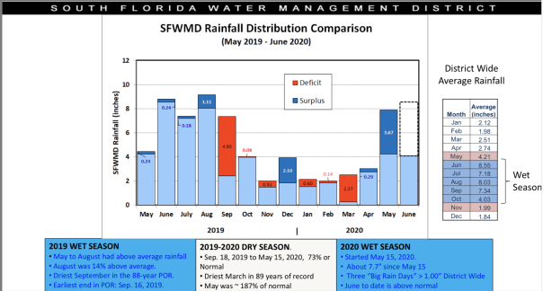
This next set of aerials was taken by my husband, Ed Lippisch, and myself the same day, 6-13-20,  a few hours later, closer to noon.  Again, it is important to note the St Lucie area recently experienced particularly heavy rains, only Broward County and parts of Miami- Dade had more. So we can learn about this, I am sharing the most recent Water Conditions Report of the SFWMD for details of all the St Lucie and all south and central Florida. See link under Rainfall Distribution Comparison slide below. 

The first group of photos from Ed and I in the Baron is of the St Lucie River and the second set is of algae blooms in Lake Okeechobee. NOTE THE ACOE IS NOT DISCHARGING INTO THE ST LUCIE AT THIS TIME.

We continue to document and thank all who are working towards projects and ways of life that better water quality in the state of Florida. We know what we need to do! 

https://apps.sfwmd.gov/webapps/publicMeetings/viewFile/25566


Sailfish Flats IRL
Exiting St Lucie Inlet looking south along Jupiter Narrows/Jupiter Island
Plume becoming visible
Looking back again into southern edge of SL Inlet

Now back at the St Lucie River and St Lucie Inlet at higher altitude
St Lucie River/Indian River Lagoon
Sailfish Point St Lucie River/Indian River Lagoon
Plume from higher perspective
Veteran’s Bridge in Palm City looking back to Stuart, note Witham Field and ocean in distance
Circling around- Hobe Sound looking north to St Lucie Inlet.
Heading west over Atlantic Ridge natural area
Approaching Lake O. FPL cooling pond visible.
S-308 at L.O. and C-44 Canal
My brother Todd Thurlow’s website shows that algae in L.O. is now showing on low resolution satellite imagery: Terra, Aqua, Suomi: http://eyeonlakeo.com/LakeO3x7days.html; http://eyeonlakeo.com
algae bloom southern rim
algae bloom like this was basically throughout southern area of lake, but denser in some areas and not so dense in others….
Ed’s palne GPS, present location south L.O.
South Lake O over southern rim
LakeO lapping towards Port Mayaca not FPL cooling pond, this area is by far the most algae ridden

Lake O
Lake O
Lake O
Lots of algae in Lake Okeechobee

MOVIE:

Now after flying west again over Lake Okeechobee algae here as well but more spread out

Another great SFWMD is the most recent Ecological Report as it discusses effects of water quantity and quality on fish and wildlife for all central and S.F.: (https://apps.sfwmd.gov/webapps/publicMeetings/viewFile/25567)

Let’s Go Fly & Check Out the Water! 3-13-20 SLR/IRL

SFWMD Weekly Environmental Conditions Report forwkly_env_conditions_ops_report_2020_03_11

My husband Ed’s aerials of the St Lucie River/Indian River Lagoon show a positive picture of area waters that in 2013, 2016, and 2018 were black and green with the repeated bruises of Lake Okeechobee’s toxic algae blooms. This is not the case last year in 2019, and so far in 2020. We must celebrate these wonderful times for our waters by enjoying them. Healthy breezes float by, fish are jumping, and a blue lavender sky beckons you…

Most important, sea grasses are recovering. ~Although dormant in winter like the plants in our yards, they bloom forth now; “spring has sprung!” Signs of life are everywhere from pink and orange, protected baby queen conch at the Sandbar, to 9 armed starfish walking about, and even the recent rare sighting of critically endangered Right Whales, ~a mother with her calf swam slowly across St Lucie Inlet. Thank God the water was clean! 

We are thankful for these times of bluer and clearer water and we will never give up the fight! Enjoy the the flight and if you can, go visit our beautiful river. 


~STARTING OUT AT C44STA/RESERVOIR, WESTERN MARTIN COUNTY, this project cleans water from the C-44 Canal before it enters the SLR

~FLYING EAST OVER THE TOWN OF SEWALL’S POINT and HUTCHINSON ISLAND provides a familiar view of the confluence of the St Luice River and Indian River Lagoon where the water bodies converge to exit at the St Lucie Inlet. Although the upper St Lucie is always ailing from years of damage, the lower St Lucie and Indian River Lagoon is very flushed by the sea. Seagrasses in the area of the Sandbar and Sailfish Flats have been dormant during winter months and are blooming out now-just like plants and flowers in our yards. It will be important to compare these photos to summer to see true recovery. 

~FLYING SOUTH ALONG ST LUCIE INLET STATE PARK, JUPITER ISLAND and then swinging north we see Hutchinson Island’s Bathtub Beach, being restored AGAIN, the 1876 House of Refuge where the mother Right Whale and calf were just a couple of weeks ago, and the nearshore reefs VISIBLE and not under black green toxic water. 

~GETTING READY FOR LANDING the plane swings back over the SLR/ILR, Sewall’s Point, towards Witham Field. 
             
~Thank you Ed! It was a beautiful flight!


Ed Lippisch -eye in the sky- SLR/IRL 2-26-20

Ed Lippisch -eye in the sky- St Luice River/Indian River Lagoon 2-26-20 3pm
Ofcouse, it’s important to document from the air during this great new era of no Lake Okeechobee discharges. In any case, the St Luice River is plagued by too many human made canals. The SFWMD basin map below reveals all.
Ed’s photos are beautiful but the color of the water is not striking as area runoff from rain is visible in grayish tones. Still, a good time to go outside and enjoy! Thank you to my husband, Ed for flying over the St Lucie River/Indian River Lagoon as I can write all day long, but “a picture speaks a thousand words!” And we will continue to work a thousand times harder to save her.
St Lucie Inlet
Sailfish Flats IRL east of Sewall’s Point
Approaching St Lucie Inlet, Sailfish Point
Sailfish Flats over Hutchinson Isl.
Atlantic & SL Inlet, Sailfish Point
Looking south to Crossroads SLR/IRL


2020 Aerial Update! St Lucie River to Kissimmee!

Pilot my husband, Dr Ed Lippisch, Dr Gary Goforth, Mark Perry Feb. 9, 2020

Between the rain and the FAA’s Presidential Temporary Flight Restrictions, it has been difficult this Florida winter to get photos of the St Lucie River/Indian River Lagoon. Luckily, yesterday, there was an opportunity to get up in the air!

Ed took Florida Oceanographic https://www.floridaocean.org Executive Director, Mark Perry, and board member, Dr Gary Goforth up for a ride. Mark wanted to check on the seagrasses and near shore reefs. Gary – the restored Kissimmee https://www.sfwmd.gov/our-work/kissimmee-river as he was very much part of this success that is still underway. As it was quite windy and I have a delicate stomach, I stayed on the ground. I didn’t  want to ruin the outing asking for an air-sick bag!

Today, I share some rare photos of the St Lucie River after being “Lake Okeechobee discharge free” for almost one year. As you can see, her seagrass beds still need a few more years to recover, but rhizomes and grasses are back in some areas, ~but not what we want- historic “all.”  The ocean waters were very turned up so it was hard to see the reefs, but the water sure was blue and for that we are beyond thankful!

Ed and I and the River Warrior Community will continue to document and fight for the continued health of our St Lucie River/Indian River Lagoon!

South of Sewall’s Point, Crossroads, photo Gary Goforth

St Lucie Inlet, near shore reefs, photo Ed Lippisch

Another view, photo Ed Lippisch

Indian River Lagoon, Sailfish Flats, photo Ed Lippisch

Sailfish Point, IRL/SLR Crossroads, photo Ed Lippisch

Restored area of the Kissimmee River, photo Gary Goforth

A Tale of Friendship and 16 Hamburgers ~Post Dorian


Ed flying Billy Vaughn, Vice-President, and Tara Baldwin, President, Operation 300. The organization is in honor of son and brother Aaron Vaughn http://op300.org

Rarely have I seen my husband with such determination, and he’s very determined all of the time…

The goal?

To get his multi-generational Bahamian friend, fishing guide, Justin Sands of Marsh Harbor, a cooler of 16 hamburgers, some buns, mustard and ketchup, and a bag of tomatoes…

Ed told me he would be flying into Treasure Cay dropping off the Vaughns, president and vice-president of Operation 300, the group in Stuart, Florida, that is doing great things for the relief effort. Ed would be greeted by Stephen Leighton who along with his brother, John, are masterminding Operation 300’s coordination. Ed had hoped to get a ride to Marsh Harbor from Treasure Cay to meet Justin, about 26 miles away. That did not happen.

“Why didn’t it happen?” I asked Ed when he got home.

“Jacqui, there’s nothing left there. The beat-up cars they have, have no gas….or very little. The car they were lucky enough to have, ran out of gas.”

So after dropping off the Vaughns and not being able to get a ride, Ed asked Steve Leighton if in the course of his work, could he please deliver the hamburgers. Ed flew back to Stuart, and then something happened that could only happen today.

With Ed now back in Florida, and Steve and Justin with very limited communication service  —Stephen in Treasure Cay, and Justin in Marsh Harbor—-the three, via text messaging, and an app called WHATSAPP, coordinated the 16 hamburger drop-off.

Stephen then sent Ed a picture of Justin and he standing amidst Marsh’s destruction- red cooler in tow. Delivery achieved! Later that evening Justin sent Ed a picture of the prepared hamburgers.

When Ed shared the photos, my eyes filled with tears…

Friendship and determination are something that Dorian cannot destroy.

Justin Sands and Stephen Leighton, Marsh Harbor Sept 18, 2019.


Other photos shared by Stephen Leighton, Operation 300, 9-18-19

Documenting the Discharges, 3-17-19

*Please note all comments become public record.

1.Ed and the Super Cub 2019. Our “eye in the sky” since 2013.

2.Tip of South Sewall’s Point looking north to Hell’s Gate. Witham Field, Stuart, west.

We continue to document the discharges…

Yesterday, 3-17-19, my husband, Ed, flew the Super-Cub over the St Lucie River/Indian River Lagoon ~ twenty-one days after the ACOE started discharging from Lake Okeechobee on February 24, 2019.

When Ed arrived home, I asked, “So how was it?”

“Brown,” he replied.

“Like dark coffee brown, or kind of like that weird mixed greenish-brown?”

He looked at me, and smiled. “Jacqui, it was brown.”

“OK, I said, I’ll take a look at your photos.”

So here are the photos from Ed’s flight from Witham Field in Stuart, over Sewall’s Point and Hutchinson Island, then out west  to S-80 to see the “Seven Gates of Hell” where you can see the one gate discharging now at an average of 250 cubic feet per second, down from an average of 500 cubic feet per second. As you can see from the SFWMD chart below, there has been other runoff locations as well, but the majority is from Lake Okeechobee.

ACOE Press Release: 3-14-19, ACOE, showing decision to go to 250 cfs to SLR/IRL. ACOE says they are “pulse releasing,” however, these are not the “pulse releases” we are familiar with during prior discharge destruction events, as the number never goes to 0, it just goes up and down. https://www.saj.usace.army.mil/Media/News-Releases/Article/1784910/corps-to-continue-lake-o-release-plan-with-minor-adjustments/

Thank you to my husband Ed, for showing us that right now, the river is brown.

ACOE, Periodic Scientists Call, 3-12-19, http://w3.saj.usace.army.mil/h2o/reports.htm


3. Approaching the SL Inlet, algae covered remaining seagrass beds

4.Sandbar formation inside of SL Inlet

5.Blurry but shows boats at the Sandbar and that weird green brown color

6.Sailfish Point and SL Inlet algae covered remaining seagrass beds

7. Ernie Lyons Bridge, IRL with SL inlet and Hutchinson Island in distance

8. S-80 along C-44 Canal or the Seven Gate of Hell, boats going through locks, “250” cubic feet per second coming though

The following phots are of Caulkins Water Farm, a former orange grove that died due to citrus greening that now holds water from the C-44 Canal. This is a wonderful thing! As local ag-man Mr. Hadad, told me once, “Jacqui we spent 100 years taking the water off the land, and we’ll spend the next 100 years putting it back on.” The later photos are of S-80 again with view of C-44 canal leading west to Lake O.(https://www.facebook.com/CaulkinsWaterFarm/)

9.

10.

11.

12.

13.

14.

15.

16.

17.

18.

19.

20.

21.

22.

23.

24.

The following photos are when Ed headed back to Witham Field going once again over the St Lucie Inlet over the Atlantic Ocean. You can see the water looks blue north of Sailfish Point north of the inlet with nearshore reefs visible. Plume is also visible south of St Lucie Inlet. Also in photos is the winding Jupiter Narrows and St Lucie River in the area of Stuart and Rio. You can see Langford Landing with scraped orange soil and docks built into river still under construction since 2015.

Thank you to my husband Ed, our eye in the sky!

25.

26.

27.

28.

29.

30.

31.

32.

33.

34.

35.

36.

37.

38.

39.

40.

41.

42.

43.

Temporary Flight Restriction, no Documenting the Discharges this past weekend, SLR/IRL

*Please note comments become public record.

Temporary Flight Restrictions were in place this weekend as President Trump and the First Lady were visiting their home, Mar-a-Lago, in Palm Beach. The restrictions go right up to the edge of Stuart, thus it was not possible to fly into the Crossroads or St Lucie Inlet to continue documenting the discharges that began on February 23, 2019.

Instead, today, I am posting  a link to an article by Tyler Treadway of TCPalm entitled:

If Army Corps stops Lake Okeechobee discharges soon, St. Lucie River Suffers Little Harm. It states:

“Two weeks of Lake Okeechobee discharges haven’t caused much damage to the St. Lucie River estuary, but an environmental expert says extending the releases much longer could be devastating.

The Army Corps of Engineers, which started discharging lake water to the river estuary Feb. 25 at an average daily rate of about 323 million gallons, plans for the releases to continue at least until March 16.

They’d better not last much longer, said Mark Perry, executive director of the Florida Oceanographic Society in Stuart.”

Full article: https://www.tcpalm.com/story/news/local/indian-river-lagoon/health/2019/03/08/lake-okeechobee-discharges/3058538002/

From what I understand the releases are scheduled for 21 days which would put them through around March 15, 2019.

Ed did fly to Zephyr Hills near Tampa, so I asked him to take photos of that trip. Below you can see Moore Haven, S-308 Port Mayaca, Lake Okeechobee, and other aerials of interest. Ed said he saw no cyanobacteria or blue-green algae in Lake Okeechobee.


Link to TFR: https://contentsharing.net/actions/email_web_version.cfm?ep=vqM2fy2Ox3oo9a147CjVbkrn0IwxwCFcFsGjQGPffFSuxLqprS7UmNebRP1WKNSpmESJaQbSeNkWzNzkVbOhe990ltCQy62JQYPbMjyXjRjnBFTvJig3MX3kqpGJ25BT

S-308 at Port Mayaca, going to C-44 and SLR.

Near Moore Haven where canal goes to Calooshatchee, near S-79.

Somewhere on the way to Tampa region.

Over Lake O.

Looks like part or Restored Kissimmee River above Lake O, with canal.

Flood plain

Lake O again

C-44 canal, FPL pond, heading to Stuart. S-308 just being passed at Port Mayaca, Lake O.


Near Tampa, Zephyr Hills area – area one sees what looks like phosphate ponds, mines this is a big issue for water quality for rivers like the Peace and others in Central Florida.

Ed and I will try for an update of the discharges next week!

Looking Back, St Lucie River ~Rain and Algae 2018

Even though the water in yesterday’s photo looked gorgeous, lest we forget, here are some images of the St Lucie River/Indian River Lagoon area during a rainy and cyanobacteria ridden 2018.

Ed and I didn’t start taking pictures until were motivated…

In March 2018 there was a tremendous rain event. (https://www.sfwmd.gov/our-work/flood-control/managing-high-water)
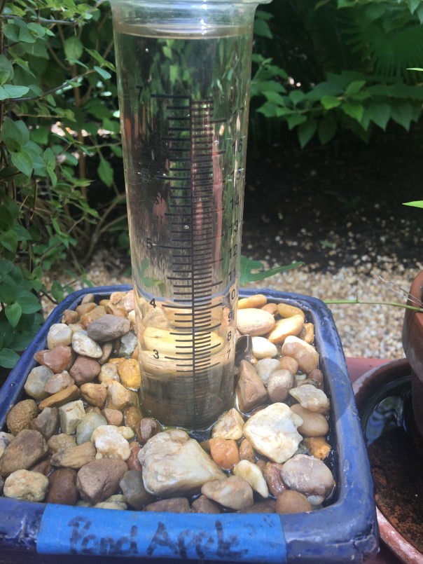
My homemade rain gauge showed over 27 inches in just a few days along the coast!

You’ll see that after the rain event, the St Lucie River/Indian River Lagoon looks terrible even with out Lake Okeechobee discharges. This is caused by directed water runoff from C-23, C-24, C-25, C-44 and “local” coastal runoff.  Naturally, the river never took all this water. Humans made it this way, and we must fix it.

SFWMD canal and basin map.

Soon after the torrential rain, the Army Corp of Engineers made things even worse and started dumping from Lake Okeechobee through the C-44 Canal into the St Lucie River by opening up the gates at S-308 and S-80.

My husband, Ed,  first flew over Lake O on June 1st,  just by chance. At this time, he spotted algae on the lake and took a photo.  Ironically, the next day, the Army Corp started dumping from Lake Okeechobee on June 2nd!

The algae or cyanobacteria (http://www.ucmp.berkeley.edu/bacteria/cyanointro.html)
that was festering in the Lake began to show up almost immediately thereafter in the St Lucie River that has also become  a “nutrient porridge.”

The rest unfortunately is history. 2018  was bad, but in my opinion not as awful as 2016 when the ocean was totally green: https://jacquithurlowlippisch.com/tag/bathtub-beach-algae/

After another long, hot summer, the Army Corp finally stopped discharging in the fall~October 5th… Take a look at the photos and remember to enjoy the blue water when it is here, but NEVER FORGET! Only though looking back, will we have the determination to change the future.

Major rain event in March 2018.  Rain filled this vile up many times!

SLR IRL following major rain event in March 2018. This is runoff from C-23, C-24, C-25, C-44,  and “locally” from developed areas along the river and uplands made to drain into river. JTL

Following rain event in March 2018. A brown Atlantic.

Following rain event in March 2018, the SLR/IRL ~Scott Kuhns

Following rain event in March 2018 Sailfish Flats between Sewall’s and Sailfish Points ~Scott Kuhns

June 5th. A very dark plume moves south along Jupiter Island, just days after ACOE begins dumping so this is a combination of all pollution/runoff  waters…

LAKE OKEECHBEE DISCHARGES ADDED

Ed in the Cub after plume photo

Algae as photographed/spotted by Ed in Lake O on June 1st 2018.

City of Stuart, June 9 2018.

Rio near Central Marine, week of June 12, 2018

Photographing a manatee in the algae along seawall by Mary Radabaugh

Mary Radabaugh manages Central Marine with her husband. JTL

Mary found a dead baby manatee floating in the putrid water shortly after LO discharges.  MR

LAKE O: Week of June 16th, June 25th, and July 22nd. Cyanobacteria (blue green algae) blooms and then subsides. ~All the while, this water is dumped into the St Lucie River by the Federal Govt.; the water quality is terrible and this the responsibility not of the Feds but of the State of Florida.

Algae is now very visible in Lake O, June 16, 2018 JTL

June 25, 2018 Lake O, near S-308, Port Mayaca.  JTL

C-44 canal leading to SLR from Lake O.

C-44 canal leading from LO to SLR.

Satellite view LO bloom on June 24, 2018. ~At its height.

By July 22, 2018 the bloom in the LO is lessening, JTL

August 29, algae would come and go, throughout the SLR. Here near Overlook Drive JTL

September 4, algae still “coming and going” ~2018 Snug Harbor, Stuart.  Photo by my uncle, Dale Hudson

October 5, the ACOE stops dumping from Lake O. The blooms stop almost right away but the damage remains….

December 8, 2018 the river looks “normal” again near Sewall’s Point but it is not. JTL

Blue Water on Christmas Day, 2018

What should be normal, was a gift on Christmas Day, blue water in the St Lucie River/Indian River Lagoon. The peninsula of Sewall’s Point shone like the gem it is surrounded by aquamarine on both sides: the St Lucie River on its west, and the Indian River Lagoon on its east…

Feeling like the Bahamas, rather than the toxic-sludge we had to endure ~coming mostly from Lake Okeechobee this past summer, 2018, and yes, remember 2016, and 2013….the destruction must stop!

As 2019 edges into the picture, we will once again have to give everything we have to fight for clean water and encourage our state and federal government to support legislation “sending the water south.”

Seeing these beautiful blue waters once again is certainly encouraging. Now to keep the Army Corp and South Florida Water Management District at bay long enough, as projects proceed, and allow our precious seagrass beds to return so baby fish can once again hide, swim, and grow to maturity in these waters; once christened the “most bio-diverse in North America.”

Thank you to my dear husband, Ed, for these photos all taken 12-25-18. And from both of us, “Merry Christmas!”

Sewall’s Point lies between the St Lucie River and Indian River Lagoon

Sailfish Flats between Sewall’s and Sailfish Point. Seagrass remains bleak after years of discharges from Lake O, and other area canals

St Lucie Inlet opening to the Atlantic Ocean between Sailfish Point and the southern end of St Lucie Inlet State Park on Jupiter Island

Another angle of St Lucie Inlet area

Remnants of once lush sea grass beds off Sewall’s Point

Another angle: Evan’s Crary and Ernest Lyons Bridges on far right

A great shot of the now pathetic seagrass beds. This area was once considered “the most bio-diverse in North America,” with approximately 700 acres of healthy seagrasses in this area between Sewall’s and Sailfish Points

Photo below as a comparison ___________________________________________________________________________

NEVER FORGET! Town of Sewall’s Point, Martin County Florida, 9-2013 surrounded by polluted waters released from Lake Okeechobee. Even the ocean brown! Similar years were 2016 and 2018 both with cyanobacteria blooms along shorelines. This awful sediment, and nutrient filled water is dumped on us by our federal and state government and is a health hazard.

To Close the Beach, or Not to Close the Beach, This is not the Question, SLR/IRL

“Yes. No. No. Yes. Oh wait, sure OK…Sorry, No!”

Such has been the direction from Martin County Government of whether the public is allowed to swim at area beaches.

Let’s review recent days….

8-21-18: Bathtub Beach reported as closed

8-24-18 Bathtub Beach reported as not closed

8-25-18 Bathtub Beach, Stuart Beach, and Jensen Beach reported as closed

These changes are very difficult to keep up with!

Although the 2018 pulse release schedule from the ACOE is certainly a good thing, and a positive effort, one has to wonder if that is part of the reason for the recent back and forth scenario reporting. In 2016 with no pulse releases the algae was everywhere and plastered the beaches with no breaks.

screenshot 2.png

In any case, it has been crazy around here, and unfortunately, the only safe way to deal with things, is to take the “may” out of the permanent signs and not to swim in the water anywhere.

When I visited lifeguards at Bathtub Beach on August 24, the word was if one got on a surfboard and paddled out 50 yards, cyanobacteria was floating in clumps in the sea water watered down by fresh water discharges from Lake Okeechobee since June 1st.

~On and off that is…

To try to get a handle on things, Ed and I took up the SuperCub for the first time on Saturday,  the day all beaches were closed, and boy was that a good thing they were closed because blue-green algae was flowing down the St Lucie River in long arched lines. Right in the middle of the river!  And this was a day the ACOE had stopped discharging from the Lake…As Ed and I were flying around up there in heavy winds,  I was trying to figure out the timing of the algae’s 35 or so mile journey from Lake O and how the pulse releases would affect it.

When Ed and I photographed, the algae was just west of the beautiful peninsula of Sewall’s Point and out in the main St Lucie River.

God what have we done?  My home town?

To close the beach or not to close the beach, that is not the question. The question is how did the state of Florida let the most bio-diverse estuary in North America go straight to hell.

The wild thing about flying in the SuperCub is that I can communicate via text and Facebook. As Ed and I were taking photos from the sky of what was heading to Martin County beaches, reports were coming in of the algae blowing up from the ground from my friend Mary Radabaugh at Central Marine, located in the same area Ed and I were flying. Go to Toxic#18 Facebook for more reports.

Martin County Beach Hotline:http://martin.floridahealth.gov/programs-and-services/environmental-health/beach-and-river-sampling/results/index.html

John Moran’s “Florida’s Summer of Slime: Stuart and Lake Okeechobee”

It’s an honor to present:

“Florida’s Summer of Slime: Stuart and Lake Okeechobee,” photo essay by John Moran, August 2018

I reported last month on the plight of the Caloosahatchee River and its befouled waters flowing from Lake Okeechobee; delivering slime to waterfront neighborhoods in Fort Myers and Cape Coral along the way to the Gulf Islands of Southwest Florida.

Next up on our Summer of Slime photo tour is a visit to Stuart and Lake O…Stuart and environs is a glistening jewel born of water. It may well top the list of Florida cities in shoreline per capita. There’s simply water everywhere. Two forks of the St. Lucie River, the Indian River Lagoon, canals and peninsulas and islands, and the Atlantic Ocean beyond. Stuart is pictured above; below is neighboring Hutchinson Island.

But it wasn’t Stuart’s reputation for abundant clean water that drew me south from Gainesville with my cameras. In effect, I’ve become a traveling crime scene photographer—and slime is the crime. A devastating outbreak of toxic algae has once again hit the St. Lucie River and the Treasure Coast, fueled by the polluted waters of Lake Okeechobee and the Kissimmee River basin to the north. Damaging headlines trumpet the story to the nation and the world and Governor Scott has declared a state of emergency. It’s déjà vu all over again.

My hosts in Stuart were water blogger Jacqui Thurlow-Lippisch and her husband, Ed Lippisch.

Ed took me up for a photo flight in his Piper Cub so I could get the big picture.

Seen from a small plane at 500 feet, Florida is a beautiful place.

Here’s Lake Okeechobee and the western terminus of the St. Lucie C-44 Canal. Administered by the U.S. Army Corps of Engineers, the Port Mayaca Lock and Dam has the capacity to discharge 14,800 cubic feet of water per second downstream to Stuart and the St. Lucie River Estuary, 26 miles away.

Sugar industry representatives say the water coming out of Lake Okeechobee is not the problem and that the algae outbreak in Stuart is primarily caused by Stuart’s own septic tanks and urban stormwater. This claim is contradicted by the extensive algae mats seen along the C-44 Canal between the Port Mayaca and St. Lucie Locks, well upstream from Stuart.

Lake Okeechobee historically drained south to Florida Bay, not east and west to the Atlantic and Gulf. The C-44 canal was built in 1916 to divert floodwaters to the coast.

A view of the St. Lucie Lock and Dam, several miles southwest of Stuart. On the day of my photo flight in late July, the dam gates were closed, visibly holding back algae from flowing downstream. Look closely and you can see what some people call The Seven Gates of Hell.

The St. Lucie Lock and Dam are an integral part of South Florida’s complex web of water management structures, born of an age when the Everglades was reviled as a watery wasteland and America was driven to drain it.

Below the St. Lucie Lock and Dam, in Palm City and Stuart, you can still find waterfront homes untouched by the algae bloom. But that’s no consolation for the thousands of Martin County residents whose lives are in upheaval once again this summer. The familiar pattern of algae outbreaks is fueled by fertilizer, manure and urban sources of nutrient pollution, including septic tanks.

All of this is compounded by denial and neglect by elected officials and agencies to whom we entrust the important work of environmental protection and public health.

Jacqui Thurlow-Lippisch took me on a driving tour of the C-44 Canal from Stuart to enormous Lake O, which is more like a stormwater treatment pond than a biologically healthy lake. “There are toxic algae blooms across the globe, but only one place where the government dumps it on you: Florida,” she says.

It’s not just the algae from Lake Okeechobee causing headaches along Florida’s east coast; the sheer volume of freshwater discharges is an environmental pollutant that overwhelms the estuary.

The Lake O gunk visible in the satellite view, above, is shown in the detail photo below.

Fishermen are still drawn to Port Mayaca. On the day we visited, I counted nine.

Dinner in hand (speckled perch), Felix Gui, Jr. has been fishing Lake O for 30 years. “The algae doesn’t affect the fish,” he says. “They eat the same, algae or no algae, and I haven’t gotten sick.” Experts have warned against eating fish exposed to the algae.

A Martin County Health Department sign at Port Mayaca warns against contact with the water but I saw no messaging about whether fish caught in these waters is safe to eat.

Enroute home to Stuart, Jacqui and I stopped at deserted Timer Powers Park on the St. Lucie Canal in Indiantown.

At the St. Lucie Lock, a surreal scene of impaired water, above, and a vortex of slime, below, waiting to be flushed downstream.

A pair of jet-skiers signaled for the lock to be opened, and another pulse of algae-laden water is released towards Stuart and the coast.

Wouldn’t want to anyway, thanks.

Further downstream, the algae spreads…

Nearing the coast, Rio Nature Park and the neighboring Central Marine in Stuart are slimed again. This was the epicenter of the infamous Treasure Coast algae outbreak of 2016.

Reporter Tyler Treadway of TCPalm gathered a sample of the polluted water from a canal behind the offices of Florida Sportsman magazine in Stuart.

Staff complaints of headaches, nausea and dizziness prompted Florida Sportsman publisher Blair Wickstrom to temporarily close the office in late July. “It smells like death,” he said.

The Shepard Park boat ramp parking lot in Stuart was nearly empty on the day we visited.

A man on a mission, Mike Knepper, above and below, posts videos on his Youtube channel documenting the degradation of natural Florida.

“It’s totally unacceptable to me what we’re doing to this planet because we’re very rapidly destroying it,” Knepper says. “My children and grandchildren will be paying the price for all the bad decisions we’re making today. I want to be able to look them in the face and say, ‘I tried to make a difference.’”

Dead-end canals along the St. Lucie River with their limited water exchange have been hardest hit by the toxic blue-green algae, which scientists refer to as cyanobacteria.

A growing body of medical research links exposure to cyanobacteria with neurodegenerative diseases including Parkinson’s, ALS and Alzheimer’s. Google it.

Meanwhile, we’re getting conflicting messages from officialdom. Martin County has erected signs warning against contact with the water but the Florida Dept. of Health website, under the heading How to Keep Your Family Safe While Enjoying Florida’s Water Ways, has this to say: “Cyanobacteria/ blue-green algae…are naturally occurring in Florida’s environment and are also found all over the world. They are part of a healthy ecosystem and help support a wide variety of aquatic life.” (http://www.floridahealth.gov/environmental-health/aquatic-toxins/cyanobacteria.html) In other words, Lighten up, Florida. This is just nature being natural.

An open question remains: What will become of the value of the Florida brand when the world fully sees what we have done to our waters?

Even in disaster, strange beauty emerges.

Greg Fedele has lived in his water-front home since 1991. He grieves for his loss. “I have three kids who can’t enjoy the waterways of Martin County like I did growing up.”

The sign at Ocean Blue Yacht Sales in Stuart echoes a wide swath of community sentiment. Asked to describe in a word how the algae outbreak has impacted his business, president Bryan Boyd replied, “Horrible. The last three years, our bay boat sales have been a third of what they used to be.”

A roadside sign seen in Stuart in late July. If you’re wondering what you can do about the ongoing crisis of Florida waters, we are called to consider our own water footprint, learn about the issues and get involved. And never forget that elections have consequences. Vote for Clean Water. (https://www.bullsugar.org/#)

What we have here in Florida is not just a crisis of water, we have a crisis of democracy and civic engagement.

From the beleaguered springs of North Florida to the sickened rivers and coasts of South Florida, we must understand that no savior is waiting on the horizon who will fix this thing for us.

It took a group effort to create this mess and we need all hands on deck if are to reclaim our waters. Florida needs environmental patriots willing to face down politicians funded by wealthy interests who think nothing of sacrificing our public waters on the altar of their private profits.

We don’t have the luxury of time to get this right. We are losing our waters now. This is our moment. It’s time to set aside our differences and focus on what is at stake, for this is nothing less than a battle for the soul of Florida.

The pictures don’t lie. We the people of Florida bear witness today to nothing less than a crime against nature, and a crime against the children who shall inherit our natural legacy.

A long time ago, Florida political leaders—Republicans and Democrats in common cause—understood there can be no healthy economy without a healthy environment. They wisely enacted laws and regulatory safeguards accordingly.

But that was then and this is now. It’s time to end the popular fiction in Florida that we can plunder and pollute our way to prosperity.

Gov. Reubin Askew said it best when he declared in 1971, “Ecological destruction is nothing less than economic suicide.”

In this, our Summer of Slime, can I get an amen?

by John Moran
August 2018

web: http://johnmoranphoto.com
email: JohnMoranPhoto@gmail.com
cell: 352.514.7670

Feel free to forward or post this photo essay as you wish; attribution is appreciated. Please share this with elected officials and ask them: what’s their plan to clean up our waters?

“Cockpit With a View,” Explosive Algae Bloom in Lake O, SRL/IRL

The pilots, our “Eyes in the Sky”- like satellites – are the key to “seeing” the extent of the algae problem in Lake Okeechobee, and provide a clear cockpit-view showing how algae gets into our St Lucie River.

I thank all of the pilots, east coast, west coast who have recently shared their cockpit-views.

Today’s photos are from pilot Steve Schimming who sat right seat, at about 1500 feet,  during Ed’s fly over of Lake O on Saturday when the two men were on their way back from Venice mid morning where they had gone to meet other pilot friends.

This enormous bloom, 102 square miles approximately, was reported, by me, to the Florida Department of Environmental Protection the same day. Hopefully, they are testing it in multiple locations. Although the ACOE holds the power to decide when to discharge from Lake O, it is DEP in coordination with the SFWMD, and the Water Quality Dept. (Best Management Practices) of the Dept Agriculture, that is in charge/responsible for water quality for Florida.

To report an algae bloom: https://floridadep.gov/dear/algal-bloom

Thank you Steve for sharing what you saw.

Almost like being there…

Steve Schimming, 6-16-18, Lake Okeechobee

___________________________________________________________________________

Ed Lippisch photo same day, same flight:

Ed Lippisch 6-16-18. Lake O algae bloom

For more photos go to this link: https://jacquithurlowlippisch.com/2018/06/16/real-time-eye-in-the-sky-of-102-sq-mi-lake-o-algae-bloom-6-16-18/

Sentinel Satellite image 6-15-18

Approximate size of bloom as seen from Sentinel satellite. See link to most recent satellite images made public and easy to find, by Todd Thurlow:http://www.thurlowpa.com/LakeOImagery/

#toxic2018

Real-Time Eye in the Sky of 102 sq.mi. Lake O Algae Bloom, 6-16-18

Things are happening almost in real-time today. My brother, Todd, sent me the L7 and Sentinel satellite images from yesterday revealing an approximate 102 square mile bloom in Lake Okeechobee.

I, in turn, wrote a blog post and sent the image to my husband, Ed Lippisch, who had flown across to west coast of Florida this morning.

Not too long after sending Ed that image, I look at my phone and it says “shared” photos from Ed, so I start looking at them. They are of the bloom in L.O. – over the broad area where the satellites had detected algae.

The phone rings, it’s Ed, he says” I just landed in Stuart.” I reply, “Great photos. Horrible. Thanks.”

He says: “Jacqui it was unbelievable. Very large bloom, it ran above Port Mayaca to about the southern shore of the lake and westerly. Very much like the satellite image you sent me, but even further north…”

So here are Ed’s unedited photos taken and then sent to me at 1:14pm, 6-16-18. Today.

#toxic2018

Documenting the Discharges, June 2018, SLR/IRL

When the St Lucie River/Indian River Lagoon start to deteriorate due to discharges, things start going downhill fast. And when my husband Ed and I start taking and sharing aerial photos, my world becomes a bit chaotic.

Sometimes there are days of hundreds of photos to look through, and knowing the importance of getting them out immediately, choices have to be made. Facebook is a better medium than my blog for real-time info as it takes less time, but my blog is better for historic documentation as it is “permanent.”

So today I am sharing more of Ed’s photos from 6-5-18, and some you may have already seen. Mind you, after heavy rains, stormwater has been pouring in from many canals but, always, like clockwork, after the ACOE starts discharging from Lake Okeechobee, the river looks not just cloudy-coffee brown, but contaminated.

The ACOE started discharging from Lake Okeechobee on  6-1-18, and as most of you know, now, there are not only algae blooms spotted in the lake, as Ed accidentally found on 6-2-18, and others also documented, but also in the St Lucie River. More than likely, there will be more and more  algae bloom popping up as the Lake O water makes its way down the estuary, over the tip of Sewall’s Point, towards the St Lucie Inlet. Algae floating down the river is disgusting enough, but toxicity is the real question…

Ed and I will take and share more aerials  in the future, to document the algae blooms should they explode, but until then, here are some photographs from 6-5-18 that I had not yet archived on my blog. Sadly enough, although there is no algae in these pictures, I cannot say they will make you feel any better.

Never take the pressure off politicians to build the EAA Reservoir and get it to where it needs to be to clean and filter this water to send south as Nature intended.  Government knowingly contaminating its citizens is not an option. Health, Safety and Welfare is a responsibility.

Photos taken 6-5-18 showing SLR/ILR near Sewall’s Point; Jupiter Narrows; Atlantic Ocean/beach over nearshore reefs along Jupiter Island just south of St Lucie Inlet; out in ocean near Peck’s Lake; Sailfish Point/Sailfish Flats area; and Bird Island, a Critical Wildlife Area, for many threatened and endangered birds.

SLR on west /IRL on east – looking towards Sewall’s Point

Jupiter Narrows near St Lucie Inlet

A Coffee Ocean along Jupiter Island just south of St Lucie Inlet

Discharges in waves looking east to Peck’s Lake

Discharges going over near shore “protected” reefs

Discharge plume

Plume out about 2 miles in Atlantic/documented at 5 over days by fisher people

Similar photos give felling of flying over

Reefs with plume coming on

Selfish Point and Sailfish Flats area one the “most biologically diverse in North America.” Seagrass is gone due to receptive discharges episodes

Circling home- close up souther tip of Sewall’s Point

Again circling ove Sailfish Flats on way back to Witham Field.

Bird Island just off of southeast Sewall’s Point is home to hundreds/thousands of birds. Many threatened and endangered species raise their young on this island that was designated a CWA or Critical Wildlife Area by FWC in 2014. At the time it was the first to be designated in 20 years.

The Algae Comes From the Lake, Documenting the Discharges, 2018, SLR/IRL

Since my husband, Ed, accidentally spotted an algae bloom in Lake Okeechobee, while running new engines on the Baron, I have posted many photos on Facebook and the word is out.

Nonetheless, for purposes of documentation, I am going to post some of the photos again on my blog for historical purposes and for those who do not use Facebook.

~Ed noticed the “lines of algae” in the lake on June 2, two miles or so northwest of Port Mayaca, the day after the ACOE started discharging from Lake O into the St Lucie River. Absolute chance, fate, or a tip from above, however you decide to look at it.

Since this time others have documented on the ground and DEP should be testing for toxicity.

So, after seeing the bloom on Friday, Ed went back the following day on Saturday in windy conditions so I stayed home–in the yellow plane, the Cub, getting more pictures of bloom, looking about the same but more dispersed from rain perhaps. These photos at lower altitude also include drainage structures around the lake, as well as the destruction of the St Lucie River/Indian River Lagoon at Sewall’s Point and the St Lucie Inlet.

Photos will continue to be taken as we once again, document the discharges, and once again have seen first-hand, like we did in 2016, without the warning of our government, that the algae that contaminates the St Lucie River starts in Lake Okeechobee.

Saturday, June 2, 2018

Sunday, June 3, 2018

Don’t be Fooled by Beauty; Our Barren River… SLR/IRL

My husband, Ed, took these photos of the Indian River Lagoon at the St Lucie Inlet on 2-28-18, just a few days ago. They are certainly beautiful enough to sell real estate…The turquoise water is so pretty one could easily overlook the sand desert below the surface waters.

Enjoy the blue water, but know that especially since 2013, our seagrass beds have been decimated by black sediment filled waters and toxic discharges from Lake Okeechobee. Seagrasses are the nursery for all sea life, especially the baby fish. These beds need time to reestablish if they ever will.

True beauty has something to offer, not just “surface water.” Keep your eye on the lake and fight against any coming releases this summer so we can get life back in our dear dead river.
 

Lake O level, ACOE: http://w3.saj.usace.army.mil/h2o/currentLL.shtml

The Importance of Seagrasses, FWC: http://myfwc.com/research/habitat/seagrasses/information/importance/

Documenting the Discharges 12-27-17

I guess one could say the St Lucie River is getting a new year’s present in that yesterday was the last scheduled release from Lake Okeechobee by the Army Corp of Engineers. The entire situation has a similar theme to an abusive relationship where the beaten thanks their oppressor for finally halting…

Therefore, I will not say “thank you.”

http://www.saj.usace.army.mil/Media/News-Releases/Article/1402349/corps-transitions-to-lower-flows-from-lake-okeechobee/

http://www.saj.usace.army.mil/Media/News-Releases/Article/1402349/corps-transitions-to-lower-flows-from-lake-okeechobee/

Due to Temporary Flight Restrictions (TFR) because of the President’s visit to Palm Beach, it was not possible to fly south along Jupiter Island from Witham Field in Stuart, however, when the wind and runway changed my husband, Ed, was able to get a few aerials at the Crossroads of the St Lucie River and Indian River Lagoon around Sewall’s Point. No seagrass, but the water already looks better.

After being decimated in 2013; part of 2015; toxic in 2016; and experiencing a no-holds-barred discharge rate since September 20, 2017, post Irma; we will continue to fight for the EAA Reservoir’s success and a better 2018 for our St Lucie River.

We shall never, never, never, give up!

Please see links to my brother Todd Thurlow’s website for St Lucie Canal Real Time Flows S-80 Cumulative 2017 and Latest Lake O Satellite Imagery

http://www.thurlowpa.com/LakeOLiveData/2017/

http://www.thurlowpa.com/LakeOImagery/LakeO3x7days.html

http://tfr.faa.gov/tfr_map_ims/html/index.html http://tfr.faa.gov/tfr_map_ims/html/ns/scale5/tile_14_15.html http://tfr.faa.gov/tfr_map_ims/html/ns/scale6/tile_28_29.html

All photos of SLR/IRL by Ed Lippisch 12-27-17

ACOE data is for previous weeks. Obviously the St Lucie gets enough redirected and area runoff without Lake O. ACOE 12-21-17

Documenting the Discharges 11-19-17, SLR/IRL

Last Thursday on November 16, the ACOE reported they will reduce the amount of water they are releasing from Lake Okeechobee. The Corp had been releasing at a high rate, on and off, since September 20th. New targets are 2800 cfs east and 6500 cfs west.

Photos below were taken yesterday, 11-19-17 by my husband, Ed Lippisch. We will continue to document the discharges from Lake O, and area canals.

As Thanksgiving approaches, we are thankful the discharges are lessened and that the SFWMD and the public are working hard to plan the EAA Reservoir Senator Negron fought for… We the people of Martin County, will not be satisfied until these discharge stop. The river has its hands full with unfiltered discharges draining agriculture and developed lands from C-23, C-24, C-25 and C-44. All must be addressed.

“And where the river goes, every living creature that swarms will live, and there will be very many fish. For this water goes there that the waters of the sea may become fresh; so everything will live where the river goes…” Ezekiel 

St Lucie Inlet, Sailfish Point R, Jupiter Island L, and Sewall’s Point and mainland Stuart in distance.

Sewall’s Point

Manatee Pocket

Hell’ s Gate Sewall’s Point to right

C-23 main SLR

Confluence of SLR/IRL at Sewall’s Point’s southern tip

Sewall’s Point

IRL looking towards Sewall’s Point and Stuart. Incoming tide pushes plume waters north into IRL

somewhere looking down…

SFWMD canal and basin map. C-44 canal is the canal most southerly in the image and was connected to Lake O in 1923. C-23, C-24 and C-25 were built later in the 50s as part of the Central and South Florida Project that over-drianed South Florida causing many of the water problems we live with today.

Atlantic ocean off Jupiter Island, plume water moving south over nearshore reefs

IRL near Sailfish Flats where seagrass forests used to flourish housing many fish…

Hutchinson Island looking to IRL

Roosevelt Bridge SLR

C-23 SLR

Documenting the Discharges, 10-29-17, SLR/IRL

These aerial photos over the St Lucie Inlet were taken by my husband, Ed Lippisch, Sunday, October 29, 2017, at 1:45pm. 

The number one issue here is the polluted waters of Lake Okeechobee being forced into the SLR/IRL because they are blocked by the Everglades Agricultural Area from going south. 

The ACOE has been discharging Lake O waters into the St Lucie since mid-September. These over-nutrified and sediment filled waters continue to destroy our economy and ecology on top of all the channelized agricultural and development waters of C-23, C-24 and C-25. Stormwater from our yards and streets also adds to this filthy cocktail. 

Near shore reefs, sea grasses, oysters, fish? A human being? Better not have a cut on your hand…Not even a crab has an easy time living in this.

We move forward pushing the SFWMD and ACOE for the EAA Reservoir with these sad photos and the fact that our waters are putrid at the most beautiful time of year as motivation. We will prevail. One foot in front of the other. 

Save the St Lucie! Save the Indian River Lagoon!

Links to ACOE website: See S-80 & S-308, others intesting too. Northern waters should also be cleaned! http://w3.saj.usace.army.mil/h2o/reports.htm

A Chocolate Ocean; A Black River, A Disgrace, SLR/IRL

Flight over SLR/IRL to view canal C-23, C-24, C-25 and especially present high releases from Lake Okeechobee through C-44 Canal. JTL/EL 10-14-17

Yesterday, I asked Ed to take me up in the plane, once again to document the discharges. In the wake of much rain and an active hurricane season, the St Lucie River/Indian River Lagoon continues to sacrifice its economy, health, and ecosystem for the EAA and South Florida drainage. A standard operating procedure that is outdated and dangerous.

The discharges from Lake O. have been on and off since Hurricane Irma hit on September 20th. Presently they are “on,” and it shows. Right now our river and ocean shores near the inlet should be at available to boaters, fisher-people, and youth, in”full-turquoise-glory.” Instead, the estuary, beaches, and near offshore is a ghost-town along a chocolate ocean and a black river. The edge of the plume can hardly be distinguished as all is dark, sediment filled waters. A disgrace.

ACOE 10-15-17

10-15-17 Lake O is high. This is a threat to those who live south and around the lake.

South Florida’s southern Everglades, 1850 & today. The water that used to flow south now is sent to the ocean and Gulf of Mexico through canals C-44 (SLR) and C-43.(Cal.) (Map courtesy of SFWMD.)

Image showing drainage of S. Florida through St Lucie and Caloosahatchee rivers. These rivers, that God did not connect to Lake Okeechobee, have been channelized by humans to dump Lake O. This drainage system put in place  in the 1920s does not serve Florida today. Not economically, health wise, or environmentally. We must continue to push to replumb the system the best we can.  (Public image.)

ACOE, Lake O: http://w3.saj.usace.army.mil/h2o/currentLL.shtml
S-308 and S-80 connected to both LO and C-44: http://w3.saj.usace.army.mil/h2o/reports.htm
C-23,(S97) C-24,(S49) C-25 (S99): http://my.sfwmd.gov/portal/pls/portal/realtime.pkg_rr.proc_rr?p_op=FORT_PIERCE

I told Ed it’s best not to smile for this photo. We look forward to seeing the model and timeline from the SFWMD and ACOE for Senator Negron’s reservoir, and the beginning of turning this century old nightmare.


SFWMD basin map for SLR showing canal discharge structures.


Most Recent Disturbing Photos of Discharges from Lake Okeechobee and Area Canal, SLR/IRL

Today is October 7th, 2017 and I am sharing photos taken October 6th, 2017 in the area of the St Lucie Inlet displaying the recent discharges from Lake Okeechobee and area canals. The plume was measured four miles out, this is very far, and can be seen both north and south of the inlet. The edges are churned up and  blurred, and there are many layers fanning out.

I share to document. I share in hope of eventual change, and I share to inspire the so many people who are causing change, change,  that one day we will see in a better water future.

Thank you to my husband Ed for piloting, and to passenger, and photographer, Matt Coppeletta.

Sincerely,

Jacqui

All photos taken of the St Lucie Inlet area on 10-6-17 by Ed Lippisch and Matt Coppeletta. Discoloration of water is caused primarily by discharges from Lake Okeechobee but also from canals C-23, C-24, C-25 and area runoff.


ACOE, Lake O: http://w3.saj.usace.army.mil/h2o/currentLL.shtml

S-308 and S-80 connected to both LO and C-44: http://w3.saj.usace.army.mil/h2o/reports.htm

C-23,(S97) C-24,(S49) C-25 (S99): http://my.sfwmd.gov/portal/pls/portal/realtime.pkg_rr.proc_rr?p_op=FORT_PIERCE


St Luice River canal and basin map, with structures. SFWMD.