Cover features a beautiful painting by renowned Jerry Rose. A Pictorial History of Palm City Florida, by Sandra Henderson Thurlow and Jacqui Thurlow-Lippishch.
Southeastern Printing has a long history in Martin County- over 100 years. Don Mader is the present owner of this excellent company now based in Miami. Long time employee, Darcey McNiff Thompson, informed my mother and I of the win and kindly stopped by mom’s house to share the certificate. Heidi Rich of richworks graphics was the designer of the book, and my brother Todd worked the historic maps on the inside covers. Sandra Henderson Thurlow and I wrote the book, and to this day, this experience has been one of the most rewarding of my life. The book was published in 2024.
Southeastern Printing had its 100th birthday in 2004 and is a product of Martin County. Today it is owned by Don Mader and is located in Maimi, Florida.
Thank you to Southeastern Printing and everyone who loves history! To purchase a book, see my mother’s website here. Photographs below shared by Darcey McGriff Thompson.
Today, I’m sharing a link to my mother‘s recent presentation given at the Blake Library in Stuart. Sandra Thurlow is not only my mother, but also a local celebrity. Her years of research have produced multiple local history books and now she’s working on another of which I am part.
Through stories and photographs, this video gives many insights into the upcoming book, A Pictorial History of Palm City, Florida that will be published by the end of 2024.
Thank you to Barbara Osbourn for her gracious introduction, the Martin County Genealogical Society, and Friends of the Martin County Library System for making this talk possible. Please see link below.
~Loxahatchee Structures and People, Fred van Vonno, Study Coordinator for the Loxahatchee and Myakka Wild and Scenic River Studies.
As we continue to share the slides of the late Fred van Vonno, today’s photos fall under the categories of structures and people. Lesson 5 contains Flora and Fauna, and Lesson 4 Aerials. Thank you to my mother for archiving these photos that were once slides in Mr van Vonno’s 1980s slide shows. Thank you to our friend, Nicki van Vonno for sharing her husband’s work.
SLIDES RELATING TO THE LOXAHATCHEE RIVER
Removed from a slide carousel used by Fred van Vonno who was a from June 1978 until 1982 for the Department of Interior National Park Service, Regional Office in Atlanta, Ga. His work involved assessing the “recreational potential of rivers and trails.” The slides were used for presentations when van Vanno was the Study Coordinator for the Loxahatchee and Myakka Wild and Scenic River studies. It is a good idea to make sure these photographs are documented because some of the photos are more than 40 years old. I would think they would have been taken around 1980.
As I have room in this post, I am going to include two tother categories my mother achieved even through I first thought I would leave them out. The first my mother labeled as “bad.” Some of these photos may be technology not recognized today. The next is labeled “other places.” Mr van Vonno’s research as Study Coordinator for the Wild and Scenic River Program certainly took him many places and perhaps he wished to compare some of those places to Florida, thus I am including them as well. The purpose of these photos is to share and I am hoping some who see them can see and share something I don’t know. Please write if you do! Thanks.
The purpose of this post is to continue to share the slides of the late Fred van Vonno. I presented charts and aerials yesterday in Loxahatchee Lesson 4. Tomorrow, or later today, I will add structures and people. Today we share my favorite, Loxahatchee Flora and Fauna as well as River Scenes. If you recognize anything interesting let us know! My mother noticed what appears to be old world climbing fern slide #7. A terrible invasive plant that costs millions of dollars for the State of Florida to manage.
Thank you to my mother for archiving these photos that were once slides in Mr van Vonno’s 1980s slide shows. Thank you to our friend, Nicki van Vonno for sharing her husband’s work.
SLIDES RELATING TO THE LOXAHATCHEE RIVER
Removed from a slide carousel used by Fred van Vonno who was a Planner (GS-11) from June 1978 until 1982 for the Department of Interior National Park Service, Regional Office in Atlanta, Ga. His work involved assessing the “recreational potential of rivers and trails.” The slides were used for presentations when van Vanno was the Study Coordinator for the Loxahatchee and Myakka Wild and Scenic River studies. It is a good idea to make sure these photographs are documented because some of the photos are more than 40 years old. I would think they would have been taken around 1980.
Excerpt from 1839 Map of the Seat of War in Florida compiled by order of Brid. Gen. Z. Taylor principally from the surveys and reconnaissances of the Officers of the U.S. Army.
The following of which you will recognize many names and places, was shared from my mother, Sandra Henderson Thurlow. For years it lie dormant in her history files.
Written in 1881 as an article in an old time newspaper, The Florida Star, the article describes the location of pioneers living near the river and the extent of the St Lucie River itself. It is told that the South Fork of the St Lucie was connected all the way “westward of the Jupiter Lighthouse having its origin in the Everglades.” Since 1881, we have drained so much of Florida that we only know its remnant. Imagine what it was like. Read, dream, and enjoy!
FromThe Florida Star, Titusville, Florida, February 23, 1881, “Indian River” by Elias B. Wager, transcribed by Sandra H. Thurlow
One mile south of Judge Paine’s is the mouth of Taylor Creek; on the left bank of which is the residence of Mr. Alex. Bell. Opposite the creek the oyster bars decrease. Two miles south from Bell’s is the old parade ground at Fort Pierce some of the of which are yet visible, extending quite a distance back to where was a watch tower commanding an extensive view of the river. Here is a fine spring of water bursting out from under the river-bank. Here also is the site of a store kept by Mr. Hogg. Going southward from Fort Pierce and passing several old places along the skirted western bank, we find Herman’s Grove about eleven miles from Fort Pierce. This grove, a valuable piece of property is owned by a man living at Key West. About two miles from Herman’s Grove, is the clearing and home of Mr. T. E. Richards, late of Newark, planted to orange trees and the pine-apple. He has a clearing on the east shore of the river also, for growing vegetables, etc. Six miles from Mr. Richards is Mount Elizabeth, crowned with hummock of Cabbage Palmetto, the home of J. S. Fowler, late of New York. The river at this point is some two and one-half or three miles wide. Nearly opposite Mount Elizabeth and on the east bank of the river is the “Old Cuban’s Place.” Here grows the bananas very luxuriantly. The distance from the eastern shore of the river to the beach, is some three or four hundred yards. The river from Indian River Inlet to the Narrows is called St. Lucia Sound. Some three miles south from “Old Cuban’s Place” is located House of Refuge No. 2. Four miles south of Mt. Elizabeth and on the west side of the river is the mouth of the St. Lucie River. This river has a North and South Branch. Some ten miles above the meeting of the Branches, the North Branch separates into three streams, called Five, Ten, and Eleven Mile Creeks, indicating the distance from Ft. Capron to the several Fords used in the Seminole war. The South Branch comes from away down to the Westward of Jupiter Lighthouse, having its origin in the Everglades. It has two branches from the Westward which have their sources in the “Big Cypress” and are called Big and Little Cane Creeks, and abound in black bass.
My mother, historian Sandra Henderson Thurlow, sent me this remarkable 1911 magazine promoting the wonders of the Kissimmee Valley as seen in 1911; I think you’ll enjoy it too! Click on images to enlarge and view as gallery. Magazine is organized into four sections due to length. After viewing gallery section, X out in upper right corner to be able to enter next galley section.
KISSIMMEE VALLEY GAZETTE, 1911
Jacqui,
I have this over-size magazine published in 1911. Since you are working on the Kissimmee it might interest. Believe it or not, there is an aerial of Lake Tohopekaliga–oblique. I wonder why Miami is misspelled on “Miam” on map page 9? Notice no St. Lucie Canal. Interestingly, P. A. Vans Agnew ended up here and was involved in the formation of Martin County. ~Mom
Jacqui, This looks like the same image of Avenue E. Look what Josephine Kitching Taylor wrote on it.” Mom
When you are driving around today, do you ever wonder what things looked like before humans changed things so much? I do.
I think about it mostly in the context of deteriorating water quality and trying to wrap my head around the story of how we got to where we are today.
My mother, historian Sandra Henderson Thurlow, recently shared these photos. I think they make a point. Both photos belonged to Stuart’s renowned pioneer Kitching family. The first photo was hand titled “Lover’s Lane,” by Josephine Kitching and is marked 1907. That same photo was used by Mr Stanley Kitching to made into a beautiful color postcard to market our area. According to my mother, the quality color printing was only offered in Germany pre World War 1, (1914-1918).
Compare the images. You can see that the second post card is the same image as the first, but now colorized and professionally entitled: “Tall Trees through the Pines, Stuart, Fla.”
My mother wrote of this photo: “Jacqui, This postcard was printed in Germany so it was before WWI. I think it was printed around 1907. It was one of a series ordered by Stanley Kitching and is very early. I think this is the trail that became U. S. 1 (Avenue E.) Mom”
In any case, if indeed this is the old Avenue E that became Stuart’s US1 look what it used to be – a Sand Pine Community, now one of the the rarest in the world. A community whose white sands used to clean and purify the water…There were thousands of acres in today’s Stuart, Martin County, and along all of Florida’s east coast and central high ridges. (https://ufdc.ufl.edu/UF00000505/00001/1x)
I am thankful for those who saved these habitats so we can see how rain water was once cleansed, naturally.
German printed post card, Stuart, FL c. 1907 ordered by Stanley Kitching
Sand Pine Habitat has a fascinating ecological history. Our history. You can read more here:
“Scrubs dominated by a canopy of sand pine are usually found on the highest sandy ridgelines. The pine canopy may range from widely scattered trees with a short, spreading growth form, to tall thin trees forming a dense canopy of uniform height. The sand pine scrub understory is characterized by either scrub oaks or Florida rosemary.”(https://www.fnai.org/PDF/NC/Scrub_Final_2010.pdf)
“1905, the Andrews walk through Sewall’s Point’s hard wood hammock, note the giant mastic tree.” Courtesy, Thurlow Archives.
“This 1905 photo is of Margaret Andrews and Rudolph Tietig walking through the property that, at the time, belonged the Twichells – located between today’s Hillcrest and Heritage subdivisions.” Historian, Sandra Henderson Thurlow
Today’s historic photographs, shared by my mother, allow us to imagine what the high west side of Sewall’s Point in Martin County looked like before it was cleared for agriculture and development. Yes, although today a few prize trees remain, once, the peninsula’s entire high west side was covered in a hardwood hammock: https://edis.ifas.ufl.edu/pdffiles/UW/UW20600.pdf; https://edis.ifas.ufl.edu/uw206
We still see many Live Oaks, Sabal Palms, and a few Gumbo Limbo, but other names such as Paradise Tree; Mastic; Srangler Fig; Hickory; Satin Leaf; Marlberry, Myrsine, Ironwood, and Pigeon plum are much more rare.
As was the custom of the day, and remains so, these trees were cleared. Perhaps some were used for lumber. But for the most part, there was little thought of saving them, nor of the birds and wildlife that depended on the tangled forest for shelter and food.
I think this is worth thinking about. We walk about today somewhat unaware of what the land previously looked like, forgetting forest’s relationship to water, and how many creatures have been impacted by these human changes.
Could we recreate the forests? This is doubtful, but we could bring some of it back. In order to do this, we need more than photographs, we need a native hardwood hammock -“to see.”
The St. Lucie River bank in today’s Hillcrest ca. 1907, album found by historian Alice Luckhardt on eBay. Much of the hammock was still in tact in this Sewall Point ca. 1950 aerial by Aurthur Rhunke. Courtesy, The History of Sewall’s Point, by Sandra H. Thurlow.
2019 Google showing a almost completely developed Sewall’s Point with little of original hard wood hammock remaining. The town today https://sewallspoint.org is a TREE CITY 🙂
We are very lucky to live in Martin County, a county that has a history of conservation. When researching the Sewall’s Point hammock, I realized I had never visited Maggy’s Hammock Park in Port Salerno. (https://www.martin.fl.us/MaggysHammock). Named after environmentalist and long time county Martin County commissioner, Maggy Hurchalla, this park is a treasure, a walk back into time. This native site, just a few miles south and across the St Lucie River from Sewall’s Point, preserves ancient live oaks, paradise trees, strangler figs, and many, many others as well as the important understory.
It is a true hardwood hammock!
.
Considering the location, these trees must be similar to native Sewall’s Point’s. This was my first visit and I will be back as I try to rediscover the beauty and the benefits of the “Once Tangled Forest.”
.Martin County 20 year commissioner & environmentalist Maggy Hurchalla Walking path Marlberry Paradise trees
. Inside the Hammock
Gumbo limbo Snowberry Wild coffee up close . Wild coffee . Not sure what this is… .Large Oak and Paradise trees inside the hammock . Tall strangler fig, sabal palm, spanish moss Strangler fig with wild coffee and resurrection fern Strangler fig and ferns Strangler fig trunk swallowing an oak tree . Strangler fig and oak with other trees and underbrush Beauty berry leaf cover on ground . Not sure Hickory Spanish moss . Young marlberry, vines and budding sabal palms . Cathedral in the hammock Wild lime Hickory Saw palmetto . Wild lime and marlberry with others Air plant Vines . Various inside the hammock Resurrection fern . Oak or bay tree . Oak or bay tree . Wild coffee and other budding plants .Air plants .looks like boston fern .Light is what all are fighting to capture as branches and leaves are raised .There are many lichens and such on the large trees Cocoplum .Strangler fig
The “Crying Cow Report” was of interest to many readers, so today I continue down that timeline, in fact, a bit before…
After reading the report, my mom, historian Sandra Thurlow, shared the following note and images from one of her many files. The small booklet is entitled, “Palm Beach County Florida,” and was published with a colorful tropical-farm cover around 1920. You’ll see that it was written to entice others. Also, one must remember that until 1925, Martin County did not exist and was part of Palm Beach County!
~For me, it is so interesting to read these old publications within the context of where we are ecologically today: “Nature’s Masterpiece; Man’s Opportunity.” It sure was! Now we have an opportunity to clean up the lands and waters made impaired by our dreams.
Please view below:
“Jacqui, I enjoyed reading about your viewing the Crying Cow booklet. It made me look in my rare booklet box and when I looked through this little 4 1/2 by 6 inch booklet I thought you’d like to see it. I chose these pages to scan. It is undated but it cites 1920 numbers and was published before Martin County was created in 1925. I wonder if Hector Harris Ritta is connected to Ritta Island? Mom”
Ritta Island is located inside the dike of Lake Okeechobee. These areas were once farmed,Google Earth Image.
This image is added to show changing counties of Florida. Excerpt, Florida Works Progress Administration, Creation of Counties 1820-1936, Historical Records State Archives, courtesy archives Sandra Thurlow. http://www.sandrathurlow.com
From my brother Todd, after he read this post. 🙂
“Good Stuff. Yes definitely “Ritta” refers to Hector Harris’ home town, like the others. The town of Ritta can be seen clearly on the map you included – at Ritta Island. Interesting notes about Ritta:”
Vintage Catch and Release pin designed by the late Curt Whiticar, a gift of Jay Potsdam. Photo Sandra Thurlow.
The foresight to protect what we love, what we value. This is a power we all hold as citizens of Stuart, Florida, in Martin County; yesterday, and today.
This January 10, beloved Treasure Coast’s Newspaper reporter, Ed Killer, composed this headline: Grandslam Shatters Sailfish Record With 38 in a Single Day
“What a wild, wet and woolly week for the fleet fishing the Pelican Yacht Club Invitational Billfish Tournament.
First, the fleet of 30 fishing teams crushed all the records for the 39th annual tournament, and for the 65-year history of sailfish tournaments fished in Treasure Coast waters.
The final tally was 969 sailfish caught and released.” Ed Killer
Incredible? Yes, it is. And what is even more incredible is that decades ago this 2019 bonanza day of sailfishing was put into action by the Stuart Sailfish Club of the 1930s.
Let’s read some history:
“Immediately after the clubs incorporation, Ernie Lyons announced the next immediate goal was the creation of a release button to be given to individuals who consistently release their sailfish”. (Sandra Thurlow, Stuart on the St Lucie)
This was indeed done but not before a carnage ensued motivating the club even more so.
“Ironically right at the heels of the Sailfish Club’s official charter to promote conservation, the largest sailfish run in Florid’s history occurred off the St Lucie Inlet at Stuart. Records show that more than 5000 sailfish were caught in the 90 day period. January through March 1941. Many sportsman let their sailfish go free but thousand were slaughtered only to be dumped into the river, carted off by garbage collectors, or used for shark bait. Stuart’s reputation as the Sailfish Capital of the World was affirmed, but so was the need for conservation of the species if its fame was to endure. Because of the efforts of the Stuart Sailfish Club, anglers soon began to compete for Curt Whiticar’s beautifully designed release button in preference to all the rest.”
Vintage Catch and Release pin designed by the late Curt Whiticar, a gift of Jay Potsdam.
Kudos to those before us, who held the line giving the successes we have today!
1910 Standard Guide map of Florida, courtesy historian Sandra Henderson Thurlow
Maps. They get us where we’re going, and they reference were we’ve been.
This 1910 Florida Standard Guide map, shared from my mother’s archives, is a black and white goldmine for comparison to our “maps” today.
If you are from my neck of the woods, you may notice that there is no Martin County just sprawling Palm Beach County. Across the state, we see a monstrous Lee County. Collier and Hendry counties were created out of Lee County in 1923. As far as roads, one may notice there is no Tamiami Trail. In 1915 construction began on this famous highway that has blocked remaining water flowing south from Lake Okeechobee to the Everglades ever since. And what about Alligator Alley constructed around 1968?
What do you see? What dont’ you see? What’s different from today? I think it is interesting to wonder how South Florida would function today if we didn’t work so hard to fill in the southern part of the map.
Yes, today we use Google Maps, or GPS instruction from our smart phones to figure out where we’re going and what develops.
Where these electronic maps are taking us is only for the future to know. Hopefully our choices, and the maps we follow are more helpful to the environment and to wildlife too! Florida Wildlife Corridor explore maps: http://floridawildlifecorridor.org
Bathtub Beach has become a preoccupation this week, and its story “teaches us.” I asked my historian mother if she had any historic photos. Of course, she did, along with insights of this special place in Martin County.
The first thing she said was, “I have been fascinated with the giant black mangroves that used to appear when the Bathtub’s sands eroded. I have a bunch of these photos…”
In my childhood days, this sometimes appearing ancient forest was a conundrum, then a lesson, that things are ever-changing, and barrier islands really are moving. “How could there have been a forest there?” I’d ask my mother, “It’s in the sea?”
This part of Hutchinson Island was developed early on as “Seminole Shores” and there is one photo below that clearly shows the water washing out over the road way back then in the 50s (sepia colored aerial.) Interesting.
From the aerials, one can see how developer, James Rand added the marina we know today as part of Sailfish Point. This type of construction was later outlawed in the 70s due to its serious environmental ramifications. Many of our older area marinas were built this way.
Some may remember famous “Rand’s Pier” that withstood the ocean’s occasional violence for many years. It was still there in the photos towards the end of this blog post that I took in 2007. It has since washed away…
The circular, unusual, worm-reef, giving Bathtub Beach its name, is most beautiful. Although people are not supposed to walk on it, they do; and today’s constant/desperate re-nourishment sands washing back into the ocean must certainly have a negative effect.
As a kid I swam over the reef at high tide catching tropical fish with a net my mother made by hand. Once a moray eel put its face on my mask and I learned not to put my hand in a hole!
Look at photos closely and you will notice many details.
In the first photo, you will see there is no Wentworth house falling into the ocean, and then it appears; the ancient forest foreshadowing its fate.
The final aerial is recently dated and from a tourist website, shared by my life-time friend Amy Galante. This photo packages Bathtub Beach as we all envision it. Airbrushed. Restored. Never changing. And “perfect.”
Fortunately, or unfortunately, perfection takes constant change.
November 22, 1992, before the Wentworth house was built. Erosion reveals ancient black mangrove forest. Photo, Sandra Thurlow.
December 6. 2003, after the Wentworth house was built, also showing ancient black mangrove forest. Photo, Sandra Thurlow.
“This one is good because it shows the reef.” Photo, 1994, Sandra Thurlow.
“The date of the Seminole Shores photo that shows the pool, etc. was, July 6, 1959. They started dredging the marina in October 1957. The washout below would have been a little before then when they were improving the road to Seminole Shores.” Photo, archives of Sandra Thurlow.
“This photo shows the position of pier in Seminole Shores and a close up of added marina in IRL ca. 1950s. Today’s Bathtub Beach is just north of the pier.” Photo archives of Sandra Thurlow.
“As mentioned, the washout would have occurred when they were improving the road to Seminole Shores. (Look to southern portion of scraped and treeless area for washout over road.) Although this photo is the most detailed I have of the area, unfortunately there is not an exact date on this Ruhnke aerial. It is before they began to develop Seminole Shores. Perhaps that log looking thing in the water is the first part of the dredge?” Photo, archives of Sandra Thurlow
1957, construction of Rand’s Pier. Again, Bathtub Beach is just north of this area. Photo, archives of Sandra Thurlow.
Dated, 6-26-49, this Ruhnke aerial reveals much from an earlier era: the St Lucie Inlet, the shoreline of south Hutchinson Island, the Clive House built behind the dune and Anastasia Rock formation, road cut through heavy vegetation, and reflecting coquina sands. Drowned trees in the distance are visible in the crescent of the shoreline showing the remains of the black mangroves. Notice the dark peat underneath them along the shoreline. At low tide the worm rock reef is revealed creating what came to be know as Bathtub Beach. Photo, Ruhnke Collection, Thurlow archives.
The photos below were taken by me in 2007.
Bathtub Beach 2007, JTL Remains of black mangroves in ocean looking towards worm reef is revealed by Mother Nature once again…
Bathtub Beach 2007, JTL
Bathtub Beach 2007, with tree trunks. JTL
Bathtub Beach 2007, JTL
Bathtub Beach’s famous worm reef, 2007, JTL
Bathtub Beach, worm reef growing on ancient black mangrove trunk. This area fills with sand and then naturally erodes based on tides and storms. 2007, JTL
Bathtub Beach 2007, remains of Rand’s Pier. JTL
Beach re-nourishment, Bathtub Beach 2007, JTL
Erosion, roots hold in sand. Bathtub Beach 2007, JTL
Bathtub Beach 2007. Structures and walkways have been replaced many times due to erosion over the years. JTL
Worm reef grows on ancient black mangrove trees. Bathtub Beach 2007, JTL
This first hand account of a man who is considered Stuart’s most important business leader, river captain, and pioneer, Stanley Kitching, gives rare insight into what it was like to take a drive to see the new St Lucie Canal, Lake Okeechobee, and the Everglades in 1918.
My mother sent her transcribed work first published in the Stuart Messenger, entitled “A Stuart Pioneer Away From Home,” stating: “Jacqui, You might find this interesting. It’s about the Custard Apples.” The custard apple forest was 32,000 acres along the southern rim of Lake Okeechobee that like a giant sieve strained the southern flowing waters of Lake Okeechobee before entering the sawgrass river of the Everglades. That forgotten forest was demolished to access the very richest of the Everglades Agricultural Area’s famous “black gold.” There are very few first hand accounts of this forest so this article is special. Many other parts of the story will captivate you as well.
Enjoy! And “thanks mom!”
~Jacqui
P.S. The digging of the St Lucie Canal, (C-44,) from Lake Okeechobee to the South Fork of the St Lucie River, was started in 1915, but not opened until 1923.
_____________________________________________
Stanley Kitching, photo Susan Barker Leek, Stuart on the St Lucie page 100, by Sandra Henderson Thurlow.
Stuart Messenger
July 25, 1918
Transcribed by Sandra Thurlow, Sept. 22, 2017
A STUART PIONEER AWAY FROM HOME
TAKES TWO WEEKS VACATION NEAR HIS OWN BACK DOOR
CAMP ON OKEECHOBBE-ST. LUCIE
Party Included Mr. and Mrs. Charles Christensen, Mrs. Smart, Mrs. Robinson and Stanley Kitching.
Like a great many Stuart people, we had heard stories about the wonderful Everglades, Lake Okeechobee, the rich soil, bumper crops, and the great Stuart-St. Lucie canal, so on July the Fourth our party consisting of Mr. and Mrs. Chas. Christensen, Mrs. Smart, Mrs. Robinson and myself started out to see the wonderful country lying to the west of Stuart.
We left Stuart at 9 a.m., with two cars, a Ford and a Dart, the Ford in the lead, of course. Each car was loaded to the limit. We estimated the weight in each car to be about 800 pounds. Consisting of tents, cots, cot pads, suit cases, fishing tackle, guns, axes, spade, rope, tent poles, nails, extra tires, gas, oil, spiers, mosquito bar, and enough groceries to last our party three weeks, also a lantern and flashlights and five heavy army blankets.
Just before starting we discovered a leak in the radiator of the Dart, but as we expected to find plenty of water along the road we didn’t let that bother us. We made our first stop twelve miles from town to fill the radiator as we were in cane slough and the sand on the fill was heavy and pulling hard, we put in water several times between there and the Platt place. After leaving the Platt place we left the main road and followed a cut off through the woods, passed a deserted Indian village and a mile further on came to another Indian village. We were now in the territory known as Indiantown. A squaw came out and told us we were on the right road. One mile on we passed another deserted Indian village. We found the wood’s road much easier to travel as the ground was harder. We arrived at the dam across the St. Lucie-Stuart canal at 12 noon, distance 30 miles. The dredging company were hauling a tug over the dam and we had to lay planks and board around the bow so we could pass. We got over the dam at 1 o’clock with the kindly assistance of some of the men from the big dredge.
Everglades, we ate lunch here, surrounded by a drove of genuine razor back hogs of all sizes. There is a sign on a pine tree at this point which reads 30 miles to Stuart.
Shortly after leaving the dam the road leaves the pine timber and climbs the fill made by the dredges. This fill is composed of rock, marle and shell, and we traveled it in high gear. Six miles from the dam the road enters the cypress timber, on the edge of the canal. It is very rough here for a short distance and everybody gets out of the cars but the drivers. This belt of timber extends nearly all around the shores of the lake, which looked like the Atlantic ocean on a calm day. It started to rain at this time. The road followed the lake shore, winding through the rag weeds which grow between the water’s edge and the timber line to a height of 8 feet. Five miles after leaving the canal the Dart sank in a mud hole and it took about one hour to get on the road again. We arrived at the home of Mr. and Mrs. Spiers, Cleve and Reginal Kitching wife and children, about four o’clock. This locality is known as Canal Point and is close to the Palm Beach canal. Our friends came out and greeted us and helped us put up the two tents. Then everybody got busy and we all had supper out in the open under the cypress trees just as the sun was setting in a golden glow on the west shore of Big Lake. After supper we all sat around the camp fire till bed time, which came early as we were tired with the day’s run.
Friday, (6th) morning everyone was up early and the day was spent fixing camp.
Saturday we put up a flag pole on the lake shore and hoisted the American, French and English flags. Rigged up a trot line to catch fish on, cleaned up the ground around the tents, cut wood, carried water from the lake, went in bathing, etc., and found that the time passed very quickly.
Sunday we laid around the camp.
Monday we went to the farm with the boys and helped dig potatoes.
Tuesday we looked over the farm lands, raw acres of fine corn, potatoes, onions, tomatoes and the land was richer than we ever dreamed of. The custard apple land next to the ridge is covered with a growth of custard apples, rubber and maple trees which are pulled up by the roots with tractors, Fords and other kinds. This land extends for about a mile in depth, then comes the saw grass lands. This extends as far as the eye can see and is cleared by burning off the saw grass, then pulverized with a tractor. It cost $100 per acre to clear the custard land and $5.00 per acre to clear saw grass. The tractors start work at daylight, and there is no sleep after they start as they run with the exhaust wide open and can be heard for miles.
Thursday and Wednesday we went fishing and caught some speckled cat fish which were fine eating. Most of the food we used was raised right on the spot, potatoes, onions, Indian pumpkins, butter beans, green corn, tomatoes, okra, rabbits and plenty of fresh milk from Reginald’s fine cow, which grazed along the lake shore and doesn’t cost a cent to keep. There was a pen for branded Berkshire hogs on the place and lots of chickens also a fine pond. Everything on the place was at our disposal and we certainly had a fine time during our stay at Canal Point.
We took down our tents Thursday morning and left at 11 o’clock. We reached the dam about 1:30 and spent about one hour working on the roads. After lunch we left the dam and canal and started south through the pine woods looking for a new place to pitch our tents. After going about four miles through and over palmetto scrub, etc. we stopped and dug for water, couldn’t find any, so went about a mile further dug again, same result. Went about another mile and were in what is called Hungry Land. We decided to camp near a cypress pond put up our tents, got wood and dug for water. Found a damp spot after digging five feet and in about two hours we got a pail full of muddy water. We had enough water to make tea for supper, that was all. About ? p.m. we got two pails of water and boiled it on the camp fire, thinking it would settle by morning but it wouldn’t settle , it was real thick so we decided the place had the right name. We were all hungry for a drink so we went to the dam five miles away and got a pail of water. This took three hours. After breakfast we folded up out tents and drove back to the canal. Met Guyler Baker and he said he had a good pump two miles down the canal at his camp and told us to go there and camp and use anything we found there. We drove down and camped on top the bank of the canal 300 feet from the pump and stayed there until Thursday the 18th. Caught both trout and catfish out of the canal and went in swimming in the clear water drove out to the woods, a distance of five miles and while sitting in the car saw a big deer walk past at a distance of 109 steps, saw wild turkey, quail, rabbits and wild hogs in abundance and I didn’t fire a shot during the whole trip. We saw a few snakes of the harmless kind and quite a number of Indian camps. One family had nine children.
The dredge boat people were very kind to us and furnished us with ice, and offered us anything they had in case we needed it.
The lands along the canal are rich and when it is finished the adjacent farms and all the territory on the eastern shore of the Big Lake will be a feeder to the town of Stuart. If you are doubtful, take a week off and go out into the big back country to the west of Stuart.
We broke up camp Thursday morning and started for home and arrived four hours later. Luck was with us all the way as we didn’t have any tire trouble. In closing will say get a Ford and a tent and go out and see the big wide world west of Stuart.
Stanley Kitching
This photo and those unmarked below are from the Florida Memory project, all photos are of Lake Okeechobee area and Conners Highway c.1920s
Courtney, Lawrence E Will, from his book Sawgrass to Sugarbowl showing a rare photo of the Custard Apple forest, 32,000 acres, cleared to access rich soils south and around L.O.
The population increase of the Goliath Grouper is one of those rare “feel-good” conservation success stories. With the help of a 1990 law of protection, the species has come back from being historically over-hunted.
I was recently contacted by advocate goliath grouper protectionist, Ms. Katie Carlsson, who spurned my interest in the debate to “reopen hunting on the species.” I also knew I could share my mother’s plethora of historic St Lucie River “Jew Fish” photos labeled such during the non-politically correct era that was part of my childhood and before. In today’s blog post the original terminology is used in the photographs as documented.
Now for today’s “Goliath Grouper!”
I wanted to speak up for Katie’s cause, questioning the reopening of the hunt. She has forward much information on FWC meeting dates, etc. Thank you Katie.
Before presenting you with many links to explore and opinions to read, I will say, that according to the Snook Foundation, “vast technological improvements in spear guns and diving equipment in the 1960s and 1970s made no wreck, cave or hole safe for Goliath grouper to hide. They have few natural predators and little fear of divers.They are easy prey.”
Of course anglers have the right to argue that the grouper in some areas, like South Florida, have been perhaps “too successful” and believe hunting should be reopened.
My question is if the giant fish will basically look you in the eye and let you kill it, or if there is a question as to the efficacy of the conservation program, why do it? There are so many other fish in the sea.
These are the locations and dates for future hearings:
Oct. 9: Jacksonville, Pablo Creek Regional Library, 13295 Beach Blvd.
Oct. 10: Titusville, American Police Hall of Fame & Museum, 6350 Horizon Drive.
Oct. 11: Stuart, Flagler Place, 201 SW Flagler Ave.
Oct. 12: Davie, Old Davie School Historical Museum, 6650 Griffin Road.
Oct. 16: Pinellas Park, Bill Jackson’s Shop for Adventure, 9501 U.S. Highway 19 N.
Oct. 17: Port Charlotte, The Cultural Center of Charlotte County, 2280 Aaron St.
Oct. 18: Naples, Collier County Public Library – South Regional, 8065 Lely Cultural Parkway
Oct. 25: Tallahassee, FWC Bryant Building, Room 272, 600 S. Meridian St. (6-9 p.m. ET)
Man with Goliath Grouper, photo of Harold R. Johns family, c. 1925, St Lucie River, from the archives of Sandra Henderson Thurlow.
Fishermen with Goliath Grouper, Stuart, Florida photo of Harold R. Johns family, c.1925, St Lucie River, from the archives of Sandra Henderson Thurlow.
Goliath Grouper caught near today’s Roosevelt Bridge in downtown Stuart c. 1920. Photo of Homer Hines Stuart Jr. from the archives of Sandra Henderson Thurlow. (This photo is similar to the one below.)
“This photograph of jewfish suspended from a pole resting on a Florida East Coast Railway car was taken in what was called the hole, a rail spur that went down to the St Lucie River near the Stuart freight depot. (Homer Hines Stuart Jr.)From page 50 of “Stuart on the St Lucie” by Sandra Henderson Thurlow.
“This postcard illustrates the use of President Grover Clevland’s name to promote Stuart. Joseph Jefferson, a famous actor of the day, also fished in the St Lucie River region” in the early late 1800s. Cleveland was president 1885-89 and again in 1893-97. (Photo courtesy of page 51 of “Stuart on the St Lucie” by Sandra Henderson Thurlow.)
Photo by Earl Dyer Ricou, Stuart, Fl, c. 1950. (Archives of Sandra Henderson Thurlow.)
A dead Goliath Grouper that washed ashore near Bathtub Beach in Martin County, 2011. Goliath Grouper do not spaun until approximately six years of age and are believed to be able to live from 50 to even 100 years of age. They can weigh over 800 pounds. JTL
My corgi, Baron, gives perspective to the size of a Goliath Grouper. 2011, JTL
Courtney of “Fishens Magazine.” Photo taken prior to restrictions put in place in the 1990s. History shows, unfortunately, it is the nature of people to take more than they need.
This is a link to the hearing in Key Largo. If anyone goes to hearings this can prepare them for what to expect and the information that FFWC is sharing.
In the earlier part of the last century, Atlantic goliath groupers were abundant from Florida to Brazil and throughout the Gulf of Mexico and Caribbean Sea. If you have been lucky enough to be in the water with these creatures, then you appreciate their unflappable personality and awe-inspiring size, which reaches up to 8 feet and 1,000 pounds. The goliath grouper has no natural predators besides large sharks and humans. We are writing with regards to the latter.
Goliath groupers reached commercial extinction in the late 1980s. For this reason, in 1990 a federal and state ban on killing them was implemented for U.S. federal waters and state waters of Florida, Alabama, Mississippi, Louisiana and Texas, followed by a 1993 ban in the U.S. Caribbean. Twenty-seven years of protection have led to a population increase, although not a recovery to pre-exploitation levels, in the state of Florida alone. Spawning aggregations are forming again off the east coast of Florida. It’s the only place in the world where goliath groupers are now reliably found in significant numbers, as juveniles in mangroves, and as adults in reefs, solitary or forming spawning aggregations. People come from all over the nation and the world to see the goliath grouper spawning aggregations in the late summer, bringing big dollars that boost local economies.
“Diving in the Palm Beaches back in the late 1980s, to see a goliath grouper was the holy grail. Many of us dove year after year, and saw perhaps one, maybe none,” said Deb Castellana of Mission Blue. “To witness the resurgence of the species since protections were enacted has been heartening, a real story of hope.”
Yet, the Florida Fish and Wildlife Conservation Commission (FWC) is currently considering allowing the limited take of goliath groupers in state waters. The proposal would allow the killing of 100 goliath groupers per year for 4 years, for a total of 400 goliath groupers. The sizes targeted are breeding individuals. If implemented, the kill will exterminate most of Florida’s breeding population of goliath groupers, destroying 27 years of conservation management effort. This “limited take” is not supported by scientific evidence. Critics of the goliath grouper say the species is overeating and responsible for declining fish and lobster stocks. Yet, actual scientific data from researchers like Sarah Frias-Torres, Ph.D. show that overfishing, not the goliath groupers, is the reason for declining fish and lobster stocks.
Some say that a “sustainable” take of goliath groupers is possible, but many scientists agree that the current population would not last more than one, or perhaps two years after opening the fishery. And groupers have no nutritional value for humans since they contain levels of mercury that are unsafe for human consumption according to the U.S. Food and Drug Administration (FDA) and the U.S. Department of Health.
“I repeatedly asked what scientific evidence the FWC has to support killing the goliath groupers, because all scientific research published to date does not support a fishery for this species and shows the species is highly conservation dependent and highly vulnerable to overfishing,” said Dr. Frias-Torres. “Many don’t realize that goliath groupers actually eat predators of juvenile lobsters, allowing more lobsters to grow to legal size and making more lobsters available to fishers.”
Don DeMaria, a local professional diver, adds, “the annual goliath grouper spawning aggregations that occur off the coast of South Florida are spectacular natural events on a world scale. Efforts by the FWC, and others, to reopen a take of this fish are sure to disrupt, and eventually eliminate this natural wonder.”
If a hunting season is opened on the goliath grouper, the FWC has floated the idea of charging $300 per fish killed. Yet, recreational divers pay around $100 for one goliath grouper sighting. Think of that: a single goliath grouper in the water is supporting local business to the tune of $36,500 per year or more than a million dollars over its lifetime. But one spawning aggregation alone, made by several goliath groupers, generates about half a million dollars a year for one dive business. Financially speaking, that’s a much better investment than collecting a one-time payment of $300 per dead fish.
“Killing goliath groupers will also kill growing economic benefits derived from divers who revel in the opportunity to be in the presence of these iconic animals who are often as curious about us.” – Dr. Sylvia Earle
A Final Message from Katie:
We are aware that the FWC is gathering public input on the possibility of a goliath grouper killing season in Florida. As such, we have called for our supporters to attend one of the many workshops held in the state in August and October, as well as to submit a public comment on FWC’s website. We will also gathering signatures to a petition, which will be delivered to the FWC in anticipation of the goliath grouper decision coming down later this year.
“Although the species has not recovered to pre-exploitation levels, enough goliath groupers are showing up at a few spawning aggregation sites that their presence, and the SCUBA divers that come to visit them, bring a much-needed lifesaver to small businesses in Florida, between late August and early October, just when transition between the summer and winter seasons will leave these businesses in the doldrums,” said Dr. Frias-Torres. “A live goliath grouper is more valuable than a dead one. And living goliaths will keep forming spawning aggregations and contributing to the Florida economy for as long as they live.”
We strongly urge the Commissioners of FWC to maintain protections for goliath groupers in Florida and to deny any requests for opening the fishery. A policy such as this would represent the best interests of the wildlife and humans in Florida, as well as rest on conclusions drawn from the best available science.
HELP US: Ask the FWC to maintain protections for goliath groupers!
You don’t have to live in Florida to help. Please take a moment to tell the FWC to continue protections for the goliaths at this link. Feel free to use the language below as your comment.
“I am disappointed to learn the FWC is considering allowing the taking of goliath groupers. Many countries look up to the United States as a leader in so many fields, including conservation, and here we are about to permit fishermen to take goliaths—a species depleted throughout its range, except Florida—and nursed back to healthy numbers over the course of 27 years of Federal and state protection. We strongly urge you to maintain protections for goliath groupers in Florida and to deny any requests for opening the fishery. A policy such as this would represent the best interests of the wildlife and humans in Florida, as well as rest on conclusions drawn from the best available science.”
I know this is a lot. This is a pretty interesting problem from science, conservation, and politics. The voting in the hearings is by clicker and is shown on the screen so have everyone who goes take a picture and post it. People that are under eighteen can attend and vote. They can also comment online at the FFW link.
Photo, Robert M. Pitchford, as seen on page 45 of “Stuart on the St Lucie” by Sandra Henderson Thurlow.
(Bonnie Gross)
Today I share an incredible historic piece about commercial fishing, written by a leading citizen of Stuart’s earliest days, Mr Curt Schroeder. My mother, historian, Sandra Henderson Thurlow, transcribed his writings. They are typed from a handwritten, unpublished, manuscript. The first time she shared the piece with me I was spellbound and even speechless during parts.
As an animal lover, the story of capturing the manatee, eating loggerhead turtles, or having to tie a line around a cabbage palm tree to hold off a net full of thousands of pounds of fighting mullet was unsettling to me. Nevertheless, those were the times, people were struggling to make ends meet, and the river fed them. They were trying to get everything they could get! In time, it was realized that they were “killing the goose that laid the golden egg…”
Mr Schroeder’s excerpt about the effects of the St Lucie Canal’s (C-44) connection to the river and the destruction that followed, only reinforces my present opinion. He writes: “all self-respecting fish left the river, the silt covered the large feeding places, and the continued fresh water killed the mussels, clams and oysters, and changed the depth of our river….”
It’s all quite a story!🐟
Thank you to my mother for her work and for sharing. As it’s a long narrative, I have highlighted some of the most astounding parts for easy reading. Hope you enjoy!
Jacqui
Curt Schroeder emigrated from Germany in 1893 joining his brothers Otto, Ernest, and Albert on the St Lucie River. (SHT)
COMMERCIAL FISHING IN AND AROUND THE ST. LUCIE RIVER
THE MEMORIES, THEORIES AND OPINIONS OF STUART PIONEER CURT SCHROEDER
A manuscript, handwritten by Crut Schroedure during the 1940s, was among the papers of his granddaughter Emily Beach. I have tried to type it as it was written with minimal editing and have not changed the spelling he used for local fishes. Though many of Curt Schroeder’s articles have been published in the Stuart News, I do not believe this piece has ever appeared in print. Sandra Thurlow, July 24, 1994
The crews, two gill net and one seine stayed till mid March, at Palm City, our fish camp. At the beginning of March millions of crabs came into the river and damaged our gill nets, chewing long holes along the lead-line, no sale for crab meat then. One bright moonlit night in February, Capt. John Blakeslee, father of C. D., woke the writer and asked him to get his shotgun and load it with buckshot as there was a black bear across from us, near Noah Parks’ palmetto shack. Slipping into my pants and loading the shotgun with buckshot took a moment. Coming out of our door, I could see across the way near the seine crew shack, something that looked like a bear standing motionless watching. No movement could be detected. From the rear came the encouragement, “Shoot, damn you, shoot!”
Near the line of fire were Noah’s and Sam Young’s bunks. Knowing buckshot to scatter, the watching for movement continued. Finally convinced that there was no animal across from us, we advanced and found Capt. MacCloud’s winter overcoat thrown over a small bush. Part of the overcoat was adorned with black sheepskin. It looked like a bear all right, and if this apparition had been clear of the other shack the writer would have turned loose both barrels.
Speaking of shotguns, my partner that year was a Norwegian, Anderson Stolzwig, who had built our skip jack the “Pompano.” Well Andy owned a single barrel shotgun (maybe some old-timers remember the “Zulu Guns” with the 3 inch firing pins.) This was a 12 gauge. Well in his travel overland and sea, (He had walked from Tampa to Malabar) he had lost the firing pin and used a 20-penny spike in its place. Shooting ducks from the boat, he used to warn anyone with him to stand to the left near him, as the recoil of the shot would throw the 20-penny spike back. Of course, he could not aim this gun as the firing pin would have hit him so he simply pointed the gun. He became a good shot and killed many a duck. But he had no takers when he offered his Zulu to others for a trial shot. Of course the had to carry a pound of 20-penny spikes on his hunting trips, as he never found any of the used ones after firing.
We had lots of visitors at Palm City. Our palmetto shacks stood in a fine palmetto and oak hammock. One evening Noah’s father, Uncle Ben Parks, came to see us about dusk. Standing near the writer, he asked ,”Did you hear him?.”
Of course a head shake was the answer. “Well,” he said, “a big gobbler flew up to roost within 300 yards of us.” He went off located his gobbler and next morning at daybreak, armed with his 10 gauge double-barreled shotgun, he went to the roost and killed the big gobbler.
The first seine fished in our section was manned by Brice Loveless and Noah Parks. In those days, seines ordered were hung at the factory in New York. As the crew lived at Waveland, most fishing was done in the Indian River.
In September 1895, R. D. Hoke, Harry Schultz and George Keller entered into a partnership ordered one 800-yard seine, wings of 9-thread near mid 12-thread and ________15 thread net. A very heavy seine. Their end cables were 3/4 inch rope The steamboat “Lillian” furnished the power to lay out the net, and with trip lines and pulleys hauled it ashore.
Keller was an experienced fisherman and also owned the seine boat. Their first remarkable haul was on Rocky Point in early November, they caught over 50 tons of fish, 20 tons salable, balance foul.
In this haul they had over 10,000 pounds of stingrays some weighing up to 200 pounds. As stated earlier one of the crews fishing out of Palm City was a seine crew, Noah Parks, Captain Sam Young, A. C. MacCloud and Sam Martin the crew. Noah had an accident and hurt his knees badly so to fill his crew he asked the writer to take over and captain his rig. Going towards the inlet after clearing Rocky Point, a large school of mullet was spotted, preparations made for the half circle to enclose the school of fish. Two men were set overboard in knee-deep water, at that time our shorelines were about 50 yards, as soon as the crail or end staff dropped off the boat, these men began to pull for shore. Seining the school of mullet near the shore, the writer used only 2/3 of the net, which was a 500 yard seine and got criticized for not using all the net. Seining the thick school of mullet only a crazy man would have tried to use the entire net, when our boat came near shore we pulled net off to reach shore and tied it securely to a tree. As a strong flood was running, we hauled the end first put over, to keep the net in shape, then next to the end put over last, got same in shape, returned to the first put over end, by this time there were about 250 yards of net out, after pulling a few feet, the school of fish decided it was time for their turn, the fish massed, hit the net and pulled us four men into the river, seeing this, the writer went back and tied the cork line around a cabbage palm standing on the river bank, for a few minutes the crew gained, as this was a slack, a new onset by the mullet, we dug in our heels and it seemed were holding our own, then everyone sat down or fell on the other one behind, the terrific strain was over, we hauled the net in fast, formed about 20 feet of number-9-thread webbing gone between cork and let-line. Picking up we had a 40 dollar haul, but lost about 100.000 pounds of mullet. It was the same day the “Lillian” made her big haul.
When the St Lucie Inlet was permanently opened in 1892 saltwater fish could more easily enter the SLR/IRL and commercial fishing became a local industry. Photo by Robert M. Pitchford, courtesy of Sandra Henderson Thurlow.
About February 1897 Noah and his crew caught a bull sea cow, manatee that weighed a ton. There was demand for sea cow in our northern zoos. The boys put an inch cable around the narrow part in front of the broad tail and fastened the other end of the cable to a cabbage palm. Delivering their catch of fish they went to Juno, the county seat, for permission to sell the manatee, same was granted. Noah came to the writer and asked him if he could load this big bulk. Having studied this beforehand, he was assured, “yes.” As the sale was confirmed on a Sunday, Noah with the crew and the writer, with two large boats went to the scene of capture. The water at the end of the cable, where the manatee rested, was 4 1/2 feet. We sank the large bateaux which could carry 3000 pounds, slipped it under the sea cow, till same rested in the center and bailed the boat dry. For some reason the old bull did not like the planking under him, he rolled over to the side and upset the boat, anticipating some trouble the manatee had not been untied. Well, the same procedure had to be gone through again. The writer dispatched one of the crew to the camp to bring an additional boat. When this boat arrived a boat was lashed to each side holding the middle one with the bull safe. The buyer had a tank built at West Palm Beach, loaded on a flatcar and brought to north Stuart where the manatee was loaded over a ramp with help of block and tackle. About two weeks later one of the New York Sunday papers told how the brave buyer had captured the monster of the deep at peril of his life. Of course our manatees are very timid, the only danger lies in coming too close to the broad tail. In deep water, a blow with that tail will knock a man senseless.
In summer 1894, Cousin Henry Stypmann and the writer had rowed down to Sewall’s Point, while there about one hundred yards off shore, the rear of the row boat went up about 2 feet above water, throwing the writer, who handled the oars, backward, all his hair standing on end. Well Henry set in the back seat laughing, asking for an explanation, he told me that the s—— of the rowboat had hit a sleeping sea cow. I had the same pleasure in the summer of 1918, sailing up river in a light skiff the center board hit a sleeping sea cow knocking the boat about a foot out of the water. The old sea cow got scared and made for the deep. Manatee Creek and Manatee Pocket also called Scobee’s Pocket, seemed to be the favored spots for sea cows to come ashore on high tides and take their sun baths. As many as 7 have been seen there at one time, sunbathing.
During the summer they came up the river and were often seen in the North and South Forks. In the early days when game was plentiful, no one though of eating manatee, but around 1916 young manatees were butchered, pickled and smoked, the meat tasting like pork. In April 1897, C. D. Blakeslee and self decided to take up seining. Charles had ordered a 350 yard specified cotton net. When this net arrived, we went up to his homestead to tar and hang this net. Having given lots of thought to this new undertaking — this was the first seine hung in South Florida. — We hung our cork-line reasonably tight, the lead-line was pulled tight by two men and securely tied, making same 20 feet shorter than the cork line. In hanging the net, each cork and lead were tied separately. Captain John kept our hanging needles filed and Robert, better known as “Pete,” by his friends was the chef, conscientiously cooking three pots of Lima beans each day, the fourth day Pete struck as cook. Our first one-man strike in upper Dade. Pete by inclination and training was a horse trainer, also a good man with cattle. Pete trained trotting horses, owned a rig of his own and won many a race in Yankee land. From 1912 till 1918 he was a teamster and always had fine horses. He passed away in 1926, while this writer was North.
Coming to the fish house with our small seine, Uncle Ernest Stypmann, then part owner of the fish house said, “Once already that seine will never glut our marked.” The 350 yards of light twine 4-inch mesh on wings. Three and one half-inch bunt–looked a very small pile. We ran 100 yard end lines which gave us a 550 yard half-circle. After handling it a few days making paying catches, the two of us made 8 hauls a day. Three weeks after our first landing at the fish house we came in with 1200 pounds of large pompano and about 400 pounds of bottom fish. Well, Uncle Ernest scratched his beard. Ogletree said he’d take 600 pounds of pompano at 6 cents and ship 600 pounds or three barrels on commission, bottom fish 1 cent per pound. It seemed the little seine had glutted the market. Each barrel and packing the fish was $2.00. The commission 10 percent. About six days after our catch, Ogletree made the proposition to give us 6 cents per pound for the fish sent out on commission. Our attitude was that we take what the commission sale would bring, win or loose. These pompano had been sent to Washington D. C. and returned eighty bucks for the 3 barrels, $8.00 for commission and $6.00 for the 3 barrels ice and packing, left $64.00 for the fish. About 10 1/2 cents per pound. No wonder Ogletree wanted to take them at 6 cents. The pompano market became glutted that late spring. To keep on making grits we caught 500 pounds of pompano for M. R. Johns, who paid us $10.00 as we caught the fish in two hauls in less than 3 hours, we were making many.
By 1901 seining was in full swing. There were 3 fish house on the river. In February 1901, a big run of sheepshead had come up the river, the writer was fishing gill nets, Gus Griffin, was our helper, that night the gill nets picked up 50,000 pounds of sheepshead, our boat had 5000 pounds. Charles Blakeslee and hid dad caught 48,000 in their seine haul at Rocky Point. Russian Ed got over 90,000 pounds at Sewall’s Point. The sheepshead were so thick and massed, that a man could have walked on them for a long distance. The sheepsheads will fight a net for a short while, but not as savage and massed as mullet. Two days after these catches the market broke. You could not sell sheepshead for anything.
In 1904 we had three fish houses on the River, and 15 seines running, fishing North and South Fork our main bay, Hogg’s Cove, the sandsprit and the Indian River at Bessey’s Cove. Fishing was good. In February, March and April, big schools of blues came up river to spawn and feed. The seines made big catches of blues. Our first Palmer-powered launches turned out for trawling caught big catches with two lines running. One hundred pound per hour trolling catch was common that spring per boat with one man.
Fall 1902 instead of fishing, a garden was started. Beans, tomatoes, squash were planted on about three acres, located from the east side of the Stuart Department Store to the east end of the Pressel Building, including Osceola Avenue, to near the Post Office, also Seminole Street. As the strong northers were hurting the growth of plants we had to put up a 10 foot high wind brake, getting edgings for same from the Dupont and Middleton Sawmill on the north side of the River, location was South of the Wiley Garage, this mill cut 25,000 square feet each day. The first vegetables planting paid expenses and some profit. Our pineapples were making money and carpenter work during winter months helped out. Prospects were grand. Everyone here was making money. One met none but smiling faces. Our banner crop of 1908 promised great returns, till the F. E. C. turned loose their Cuban Fruit Express. The operation of same has been explained in a former article. Christmas Eve 1909 brought a slight freeze and February 1910 brought a white frost. The writer with John Michelis as a partner and Jack Spiers had farmed at Cane Slough fall 1909 till mid June 1910. The Christmas cold killed our beans, four acres between the three February white frosts killed another four acres. In March, Johns and self had 1 1/4 acre of fine Irish potatoes ready to dry when a heavy rainfall flooded same, loss about $500.00. The three of us had 5, more acres of potatoes on the west side of Big Cane Slough, but same so planted later were badly damaged by the flood and brought only a few bushel large enough to sell locally. That season’s farming will never be forgotten. The writer had never handled teams or plows. Jack and John did our plowing, the three of us had bought a good big horse, “Jim.” as they did the plowing. Well they wished a bull and three oxen on me to do the disking. Oh boy, what a life! The two yokes pulling the disks moved about 1 1/2 miles per hour. As a short handled 10-foot whip went along, it took a very short time to learn how to flick a small piece of hide from the oxen. The bull when whipped, would stop, and the three oxen had to haul the disk and the bull. No more whipping the bull, but speed went down to about 1 mile per hour. On a Saturday night coming to town, saw my friend Pete Blakeslee and asked his advise about the bull — how to accelerate his movements. Well Pete laughed, said believe it or not, but try it, takes a small piece of board put it under the bulls tail take a piece of wood about 2 inches wide 4 to 6 inches long, use the edge of same and scrape the bull’s tail, but be sure you are free of whatever the bull is hitched too. Will next Monday while disking with the ox and bull team, when the bull — he belonged to Hans Olsen –got lazy, the board and scraper was tried. I am glad that Pete had advised to stand clear, as after about four scrapes, the bull tried to run away with the disk and oxen. Only one more scrape treatment was given after that, banging the two pieces of wood was enough to convince the bull it was time to work. Well, the best this ox and bull team would do was one-half acre in 10 hours. Rental for the ox and bull team was 40 quarts of sweet feed per day, also the rounding up of same every morning as these cattle were turned loose to graze. Well on the 8th day the writer went on a strike. No more oxen or bulls– too pay for work returned. We hired Byron Ball’s “Nellie,” a large black mare and with our “Jim” had a fine span of houses, turned out 1 1/2 acres and better per day of well disked land. Growing that year was jinxed: freeze out, frost out, drown out — after the water had run off, John agreed to go in with two acres of tomatoes. Picking out a piece of good prairie land, the writer did his first plowing and turned up two acres in two days. Luckily, Will Crews, had a very large seed bed of tomatoes, ready to plant. Well, we planted our tomatoes in the damp soil and with plenty of fertilizer they grew rapidly and in early May plenty of fruit had set. There was hope that we might retrieve some of our losses. Well you know, “Hope is eternal,” as May sped into June, hope was lost, as we did not have a drop of rain till near the end of June. Our tomatoes were looking fine and had plenty of fruit, but on account of the drought were too small to ship. We sold plenty of tomatoes locally at 10 cents per basket, shipped about 10 crates North.
Our pineapple crop that year was very small, no prospects of any work. Well, when we went out to Cane Slough in early November 1909, we had no debts, some cash money. Coming back we owed the Trueman Fertilizer Company 457 bucks. The feed fill at Parks’ $100.00, our grocery bill nearly $200.00 and we had done seven months of hard work, hours from daylight to dark. As we sold our team, the feed bill was paid, the pineapple crop helped to pay for some of the groceries. Well, things did not look rosy. Talking things over with the boys here, seine fishing was thought of the sinecure.
Well in 1910 it was against the law to seine as matters were grave, the writer went to West Palm Beach, to ask for help from the County Commissioners while in session. The help asked was to allow seining. As the County Commissioners had not made the law, they could not set same aside. Well, Capt. Baker, our first sheriff of Palm Beach County, was tackled, he was told that matters were really desperate. It was a matter of robbing a bank or breaking the law seining. Old Capt. shook his head, “Curt, if you rob a bank, I will put you in the pen, if you seine, well if I don’t see you, I can’t catch you.” Well this oracle was good enough.
With the exception of about 10 elderly men every male went a-seining. John Michaelis and self got an 800 yard used seine weak in spots, a round bottom seine boat with a 5 horse power Palmer and a large bateaux. Seining method had advanced, using 200 yards of 3/8 end-lines on each end of the net, the net was hauled ashore by one man windlass power and about 200 yards of each side of the half circle was hauled in by windlass, balance of 400 yards was hauled in by hand. Six months of fishing paid up the farming debt my share about $600. In the summer of 1910, the river was full of pompano, one thousand pound per single haul occurred often. One day in August, while laying out, our seine got around a school of pompano over on the sandsprit in front of Rio, as we reeled the net to shore the cork line in about the center broke in two and the web tore half way down. We tied the net back together — when the haul was finished we had 853 pounds of pompano. How many got away? Who knows? In September John and self ordered a new net and new lines, our lead lines now were double lines, to avoid the rolling of the seine when hauled in. We tarred one net and hung it. As part of the net was hauled by hand the lead line in an eight hundred yard seine was at least 60 feet shorter than the cork-line, object to form a slack in the web to kind of pocket the fish when pulled ashore — later regular pockets were knit into the bunt. About October John decided to go to West Palm Beach leaving me to look for a new partner. Well, my good friend Bill Baker wanted to try, we fished for two weeks, made about $15.00 between us in that time, one day in the second week we caught an eight pound loggerhead turtle, Bill said, “There is some fine meat. Let’s kill it, when we get home.” Well we got home, sometime, in 1909, while horse trading, the legislature enacted a law, declaring it illegal to kill loggerheads, or have their meat in possession. Knowing the law and also knowing that Bill Baker was our Justice of Peace, Bill was told if his kids needed meat, he was elected to decapitate said Loggerhead. The writer was willing to do the butchering. Well, we ate turtle meat for supper. Bill quit on Saturday night. Pete Blakeslee who had just returned from the nutmeg state was elected to jump in. In our first haul next Monday night we caught about 3000 pounds of mutton fish, snooks and some pompano at total of $35.00. We had made the bill haul, and after making same steady each day took out over $1000.00 in 6 weeks time. Who was jinxed in Bill’s time?
Through the years all obstructions: logs, brush, tree trunks had been hauled ashore. The river bed was cleared, there were a few places up the North Fork and in Hogg’s Cove where the bottom was muck which would foul the lead-line and pull the seine under. These spots were avoided.
When we started seining in July 1910 we started fishing at night, on account of the “no seine law” which Capt. Baker’s dictum had eased considerably. One night, going up the South Fork to make a haul, we came close to the shore near the junction of the North and Sough Forks, someone was hauling a seine there. The Next day we learned that Capt. Hansen with Jack Spiers and Cleve had been nearly caught fishing, when they saw our boat they had taken to the Palmettos believing the law had come for them. Talk about poetic justice, about three weeks later, the same thing happened, only this time John and the writer who melted soundlessly into the saw palmettos, and Jack, Cleve and Hansen had the laugh. After an hour of hiding we came out finished our haul, most the fish got away, we sold about $3.00 worth that night. The opening of the St. Lucie Canal brought great changes. The roiled water ran out all self respecting fish, the silt covered the large feeding places, and the continued fresh water killed the mussels, clams and oysters. During the years it changed the depth of our river. The North and South had an average depth of about 14 feet, our main bay 16 feet and better — figures set up by the 1895 Geodetic Survey of our Government. All these bodies have shallowed more than 4 feet. Most of the clear sand bottom is gone, now filled over with silt and muck. Fishing methods changed in former years it took two boats, power and bateaux, two good men could make two hauls a day an eight hundred yard seine using elbow grease and hand windlass. Now a different style of net is used, hung in reverse to the old customs, the lead line being about 100 foot longer than the cork line. Each crew has two heaving engines, hauling shorelines and net in by power, a seine crew now used 4 boats. The silt bottom changed the method of hauling. In former years the lead line at all times was ahead of the cork line. Now the lead line, weighted down with about 4 times the amount of lead used in former years, drags many feet behind the cork line. This kind of fishing today seems to be all fun and no work.
Seining laws have been enacted several time in the past 40 years. Many theories have been advanced pro and con. The earliest theory advanced was that seining would catch up all the fish and there would be none left to catch. I twice overheard conversations, when a big seine catch was brought in, a gill-net crew said, “It was no use to set the net that night as the damn seiner had caught all the fish in the river.” Another a few days later where a tourist made nearly the same remark. What a nonsense, what folly!
If our river was a closed body of water without ingress or egress to sea, these remarks would have been well founded, but with an inlet at the mouth of our river and more inlets within 20 miles each way, such remarks are more than foolish. Most of our fish varieties are migrating. Our pompano during a part of the year go as far as Africa, coming in from the sea in small schools on the November quarter moon, followed in December and January. When coming in from the sea, they are lean and silver white in color, within four weeks their bellies show a slight golden hue and in three months the fat set only the rich river-fed pompano shows golden color in two-thirds of their body. Pompano feed on small white-shelled clams. Far back in their mouth they have a “kind of nutcracker” with which they crack the clam shell. By the beginning of June the Pompano show roe. By August they have finished spawning. Blues, mackerel, trout and sheephead go north. Mutton fish and snooks, just as the mullets, go and come, many of them stay the year around. The Jew fish–large kind of bass– seems native, same as flounders. Sailor’s choice used to come in large schools and were regular on the first North Easters in September each year. The Gaff-top sail cat migrates and comes back in January and February. Tarpon come up in June to spawn. The young tarpon stay up river and can be found there in considerable schools. All kinds of fish return from October till March to spawn in our shallows. Seining is bringing in considerable amounts of “new” money from out of State. Seines seem to deplete, but at the same time destroys, thousand of game fish that would have devoured near the amounts caught in years to come.
Before the war, fish was a staple food for the poor. Now it seems only rich people can eat fish. Two years ago a three pound flounder was brought home cost, cleaned and dressed, ninety-five cents. Well, well, we used to get three cents for a three pound flounder. Have not had anymore flounders at my house since.
Seining keeps the river bottom clean and free of snags and stranded trees. It helps to mix the spawn dropped by the different varieties of fish. You may know that when fish spawn they go into shallow waters drop their spawn and roil the sand and water, that the commotion will mix the white milky spawn with the yellow roe–fish eggs. The seines hauling over the spawning grounds again stir water and sand and help to fruition much of the spawn that laid there sterile. Of course the haul has to be made within a few hours after the spawning. Mullet and Jack fish could be heard for miles over the river in calm nights while spawning.
Our first outrage against seining was the custom of the seine crew to ‘bail” the foul fish ashore, in the very early days there were few homes on the river but with the influx of people, more and more homes were built along our shores. Well you have heard of tourists. Have you heard of tourist buzzards? I mean the bird. Well, from 1901, for years, there were thousands of buzzards on our and the Indian River. They came in November and left in April. Tons of foul fish were dumped ashore daily. After the seine law in 1909, the buzzards stopped coming. It was common sight to see 100 to 200 buzzards run along the shore in one flock. In September 1917, Russian Ed caught a school of sailor’s choice on the Indian River, sold 50,000 pounds and let more than 100,000 pounds rot there, creating a stench that stayed there for many weeks.
Some of our masons belonging to the Chapter and Commadery at Fort Pierce, used to make weekly runs via Dixie to For Pierce and were near choked traversing that stench zone on the Indian River. We voted seining out that year. The fault that seining has been voted out time and again lies with the fisherman. In the years long ago, it was the dumping of foul fish that raised opposition, later there was “greediness.” by using smaller and smaller mesh in their bunts and pockets.
When we started seining, we used four-inch mesh on wings and three and one-half inch mesh in center. Two pound blues, trout and large mullet would gill, or rather “jam” and were caught. One and a half-pound fish would easily go through the mesh, occasionally we had a one and one-half pound trout or blue, bundled up with other fish but these were exceptions. Today with the small mesh, trout, blues mackerel, mullet and other fish are caught that weigh less than one pound. A two pound fish spawns and reproduces, a one pound fish is not developed for spawning and when caught cannot reproduce. Continued practice of this will help to lower reproduction. A sensible seine law should be passed allowing 800 yard seines, prescribing four-inch mesh wings and the bunt of 150 yards to be three and one-half inch mesh. The web hung four inches and three and one-half inches to each two meshes. This would give half grown fish a chance to find its way through the mesh. Any net with smaller mesh should be confiscated for good, burned or destroyed by rock line, so later legal tricks could not restore such net to some mysterious owner.
Laws of protection for spawning fish should be set out for each species. Fish are spawning the year around when one species finished another starts, etc. These laws would protect the fishermen and assure him and posterity of plenty of fish. Catching pompano of under one pound (in bygone years they brought one cent per pound) a wise fisherman should return these small pompano to the river as the hauling ashore does little harm to them.
But with the seine law, restrictions should be more stringent about gill nets in the forbidden zone of the inlet. Up to 1901 there were no restrictions about fishing in the or near the Inlet. John Michaelis and self fished partner boats with Captain John Houston and his brother, making our circles just outside the mouth of the inlet. Later when the Houstons returned to Eau Galie we fished with Phil O’Brien, and old Bank fisherman from Glouchester, Massachusetts. We saw after 1901 many a net drift end ways out of the Inlets, forbidden waters, then as today. In the old time we used two sets of ten-foot oars. Now power boats capable of making 20 m. p. h. fish these waters, use their bright spotlights to dazzle the fish and catch them easier than the old-timer ever dreamed of. It is not a common practice to fish the forbidden zone, but believe it is fished. This new power method turns many a fish back into sea, that would have come into the river.
Many of the fish here have different methods to evade capture, mullet and pompano will jump the cork line. A trout, watching the encroachment of the net, will back off, get his underfins busy, fan a hole into the sand, stick his snout into the hole and let the lead-line slip over his head and body. We never made big trout catches in the old days. The good old snook will stick his snout into a mesh open his jaws, get his two razor blades, located in front of the gills, busy and cut himself out. A mullet will jump to a light. In the old days it was easy to catch a mess of mullet at night. A lantern sat on the thwart would do the trick, but you sure had to douse the light quickly, as there were more than enough mullet around to sink the boat.
Neither seine nor gill nets have diminished our food-fish supply. The disregard, legal or illegal, of catching fish during spawning periods will make our returning schools of fish ever smaller.
As stated, the different times, each species of food fish should be protected by stringent Federal laws. We had a state mullet law, trying to protect that fine food fish for about 15 days each year. (Who laughed?) Well, our fine Indian River mullet are few and far between, in the 1890s they came in schools of millions.
Seine and gill net fishermen and their dealers should ask for decent laws, including closed seasons of at least 4 weeks for all salt-water food-fish, to protect this great industry that has brought many millions to our state. Get together, there is no use of the pot calling the kettle black.
A piece of long-leaf virgin pine from the windowsill of my Grandfather Henderson’s house in Gainesville, FL
Historic post card(s), long-leaf pine logging, courtesy Sandra Henderson Thurlow.
Grandaddy Russell Henderson as a young man, late 1920s Madison, FL. Family archives.
Like hard resin, stories of long-leaf pine and towering Florida forests are in me. Since my earliest days, I remember visiting my mother’s family and hearing tales around the dinner table:
“In the 1930s your Granddady and Uncle Gordy dove down to the bottom of the Withlacoochee River, chained those sunken water-logged giant trees, pulled them out with mules, put them on a train to Gainesville, milled them, and built this house by hand. Virgin long-leaf pine that had been on the bottom of that river for 90 years became our home. This house is history.”
At the time, the stories were just part of a lifestyle I did not lead living “down” in Stuart, Florida with the Yankees. In Gainesville we ate boiled peanuts, okra, gigantic breakfasts of bacon, eggs, toast, and homemade jelly. In Stuart, I ate Lucky Charms.
Now that I am becoming an old-pine myself, the story of the long-lost, long-leaf pine is more interesting to me. And “lo and behold,” although public records show the famous long-leaf forest stopping just north of Lake Okeechobee, recently my mother and I learned that they were, indeed, further south, right here in what today is Martin County!
This observation is based on a 1st hand account of 1910 by J.H. Vaughn in an Abstract of Title for Indiantown, Florida, No. 12386.
Florida State Geological Survey 1927 belonging to my grandfather who worked for IFAS and UF in soil science.
This public photo off the internet gives scope of the size of the long-leaf pines.
In the early days of our country, long-leaf pine forests covered approximately 90 million acres and stretched across the entire southeastern United States. These trees are documented to have stood from 80 to 175 feet tall and many were up to 400 years in age. Of course multiple animals were dependent on the forest for shelter and food and there were massive benefits to the watersheds. The cleanest waters in the world run off of forests. These amazing trees evolved to completely withstand forest fires, actually thriving in such conditions. Imagine if you would these remarkable trees of our Creator, cut to the ground with the same state of mind as today when mowing one’s lawn….By the 1920s only 3% of the forests remained.
Digital Forest documentation of forest loss in the U.S.
So where were these trees in Martin County? Where do we fit into the incredible history of these magnificent conifers? J. H. Vaughn, a lumber man of the 1800s, negotiating a sale states in the abstract of title below:
“…there is an average of 2000 feet of Long Leaf Yellow Virgin pine per acre.. being on the eastern side of Lake Okeechobee…”.
(The Townships and Ranges listed are today’s Indiantown.)
I think it is incredible that we are part of the long-leaf pine odyssey. As today, the Nature Conservancy and people like M.C. Davies have dedicated their fortunes and lives to bringing back this magnificent species and the animal life that comes along with it. The situation is a lot like St Lucie River and Lake Okeechobee restoration. It’s a generational goal done so that our stories and our lives are remembered, and not “long-lost.”
No 12386
Page 5, original land survey 1855
Today’s map, as printed on-line August 2, 2017.
Newspaper article in about cutting of trees and lumber in Indiantown area, 1927. (Thurlow Archives)
My mother looking through a book on trees of Florida. 7/17 JTL
“Eden,” the name says it all. Wouldn’t it be cool to say you lived in Eden?
Today there is a historic sign, but there is no longer a town. In 1879 “Eden” was named by Captain Thomas E. Richards who decided this spot along the high ridge of the Indian River would be a good place to grow pineapples. According to historian, Sandra Henderson Thurlow, “Richards felt he had arrived in a tropical paradise, and named his new home Eden.”
In Sandra’s book, “Historic Jensen and Eden on Florida’s Indian River,” she talks about how today’s Jensen Beach evolved from both the historic communities of Eden and Jensen, but over time, while Jensen had room to grow, Eden faded, as it was hemmed in by the wet, fragile ecosystem of the savannas. This marshy savannas system once stretched along the lagoon for over a hundred miles, but today, the only remnant lies right behind the lost town of Eden, and to the north and south of close-by extending lands.
This very special photo was given to my mother, historical Sandra Henderson Thurlow, by Capt. Thomas Richards’s great-granddaughter, Mary Simon.
The town of Eden was located between the IRL and the wet savannas, Ruhnke/Thurlow Collection. “Historic Eden and Jensen on Florida’s Indian River,” by Sandra Henderson Thurlow.
These rare lands known today as Savannas Preserve State Park, “encompass more than 5,400 acres and stretch more the ten miles from Jensen Beach to Ft Pierce containing the largest, most ecologically intact stretch of freshwater marsh in southeast Florida.” Remarkable!
If you haven’t ever seen it, I can promise, “Eden awaits you…”
This past weekend, my husband Ed and I put on our wet weather gear, and walked from Jensen Beach Blvd to “west of Eden. ” It is amazing to have this treasure right in our own backyards, a study in plant and animal life that “used to be.” ~A study in what we can bring back, if we want to…
Historic postcard, St Lucie River looking from “Dudley’s,” today’s Palm City, near Sandhill Cove, across the river to Stuart, undated. Courtesy, Sandra Henderson Thurlow.
In this historic postcard we see many things that today we often do not see: a well dressed man in a hat; women also with lavish hats and donning long dresses; tall grasses along the shoreline; and an extensive pine forest across the St Lucie River…
Martin County, like most of Florida was once a giant forest. Logging companies harvested much of the area starting in the mid 1800s. We can only really guess what it looked like, and only imagine what the world was like for the animals and native peoples that lived under its cover.
Harshberger vegetation map 1913.
The famous Harshberger vegetation map of 1913 gives us an idea of what Martin County would have looked like, noting mostly pine forests of Caribbean and Sand Pine, but other plant communities near the St Lucie River would have included: beach; strand; tropical hammock; mangroves; low hammock; scrub; dry prairie; wet prairie; pine flat woods; swamp and marsh. The United States woodland density map of 1873 shows Florida to be one of the greenest areas of the continent having had the most trees. Wouldn’t that have been something to see!
Woodland density map 1873, William H. Brewer.
We cannot return the forests, but we can choose what plants and trees to put in our yards. The business of landscaping has us in a cycle of turf, fertilizing, pesticides, and often bushes and trees that don’t really “go” here.
One way to help the St Lucie River is to take into our own hands what we plant in our yards. This can take time and that’s part of the fun of it. Creating a Florida Friendly yard using a mixture of native and Florida tolerant plants, less turf, requiring fewer chemicals and maintenance really does help. What if everyone did it?
When you drive across the bridge, or look across the river, or look at your yard, just for fun, ask yourself: “What would have been here, what would have been naturally beautiful, what would have attracted wildlife one hundred years ago?”….and then if you feel like it–recreate!
A photo from DEP showing a yard along the North Fork of the SLR. In instances like this it is easy to see the negative effects of fertilizer runoff in river from a yard that is mostly turf grass. A better choice would be like the image below.
1940s Agricultural Dept. cropped aerial, showing Stuart, Florida’s ponds, wetlands and sometimes “lakes.”1950 Anniversary Edition of the Stuart News, courtesy of Sandra Henderson Thurlow.Nov. 9, 1950 Stuart News reprinting 1924 account by Edwin A. Menninger. Courtesy, historian Sandra H. Thurlow.For some stories there are no pictures, only your imagination…Today I will share a story brought to my attention by my mother in line with my recent interest in ponds.
It was September of 1924, Stuart was still part of Palm Beach County, and few people lived here. It was the “boom era” and residents were excited about building the future. But then it started raining, and raining, and raining…
By Edwin A Menninger, reprinted in the 1950 Anniversary of the Stuart News with my location references.
JUST WHAT WAS STUART LIKE 25 YEARS AGO? THE YEAR STUART ALMOST WASHED AWAY…
…We had just had four days of torrential rain. At one time it rained 36 inches in 36 hours. Stuart was flooded. The railroad tracks washed away at Rio. They washed away also just south of Salerno, and two FEC passenger trains carrying about 500 people were marooned in Stuart till the tracks could be rebuilt. The Vanderbuilts just happened to be on the train!…I published a special FLOOD EXTRA and sold 400 copies…the heavy rains made an enormous lake in th heart of Stuart. (It was before 4th Street (East Ocean) was graded and paved) and a huge lake stretched from the court house to the school.(Today’s Stuart Middle School and Ad. Buildings)
A small ditch to drain off the worst was dug from the lake’s edge (where W.V. King’s house now stands) (Across from Willie Gary’s office on Osceola today) to the St Lucie River; in an hour this became a raging torrent. Water ran so fast it dug a ditch 75 feet wide to the river, undermined houses nearby, threatened extensive damage before Curt Schroeder and his crew got things under control again. The ground was s waterlogged that drainage problems were difficult. Water stood across 4th Street (East Ocean) in deep, big ponds for more than a month in front of where John Demich now lives (today’s 5th and Cortez) and at the tennis court. The old hospital building was surrounded by water for weeks and physicians came and went in boats…
A raging torrent that dug a 75 foot ditch from East Ocean Blvd to the St Lucie River! Doctors going to the hospital in boats? Holy cow. That must have been something. How did they put back the land that washed out? Below I have tried to figure out where that area might have been…
In closing, hope you have enjoyed this week’s pond series. The message remains the same, Lake Okeechobee or a little pond on East Ocean Blvd. “Over drainage has consequences….”
________________________________________________
Notes of location referred to in the 1924 article, by Sandra Thurlow, help to figure out location:
The red dot in this Google Earth image is the historic Pelican Hotel and today the office of famous attorney Willie Gary. The King house referred to in the article was “across from here.” I believe the 75 wide inlet that formed as the canal from the pond eroded away from E Ocean to the St Lucie River would have been somewhere around this location. What do you think? JTL
Mom, where is the King’s house?
The King house was Kay Norris’s parents’ house across from the Pelican Hotel (Willie Gary’s ) The corner of our church property where Mary’s Closet is today used to flood terribly. There was once a rectory there that had to be demolished because it flooded and was ruined. Uncle Dale could tell you all about that. The King house still stands on Osceola I believe. At one time it was Dr. Eckersley’s office.
2. Where was the Dumich house?
Dumich lived on 5th Street about where Cortez intersects it.
3. Mom, remined me about the flooding when I was a kid.
Think of the courthouse. As you probably remember Memorial Park was always flooding. When it was suggested for a site for the library years before, Mary Kanner, (Kanner Highway, Highway 76, is named after her Judge husband) said “I am not going to have the library built in that sometime lake.” The pond that was dug in front of where the Log Cabin was constructed, later became the Middle School Pond. Now, it too, has been made to disappear.
Dept of Ag 1940, Martin County, showing ponds and wetlands, courtesy of UF arrives and help of Todd Thurlow.Notes of Edwin Menninger:
~Edwin A Menninger, The South Florida Developer, 1924
(Menninger purchased the weekly paper, South Florida Developer, in 1923, moving its publication headquarters to Stuart from Canal Point. In 1928 he bought the Stuart Daily News. This excerpt was reprinted in the 1950 Anniversary Edition of the Stuart News.) (This excerpt can also be found on page 453 of a History of Martin County.)
Thank you to my awesome brother Todd Thurlow who created this image after reading today’s blog post. He writes: “Hi Jacqui – If you want to see the 1924 lake, the FEMA flood maps show the low spot pretty well. Check thiis out:” ~Todd
Left, 1947 photo of Stuart High School that today is the location of the Martin County School Board Administrative Buildings. Right, “The Log Cabin,” that is now located at Langford Park in Jensen Beach/Rio. Today’s Stuart Middle School along East Ocean Blvd. is located exactly where this pond used to be. Photo shared by historian Alice Luckhardt from Clyde Counant, Thurlow/Collection.
Google Earth (from opposite direction) shows 2017 image of today’s Stuart Middle School (large roof in middle of photo, marked as #102 East Ocean, Stuart) at corner of Georgia Ave and East Ocean Blvd. The school is built IN the area where large pond once was located that you see in the 1947 black and white photo above . Notice the small depression to the right of the building. That is what is left of the pond.
This week, with a short reprieve from politics, I have been sharing historic photos and videos of the once wetlands and ponds of East Ocean Boulevard. Land use changes interest me as land use is of course directly connected to the water quality and health of our St Lucie River/Indian River Lagoon.
After reading yesterday’s blog, historian and family friend Alice Luckhardt, shared the remarkable 1947 photo above. I wanted to make sure everyone saw it as well! Look at the size of that pond that once was at Stuart Middle School! I remember it; do you? Now it’s gone.
The question posed to Alice in a conversation thread on Facebook was “why was the school board allowed to drain and build over the pond?”
It appears “the powers that be” had been eyeing the land under the pond for some time…
Alice has included two old news articles, featured below, explaining how students, two different times, did save the pond from destruction in both 1964 and 1971, but no one spoke up during the real estate boom era of the 2000s when the “new Stuart Middle School” was built. Why didn’t the adults save it?
Now I must state that I love Stuart Middle School as I attended there as a student and taught there as a teacher, but this disappearing pond act is incredible and should be noted. At the time I saw it happening, I did write a personal note of concern and disbelief to the current principal who did not write me back. Now that I am a “politico” person, I understand the principal does not make these decisions.
Many locals who grew up here still have memories of the pond. My Dad does as he went to hight school here in the 50s. Generational Stuart resident Boo Lowery says:”Jay Davey and I fished in that pond a lot 1949-53, we caught a lot of bream.. there were two islands then, –they later connected them to shore; I guess to make mowing easier.”
Yes, the goal is always to make it “easier,” for we humans, unfortunately over time this adds to the desolation of our St Lucie River…Easier is not the answer.
Well enjoy Alice’s articles below! Thanks, everyone; see you at the fishin’ pond.
Jacqui
P.S. Go Jaguars!
Center JTL 6ht grade at SMS. Nice hair doo.
Full page SMS 1975-76, recognize anyone? 🙂
_____________________________________
Photo Stuart, Florida, in 1947. Source: Clyde Coutant Photography, Thurlow/Collection. An aerial with Stuart High School on left and the pond and Log Cabin on right.
JULY 16, 1964, THE STUART NEWS, SCHOOL POND IS TO BE ‘SAVED’ BY CONSERVATIONIST GROUPS The pond at Stuart Junior High School will not be filled. Instead, its water level will be restored, its banks will be graded to stop erosion and it will again be the habitat of water lilies and fresh water fish. Martin County School Board Monday night approved a plan advanced by six local conservation groups: Garden Club of Stuart, Izaak Walton League, St. Lucie-Indian Rivers Restoration League, the Historical Society, Junior Conservation Club and U. S. Soil Conservation Service. Charles Kindred, president of the Isaak Walton League, detailed the plan, which involves grading of the banks with county equipment, stabilizing them with Bahia grass and other plantings, installation of a well and one and a quarter-inch pump, operated by the city, to maintain the water level at three or four feet during drought periods and the planting of bream and bass.
JAN 10, 1971, THE STUART NEWS JUNIOR HIGH POND IS DUG OUT
The pond on the campus of the Stuart Seventh and Eighth School is in the final stages of renovation. Assistant Superintendent of Schools Jack Smouse said that the pond is somewhat of a landmark in the community and that it has been here “as long as I can remember.” School officials have intended to update the pond for some time, Smouse said and with the cooperation of the city and the county the work has been done. The county donated a dragline and the city provided fill for the project. The pond was originally designed with two separate islands in the center. Smouse said the design made maintenance difficult. Transporting mowers and other equipment from one island to the other was virtually impossible without a boat. With the fill which the city provided, the two islands have been connected. Smouse said the pond was originally dug to provide fill for other areas and that the spoil taken from the recent work will be used on the campus. Moves to fill in the pond in the past were blocked by local conservationists, Smouse said. They felt that if the pond is eliminated the city will lose one of its areas of beauty. The digging is now completed and the next step is to clear the area of cattails and other debris. When this work is complete the area will be planted and stocked with fish. Smouse said it will provide a fresh water pond for the area and will be used primarily as a “classroom” by the science department at the school. The pond is filled by surface water from the campus. In the past, storm sewer drainage went into the pond, but with the present drainage system this is impossible, Smouse explained. With the present low water table the surface water will be the only method of fill in the pond. Smouse said that eventually the school hopes to erect a flagpole at either end of the island with a school sign.
2000s: “quiet as a mouse”….pave it over!
Stuart Middle School along East Ocean Blvd. 2017. Photo courtesy of website.
The remaining pond at Stuart Middle School. Photo courtesy of website.
1st Methodist Church, Belle Glade, post 1928 Hurricane, courtesy Lawrence E. Will Museum of the Glades, 2017.
Today I am sharing a very moving and disturbing historic letter written in the days following the hurricane that killed thousands of migrant workers and pioneer farmers south of Lake Okeechobee on September 16th, 1928. It is not an easy letter to read; please be warned. I do not believe it has ever been shared publicly before…
So how did I come upon this remarkable letter?
In January of 2017 I made it my goal to learn more about the communities south and around Lake Okeechobee. At this time, after a discussion with my historian mother, I offered my services as a volunteer at the Laurence E. Will Museum of the Glades in Belle Glade. This made sense as my mother’s friend, and Stuart local, Linda Geary, had opened the museum. Thankfully, present Museum Director Dorothy Block accepted my offer.
For weeks I went through old files and later, myself and a young Pahokee student from Palm Beach Community College scanned hundreds of photographs of the 1928 Hurricane for archival purposes. This was quite the education.
After one of my “museum days,” while having dinner at my parents, my mother, noting my interests in the 1928 Hurricane subject gets up from the table saying: “I do think I have a letter written after the 1928 Hurricane. It was given to me by Iris Wall.” (Some of you know, Iris Wall is a legend of Indiantown and the state of Florida.)
When my mother brought the hand written letter down, I read it out loud at the table, struggling with some of the cursive handwriting of the era. In spite of not getting every word, at one point tears streamed down my face. To think of what Floridians lived through, and reading it first hand almost a century later really puts things in perspective. I have read and listened to many first hand accounts of the storm, but this may top them all…
Letter About the Aftermath of the 1928 Hurricane, transcribed by historian Sandra Henderson Thurlow. Letter was given to Sandra by Mrs Iris Wall of Indiantown in 2003.
Tuesday Nite
Dear Papa:
We arrived here at four A.M. this morning and tried to sleep for an hour and a half then started to work. This is undoubtedly as bad a mess as I ever care to see. They are bringing in dead people all the time and they are swollen up about as big as cows and stink something awful. The old Dog Fennels are where they are lodged up. The water is about three feet over the farms and deeper in other places. The town is about two feet deep all over. Everything is ruined. Houses look like trash heaps—lot of them are scattered for a mile, just a piece here and there. Dead cows and hogs everywhere. The place smells like a corpse. It is awful but I am about used to smelling it now. Don’t know what I will do when I smell fresh air again. The water in the lake is awful on account of the dead things in it. They will not allow us to even bathe as all the water we get comes in on boats and is used to drink and cook with. We cannot even shave on account of the danger of cutting ourselves and getting it infected and we have to [be] looked over ever so often and any scratch doctored.
Awful does not describe it at all. I saw one man identify his father, mother, and brother and wife in a batch of bodies brought in. Now that was a pitiful sight. He had not closed his eyes since Friday looking and waiting for them and then to find them all downed and they were in awful shape. Hardly any clothes left on them, just rags. One man identified his fifth child this afternoon and his wife is still missing. One old man about eighty identified his wife this morning when they brought her in with hardly a rag on her, that was awful to see the old fellow. Some bodies come in with all the skin and hair gone and their eyes swollen until they have busted and their tongues sticking out and swollen larger than your hand and their faces all out of shape. One man brought in here looked as tho he would weigh about 250 pounds they said only weighed about 110.
They do not embalm them any more, just put them in a box and haul them to Cities Center and bury them. Two trucks have been busy now two days hauling bodies out to the solid ground and two hauling in coffins. I guess they built about 20 coffins out of rough lumber today and they have to wait for boxes –some bodies have to lay on the ground for several hours before they have any thing to put them in.
The State is sending in a bunch of antitoxin to inoculate us with tomorrow to prevent us from getting sick. I saw a paper today but they don’t describe it near as bad as it is.
The town is under Martial Law and they are sending people out of here as fast as they can get a means of getting them out. They have to get them out because there is no place for them to sleep and nothing for them to eat.
I took a second lieutenant in tow this afternoon. He was drunk and just raising sand and Chesterfield told him to quiet down and he was in for getting his gun and he was standing right in front of me. I grabbed his arm and got a “Hammer Lock” on him and believe me he hit the ground like a sack of sand and…I held my holt until a deputy took him over. That is the only fun I have had since I left Arcadia.
I am on guard duty now and have been on for eight straight hours. Got up at 5:30 and it is nearly two A. M. now. How is that for a day. All I have to do is sit here and see that there is no stealing. My orders are to stop them and if they did not stop use my own judgement. Things are pretty quiet so don’t guess I will have any trouble. Most of the people are gone and no one is allowed in here.
There are houses or rather what is left of them, with lily pads on top of them the water was so high. The people say that when the dykes broke the water came in a wall and a lot of people were drowned before they could get out of it. Cars are left in the road right where the water caught them. There is a steel coal care one mile from the track and two big Gul Ref. Co tanks about four miles from town where they were washed. The water just picked up about a mile of the railroad track and just turned it bottom upwards. Now that was some force. The embankment was not washed away either.
Well, Papa, it is time for my relief so will close and try to mail this tomorrow.
Love to you all
Dick
No need to write as no mail comes in and I will have to meet a train or find someone who will to mail this as the train does not come closer that 12 miles. DBJ
Tarpon Fishing, Kent Hagerman 1893-1978. Courtesy, Sandra Henderson Thurlow.
Fishing map of McCoy Bros. SLR/IRL date unknown, notice the extensive tarpon fishing grounds, Thurlow Archives.
Tarpon on the line! Dave Preston
If we look into the mirror of history, we begin to see…
We begin to see how we destroyed one of the most famous and beloved inland fishing waters in North America and how we learned to do better. And if we are able, in time, not only to do better, but to return “health and glory” to the St Lucie River/Indian River Lagoon, it should be the tarpon, not the sailfish, that becomes our symbol, our king.
The first formal fishing club documented in Stuart was the 1916 St Lucie River Tarpon Club. The late 1800s and early 1900s were an era of great fame for the St Lucie River, build upon President Grover Cleveland and other presidents fishing trips to the area. Yes, the St Lucie was known as the “Fishing Grounds of Presidents.”
Ironically, at this same time, the Commercial Club, that evolved into today’s Chamber of Commerce, was promoting not just Stuart’s remarkable fishing, but also enthusiastically encouraging and awaiting the completion of the St Lucie Canal.
SFWMD canal and basin map. C-44 canal is the canal most southerly in the image.
“Once the muddy water flowed into the St Lucie River, they began to realize that the canal was not the blessing they envisioned,” writes Sandra Henderson Thurlow. Historian Alice Luckhardt more directly notes, “at one time tarpon were often caught in the St. Lucie River, but “disappeared” from those waters soon after the opening of the canal system to Lake Okeechobee in 1923.”
Ingeniously, and with more insight, in the years following the loss of tarpon and other river fish as seen in the McCoy map above, the ocean-going sailfish was marketed to replace the tarpon and become “the most prized fish of all…” as well as in time the symbol for both the city and county governments.
The magnificent Silver King? Just a dying memory, or no memory at all…
By the mid 1930s the Chamber of Commerce began publishing the “Stuart Fishing Guide.” In 1941 the largest sailfish run in Florida’s history occurred off the St Lucie Inlet. Remarkable! More than 5000 sailfish were caught in a 90 day period. “Thousands were slaughtered only to be dumped in the river, carted off by garbage collectors, and used for shark bait.” Stuart as the Sailfish Capital of the world was affirmed, but as my mother states, if “Stuart’s fame was to endure, so was the need for conservation of the species.”
The idea for conservation/protecting the industry had been in the works, the Sailfish Club had been talking about it and a few sailfish were returned to the ocean…. But after the sailfish run of “41, the idea of an organized conservation effort was solidified, and Sailfish Club of ’31 updated their charter in “41 “to further and promote sports fishing and conservation in the waters of the City of Stuart and Martin County.” Visiting sportsmen were awarded and inspired to work for the most coveted bronze, silver, and gold lapel pins based on the size of the sail they caught and released, not killed.
This is a great story, but what of the tarpon?
I can see his giant, ancient, dorsal fin rising from the waters of a healthier St Lucie River/Indian River Lagoon. For me, no fish will ever compare. As we restore our rivers, it is he who shall be KING! 🙂
Close up of solidarity fish on Florida’s Capitol steps, Clean Water/Amd. 1 Rally 2-17-15.) (JTL)
Advocacy has many faces, but none perhaps more powerful than a handwritten note or letter. Why? Because it takes effort; because it is thoughtful; and because it is old-fashioned, rare, and special. My mother taught me this…
In a world where furious Tweets and Facebook posts, or better yet, a Snapchat allows one to “live in the moment and then erase it,” we are surrounded by communication that holds impermanence. The hand written note leaves a lasting impression… especially in the “rough and tumble,” yet traditionally based world of politics.
Mind you, your note or letter need not be long; it must just be sincere.
I am asking you to please get out your stationery and write Speaker of the House, Richard Corcoran, and ask for support of House Bill 761 in matching format to updated Senate Bill 10. Right now this bill is being held; should finally be heard in committee soon; and of course, is certainly being negotiated with the Senate President Joe Negron.
Remember that Representative Corcoran is one of the authors of “Blueprint Florida” whose goal it to “leave a legacy for future generations and overcome the corruption and influence of special interests”. I wrote about this the day before yesterday.
Over the past hundred years, agricultural special interests, with little or no thought of the long-term consequences, have absolutely decimated one of the greatest wetlands of the world and thus its wildlife… our Florida Everglades.
House Bill 761 and Senate Bill 10’s goal of reducing the damaging discharges from Lake Okeechobee to the St Lucie River and Indian River Lagoon, Caloosahatchee, and sending clean water south to Florida Bay and the Everglades is a legacy not only of a lifetime but, for a millennium.
Please write Speaker Corcoran today and ask for support:
Comparison of 1883 historic map and Google Earth image 2017, Ft Lauderdale’s New River Inlet
Today I am sharing two creations of my brother, Todd Thurlow. Entitled “Ft Lauderdale House of Refuge/Life Saving Station,” and “Short Version,”they were originally for my mother, Sandra Henderson Thurlow and Timothy Dring’s “Image of America, U.S. Life Savings Service” book presentation at the Elliott Museum.
For me, Todd’s videos are mind-boggling as they bear witness to how much and how fast we humans can change the environment. Like an army of ants, we organize; we build; we destroy; we create…
By comparing and contrasting Google Earth maps of today with historic maps from 1883, 1887, and 1935, Todd’s “time capsule flight,” takes us through time and space to see the shifting sands of the multiple New River Inlets; Lake Mabel that morphed into Port Everglades; remnants of the forgotten Middle River that spread and contracted into new canals and developments; and of course, for mom, House of Refuge #4, that once rested north of a New River Inlet that today we can see is completely filled in, while beach-goers relax in reclining chairs like nothing ever happened!
Maybe one day we humans can use all this energy and ability to really fix our waters that have been destroyed during all this construction? Wouldn’t that be a dramatic video?
In closing, in the early 1900s, the New River… that was believed by the Seminoles to once be an underground river that collapsed and the Great Spirit revealed during an earthquake… was selected by modern-day humans as the “natural channel” to connect two of the largest drainage canals from Lake Okeechobee to the Atlantic Coast, the North New River/South New River, and the Miami.
Over the Thanksgiving holiday, I completed a book entitled “Okeechobee Hurricane,” by Lawrence E. Will. The book contains old photographs and provides eyewitness accounts of the great storms of both 1926 and 1928. As we have leaned somewhere between 1500 and 3000 people were killed in the 1928 storm alone. A majority are buried in a mass grave that created a graveyard here in Martin County, at Port Mayaca. There were many farming families, but most of the dead were black migrant workers who had no warning of the storm. Mr. Will relays the horrific stories of these pioneer farming families surviving from Kreamer Island, Torry Islands, Chosen, Belle Glade, Pahokee, South Bay, Bean City, Sebring Farm, Ritta, and Okeechobee.
Pahokee does not have its own chapter but is included in Lawrence Will’s rebuttal of a Palm Beach Times article entitled “The Lost Settlement of Pelican Bay, “a settlement lying between Pahokee and Belle Glade where it had been reported 400 people “must be dead, and 250 of them are now unreachable…”among other things, Mr Will argues that many floated in from miles away and were not from the ‘Pelican Bay’ sugar company camp…
I have to say, although I learned a ton, I am glad I am finished with the book. It was difficult to read so many stories of death. That no one has made a full length feature film of this surprises me: the breaking of the state dike; 7-11 foot rising waters; people fearfully clinging to rooftops with children in hand in 150 mile an hour winds; falling over and gasping for breath while trees and houses floated by or pushed one under. Hair caught in the gates of the locks…More than once, Will refers to the breaking of the dike causing a “tidal wave” coming all at once and travelling from Chosen outward to Belle Glade, like a tsunami.
On page 35 he writes:
“The levee, extending along the southern and part way up the eastern shores of the lake, had been constructed between 1923 and 1925 and had been rebuilt where damaged in the blow of 1926. The dike was built to prevent farm lands from being flooded by high lake levels, it was never intended as a protection from hurricanes. Had there been no levee to pile up the water, there would have been no loss of life in either the hurricane on 1926 or 1928. On the other hand, without the protection against flooding of crops it is extremely doubtful that the Glades could have attained its high state of productivity.”
Quite a thought….one to ponder that’s for sure.
Belle Glade 1928, archives of Sandra Henderson Thurlow.
Belle Glade 1928, archives of Sandra Henderson Thurlow
When looking through old ones you can find clues to Martin County’s historical ties with The Glades. Finding things in common is important as we work to improve relations, communications, and our waters.
My mother, historian, Sandra Henderson Thurlow, came across this ad, when looking in a 1921 Stuart City Directory. She writes: “The McCoy Brothers became rum-runners and owned what is now Sailfish Point. What is interesting to me is that in the 1920s, they were taking passengers and freight across the state through Lake Okeechobee via the West Palm Beach Canal.”
As we are learning from our Road Trip series, the West Palm Beach Canal was built in 1917 and intersects with Lake Okeechobee at Canal Point. What we might not know is that the McCoy’s Hutchinson Island land then known as “Coral Strand” became today’s Sailfish Point.
The brothers knew and loved the St Lucie Inlet area well enough to buy this land and establish their business there. The “Everglades Line” was probably one of many. Perhaps the brothers drank ice tea on their way from Sailfish Point down the Indian River Lagoon to Lake Worth’s entrance to the West Palm Beach Canal and through Lake Okeechobee? Although they were famous rum-runners, the most well-known brother, Bill, did not drink!
His obituary notes:
William Frederick McCoy (1877 – December 30, 1948): Bill McCoy was an American sea-captain and rum runner smuggler during the Prohibition in the United States. In running alcohol from the Bahamas to the Eastern Seaboard, he became world-famous as his merchandise was uncut and clean. Thus the saying the “Real McCoy.” McCoy himself never touched liquor and was considered an “honest law-breaker.” He also took pride in the fact that he never paid organized crime, politicians, or law enforcement for protection.
I think we can consider Bill McCoy a Glades/Martin County honest law-breaker common ancestor. “The Real McCoy” a symbol and foundation for building better relations from the Coast to the Glades?
I don’t know about you, but I can’t think of a better place to start. 🙂
Map of Canals 1924 Florida Archives.
1950 map by Ben McCoy of the “Coral Strand” and its riches, today known as Sailfish Point.
South Hutchinson Island aerial showing mosquito ditches through mangroves and other vegetation. 1952 courtesy of Thurlow Archives.
Google map showing Hutchinson Island with Sailfish Point south next to St Lucie Inlet. East is Atlantic Ocean and west is the Indian River Lagoon and Sewall’s Point.
I like to believe that I receive messages from Nature. You know, like Florida’s Native Americans did? They paid attention to their natural environment. They were an extension of it. This helped them survive and adapt, giving them an edge when it came to Mother Nature and Humankind’s periodic wrath.
I remember reading a chapter in Patrick Smith’s “A Land Remembered;” it only dawned on the pioneers that a hurricane was coming when they noticed the Indians moving to higher ground.
I feel that this week, I too, was given a sign.
Last week, on August 20th, the first day of “early voting,” I visited my parents at my childhood home in beautiful Sewall’s Point. My mom, being mom, recommended I go outside and lie under her favorite ancient oak tree and just soak in the beauty of it all.
She knew I had been stressed lately running my campaign for the river and for Martin County’s quality of life.
She handed me a banana and I went outside on the deck under our giant oak tree.
—The deck of all the family outings, the deck that used to be a swimming pool before my mother filled it in, the deck of running grandchildren, the deck of Thanksgiving and of Easter. The deck of memories.
It was a gorgeous day so I took some pictures and rested in a reclining chair right under the amazing tree. It’s branches reached the ground enclosing me an a giant embrace. Sunlight danced from leaf to leaf and reflected in the wings of dragonflies. Woodpeckers and squirrels darted from branch to branch tending to their babies. I noticed how the old tree was intertwined with numerous equally old stick-like cabbage palms. I thought about how many had walked under the oak’s branches: the Native People, the Pirates, the Spanish, the Pioneers –different animals–and now me.
How long had it been alive? Maybe 250 years?
Seven days later, I received a text from my sister, Jenny, who lives next door to my parents. “I have some bad news. Mom and Dad’s giant oak tree split in half….everyone is OK, but the back yard is a mess. One side is still standing.”
So the following day I went to look at the damage. It was dramatic but it looked so strong we thought the other half might endure. An arborist said it was possible.
And then, on August 31st, the day after losing the election, its remains came crashing down…
Yesterday, I visited walking around taking pictures.
No one was home. Just me and the tree. The tree I watched grow from my bedroom window and saw reflected in the mirror every time I assessed myself. I was assessing myself now, but there was no reflection.
I moved about with care and disbelief. Finally, not knowing what else to do, I put my hand on the tree’s gigantic fallen limb. No birds chirped. No crickets called. All I could muster to say was “thank you.”
I walked away, saddened and empty.
Then it dawned on me, I’d missed something. A message. I turned around; I looked over the pile of destruction. And then I saw it, green and full of life, the resurrection fern.
I moved against the tree’s wet branches: “Yes, I said….”Through water, we are reborn.”
A. Ruhnke, Stuart Nov. 12, 1956. (Courtesy of Sandra Thurlow)
I started the day looking for a quote of inspiration; this is what I found:
“You can never cross the ocean until you have the courage to lose sight of the shore.”
-Christopher Columbus
There have been some heavy set backs lately, for me and for others. After a year of total dedication and tremendous support, I lost a close race for Martin County commissioner. A race mostly inspired by our river…
Sometimes it may seem that we have fallen overboard and are surrounded by sharks, but we are not. We have just run aground… I believe because of our collective efforts since 2013 there is more wide-scale awareness for the St Lucie River/Indian River Lagoon than in the combined previous 83 years. Progress is being made and will continue. There are always set backs as a goal is being achieved.
Just yesterday, I opened up “Florida Trend Magazine”and right there was the now famous aerial photograph of a beautiful North River Shores peninsula surrounded in fluorescent green algae. The title? Southeast “Bloom Blame, Florida researchers look for links between environmental factors and brain diseases.”
Unbelievable….
As you know, our plight, the plight of the St Lucie River/Indian River Lagoon has become a state issue. A national issue. The sad story of Lake Okeechobee and the St Lucie River is now mainstream, not just for a certain well read group, but for everyone.
Why?
Because we organized, we protested, we taught our youth, we went into schools, we went into churches and synagogues, we spoke at our dinner tables, we created organizations, we exploded on social media, we inspired candidates to run for the river, we inspired incumbents who had not spoken for the river to speak…
We had the courage to lose sight of the shore, this dirty shore that we stand on, and cross the ocean of the unknown. Along this journey, some have been persecuted, others are spreading the word…
This 1956 photo of the City of Stuart nestled in the arms of the St Lucie River was taken eight years before I was born. There were problem with the river then too, but only a few to speak for it, and hardly a way to spread the news…
Such a beautifully composed photograph, isn’t it? With the bridge leading to Stuart and the St Lucie Inlet on the horizon?
Sandra Henderson Thurlow, photo by Lindsey Potter, 2016.
Sewall’s Point Post Office, 1892.
With the help of Ms Kelly Arnold, my mother, historian Sandra Henderson Thurlow, has a web-site! My brother, Todd; my sister, Jenny; my father, Tom; and I –are very happy that people can now contact her directly to purchase or discuss her local history books.
Mom’s web site tells you where you can buy a book locally, or you can even arrange to get one at her Sewall’s Point home–she will sign the inside cover should you wish. Her work is meticulously researched, cited, and contains wonderful photographs and maps that take you back to a time of wild beauty and raw grit.
Undoubtedly because of my mother, Martin County has one of the best documented historys in Florida. All of her books, Sewall’s Point, The History of a Peninsular Community on Florida’s Treasure Coast; Stuart on the St Lucie; Historic Jensen and Eden on Florida’s Indian River; and Gilbert’s Bar House of Refuge, Home of History; are about the pioneer families that came here to live and thrive because of our waters-a precious resource that must be restored.
Rand, McNally, and Co. 1884 (Bloomfields Illustrated Historic Guide) Library of Sandra Henderson Thurlow.
Yesterday, my mother, historian Sandra Henderson Thurlow, came across this map while going through some old things…isn’t it a beauty? Look at the sprawling Everglades! Look at how the St Lucie River was not connected to Lake Okeechobee– at all…Look how at that time the inlet, Gilbert’s Bar, our inlet, was open…naturally.
When my mother came across this image, she wrote my brother and I:
“I know Todd has every map there is but still holding an original is fun and I thought the configuration of Lake Okeechobee was interesting on the 1884 Rand, McNally & Co. map tucked in the back of Bloomfield’s Illustrated Historical Guide. Of course it was too big for me to scan the whole thing. I love it that I know right where I am on this map. I am about on the former Dade/Brevard County line as I type this.” Mom
What is she talking about? Our family home in Indialucie, Sewall’s Point, named so as it is located between the St Lucie River and Indian River Lagoon, sits on the border of what once was Dade and Brevard counties. Since I was a kid there has been a piece of wood nailed to a tree, in my parent’s back yard that reads: “Dade County.”
My, how things change..too bad we didn’t save more our state’s natural water connections. Swamp or no swamp, it must have been beautiful. But I am glad our family home in now in Martin and not Dade County. 🙂
“1933 photograph shows Hugh Willoughby flying over Sewall’s Point and Willoughby Point in Port Sewall. The insignia of the New York Yacht Club is on th side of the biplane.” (Photo, Dale M. Hudson from Sandra H. Thurlow’s book “Sewall’s Point, A History of a Peninsular Community of Florida’s Treasure Coast”.)
One of my favorite aerial photographs from my mother’s history books on Martin County is of the infamous Hugh Willoughby flying over the St Lucie River at Sewall’s Point and Willoughby Point. In more familiar terms for boaters, this location is known as “Hell’s Gate” due to the bottle-necking of the rushing tide.
Mr Hugh de Laussat Willoughby, one of the “early birds” of aviation, and a resident of Sewall’s Point, (http://earlyaviators.com/ewilloug.htm) had the idea of locating the New York Yacht Club at the southern tip of the peninsula as envisioned in the map below. It is difficult to see in the aerial, but the insignia of the New York Yacht Club is on the side of the biplane.
The yacht club never materialized as the market crash of the late 1920s and following depression of the 1930s dashed that dream. Today many local pilots fly over the St Lucie River at this same location to photograph a different dream. –By showing the devistation, inspiring a dream for our state and federal agencies, of clean water…
Would Mr Willoughby ever have imagined his paradise would be one of controversial pollution? Never in a thousand years….
This year, the ACOE has been discharging from Lake Okeechobee since January 29th 2016; in 2013 they released May through October, and in 2014 nothing…
May the photographs or today’s ailing river inspire change, and may the spirit of Mr Willoughby keep adventure and love alive in our hearts—and the wind— ever at our backs.
New York Yacht Club Station courtesy of Sandra H. Thurlow.
Cub taking photo of a cub, pilot Ron Rowers. (Photo Scott Kuhns, 2014, St Lucie River, Stuart.)
St Lucie River at Sewall’s Point and Willoughby Point 2016 with dark waters from Lake O releases and area run off. (Ed Lippisch)
….further away–Hell’s Gate.
Sewall’s Point and Willoughby Point, 2016
Sewall’s Point and Willoughby Point 2014.JTL
East side of Sewall’s Point and confluence SLR/IRL Lost Summer–(JTL)
Stairs leading to the former home of Hubert W. Bessey, the Perkins family, and later William H. and Lucy Anne Shepherd ca. 1890-1947- via historian Sandra Henderson Thurlow.
Courtesy of “Stuart on the St Lucie,” by Sandra Henderson Thurlow.
Shepherd’s Park shoreline, St Lucie River, Stuart 5-30-16. The ACOE in collaboration with the SFWMD and other state agencies has been discharging waters that cannot go south to the Everglades from Lake Okeechobee as they are blocked by the EAA. The ACOE has been releasing this year since January 29, 2016. The estuary is now fresh and breeding the algae blooms of Lake Okeechobee. JTL
My earliest memories of Stuart include stairs…stairs leading to the river…
Walking in Shepherd’s Park as a child, I would ask, “Where did those stairs go Mom?” Her answer may have gone something like this…
“Jacqui, those stairs led to a great house, one of Stuart’s first, built by pioneer, Hubert Bessey. It later became the residence of William and Lucy Ann Shepherd who first came to Stuart in the early 1900s. They came, like so many did at that time, for the fishing. Stuart, you know, was “the fishing grounds of presidents” and known as “the greatest waters in America” for this sport. Mr Shepherd was president and owner of T.H. Brooks and Company, a steel corporation in Cleveland. He and his wife were generous citizens of our community. In 1947 the house was almost demolished by a hurricane, but repaired. Then in 1949, disaster struck. Right in the middle of the winter season, the house mysteriously burned to the ground, but the stairs still stand today…” (Adapted from “History of Martin County”)
Yesterday, with these 50-year-old lessons ringing in my ears, I approached the remains of the old Shepherd residence that became today’s Shepherd’s Park. I was here on Memorial Day to meet reporter Jana Eschbach, from CBS affiliate Channel 12 News in West Palm Beach. It was Jana who had alerted me to a large fluorescent green algae bloom-more than likely toxic.
I arrived early and walked around. Lots of memories. Seeing the old stairs, I thought about how they used to lead to “the fishing grounds of presidents and the greatest fishing grounds in America.” And today, less than 100 years later, they are leading to toxic algae blooms. Never in my wildest dreams would I have foreseen this as a child.
Walking around the breakwater, I thought to myself:
“I will not give up on this place–this former paradise. It could recover if given the chance. History can repeat itself in some form here for the positive. Yes, and I will remember the words of Ernest Lyons who my mother taught me about too—the writer and editor of Stuart’s early paper–a leader and inspiration in fighting against the digging of the excessive agricultural canals that have destroyed our St Lucie River.
I mused for a second and remembered his inspirational quote:
“What men do, they can undo. And the hope for our river is in the hundreds of men and women in our communities who are resolved to save the St Lucie.”
Yes.
The recovery of this river is in the people, for no government can exist in today’s age knowingly bringing this upon its people…It continues to be our time to change history.
Historic aerial of Port Sewall’s Golden Gate area in 1954, US1 and Dixie in foreground. (Photo courtesy of historian, Sandra Henderson Thurlow)
If you ever drive the easterly location of Indian Street in Martin County, you are in the historic subdivision for the proposed Town of Port Sewall. According to the “History of Martin County,” in 1910, Hugh Willoughby and Captain Henry Sewall established the Sewall’s Point Land Company which developed Port Sewall–of which Golden Gate is part.
I was taken by these old aerials from 1954 showing the straight roads of the Golden Gate section of the development with Sewall’s Point and St Lucie Inlet in the distance; I wanted to compare the photo to a cool old plat map and a Google map of today.
I love this old area of Martin County. So much history. It is fun to drive along Old St Lucie Boulevard and through Golden Gate. There are still remnants of the past. To visit the old Golden Gate building on Dixie Highway now getting a new life as the office of House of Hope—that was once a real estate office…..an awesome old Whiticar Boatworks from a bit later…
One of the long forgotten thing about this area is that Sewall and Willoughby’s vision for this development was a deepwater port off of Sewall’s Point. According to historian Sandra Thurlow, “The port was to be established at the junction of the waterways known today as the Crossroads. It would be called “Port Santa Lucia” and would handle the vast amounts of produce that would be shipped out of the interior of Florida via the cross state canal.”
The cross-state canal in this reference? Yes, the cross state canal of the 1920s was the dreaded St Lucie Canal or more lovingly know today as C-44…the canal that connects Lake Okeechobee to the St Lucie River/Indian River Lagoon.
Willoughby and Sewall’s development and the Port of Santa Lucia never succeeded as the Great Depression of the 1920s killed that dream. But unfortunately part of the dream of that era lived on. Today the cross state canal or since named “Okeechobee Waterway” (C-44 in Martin County) does not transport vast amounts of fresh produce, but rather is used to “manage” the waters of Lake Okeechobee and to send sediment and nutrient filled Agricultural run off to feed algae blooms and destroy the property values of Sewall’s Point, Port Sewall, Golden Gate, and the rest of Martin County.
Golden Gate 1954
Historic Port Sewall plat map 1913 – Version 2 (rotated for comparison.)
Google maps of Port Sewall area today, 2016.
SFWMD canal and basin map. C-44 canal is the canal most southerly in the image. The canal goes from Lake Okeechobee to the St Lucie River exiting at the ocean near Sewall’s Point and Hutchinson Island.
Waters off of Sewall’s Point where the Port was to be located in August 2013 during high levels of discharges from Lake Okeechobee. (JTL)
Releases from Lake O at tip of Sewall’s Point at the Crossroads, 2016. Photo Ed Lippisch.
Willoughby Creek in Stuart, Martin County 1949. Photo courtesy of Sandra H. Thurlow.
Today I will share an historic aerial photo along Willoughby Creek together with a brief history lesson by my mother. Following, there are recent Google Map photos to compare…Stuart is still “paradise,” but sometimes I wish I were born 100 years ago. 🙂
“Jacqui, I came across this in my computer and thought it might be interesting for you to see. The date is Feb. 26, 1949. You can see Marvista… I think the house in the middle is the one that became Lee Rasch’s home. Patty Irons Child’s mother, Marge Irons was Lee’s second wife. The house at right was originally “Lagunita” built by Hugh Willoughby, Sr. (There is a big write-up on it on page 158 of the History of Martin County.) It later became a small hotel-like place call “Inlet Tides.” Both of the structures on the right side have been demolished… I am sure you know that Marvista was built by Hugh Willoughby, Jr. in 1924-25.”
—-Sandra Henderson Thurlow, Historian
You may have to “look” a bit, but if you do you will find Marvista and Lagunita today.
…2016
….2016
…2016 Blue dot is my home in Sewall’s Point not Willoughby Creek area. The islands that housed Marvista and Lagunita are near the left upper part of the upside side down triangle in the area of Hell’s Gate.
Sewall’s Point, Arthur Ruhnke ca. 1950. Photo courtesy of historian Sandra Henderson Thurlow.
This is one of my favorite historic aerial photos of Sewall’s Point; I have used it before. It is on page 11 of my mother’s book “Sewall’s Point a History of a Peninsular Community on Florida’s Treasure Coast.”
Taken in the 1950s, the peninsula is basically undeveloped. The spoil islands, from dredging the Intercostal Waterway, sit to the east of the island lone and unattached…
One very special spoil island is in this photo as well. I think it is the one furthest north: Bird Island, or MC 2, is a small spoil island now off the Archipelago. Comparing the photo above and below you can see the changes to the east side of Sewall’s Point and Bird Island.
Aerial Sewall’s Point’s east side. JTL 2013.
I visited Bird Island yesterday with the Florida Wildlife Commission preparing for a field trip for their board who is meeting in South Florida this week. Bird Island was the first Critical Wildlife Area in the state of Florida designated in 20 years in 2014. This was an enormous accomplishment!
Kipp Fröhlich who was aboard boat yesterday said, “Yes it is amazing, we still don’t totally understand why the birds choose this particular island!” This is true. There are many to choose from.
One thing is for sure, the birds and humans love it here! It is a wonderful thing when wildlife and humans can reside together. Thank you FWC!
With FWC’s Ricardo Zambrano who oversaw the challenging goal of getting the idea off the ground and then achieving CWA status with the leadership of Martin County’s Deb Drum, Mike Yustin and team, the Town of Sewall’s Point, and stakeholders such as Sunshine Wildlife Tours, the commercial fishermen, and many others. After much work and broad support and years..the board of the FWC made the final approval.
Ansley Taylor regional volunteer, Dr Carol Rizkalla, Ricardo Z. and Dep. Dir. Kipp Frohlich from Tallahassee. Dr Carol was instrumental in research for the success of the CWA.
Photo by Greg Braun who documented all bird life and nesting for MC during the designation.
Happy wood storks on nests! JTL 4-12-16 There were Roseate spoonbills nesting too.
1952 today’s Sailfish Point (cropped) Photo courtesy of Sandra Henderson Thurlow.
My father’s parents moved to Stuart, Florida from Syracuse, New York in 1952. This aerial photograph of the St Lucie Inlet was taken that same year so it holds personal significance to me.
This was one of many aerial photographs my parents acquired from Aurthur Ruhnke when he closed down his photography shop in Downtown Stuart during my childhood.
My mother, historian Sandra Henderson Thurlow, wrote about the image when she first shared it with me in 2010.
“Jacqui, I have quite a few Sailfish Point images I have never scanned. This is one I think might do for you. It is one of the ones that has an exact date on it. February 28, 1952. It is before any of the Rand excavation took place. People would probably enjoy seeing the way the inlet looked as well as how the land was bisected with mosquito ditches. You can also see the fresh water lake and the way the waves broke over the reef. ” Mom
What else do you see?
Below I am including a timeline of the inlet with a history up to 1994, and ACOE dredging costs up to 2000. See links below for source of ocean science.net.
St. Lucie Inlet Jetties and Detached Breakwater
St. Lucie Inlet, Florida
Dredging Records
Date(s) Construction and Rehabilitation History
1892 St. Lucie Inlet, located at the south end of Hutchinson Island, is reported to have been cut through the barrier island by local residents. Initially, the inlet was 30 ft wide and 5 ft deep.
1909 Federal interest in a navigation project recommended Federal funding of a 18-ft channel as well as a jetty along the north side of the channel.
1913 The 1913 River and Harbor Act provided initial appropriation of funds for experimental dredging of a channel 18 feet deep across the reef and ocean bar.
1916 Federal construction of the channel seaward from the mouth of the inlet began. The dredged portion of the project rapidly shoaled with sand and abandonment was recommended in 1917 and again in 1933, but no action was taken.
1926-1929 Local interests constructed the north jetty out of coquina rock to a length of 3,325 ft. The maximum dimension of the rock was 6 to 7 ft with a density of about 120 pcf. The offshore 100- to 200-ft portion of the jetty was partly covered with granite blocks. Martin and St. Lucie Improvement District dredged a turning basin at Port Sewall and an 18-ft deep by 150-ft wide by 10,000 ft long channel.
1966 Federal legislation was passed modifying the St. Lucie Inlet project to include maintenance of a 6 by 100-ft channel along the best natural deep water alignment between the Federal bar-cut channel and the Intracoastal Waterway.
1974 An extension of the north jetty and modification to it for a weir section, excavation of a sand impoundment basin, construction of a south training jetty with a fishing walkway, a 10 by 500-ft channel through the bar-cut tapering to 150 ft through the inlet, and a 7 by 100-ft channel to the Intracoastal Waterway were authorized by Congress.
1979-1982 This Federal project consisted of extension of the north jetty 650 ft (350 ft south-southeasterly and then 300 ft southeasterly), construction of a 1,400-ft south jetty with fishing walkway and a connecting rock bulkhead, construction of a 400-ft detached breakwater directly south of the north jetty extension (700 ft apart at their outer ends), an entrance channel 16 feet deep by 300 feet wide, an inlet throat channel 10 feet wide, and the dredging down to rock of a 2,500 foot long by 450 foot wide impoundment basin. Capstone was to be 6 to 10 tons (at least 75 percent to be 8 tons or more), except on the outer ends of the jetties and the detached breakwater, where the capstone would weigh 10 to 12 tons. Estimated quantities for completion of the improvements were 64,800 tons of capstone, 8,000 tons of core stone, and 28,600 tons of foundation stone. The fishing walkway was built using asphaltic concrete cap and grouting mixes. During construction there was a severe problem with scour, and large apron blankets had to be added (no details on apron or jetty cross sections).
1994 Construction by non-Federal interests of a sand tight groin about 450 feet long at an elevation of about 4 feet NGVD located about 50 feet north of and parallel to the north jetty.
Homes of Mr and Mrs S.F. Webb, and Capt. John and Annie Miller–Eden, Florida, along the ridge of the Indian River Lagoon, 1910. Pineapple fields in foreground. (Photo Patty Childs via Sandra Thurlow’s book Eden and Jensen.)
Today I am sharing a historic photograph from my mother’s book “Jensen and Eden on Florida’s Indian River.” It is a remarkable photo that takes us to another time and place. Looking at the river viewed from the ridge, we witness our region’s pioneer history when hard-working people like Mr and Mrs S.F. Webb, and Capt. John and and Annie Miller bought acreage along the Indian River Lagoon, cleared the land, planted pineapples and built a school.
My mother writes: “Jensen Beach evolved from the historic communities of Eden and Jensen perched beside the Indian River. This estuary beginning above Titusville and stretching south along the Florida east coast for more than 140 miles to the Jupiter Inlet, served as a highway for early settlers when sailboats were the primary mode of transportation.” –Sandra H. Thurlow
The river may not be our primary mode of transportation today and the pineapple fields are long gone, but it is certainly the reason why many of us are here. The river continues to be our path…the way…
…
Book page 64 from Jensen and Eden on Florida’s Indian River, by Sandra Henderson Thurlow available at the Elliott Musem and Stuart Heritage.
Born to be a River Warrior?JTL at 16 with horseshoe crab on head at Boy Scout Island in the Indian River Lagoon, family outing ca. 1979. (Photo Sandra Thurlow)
There are real positives to having a historian for a mother.
My mother saves everything–every picture, every letter ever written, every card.
My mother—-Sandra Henderson Thurlow—-the self-proclaimed “history lady of Martin County,” has written four books, inspired numerous people, saved a historic post office, and to this day sits every Wednesday at the Captain Sewall House in Indian Riverside Park to “share history,” with those who come to visit.
The photo above she recently pulled out of her files writing something like: “Jacqui, just found this looking though some old photo albums, perhaps you were destined to become a River Warrior…?” Love Mom.
I thought I’d share today since I am feeling like more of a River Warrior than ever.
Sewall’s Point Post Office ca. 1890s. Photo courtesy of Historic Society of Martin County and Sandra Henderson Thurlow.
Certain photographs become imprinted in our minds, affecting us on an emotional level–conjuring up images and memories again and again….
One such photo for me is this late 1800s image of Captain Henry Sewall’s Post Office and home. The picture graces the cover of my mother’s book “Sewall’s Point, A History of a Peninsular Community on Florida’s Treasure Coast.” This photograph was often laid out on our family dining room table and we kids listened to mom tell stories of the house and the people from that era of history.
The first time I ever saw the photo it was like I was walking along the long, crooked dock myself to say “hello” or go pick up the mail. I could imagine a gentle breeze blowing, the sun shining, the birds flying over, the fish jumping, and yes, maybe a mosquito or two….
In my imagination, I also thought about how happy I would be to say “hi” to the Sewalls and to maybe get some mail…My mother in her years of writing the books repeatedly pointed out how “lonely” it was for the pioneers, and that the post office played a social role in the community as well as one of function.
With no roads, the St Lucie River/Indian River Lagoon—were the roads—the only means of transportation to greet a neighbor, get supplies, or pick up the mail. The river brought people tougher, just like it does today.
Yesterday, when I drove to today’s Stuart Post Office from Sewall’s Point to drop off Ed and my Christmas cards, I thought about how much things have changed.
But I have to say, that even though I did not recognize anyone at the post office, the holiday mood and bustle of mail led to many smiles just as it must have in the days of Captain Henry Sewall. The post office, even with all of the world’s changes, still holds the heart of “greetings and hellos,” especially during the holidays.
SEWALL POST OFFICE/HOUSE TIMELINE
1889: Capt. Henry Sewall builds a house on Sewall’s Point
1891: Sewall’s Point post office established in the house
1913: The house is moved by barge to Port Sewall
2006: The house is moved by barge to Indian RiverSide Park with unanimous support from the Martin County Commission and advocacy of historian Sandra Thurlow, Stuart Heritage, the Historical Society of Martin County and others. A large donation is made to support the move by Mr. Fred Ayers.
2012: Restoration of the house is completed/the house is listed as one of 11 properties on the Martin County Local Historic Register of Historic Places.
Merry Christmas and Happy Holidays!
Jacqui
Jacqui Thurlow-Lippisch
Sewall House and Post Office tip of South Sewall’s Point, ca 1890s. HSMC
All of Sandra Thurlow’s books can be purchased at the Stuart Heritage Museum (http://www.stuartheritagemuseum.com) on Flagler Avenue, the Elliott Museum, or ordered on Amazon.
Having trouble thinking of a holiday or Christmas gift? Consider one of my mother’s four books…
1. Stuart on the St Lucie
2. Historic Eden and Jensen on Florida’s Indian River
3. Sewall’s Point, A History of a Peninsular Community on Florida’s Treasure Coast
4. Gilbert’s Bar House of Refuge
All of these books have tremendous historic value with fabulous old stories of pioneer families, photos, maps, surveys, charts and advertisements. As you know, I pull much of what I write about in my blogs from these books.
They can be perused and purchased at Stuart Heritage on Flagler in Downtown Stuart (http://www.stuartheritagemuseum.com) and the Elliott Museum on Hutchinson Island (http://www.elliottmuseum.org) The books run $39.95. You can also order them on-line from Barnes and Noble but Amazon is probably faster.
Thanks Mom! Thanks everyone! Merry Christmas and Happy Historic Holidays!


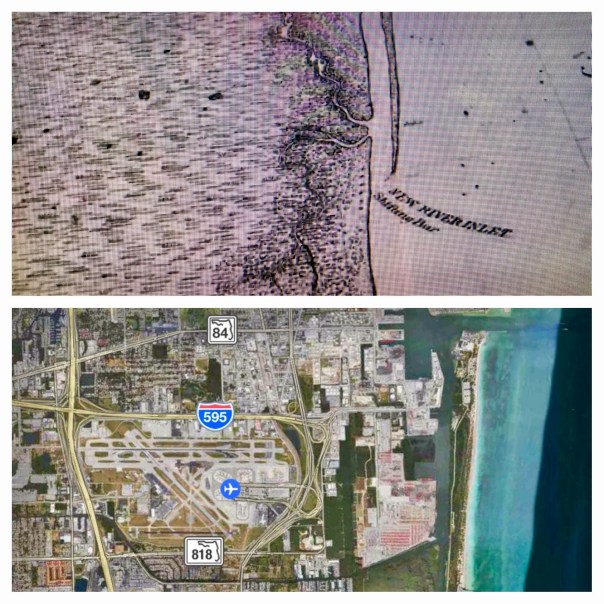


