Ed’s RV is having its annual so on August 16, 2023 Ed went up in the SuperCub with Scott Kuhns. It was early morning and lighting limited successful outcome of photographs. Thus I have chosen a just a few, that for me, are impactful in what they say about development and agriculture and our environment. JTL
Roosevelt Bridge, Stuart, Florida.North River Shores, Martin County, Florida.Tradition, St. Lucie County, Florida.Cutting up the western lands, Tradition, St. Lucie County, Florida.
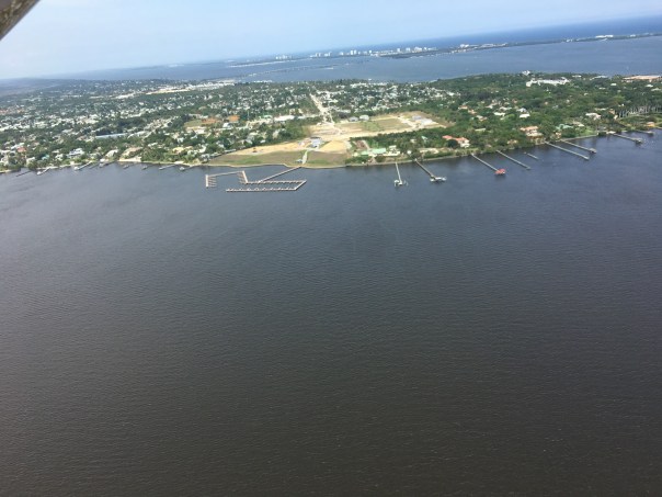
Sugar’s perfect water-control. Martin County, Florida.Blue-Green algae in St. Lucie Canal (C-44), Martin County, Florida.S-308 at Port Mayaca, St. Lucie Canal (C-44), Martin County, Florida.Ed as a passenger over Lake Okeechobee, SuperCub of Scott Kuhns, 2023.
-C-44 Reservoir filling up…Greetings. These aerials were taken November 26, 2021, the day after Thanksgiving, by my husband, Ed Lippisch, and his niece Darci. They took an after Thanksgiving flight and I made sure they took some pictures. It was a glorious Florida day!
Today, I am sharing Ed and Darci’s flight photos of the following:
-S-80 at St Luice Locks and Dam (gate open for C-44 basin runoff)
-And finally, the skinny, but very visible plume exiting at the confluence of the St Lucie River/Indian River Lagoon exiting the St Luice Inlet.
The water quality grade from Florida Oceanographic Society ending November 24th was a “B.” This is good news, however, seagrasses remain sparse and manatees are migrating due to colder weather, hungry, and deaths are way above average due to loss of seagrass throughout the Indian River Lagoon and other parts of the state.
The C-44 Reservoir will very much help improve water quality from the C-44 canal into the St Lucie River/Indian River Lagoon. This is a huge step and will be be majorly complemented by the EAA, and C-23/24 Reservoirs in the future. The C-44 Reservoir is being filled incrementally, checking for the structure’s integrity, and is expected to be in full service by the end of next year. Improved water quality is the only way to heal our waters and we need the EAA Reservoir to send the water south!
-Lake Okeechobee appears algae free. Looking east over Structure 308 and the C-44 Canal. FPL Cooling Pond left surrounded by agriculture, mining, and DuPuis Management Area.
-C-44 Reservoir is two and one half miles wide, and two miles long. Note pump station in left foreground. It is being filled slowly by the Army Corp of Engineers. The STA is in closest foreground.-Another angle-Back to pump station view
-C-44 Storm Water Treatment Area’s 6 cells cleansing and treating C-44 water were built by the SFWMD. Reservoir is visible far upper left. Note speck of pump station in the distance.
-Caulkin’s Water Farm is remarkably successful. It cleanses and stores water and was once a citrus grove. Such projects are funded by the Florida Legislature and managed by the SFWMD.
-Various angels of the C-44’s Structure 80, or “The Seven Gates of Hell” that allow both C-44 basin water and Lake Okeechobee water to disrupt salinity and pollute the St Luice River. The gate open in this photo is for C-44 basin water only. Many call this “local basin runoff,” but it is not. In 1916 C-44 busted through the natural ridge that historically separated the St Lucie from Lake Okeechobee.
-St Lucie Inlet looking north towards Sailfish Point. The runoff is from Canals C-44, C23, C-24 and runoff from all our our homes and streets, etc. Pick up dog waste! Don’t fertilize! Go to native and Florida Friendly plants; get on sewer if on septic; demand Agriculture follow Best Management Practices and prove accountability. SAVE OUR RIVERS!-St Lucie River at Witham Field. See you next flight!
The St Lucie River was originally a large fresh water “stream” that ran into the Indian River Lagoon. An inlet was cut in 1892.
First of all, let’s recognize that we are stressed out enough social distancing due to the coronavirus. Nonetheless, for our waters, we must pay attention on every front. Right now, the St Lucie River and nearshore reefs are absolutely beautiful, and there is not a threat from Lake Okeechobee or area canals as it is not raining very much. Lake Okeechobee is at 11.85 feet NVGD, therefore, the chances of discharges into the St Lucie River are basically none. If another Hurricane Dorian comes this summer, that could be a different story.
We know our waters suffer from nutrient pollution overdose. Thankfully the State Legislature under the leadership of Governor DeSantis is now paying attention. It will take some time for the bills passed this past legislative session to bear fruit and some will need to be expanded, but when it comes to our waters we are in a better position politically this year and last year than in recent years.
Nonetheless, we must continue our advocacy and continue to document.
The above Jacksonville Army Corp of Engineers map distributed during the March 31, 2020 Periodic Scientist Call shows how much water is going where from Lake Okeechobee. One can see that water for agricultural irrigation is being sent east into the C-44 Canal via S-308; at 191 cubic feet per second. This is fine, and I hope all the water users get the water they need, but algae blooms in our waters is a concern for me.
So to get tho the point, today I share my husband, Ed Lippisch and friend, Scott Kuhns’ flight photos taken today, April 2, 2020 around 11:00am. The aerials show the beginning of an algae bloom in Lake Okeechobee near the S-308 structure at Port Mayaca (Ed said it appeared much brighter than in the photos) as well as clearly in the C-44 Canal near the FPL retention pond and its structure S-153.
Continuing to fly east, there appears to be no algae at S-80, St Lucie Locks and Dam further down the C-44. Keep in mind, the water that is going into the C-44 canal via S-308 at Lake O, Port Mayaca is not going east through S-80 but being used before it gets that far for water supply in the western part of the almost 30 mile C-44 canal.
~Confusing, I know! The C-44 is long and has multiple abilities.
Here are the aerials, as long as possible, we will continue to document the St Lucie River and Lake Okeechobee.
BELOW: LOOKING EAST OVER LAKE OKEECHOBEE, FPL COOLING POND VISIBLE
BELOW: FAINT GREEN ALGAE CAN BE SEEN NORTH OF S-308 ALONG SHORELINE OF LAKE OKEECHOBEE FROM 2000 FEET.
ALGE NORTH OF S-308 and RIM CANAL LAKE O
BELOW: ENTRANCE OF S-308 AT LAKE O GOING INTO C-44 CANAL
BELOW: S-80, St Lucie Locks and Dam, further east along the C-44 Canal, no algae visible
SFWMD basin map for SLR showing S-308 and S-80 along with other structures.
My recent post about “Holding Lake Okeechobee’s Algae at Bay” got a lot of responses with a few questioning whether the algae bloom in Lake O off Port Mayaca was caused by the waters of C-44 flowing back into the lake.
I do not know the answer to this question, but I do know flights over the C-44 canal in 2019 have shown no visible algae blooms, but many in the lake with some right off Port Mayaca. Nonetheless, we know the C-44 is full of nutrient pollution.
Today I want to share a chart from my brother Todd Thurlow’s website http://eyeonlakeo.com/ as well as our back and forth on the issue of how much water has been put into Lake Okeechobee from C-44 so far this year rather than going into the St Lucie River. The ACOE can flow C-44 flow both ways…
Be sure to read “Summary of Query Results” below for the answer.
Todd: Jacqui, I changed my DBKey on my daily spreadsheet to S-308 just to see what it would spit out. See below. It looks like S-308 has sent a net 17billion gallons of C-44 basin water (over 54,000 AF) into Lake O this year. I am pretty sure that means we get a “free” 17billion gallons in our direction before it is considered “Lake Water”.
Jacqui: Todd did the ACOE start sending the C-44 canal water back to Lake O May 29th? Looking at the chart this is what I see.
Todd: There has been little flows all year as can be seen on the chart too but the big flows started on May 13 at -2042cfs. There was a pause between June 4 and July 30. Then is started again with a few days off here and there. Here is the data that is summarized in that chart.
The May 29 date that you might see (its actually May 20) is where the “Cumulative Total Discharge” graph crosses the zero axis? That is where the net flows for the year were back to zero. In other words, it took from May 13 to May 20, 8 days of westward flow, to cancel out all of the net eastward flow for the year.
SFWMD canal and basin map. C-44 can run east to the St. Lucie or west to Lake Okeechobee.
These DEP canal summaries are no longer available on-line but remain good references even though written in 2001.
1.Ed and the Super Cub 2019. Our “eye in the sky” since 2013.
2.Tip of South Sewall’s Point looking north to Hell’s Gate. Witham Field, Stuart, west.
We continue to document the discharges…
Yesterday, 3-17-19, my husband, Ed, flew the Super-Cub over the St Lucie River/Indian River Lagoon ~ twenty-one days after the ACOE started discharging from Lake Okeechobee on February 24, 2019.
When Ed arrived home, I asked, “So how was it?”
“Brown,” he replied.
“Like dark coffee brown, or kind of like that weird mixed greenish-brown?”
He looked at me, and smiled. “Jacqui, it was brown.”
“OK, I said, I’ll take a look at your photos.”
So here are the photos from Ed’s flight from Witham Field in Stuart, over Sewall’s Point and Hutchinson Island, then out west to S-80 to see the “Seven Gates of Hell” where you can see the one gate discharging now at an average of 250 cubic feet per second, down from an average of 500 cubic feet per second. As you can see from the SFWMD chart below, there has been other runoff locations as well, but the majority is from Lake Okeechobee.
3. Approaching the SL Inlet, algae covered remaining seagrass beds
4.Sandbar formation inside of SL Inlet
5.Blurry but shows boats at the Sandbar and that weird green brown color
6.Sailfish Point and SL Inlet algae covered remaining seagrass beds
7. Ernie Lyons Bridge, IRL with SL inlet and Hutchinson Island in distance
8. S-80 along C-44 Canal or the Seven Gate of Hell, boats going through locks, “250” cubic feet per second coming though
The following phots are of Caulkins Water Farm, a former orange grove that died due to citrus greening that now holds water from the C-44 Canal. This is a wonderful thing! As local ag-man Mr. Hadad, told me once, “Jacqui we spent 100 years taking the water off the land, and we’ll spend the next 100 years putting it back on.” The later photos are of S-80 again with view of C-44 canal leading west to Lake O.(https://www.facebook.com/CaulkinsWaterFarm/)
9.
10.
11.
12.
13.
14.
15.
16.
17.
18.
19.
20.
21.
22.
23.
24.
The following photos are when Ed headed back to Witham Field going once again over the St Lucie Inlet over the Atlantic Ocean. You can see the water looks blue north of Sailfish Point north of the inlet with nearshore reefs visible. Plume is also visible south of St Lucie Inlet. Also in photos is the winding Jupiter Narrows and St Lucie River in the area of Stuart and Rio. You can see Langford Landing with scraped orange soil and docks built into river still under construction since 2015.
Tarpon Fishing, Kent Hagerman 1893-1978. Courtesy, Sandra Henderson Thurlow.
Fishing map of McCoy Bros. SLR/IRL date unknown, notice the extensive tarpon fishing grounds, Thurlow Archives.
Tarpon on the line! Dave Preston
If we look into the mirror of history, we begin to see…
We begin to see how we destroyed one of the most famous and beloved inland fishing waters in North America and how we learned to do better. And if we are able, in time, not only to do better, but to return “health and glory” to the St Lucie River/Indian River Lagoon, it should be the tarpon, not the sailfish, that becomes our symbol, our king.
The first formal fishing club documented in Stuart was the 1916 St Lucie River Tarpon Club. The late 1800s and early 1900s were an era of great fame for the St Lucie River, build upon President Grover Cleveland and other presidents fishing trips to the area. Yes, the St Lucie was known as the “Fishing Grounds of Presidents.”
Ironically, at this same time, the Commercial Club, that evolved into today’s Chamber of Commerce, was promoting not just Stuart’s remarkable fishing, but also enthusiastically encouraging and awaiting the completion of the St Lucie Canal.
SFWMD canal and basin map. C-44 canal is the canal most southerly in the image.
“Once the muddy water flowed into the St Lucie River, they began to realize that the canal was not the blessing they envisioned,” writes Sandra Henderson Thurlow. Historian Alice Luckhardt more directly notes, “at one time tarpon were often caught in the St. Lucie River, but “disappeared” from those waters soon after the opening of the canal system to Lake Okeechobee in 1923.”
Ingeniously, and with more insight, in the years following the loss of tarpon and other river fish as seen in the McCoy map above, the ocean-going sailfish was marketed to replace the tarpon and become “the most prized fish of all…” as well as in time the symbol for both the city and county governments.
The magnificent Silver King? Just a dying memory, or no memory at all…
By the mid 1930s the Chamber of Commerce began publishing the “Stuart Fishing Guide.” In 1941 the largest sailfish run in Florida’s history occurred off the St Lucie Inlet. Remarkable! More than 5000 sailfish were caught in a 90 day period. “Thousands were slaughtered only to be dumped in the river, carted off by garbage collectors, and used for shark bait.” Stuart as the Sailfish Capital of the world was affirmed, but as my mother states, if “Stuart’s fame was to endure, so was the need for conservation of the species.”
The idea for conservation/protecting the industry had been in the works, the Sailfish Club had been talking about it and a few sailfish were returned to the ocean…. But after the sailfish run of “41, the idea of an organized conservation effort was solidified, and Sailfish Club of ’31 updated their charter in “41 “to further and promote sports fishing and conservation in the waters of the City of Stuart and Martin County.” Visiting sportsmen were awarded and inspired to work for the most coveted bronze, silver, and gold lapel pins based on the size of the sail they caught and released, not killed.
This is a great story, but what of the tarpon?
I can see his giant, ancient, dorsal fin rising from the waters of a healthier St Lucie River/Indian River Lagoon. For me, no fish will ever compare. As we restore our rivers, it is he who shall be KING! 🙂
Close up of solidarity fish on Florida’s Capitol steps, Clean Water/Amd. 1 Rally 2-17-15.) (JTL)
Rare wood cut map of St Lucie River, ca. 1885, by Homer Hine Stuart. Image shows water depth in heart of St Lucie River near today’s Roosevelt Bridge at 20 feet. (Courtesy of historian, Sandra Henderson Thurlow)
Homer Hine Stuart Jr., for whom Stuart, Florida is named. (Portrait courtesy of historian, Sandra Henderson Thurlow.)
Some days I get really lucky because people send me cool stuff based on what I wrote the previous day in my blog. Yesterday this happened with both my mother, Sandra Thurlow, Dr Gary Gorfoth and a slew of other comments . I will be sharing some of my mother and Dr Goforth’s insights today.
After reading my post on sediment loads in the St Lucie River/Indian River Lagoon and how they have lessened the natural depths of the river/s, my historian mother, sent me the awesome image of a historic wood cut at the top of this post created around 1885 by Homer Hine Stuart Jr., for whom Stuart, Florida is named.
This historic wood cut shows the depth of the St Lucie River at 20 feet in the area of what would become the span for the Roosevelt Bridge. A contemporary navigation chart below, shows the depth of the water in this area at 11 feet. At least 9 feet of sediment and or —MUCK!
Contemporary St John’s waterway navigation map, public files, shows the depth of the St Lucie River at the Roosevelt Bridge at 11 feet.
“Jacqui, Your post about sediments made me think of this little map. Homer Hine Stuart, Jr. for whom Stuart is named, had a little wood cut map that was about 4 by 2 1/2 inches and looked like one of those address stamps we use today made. Maps made from the wood cut were used to show his the location of his property and his bungalow “Gator’s Nest” to his family in New York and Michigan. This image was made from a photograph of the wood cut. It is printed is reverse so the writing, etc., isn’t backward. You can see that there was 20 feet of water depth between the peninsulas that would later be connected by bridges. The date of the map would be around 1885.” –Mom
Dr Goforth also wrote. He tells a sad story mentioning that Stuart News editor and famed environmentalist Ernie Lyons wrote prolifically about the great fishing in the St Lucie prior to the construction of the St Lucie Canal (C-44) in 1923.
“… the St. Lucie River and Estuary was known as the “Giant Tarpon Kingdom” before the Lake Okeechobee discharges began in 1923; after the Lake Okeechobee discharges began the muck from the Lake despoiled the clear waters and drove the tarpon offshore, and the area was recast as the “Sailfish Capital of the World” (Lyons 1975: The Last Cracker Barrel).
Thankfully, Dr Goforth gives an idea to fix and or improve the accumulation of muck sediments into the St Lucie River:
One effective means of reducing the sediment/much discharges from the Lake would be the construction of a sediment trap just upstream of the St. Lucie Locks and Spillway. This simple approach has worked well in other areas, most recently in West Palm Beach on the C-51 Canal just upstream of the Lake Worth Lagoon (see attached fact sheet). By deepening and widening the C-44 canal just upstream of the locks/spillway, a large portion of the sediment would settle out of the water in a relatively contained area before entering the River; with routine dredging, the material can be removed and spread over adjacent lands… —(perhaps using lands along the canal purchased by Martin County and SFWMD?). —-Dr Gary Goforth
Muck Removal using sediment trap, Lake Worth Lagoon, C-51, shared by Dr Gary Goforth.
Kudos to Dr Goforth’s ideas. Kudos to my mother’s history! Let’s get Governor Rick Scott towork and get to work ourselves too! We can do it. Together, we can do anything. 🙂
___________________________
MUCK THEMED PHOTOS:
Muck coats the bottom of our beautiful river but determination coats our hearts. We and future generations will continue to fight to save our St Lucie River/Indian River Lagoon!
Muck from St Lucie River, covering oysters, 2014.
Jim Moir teaches Hannah Lucas about muck at the River Kidz GET THE MUCK OUT event, March 2014.
Muck Buster, River Kidz 2014.
My close up photo of front page Stuart News article where Kevin Powers of the SFWMD shows Gov. Rick Scott a shovel full of muck from around Power’s dock in Stuart. 2014. (Photo Stuart News)
Mark Perry and I display our “muckstaches” for Florida Oceanographics fundraiser/awareness raiser, 2015.
River Kidz GET THE MUCK OUT campaign and bumper sticker, 2014.
“Atlas of Florida Growers,” 1909- original map of Palm Beach County. (History of Martin County, 2nd. Ed 1998.)
Looking at this old 1909, original, Palm Beach County map, the book, “The History of Martin County” states:
“…extending from Stuart on the north line to a line three miles south of Pompano Beach was Palm Beach County.”
It continues: “The southerly ten miles was subtracted and included in the creation of Broward County in 1915, and in 1925, the northerly seventeen miles was lost to Martin County.”
It is interesting to think that “we,” Martin County, were once a part of Palm Beach County that is so different from us today in terms of land development and water theory.
In 1909, the C-44, or St Lucie Canal, had not been connected to the South Fork of the St Lucie River/Indian River Lagoon. What a paradise it must have been! Oh the fishing and wildlife!
Original Palm Beach Map, 1909.
Nonetheless, no matter what “county” one was in, people were draining the land and altering the fishing and wildlife….that is what has led us to where we are today. “White”settlers lived along the New River Canal, the canal second from the west on this map, as early as 1830s. 185 years!
Knowing our history, allows us to change our future. Knowing we were once part of something many of us now separate ourselves from brings perspective….
An interesting document to peruse regarding this situation is by the South Florida Water Management District entitled “Canals in South Florida.”
As we fight for a better water future, the more we know, the further we will go! Take a look and enjoy.
This aerial shows the area of the future almost 10,000 acres that will become the C-44 Storm Water Treatment Area and Reservoir. A landmark of this area is Indiantown Airport, a grass strip located above and north-east of the lake in this photo. So far the C-44 STA/R. project’s four mile intake canal has been built. The immense lands beyond, east, north and west of this area will become the STA and Reservoir.
I spend a good amount of time studying the St Lucie River/Indian River Lagoon; nonetheless, I am constantly amazed to learn what I don’t know. In a nutshell, the C-44 storm water treatment and reservoir is part of the Indian River Lagoon South Project to clean up the St Lucie River/Indian River Lagoon by storing and cleaning water from our huge C-44 basin.
The project is part of the Comprehensive Everglades Restoration Plan and even though I have read about it for years, I did not know how or the order of it being built. Today I will share my experience in learning just the beginning.
To look back a bit for the history, building the C-44 storm water treatment area and reservoir is combined effort of many years of work of local, state and federal governments and it is one of the most expensive water projects being built in the Florida, with an estimated costs of almost 4 million to complete.
I wanted to SEE this because it is so hard to understand it all.
So a few weeks ago my husband Ed, and his friend Shawn and I are flying over this area and I’m saying “where is it? It’s supposed to be here. I want to take some pictures. Hmmm? I don’t see anything…I was expected a big lake like thing off of the C-44 canal or something.”
Ed calmly, says: ” This is it Jacqui. Over the past years the ACOE has been working hard to build this new intake canal. We have seen it for years as we fly over. It must be built first probably; you can see the results.”
So we flew north over the four mile intake canal that finally stopped in a wilderness of agricultural lands.
Intake canal on east, agricultural lands on west.
End of intake canal.
The intake canal was completed in July of 2014 at of cost of 28 million dollars. This is huge accomplishment and this is only the beginning. This is what we can SEE so far.
So what will we SEE in the future?
To get an idea as seen below, the FPL cooling pond off the east coast of Lake Okeechobee is 5,000 acres. The C-44 STA/R. will be almost 10,000 acres. So in the future, when one looks at a Google Maps, there will be another gigantic lake looking thing consisting of the STA (6300 acres) and the reservoir (3, 400 acres) east, north and west of the Indiantown Airport, the red dot below.
Area from Lake O following C-44 canal to St Lucie River in Stuart.
Indiantown Airport along C-44 canal.
Map of C-44 STA/R black. Basin in pink.
Engineering map from ACOE/SFWMD showing where the cells of the C-44 STA/R. will be.
The monies and energy needed to build the C-44 STA and reservoir is and has been tremendous. In spite of one’s political affiliations or the project itself, we must recognize those who have recently helped ensure the success of the project: the SFWMD, the ACOE, Senator Joe Negron, Governor Scott, Congressman Murphy, the Martin County Commission and the public. I am sure there are many others that I do not know. This gigantic project has taken many years and has been no easy feat. Kudos to the decades of people who have worked to make this first step of the intake canal possible. I recognize your efforts.
Yes it is good to be positive, the C-44 STA and Reservoir is a great start, but it is important to also realize that the resovoir will hold about 50,000 acre feet of water. During some storm seasons we get much more than that just from the C-44 basin alone, and that is NOT counting releases from Lake Okeechobee.
We have a lot more work to do, to get to where we want to be, but finally we are beginning to SEE RESULTS of something getting built to help improve water quality, and that is something more than Martin County has ever seen before in its long fight to save its treasured St Lucie River and Indian River Lagoon.
The St Lucie River basin/drainage map 2013, SFWMD.
For thousands of years, before the intervention of modern man, the Ais Indians walked the banks of a large fresh water “stream,” that flowed to the Indian River Lagoon. When the Seminoles came years later, they called it Halipatiokee, Alligator Water, as it was fresh and full of gators. The Spaniards came in the 1500s, on and off for centuries. They first called the river, Rio de Santa Cruz, river of the Holy Cross, as the river is cross-like. Later, they re-christened the river Rio De Luz , river of light, for the lighting on the water is heavenly. Eventually, the Spanish called the river, Santa Lucea. The English then taking over, “anglicized” the name Santa Lucea, to what we know today, as “St Lucie,” the church’s saint of the blind, and of “vision.”
1883 Geodetic Survey, Indian River Florida, St Lucie River.
Unfortunately, there was not much long-term vision when the watersheds around the St Lucie were altered by modern man. In 1892 area pioneers cut a permanent inlet from the St Lucie River/Indian River Lagoon to the Atlantic Ocean, killing the native fresh water grasses that supported an entire ecosystem. Nonetheless, they created something wonderful, the brackish estuary we all know today. This area, over the years, before its recent destruction, became one of the most bio diverse estuaries in North America.
That wasn’t enough, the local people and the state, with the help of the federal government’s Army Corp of Engineers, decided they wanted a connection to Lake Okeechobee for trade, travel, agriculture and the convenience of keeping the big lake of Okeechobee, “low.” So they built the C-44 canal connecting Lake Okeechobee to to the St Lucie “River.” In high water times, the overflow from the lake was directed into the St Lucie River as it is today. Later, around the late 1950s the people decided they wanted more drained land for orange groves and development in the north, and less flooding, so they got the state and federal government to build the C-23, C-24 canals in Martin and St Lucie counties, draining some areas that had never flown south before. These canals even drained lands out west, in what is now Okeechobee County, and in the north, known today as the City of Port St Lucie.
Did the people building these canals ever think about the effects on the Saint Lucie River? This seems doubtful. And so today, we have a river system that takes on much more water than it was ever meant to receive.
As Ernie Lyons, the former great environmentalist and editor of the Stuart News wrote in the 1960s about the loss of the headwaters of the South Fork of the St Lucie River during his lifetime:
“…The drainers got to work on the marshes. The cypress bordered ponds became white sand in the dry times. A ditch through them gushed silted floods during the heavy rains. The little stream was ruined. It turned from paradise to paradise lost…”
Not until really the 1970s did humankind start to reflect and realize that we literally were killling paradise, and we have been trying to revive the spirit of the St Lucie River/Indian River Lagoon ever since.
With out a doubt, the spirit of the saint still lives in the St Lucie River; her ancient story is that she lost her eyes to give the people their own “to see .” When you drive over the bridge and look at her, the beautiful St Lucie, open your eyes and ask her to give us all, “better vision.”