Pilot my husband, Dr Ed Lippisch, Dr Gary Goforth, Mark Perry Feb. 9, 2020
Between the rain and the FAA’s Presidential Temporary Flight Restrictions, it has been difficult this Florida winter to get photos of the St Lucie River/Indian River Lagoon. Luckily, yesterday, there was an opportunity to get up in the air!
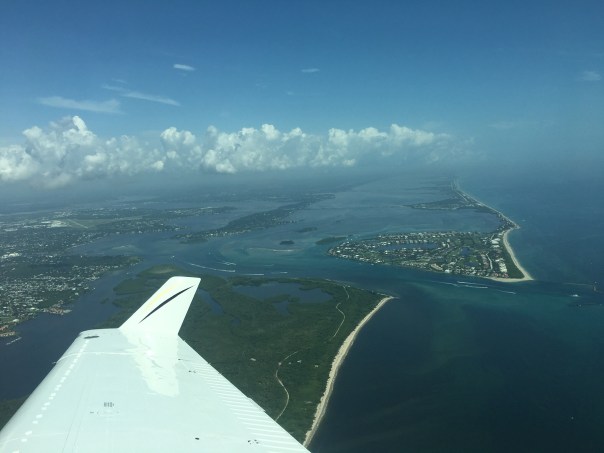
Ed took Florida Oceanographic https://www.floridaocean.org Executive Director, Mark Perry, and board member, Dr Gary Goforth up for a ride. Mark wanted to check on the seagrasses and near shore reefs. Gary – the restored Kissimmee https://www.sfwmd.gov/our-work/kissimmee-river as he was very much part of this success that is still underway. As it was quite windy and I have a delicate stomach, I stayed on the ground. I didn’t want to ruin the outing asking for an air-sick bag!
Today, I share some rare photos of the St Lucie River after being “Lake Okeechobee discharge free” for almost one year. As you can see, her seagrass beds still need a few more years to recover, but rhizomes and grasses are back in some areas, ~but not what we want- historic “all.” The ocean waters were very turned up so it was hard to see the reefs, but the water sure was blue and for that we are beyond thankful!
Ed and I and the River Warrior Community will continue to document and fight for the continued health of our St Lucie River/Indian River Lagoon!
South of Sewall’s Point, Crossroads, photo Gary GoforthSt Lucie Inlet, near shore reefs, photo Ed LippischAnother view, photo Ed LippischIndian River Lagoon, Sailfish Flats, photo Ed LippischSailfish Point, IRL/SLR Crossroads, photo Ed LippischRestored area of the Kissimmee River, photo Gary Goforth
My husband, Ed, was able to fly the Baron yesterday. As the plane has been in service, we have not taken photos of Lake Okeechobee or the St Lucie River from a higher altitude in almost two months.
Because the satellite images have been showing Lake Okeechobee’s bloom lessening, I wasn’t sure what Ed would find. Well, he found a large blue-green algae bloom right outside the gates of Port Mayaca at S-308.
On his way back to Stuart, he also took pictures of the St Lucie Inlet showing plentiful seagrass recovery near the Sandbar at the confluence of the St Lucie River/Indian River Lagoon, the ocean/river looking blue and inviting ~ not like the black coffee sediment and toxic nutrient-filled discharges seen recently in 2013, 2014, 2016, 2017, and 2018.
I am thankful to the ACOE and all involved for this summer’s reprieve. The Saint Lucie River really needed it!
We must keep in mind that with all of the recent rain, of course, Lake Okeechobee is rising. Today lake is at 12.99 feet. Hopefully, in the coming and most active months of hurricane season, there will not be a tropical system that could rapidly increase the lake level. In years past hurricanes have brought as much as three or four feet. There are many factors, but usually, the ACOE starts releasing at 15.5 feet to protect the Herbert Hoover Dike’s integrity and those living south and in the shadow of our diked lake.
Humans may have figured out how to “control” the state’s water, but Mother Nature holds the final card.
SFWMD 8-19-19
LAKE OKEECHOBEE AT PORT MAYACA AND LAKE O’S N.E. RIM SHOWING ALAGE BLOOM. IF S-308 were open, this bloom and freshwater that sustains blooms would be pouring into the St Lucie River/Indian River Lagoon. Photos by Ed Lippisch 3-18-19.
Lake O
N.E. Lake Okeechobee and Rim Canal
Boat tracks through algae bloom off Port Mayaca
Looking toward Lake Okeechobee at S-80, A.K.A. “The Seven Gates of Hell.” These gates can be opened by the ACOEO to discharge water from Lake O into the St Lucie River. Photo Ed Lippisch 8-18-19.
C-44 Canal connects Lake Okeechobee to St Lucie River, photo Ed Lippisch 8-18-19
ST LUCIE RIVER/INDIAN RIVER LAGOON AT ST. LUCIE INLET showing nearshore reefs, blue waters, and recovering seagrasses ~even with high local rains and discharges from canals C-23, and C-24. This area between Sewall’s Point and Sailfish Point was once considered the most bio-diverse in North America. This year, 2019, there have been no discharges from Lake Okeechobee allowing the area to begin to recover from years of destructive discharges from Lake Okeechobee.
St Lucie Inlet at the confluence of SLR/IRL, #Clean2019
Darker shades are recovering seagrasses!
Flight Aware Track:
SFWMD canal and basin map. C-44 canal is the canal most southerly in the image and connected to Lake Okeechobee.
Hurricane Irma may be gone, but her waters are not. Our now black river and the giant plume off the St Lucie Inlet attest to this. Clean rain that fell in our region during the hurricane is now filthy “stormwater” discharging, unfiltered, through manmade canals C-23, C-24, C-25, and C-44. Nature did not design the river to directly take this much water; this much water kills.
Every plume looks different, and this one is multilayered with no clear border. Sediment soup, black-brown in color, yesterday it extended out about 2/3 of a mile into a stirred up Atlantic and flowed south, in the rough waves not quite having made it to Peck’s Lake.
Since Hurricane Irma’s rains, area canals dug with no environmental foresight in the 1920s and 50s for flood control, and to facilitate agriculture and development, have been flowing straight into the river. On top of this, in anticipation of the hurricane, three days prior to IRMA the Army Corp of Engineers began discharging from Lake Okeechobee. During the hurricane they halted, and then started up again at high discharge levels reaching over (4000 cfs +/-) this past Friday, September 15th. As Lake Okeechobee rises and inflow water pours in from the north, and is blocked by the Everglades Agricultural Area in the south, we can expect more Lake O discharge on top of the canal releases themselves.
As advocates for the St Lucie River we continue the fight to expedite the building of the EAA reservoir and to create a culture to “send more water south.” In the meantime, we, and the fish and wildlife, and the once “most bio diverse estuary in North America,” suffer…
My brother Todd, has complied many other links on his website’s favorites under St Lucie River and ACOE/SFWMD: http://www.thurlowpa.com/news.htm
Post Irma flight over St Lucie River/IRL 9-17-17
SFWMD canal and basin map. C-44 canal is the canal most southerly in the image. All canals shown here discharge into the SLR/IRL.The confluence of the St Lucie River and Indian River Lagoon at Sewall’s Point, an area once full of seagrasses and fisheries and formerly considered the heart of “the most bio diverse estuary in North America.”Waves in plume breaking over offshore reefs; looking north to Hurchinson Island.Southern edge of plume along Jupiter Island and Jupiter Narrows south of St Lucie Inlet.
Looking south off St Lucie Inlet.South edge of plume looking south towards Jupiter Island.
TCPalm’s Elliott Jones reported this morning that Stuart has received a whopping 11.30 inches of rain just so far this month! (The average being 7.14.)
Although due to the recent drought, the ACOE/SFWMD are not dumping Lake Okeechobee through Canal C-44, canals C-23, C-24, C-25, and areas along C-44, as well as our own basin, are draining right into the St Lucie River/Indian River Lagoon. Very little of this water is cleansed before it enters and thus is damaging to the eco system. Next time you see water draining through a grate in a parking lot, think about this. Remember too that before the major canals were constructed the 1900s, the river received less than half the water it gets every time it rains today.
SLR at “Hell’s Gate” looking at Sewall’s Point, Sailfish Point and the St Luice InletDrainage changes to the SLR. Green is the original watershed. Yellow and pink have been added since ca.1920. (St Lucie River Initiative’s Report to Congress 1994.)
The aerials below were taken 6-13-17 by my husband Ed Lippisch and pilot Dave Stone. It is important to monitor the river all of the time so we can view changes.
“Rain stained” we are; please remember not to fertilize during the rainy season. The birds on Bird Island will appreciate it! (http://befloridian.org)
TC Palm, Elliott Jones, 6-19-17Bird Island, IRL east of Sewall’s PointBird IslandIRL St Lucie Inlet and Sailfish PointSailfish Flats, IRLCrossroads, confluence SLR/IRL off Sewall’s PointSpoil Island off Sailfish, bird also roosting here!Sick looking seagrass beds in IRL looking south towards Jupiter Narrows““SL Inlet near Sailfish Point, no black plume but darker colored watersJupiter Island’s state park at St Lucie InletSailfish PointSt Lucie Inlet looking southinlet againClear ocean water at jetty, St Lucie InletLooking back to St Lucie Inlet mixed colored waters but not black as with Lake O water releasesSt Lucie Inlet between Jupiter Island’s state park and Sailfish Pointinlet againLooking north to SL InletJettyHutchinson Island and Sailfish Flats in IRL. Sewall’s Point in distance.Parts of the Savannas near Jensen , IRL and Hutchinson Island in distanceSavannas State Preserve Park
Canals draining water into SLR/IRL after rain events:
St Lucie River/Indian River Lagoon, Martin County, FL (JTL)Port of Miami, Biscayne Bay, Miami, FL (JTL)
Today my husband, Ed, is going to take you on a flight south along the Atlantic Coast from the St Lucie River/Indian River Lagoon in Martin County, to the Port of Miami. As we know, the coastline becomes more and more developed as one flies further south. Bright blue skylines of houses and condos morph into shadowy silver skyscrapers, and cargo ships. Expansive greenery slowly disappears…
I, probably like you, know people who grew up in Miami, Ft. Lauderdale, or Palm Beach County who have moved to Martin County to get away from the over-development and traffic nightmare of “down south.” Many tell stories about things changing “overnight,” and no longer recognizing the place they called home.
The “Martin County Difference,” its slow development, is not by accident. Many throughout the years have fought to keep our area less traversed than the rest of South Florida. One thing is for sure, if you want to keep it, you have to fight for it, or otherwise it will be going, going, GONE…
Ed’s tour-view, from the air, really makes the comparison hit home.
(Please see map of cities passed in flight, and 28 photos or slide show below.)
Ed your pilot and tour guideCoastal flight from Stuart/Palm City/Hobe Sound in Martin County to Miami and Key Biscayne.
This slideshow requires JavaScript.
I am having technical problems with this post; long up-loading and off links. I do apologize and will get worked out. Jacqui
Western side of C-44 Canal at S-80, St Lucie Locks and Dam. This structure discharges water from Lake Okeechobee and the agricultural C-44 basin created to drain lands into the St Lucie River/IRL. (Photo Dr Scott Kuhns, 6-22-16)
Today we will get a science lesson and see some new shocking photos…
Eutrophication: (Ecology.) (of a lake) characterized by an abundant accumulation of nutrients that support a dense growth of algae and other organisms, the decay of which depletes the shallow waters of oxygen in summer.
Today’s blog shares new aerial photos by Dr Scott Kuhns taken 6-22-16 of the extensive blue-green algae cyanobacteria bloom on the western side of the C-44 Canal being sent through S-80. The photos show a condition caused by mixture of polluted Lake Okeechobee and C-44 agricultural basin water filled with an overabundance of nitrogen and phosphorus primarily from decades of intense agricultural farming north, south and around Lake Okeechobee. Scientists have documented this condition of “eutrophication” since the late 1960s and predicted it would worsen unless serious corrections were put in place.
These nutrients, now out of control, feed algae blooms and have caused the eutrophication (or overabundance of algae growth) of Lake Okeechobee. The St Lucie River is now experiencing this due to our manmade connection to the lake. Our agricultural canals of C-44, C-23, C-24, and C-25 are culprits too. The giant releases from the lake and canals make our river fresh and seeded with algae water. Sometimes growing toxic.
The bloom on the west side of S-80 at St Lucie Locks and Dam was first documented by local activist this time in late May. The ACOE has been dumping since January 29, 2016. The river is now almost entirely fresh. Perfect for blooms.
Yesterday the St Lucie River went up in algae with multiple reports throughout the entire river from Palm City, Rio, Stuart, Jensen, and Sewall’s Point. Could there be a correlation considering the bloom started in the eutrophic lake ? How could there not be.
Dr Kuhns’ comment?
“Ridiculous!!! What does it take?”
We should not be connected to the lake. Agricultural canals should be redirected. There must be storage to treat this algae water. It should not be sent into our estuary destroying property and the environment.
C-44 at S-80 St Lucie Locks and Dam looking east. Scott Kuhns
Today I will share aerial photos of the Manatee Pocket area around Sandsprit Park taken yesterday by my husband, Ed Lippisch, and a short written update by Dr Gary Goforth dated 6-12-16.
Manatee Pocket lies close to the St Lucie Inlet just across from Sewall’s Point. It once was the mecca for the St Lucie River/Indian River Lagoon commercial fishing business. The Lake Okeechobee discharges continue having started by the Army Corp of Engineers January 29th of this year and are approaching the level for all of 2013. Lake Okeechobee yesterday was reported to stand at a very high for this time of year 14.77 feet—-There is no end to discharges in sight for the St Lucie River. Conditions are very bad and the state and federal government are stuck in a pattern that is killing our quality of life and economy.
There must be a better way…
For the St. Lucie, the 2016 Lake discharges: – exceeded 133 billion gallons (compared with 136 billion gallons for 2013) – dumped more nitrogen, phosphorus and sediment than the “Lost Summer” of 2013 – dirtier than 2013 (higher concentrations of nitrogen, phosphorus and suspended sediment) – have exceeded the nitrogen and phosphorus TMDLs for the C-44 Canal by 600% For the Caloosahatchee, the 2016 Lake discharges: – have exceeded 302 billion gallons (compared with 456 billion gallons for 2013) – are dirtier than they were in 2013 for nitrogen and phosphorus
Gary Goforth, (garygoforth.net), 6-12-16
Photos of SLR at Manatee Pocket, Ed Lippisch, 6-15-16.
“1933 photograph shows Hugh Willoughby flying over Sewall’s Point and Willoughby Point in Port Sewall. The insignia of the New York Yacht Club is on th side of the biplane.” (Photo, Dale M. Hudson from Sandra H. Thurlow’s book “Sewall’s Point, A History of a Peninsular Community of Florida’s Treasure Coast”.)
One of my favorite aerial photographs from my mother’s history books on Martin County is of the infamous Hugh Willoughby flying over the St Lucie River at Sewall’s Point and Willoughby Point. In more familiar terms for boaters, this location is known as “Hell’s Gate” due to the bottle-necking of the rushing tide.
Mr Hugh de Laussat Willoughby, one of the “early birds” of aviation, and a resident of Sewall’s Point, (http://earlyaviators.com/ewilloug.htm) had the idea of locating the New York Yacht Club at the southern tip of the peninsula as envisioned in the map below. It is difficult to see in the aerial, but the insignia of the New York Yacht Club is on the side of the biplane.
The yacht club never materialized as the market crash of the late 1920s and following depression of the 1930s dashed that dream. Today many local pilots fly over the St Lucie River at this same location to photograph a different dream. –By showing the devistation, inspiring a dream for our state and federal agencies, of clean water…
Would Mr Willoughby ever have imagined his paradise would be one of controversial pollution? Never in a thousand years….
This year, the ACOE has been discharging from Lake Okeechobee since January 29th 2016; in 2013 they released May through October, and in 2014 nothing…
May the photographs or today’s ailing river inspire change, and may the spirit of Mr Willoughby keep adventure and love alive in our hearts—and the wind— ever at our backs.
New York Yacht Club Station courtesy of Sandra H. Thurlow.Cub taking photo of a cub, pilot Ron Rowers. (Photo Scott Kuhns, 2014, St Lucie River, Stuart.)St Lucie River at Sewall’s Point and Willoughby Point 2016 with dark waters from Lake O releases and area run off. (Ed Lippisch)….further away–Hell’s Gate.Sewall’s Point and Willoughby Point, 2016Sewall’s Point and Willoughby Point 2014.JTLEast side of Sewall’s Point and confluence SLR/IRL Lost Summer–(JTL)2013 SLR JTL
Lake Okeechobee’s S-308 at Port Mayaca, Ed Lippisch, May 13, 2016.
The first time I ever laid eyes on Lake Okeechobee, I was eleven years old. I remember thinking that I must be looking at the ocean because I could not see across to the other side. Just enormous!
In spite of its magnificent size, over the past century, Lake Okeechobee has been made smaller–around thirty percent smaller– as its shallow waters have been modified for human use–pushed back, tilled, planted, diked, and controlled. Today, it is managed by the South Florida Water Management District and the Army Corp of Engineers. Sprawling sugar fields, the Everglades Agricultural Area, (EAA), canals, highways, telephone poles, train tracks, processing facilities, a FPL power plant, and small cites surround it.
S-308, (the “S” standing for “structure), opens easterly into the St Lucie Canal, also known as C-44, (Canal 44). About twenty miles east is another structure, S-80, at the St Lucie Locks and Dam. It is S-80 that is usually photographed with its “seven gates of hell,” the waters roaring towards the St Lucie River/Indian River Lagoon, and the City of Stuart, but it is actually S-308 that allows the waters of Lake Okeechobee “in” from the lake in the first place.
Such a fragile looking structure to be the welcome matt of so much destruction…a sliver unto an ocean. So strange…
Today I will share some aerial photos that my husband took on Friday, May 13th, 2016 at about 700 feet above the lake. I asked Ed if from that height he could see the algae bloom so much in the news last week even though over time blooms migrate, “bloom” and then sink into the water column, becoming less visible but still lurking.
“Yes.” He replied.
” It’s harder to see from that altitude, and it depends on the light, but it’s still visible. It’s green in the brown water. The lighting shows were it is. You can see a difference in texture about 100 yards west of S-308. It is not right up against the structure, but further out. Boats are driving through it leaving a trail. It’s appears that is slowly being sucked in to the opening of the S-308 structure , like when you pull the drain out of the sink….”
S-308 at Port Mayaca, Indiantown, Martin County. Ed Lippisch, 5-13-16Dike and rim canal around Lake Okeechobee near S-308. Ed Lippisch, 5-13-16…ELopening S-308 EL…Looking towards S-308 from Lake O, boat going through bloom. Ed Lippisch, 5-13-15Remnants of bloom seen bunched in waves. Ed Lippisch 5-13-16.…EL…EL……ELC-44 or St Lucie Canal that is connected by S-308 to Lake Okeechobee.ELCloser view of algae bloom in C-44 near Indiantown “downstream” of Port Maraca and S-308 headed to Stuart. (JTL 5-10-16)SFWMD SLR basin and canal map showing S-308 and S-80 along with other structures.Algae Bloom in Lake Okeechobee: This aerial was taken last week by Will Glover as he was flying over Lake Okeechobee in a commercial airplane. It was shared on Facebook.
TC Palm’s Tyler Treadway reported on 5-13-16: “The lake bloom was spread over 33 square miles near Pahokee, the South Florida Water Management District said Thursday. The Florida Department of Health reported Friday the bloom contains the toxin microcystin, but at a level less than half what the World Health Organization says can cause “adverse health impacts” from recreational exposure.”
Pahokee is south and west of Port Maraca and S-308. (Florida Trails)
Willoughby Creek in Stuart, Martin County 1949. Photo courtesy of Sandra H. Thurlow.
Today I will share an historic aerial photo along Willoughby Creek together with a brief history lesson by my mother. Following, there are recent Google Map photos to compare…Stuart is still “paradise,” but sometimes I wish I were born 100 years ago. 🙂
“Jacqui, I came across this in my computer and thought it might be interesting for you to see. The date is Feb. 26, 1949. You can see Marvista… I think the house in the middle is the one that became Lee Rasch’s home. Patty Irons Child’s mother, Marge Irons was Lee’s second wife. The house at right was originally “Lagunita” built by Hugh Willoughby, Sr. (There is a big write-up on it on page 158 of the History of Martin County.) It later became a small hotel-like place call “Inlet Tides.” Both of the structures on the right side have been demolished… I am sure you know that Marvista was built by Hugh Willoughby, Jr. in 1924-25.”
—-Sandra Henderson Thurlow, Historian
You may have to “look” a bit, but if you do you will find Marvista and Lagunita today.
…2016….2016…2016 Blue dot is my home in Sewall’s Point not Willoughby Creek area. The islands that housed Marvista and Lagunita are near the left upper part of the upside side down triangle in the area of Hell’s Gate.
Today we look back in history….but you have to look….
These historic photographs are marked “Fairchild Aerial Surveys, Inc.”
According to Mr. John H. Canada, president, Ocean Naval Architects, the year was 1925. You may recognize one of the images as it was used in a former blog post discussing the piled up sand of the C-44 canal. From 1915 to 1925 the government was connecting the canal from Lake Okeechobee to the St Lucie River and Indian River Lagoon. A big mistake!
These photos below were originally sent to my mother, historian, Sandra Thurlow, by Mr John Whiticar. In their discussion, it is noted that one can see farming where Indian River Plantation is today (The Marriott); one cannot see an Intercostal Waterway–no spoil islands off Sewall’s Point; there was no development on Rocky Point; and most interesting for me, looking at the photo this time: today’s Martin County Golf Course, part of yesteryear’s “Sunrise Inn,” sits right there “in the middle of no where” in 1925. Those were the days!
Atlantic shoreline just south of St Lucie Inlet along Jupiter Island contrasting 6-20-15 clear waters to of 9-8-13’s dark waters. Dark waters reflect discharges from Lake Okeechobee and area canals C-23; C-24, and C-44. Blue waters reflect “no rain” and no dumping for one month from the ACOE and SFWMD. (Photos Jacqui Thurlow-Lippisch and Ed Lippisch)
Monday’s blog contrasting the beautiful, blue-waters of the St Lucie River/Indian River Lagoon this summer in 2015, to the silty, dark-brown waters of the “Lost Summer” of 2013 was well received, so today will post some more photos of this “contrast.”
My husband, Ed, encouraged me to do more framed contrast photos; however, time does not permit so there is just one “framed” photo above and the rest will be separate photos. I will try to do more framed ones in the future.
Also, although Ed and I have taken thousands of photographs, they do not always “match up” in location so the visual perspectives are not “exact.” My goal while in the plane is simply to hold on to the camera, hoping it does not fall into the river. It is always very windy in the open Cub. Getting a good photo is just secondary! I mostly just use my iPhone.
Well, a picture speaks a thousand words….” so I’m not going to “say” anything else…All photos are contrasting June 20th 2015 with either August 11th or September 8th of 2013.
Thank God we having a beautiful summer!
Bo and Baron, our dogs, sitting by the Cub Legend, the plane used for most of the photographs. (JTL) In 2013 it was christened the “River Warrior” plane. 🙂St Lucie Inlet looking west towards Stuart, Sailfish Point barely visible on far right of photo. Jupiter Narrows and “Hole in the Wall “on right. June 2015.St Lucie Inlet September 2013 looking north east towards Sailfish Point. Plume heading towards St Lucie Inlet.
Looking northerly towards Sailfish Point and St Lucie Inlet. Sailfish Flats between Sewall’s Point and Sailfish Point are visible here. Sewall’s Point is to the right or west of this photograph. (June 2015.)Looking north toward Sewall’s Point on east/left. The Sailfish Flats are to the right/east as is Sailfish Point. (September 2013.)
Shoreline of Jupiter Island June 2015.Jupiter Island ‘s Atlantic shoreline Sept 2013.
Sailfish Flats between Sailfish and Sewall’s Point 2015.Seagrasses remain decimated and covered in algae.They come back very slowly.Wideview of Sailfish Flats area between Sewall’s (L) and Sailfish (R). Points. (Aug 2013)
St Lucie River, west side of Sewall’s Point 2015. Point of Hell’s Gate visible on to east/right. June 2015.St Lucie River, west side of Sewall’s Point looking towards Evan’s Crary Bride. Hell’s Gate is on east/right but not visible in this photograph. August 2013.
The remainder below do not match at all, but provide contrast:
St Lucie Inlet June 2015.St Lucie Inlet June 2015.Hutchinson Island looking south to St Lucie Inlet, June 2015.Blurry but St Lucie Inlet in sight with near shore reefs south of of inlet very visible. (June 2015) These reefs have been terribly damaged by the years of releases from Lake O and the area canals (silt and poor water quality) even though they are “protected” by the State and Federal Government.
Crossroads SLR/IRL to St Lucie Inlet (R) with Sewall’s Point on left. Looking at flats area full of seagrass that bas been damaged again and again by releases. Once surely considered the most “bio diverse estuary” in the North America–1970s Grant Gilmore. Photo August 2013, it is surely not today.Same as above but closer to Sailfish Point nearer St Lucie Inlet Sept 2013.Crossroads Sept 2013.Looking toward Palm City Bridge 2013. St Lucie River.IRL side east of Sewall’s Point September 2013.Inlet area looking at Sailfish Point and St Lucie Inlet 2013.South Sewall’s Point’s waters at Crossroads of SLR/IRL near inlet, 2013.St Lucie Inlet 2013…..
Confluence of St Lucie River/Indian River Lagoon between Sewall’s Point and Sailfish Point, Hutchinson Island, “The Crossroads,” 3-8-15 showing releases from Lake Okeechobee and area canals. (Photo Ed Lippisch)
Usually, my husband, Ed, does not like it when I ask him to “do things”…like take out the trash or blow leaves off the driveway. But he always likes it if I ask him to go up in the plane. He did so yesterday, and was able to visually document the polluted discharges pouring into our St Lucie River/Indian River Lagoon.
Yes, once again.
The Army Corp of Engineers (ACOE), and the South Florida Water Management District (SFWMD) agreed to have the Army Corp start releases this year on January 16, 2015 at 200 cubic feet per second (cfs) through S-308 into the C-44 canal which is attached to the South Fork of the St Lucie River, and then in turn is connected to the Indian River Lagoon “my town,” Sewall’s Point.
Exhausting isn’t it?
The ACOE is now discharging at a rate of “950 cfs.” This rate goes up and down. It is going up because Lake Okeechobee is not going down…
This SFWMD basin map also shows S-308 at Lake O, the C-44 canal, S-80 at St Lucie Locks and Dam, SLR/IRL.
Today I will share Ed’s photos and show how to “see” how much the ACOE is releasing at S-308. (Structure 308) which is located at Port Mayaca, in Indiantown, Martin County.
Ofcouse, there are discharges from area canals C-44, C-23, C-24 and C-25 as well, but today for simplicity’s sake, I will focus on the lake discharges today, which in my opinion, are the worst of all anyway—because they are not at all “ours.”
So—–
You can search “Jacksonville, ACOE” or just go to this link: (http://w3.saj.usace.army.mil/h2o/reports.htm). You can then very quickly check two things: Lake Okeechobee’s level and how much the ACOE is dumping at S-308 from the lake.
To do so, after accessing the site, go to “Current Lake Okeechobee Water Level” at the top left: Always one day behind or so, the latest date reported is 3-7-15– Lake O is at 14.71 feet. Then go back to the main page to the last link: “Port Mayaca Lock, S-308 Spillway.” View by date; the last date shows 873 cubic feet per second (cfs) being discharged.
Front page of ACOE Lake O website, 2015.3-9-15 Lake O level 14.71 feet. NVGD.S-308 report shows 873 cfs on 3-7-15 going into C-44 or SLR.
Here are some more photos Ed took yesterday, 3-8-15, of the SLR/IRL.
West side of Sewall’s Point, 3-8-15 showing St Lucie River. (Ed Lippisch)East side of Sewall’s Point, 3-8-25 showing Indian River Lagoon. (Ed Lippisch)Southern tip of of Sewall’s Point showing SLR in foreground and IRL in background. 3-8-15. (Ed Lippisch)Known as the “Crossroads” this area off of S. Sewall’s Point is the confluence of the SLR/IRL. The St Lucie Inlet is just off of the tip of S.Hutchinson Island and is known as Sailfish Point and is blocked in the far upper right of this photo. 3-8-15. (Photo Ed Lippisch)St Lucie River/Indian River Lagoon near Sewall’s Point and Sailfish Point, Hutchinson Island. “Crossroads.” (Photo Ed Lippisch)SL Inlet in distance, 3-8-15. (EL)3-8-15. IRL. East of Sewall’s Point. (EL)
When Ed got home, he said I was lucky I did not go up with him as it was windy which means bumpy…He also said the plume looked different from what we have seen before. It looked “chalky” as is seen in these two photographs below and extended about two miles off shore and further south of the St Lucie Inlet.
I am no scientist, but I would imagine this is silt/suspended solids in the water as everything is “stirred up” from the wind. Suspended solids falling on and smothering our reefs….
Plume off St Lucie Inlet, 3-8-15. (EL)Plume another view 3-8-15. (EL)Map showing reefs in Marin and Palm Beach counties. The reef in MC is directly impacted by the discharges from Lake O. (map courtesy of state.)
In closing, I must thank my husband for the photos, and I must point something out.
This area around Sewall’s Point and Sailfish Point, this “confluence” of the St Lucie River/Indian River Lagoon, in the not too distant past, has been documented as the most bio-diverse estuary in North America (Dr. R. Grant Gilmore, senior scientist with Estuarine, Coastal and Ocean Science, Inc., (ECOS)(http://www.floridaoceanscouncil.org/members/bios/gilmore.htm).)
The map below allows us to see where these precious seagrass beds are/were located. The map above shows where our “protected” near shore reefs are located just outside the St Lucie Inlet where the discharges go out to sea. These reefs are the northern most “tropical reefs” on the east coast of Florida…
SFWMD seagrass map, 2015.
I think it is a truly a sin that the ACOE and SFWMD year after year discharge onto these productive sea grass beds and near shore reef habitats that are the breeding grounds for thousands of fish and sea creatures. Its loss is felt all the way up the food chain, including “us.”
Where is the Department of Environmental Protection? Where is the Florida Wildlife Commission? Where is NOAA?
Not to mention, last year a designation of “Critical Wildlife Area,” —the first in 20 years for Florida—for 30 plus species of nesting and resting protected birds, was established on “Bird Island,” located just 400 feet off south Sewall’s Point….”Now” is right before nesting season’s height. Where will the birds find food when the seagrass beds are covered in silt and the water is so dark they can’t really see? Chances are these releases will continue.
Don’t our state agencies have a duty to protect? Don’t they have a voice or has it been muffled? Not a word? Not a peep. Where is our governor? Isn’t this money? Isn’t the productivity our of waterways linked to our businesses? Our real estate values? Where is our local delegation? Have we all become numb to this destruction? Beaten down and manipulated so long we that have no reaction?
It breaks my heart.
Our state and federal government entities responsible for “protection” especially should hang their heads in shame.
If nothing else “speak out” about how bad it is. Recognize the loss. Address the “constraints,” killing this ecosystem and local economy. Take leadership!
Be true to our heritage. We are the United States of America. Be brave. Speak out!
ca. 1944 post card advertising Ocean Breeze Camp. (Photo, Sandra Henderson Thurlow’s book, Historic Jensen and Eden on Florida’s Indian River.)
I love driving north along Indian River Drive towards Jensen Beach from the Town of Sewall’s Point. The palm trees, the river, the old brightly painted houses, and the Town of Ocean Breeze. Since childhood, “Ocean Breeze Park,” has been an icon for retired people growing old and having a great time. A little crowded in there for my taste, but still, what a cool place!
According to Sandra Henderson Thurlow’s book, Historic Jensen and Eden on Florida’s Indian River, “In the 1930s, Harry and Queena Hoke along with their two teenage sons, came to Martin County in a red trailer that was their home.”
According to the family: “The trailer was so small you had to go outside to change your mind.”
After visiting Pitchford’s trailer camp further north, the family eventually purchased 23 acres of the former C.F. Wolf pineapple plantation. The formation of the town is an American dream story. After success as a park, they eventually incorporated in 1960 increasing their coffers and their land holdings by buying adjoining properties.
With a great advertising campaign and true caring for the lives and fun of their residents the park-city became a true home.
Early advertising for Ocean Breeze Park.(Courtesy of Sandra Henderson Thurlow.)Original site of Ocean Breeze Park, 1948. (Courtesy of Sandra Henderson Thurlow.)
According to the town’s Wikipedia article: “at the time of its incorporation, in 1960, the 65-acre park was said to be the largest privately owned trailer park in the United States.”
One of the great town stories is Mrs Geeben.
Mrs Dorothy Geeben, embodied the spirit of Ocean Breeze. She was mayor from 2001 to 2010. When she was re-elected in 2004 at age 96, the national media dubbed her “the nation’s oldest living mayor. She passed on January 11, 2010 at the age of 101 just short of her 102nd birthday.
The Ocean Breeze Park Clubhouse, social center for parties, dances, meetings and performances. (Thurlow collection.)Ocean Breeze Park, 1965.Recent aerial photo. (Internet)Photo 9-27-14 by Jacqui Thurlow-Lippisch and Ed Lippisch.Town of Ocean Breeze’s town limits.
Today new things are on the horizon for the Town of Ocean Breeze. Yes, it is run down, but it is improving. Flying over or driving through one can see that many trailers have been removed and western lands belonging to the town are being cleared for residential apartments. The town owns a tremendous amount of land as well as land in the Indian River Lagoon. (see chart above.) The Town of Ocean Breeze is a sovereign. They regulate themselves.
Hmmmm? What will the future bring?
Recently, there was a rumor going around that the town could ignore the county’s four-story height limit within its boarders and build condominiums to “see the sea.” I think that is doubtful, but stranger things have happened in Martin County and if Ocean Breeze is to evolve into the future it will certainly have to change.
According to Scripps Newspapers, after great financial difficulty the town was bought in 2013 by Carefree RV Resorts for Arizona for 16.5 million. The company owns 60 communities nation wide.
Although I know I’ve got many more good and productive years, I find myself thinking about where Ed and I might eventually downsize. I want a great location, a place where I can see the Indian River, somewhere within walking distance to town, and a community where I can have fun and grow old. Ocean Breeze just might be the ticket!
A view from Airglades Airport, the business center of proposed US Sugar’s “SugarHill” development, looking southerly into a horizon of agricultural lands. (All photo by Ed Lippisch, 9-27-14)
(* I have just realized the photo above is the old Clewiston Airport not Airglades. Here is one of Airglades from http://www.airnav.com/airport/2IS. JTL 9:30 AM.)
Airglades Airport, photo AirNAv.
The flight last weekend: Stuart to Clewiston…
I could not be a passenger, it was too windy and I knew I would be sick hanging my head over the edge of the Cub. It has happened before.
In the yellow Piper Cub, the fight to Clewiston from the St Lucie River/Indian River Lagoon, in Stuart, is about 45 minutes one way, a long time if the air becomes a rough ocean.
Approaching Clewiston from the east.
So my husband, Ed flew alone and sent me a few photos along the way. He will do anything to get up in that airplane. For him it is fun even if it is windy.
So let’s take a closer look where Ed flew, to that area we all keep taking about in Hendry County and proposed first by US Sugar Corporation: SugarHill.
As one can see from the map below, Airglades Airport is west of Clewiston close to where Highway 27 shoots north. The SugarHill sector plan land use change encompasses a tremendous amount of land, 44,000 acres, these lands are located where the state has an option to buy for Everglades restoration. If some of those lands get zoned for residential and commercial development it could complicate trying to send water south through trading these lands or using them for restoration in the future. That’s why we want to take a look.
Location of Airglades Airport, Google Maps, 2014.Sugar Hill proposal, 2014.A view from Airglades Airport, (same photo as above) shows runway on right, development on left, and miles and miles of surrounding agricultural lands.Agricultural lands.Agricultural lands.More agricultural lands and canal.Very north-west over what was once Lake Hipochee, headwaters of the Caloosahatechee.Flying back to Stuart looking back to Clewiston.
So basically the SugarHill sector lands are west of Clewiston, there is an airport, some development and miles and miles of agriculture. What is shall become only time will tell. I hope now that you’ve had a look, it will be easier for you to make a decision to protect these lands for the Everglades, St Lucie River and Indian River Lagoon.
The South Fork of the St Lucie River prior to the construction of the C-44 canal and nearby orange grove. Today, this area is Four Rivers subdivision in Palm City. (Photo ca. 1920, courtesy archives of Sandra Henderson Thurlow.)
For many years, I was searching for old photos and maps showing what the river looked like before it was intersected by the C-44 canal, at the south fork of the St Lucie River, in Martin County around 1923. The canal was widened and deepened many times thereafter, but according to documents, the construction began around that time.
I felt like a sign should be erected noting the spot were we changed the St Lucie River/Indian River Lagoon forever….I still have not done this, even after the spot was discovered.
Time went on, and one day my mother, historian, Sandy Thurlow, looking through her old aerial photos said, “Jacqui, I think I found it! That spot you are looking for.”
C-44 construction linking canal to south fork of St Lucie River, early 1920s. (Photos from archives of Sandra Henderson Thurlow.)
These are the aerial photos she sent me. I wanted to share. I will not write much today, as a picture speaks a thousand words….