Ed’s RV is having its annual so on August 16, 2023 Ed went up in the SuperCub with Scott Kuhns. It was early morning and lighting limited successful outcome of photographs. Thus I have chosen a just a few, that for me, are impactful in what they say about development and agriculture and our environment. JTL
Roosevelt Bridge, Stuart, Florida.North River Shores, Martin County, Florida.Tradition, St. Lucie County, Florida.Cutting up the western lands, Tradition, St. Lucie County, Florida.
Sugar’s perfect water-control. Martin County, Florida.Blue-Green algae in St. Lucie Canal (C-44), Martin County, Florida.S-308 at Port Mayaca, St. Lucie Canal (C-44), Martin County, Florida.Ed as a passenger over Lake Okeechobee, SuperCub of Scott Kuhns, 2023.
As we know, next year is the 100 year anniversary of the St. Luice Canal. Dug by the Everglades Drainage District 1916-1924, the canal was turned over to the U.S. Army Corps of Engineers in 1930 following the horrific 1926 and 1928 hurricanes and the U.S./Florida decision to build the Herbert Hoover Dike. During the 1930s through the fifties the canal was widened and deepened and repurposed as a cross state canal conveniently allowing even more discharge water from Lake Okeechobee to the St. Lucie River.
According to a November 4, 1954 U.S. Army Corps of Engineers Central and Southern Florida Project report by Colonel H.W. Schull Jr.
“For quite some time, local interest in the Stuart-Palm City area have been very bitter and adamant concerning the release of water in the St. Lucie estuary. They have made numerous complaints to this office about the releases of muddy water and its effect on sport fishing in the Stuart area, as well as the effects of shoaling in the vicinity of Palm City. In November 1953, the local people formed the St. Lucie-Indian Rivers Restoration League, which has become appreciably influential; the League has now grown to the estimated membership of 1,250. The situation in the Stuart-Palm City area has become by far the most sensitive of any in the Jacksonville District. This office has received complaints from the league following practically all discharge periods. Full-capacity discharge is entirely untenable to local interests. Last spring, the League threatened to use all possible influence to block the 1955 fiscal year appropriations for the Central and Southern Florida Project unless they could obtain a definite commitment “to relieve the area of excessive flood discharge and its incidental damages.” It was brought out that if unable to obtain such a commitment local interest were prepared to attack the appropriations as discriminatory, to withdraw from the 17-county Flood Control District by legislative action, and would proceed with damage actions in the Federal Courts….”
And that was only 1954…
By 1959 the Stuart News ran articles quoting the St. Lucie-Indian River Restoration League and the Martin County Water Conservation Committee. These articles shared by historian Sandra Henderson Thurlow, reveal continuation of bitterness and exasperation by the St. Lucie-Indian River Restoration League now together with the Martin County Water Conservation Committee.
By 1959, the “Great Flood” of 1947 had set in motion the enormous and expensive Army Corps’ Central and Southern Florida Flood Control Project adding to the already built canals of the Everglades Drainage District – such as the St Lucie Canal. To complicate Martin County’s drainage issues, the Minute Maid Corporation bought 5,300 acres of St Johns River Marsh land fifteen miles from Ft. Pierce in neighboring St Lucie County. Also booming was ranch land north and west of Cocoa. Many were excited about draining the land and building Florida’s post-war economy. This would be at the expense of the St. Lucie.
It was the hope of the St. Lucie-Indian River Restoration League and the Conservation Committee that the Army Corps would build a gigantic reservoir west of Sebastian, Vero, and Ft. Pierce to hold the water that would be drained from these lands but instead the Army Corps decided to build C-25, C-23, and C-24 alone. “No reservoir. Too expensive.”
Excerpt from Stuart News, April 9, 1959. Proposed reservoir that would hold the waters of the drained southern St. Johns Marsh. Instead the land was never bought, and the reservoir never built.
Today these St. Lucie C-canals drain the lower St. Johns Marsh and and a large portion of St Lucie County into the St. Lucie River/Indian River Lagoon. These canals, like the C-44, or St. Lucie Canal, can operate in any direction, and they are all connected, taking in water and then discharging wherever the engineers desire…
C-25, north of Highway 68 and west of Ft. Pierce, dumps into the Southern Indian River Lagoon at Taylor Creek in Fort Pierce; C-24 and C-23 discharge into the mid and lower north fork of the St Lucie River. As they are all connected so the water can be made to go through any outlet. Most water exits through the St. Lucie River heading to the St. Lucie Inlet, Martin County – carrying with it a collection of agricultural and development pollutants.
The St. Lucie-Indian River Restoration League and the Martin County Water Conservation Committee fought hard for the St. Johns Marsh Reservoirs-also called a CONSERVATION AREA, but they were never built.
The League and Committee were so furious with the effects of all the canals that they filed a suit for injunction against direct ad-valorem tax levies by the Central and Southern Florida Flood Control District, the equivalent of today’s South Florida Water Management District. But the League did not prevail. The League expressed that one of the reasons this case did not succeed may be linked to “the Judge Chillingworth murder case occupying all of judge Judge Smith’s time.” Ironically it was the Chillingworth family that founded Palm City Farms.
Ernest Lyons, editor of the Stuart News wrote: “So that is why Martin County must demand now that the priorities of be changed on the project, making the reservoir purchase and construction No. 1 and the safety valve into Fort Pierce harbor (C-25) No. 2.
Otherwise we are going to wake up one of these days a find the beautiful St. Lucie, whose South Fork is now a drainage canal for the floodwaters of the Kissimmee River Basin has had its North Fork turned into a drainage canal for the St Johns River which historically flowed the other way.
Martin County is going to be made the dumping ground for another vast drainage area unrelated to this county unless our Congressmen, County Commission, State Representatives and other official demands that this scheme be changed by altering the priorities to do “first things first.”
It is kind of ironic that we continue to fight over reservoirs today.
The Stuart News, March 5, 1959.The Stuart News, April 9, 1959.The Stuart News, April 13,1961.
I recently visited the lands that the SFWMD has purchased north of Highway 68 to restore/ build a C-25 reservoir and storm water treatment area as part of ACOE’s Indian River Lagoon South, CERP.
Across C-25 in St. Lucie County are the lands recently purchased by the SFWMD for CERP’s Indian River Lagoon South restoration. Hope!
Today’s blog post is about western Martin County Florida’s Palm City. This post includes my mother’s inspiration, my brother Todd’s time capsule flight video, and my writing.
Palm City was once narrow strips of pine flatlands interspersed with hammocks, ponds, wide prairies, sloughs, sawgrass and cypress trees. Today it is a bustling part of Martin County due to the drainage of the C-23 canal on the north, and the C-44 canal on the south. When one attempts to unravel the long history of drainage of Palm City, it is helpful to think in three connected but separate levels: local, state, and federal.
In 1919 the Palm City Drainage District was created. It was established for a local level as a special drainage district by the Florida Legislature with a lifetime of fifty years. It was primarily created to drain newly established Palm City Farms. Miles of canals and ditches were dug to drain into Bessey Creek, Dansforth Creek, and the South Fork of the St Lucie River. Some of these canals and ditches still exist today or have been incorporated into larger canals.
Digging of the St Lucie Canal in the south began around 1915 lasting into 1926. It was dug by the Everglades Drainage District, State of Florida, from the South Fork of the St Lucie River to Lake Okeechobee. After the deathly hurricane of 1928, the federal government authorized widening and deepening the St Lucie Canal to create the Okeechobee Waterway also known as the Cross State Canal from Stuart, across Lake Okeechobee, to Ft Meyers. Doing so allowed the St Lucie Canal to conveniently function as the main outlet for Lake Okeechobee’s flood waters. Later, after the great flood of 1947, the canal became part of the Central and Southern Florida Plan and renamed C-44 becoming part of the giant Central and Southern Florida Flood Control System of the Army Corp of Engineers.
The great flood of 1947 called not just for the widening and depending of the St Lucie Canal and enlargement of its structures, but the federal Flood Control Act of 1948 authorized more canals, levees, and structures to be built by the Army Corps of Engineers throughout southern and central Florida. Among the new canals were the C-23, the C-24 and C-25 canals of Martin and St Lucie counties -all discharging into the North Fork of the St Lucie River. The state asked for and supported this. The C-23 is the border between Martin and St Lucie Counties. Of course there were major unintended consequences that added to the discharges of the St Lucie Canal and the original Palm City Drainage District. This plethora of fresh, dirty water has all but killed the St Lucie River. Improving the health of the St Lucie is the goal of local, state, and federal restoration efforts today.
-Below: the federal government’s (ACOE) Central and Southern Florida Flood Control Project authorized by Congress in 1948 included C-23 on the border of Martin and St Lucie Counties, C-24, and C-25,- and enlarging the flood control structure along the St Lucie Canal. Once this system was built out it was turned over the state of Florida’s Central and Southern Flood Control District; however, the ACOE kept the St Lucie Canal now named C-44, for federal flood control. The Central and Southern Flood Control District, a Florida state agency that followed the Everglades Drainage District in 1949, became the South Florida Water Management District in 1977. -Below: A 1973 C&SFP update map, Army Corp of Engineers. Green never built thank God!
C-44 Reservoir and Storm Water Treatment Area (STA)
After weeks of algae Lake O shots, when my husband, Ed, went up in the Baron on June 17th, 2020, I looked at him and said: “Could you please also take some photos of the C-44 Reservoir and STA for an update? I need a positive fix.”
Thus today’s photos of the C-44 Reservoir/STA in Martin County, off the C-44 canal near Indiantown, share good news. Most important for me, the pictures reveal that many more of the STA cells are slowly getting filled with water -in December 2019 they started with one as Governor DeSantis pulled the lever. One can see many more cells are now filled. When complete, these cells will cleanse tremendous amounts of nutrient polluted water prior to entry into the St Lucie River. The ACOE projects that construction will be completed by next year. It has been in progress for many years and is a” cooperative” between the ACOE (reservoir) and SFWMD (STA) and a component of CERP.
Program: Comprehensive Everglades Restoration Plan (CERP)
“Located on approximately 12,000 acres on the northern side of the St. Lucie Canal in western Martin County, the C-44 Reservoir and Stormwater Treatment Area (STA) project will capture local basin runoff…” ~SFWMD“Achieve More Now”
There are maps and links at the bottom of this post should you like to learn more. Thank you to all over the years and today helping with the completion of the C-44 Reservoir STA as we work to save the St Lucie River.
Martin County: “Martin County’s land acquisition efforts, this most critical and important project would not be under construction today.” (https://www.martin.fl.us/land-acquisition)
Today, family friend, Dr Scott Kuhns, flew the River Warrior II taking aerials of the the St Lucie River. He wrote: “8:15 this morning 5/29/20 can’t find any clear water! All the way past Jupiter.”
My reply: “This is really good that you have taken these pictures Scott. This is all tremendous runoff from C-23, C-24, probably C-44, as well as our tidal basin. The SFWMD Raindar chart shows it poured up to 10 inches in the past week in the area of Martin and St Lucie Counties. South in Miami, even more. The positive thing is this runoff discoloration of the St Lucie River/Indian River Lagoon will fade after dissipating -when the rain stops -unlike Lake Okeechobee discharges that can last for many months unstopped, on top of such. Thank you! Interesting to know it is dark water all the way south to Jupiter. Thank you for taking these photos. They document our so called “local runoff.”
Last night, 4-18-20, after a hiatus, Mother Nature decided to “let it rain” and this morning friends Dr Scott Kuhns and daughter-in-law, Dr Mary Kuhns went for a flight over the St Lucie River and Lake Okeechobee to check things out.Ed and I thank them for sharing their photographs!Update-No visible algae at S-308 or along the C-44 canal. The waters of the St Lucie River are grayish from rain water runoff. Things look good, considering. ~The rainfall numbers across the SFWMD can be viewed at the SFWMD’s 24 Hour Realtime Rain Gauge Site. S-308 at Port Mayaca, Lake OAlong C-44 canal, do you see algae?South Sewall’s Point, rain runoff visibleHole in the wall & St Lucie InletRain plume exciting St Lucie Inlet
Canals in Martin & St Lucie Co.that are connected to the St Luice River: C-23, C-24, C-25 built in the 50s and 60s. C-44 is also connected to Lake Okeechobee constructed in the 1920s. The natural basins of the SLR have been tremendously enlarged damaging the river.
Hi. Today I will provide a water update. Some is good; some is not so good.
St Lucie River
Although the coronavirus and social distancing is hampering everyones’ ability to visit the St Lucie in large groups, the water in the St Lucie River -at least near the inlet- remains beautiful right now. If you have not been out, you can witness this blue water in photos taken by my husband and me on Saturday, April 4, 2020.
Lake Okeechobee. 11.70 feet.
The South Florida Water Management District and Army Corp of Engineers report Lake Okeechobee’s submerged aquatic vegetation, SAV, is really expanding the sun can reach the grass; this is fantastic for fish and wildlife and water quality, however the closely diked east side of the lake does not get the SAV benefit as it is too deep; the slight algae bloom reported there last week remains. We must be honest and recognize many people feel the lake is too low, but fortunately, there is little chance of discharges from Lake O to the St Lucie and this is a good thing.
~We must note that today the SFWMD made a call for water conservation as much of South Florida is very dry.
~We most keep in mind that predictions are for an above normal hurricane season. It should start raining in the coming weeks.
LOOKING BLUE! ST LUCIE RIVER AND INDIAN RIVER LAGOON BETWEEN SEWALL’S POINT AND SAILFISH POINT, AN AREA KNOWN AS THE SAILFISH FLATS. SEAGRASS SLOWLY RETURNING. 4-4-20 JTL/EL
ST LUCIE INLET AS SEEN FROM ATLANTIC
LAKE O
Submerged Aquatic Vegetation has greatly improved in Lake Okeechobee; this is great news. The grasses are located in shallow areas but not along the eastern edge where S-308 opens to the St Lucie. The lake is 730 square miles, topography varies. The lake was reported by the ACOE to be 11.70 feet NVGD on 4-6-20. Areas along the shallow western shore look like below.
LAKE OKEECHOBEE’S EASTERN SHORELINE, 5000 FT. THIS SHORELINE WAS DIKED CLOSE IN, THE EDGE IS DEEP SO NO SAV GROWS HERE. 4-4-20JTL/EL.
FPL COOLNG POND EASTERN SHORE, ST LUCIE CANAL or C-44 Canal. S-308 at Lake O. YOU DON’T SEE ALGAE FROM THIS FAR UP. JUST A SHADE OF GREEN.
KISSIMMEE RIVER ENTERS LAKE O. LAND EXPOSED DUE TO LOWER LAKE LEVEL. PRETTY HERE. 4-4-20 JTL/EL.
BUCKHEAD RIDGE
Below: THESE PHOTOS WERE TAKEN THE FOLLOWING DAY, SUNDAY,4-5-20 ON THE GROUND CLEARLY SHOW BLUE GREEN ALGAE ALONG THE EASTERN SIDE OF LAKE OKEECHOBEE AND THE S-308 STRUCTURE THAT ALLOWS WATER INTO THE C-44 CANAL FOR AGRICULTURAL IRRIGATION.
AT THIS TIME NO WATER FROM LAKE O IS GOING THROUGH S-80 AT THE ST LUCIE LOCKS AND DAM TO THE ST LUCIE RIVER. WE WILL CONTINUE TO REMEMBER THE ALAGE BLOOMS BROUGH ON BY LAKE O IN 2016 AND 2018 AND KEEP OUR EYE ON LAKE O.
EASTERN SHORELINE OF LAKE O ALGAE IS APPARENT! VERY DARK WATERS.
SITTING ON ROCKY SHORELINE OF EAST LAKE OKEECHOBEE, SUGARCANE BURNING BEHIND ME, ANCIENT SHELLS IN HAND. ~Photo Ed Lippisch
WALKING THE EASTERN SHORELINE OF LAKE O (VIDEO)
SHELLS ALONG AN EXPOSED BEACH DUE TO LOWER LAKE LEVEL
BLUE GREEN ALGAE INSIDE S-308 STRUCTURE/C-44 CANAL
INSIDE C-44 NEAR A CULVERT
LOOKING OUT OF THE C-44 CANAL TO OPENED S-308 STRUCTURE FOR BOATS
BACK OF S-308
INSIDE S-308
LOOKING SOUTH WEST, LAKE O. THE S-308 STRUCTURE IS TO THE LEFT OUT OF PICTURE
ED AND OUR GERMAN SHEPHERD LUNA LOOK ON
Thank you to my brother Todd Thurlow for his web site http://www.eyeonelakeo and thank you to my husband Ed Lippisch for being on this journey with me for the past twelve years. Onward!
*Friend Paul Millar shared these photos of S-308 today, 4-6-20 3:30pm, so this post is now very updated. Thank you Paul!
First of all, let’s recognize that we are stressed out enough social distancing due to the coronavirus. Nonetheless, for our waters, we must pay attention on every front. Right now, the St Lucie River and nearshore reefs are absolutely beautiful, and there is not a threat from Lake Okeechobee or area canals as it is not raining very much. Lake Okeechobee is at 11.85 feet NVGD, therefore, the chances of discharges into the St Lucie River are basically none. If another Hurricane Dorian comes this summer, that could be a different story.
We know our waters suffer from nutrient pollution overdose. Thankfully the State Legislature under the leadership of Governor DeSantis is now paying attention. It will take some time for the bills passed this past legislative session to bear fruit and some will need to be expanded, but when it comes to our waters we are in a better position politically this year and last year than in recent years.
Nonetheless, we must continue our advocacy and continue to document.
The above Jacksonville Army Corp of Engineers map distributed during the March 31, 2020 Periodic Scientist Call shows how much water is going where from Lake Okeechobee. One can see that water for agricultural irrigation is being sent east into the C-44 Canal via S-308; at 191 cubic feet per second. This is fine, and I hope all the water users get the water they need, but algae blooms in our waters is a concern for me.
So to get tho the point, today I share my husband, Ed Lippisch and friend, Scott Kuhns’ flight photos taken today, April 2, 2020 around 11:00am. The aerials show the beginning of an algae bloom in Lake Okeechobee near the S-308 structure at Port Mayaca (Ed said it appeared much brighter than in the photos) as well as clearly in the C-44 Canal near the FPL retention pond and its structure S-153.
Continuing to fly east, there appears to be no algae at S-80, St Lucie Locks and Dam further down the C-44. Keep in mind, the water that is going into the C-44 canal via S-308 at Lake O, Port Mayaca is not going east through S-80 but being used before it gets that far for water supply in the western part of the almost 30 mile C-44 canal.
~Confusing, I know! The C-44 is long and has multiple abilities.
Here are the aerials, as long as possible, we will continue to document the St Lucie River and Lake Okeechobee.
BELOW: LOOKING EAST OVER LAKE OKEECHOBEE, FPL COOLING POND VISIBLE
BELOW: FAINT GREEN ALGAE CAN BE SEEN NORTH OF S-308 ALONG SHORELINE OF LAKE OKEECHOBEE FROM 2000 FEET.
ALGE NORTH OF S-308 and RIM CANAL LAKE O
BELOW: ENTRANCE OF S-308 AT LAKE O GOING INTO C-44 CANAL
BELOW: S-80, St Lucie Locks and Dam, further east along the C-44 Canal, no algae visible
SFWMD basin map for SLR showing S-308 and S-80 along with other structures.
Today, I begin a series of blog posts under the title: “Destruction by the Numbers,” based on new information my brother Todd has added to his website: http://eyeonlakeo.com.
The first slide we will study is calculated under Historical Discharge Graphs for “S-80, Calendar Year 2010 to 2019.” S-80 is the Army Corp of Engineers’ structure located at the C-44 Canal that discharges water to the St Lucie River/Indian River Lagoon from two sources. First, from the basin surrounding the C-44 Canal; and second, through S-308 at Lake Okeechobee.
Todd’s chart allows us to isolate the most recent decade, 2010-2019, and see that the highest discharging year during this time was 2016 at 847,773 acre feet. 2016 was by far the worst year in recorded history for cyanobacteria blooms being discharged from Lake Okeechobee and spreading throughout the river system. There was such massive blue-green algae build-up at Bathtub Beach that the waves and shoreline were completely green.
Don’t be intimidated by the left axis’ measurement of acre feet. Acre Feet is easy to calculate as it means exactly what it says. The acreage noted, in this instance, 847,773 acres, would be covered by one foot of water.
For reference, I will use the Everglades Agricultural Area, (EAA), located underneath Lake Okeechobee that we talk about all the time. This farmed area, mostly sugarcane, is 700,000 acres. So 847,773 acre feet of water —dumped into the St Lucie River from S-80, in 2016 –would cover the entire EAA, and more, by one foot of water!
~The map below shows the EAA in a salmon color.
Back to the chart. The next worst year, following 2016, was infamous 2013, the year that became known as the “Lost Summer,” and really started the river’s revolution at 671,067 acre feet. At one foot deep, the amount of water discharged would just fit inside the boundaries of the 7000,000 acres of the Everglades Agricultural Area. It is interesting to note that 2017, a year not often mentioned, closely followed with 661,000 acre feet.
2018, a horrible water year, fresh in our memories, actually came in fourth at 402,116 acre feet! Obviously timing and temperature are factors too.
~2010, 2015, 2012, 2014, 2019, and 2011 follow. Of course 2019 is not even finished. It will be interesting to see where it ends up.
As we would have guessed, 2016’s toxic algae health hazard was the highest destruction by the numbers year in the past decade. But what we would never have estimated is how much water was discharged to the St Lucie River/Indian River Lagoon through S-80 in the 1950s and 60s. This number will truly blow your mind. But we’ll save that for the next “Destruction by the Numbers.”
The EAA is labeled and shown in a salmon color. It is approximately 700,000 acres.
S-80 is located along the C-44 Canal that connects Lake Okeechobee to the South Fork of the St Lucie River. Maps courtesy of the SFWMD.
Even though the water in yesterday’s photo looked gorgeous, lest we forget, here are some images of the St Lucie River/Indian River Lagoon area during a rainy and cyanobacteria ridden 2018.
Ed and I didn’t start taking pictures until were motivated…
You’ll see that after the rain event, the St Lucie River/Indian River Lagoon looks terrible even with out Lake Okeechobee discharges. This is caused by directed water runoff from C-23, C-24, C-25, C-44 and “local” coastal runoff. Naturally, the river never took all this water. Humans made it this way, and we must fix it.
SFWMD canal and basin map.
Soon after the torrential rain, the Army Corp of Engineers made things even worse and started dumping from Lake Okeechobee through the C-44 Canal into the St Lucie River by opening up the gates at S-308 and S-80.
My husband, Ed, first flew over Lake O on June 1st, just by chance. At this time, he spotted algae on the lake and took a photo. Ironically, the next day, the Army Corp started dumping from Lake Okeechobee on June 2nd!
The algae or cyanobacteria (http://www.ucmp.berkeley.edu/bacteria/cyanointro.html)
that was festering in the Lake began to show up almost immediately thereafter in the St Lucie River that has also become a “nutrient porridge.”
After another long, hot summer, the Army Corp finally stopped discharging in the fall~October 5th… Take a look at the photos and remember to enjoy the blue water when it is here, but NEVER FORGET! Only though looking back, will we have the determination to change the future.
Major rain event in March 2018. Rain filled this vile up many times!
SLR IRL following major rain event in March 2018. This is runoff from C-23, C-24, C-25, C-44, and “locally” from developed areas along the river and uplands made to drain into river. JTL
Following rain event in March 2018. A brown Atlantic.
Following rain event in March 2018, the SLR/IRL ~Scott Kuhns
Following rain event in March 2018 Sailfish Flats between Sewall’s and Sailfish Points ~Scott Kuhns
June 5th. A very dark plume moves south along Jupiter Island, just days after ACOE begins dumping so this is a combination of all pollution/runoff waters…
LAKE OKEECHBEE DISCHARGES ADDED
Ed in the Cub after plume photo
Algae as photographed/spotted by Ed in Lake O on June 1st 2018.
City of Stuart, June 9 2018.
Rio near Central Marine, week of June 12, 2018
Photographing a manatee in the algae along seawall by Mary Radabaugh
Mary Radabaugh manages Central Marine with her husband. JTL
Mary found a dead baby manatee floating in the putrid water shortly after LO discharges. MR
LAKE O: Week of June 16th, June 25th, and July 22nd. Cyanobacteria (blue green algae) blooms and then subsides. ~All the while, this water is dumped into the St Lucie River by the Federal Govt.; the water quality is terrible and this the responsibility not of the Feds but of the State of Florida.
Algae is now very visible in Lake O, June 16, 2018 JTL
June 25, 2018 Lake O, near S-308, Port Mayaca. JTL
C-44 canal leading to SLR from Lake O.
C-44 canal leading from LO to SLR.
Satellite view LO bloom on June 24, 2018. ~At its height.
By July 22, 2018 the bloom in the LO is lessening, JTL
August 29, algae would come and go, throughout the SLR. Here near Overlook Drive JTL
September 4, algae still “coming and going” ~2018 Snug Harbor, Stuart. Photo by my uncle, Dale Hudson
October 5, the ACOE stops dumping from Lake O. The blooms stop almost right away but the damage remains….
December 8, 2018 the river looks “normal” again near Sewall’s Point but it is not. JTL
Ed and I have just returned from vacation. Ironically leaving June 28th, the day the ACOE announced a nine-day reprieve due to algae in Lake Okeechobee; and returning July 8, the day before the ACOE may open S-308 into the St Lucie River once again.
It was a great trip and the weather was excellent.
Ed was our pilot, and we flew with stops from Stuart to Michigan. It was remarkable to sit in the airplane and see the land below me ~ever changing from swampland, to farmland, to cites, to forest, to mountains, to rivers, and peppered with hundreds of lakes….
When we finally approached the Great Lakes Region, I was looking for the algae I had read so much about, and yes, there were some lakes turned green. But not in the vast northern waters of Lake Michigan, or Lake Huron, these lakes were deep mirrors of blue.
“The water here looks like the Bahamas,” Ed noted. We both looked in wonder at their hue.
Sometimes, I awoke at night, thinking of home. Thinking about how there is nothing like it, in spite of the many wonders of our great county. In spite of the beautiful, blue, icy waters of Lake Michigan.
On the way home to Stuart, I asked Ed if we could fly inland over Lake Okeechobee just to see. It was midday and the clouds had popped up and I knew we’d have to do my least favorite thing, fly though them. As the turbulence engulfed the airplane, I closed my eyes and prayed. And then finally, as always, we were through.
The lake opened up before us like an ocean.
I could clearly see the algae at about three thousand feet. It was visible roughly a mile off the lake’s east coast out into the lake for as far as the eye could see. Ed flew west and then circled around. The green masses of algae had been pushed into geometric designs by the wind, and they were everywhere. We flew for miles over the middle of the lake and beyond. To my surprise, the repetitive, endless, formations of cyanobacteria caused something unexpected to happen. Rather than my usual disgust, or anger for the destruction of the St Lucie, I felt myself begin to tear-up. “This poor lake,” I thought to myself. “I know you were once so beautiful even mythical; what have we done to you?
Just unbelievable…”
I wiped the tear from my eye, so sad for what is happening to the waters of my beloved Florida. Ed turned the plane, and we headed home…
S-308 algae was visible about a mile off the east coast of the lake and on and off, sometimes heavy, inside of the S-308 structure and in the C-44 canal to S-80 at St Lucie Locks and Dam.
S-80 was open and algae could be seen going through the gates from the C-44 canal
Home at last. Sewall’s Point Park River Kidz FDOT recycled sign art
I woke up to seeing sunshine through the window. I looked at my phone. My brother’s text read: “S-308 just jumped to 1484 cfs and its climbing.”
(Go to St Lucie River for reports: http://www.thurlowpa.com/news.htm)
In Sewall’s Point, today is the first morning in three weeks that it hasn’t been raining, or just about to. My porches have been slick with moisture and leaves. The frogs in my pond are so loud at night I have to put in ear-plugs. My husband and I laugh saying you can count sheep, but there is no sleep!
In spite of all of this and the fact that the ACOE has been discharging from C-44 canal basin since around May 16, and the St Lucie River already looks like hell, it is still disappointing and heart-wrenching when they formally “open the gates.” ~To Lake Okeechobee that is…
In spite of the history, or knowing why they do it, it just seems so wrong that little St Lucie has to take basically one-third of the crap water for the state. Sorry and I know my mother will not like that word, but its the truth. Thank God for Joe Negron and his work last year as President of the Florida Senate and resurrecting the EAA Reservoir. And curse to any new Governor who does not help it be fulfilled.
The natural drainage basin of the St Lucie River shown in GREEN below was much smaller than it is today. The introduction of four man-made drainage canals dramatically altered its size and the drainage patterns. This primarily being C-44, the canal connected to Lake Okeechobee (bottom). One can see from the map image that C-44 Basin and of course Lake O’s water, the most effective assassins, were never part of the St Lucie Basin as were not Port St Lucie’s C-23, C-24, and C-25 system. These canals have killed our river!
The EAA Reservoir must be built, and in time, more water must move south to Florida Bay. We shall be fixed or compensated or a combination of both for our now noxious-reality. We will not accept this fate. Who knows what this summer shall bring. But one thing is for sure, this life along the St Lucie, is now toxic.
Drainage changes to the SLR. Green is the original watershed. Yellow and pink have been added since ca.1920. (St Lucie River Initiative’s Report to Congress 1994.)
A lone Great Egret looks for fish along a putrid looking, foam filled river. All images taken yesterday, 5-31-18 at Ernest Lyons Bridge. JTL
Thank you to ACOE for the following information and press conference yesterday.
Lake O water management slide_20180531: this slide shows lake levels comparatively. The lake is now high going into hurricane season, starting June 1st, ironically today. The lake is managed as a reservoir for agriculture.
Email 5-31-18
All,
The U.S. Army Corps of Engineers (USACE) Jacksonville District will start releasing water from Lake Okeechobee this weekend as part of its effort to manage rising water levels.
The discharges are scheduled to begin Friday (June 1). The target flow for the Caloosahatchee Estuary is 4,000 cubic feet per second (cfs) as measured at Moore Haven Lock (S-77) located in the southwest part of the lake. The target flow for the St. Lucie Estuary is 1,800 cfs as measured at St. Lucie Lock (S-80) near Stuart. Additional runoff from rain in the St. Lucie basins could occasionally result in flows that exceeds the target.
“Historic rain across the region since the middle of May has caused the lake to rise more than a foot,” said Col. Jason Kirk, Jacksonville District commander. “We have to be prepared for additional water that could result from a tropical system. The lake today is above the stage when Irma struck in September, which eventually caused the water level to exceed 17 feet. A similar storm could take the lake to higher levels.”
Today, the lake stage is 14.08 feet, up 1.25 feet from its 2018 low which occurred May 13. The lake is currently in the Operational Low Sub-Band as defined by the 2008 Lake Okeechobee Regulation Schedule (LORS), but within one foot of the Intermediate Sub-Band. Under current conditions, LORS authorizes USACE to discharge up to 4,000 cfs to the Caloosahatchee (measured at S-77) and up to 1,800 cfs to the St. Lucie (measured at S-80).
“Forecasts indicate more rain is on the way in the coming week,” said Kirk. “Additionally, long-range predictions indicate increasing probabilities of above-average precipitation for the rest of the wet season. We must start aggressively managing the water level to create storage for additional rain in the coming wet season.”
Last Thursday on November 16, the ACOE reported they will reduce the amount of water they are releasing from Lake Okeechobee. The Corp had been releasing at a high rate, on and off, since September 20th. New targets are 2800 cfs east and 6500 cfs west.
Photos below were taken yesterday, 11-19-17 by my husband, Ed Lippisch. We will continue to document the discharges from Lake O, and area canals.
As Thanksgiving approaches, we are thankful the discharges are lessened and that the SFWMD and the public are working hard to plan the EAA Reservoir Senator Negron fought for… We the people of Martin County, will not be satisfied until these discharge stop. The river has its hands full with unfiltered discharges draining agriculture and developed lands from C-23, C-24, C-25 and C-44. All must be addressed.
“And where the river goes, every living creature that swarms will live, and there will be very many fish. For this water goes there that the waters of the sea may become fresh; so everything will live where the river goes…” Ezekiel
St Lucie Inlet, Sailfish Point R, Jupiter Island L, and Sewall’s Point and mainland Stuart in distance.
Sewall’s Point
Manatee Pocket
Hell’ s Gate Sewall’s Point to right
C-23 main SLR
Confluence of SLR/IRL at Sewall’s Point’s southern tip
Sewall’s Point
IRL looking towards Sewall’s Point and Stuart. Incoming tide pushes plume waters north into IRL
somewhere looking down…
SFWMD canal and basin map. C-44 canal is the canal most southerly in the image and was connected to Lake O in 1923. C-23, C-24 and C-25 were built later in the 50s as part of the Central and South Florida Project that over-drianed South Florida causing many of the water problems we live with today.
Atlantic ocean off Jupiter Island, plume water moving south over nearshore reefs
IRL near Sailfish Flats where seagrass forests used to flourish housing many fish…
These aerial photos over the St Lucie Inlet were taken by my husband, Ed Lippisch, Sunday, October 29, 2017, at 1:45pm.
The number one issue here is the polluted waters of Lake Okeechobee being forced into the SLR/IRL because they are blocked by the Everglades Agricultural Area from going south.
The ACOE has been discharging Lake O waters into the St Lucie since mid-September. These over-nutrified and sediment filled waters continue to destroy our economy and ecology on top of all the channelized agricultural and development waters of C-23, C-24 and C-25. Stormwater from our yards and streets also adds to this filthy cocktail.
Near shore reefs, sea grasses, oysters, fish? A human being? Better not have a cut on your hand…Not even a crab has an easy time living in this.
We move forward pushing the SFWMD and ACOE for the EAA Reservoir with these sad photos and the fact that our waters are putrid at the most beautiful time of year as motivation. We will prevail. One foot in front of the other.
Without documentation, there is no record. With no record, there is less chance for improvement.
Yesterday, Ed, Luna, Bo and I continued to document the discharges, right now, coming mostly from Lake Okeechobee.
There are serious signs of stress in the estuary including reports of leisoned fish that I have posted on Facebook. The rest, from above, we can see for ourselves…
“Keep the pressure on” for the reservoir and for replumbing the great state of Florida.
Flight over SLR/IRL to view canal C-23, C-24, C-25 and especially present high releases from Lake Okeechobee through C-44 Canal. JTL/EL 10-14-17
Yesterday, I asked Ed to take me up in the plane, once again to document the discharges. In the wake of much rain and an active hurricane season, the St Lucie River/Indian River Lagoon continues to sacrifice its economy, health, and ecosystem for the EAA and South Florida drainage. A standard operating procedure that is outdated and dangerous.
The discharges from Lake O. have been on and off since Hurricane Irma hit on September 20th. Presently they are “on,” and it shows. Right now our river and ocean shores near the inlet should be at available to boaters, fisher-people, and youth, in”full-turquoise-glory.” Instead, the estuary, beaches, and near offshore is a ghost-town along a chocolate ocean and a black river. The edge of the plume can hardly be distinguished as all is dark, sediment filled waters. A disgrace.
ACOE 10-15-17
10-15-17 Lake O is high. This is a threat to those who live south and around the lake.
South Florida’s southern Everglades, 1850 & today. The water that used to flow south now is sent to the ocean and Gulf of Mexico through canals C-44 (SLR) and C-43.(Cal.) (Map courtesy of SFWMD.)
Image showing drainage of S. Florida through St Lucie and Caloosahatchee rivers. These rivers, that God did not connect to Lake Okeechobee, have been channelized by humans to dump Lake O. This drainage system put in place in the 1920s does not serve Florida today. Not economically, health wise, or environmentally. We must continue to push to replumb the system the best we can. (Public image.)
I told Ed it’s best not to smile for this photo. We look forward to seeing the model and timeline from the SFWMD and ACOE for Senator Negron’s reservoir, and the beginning of turning this century old nightmare.
SFWMD basin map for SLR showing canal discharge structures.
“Right now billions of gallons of fertilizer, sewage, and legacy pollution from Lake Okeechobee are spewing into the St. Lucie River, carrying a new threat of toxic algae. Water managers may say Irma left them no choice, but of course that’s a half-truth…”
All photos/videos taken off St Luice Inlet September 30, 2017 JTL/EL
Documentation of primary and secondary plumes at St Lucie Inlet caused predominantly from human directed ACOE/SFWMD discharges post Irma and other from Lake Okeechobee & canals C-44, C-23, C-24, C-25. 10am, September 30, 2017. Primary plume out 3 miles; secondary 3 1/2 and not quite south to Peck’s Lake. We must continue to #ReplumbFlorida #forthefuture #forthewildlife #forthekidz #fortheeconomy for our #indianriverlagoon JTL/EL
Hurricane Irma may be gone, but her waters are not. Our now black river and the giant plume off the St Lucie Inlet attest to this. Clean rain that fell in our region during the hurricane is now filthy “stormwater” discharging, unfiltered, through manmade canals C-23, C-24, C-25, and C-44. Nature did not design the river to directly take this much water; this much water kills.
Every plume looks different, and this one is multilayered with no clear border. Sediment soup, black-brown in color, yesterday it extended out about 2/3 of a mile into a stirred up Atlantic and flowed south, in the rough waves not quite having made it to Peck’s Lake.
Since Hurricane Irma’s rains, area canals dug with no environmental foresight in the 1920s and 50s for flood control, and to facilitate agriculture and development, have been flowing straight into the river. On top of this, in anticipation of the hurricane, three days prior to IRMA the Army Corp of Engineers began discharging from Lake Okeechobee. During the hurricane they halted, and then started up again at high discharge levels reaching over (4000 cfs +/-) this past Friday, September 15th. As Lake Okeechobee rises and inflow water pours in from the north, and is blocked by the Everglades Agricultural Area in the south, we can expect more Lake O discharge on top of the canal releases themselves.
As advocates for the St Lucie River we continue the fight to expedite the building of the EAA reservoir and to create a culture to “send more water south.” In the meantime, we, and the fish and wildlife, and the once “most bio diverse estuary in North America,” suffer…
My brother Todd, has complied many other links on his website’s favorites under St Lucie River and ACOE/SFWMD: http://www.thurlowpa.com/news.htm
Post Irma flight over St Lucie River/IRL 9-17-17
SFWMD canal and basin map. C-44 canal is the canal most southerly in the image. All canals shown here discharge into the SLR/IRL.
The confluence of the St Lucie River and Indian River Lagoon at Sewall’s Point, an area once full of seagrasses and fisheries and formerly considered the heart of “the most bio diverse estuary in North America.”
Waves in plume breaking over offshore reefs; looking north to Hurchinson Island.
Southern edge of plume along Jupiter Island and Jupiter Narrows south of St Lucie Inlet.
Looking south off St Lucie Inlet.
South edge of plume looking south towards Jupiter Island.
As the possibility of a direct hit from Hurricane Irma approaches, I can’t help but reflect.
Looking back, we see that it was the severe flooding and the hurricane season of 1947 that led Florida and the U.S. Government down the track to where we are today through the creation of the Florida Central and South Florida Flood Project, (CSFP).
In 1947, during the United States’ post World War II boom, Florida had a very active and destructive hurricane season. This slightly edited excerpt from the ACOE’s book River of Interest does a good job giving a short overview of that year:
“…Rain began falling on the Everglades in large amounts. On 1 March, a storm dropped six inches of rain, while April and May also saw above average totals. The situation became severe in the summer…
As September approached and the rains continued, the ground in the Everglades became waterlogged and lake levels reached dangerous heights. Then, on 17 September, a hurricane hit Florida on the southwest coast, passing Lake Okeechobee on the west and dumping large amounts of rain on the upper Everglades, flooding most of the agricultural land south of Lake Okeechobee.
George Wedgworth, who would later become president of the Sugar Cane Growers Cooperative of Florida and whose parents were vegetable growers in the Everglades, related that his mother called him during the storm and told him, “ this is the last call I’ll make from this telephone because I’m leaving. . . . “We’ve got an inch or two of water over our oak floors and they’re taking me out on a row boat.”
Such conditions were prevalent throughout the region. Before the area had a chance to recover from the devastation, another hurricane developed, moving into South Florida and the Atlantic Ocean by way of Fort Lauderdale. Coastal cities received rain in large quantities, including six inches in two hours at Hialeah and nearly 15 inches at Fort Lauderdale in less than 24 hours.
The Everglades Drainage District kept its drainage canals open to discharge to the ocean as much of the floodwater in the agricultural area as it could, exacerbating coastal flooding. East coast residents charged the District with endangering their lives in order to please ag- ricultural interests, but this was vehemently denied…
Whoever was to blame, the hurricanes had devastating effects. Although the levee around Lake Okeechobee held, preventing the large numbers of deaths that occurred in 1926 and 1928, over 2,000 square miles of land south of the lake was covered by, in the words of U.S. Senator Spessard Holland, “an endless sheet of water anywhere from 6 to 7 feet deep down to a lesser depth.” The Corps estimated that the storms caused $59 million in property damage throughout southern Florida, but Holland believed that the agency had “under- stated the actual figures.” The destruction shocked citizens of South Florida, both in the upper Everglades and in the coastal cities, and they demanded that something be done.”
Cover of the “Weeping Cow” book. (South Florida Water Management District)
Well, what was done was the Central and South Florida Flood Project.
Key Florida politicians, and the public demanded the Federal Government assist, and as both the resources and will were present, the project was authorized in 1948 with massive additional components making way not only for flood protection, but for even more agriculture and development. In Martin County and St Lucie County this happened by the controversial building of canals C-23, C-24, C-25 and “improving” the infamous C-44 canal that connects to Lake Okeechobee. This construction was basically the nail in the coffin for the St Lucie River and Southern Indian River Lagoon.
Map showing the Jacksonville District’s initial comprehensive proposal, 1947. (Claude Pepper Collection, Claude Pepper Library, Florida State University, Tallahassee, Florida)
But before the death of the environment was clear, the Corps developed a plan that would include 1,000 miles of levees, 720 miles of canals, and almost 200 water control structures. Flooding in coastal cities and in the agricultural lands south of Lake Okeechobee would be minimized and more controllable.
Yes, a goal of the program was to provide conservation areas for water storage, protecting fish and wildlife habitat. Although water conservation areas were constructed, conservation of wildlife did not work out so well, and has caused extreme habitat degradation of the Everglades system, Lake Okeechobee, the southern and northern estuaries, the Kissimmee chain of lakes, and Florida Bay. Nonetheless, this project made possible for over five million people to now live and work in the 18,000 square mile area that extends from south of Orlando to Florida Bay “protected from flooding” but in 2017 living with serious water quality issues.
With problems apparent, in 1992 the Central and South Florida Project was “re-studied” and we continue to work on that today both for people and for wildlife…
Irma many be the system’s greatest test yet…
Yesterday’s Army Corp of Engineer Periodic Scientist Call was focused on saving people’s lives and safety. After the built-system was discussed, Mr Tyler Beck of the Florida Wildlife Commission, and Mr Steve Schubert of the U.S. Fish and Wildlife Service reported on the endangered Everglades Snail Kites and their nests at Lake Okeechobee. Like most birds, pairs mate for life. There are presently fifty-five active nests, thirty-three in incubation, and twenty-three with baby chicks…
In the coming days, as the waters rise on Lake Okeechobee, and the winds scream through an empty void that was once a cathedral of colossal cypress trees, Mother Nature will again change the lives of Florida’s wildlife and its people, just as she did in 1947. Perhaps this time, she will give us vision for a future where nature and humankind can live in greater harmony…
Hurricane Irma as a category 5, 2017
Everglades Snail Kite, Florida Audubon
SFWMD basin map for SLR showing S-308 and S-80 along with other structures.
Photo, Robert M. Pitchford, as seen on page 45 of “Stuart on the St Lucie” by Sandra Henderson Thurlow.
(Bonnie Gross)
Today I share an incredible historic piece about commercial fishing, written by a leading citizen of Stuart’s earliest days, Mr Curt Schroeder. My mother, historian, Sandra Henderson Thurlow, transcribed his writings. They are typed from a handwritten, unpublished, manuscript. The first time she shared the piece with me I was spellbound and even speechless during parts.
As an animal lover, the story of capturing the manatee, eating loggerhead turtles, or having to tie a line around a cabbage palm tree to hold off a net full of thousands of pounds of fighting mullet was unsettling to me. Nevertheless, those were the times, people were struggling to make ends meet, and the river fed them. They were trying to get everything they could get! In time, it was realized that they were “killing the goose that laid the golden egg…”
Mr Schroeder’s excerpt about the effects of the St Lucie Canal’s (C-44) connection to the river and the destruction that followed, only reinforces my present opinion. He writes: “all self-respecting fish left the river, the silt covered the large feeding places, and the continued fresh water killed the mussels, clams and oysters, and changed the depth of our river….”
It’s all quite a story!🐟
Thank you to my mother for her work and for sharing. As it’s a long narrative, I have highlighted some of the most astounding parts for easy reading. Hope you enjoy!
Jacqui
Curt Schroeder emigrated from Germany in 1893 joining his brothers Otto, Ernest, and Albert on the St Lucie River. (SHT)
COMMERCIAL FISHING IN AND AROUND THE ST. LUCIE RIVER
THE MEMORIES, THEORIES AND OPINIONS OF STUART PIONEER CURT SCHROEDER
A manuscript, handwritten by Crut Schroedure during the 1940s, was among the papers of his granddaughter Emily Beach. I have tried to type it as it was written with minimal editing and have not changed the spelling he used for local fishes. Though many of Curt Schroeder’s articles have been published in the Stuart News, I do not believe this piece has ever appeared in print. Sandra Thurlow, July 24, 1994
The crews, two gill net and one seine stayed till mid March, at Palm City, our fish camp. At the beginning of March millions of crabs came into the river and damaged our gill nets, chewing long holes along the lead-line, no sale for crab meat then. One bright moonlit night in February, Capt. John Blakeslee, father of C. D., woke the writer and asked him to get his shotgun and load it with buckshot as there was a black bear across from us, near Noah Parks’ palmetto shack. Slipping into my pants and loading the shotgun with buckshot took a moment. Coming out of our door, I could see across the way near the seine crew shack, something that looked like a bear standing motionless watching. No movement could be detected. From the rear came the encouragement, “Shoot, damn you, shoot!”
Near the line of fire were Noah’s and Sam Young’s bunks. Knowing buckshot to scatter, the watching for movement continued. Finally convinced that there was no animal across from us, we advanced and found Capt. MacCloud’s winter overcoat thrown over a small bush. Part of the overcoat was adorned with black sheepskin. It looked like a bear all right, and if this apparition had been clear of the other shack the writer would have turned loose both barrels.
Speaking of shotguns, my partner that year was a Norwegian, Anderson Stolzwig, who had built our skip jack the “Pompano.” Well Andy owned a single barrel shotgun (maybe some old-timers remember the “Zulu Guns” with the 3 inch firing pins.) This was a 12 gauge. Well in his travel overland and sea, (He had walked from Tampa to Malabar) he had lost the firing pin and used a 20-penny spike in its place. Shooting ducks from the boat, he used to warn anyone with him to stand to the left near him, as the recoil of the shot would throw the 20-penny spike back. Of course, he could not aim this gun as the firing pin would have hit him so he simply pointed the gun. He became a good shot and killed many a duck. But he had no takers when he offered his Zulu to others for a trial shot. Of course the had to carry a pound of 20-penny spikes on his hunting trips, as he never found any of the used ones after firing.
We had lots of visitors at Palm City. Our palmetto shacks stood in a fine palmetto and oak hammock. One evening Noah’s father, Uncle Ben Parks, came to see us about dusk. Standing near the writer, he asked ,”Did you hear him?.”
Of course a head shake was the answer. “Well,” he said, “a big gobbler flew up to roost within 300 yards of us.” He went off located his gobbler and next morning at daybreak, armed with his 10 gauge double-barreled shotgun, he went to the roost and killed the big gobbler.
The first seine fished in our section was manned by Brice Loveless and Noah Parks. In those days, seines ordered were hung at the factory in New York. As the crew lived at Waveland, most fishing was done in the Indian River.
In September 1895, R. D. Hoke, Harry Schultz and George Keller entered into a partnership ordered one 800-yard seine, wings of 9-thread near mid 12-thread and ________15 thread net. A very heavy seine. Their end cables were 3/4 inch rope The steamboat “Lillian” furnished the power to lay out the net, and with trip lines and pulleys hauled it ashore.
Keller was an experienced fisherman and also owned the seine boat. Their first remarkable haul was on Rocky Point in early November, they caught over 50 tons of fish, 20 tons salable, balance foul.
In this haul they had over 10,000 pounds of stingrays some weighing up to 200 pounds. As stated earlier one of the crews fishing out of Palm City was a seine crew, Noah Parks, Captain Sam Young, A. C. MacCloud and Sam Martin the crew. Noah had an accident and hurt his knees badly so to fill his crew he asked the writer to take over and captain his rig. Going towards the inlet after clearing Rocky Point, a large school of mullet was spotted, preparations made for the half circle to enclose the school of fish. Two men were set overboard in knee-deep water, at that time our shorelines were about 50 yards, as soon as the crail or end staff dropped off the boat, these men began to pull for shore. Seining the school of mullet near the shore, the writer used only 2/3 of the net, which was a 500 yard seine and got criticized for not using all the net. Seining the thick school of mullet only a crazy man would have tried to use the entire net, when our boat came near shore we pulled net off to reach shore and tied it securely to a tree. As a strong flood was running, we hauled the end first put over, to keep the net in shape, then next to the end put over last, got same in shape, returned to the first put over end, by this time there were about 250 yards of net out, after pulling a few feet, the school of fish decided it was time for their turn, the fish massed, hit the net and pulled us four men into the river, seeing this, the writer went back and tied the cork line around a cabbage palm standing on the river bank, for a few minutes the crew gained, as this was a slack, a new onset by the mullet, we dug in our heels and it seemed were holding our own, then everyone sat down or fell on the other one behind, the terrific strain was over, we hauled the net in fast, formed about 20 feet of number-9-thread webbing gone between cork and let-line. Picking up we had a 40 dollar haul, but lost about 100.000 pounds of mullet. It was the same day the “Lillian” made her big haul.
When the St Lucie Inlet was permanently opened in 1892 saltwater fish could more easily enter the SLR/IRL and commercial fishing became a local industry. Photo by Robert M. Pitchford, courtesy of Sandra Henderson Thurlow.
About February 1897 Noah and his crew caught a bull sea cow, manatee that weighed a ton. There was demand for sea cow in our northern zoos. The boys put an inch cable around the narrow part in front of the broad tail and fastened the other end of the cable to a cabbage palm. Delivering their catch of fish they went to Juno, the county seat, for permission to sell the manatee, same was granted. Noah came to the writer and asked him if he could load this big bulk. Having studied this beforehand, he was assured, “yes.” As the sale was confirmed on a Sunday, Noah with the crew and the writer, with two large boats went to the scene of capture. The water at the end of the cable, where the manatee rested, was 4 1/2 feet. We sank the large bateaux which could carry 3000 pounds, slipped it under the sea cow, till same rested in the center and bailed the boat dry. For some reason the old bull did not like the planking under him, he rolled over to the side and upset the boat, anticipating some trouble the manatee had not been untied. Well, the same procedure had to be gone through again. The writer dispatched one of the crew to the camp to bring an additional boat. When this boat arrived a boat was lashed to each side holding the middle one with the bull safe. The buyer had a tank built at West Palm Beach, loaded on a flatcar and brought to north Stuart where the manatee was loaded over a ramp with help of block and tackle. About two weeks later one of the New York Sunday papers told how the brave buyer had captured the monster of the deep at peril of his life. Of course our manatees are very timid, the only danger lies in coming too close to the broad tail. In deep water, a blow with that tail will knock a man senseless.
In summer 1894, Cousin Henry Stypmann and the writer had rowed down to Sewall’s Point, while there about one hundred yards off shore, the rear of the row boat went up about 2 feet above water, throwing the writer, who handled the oars, backward, all his hair standing on end. Well Henry set in the back seat laughing, asking for an explanation, he told me that the s—— of the rowboat had hit a sleeping sea cow. I had the same pleasure in the summer of 1918, sailing up river in a light skiff the center board hit a sleeping sea cow knocking the boat about a foot out of the water. The old sea cow got scared and made for the deep. Manatee Creek and Manatee Pocket also called Scobee’s Pocket, seemed to be the favored spots for sea cows to come ashore on high tides and take their sun baths. As many as 7 have been seen there at one time, sunbathing.
During the summer they came up the river and were often seen in the North and South Forks. In the early days when game was plentiful, no one though of eating manatee, but around 1916 young manatees were butchered, pickled and smoked, the meat tasting like pork. In April 1897, C. D. Blakeslee and self decided to take up seining. Charles had ordered a 350 yard specified cotton net. When this net arrived, we went up to his homestead to tar and hang this net. Having given lots of thought to this new undertaking — this was the first seine hung in South Florida. — We hung our cork-line reasonably tight, the lead-line was pulled tight by two men and securely tied, making same 20 feet shorter than the cork line. In hanging the net, each cork and lead were tied separately. Captain John kept our hanging needles filed and Robert, better known as “Pete,” by his friends was the chef, conscientiously cooking three pots of Lima beans each day, the fourth day Pete struck as cook. Our first one-man strike in upper Dade. Pete by inclination and training was a horse trainer, also a good man with cattle. Pete trained trotting horses, owned a rig of his own and won many a race in Yankee land. From 1912 till 1918 he was a teamster and always had fine horses. He passed away in 1926, while this writer was North.
Coming to the fish house with our small seine, Uncle Ernest Stypmann, then part owner of the fish house said, “Once already that seine will never glut our marked.” The 350 yards of light twine 4-inch mesh on wings. Three and one half-inch bunt–looked a very small pile. We ran 100 yard end lines which gave us a 550 yard half-circle. After handling it a few days making paying catches, the two of us made 8 hauls a day. Three weeks after our first landing at the fish house we came in with 1200 pounds of large pompano and about 400 pounds of bottom fish. Well, Uncle Ernest scratched his beard. Ogletree said he’d take 600 pounds of pompano at 6 cents and ship 600 pounds or three barrels on commission, bottom fish 1 cent per pound. It seemed the little seine had glutted the market. Each barrel and packing the fish was $2.00. The commission 10 percent. About six days after our catch, Ogletree made the proposition to give us 6 cents per pound for the fish sent out on commission. Our attitude was that we take what the commission sale would bring, win or loose. These pompano had been sent to Washington D. C. and returned eighty bucks for the 3 barrels, $8.00 for commission and $6.00 for the 3 barrels ice and packing, left $64.00 for the fish. About 10 1/2 cents per pound. No wonder Ogletree wanted to take them at 6 cents. The pompano market became glutted that late spring. To keep on making grits we caught 500 pounds of pompano for M. R. Johns, who paid us $10.00 as we caught the fish in two hauls in less than 3 hours, we were making many.
By 1901 seining was in full swing. There were 3 fish house on the river. In February 1901, a big run of sheepshead had come up the river, the writer was fishing gill nets, Gus Griffin, was our helper, that night the gill nets picked up 50,000 pounds of sheepshead, our boat had 5000 pounds. Charles Blakeslee and hid dad caught 48,000 in their seine haul at Rocky Point. Russian Ed got over 90,000 pounds at Sewall’s Point. The sheepshead were so thick and massed, that a man could have walked on them for a long distance. The sheepsheads will fight a net for a short while, but not as savage and massed as mullet. Two days after these catches the market broke. You could not sell sheepshead for anything.
In 1904 we had three fish houses on the River, and 15 seines running, fishing North and South Fork our main bay, Hogg’s Cove, the sandsprit and the Indian River at Bessey’s Cove. Fishing was good. In February, March and April, big schools of blues came up river to spawn and feed. The seines made big catches of blues. Our first Palmer-powered launches turned out for trawling caught big catches with two lines running. One hundred pound per hour trolling catch was common that spring per boat with one man.
Fall 1902 instead of fishing, a garden was started. Beans, tomatoes, squash were planted on about three acres, located from the east side of the Stuart Department Store to the east end of the Pressel Building, including Osceola Avenue, to near the Post Office, also Seminole Street. As the strong northers were hurting the growth of plants we had to put up a 10 foot high wind brake, getting edgings for same from the Dupont and Middleton Sawmill on the north side of the River, location was South of the Wiley Garage, this mill cut 25,000 square feet each day. The first vegetables planting paid expenses and some profit. Our pineapples were making money and carpenter work during winter months helped out. Prospects were grand. Everyone here was making money. One met none but smiling faces. Our banner crop of 1908 promised great returns, till the F. E. C. turned loose their Cuban Fruit Express. The operation of same has been explained in a former article. Christmas Eve 1909 brought a slight freeze and February 1910 brought a white frost. The writer with John Michelis as a partner and Jack Spiers had farmed at Cane Slough fall 1909 till mid June 1910. The Christmas cold killed our beans, four acres between the three February white frosts killed another four acres. In March, Johns and self had 1 1/4 acre of fine Irish potatoes ready to dry when a heavy rainfall flooded same, loss about $500.00. The three of us had 5, more acres of potatoes on the west side of Big Cane Slough, but same so planted later were badly damaged by the flood and brought only a few bushel large enough to sell locally. That season’s farming will never be forgotten. The writer had never handled teams or plows. Jack and John did our plowing, the three of us had bought a good big horse, “Jim.” as they did the plowing. Well they wished a bull and three oxen on me to do the disking. Oh boy, what a life! The two yokes pulling the disks moved about 1 1/2 miles per hour. As a short handled 10-foot whip went along, it took a very short time to learn how to flick a small piece of hide from the oxen. The bull when whipped, would stop, and the three oxen had to haul the disk and the bull. No more whipping the bull, but speed went down to about 1 mile per hour. On a Saturday night coming to town, saw my friend Pete Blakeslee and asked his advise about the bull — how to accelerate his movements. Well Pete laughed, said believe it or not, but try it, takes a small piece of board put it under the bulls tail take a piece of wood about 2 inches wide 4 to 6 inches long, use the edge of same and scrape the bull’s tail, but be sure you are free of whatever the bull is hitched too. Will next Monday while disking with the ox and bull team, when the bull — he belonged to Hans Olsen –got lazy, the board and scraper was tried. I am glad that Pete had advised to stand clear, as after about four scrapes, the bull tried to run away with the disk and oxen. Only one more scrape treatment was given after that, banging the two pieces of wood was enough to convince the bull it was time to work. Well, the best this ox and bull team would do was one-half acre in 10 hours. Rental for the ox and bull team was 40 quarts of sweet feed per day, also the rounding up of same every morning as these cattle were turned loose to graze. Well on the 8th day the writer went on a strike. No more oxen or bulls– too pay for work returned. We hired Byron Ball’s “Nellie,” a large black mare and with our “Jim” had a fine span of houses, turned out 1 1/2 acres and better per day of well disked land. Growing that year was jinxed: freeze out, frost out, drown out — after the water had run off, John agreed to go in with two acres of tomatoes. Picking out a piece of good prairie land, the writer did his first plowing and turned up two acres in two days. Luckily, Will Crews, had a very large seed bed of tomatoes, ready to plant. Well, we planted our tomatoes in the damp soil and with plenty of fertilizer they grew rapidly and in early May plenty of fruit had set. There was hope that we might retrieve some of our losses. Well you know, “Hope is eternal,” as May sped into June, hope was lost, as we did not have a drop of rain till near the end of June. Our tomatoes were looking fine and had plenty of fruit, but on account of the drought were too small to ship. We sold plenty of tomatoes locally at 10 cents per basket, shipped about 10 crates North.
Our pineapple crop that year was very small, no prospects of any work. Well, when we went out to Cane Slough in early November 1909, we had no debts, some cash money. Coming back we owed the Trueman Fertilizer Company 457 bucks. The feed fill at Parks’ $100.00, our grocery bill nearly $200.00 and we had done seven months of hard work, hours from daylight to dark. As we sold our team, the feed bill was paid, the pineapple crop helped to pay for some of the groceries. Well, things did not look rosy. Talking things over with the boys here, seine fishing was thought of the sinecure.
Well in 1910 it was against the law to seine as matters were grave, the writer went to West Palm Beach, to ask for help from the County Commissioners while in session. The help asked was to allow seining. As the County Commissioners had not made the law, they could not set same aside. Well, Capt. Baker, our first sheriff of Palm Beach County, was tackled, he was told that matters were really desperate. It was a matter of robbing a bank or breaking the law seining. Old Capt. shook his head, “Curt, if you rob a bank, I will put you in the pen, if you seine, well if I don’t see you, I can’t catch you.” Well this oracle was good enough.
With the exception of about 10 elderly men every male went a-seining. John Michaelis and self got an 800 yard used seine weak in spots, a round bottom seine boat with a 5 horse power Palmer and a large bateaux. Seining method had advanced, using 200 yards of 3/8 end-lines on each end of the net, the net was hauled ashore by one man windlass power and about 200 yards of each side of the half circle was hauled in by windlass, balance of 400 yards was hauled in by hand. Six months of fishing paid up the farming debt my share about $600. In the summer of 1910, the river was full of pompano, one thousand pound per single haul occurred often. One day in August, while laying out, our seine got around a school of pompano over on the sandsprit in front of Rio, as we reeled the net to shore the cork line in about the center broke in two and the web tore half way down. We tied the net back together — when the haul was finished we had 853 pounds of pompano. How many got away? Who knows? In September John and self ordered a new net and new lines, our lead lines now were double lines, to avoid the rolling of the seine when hauled in. We tarred one net and hung it. As part of the net was hauled by hand the lead line in an eight hundred yard seine was at least 60 feet shorter than the cork-line, object to form a slack in the web to kind of pocket the fish when pulled ashore — later regular pockets were knit into the bunt. About October John decided to go to West Palm Beach leaving me to look for a new partner. Well, my good friend Bill Baker wanted to try, we fished for two weeks, made about $15.00 between us in that time, one day in the second week we caught an eight pound loggerhead turtle, Bill said, “There is some fine meat. Let’s kill it, when we get home.” Well we got home, sometime, in 1909, while horse trading, the legislature enacted a law, declaring it illegal to kill loggerheads, or have their meat in possession. Knowing the law and also knowing that Bill Baker was our Justice of Peace, Bill was told if his kids needed meat, he was elected to decapitate said Loggerhead. The writer was willing to do the butchering. Well, we ate turtle meat for supper. Bill quit on Saturday night. Pete Blakeslee who had just returned from the nutmeg state was elected to jump in. In our first haul next Monday night we caught about 3000 pounds of mutton fish, snooks and some pompano at total of $35.00. We had made the bill haul, and after making same steady each day took out over $1000.00 in 6 weeks time. Who was jinxed in Bill’s time?
Through the years all obstructions: logs, brush, tree trunks had been hauled ashore. The river bed was cleared, there were a few places up the North Fork and in Hogg’s Cove where the bottom was muck which would foul the lead-line and pull the seine under. These spots were avoided.
When we started seining in July 1910 we started fishing at night, on account of the “no seine law” which Capt. Baker’s dictum had eased considerably. One night, going up the South Fork to make a haul, we came close to the shore near the junction of the North and Sough Forks, someone was hauling a seine there. The Next day we learned that Capt. Hansen with Jack Spiers and Cleve had been nearly caught fishing, when they saw our boat they had taken to the Palmettos believing the law had come for them. Talk about poetic justice, about three weeks later, the same thing happened, only this time John and the writer who melted soundlessly into the saw palmettos, and Jack, Cleve and Hansen had the laugh. After an hour of hiding we came out finished our haul, most the fish got away, we sold about $3.00 worth that night. The opening of the St. Lucie Canal brought great changes. The roiled water ran out all self respecting fish, the silt covered the large feeding places, and the continued fresh water killed the mussels, clams and oysters. During the years it changed the depth of our river. The North and South had an average depth of about 14 feet, our main bay 16 feet and better — figures set up by the 1895 Geodetic Survey of our Government. All these bodies have shallowed more than 4 feet. Most of the clear sand bottom is gone, now filled over with silt and muck. Fishing methods changed in former years it took two boats, power and bateaux, two good men could make two hauls a day an eight hundred yard seine using elbow grease and hand windlass. Now a different style of net is used, hung in reverse to the old customs, the lead line being about 100 foot longer than the cork line. Each crew has two heaving engines, hauling shorelines and net in by power, a seine crew now used 4 boats. The silt bottom changed the method of hauling. In former years the lead line at all times was ahead of the cork line. Now the lead line, weighted down with about 4 times the amount of lead used in former years, drags many feet behind the cork line. This kind of fishing today seems to be all fun and no work.
Seining laws have been enacted several time in the past 40 years. Many theories have been advanced pro and con. The earliest theory advanced was that seining would catch up all the fish and there would be none left to catch. I twice overheard conversations, when a big seine catch was brought in, a gill-net crew said, “It was no use to set the net that night as the damn seiner had caught all the fish in the river.” Another a few days later where a tourist made nearly the same remark. What a nonsense, what folly!
If our river was a closed body of water without ingress or egress to sea, these remarks would have been well founded, but with an inlet at the mouth of our river and more inlets within 20 miles each way, such remarks are more than foolish. Most of our fish varieties are migrating. Our pompano during a part of the year go as far as Africa, coming in from the sea in small schools on the November quarter moon, followed in December and January. When coming in from the sea, they are lean and silver white in color, within four weeks their bellies show a slight golden hue and in three months the fat set only the rich river-fed pompano shows golden color in two-thirds of their body. Pompano feed on small white-shelled clams. Far back in their mouth they have a “kind of nutcracker” with which they crack the clam shell. By the beginning of June the Pompano show roe. By August they have finished spawning. Blues, mackerel, trout and sheephead go north. Mutton fish and snooks, just as the mullets, go and come, many of them stay the year around. The Jew fish–large kind of bass– seems native, same as flounders. Sailor’s choice used to come in large schools and were regular on the first North Easters in September each year. The Gaff-top sail cat migrates and comes back in January and February. Tarpon come up in June to spawn. The young tarpon stay up river and can be found there in considerable schools. All kinds of fish return from October till March to spawn in our shallows. Seining is bringing in considerable amounts of “new” money from out of State. Seines seem to deplete, but at the same time destroys, thousand of game fish that would have devoured near the amounts caught in years to come.
Before the war, fish was a staple food for the poor. Now it seems only rich people can eat fish. Two years ago a three pound flounder was brought home cost, cleaned and dressed, ninety-five cents. Well, well, we used to get three cents for a three pound flounder. Have not had anymore flounders at my house since.
Seining keeps the river bottom clean and free of snags and stranded trees. It helps to mix the spawn dropped by the different varieties of fish. You may know that when fish spawn they go into shallow waters drop their spawn and roil the sand and water, that the commotion will mix the white milky spawn with the yellow roe–fish eggs. The seines hauling over the spawning grounds again stir water and sand and help to fruition much of the spawn that laid there sterile. Of course the haul has to be made within a few hours after the spawning. Mullet and Jack fish could be heard for miles over the river in calm nights while spawning.
Our first outrage against seining was the custom of the seine crew to ‘bail” the foul fish ashore, in the very early days there were few homes on the river but with the influx of people, more and more homes were built along our shores. Well you have heard of tourists. Have you heard of tourist buzzards? I mean the bird. Well, from 1901, for years, there were thousands of buzzards on our and the Indian River. They came in November and left in April. Tons of foul fish were dumped ashore daily. After the seine law in 1909, the buzzards stopped coming. It was common sight to see 100 to 200 buzzards run along the shore in one flock. In September 1917, Russian Ed caught a school of sailor’s choice on the Indian River, sold 50,000 pounds and let more than 100,000 pounds rot there, creating a stench that stayed there for many weeks.
Some of our masons belonging to the Chapter and Commadery at Fort Pierce, used to make weekly runs via Dixie to For Pierce and were near choked traversing that stench zone on the Indian River. We voted seining out that year. The fault that seining has been voted out time and again lies with the fisherman. In the years long ago, it was the dumping of foul fish that raised opposition, later there was “greediness.” by using smaller and smaller mesh in their bunts and pockets.
When we started seining, we used four-inch mesh on wings and three and one-half inch mesh in center. Two pound blues, trout and large mullet would gill, or rather “jam” and were caught. One and a half-pound fish would easily go through the mesh, occasionally we had a one and one-half pound trout or blue, bundled up with other fish but these were exceptions. Today with the small mesh, trout, blues mackerel, mullet and other fish are caught that weigh less than one pound. A two pound fish spawns and reproduces, a one pound fish is not developed for spawning and when caught cannot reproduce. Continued practice of this will help to lower reproduction. A sensible seine law should be passed allowing 800 yard seines, prescribing four-inch mesh wings and the bunt of 150 yards to be three and one-half inch mesh. The web hung four inches and three and one-half inches to each two meshes. This would give half grown fish a chance to find its way through the mesh. Any net with smaller mesh should be confiscated for good, burned or destroyed by rock line, so later legal tricks could not restore such net to some mysterious owner.
Laws of protection for spawning fish should be set out for each species. Fish are spawning the year around when one species finished another starts, etc. These laws would protect the fishermen and assure him and posterity of plenty of fish. Catching pompano of under one pound (in bygone years they brought one cent per pound) a wise fisherman should return these small pompano to the river as the hauling ashore does little harm to them.
But with the seine law, restrictions should be more stringent about gill nets in the forbidden zone of the inlet. Up to 1901 there were no restrictions about fishing in the or near the Inlet. John Michaelis and self fished partner boats with Captain John Houston and his brother, making our circles just outside the mouth of the inlet. Later when the Houstons returned to Eau Galie we fished with Phil O’Brien, and old Bank fisherman from Glouchester, Massachusetts. We saw after 1901 many a net drift end ways out of the Inlets, forbidden waters, then as today. In the old time we used two sets of ten-foot oars. Now power boats capable of making 20 m. p. h. fish these waters, use their bright spotlights to dazzle the fish and catch them easier than the old-timer ever dreamed of. It is not a common practice to fish the forbidden zone, but believe it is fished. This new power method turns many a fish back into sea, that would have come into the river.
Many of the fish here have different methods to evade capture, mullet and pompano will jump the cork line. A trout, watching the encroachment of the net, will back off, get his underfins busy, fan a hole into the sand, stick his snout into the hole and let the lead-line slip over his head and body. We never made big trout catches in the old days. The good old snook will stick his snout into a mesh open his jaws, get his two razor blades, located in front of the gills, busy and cut himself out. A mullet will jump to a light. In the old days it was easy to catch a mess of mullet at night. A lantern sat on the thwart would do the trick, but you sure had to douse the light quickly, as there were more than enough mullet around to sink the boat.
Neither seine nor gill nets have diminished our food-fish supply. The disregard, legal or illegal, of catching fish during spawning periods will make our returning schools of fish ever smaller.
As stated, the different times, each species of food fish should be protected by stringent Federal laws. We had a state mullet law, trying to protect that fine food fish for about 15 days each year. (Who laughed?) Well, our fine Indian River mullet are few and far between, in the 1890s they came in schools of millions.
Seine and gill net fishermen and their dealers should ask for decent laws, including closed seasons of at least 4 weeks for all salt-water food-fish, to protect this great industry that has brought many millions to our state. Get together, there is no use of the pot calling the kettle black.
It is a journey the state, federal, and local agencies don’t always wish to take–a journey to face the numbers of our watershed…
Today, Dr Gary Goforth (http://garygoforth.net) shares his most recent report, “Water Quality Assessment of the St Lucie River Watershed, For Water Year 2017, DRAFT.”
Mind you, for non-scientist people like myself, a “water year” is reported from May of one year, through April the next year, as opposed to a calendar year.
The full report is linked at the bottom of the post and contains numerous helpful charts. I have just included the key findings below.
Dr Goforth wanted to get the draft assessment out before the Florida Department of Environmental Protection’s Basin Management Action Plan workshop scheduled for this Friday Aug. 25th at 10:00 am at Martin County Building Permits Office, 900 Southeast Ruhnke Street, Stuart, FL 34994, Conference Rooms A & B because this is where the rubber hits the road! FDEP: (http://www.dep.state.fl.us/central/Home/Watershed/BMAP.htm)
Reflections in the St Lucie River, JTL
Water Quality Assessment of the St. Lucie River Watershed –Water Year 2017 – DRAFT Gary Goforth, P.E., Ph.D.
Quis custodiet ipsos custodes? (Who watches the Watchers?)
Key Findings:
1. Over the last water year (May 2016 – April 2017), the surface water entering the St. Lucie River and Estuary (SLRE) in general was of poor water quality. The best water quality entering the SLRE was from the highly urbanized Tidal Basins. The largest source of phosphorus, nitrogen and sediment pollution to the SLRE was Lake Okeechobee discharges. The C-44 Canal Basin contributed poor water quality, and was the only basin demonstrating a worsening in water quality over the last ten years.
2. It was estimated that stormwater runoff from agricultural land use contributed more flow and nutrient pollution than any other land use, even contributing more flow than Lake Okeechobee discharges.
3. The annual Basin Management Action Plan (BMAP) progress reports produced by the Florida Department of Environmental Protection continue to indicate water quality conditions in the tributaries of the SLRE are better than they actually are. Examples of flaws in the BMAP assessment process include the omission of Lake Okeechobee pollution loads, the use of simulated data instead of observed data, the inability to account for hydrologic variability, and the inability to assess individually each of the major basins contributing to the SLRE.
4. An alternative to the assessment approach presented in the BMAP progress reports was developed and used to evaluate water quality conditions of major inflows to the SLRE and to assess progress towards achieving the Total Maximum Daily Load (TMDL) load reduction goals. This alternative approach uses observed data, includes Lake discharges, accounts for hydrologic variability, and is applied to each of the major basins contributing pollution loads to the SLRE. For WY2017, observed nitrogen loads to the SLRE exceeded the Phase 1 BMAP target loads (adjusted for hydrologic variability) by 77 percent. Observed phosphorus loads exceeded the Phase 1 BMAP target loads (adjusted for hydrologic variability) by 53 percent.
5. The largest single source of total nitrogen, total phosphorus and sediment load to the SLRE was Lake Okeechobee discharges. In addition, total phosphorus concentrations in Lake Okeechobee discharges to the SLRE remained almost four times the lake’s TMDL in-lake target concentration of 40 parts per billion (ppb). In 2017, the South Florida Water Management District (SFWMD) reported that phosphorus loading to the lake from surrounding watersheds was almost 5 times the Lake’s TMDL of 105 metric tons, yet staff acknowledged the agency does not enforce permits that set numeric limits on phosphorus discharges to the lake[1] (SFWMD 2016, SFWMD 2017). Unfortunately, despite the continued and well-publicized pollution of the lake, the Florida legislature in 2016 enacted a water bill that pushed back deadlines for achieving the lake’s TMDL by decades (Ch. 2016-1).
6. The best water quality entering the SLRE during WY2017 was observed in the highly urbanized Tidal Basins, with concentrations of 97 ppb and 819 ppb for TP and TN, respectively. Each of the remaining source basins, except the C-44 Canal Basin[2], exhibited a slight improvement in nutrient levels compared to their base periods, however, collectively these WY2017 loads did not achieve the alternative BMAP Phase 1 load target (Figures ES-1 and ES-2). The C-23 and Tidal Basins met the alternative BMAP Phase 1 target for TP, while the C-23, C-24 and Tidal Basins met the alternative BMAP Phase 1 target for TN. The predominantly agricultural C-44 Canal Basin exhibited poor nutrient conditions, and in fact, continued a trend of deteriorating nutrient conditions compared to its 1996-2005 base period. As a whole, the water quality entering the SLRE remains poor, although a slight improvement over the 1996-2005 period was observed.
In recent years we along the St Lucie River/Indian River Lagoon have been screaming because the ACOE and SFWMD have been discharging water from Lake Okeechobee and the C-44 basin into our waterways causing destructive toxic algae blooms and other issues to our area …
This year some are screaming because C-44 basin runoff water in southern Martin County is being pumped back into Lake Okeechobee. Yes, C-44 is “running backwards.” It’s a crazy world here in South Florida even through the water managers are working hard at “getting the water right…”
So two odd things are going on right now. First, water is being sent into Lake O from the C-44 canal as we were in a long-time drought, and also, now, water is being back-pumped into the lake from the south to help alleviate flooding in the Water Conservation Areas— as it has rained so much recently “down there.” This whole situation is exacerbated because the EAA, in the middle, “is kept dry to protect the property of the agricultural industry and safety of communities south of the dike.”
SLR basins. C-44 and surrounding man-made basin is in pink. This is the area that is being back pumped into Lake O as the lake has been low due to drought. But area rains in southern Water Conservation Areas are so full water “cannot be sent south…” South Florida Conundrum…SFMWD, 2017.The graph and short write-up below are from friend and engineer Dr Gary Goforth. The graph “shows” the C-44 basin runoff (see image above) being sent to Lake Okeechobee in 2017 compared to other years since 1980 (other than ’81) “is at 100%.”
I have also included some articles and images on the other “back into Lake O” subject. Back-pumping was made illegal in the 1990s, but is allowed under certain circumstances such as endangering communities and agriculture in the EAA, and danger to wildlife in the conservation areas due to flooding…All of this is “back-pumping” not good for the health of the lake. In all cases, it is helping one thing while hurting another…
One day we will have to truly get the water right. Images below may help explain things.
ISSUE OF BACK-PUMPING:
This satellite photo shows water on lands in 2005. One can see the lands in the EAA are devoid of water. This water has been pumped off the lands into the Water Conservation Areas, sometimes back pumped into the lake, and also stored in other canals. *This slide is similar to what is going on today in June of 2017. Wildlife is drowning in the Water Conservation Areas (south of EAA) while the Everglades Agricultural Area is pumped dry to protect agriculture. (just south Lake O) Crazy. (Captiva Conservation 2005.)ISSUE OF C-44 CANAL BASIN WATER BEING SENT INTO LAKE O RAHTER THAN TO SLR:
” For the period 1980-2016, about 32% of the C-44 Basin runoff was sent to the Lake, while 68% was sent to the St. Lucie River and Estuary. Historically (i.e., before 1923) virtually none of the C-44 Basin runoff went to the St. Lucie River and Estuary: some went to the Lake, some went to the Loxahatchee River and some went north to the St. John’s River. So far in 2017, virtually all of the basin runoff has been sent to the Lake.”
The following is a handout Mark Perry of Florida Oceanographic passed out yesterday at the Rivers Coalition meeting. It is created by John Ullman of the Florida Sierra Club and gives clear presentation on what is necessary for the EAA Reservoir and SB10’s success. I am reprinting here as a resource and reference. Getting the legislation passed for Senate Bil 10 was just the beginning. As we know, for the reservoir to come to fruition we must be diligent over the coming years.
Notice the July 1st, 2017 deadline for the SFWMD to”request that the US Army Corps jointly develop a post-authorization change report for the Central Everglades Planning Project to revise the A-2 parcel element of the project.”
Relationships with the District continue to be strained; a nice phone call or email to Executive Director Peter Antonacci or board member would prove helpful. We must rebuild relationships for future success. We all do have a common goal, clean water for Florida.
SIERRA CLUB, FLORIDA’S SB10 Blog-by John Ullman
SB10, Important Deadlines:
By July 1, 2017 SFWMD must request that the US Army Corps jointly develop a post-authorization change report for the Central Everglades Planning Project to revise the A-2 parcel element of the project.
By July 31, 2017, SFWMD must contact the lessors and landowners of 3,200 acres of state-owned land and 500 acres of privately-owned land just west of the A-2 parcel. SFWMD must express interest in acquiring this land through purchase, exchange, or terminating leases.
If the US Army Corps agrees to begin developing the post-authorization report, work on the report must begin by August 1, 2017.
SFWMD must report the status of the post-authorization change report to Fla Legislature by January 9, 2018.
SFWMD and Corps must submit the post-authorization change report to Congress by October 1, 2018.*
The House passed the measure with a 99-19 vote; the Senate passed it 33-0.
The Governor signed SB 10 into law on May 9, 2017
Details of SB 10:
• Accelerates the state’s 20-year goal of storing water south of Lake Okeechobee.
• Requires SFWMD to develop a project plan for an Everglades Agricultural Area (EAA) Reservoir that provides at least 240,000 acre-feet (about 78 billion gallons) of water storage by utilizing the A-2 parcel (14,000 acres of state-owned land), land swaps, early termination of leases, and land acquisition.
• Provides for at least two-thirds of the water storage capacity of the Comprehensive Everglades Restoration Plan (CERP) Component G.
• Allows the A-1 parcel to remain a Flow Equalization Basin (FEB) as provided for in the Central Everglades Planning Project (CEPP), or to be utilized for the EAA Reservoir if SFWMD can provide for at least 360,000 acre-feet of water storage.
• Requires SFWMD to include increased canal conveyance improvements, if needed, and features to meet water quality standards in the EAA Reservoir project.
• Provides deadlines for submitting the plan to Congress as a post-authorization change report, which will seek approval of the use of the A-2 parcel in a different manner than was authorized in CEPP.
• If the Corps has not approved the post-authorization change report and submitted it to Congress by October 1, 2018 or the post-authorization change report is not approved by Congress by December 31, 2019, SFWMD must request the Corps to develop a project implementation report for the EAA Reservoir Project located somewhere else.
• Prohibits the use of eminent domain to obtain privately held land.
• Provides for termination of the U.S. Sugar option agreement prior to the October 2020 expiration date if the post-authorization change report receives congressional approval or SFWMD certifies to the Board of Trustees of the Internal Improvement Trust Fund, the President of the Senate, and the Speaker of the House that acquisition of the land necessary for the EAA reservoir project has been completed.
• Authorizes the use of Florida Forever bonds in an amount of up to $800 million for the costs of land acquisition, planning and construction of the EAA reservoir project.
• Appropriates $30 million from the Land Acquisition Trust Fund (LATF) to the Everglades Trust Fund, in the 2017-18 fiscal year, for the purposes of acquiring land or negotiating leases to implement or for planning or construction of the Everglades Agricultural Area reservoir project.
• Appropriates $3 million from the LATF to the Everglades Trust Fund in the 2017-18 fiscal year for the development of the CEPP post-authorization change report.
• Amends the LATF distribution to include $64 million of additional funding for the EAA reservoir project.
• Appropriates $30 million from the General Revenue Trust Fund to the Water Protection and Sustainability Program Trust Fund to provide a loan for implementation of Phase I of the C-51 reservoir project.
• Appropriates $1 million from the LATF to the Everglades Trust Fund in the 2017-18 fiscal year for the purpose of negotiating Phase II of the C-51 reservoir and provides the LATF as a potential funding source for the implementation of Phase II of the C-51 reservoir.
• Creates the water storage facility revolving loan fund and requires the Department of Environmental Protection (DEP) to adopt rules for its implementation.
• Creates the Everglades Restoration Agricultural Community Employment Training Program within the Department of Economic Opportunity (DEO) to provide grants to stimulate and support training and employment programs that seek to re-train and employ displaced agricultural workers.
• Requires SFWMD to give preferential hiring treatment to displaced agricultural workers, consistent with their qualifications and abilities, for construction and operation of the EAA reservoir project.
• Terminates the inmate labor work program on state-owned lands in the EAA.
The post-authorization change report must be approved by Congress by December 1, 2019.*
*If these two deadlines are not met (and no extension is granted), then the SFWMD must request that the Corps initiate the planning for the EAA Reservoir project that will result in a new Project Implementation Report (PIR) and may continue to build CEPP components as planned in the 2014 PIR.
There is incredible footage of the 2016 toxic algae event caused primarily by forced discharges by the ACOE and SFWMD from Lake Okeechobee into the estuaries, St Lucie and Caloosahatchee. South Florida locals such as Mary Radabaugh, Dr Edie Widder, Dr Brian LaPointe, Mark Perry, Phil Norman, Dr Larry Brand, Dr Steve Davis, and Col. Jennifer Reynolds are prominently featured. Edie Widder’s political commentary at the end is priceless.
CHANGING SEAS Toxic Algae: Complex Sources and Solutions. Aired: 06/21/2017
Water releases from Lake Okeechobee periodically create putrid mats of blue-green algae. Scientists think water pollution is to blame, and if something isn’t done about it there could be irreparable damage to the environment, the local economy and people’s health.
You can Like Changing Seas on Facebook and attend their DIVE IN Summer series on this topic June 28th, 2017. See link:
TCPalm’s Elliott Jones reported this morning that Stuart has received a whopping 11.30 inches of rain just so far this month! (The average being 7.14.)
Although due to the recent drought, the ACOE/SFWMD are not dumping Lake Okeechobee through Canal C-44, canals C-23, C-24, C-25, and areas along C-44, as well as our own basin, are draining right into the St Lucie River/Indian River Lagoon. Very little of this water is cleansed before it enters and thus is damaging to the eco system. Next time you see water draining through a grate in a parking lot, think about this. Remember too that before the major canals were constructed the 1900s, the river received less than half the water it gets every time it rains today.
SLR at “Hell’s Gate” looking at Sewall’s Point, Sailfish Point and the St Luice Inlet
Drainage changes to the SLR. Green is the original watershed. Yellow and pink have been added since ca.1920. (St Lucie River Initiative’s Report to Congress 1994.)
The aerials below were taken 6-13-17 by my husband Ed Lippisch and pilot Dave Stone. It is important to monitor the river all of the time so we can view changes.
“Rain stained” we are; please remember not to fertilize during the rainy season. The birds on Bird Island will appreciate it! (http://befloridian.org)
TC Palm, Elliott Jones, 6-19-17
Bird Island, IRL east of Sewall’s Point
Bird Island
IRL St Lucie Inlet and Sailfish Point
Sailfish Flats, IRL
Crossroads, confluence SLR/IRL off Sewall’s Point
Spoil Island off Sailfish, bird also roosting here!
Sick looking seagrass beds in IRL looking south towards Jupiter Narrows
“
“
SL Inlet near Sailfish Point, no black plume but darker colored waters
Jupiter Island’s state park at St Lucie Inlet
Sailfish Point
St Lucie Inlet looking south
inlet again
Clear ocean water at jetty, St Lucie Inlet
Looking back to St Lucie Inlet mixed colored waters but not black as with Lake O water releases
St Lucie Inlet between Jupiter Island’s state park and Sailfish Point
inlet again
Looking north to SL Inlet
Jetty
Hutchinson Island and Sailfish Flats in IRL. Sewall’s Point in distance.
Parts of the Savannas near Jensen , IRL and Hutchinson Island in distance
Savannas State Preserve Park
Canals draining water into SLR/IRL after rain events:
My brother, Todd, wrote to me on June 8th noting that the C-44 canal was flowing westwards into Lake Okeechobee rather than dumping eastwards into the St Lucie as is standard operating procedure after a big rain…
Yes this canal, as most of the others, can “flow” in either direction, seemly “backwards.”
So how can this happen? This backwards flow?
Dr Gary Goforth says the following:
“Yes this is normal operations; generally when the Lake level is below 14 ft the Corps leaves the locks at S-308 wide open which allows any local runoff to flow into the lake.”
Another way Lake Okeechobee can receive water in an unusual way is if the water is pumped into it–back pumped. This has recently been done from the EAA. Back pumping into Lake O has been outlawed, but it is allowed if communities or farmland would flood.
According to an exchange yesterday on Facebook, with Audubon’s Dr Paul Grey:
“St Lucie (C-44) backflows are just one of many southern inflows now, S-2 is backpumping, three other southern outlets are flowing backward into the low lake (L-8, S354, S-352) the Caloosahatchee was backflowing but appears equalized today. More water is flowing into the lake from downstream areas than upstream right now. Not the end of the world but not desirable either, it is very polluted water. http://w3.saj.usace.army.mil/h2o/reports/r-oke.html “
When I asked Dr Grey if this was being done to gather water in the lake as we’ve recently been in a drought, or to keep the farmlands in the EAA and surrounding areas dry, this was his response:
“Both, they want to fill the lake this summer, and so do I, in concept, but much of this backpumping and flowing is because the farmers have been pumping water so rapdily off their own lands they have made the canals too deep, and risk fooding the communities. And rather than tell the farmers the canal its too deep and they have to modererate their pumping, the SFWMD backpumps/flow it to the lake.”
In any case, when I visited yesterday during my trip to Belle Glade, S-308 was closed at Port Mayaca and no more water was entering Lake O from C-44. I’m not sure about S-2.
The water looks dark and full of sediment. The once beautiful beach is full of gritty rocks. Maybe the lake is healthy in the shallows south, near the islands, but by Port Mayaca it looks terrible. Algae has been reported by S-308 a few weeks ago according to a report from Martin County at the River’s Coalition meeting. But thankfully there is not algae reported in C-44 right now.
We have really made a mess of it. For our rivers and for Lake Okeechobee, the reservoir must be built and we must continue to advocate for sending cleaned water south and re -plumb this outdated system. Forward flow or backwards flow, just say NO.
6-13-17 JTL
____________________________________
Todd Thurlow notes 6-8-17
Jacqui,
Interesting note: if this data is correct, C-44 has poured 10.7 billion gallons (aka 13.82 Stuart Feet) of water into Lake Okeechobee in the last three days. With all the recent “local” runoff into the canal, they have opened S-308, sending the water west to the Lake to help get the low lake level up.
48.5 million gallons passed through S-80 to the St. Lucie on June 5th…
Cover to ACLU report, “Tainted Waters,” by John Lantigua, released 6-7-17.
Civil Lib·er·ty/(definition) noun “the state of being subject only to laws established for the good of the community, especially with regard to freedom of action and speech. individual rights protected by law from unjust governmental or other interference.”
Today I am sharing a report that came out only yesterday and is spreading through social media and news channels like ~ toxic algae…
“Tainted Waters, Threats to Public Health, and People’s Right to Know” is written by award-winning journalist and ACLU investigative reporter, John Lantigua.
After being contacted, Mr Lantigua approached me and many others months ago, traveling and interviewing numerous stakeholders from various backgrounds. He was a consummate professional with an air that only an experienced, savvy, and hard-hitting journalist can attain. I will never forget being interviewed by him at a diner in Belle Glade and saying to myself: “Holy cow, this is the real deal…”
In today’s TCPalm article by Tyler Treadway, Mr Lantigua states: “We don’t typically focus on environmental concerns but getting timely and trustworthy information about a public health issue is a civil right…”
Thank you Mr Lantigua for recognizing the “lack of urgency and transparency” on the part of the state of Florida in reporting information about the 2016 Toxic Algae Crisis caused by the Army Corp of Engineers and South Florida Water Management Districts’ releases of tainted waters from Lake Okeechobee into our St Lucie River/Indian River Lagoon.
Reporter, John Lantigua, 2017.
ACCESS REPORT “Tainted Waters, Threats to Public Health, and the People’s Right to Know,”HERE:
Chase with a tarpon he recently caught and released, St Lucie River/Indian River Lagoon region. Photos courtesy of Chase’s iPhone, 5-24-17.
Happy 17th Birthday to Chase! If you don’t already know him, Chase is one of Stuart’s leading sports fishermen, in any age category. This photo is of a recent catch of my favorite fish, the beautiful and unforgettable, “Silver King Tarpon.”
Since Chase was thirteen years old, when we ran into each other, he would share photos of his fishing expeditions. I always stood there, mouth wide open…”Are you kidding me?” I would ask. He would just smile with his wide, blue eyes saying it all:” THIS IS NO FISH STORY…
In 2015, Chase and I, together with many others tried to save a pigmy whale that had beached at Stuart. Chase loves the outdoors and has respect for all of the water’s creatures.
Yesterday, in Jensen, I ran into Chase celebrating his 17th birthday with family and friends.
Perhaps it is his mother’s wonderful name, “Cobia,” that inspires her son! 🙂
If you are a reader of my blog you know, the ancient, acrobatic, and historic tarpon is my favorite fish as it was the original sports fish of the St Lucie River/Indian River Lagoon, until its numbers were destroyed by canals, C-44, C-23, C-25 and C-25. Had these canals not been allowed to decimate our river, Tarpon would still be King, not the famous off-shore Sailfish….
Thank you Chase for sharing and inspiring us all! We know you have a great future ahead of you!!!! I can’t wait ’til you have your own show!!!!!!
Chase w/Tarpon . What a beautiful fish!
Chase w/Tarpon!
Tarpon Fishing in the St Lucie River/S. Indian River Lagoon ~ by famed artist or the time, Kent Hagerman, 1893-1978. Image courtesy, Sandra Henderson Thurlow archives.
Canals in Martin and St Lucie Co.: C-23, C-24, C-25 constructed in the 50s and 60s. C-44 connected to Lake Okeechobee, the worst, constructed in the 1920s. These canals, assisting agriculture and development, destroyed the “fishing grounds of presidents” from the early 1900s, the famed St Lucie River. In the 30s and 40s the offshore Sailfish was marketed and Stuart became known as the “Sailfish Capital of the World” as so many of the tarpon and other fish of the river had declined. The tarpon was forgotten as the original main game fish of the St Lucie River. May he rise again! JTL
Award winning conservation, hunting and fishing journalist, Hal Herring over S-308, the connection from Lake Okeechobee to canal C-44 and the St Lucie River/IRL, JTL 5-13-17
Award page Hal Herring, from his web site
At the recent Bullsugar “Fund the Fight” event, Captain Mike Connor introduced me to Montana based, award-winning fishing and hunting journalist, Hal Herring. I looked Hal straight in the eye, shook his strong hand and said, “It’s so nice to meet you Mr Herrington.” He smiled, eyes sparkling, and replied, “Herring mam. Like the fish.”
Fly Life Magazine writes: “Herring, one of the leading outdoor writers of our time, co-manages the Conservationist Blog for Field & Stream, is the author of several books and is a regular contributor to numerous other well-known outdoor news outlets including High Country News, Montana’s Bully Pulpit Blog and the Nature Conservancy magazine.”
To say the least, I felt honored to be chosen as a tour guide for Hal Herring as my husband and Mike Connor arranged an aerial journey for the visiting journalist. After researching Hal, checking out his website, and reading his article on the Clean Water Act, I knew I was dealing with a gifted journalist. What a great person to have learn about the problems of our St Lucie River!
Hal Herring and JTL, Baron’s back seat
Contemporary Florida canal map ACOE/SFWMD
1839 military/Everglades map
Dan, Ed, Hal and JTL
Canals C-23, C-24, C-25 and most southerly C-44 connected to Lake Okeechobee.
We prepared the Baron for Saturday. My husband Ed invited friend and fellow fisherman Dr Dan Velinsky. The flight stared with a rough take off. I steadied myself. “Please don’t let me puke Lord…” As Ed gained altitude, things settled down and we were on our way…
After taking off from Witham Field in Stuart, we followed the dreadful C-44 canal west to Lake Okeechobee; diverting north at the C-44 Reservoir under construction in Indiantown; traveled over the FPL cooling pond and S-308, the opening to C-44 and the St Lucie River at Port Mayaca. Next we followed Lake Okeechobee’s east side south to Pahokee, and then Belle Glade in the Sugarland of the EAA; here we followed the North New River Canal and Highway 27 south to the lands spoken about so much lately, A-1 and A-2 and surrounding area of the Tailman property where Senate Presidient Joe Negron’s recently negociated deeper reservoir will be constructed if all goes well; then we flew over the Storm Water Treatment Areas, Water Conservation Areas, and headed home east over the houses of Broward County inside the Everglades. Last over West Palm Beach, Jupiter, north along the Indian River Lagoon and then back to the St Lucie Inlet. Everywhere the landscape was altered. No wonder the water is such a mess…
See red triangle left of right circle. This area of A-1 and A-2 and the reservoir is to be located on top of and closeby
Old orange grove being made into the C-44 Reservoir/STA, Indiantown
FPL cooling pond on edge of Lake O, Indiantown
S-308 at Lake O, Port Mayaca
Over Lake O
A-1 and A-2 area, southern EAA with WCA on left
Edge of Conservation areas next to A-1 and A-2 areas
Broward County built into Everglades
Along the SE coast looking south, FPL’s St Lucie Nuclear Power Plant
Martin County, St Luice Inlet
I explained the history, Dan told fish stories, Ed ducked in and out of clouds. All the while, Hal Herring took notes on a yellow legal pad with calmness and confidence. Nothing surprised him; he was a quick study in spite of all the variables. He was so well read, not speaking often but when he did, like a prophet of sorts. He spoke about this strange time of history, the time we are living in, when humans have overrun the natural landscape. He spoke about mankind being obsessed with transcending the limits of the natural world…and the control of nature…but for Hal there was no anger or disbelief, just wisdom. In his biography, he says it best:
“My passions as a writer and storyteller lie where they always have – in exploring humankind’s evolving relationship to the natural world, and all the failures, successes and deep tensions inherent in that relationship…”
In the Everglades region, Hal may just have hit the jackpot!
Hurricane Matthew a CAT 4 was 42.8 miles from shore, Google Image via Todd Thurlow
Hurricane Matthew over Florida, Terra MODIS via Todd Thurlow
Martin County was fortunate to “dodge the bullet” of category 4 Hurricane Matthew, but as long as the St Lucie Indian/River Lagoon is attached to Lake Okeechobee via the C-44 canal, the river cannot. She is shot in the chest each time.
These photos taken yesterday morning by my husband, Ed, show the discharges, like blood, gushing out of the St Lucie Inlet. Melodramatic personification? Perhaps, but true.
A press release by the Army Corp of Engineers on October 7th stated:
“Lake Okeechobee continues to rise; today’s stage is 15.93 feet…
The Corps has resumed discharges from Lake Okeechobee after suspending them during the storm. Water managers have removed target flows and will release as much water as practical through Moore Haven Lock (S-77) located on the west side of the lake, and the Port Mayaca Lock (S-308) located on the east side of the lake…
‘We anticipate inflows to the lake will increase as a result of Hurricane Matthew,’ said Col. Kirk. ‘Therefore, we must maximize outflows in order to slow the rise in the lake and be as prepared as possible for additional hurricane season uncertainty…”
“Additional uncertainty?” Not for the river.
As the Corp has been discharging from the lake since January 29th, 2016 and now the gates are wide open to save life and property south of the lake, the St Lucie did not really dodge a bullet at all. She is hemorrhaging once again.
Until Lake Okeechobee is redirected south as God designed, “dodging a bullet” in Martin County remains an illusion.
Visible algae around S-308 at Port Mayaca , August 3 2016.
Algae Flyover…
Included today are aerial images my husband Ed Lippisch took Wednesday, August 3rd and a satellite image for grand overview.
As far as my husband’s photos, the algae is lessened but it there. Look closely. The above image is of S-308 the structure that allows water to enter the C-44 canal, S-80 and then the St Lucie River/Indian River Lagoon. Algae blooms can be identified even from 1000 feet.
The photos included below may be recognizable to many of you showing other views of S-308, S-80, the C-44 canal and the St Lucie River in the area of Palm City. Alage blooms are present.
The Landsat satellite image also from Aug 3rd was shared by my brother Todd Thurlow. As he notes, “it has been cloudy thus viewing is difficult.” Nonetheless, these images are key to knowing what is going on in the lake.
So thank you Ed! Thank you Todd! We will continue to check things ourselves hoping another toxic algae episode is not on the way. Also Thank you to the ACOE/SFWMD for lessening the discharges from Lake Okeechobee to the estuaries since e June 29th. Better but not best. The long term goal? Clean up this water and re-plumb this state.
“Too Unthinkable” sits in the algae waters of the St Lucie River-with Evinrude motor. JTL 6-26-16
The blue-green algae, the cyanobacteria–sometimes toxic— that we first saw in aerial photos over Lake Okeechobee weeks ago, is not only here, it is everywhere…our river has been made completely fresh by our government. Now the algae is blooming fluorescent green-blue, dying a putrid brown-green, flowing out of our inlet, and poisoning not only or rivers’ shores but our beaches.
On the widest level, this is a health hazard brought upon us by a “knowing government.” Our state, federal, and local governments have seen this coming for years. The slow and steady destruction of the St Lucie River/Indian River Lagoon is well documented.
Now, in 2016, all of Martin County’s beaches and the southern most beach of St Lucie County are closed. Palm City; Stuart; Rio; Sewall’s Point, Jensen. All waters are off limits. “Don’t Touch the Water.” –A health, safety and welfare issue for the people, a nightmare for local government, and a complete environmental and economic disaster for us all.
Included for purposes of documentation– to be added to the thousands of other posts on social media this weekend— I share the following, some that were shared with me…Divided into 8 sections: 1. Algae in the waves at Bathtub Beach, by JTL; 2. algae aerials at C-44, S-80, and S-308, by Dr Scott Kuhns; 3. Lake Okeechobee and St Lucie River’s extensive algae bloom, by jet pilot Dave Stone, and local pilot Ron Rowers; 4. Rio, a residential disaster, Jeff Tucker; 5. Sewall’s Point as seen from the Evan’s Cray Bridge with a river full of algae by walker Tracy Barnes; 6. Rebecca Fatzinger’s duck eating algae; 7. my Uncle Dale Hudson’s lead to Snug Harbor’s Marina “a multimillion dollar disaster,” and 8. Really blue-algae at Central Marina, Stuart/Rio.
The outpouring of the public is immense, and the powers that be, must look our way. Document, call, write, demand, and VOTE.
Jacqui
I. Bathtub Beach, JTL
Algae rolling in the tide at Bathtub Beach on Hutchison Island, 6-26-16, JTL
II. Photos by Dr Scott Kuhns Lake Okeechobee, Port Mayaca (S-308), St Lucie Locks and Dam (S-80) and C-44 canal. All aerial photos taken 6-25-16.
St Lucie Locks and Dam 6-25-16 Dr Scott Kuhns
East side of Lake O north of Port Mayaca 6-25-16
S-308 structure at Port Mayaca, heavy glare on Lke Okeechobee–bloom visible on bottom left area of photograph.
C-44 Canal connecting to St Lucie River
C-44 canal
C-44 canal
Near Fuge Street in Martin County approaching Palm City from C-44 as it connects to the South Fork of the St Lucie River where original curves still can be seen.
III. Professional jet pilot Dave Stone coming from Lee County to Martin County 6-26-16.
Aerial Video St Lucie River approaching North River Shores at 700 feet.
Duck in St Lucie River’s bloom, Rebecca Fatzinger 6-24-16.
VII. Dale Hudson, alerted Ed and I to Snug Harbor Marina where we took these photos yesterday.
Snug Harbor Marina, JTL Ed looks on.
blue on wall
dead oysters
VIII. *Central Marina, Rio/Stuart blue algae
Central Marina blue green algae
….
Green algae turning blue at Central Marina 6-27-16.
….
“Too Unthinkable”
“Too Unthinkable” sits in the algae waters of the St Lucie River, 6-26-16. JTL
SFWMD canal and basin map. C-44 canal is the canal most southerly in the image, Lake O is released into the SLR through the C-44 canal. All canals and the lake destroy our estuary. The water must be redirected south and stored north and south. Fill the canals in; they have killed this area. JTL
Western side of C-44 Canal at S-80, St Lucie Locks and Dam. This structure discharges water from Lake Okeechobee and the agricultural C-44 basin created to drain lands into the St Lucie River/IRL. (Photo Dr Scott Kuhns, 6-22-16)
Today we will get a science lesson and see some new shocking photos…
Eutrophication: (Ecology.) (of a lake) characterized by an abundant accumulation of nutrients that support a dense growth of algae and other organisms, the decay of which depletes the shallow waters of oxygen in summer.
Today’s blog shares new aerial photos by Dr Scott Kuhns taken 6-22-16 of the extensive blue-green algae cyanobacteria bloom on the western side of the C-44 Canal being sent through S-80. The photos show a condition caused by mixture of polluted Lake Okeechobee and C-44 agricultural basin water filled with an overabundance of nitrogen and phosphorus primarily from decades of intense agricultural farming north, south and around Lake Okeechobee. Scientists have documented this condition of “eutrophication” since the late 1960s and predicted it would worsen unless serious corrections were put in place.
These nutrients, now out of control, feed algae blooms and have caused the eutrophication (or overabundance of algae growth) of Lake Okeechobee. The St Lucie River is now experiencing this due to our manmade connection to the lake. Our agricultural canals of C-44, C-23, C-24, and C-25 are culprits too. The giant releases from the lake and canals make our river fresh and seeded with algae water. Sometimes growing toxic.
The bloom on the west side of S-80 at St Lucie Locks and Dam was first documented by local activist this time in late May. The ACOE has been dumping since January 29, 2016. The river is now almost entirely fresh. Perfect for blooms.
Yesterday the St Lucie River went up in algae with multiple reports throughout the entire river from Palm City, Rio, Stuart, Jensen, and Sewall’s Point. Could there be a correlation considering the bloom started in the eutrophic lake ? How could there not be.
Dr Kuhns’ comment?
“Ridiculous!!! What does it take?”
We should not be connected to the lake. Agricultural canals should be redirected. There must be storage to treat this algae water. It should not be sent into our estuary destroying property and the environment.
C-44 at S-80 St Lucie Locks and Dam looking east. Scott Kuhns
From what I’m told, the last water story the Discovery Channel did was on Flint Michigan….perhaps the next will be on the Lake Okeechobee and the St Lucie River/Indian River Lagoon….
Discovery reporter Katie Carpenter visited Stuart yesterday just for a tour. She visited Florida Oceanographic speaking to Mark Perry, others, and then met with me at the Town of Sewall’s Point for a tour of the area. She is just doing preliminaries–groundwork, seeing if there is a story.
I did my usual spiel trying to be a good hostess; I’ve done this before for high level government officials and reporters, and I am happy to do it—-it’s how we are going to change this mess–by sharing our story, putting it out for the world. So I put my smile on, got out my history books, maps, photographs, and river advocacy educational materials from 2013 and offered a road tour.
I figured we’d hit a few places and maybe there would be some algae blooms to show her. Maybe they’d look toxic–
Not only did I see particulate algae in the water off Sewall’s Point but mats of it awaited us at Sandsprit Park, The Harborage Marina under the Roosevelt Bridge in Stuart, and most dramatically at St Lucie Locks and Dam where the waters of Lake Okeechobee are released by the ACOE along C-44 through Structure-80 into the South Fork of the St Lucie River.
Today I will share some photos and videos from the trip to continue documenting this 2016 Lake O Event that started January 29th, 2016.
It’s a crazy story isn’t it? From most biodiverse estuary in North America to a health hazard.
I wish there were a better story to Discover.
Katie was brought to our area through locals who referred her here. We have many connections. Yes, the world is Discovering what is happening here, and this exposure will help facilitate change because we definitely have a story.
LOCATION #1
St Lucie Locks and Dam 6-21-16
St Lucie Locks and Dam looking east to the SLR
Looking north over algae bloom and 7 gates releasing Lake O water and agricultural canal C-44 water.
Looking down at St Lucie Locks and Dam
….
LOCATION #2
Sandsprit Park, Stuart
Sandsprit Park
LOCATION #3
Harborage Marina
Harborage Marina
Harborage Marina
Harborage Marina
Harborage Marina
Harborage Marina
Harborage Marina
JTL and Katie Carpenter, Discovery Channel 6-21-16.
#1 SL Locks algae coming from C-44 west side through S-80 into SLR
In our continued documentation of the 2016 Lake Okeechobee event, my husband Ed and I flew over the St Lucie River/Indian River Lagoon around 5:00pm on Father’s Day, 6-19-16, at the very end of an outgoing tide. Being a stormy day, there was poor lighting, but it was easy to see the darkness that enveloped the river due to the discharges of surrounding agricultural canals, and tidal runoff, and especially the high and long-going releases from Lake Okeechobee. The dark plume hugged the coast and jutted far out into the Atlantic having no clear edge as it was churned up from high winds and waves. Nonetheless from above, it’s shadow was visible for miles all the way south to the Jupiter Inlet.
Over the weekend there were multiple reports of algae blooms throughout the river and canals. Below are photos from a family boat ride in the vicinity of the Harborage Dock in Downtown Stuart yesterday, showing foam and algae at the shoreline and tiny specks of algae dispersed throughout the entire river.
“One resident nearby of Stuart, Dr Vopal, texted: “The river is pea green! …It is time for the legislators to look at this river and consider the health of the people that live on it. ”
Over the weekend just to me and on Facebook there were reports of algae blooms not only in Stuart but along the C-44 canal, the condo/marinas along Palm City Road, the eastern area of Lake Okeechobee itself, the St Lucie Locks and Dam, the St Lucie River near Martin Memorial Hospital, Sandsprit Park, Phipps Park, and Poppleton Creek. Certainly there were many others.
As most of us know, the Army Corp of Engineers has been discharging into the St Lucie River since January 29th, 2016. The river is almost completely fresh thus these freshwater blooms— that are in the lake and upper agricultural canals prior to being released into our river (cyanobacteria is a freshwater bloom)—and then they spread throughout the river once it too is fresh from all of the discharges. Since the ACOE has been releasing since January and there has been so much rain conditions are really bad.
Ed and I will continue to document. Our region’s entire quality of life is at stake. Nothing affects our local economy more than our river. We all must continue pushing to send water south to be cleaned and conveyed to Everglades National Park as Nature intended. Call our elected officials at every level. And vote on Aug 30th in the primary.
Fondly,
Jacqui and Ed, #Skywarriors since 2013
Photos of SLR/IRL -Sewall’s Point, Sailfish Point, St Lucie Inlet, Sailfish Flat’s former seagrass beds, Jupiter Island, Atlantic Ocean’s “protected” nearshore reefs.
^-19-16 Ed Lippisch and Jacqui Thurlow-Lippisch view the confluence SLR/IRL over Sewall’s Point, Sailfish Point, Sailfish Flats, St Lucie Inlet, Jupiter Island, Atlantic Ocean.
Photos shared over weekend: Phipps Park, C-44 canal, St Lucie Locks and Dam, Sandspsprit Park also from family Father’s Day boat ride Harborage Marina, Downtown Stuart.
…
Foam and algae blooms in the area of Harborage Marina, Downtown Stuart, near the Roosevelt Bridge.
Harborage Marina near Roosevelt Bridge.
Lake O algae bloom shared by boater and posted by M. Connor just prior to weekend.
Pre weekend- Photos of an algae bloom in Lake Okeechobee on the east side of the lake. These photos were shared on Facebook by a river warrior and then by Michael Connor.
Sources of water ACOE/SFWMD june 2016
SFWMD canal and basin map. According to Florida Oceanographic only 17% of water went into the SLR before the agriculture canals of C-23, C-24, and C-44 were dug in 1920s-1960s. Lake Okeechobee discharges on top of canal dumps are killing an already very stressed estuary. These waters must be redirected south and stored in other places that need the water. This overabundance of water is killing the St Lucie.
River Kidz and Treasure Coast Rowing Club youth led a river clean up and planting of native vegetation to filter water during incoming and outgoing tides at Poppleton Creek. The creek was filled with an algae bloom. photo TC Palm
As many of us have read in Ed Killer’ excellent TCPalm article, the discharges from Lake Okeechobee have surpassed the level of 2013, the “Lost Summer.” As my husband Ed and I go up fairly regularly in the Cub, I will attempt to share shorter more frequent posts with more aerial photos of the St Lucie River/Indian River Lagoon in order to document this year’s continued destruction.
This destruction is not expected to stop anytime soon as Lake Okeechobee yesterday was reported at 14.77–very high for hurricane season. Last year, on 6-10-15, the lake stood at a “comfortable” 12.58. As we know, the entire reason we are being dumped on is because the water cannot go south as Mother Nature intended.
The photos below were taken 6-15-16. The ACOE has been releasing since January 29th, 2016. Today is June 17th, 2016. All charts below showing basin water inputs of area agricultural canals and tidal runoff are courtesy of the South Florida Water Management District and Army Corp of Engineers’ Periodic Scientists Call.
Aerial photos taken by Ed Lippisch at the confluence of the St Lucie River and Indian River Lagoon around Sewall’s Point, Sailfish Point, Manatee Pocket and St Lucie Inlet 6-15-16, formerly the richest seagrass beds in the county as well as North America.
All aerials in the area of Sewall’s Point and Sailfish Point by Ed Lippisch, 6-15-16.
Aerial of S-80 at St Lucie Locks and Dam. Visible cyanobacteria bloom flowing through S-80 from western area of C-44 towards the St Lucie River. These blooms were documented in Lake Okeechobee and around S-308 weeks ago and are now being released into our now fresh river. Photo Ed Lippisch.
I have been questioning the sick irony of the government sanctioned “toxic algae” releases into the St Lucie River since 2014. This was questionable, until now…
Let’s back up a bit…
My blog post on July 8th, 2014 was entitled: “Do the ACOE and SFWMD Release Lake Okeechobee Into to SLR When There is Toxic Algae?”
At that time there was a question for me; now there is not.
The 2014 post told the story of seeing cyanobacteria’s fluorescent blooms in the lake when my husband Ed and traveled through the St Lucie River to Lake Okeechobee by boat passing the St Lucie Locks and Dam (S-80) and Port Mayaca, (S-308) in 2009. This was just when I was beginning to focus my interests on the health of the St Lucie River/Indian River Lagoon as I had been elected to office in the Town of Sewall’s Point in 2008. During this trip it hit me that the algae started in the lake. Ed and I had traveled throughout the St Lucie River and C-44 canal, and when we got to Port Mayaca, at the lake, there it was….the fluorescent green algae.
Not being a scientist or biologist –it finally hit me “this is a fresh water bloom.” It blooms in the lake….not in the river that is more saline. But once the river is fresh from releases from the lake and canals, it can spread there too.
Hmmm?
The story of the blog continues into 2013, when I saw the SFWMD testing the water at S-80, St Lucie Locks and Dam, and to my surprise I could see the unmistakable flourescent green cyanobacteria that often becomes “toxic”going right though the gates! I found this unsettling. Obviously the SFWMD, the ACOE, DEP, the Florida Health Dept and other official entities were in full knowledge that these dangerous blooms were being sent down the river to the residents of Stuart, Florida. Here I was an elected official representing a peninsular community and I had no clue. I had never even heard of this. Something is weird here, I thought. There is no warning to local governments. There is no press for the public. This is just everyday business….the everyday business of quietly poisoning Martin County’s citizens.
How could this be? I wondered…Maybe I am missing something? Maybe I am exaggerating?
Over time, I wrote other posts about this too.
I decided that this concept could be widely shared and understood, but we needed a good visual.
Well the ultimate visual is here…
Thank you to my husband, Dr Ed Lippisch for these photos and two short videos taken on Memorial Day, May 30, 2016 of tremendous blooms knowingly being sent through the open gates at S-80 towards the St Lucie River. We don’t have to wonder anymore.
In broad daylight, for all to see. State and Federal agencies….you’re busted.
*Thank you to the Stuart News, the River Warriors, Bullsugar.org and other river advocates for all of their work identifying and reporting the blooms especially in the lake and around Lake O this 2016.
Toxic Algae blooms (Microcystis/Cyanobacteria) :https://en.wikipedia.org/wiki/Microcystis_aeruginosa
Today I have posted pictures from the front page of the Stuart News, and I am also providing Dr Gary Goforth’s “Lake Event Update” for May 2016. This report gives an update on nutrient, sediment, and polluting fresh water loads into the St Lucie Estuary from Lake Okeechobee. Numbers from Lake O are at/or close to “Lost Summer “2013 levels now.
Today, the ACOE reports Lake Okeechobee at 14.38 feet – a very high level going into hurricane/rainy season beginning June 1st.
Thus the Army Corp of Engineers and the South Florida Water Management District, with the knowledge of other state agencies and entities such as the Dept. of Environmental Protection, the Florida Department of Health, the Florida Legislature, and the Governor will be opening the flood gates to begin releasing more water from the lake today.
Cyanobacteria of toxic levels (as determined by the World Health Organization) is now reported in the lake and canals leading to the St Lucie River/Indian River Lagoon. This is a fresh water bloom and as the estuary becomes more fresh from lake releases the bloom will be able to survive throughout the river and estuary. I do not understand how this is legal in spite of the safety issues of the dike. The federal government in cooperation with our state government is knowingly releasing toxic algae into our waterways –Worse than a third world country.
SLR/IRL conditions report, Dr Gary Goforth 5-26-16 http://garygoforth.net With poor water quality conditions in the Lake, the nutrient and sediment loads to the River/Estuary have already exceeded the 2013 Lake event. Feeding the bloom …
Since January 30, 2016: Nitrogen – more than 1.6 million pounds Phosphorus – more than 190,000 pounds Sediment – more than 34 million pounds
Average flow – more than a billion gallons per day …
The photos below of a severe algae bloom were shared yesterday by Rick Solvenson and Brenda Brooks who live on the Caloosahatchee River near Olga. This is on the south side of Caloosahatchee River near Fort Myers’ shores, just downstream of the Franklin lock. There is a second set of photos taken last Sunday and yesterday by Michael and Michelle Connor of Martin County along the side of Lake Okeechobee and at Port Mayaca.
So far in 2016, algae blooms have been reported in Lake Okeechobee, the St Lucie Canal, Palm City, (C-44) and the Caloosahatchee (C-43). The ACOE continues to discharge these algae filled waters from the lake into the estuaries St Lucie and Caloosahatchee with the support of the South Florida Water Management District, the Department of Environmental Protection, the Florida Department of Health, and the knowledge of the Governor and Florida State Legislature.
From what I have read to date, the cyanobacteria toxic algae blooms reported thus far have not yet tested “high enough” to warrant concerns at the level of the World Health Organization…not yet, but if they do, —-expect some information, but don’t expect protection. Florida is not providing such these days, not to us anyway.
Historic aerial of Port Sewall’s Golden Gate area in 1954, US1 and Dixie in foreground. (Photo courtesy of historian, Sandra Henderson Thurlow)
If you ever drive the easterly location of Indian Street in Martin County, you are in the historic subdivision for the proposed Town of Port Sewall. According to the “History of Martin County,” in 1910, Hugh Willoughby and Captain Henry Sewall established the Sewall’s Point Land Company which developed Port Sewall–of which Golden Gate is part.
I was taken by these old aerials from 1954 showing the straight roads of the Golden Gate section of the development with Sewall’s Point and St Lucie Inlet in the distance; I wanted to compare the photo to a cool old plat map and a Google map of today.
I love this old area of Martin County. So much history. It is fun to drive along Old St Lucie Boulevard and through Golden Gate. There are still remnants of the past. To visit the old Golden Gate building on Dixie Highway now getting a new life as the office of House of Hope—that was once a real estate office…..an awesome old Whiticar Boatworks from a bit later…
One of the long forgotten thing about this area is that Sewall and Willoughby’s vision for this development was a deepwater port off of Sewall’s Point. According to historian Sandra Thurlow, “The port was to be established at the junction of the waterways known today as the Crossroads. It would be called “Port Santa Lucia” and would handle the vast amounts of produce that would be shipped out of the interior of Florida via the cross state canal.”
The cross-state canal in this reference? Yes, the cross state canal of the 1920s was the dreaded St Lucie Canal or more lovingly know today as C-44…the canal that connects Lake Okeechobee to the St Lucie River/Indian River Lagoon.
Willoughby and Sewall’s development and the Port of Santa Lucia never succeeded as the Great Depression of the 1920s killed that dream. But unfortunately part of the dream of that era lived on. Today the cross state canal or since named “Okeechobee Waterway” (C-44 in Martin County) does not transport vast amounts of fresh produce, but rather is used to “manage” the waters of Lake Okeechobee and to send sediment and nutrient filled Agricultural run off to feed algae blooms and destroy the property values of Sewall’s Point, Port Sewall, Golden Gate, and the rest of Martin County.
Golden Gate 1954
Historic Port Sewall plat map 1913 – Version 2 (rotated for comparison.)
Google maps of Port Sewall area today, 2016.
SFWMD canal and basin map. C-44 canal is the canal most southerly in the image. The canal goes from Lake Okeechobee to the St Lucie River exiting at the ocean near Sewall’s Point and Hutchinson Island.
Waters off of Sewall’s Point where the Port was to be located in August 2013 during high levels of discharges from Lake Okeechobee. (JTL)
Releases from Lake O at tip of Sewall’s Point at the Crossroads, 2016. Photo Ed Lippisch.


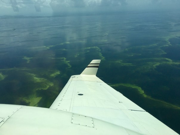


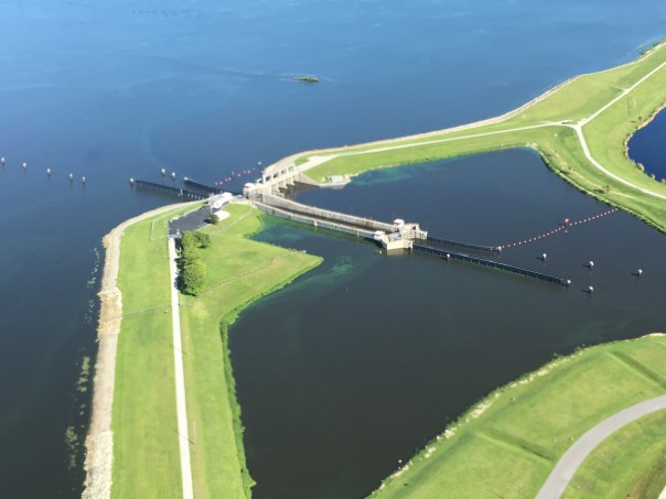


