Today’s blog post is about western Martin County Florida’s Palm City. This post includes my mother’s inspiration, my brother Todd’s time capsule flight video, and my writing.
Palm City was once narrow strips of pine flatlands interspersed with hammocks, ponds, wide prairies, sloughs, sawgrass and cypress trees. Today it is a bustling part of Martin County due to the drainage of the C-23 canal on the north, and the C-44 canal on the south. When one attempts to unravel the long history of drainage of Palm City, it is helpful to think in three connected but separate levels: local, state, and federal.
In 1919 the Palm City Drainage District was created. It was established for a local level as a special drainage district by the Florida Legislature with a lifetime of fifty years. It was primarily created to drain newly established Palm City Farms. Miles of canals and ditches were dug to drain into Bessey Creek, Dansforth Creek, and the South Fork of the St Lucie River. Some of these canals and ditches still exist today or have been incorporated into larger canals.
Digging of the St Lucie Canal in the south began around 1915 lasting into 1926. It was dug by the Everglades Drainage District, State of Florida, from the South Fork of the St Lucie River to Lake Okeechobee. After the deathly hurricane of 1928, the federal government authorized widening and deepening the St Lucie Canal to create the Okeechobee Waterway also known as the Cross State Canal from Stuart, across Lake Okeechobee, to Ft Meyers. Doing so allowed the St Lucie Canal to conveniently function as the main outlet for Lake Okeechobee’s flood waters. Later, after the great flood of 1947, the canal became part of the Central and Southern Florida Plan and renamed C-44 becoming part of the giant Central and Southern Florida Flood Control System of the Army Corp of Engineers.
The great flood of 1947 called not just for the widening and depending of the St Lucie Canal and enlargement of its structures, but the federal Flood Control Act of 1948 authorized more canals, levees, and structures to be built by the Army Corps of Engineers throughout southern and central Florida. Among the new canals were the C-23, the C-24 and C-25 canals of Martin and St Lucie counties -all discharging into the North Fork of the St Lucie River. The state asked for and supported this. The C-23 is the border between Martin and St Lucie Counties. Of course there were major unintended consequences that added to the discharges of the St Lucie Canal and the original Palm City Drainage District. This plethora of fresh, dirty water has all but killed the St Lucie River. Improving the health of the St Lucie is the goal of local, state, and federal restoration efforts today.
-Below: the federal government’s (ACOE) Central and Southern Florida Flood Control Project authorized by Congress in 1948 included C-23 on the border of Martin and St Lucie Counties, C-24, and C-25,- and enlarging the flood control structure along the St Lucie Canal. Once this system was built out it was turned over the state of Florida’s Central and Southern Flood Control District; however, the ACOE kept the St Lucie Canal now named C-44, for federal flood control. The Central and Southern Flood Control District, a Florida state agency that followed the Everglades Drainage District in 1949, became the South Florida Water Management District in 1977. -Below: A 1973 C&SFP update map, Army Corp of Engineers. Green never built thank God!
I posted most of these photos on Facebook, but today I will give explanations and document on my blog. From above, our St Lucie/Indian River Lagoon remains beautiful, but we must be sensitive to the losses beneath the waters. These aerials were taken during a “slack tide” between 12 and 2pm on December 9, 2020 by my husband, Ed Lippisch. December 9th was the last of five days the ACOE stopped discharging from Lake Okeechobee; however S-80 was discharging “local runoff.” (Click on chart above.) Unfortunately, due to high lake level and lack of storage reservoirs, since these aerials were taken, the ACOE has begun ramping up Lake discharges once again.
Below Lawrence Glenn of the South Florid Water Management gives a comprehensive ecological report covering low-salinities and loss of oyster spat in the St Lucie and other aspects, positive and negative, for the entire Everglades system.
Below is an explanation of aerials documenting discharges December 9, 2020. All photos by Ed Lippisch.
-S-80 at St Lucie Locks and Dam discharging local basin S-80 runoff on December 9, 2020
S-308 at Port Mayaca, Lake Okeechobee closed on December 9, 2020. No algae visible.
-Plume of along Jupiter Island south of St Lucie Inlet
-Dispersing plume in Atlantic Ocean just past Peck’s Lake in Jupiter Narrows
-St Lucie Inlet -St Lucie Inlet State Park, Sailfish Point, Sewall’s Point, Stuart, Jensen
-Looking north to Sailfish Flats between Sewall’s Point and Hutchinson Island. This area has greatly degraded since 2013 as far as loss of seagrasses and fishing opportunities
-The area below, especially around Sailfish Point, was once considered “the most biodiverse estuary in North America” as documented, first, by Grant Gilmore
-This photo reveals seagrass loss across many areas of the Sailfish Flats
-Another view between Sewall’s and Sailfish Point, a seeming desert…
-Close up, Sailfish Point
-Sewall’s Point, east Indian River Lagoon
-Sewall’s Point is a peninsula surrounded by the St Lucie River on west side, and Indian River Lagoon on east side
Ed Lippisch, selfie. Thank you Ed!
As you can tell, I have lots of people helping me. Whether it is Ed flying or my brother Todd who provides an incredible easy to read website called EyeonLakeO. You can click below to check it out. The more we know, the more we document, the more we can overturn the destruction of our beloved estuary…
When I saw them I was immediately struck by their shapes. They looked like hundreds of snowflakes lying at the bottom of the mudflats in the Florida Keys’ Tavernier mangrove swamp.
I became preoccupied with them, checking them during different times of day.
“I’ll be there in a few minutes, I’m going to visit those underwater snowflakes.” I told my husband, Ed.
“Are they sea anemones?” I wondered. “Are they some kind of tropical underwater flower?”
I lay prone on the dock, staring. And there I saw it. I saw upside down jellyfish- yes standing on their heads as if they were sleeping. I realized the beautiful geometric shapes, the snowflakes, were their out folded branching tentacles.
How bizarre!
Some of the jellyfish were “breathing,” their heads expanding and contracting, pushing water, while others seemed completely comatose, not moving at all.
A few smaller ones were actually swimming heads-up the way I would expect a jellyfish to!
I took lots of photos while hoping no boat would disturb their slumber.
I read, laughing, when I learned that they are indeed known as Cassiopea, the “upside down jellyfish,” ironically, all part of a symbiotic relationship with algae. (https://en.m.wikipedia.org/wiki/Cassiopea)
I really fell in love with this snowflake jelly forest. Now, before I go to bed, I often wonder what they are dreaming about.
Family friend Scott Kuhns is a great dentist, pilot, and photographer. For years, Scott has been one of our “eyes in the sky,” taking flight over the St Lucie River-Indian River Lagoon -and west out to Lake Okeechobee.
Today, Sunday, May 3, 2020, before noon, Scott forwarded these striking photos. He wrote “I can see some algae at Port Mayaca.”
When I first reviewed the impressive photographs -coast to lake- I found it hard to believe, but indeed looking very closely, there is a wisp of algae close to S-308 at Port Mayaca in Lake Okeechobee.
Can you see it? When things are so beautiful, like right now, it’s easy to miss!
Thanks Scott for your continued service “River Warrior” extraordinaire! We will continue to keep an eye on the water as we move closer to hurricane season.
ST LUCIE INLET, CROSSROADS OF INDIAN AND ST LUCIE RIVERS DIVIDED BY SEWALL’S POINT, ~ALL PHOTOS BY DR SCOTT KUHNS
JUPITER NARROWS & ATLANTIC OCEAN SOUTH OF ST LUCIE INLET
C-44 CANAL at ST LUCIE LOCKS AND DAM, S-80
S-308, CONNECTION OF C-44 CANNAL to LAKE OKEECHOBEE
VERY TIP of S-308 with ALGAE WISPS SLIGHTLY VISIBLE, BUT DEFINITELY THERE
INSIDE STRUCTURE S-308, PORT MAYACA LAKE OKEECHOBEE ALONG C-44 CANAL. S-53 ON ANOTHER CANAL. ALSO FPL COOLING POND SURROUNDED ON WEST BY WHAT APPEARS TO BE SUGARCANE FIELDS
REMNANTS OF THE ORANGE GROVE THAT IS NOW THE C-44 RESERVOIR AND STA.
SLR basins. SFMWD. You can see FPL cooling pond just northeast of S-308.
Even though the water in yesterday’s photo looked gorgeous, lest we forget, here are some images of the St Lucie River/Indian River Lagoon area during a rainy and cyanobacteria ridden 2018.
Ed and I didn’t start taking pictures until were motivated…
You’ll see that after the rain event, the St Lucie River/Indian River Lagoon looks terrible even with out Lake Okeechobee discharges. This is caused by directed water runoff from C-23, C-24, C-25, C-44 and “local” coastal runoff. Naturally, the river never took all this water. Humans made it this way, and we must fix it.
SFWMD canal and basin map.
Soon after the torrential rain, the Army Corp of Engineers made things even worse and started dumping from Lake Okeechobee through the C-44 Canal into the St Lucie River by opening up the gates at S-308 and S-80.
My husband, Ed, first flew over Lake O on June 1st, just by chance. At this time, he spotted algae on the lake and took a photo. Ironically, the next day, the Army Corp started dumping from Lake Okeechobee on June 2nd!
The algae or cyanobacteria (http://www.ucmp.berkeley.edu/bacteria/cyanointro.html)
that was festering in the Lake began to show up almost immediately thereafter in the St Lucie River that has also become a “nutrient porridge.”
After another long, hot summer, the Army Corp finally stopped discharging in the fall~October 5th… Take a look at the photos and remember to enjoy the blue water when it is here, but NEVER FORGET! Only though looking back, will we have the determination to change the future.
Major rain event in March 2018. Rain filled this vile up many times!
SLR IRL following major rain event in March 2018. This is runoff from C-23, C-24, C-25, C-44, and “locally” from developed areas along the river and uplands made to drain into river. JTL
Following rain event in March 2018. A brown Atlantic.
Following rain event in March 2018, the SLR/IRL ~Scott Kuhns
Following rain event in March 2018 Sailfish Flats between Sewall’s and Sailfish Points ~Scott Kuhns
June 5th. A very dark plume moves south along Jupiter Island, just days after ACOE begins dumping so this is a combination of all pollution/runoff waters…
LAKE OKEECHBEE DISCHARGES ADDED
Ed in the Cub after plume photo
Algae as photographed/spotted by Ed in Lake O on June 1st 2018.
City of Stuart, June 9 2018.
Rio near Central Marine, week of June 12, 2018
Photographing a manatee in the algae along seawall by Mary Radabaugh
Mary Radabaugh manages Central Marine with her husband. JTL
Mary found a dead baby manatee floating in the putrid water shortly after LO discharges. MR
LAKE O: Week of June 16th, June 25th, and July 22nd. Cyanobacteria (blue green algae) blooms and then subsides. ~All the while, this water is dumped into the St Lucie River by the Federal Govt.; the water quality is terrible and this the responsibility not of the Feds but of the State of Florida.
Algae is now very visible in Lake O, June 16, 2018 JTL
June 25, 2018 Lake O, near S-308, Port Mayaca. JTL
C-44 canal leading to SLR from Lake O.
C-44 canal leading from LO to SLR.
Satellite view LO bloom on June 24, 2018. ~At its height.
By July 22, 2018 the bloom in the LO is lessening, JTL
August 29, algae would come and go, throughout the SLR. Here near Overlook Drive JTL
September 4, algae still “coming and going” ~2018 Snug Harbor, Stuart. Photo by my uncle, Dale Hudson
October 5, the ACOE stops dumping from Lake O. The blooms stop almost right away but the damage remains….
December 8, 2018 the river looks “normal” again near Sewall’s Point but it is not. JTL
Recently, the Florida House of Representatives announced its committee appointments made by new House Speaker Jose Oliva. Today, I will note those appointed to environmental committees which, of course, function in the dark ages, bound together with agriculture. Advocates should know these key players and build relationships now, and during the committee process that beings January 8, 2019 ~not once Legislative Session begins in March. Too late!
So here we go…
The really all-powerful Speaker of the House is Jose Oliva who will reign from the end of 2018 to 2020. He is from Miami Lakes and is C.E.O. of Oliva Cigar Co. Read about him below and the committees and representatives over which he has great influence. Congratulations to him on attaining this leadership role that very few achieve.
Speaker Oliva’s environmental appointments are below with an article or two giving background on each appointee. Agriculture and Natural Resources Appropriations Subcommittee Chair, Rep. Holly Raschein is from Key Largo and a Health Care Special Projects Manager. Vice-chair, Rep. Rick Roth is from West Palm Beach and his heritage is linked to a multi-generational family-farm in the Everglades Agricultural Area. Holly has a track record supporting environmental issues such as the EAA Reservoir and Rick works for the environment within the goals of the EAA Environmental Protection District and the 1994 Everglades Forever Act. Read below about both representatives and what they have to say.
Interestingly, Holly Raschein also serves on the Subcommittee for Agriculture as and Natural Resources as vice-chair to, chair, Chuck Wesley, a College Administrator from Newberry (near Gainesville). Rep Wesley notes that “sustainable agriculture and the environment are some of his top goals.” You can read what he wrote in an op-ed for below. All this sounds good. But what does that really mean? Our job is to hold all of these politicians accountable.
Yes, it is important we know and communicate with who is in charge. I hope you will reach out to all of them through letter best, but email, or phone call helps too. I wish all my readers a Merry Christmas and Happy Holidays! Thank you for reading my blog in 2019. I’m looking forward to seeing what 2019 will bring…
For more information on Florida House of Representatives go here https://www.myfloridahouse.gov. Look at their calendar, see when committees meet, follow what they are reviewing and call, write their office to let them know how much you love Florida and that water is key!
Sometimes the history of the Everglades is really confusing. Why, with all of the environmental advocacy, since the 1970s, does the health of our environment remain crippled? One way to simplify it is to think in terms of before and after the 1947 U.S. Central and South Florida Plan. Of course there is extensive history before 1947, but it was after 1947 that things in South Florida’s water world became culturalized, compartmentalized, and legally defined. Before we talk about this 1947 Central and South Florida Plan, let’s review some important highlights pre-1947.
1. Hamilton Disston begins the drainage of Lake Okeechobee (1881)
2. Governor Napoleon Broward hires U.S.D.A. scientist James Wright who determines that “eight canals would indeed drain 1,850,000 acres of swampland” (1904)
3. The U.S. Congress’ Rivers and Harbors Act includes significant funds to deepen the manmade Hamilton Disston connection of the Calooshahatchee River to Lake Okeechobee (ca.1910)
4. The scandal of James Wright (from #2 above) who was deemed “a fraud” for the failure of the land to drain as expected ~causing the slump in swampy real estate sales (1914)
5. The resurgence of confidence in sales and a 1920s real estate boom fueled by advances in soil science, and the success of agricultural start-ups located in Moore Haven, Belle Glade, and Clewiston south of Lake Okeechobee
6. Land in a defined “Everglades Drainage District” more fully being systematically cut into sections for development with canals draining agricultural fertilizers and other chemicals into the waters of the state (1924)
6. Two very powerful hurricanes causing thousands of deaths and the destruction of property, and thus the state’s “call for a higher dike” (1926 and 1928)
7. The state’s reaction to the hurricanes, the 1929 establishment of the “Okeechobee Flood Control District” for the “Everglades Drainage District” as well as the Federal Government’s Army Corp of Engineers taking over “field operations”around Lake Okeechobee ~including the building of a thirty-five foot earthen dike and ingeniously using navigation funding to build the cross-state-canal, connecting the Caloosahatchee and the St Lucie Estuaries to Lake Okeechobee ~conveniently working as discharge-escapes through those estuaries when “necessary”
So, as we can see, a lot happened pre-1947, but it was what happened after, were things really changed…
In 1947 it rained and rained, and there were two hurricanes. From Orlando to Florida Bay the agricultural and developed lands, that had been built in drained, once marshy, swampy areas, really flooded, and in some places a foot of water sat for months. There was great economic loss.
The crying cow booklet, above, was sent to every member of the U.S. Congress.
The country as a whole was empowered with its post World War II success and prosperity, and with that same determination, the U.S. Congress came to Florida’s rescue…
To fight Florida’s destructive “flood waters” the 1948 U.S. Congress adopted legislation for the CENTRAL AND SOUTH FLORIDA PROJECT, a twenty year flood plan from Orlando to Florida Bay that included the formal creation and protection of the Everglades Agricultural Area south of Lake O, the Water Conservation Areas, intertwined with thousands of miles of canals and structures to control the once headwaters and River of Grass. HOUSE DOCUMENT 643 – 80TH CONGRESS (00570762xBA9D6)
Next, mirroring the same terminology the United States Government had used (the Central and South Florid Project) the state of Florida created the “Central and South Florida Flood Control District” to manage that CENTRAL and SOUTH FLORIDA PROJECT. A bit confusing huh? A tongue twister. And in a way one could say, at that time, the Central and South Florida Project and the Central and South Florida Flood Control District “became one.” The overall goal above all other things was flood control. And this marriage of the Central and South Florida Project and the Central and South Florida Flood Control District was successful at controlling the waters, but it also killed the natural environment, thus Florida herself.
This embedded cultural philosophy of “flood control only” was challenged in 1972 with the birth of the national environmental movement, and a consciousness that the natural system that supported Florida’s tourism, quality of life, agriculture, not to mention valuable wildlife, was in tremendous decline.
As Florida matured came Governor Claude Kirk, a republican, in 1968, who was advised by environmentalist Nathaniel Reed. Then came Governor Reubin Askew, a democrat. The Florida Legislature, seeing the destruction of the state’s natural resources, passed a very important piece of legislation, the “Florida Water Resources Act,” today’s Chapter 373 in Florida Statures. (http://www.leg.state.fl.us/statutes/index.cfm?App_mode=Display_Statute&URL=0300-0399/0373/0373ContentsIndex.html)
This law created five Florida water management districts with expanded responsibilities for regional water resources management includingenvironmental protection not just flood control.
Accordingly, the Central and South Florida Flood Control District changed its name, but not its heart, becoming the South Florida Water Management District, we know today…(https://www.sfwmd.gov)
Knowing who has been assigned what committees is important. Let’s learn about a couple of “water-senators ” ~those assigned to committees where water will come up. No pun intended.
First, let’s go to the Florida Senate website and click on the Committees Tab. Look around. What titles have something to do with water or the environment? Here you will see a list of committees. Very interesting! Only a few could apply.
For sure, when it comes to purposes of water, under Standing Committees,Appropriations Subcommittee on Agriculture, Environment, and General Government is key.
Who got this position? Wow! Senator Debbie Mayfield has been assigned to be the chair of the Appropriations Subcommittee on Agriculture, Environment, and General Government. She represents Indian River and Brevard Counties and in earlier years served in the Florida House of Representatives so she knows about all the toxic “Lost Summers,” and the troublesome “brown tide” that affects her area.(https://www.floridatoday.com/story/news/local/environment/lagoon/2018/03/02/again-killer-brown-algae-responsible-2016-mass-fish-deaths-blooming/381630002/)
When you click on her name you will also see she serves on the Environment and Natural Resources Committee and the Appropriations Committee. Senator Mayfield is very well versed in water issues not only because she is our Indian River lagoon neighbor, but because as she was an ally of former Senate President Joe Negron in 2018.
Now, take the time now to click on these links below and see if you happen to know any of the other senators serving on either the Appropriations Subcommittee on Agriculture, Environment, and General Government or the Natural Resources Committee or anything else relevant, perhaps Tourism where water really belongs. Take note of these senators. Do you know anyone who may know them? A friend across the state?
Now for one more water senator. He who holds the purse strings! Appropriations Chair, Senator Rob Bradley, another Negron ally from last year. Senator Bradley represents Marion County, a region where there are many nutrient pollution/flow/algae Springs issues and concerns about development and over aquifer withdrawal.(https://www.ocala.com/news/20180114/study-finds-nitrates-not-only-problem-affecting-springs) Bradley is no stranger to water!
Click on his link and see what other committees he is on as well.
There are other important positions, but these two featured Senators that have a track record. These are two you can reach out to now, along with your legislative delegation.
Yes! Start building relationships NOW.
If you can’ reach the legislator him or herself, call, write or go to their office and build a relationship with their staff. Like any relationship this takes time, effort, finesse, and multiple visits. Ask for a meeting just to talk about what is important to you as a citizen, no matter your political affiliation. All Florida politicians represent all Floridians.
Here are some tips about Effective Communication and a visual from last year to refresh our memories about how an idea becomes a law.
Advocate for water now! Once legislative session begins, it’s too late!
My mother gave me a late birthday present: antique post cards and a bottle once filled with “Florida Water,” a popular tonic sold for health and beauty around the world. Believe it or not, “Florida Water” is still selling across the globe, and has been since 1808 ~for 210 years!
It was poignant to receive such a rare and special gift from my mother because if Murray & Landman began marketing Florida water today, the product would not be so romantic; in fact, the branding would more look like war.
“Florida Water,” a thing of the past?
Not if we fight to win.
TCPalm reporter Tyler Treadway holds a container of Florida Water in July 2018, Photo by John Moran
Moon through the giant oak tree at my parents house, 11-6-14. (Photo Jacqui Thurlow-Lippisch)
The death of elderly Mr Nathaniel Reed, was not completely unexpected. He was like an ancient champion oak, old and beautifully weathered. But the news of his death was shocking, bringing tears and heartbreak to the many touched by his long branches, and the seeds he spread along the way.
I can never “not remember” Mr Reed. He was always, since my earliest childhood, a figment of my greater imagination and consciousness, an example of what it meant to have a meaningful life and purpose, to walk and make change in the tainted world of politics, to choose the greater-good over greed, to inspire.
During my Sewall’s Point mayorship in 2011, I first became active in the environmental community for which Martin County is known. Mr Reed planted the seeds, writing me a note here and there, on his quality stationary; in 2016, he gave the maximum amount to my campaign when I ran for county commissioner, District 1, and in his final years, Mr Reed wrote a Letter to the Editor of the Stuart News of which he sent me a copy.
At that time my student proposed Constitution Revision Commission proposal “A Right to a Clean Environment” was getting clobbered by Affiliated Industries, the Florida Chamber, The Florida Agriculture Coalition, and other powers who had assembled a legal team, including a former Florida Chief Justice to squash this threatening idea.
I was so worn down, and had been working so hard. Mr Reed’s letter and support reinvigorated me and the students. And although the proposal did not make the vote, it made smarter people than me on the CRC and throughout the state think, about how our paradise of Florida has become so polluted, and what we can do for change.
Let’s once again read Mr Reed’s words, at the trunk of the fallen champion oak remembering that we are his acorns, or even his resurrection fern…
Thank you Mr Reed. I am forever grateful. We will work towards your legacy.
Letter: Proposed amendment a brave effort to ensure a clean environment
Dec. 8, 2017
Thank you for the Dec. 1 editorial supporting the right to a clean environment!
The “usual suspects” are opposing the constitutional amendment proposed by Jacqui Thurlow-Lippisch, which would receive strong support from the vast majority of Florida voters, just as they quietly opposed Amendment 1.
The fact that the Department of Environmental Protection and the Everglades Foundation have at last identified every polluter in the vast Okeechobee headwaters is an astonishing feat. The sheer number of polluters is mind-boggling.
The failure to enforce the possibly unenforceable standard (best management practices) shines through the research as testament to the carelessness of our state governmental agencies about enforcing strict water quality standards within the watershed.
There is not a lake, river nor estuary in Florida that is not adversely impacted by agricultural pollution.
As one of the authors of the 1973 Clean Water Act, I attempted late in the process to include agricultural pollution in the bill, but the major congressional supporters of the pending bill felt that by adding controls on agricultural pollution the bill would fail.
Now, 54 years later, fertilizer and dairy wastes are the main contributors to the pollution of the waters of our nation. Algal blooms are all too common even on the Great Lakes.
The “usual suspects” may defeat Thurlow-Lippisch’s brave effort, but you are right: The issues won’t go away!
Lefty Durando’s column clearly states the issues involved in the decades-long struggle to protect the Arctic National Wild Life Refuge. Having been there several times as assistant secretary, I have joined a group of well-known environmentalists, Republicans and Democrats urging defeat of the proposal to open the critical habitat of the coast zone to exploratory drilling. I suspect it is a lost cause, but one worth the fight to preserve the “Serengeti of the North”!
LAKE OKEECHOBEE REGULATION SCHEDULE (LORS) http://www.saj.usace.army.mil/Portals/44/docs/h2omgmt/LORSdocs/2008_LORS_WCP_mar2008.pdf
The second she said it, I was at full attention. This past Tuesday, Sanibel-Captiva Conservation Foundation Director, Ms. Rae Ann Wessel, spoke on the Army Corps of Engineers Periodic Scientists Call. In seven years of listening, in seven years of agency and public comment, I had never heard, seriously, and scientifically, someone address South Florida’s greatest taboo.
Ms Wessel said something like this:
Part of the LORS (Lake Okeechobee Release Schedule 2008) addresses “shared adversity.” Lake Okeechobee is approximately 470,000 acres. Would it be possible to put the water the Corps plans to release from the lake over approximately 484,000 acres of crop lands just south of the lake, rather than into estuaries? The Caloosahatchee algae situation is already at its absolute worst…
You could hear a pin drop…
Wessel was recommending options to the Army Corps and stakeholders regarding the ACOE restarting discharges to the estuaries. Since the previous week’s call, due to NOAA images showing 90% of the lake covered in cyanobacteria blooms, and crisis of algae in both estuaries, the Governor and other powerful politicians asked the federal agency to temporarily stop discharges considering all options before discharging, once again.
Just the previous day, before Wessel’s comment, after viewing the putrid algal mess in the Caloosahatchee, Gov. Rick Scott called for a State of Emergency encompassing seven counties.
Some history, earlier this year, the Caloosahatchee was almost begging the South Florida Water Management District and ACOE for water, but was denied. Now the Caloosahatchee is receiving so much water, with algae to boot, that they are experiencing a toxic summer similar to what the St Lucie experienced in 2016. The Caloosahatchee has had it especially tough this year.
The elephant in the room, or perhaps better described as the Tyrannosaurus rex in the room, is that with Lake Okeechobee over 14 feet, and the fact that we are now approaching the most turbulent part of hurricane season, the ACOE “has to start releasing again,” like now! And everybody knows this.
Therefore, Rae Ann was looking for options, for sharing adversity, and this was fair as the Calloosahatchee has bore most of the adversity this year. She wasn’t talking about flooding the cities in the EAA, she was inquiring about flooding the fields, by less than a foot of water that would evaporate quickly at that extension and depth, maybe stressing but not killing the crops. Sugarcane in particular, is a hardy and durable crop for intermittent periods of water.
Shared adversity… Certainly, the estuaries have have their “fair” share…
So why does the ACOEhave to dump to the estuaries? Why is it taboo to talk about flooding the fields? Because although the 2008 LORS talks about shared adversity the EAA is federally protected by an older and more important document.
The ACOE in not a teacher picking favorites, they are the military taking orders from Congress.
First, the Corps would build a levee from northwest Palm Beach County to the south of Dade County along the east coast, thereby preventing flooding fromthe Everglades to the coastal communities. Second, the Corps would modify control facilities and levees around Lake Okeechobee in order to create more water storage, and it would increase the discharge capacity from the lake in order to prevent flooding. Third, the Corps would create three water conservation areas in Palm Beach, Broward and Dade counties for water storage. Fourth, the Corps would construct canals, levees, and pumping stations to protect 700,000 acres of agriculture south of Lake Okeechobee in Palm Beach, Hendry, and Glades counties, known as the Everglades Agricultural Area (EAA). Fifth, the Corps would build canals and water control structures to handle drainage in Dade, Broward, Palm Beach, Martin, and St. Lucie counties.
This bolded section is the key, this is why Rae Ann Wessel’s question rung so loudly in the silence of the ACOE call. For the ACOE, it is “understood,” that no matter the case, even with LORS, and in spite of “shared adversity,” that 700,000 acres of agriculture fields, south of Lake Okeechobee is to be protected from flooding destruction.
But as we all know, nothing lasts forever.
Just like other laws of our great county, some do, indeed over time, become outdated for the times. Things change. Among other issues, in 1950, when the Central and South Flood Project law was structured and voted upon to protect the crops in the EAA as part of flood control 2.81 million people lived in Florida. Today, 20 million people reside here. In the old days, the discharges did not have the impact as they do today, the rivers were healthier, and the Lake, it wasn’t so polluted. But now, seventy years later, water quality, pollution, and human health issues have risen to a point of question. “In emergency situations”, is discharging cyanobacteria water from Lake Okeechobee into the now heavily populated areas along the estuaries to prevent flooding of the Everglades Agricultural Area in the state’s best interest, or is it archaic, like the T-Rex in the room?
It might be time to re-evaluate South Florida’s greatest taboo.
-Above aerials: Caloosahatchee algae bloom 7-6-18, photo courtesy pilot Dave Stone.
I am posting this, not because I want to but because I have to. I much rather be enjoying the day instead of once again sitting at my computer. But time is of the essence.
This morning I read a comment by TcPalm reporter, Ed Killer, on Facebook stating the ACOE’s pulse release schedule for the St Lucie River.
If this is true, and with Ed Killer posting, I believe it is, the ACOE will start releasing again Monday, 6-25-18. I did not know this until I read his post.
Today, my husband Ed and I were flying other people over Florida as usual, and during our flight I took this video expecting maybe some algae in C-44 but instead also found the gigantic bloom against the gates of S-308 in Lake Okeechobee leading into C-44/SLR.
So I wrote on Facebook:
I am so over this, but cannot fail to report. According to Ed Killer ACOE will start discharging from Lake O tomorrow in spite of Governor’s Emergency Order. Look at this algae mess waiting at gates of Port Mayaca. Write ACOE’s LTC Jennifer Reynolds and politely ask for ACOE to wait and to have DEP test again: jennifer.a.reynolds@usace.army.mil (JTL-S-308 video taken 6-24-15 at 12pm) #toxic2018
As Monday is tomorrow, and I fly to DC with the River Kidz tomorrow, I am posting this now. I truly believe considering the circumstances, that the ACOE should refrain from discharging at S-308 or S-80. And the state’s FDEP (Florida Department of Environmental Protection) should have this water tested, again, as bloom has changed.
To just dump this on the people of Martin County along the St Lucie River is a crime.
Respectfully,
Jacqui
PLEASE WATCH THE VIDEO
The recognizable shape of S-308 the entrance to C-44 and the SLR. Lake O’s connection to the river—obvious massive algae bloom at gates.
Bloom as satellites show is throughout and scattered in lake. This shot is looking more towards middle of lake in southern area.
Entrance to Caloosahatchee on west side of lake and near Clewiston Bloom is all through lake.
Since my husband, Ed, accidentally spotted an algae bloom in Lake Okeechobee, while running new engines on the Baron, I have posted many photos on Facebook and the word is out.
Nonetheless, for purposes of documentation, I am going to post some of the photos again on my blog for historical purposes and for those who do not use Facebook.
~Ed noticed the “lines of algae” in the lake on June 2, two miles or so northwest of Port Mayaca, the day after the ACOE started discharging from Lake O into the St Lucie River. Absolute chance, fate, or a tip from above, however you decide to look at it.
Since this time others have documented on the ground and DEP should be testing for toxicity.
So, after seeing the bloom on Friday, Ed went back the following day on Saturday in windy conditions so I stayed home–in the yellow plane, the Cub, getting more pictures of bloom, looking about the same but more dispersed from rain perhaps. These photos at lower altitude also include drainage structures around the lake, as well as the destruction of the St Lucie River/Indian River Lagoon at Sewall’s Point and the St Lucie Inlet.
Photos will continue to be taken as we once again, document the discharges, and once again have seen first-hand, like we did in 2016, without the warning of our government, that the algae that contaminates the St Lucie River starts in Lake Okeechobee.
I am looking up at an absolutely blue and cloudless sky; white, sparkling sands are hot beneath my feet; and crashing waves of emerald green, mesmerize…
Blue. White. Green. This is all there is. This is the vision, the dream. And it is real. These are my memories of living at Pensacola Beach.
More than twenty years later, I am not dreaming. I am back, and I am fighting for CRC proposal 91, “no oil or gas drilling in Florida’s territorial seas,” our state waters.
In the early 1990s, I came to Pensacola from UF in Gainesville, to teach German and English at Pensacola High School in both the traditional and International Baccalaureate Program.
I learned perhaps as much as my students. It was hard and rewarding work. I matured here one could say.
Maturing didn’t just involve the discipline of being a teacher, but also the responsibility of my first dog. “Dash,” as he was named for his ability to sprint. Dash was a stray I found in Downtown’s Seville Square. He was as beautiful and white as Pensacola Beach with black spots over his eyes. Even my parents visited to meet him!
Every evening he sat by my side for hours as I graded papers long into night. I would leave at 6 am for the first bell at 7:01. When I got home from a day of teaching, Dash and I would swim at Pensacola Beach or take long walks to Fort Pickens and then of course, grade papers,
These were wonderful times! The powerful simplicity of the blue sky, the green waves, the white sands, and my white and black best friend, forever left an impression on me.
This photo of a panther in Sebring was recently shared by a friend. I do hope this magnificent creature has visited western Martin County. Since late October, it has certainly made the rounds. Males roam hundreds of miles, a female less, but easily could cover ground between almost neighboring Martin and Highlands counties.
Can you imagine trying to navigate today’s world? Freeways, subdivisions, fences, shopping malls, the great forests gone…Canals cutting the lands and watersheds apart?
Over 34 panthers were killed on Florida highways in 2016, and at least 23 in 2017. With an estimated 230 in the total population, those are terrible numbers. We must work harder to complete wildlife corridors across the state to allow these animals to breed and travel into north Florida and Georgia. Being stuck in South Florida is a radio-collared death wish.
If this panther does visit Martin County, we’ll probably never know it; though large they are smart to be very, very, shy.
I must say, lately I’ve been hearing rumors of panthers (yes, a pair) in Martin County near Highway 96 out by South Fork, but no photos yet…
Thank God there is something left to run wild in the world; 😊 it gives me something to dream about.
Last night’s twilight flight was a first for me, but not for my husband Ed. Usually, we fly in daylight chasing algae blooms or black Lake Okeechobee water…
Last night was just for fun, but one still feels the pull to protect this sacred place.
The beauty of the lands lighting up beneath us was almost as inspiring as the sunset. Humanity, such promise.
We do live in a beautiful place. A place to protect and call home…
Growing up in Stuart in the 1970s, my mother and father gave me full reign to explore the undeveloped lands in the area of St Lucie Estates. I remember endless summers, wandering around in “the woods” and of course my eyes were drawn to the vine of the widely dispersed, perfectly shaped, red and black seeds known as rosary peas.
I would collect them tightly in my little, sweaty hands, pushing them far down into my pockets. I recall the first time I brought them home, my mother said, “Yes, they are very pretty, but don’t eat them, they are poisonous.”
“Hmmm,”I thought. “How can something beautiful be poisonous?”
I continued to collect the seeds, and over the years filled up many clear glass bottles that sat in my window sill; the sun never fading their brilliant color.
Later in life, I learned that bright color patterns, especially red, black, and yellow, as with some caterpillars, or the famous, shy, and deadly coral snake, are “warnings” in nature and actually provide the animal with protection from being eaten.
As I walk through Hawk’s Bluff today, I am thankful to my parents who allowed me to explore the natural world and grow confident, unafraid, even with all of its toxic beauty.
I was appointed to the Constitution Revision Commission, that meets only once every 20 years, last February, by Senate President Joe Negron (https://www.flcrc.gov). After a dizzying time, I’d say, I feel like I am finally catching my stride. The entire experience has been a lot like when I moved to Berlin, Germany in 1989. It was cold and I did not speak the language, but after many months of study and applying myself, it started to feel natural.
I have learned the CRC history; mastered the insane elevator system at the Capitol; gotten insight into the complexities of power and politics; met people from all over the state with their own serious issues; recognized the incredible importance of staff and of journalists; have learned how to run an effective legislative-style meeting; and how to stand my ground on a vote.
I have tried to apply the “5-Cs” that an army general taught me years ago…. Communication, Collaboration, Compromise, Cooperation, and Consensus…
As you may know, I sponsored 5 CRC environmental proposals. These came from the public’s submittals on-line, or from a public hearing earlier last year. One was a former citizen’s initiative. Today I will review where I am and where I think things are going.
The proposal that has gotten the most attention as well as the most push back–with 4 AIF hired Gunster lawyers, one a former Supreme Court Justice, fighting tooth and nail—has been P23, “A Right to Clean and Healthful Environment.” It was workshopped and heard by the Judicial Committee and I expect it to be voted on Friday, January 12, 2018. Due to the controversy, the prognosis does not look good, but it has raised environmental awareness for all of the proposals, and in my opinion made the business and government community look desperate to hold on to Florida’s “standard environmental operating procedure” that puts corporations and development before people. This power will not last forever, and we are all dependent on Florida’s good nature for our “riches.” —A search will pull up a multitude of editorials, news articles, and opinions, on this subject.
Two others will also be heard this coming week. P24 “Commissioner Environmental Protection”and P48 “FWC/Wildlife Corridors.” Both of these will be discussed and voted on by the Executive Committee of which I happen to sit on. P48 would allow FWC to protect habitat not just species. This seems a no brainer as how can you have species without protecting their habitat; but private property and development rights play into the equation so it will be a fight. I look forward to the discussion and for all of us to realize that one way or another, the only way to approach Florida’s growth filled future is with the pragmatic goal of statewide living wildlife corridors, connected and protected lands.
P24 would establish a Commissioner of Environmental Protection. A cabinet position. Just like Agriculture. Since the environment is linked to our number one state income generator–tourism it seems the time has come….challenging power structures is always a wrestling match, but this is one we can win.
The following week, on January 18, I expect to go before the Legislative Committee for P46, “Clarifying Language in Amendment 1 2014, or Land Acquisition Trust Fund.” It was heard once already but “temporarily postponed” to requests by committee and myself to work on the language. Sue Mullins and Clay Henderson are backbone of this proposal, know the background, etc., and I am fortunate to have their expertise.
And finally…
I expect on January 19 to go before the Declaration of Rights Committee for P91,”No gas and oil drilling in Florida’s territorial waters.”
P91 is the only one of the five proposals to have “passed committee” in December. What is so amazing to me about this proposal is its timeliness. When I took it on, I actually first thought to myself, “You know, isn’t this kind of pase’? The River Kidz were protesting oil drilling with Surfrider Foundation in 2012. This won’t happen here…” But because it was past citizens’ initiative, and the language had already been reviewed, and because Manley Fuller who is a legend in the environmental community and the president of the Florida Wildlife Federation brought it to my attention, recommending I support it, I submitted the proposal three minutes before the deadline.
Now many months have passed and things have quickly changed. As headlines explode with oil drilling and federal opening of submerged lands including Floirda’s…it seems serendipitous that this proposal is lined up for the CRC, every Florida politician — regardless of party affiliation, and the diverse citizens of the state of Florida to support.
Some people would call it a “God-wink;” I like to think so. I will fight for every proposal, but it sure is nice to feel the wind at my back.
Rainbow over the Atlantic Ocean. (Jensen Beach, 2-8-15, Jacqui Thurlow-Lippisch)
Tallahassee is a beautiful place. Having spent more time there recently, I have grown to appreciate it. Sometimes, in the early morning, as the sun is rising over the hills, I envision Apalachee warriors and families approaching “Anhaica,” their capital. There is a lot of sacred ground here…
Today, I will summarize week 12-11-17. For me, there were battles won, and cease-fires. And the war for Florida’s environment will continue. Thank you to all who wrote members of committees in support in the previous weeks!
St Lucie River/Indian River Lagoon. Photo Jenny Flaugh.
On Tuesday, December 12th, I presented proposal P23, ” A Right to a Clean and Healthful Environment,” to the Judicial Committee (https://www.flcrc.gov/Committees/JU/). I am proud to say P23 has caused a stir, is making people think, and generating tremendous resistance from the “entrenched-status-quo-power” of the government and business communities as it would give every-day Floridians more standing in court for a clean environment. Power would shift to the judicial, rather than the executive and legislative branches of government, and some agencies would be no longer be “puppets.”
The presentation went well, however, based on comments from many members of the committee, and feedback, I felt the vote would not pass. I was offered a “TP” or “temporary postponement” in order to work on the language as I had not been successful at this —with the opposition —-who refused to do so the previous two weeks. They want “no part of P23 in the constitution.”
Unlike local government, where a commission or council can adjust the language of an ordinance during the meeting, this cannot occur during a CRC committee meeting, so the only way to achieve such is to “postpone” and “work on” prior to the next meeting— and try again. (Very inefficient)…
So, I look forward to working on the language, but I am concerned that ameliorating the language to an acceptable point for the opposition will be so far away from the spirit of the original proposal it may not be recognizable or effective. This would not be good.
In the end, it will be the students of Stetson and Barry Universities and their professors who created P23, a totally public proposal, who will give me final direction.
P23 will go before the Judicial Committee again when called. Chances are this will be in January 2018. It could pass; it could die; it could be withdrawn. Should it pass, it will have to go also to the General Provisions committee, and then to the full CRC for a final vote to go to ballot.
The greatest aspect of P23 is working with young people who are our future generation of leaders because as the proposal states: “the natural resources of the state are the legacy of present and future generations…”
On Wednesday, 12-13-17, I presented P46, to the Legislative Committee (https://www.flcrc.gov/Committees/LE/) to “Clarity Language in Article X, Section 28, of the Florida Constitution, Land Acquisition Trust Fund.” Ms. Sue Mullins, who came to my attention through Stuart’s Joan Bausch and the Native Plant Society, was very helpful and knowledgeable and assisted during the presentation. Again, the proposal was “TP-ed” as Chair Pepe Diaz and others such as former Senate President, Tom Lee said they could not support P46 as written and recommended working together on the language. I am confident they meant this, and we shall try between now and when the committee meets again in January. Their concerns are funding requirements, appropriations, of the state legislature; and our concern is the Legislature ignoring a 2014 citizen initiative that passed by 75% for land conservation. P46 too must go to General Provisions should it pass, and then to the whole CRC for a vote to possibly go on ballot.
OILED SCARLET IBIS – Lindsay Carr Created in response to the BP Gulf Oil Spill and auctioned off in support of the clean up operation. In the style of John James Audubon.
On Thursday, 12-14-17, I presented P91 “No Oil or Gas Drilling in Florida’s Territorial Waters.” This was an interesting experience as I was presenting to the committee I chair, General Provisions. (https://www.flcrc.gov/Committees/GP/)
As a presenter, I am just like anybody else.
Mr David R. Mica, Executive Director of the Florida Petroleum Council, AIF, and other business interests spoke against, but fortunately, Mr Manley Fuller, president of the Florida Wildlife Federation, the Sierra Club, and citizens spoke “for,” and were quite convincing. There were even two young children in the audience rooting me on! I was very pleased when the committee voted 5 to 2 in favor of P91! P91 will now go to the Declaration of Rights Committee (https://www.flcrc.gov/Committees/DR/) in January, and then if passes, again, to the full commission to possibly go on 2018 ballot.
12-4-17, ca. 2:45 pm, photos: Ed Lippisch & Jacqui Thurlow-Lippisch
The Army Corp of Engineers has lessened but not stopped Lake O discharges that started September 20th, 2017 just prior to Hurricane Irma. Perhaps as the discharges have gone on at such a high rate for a comparatively long time, the plume has had a chance to extend its territory. In yesterday’s photos, the dark, filthy plume is reaching clearly south beyond the exclusive Town of Jupiter Island.
Yesterday was a beautiful day, but the river and ocean waters of our entire region were ugly, possibly contaminated. How are we to enjoy our property and lives here?
When viewing the aerials below, please note the blue, sapphire-colored water just on the edge of the discharge plume. Yes, of course all estuaries put forth darkened fresh water after a rain event, and Ed and I could see this occurring just south at Jupiter Inlet. Nonetheless, the black, gigantic plume that we repeatedly endure for the St Lucie River/Indian River Lagoon due to discharges from Lake Okeechobee is an aberration.
Please let’s all support Joe Negron and the public’s work to build the EAA Reservoir; clean & send the water south!
Dear Fellow Commissioners, and Citizens of the Great State of Florida:
As many of you know, I firmly believe our quality of life as citizens and our state’s economic vitality greatly relies on the protection and preservation of our environment.
As we begin our important work of examining proposals in committee, I wanted to share additional information about the following five proposals I have sponsored to protect Florida’s natural treasures for future generations.
St Lucie River/Indian River Lagoon (Photo Jenny Flaugh)
1) Proposal 23: At the basis of my environmental protection argument, I believe above all Floridians should have a constitutional right to a clean and healthful environment. Read more about this proposal at the following link: https://t.co/JZiYwr0kMf. I also recently authored an OpEd on this topic in TCPalm at the following link: http://bit.ly/2zSqrl9.
2) Proposal 24: I propose an elected “Commissioner of Environmental Protection” who will have supervision regarding matters pertaining to environmental protection that the Department of Environmental Protection and the Water Management Districts are authorized to implement and administer. Read more about this proposal at the following link: https://t.co/D5lEgRFxNe.
3) Proposal 46: This proposal would help clarify how funds are deposited into the Land Acquisition Trust Fund. Read more about this proposal at the following link: https://t.co/x37BxRu2sj.
Sightseeing Miami
4) Proposal 48: This proposal would give the Florida Fish and Wildlife Commission authority to establish rules limiting impacts to habitat, and wildlife corridors, in the same way they currently establish limits on impacts to individual animals. Read more about this proposal at the following link: https://t.co/5Gh4BfPfIY.
A bird covered in oil after the Deep Water Horizon explosion, 2010. Photo courtesy of Associated Press.
5) Proposal 91: This proposal would prohibit oil and gas drilling in Florida territorial waters. Read more about this proposal at the following link: https://t.co/IkCCIdd4Wj.
The ongoing debate over the deterioration of our environment should not be about politics. Rather, it should be grounded in the welfare of our natural resources, our wildlife, and the citizens of our great state.
It is an honor to serve as a CRC commissioner. Please contact me if you would like more information or have questions and thank you.
Sincerely,
Jacqui Thurlow-Lippisch
Commissioner, & Chair, General Provisions
Constitution Revision Commission 2017/18
The Process:
These proposals will be, or have been referred to a committee, or multiple committees. If they “get through committee,” and are supported later in early 2018 during the final public hearings, they will be voted on by the full CRC to go, or not to go, on the 2018 ballot. You can support or communicate concerns regarding these proposals by going to the CRC website above and writing the commissioners. If you are really determined you can go to the Committee tab and look at what each committee has before it and narrow it down when you write commissioners. You really have to check the website daily to follow. Anything you can do is appreciated; we are a better state when we all make an effort to be part of the process.
Last Thursday on November 16, the ACOE reported they will reduce the amount of water they are releasing from Lake Okeechobee. The Corp had been releasing at a high rate, on and off, since September 20th. New targets are 2800 cfs east and 6500 cfs west.
Photos below were taken yesterday, 11-19-17 by my husband, Ed Lippisch. We will continue to document the discharges from Lake O, and area canals.
As Thanksgiving approaches, we are thankful the discharges are lessened and that the SFWMD and the public are working hard to plan the EAA Reservoir Senator Negron fought for… We the people of Martin County, will not be satisfied until these discharge stop. The river has its hands full with unfiltered discharges draining agriculture and developed lands from C-23, C-24, C-25 and C-44. All must be addressed.
“And where the river goes, every living creature that swarms will live, and there will be very many fish. For this water goes there that the waters of the sea may become fresh; so everything will live where the river goes…” Ezekiel
St Lucie Inlet, Sailfish Point R, Jupiter Island L, and Sewall’s Point and mainland Stuart in distance.
Sewall’s Point
Manatee Pocket
Hell’ s Gate Sewall’s Point to right
C-23 main SLR
Confluence of SLR/IRL at Sewall’s Point’s southern tip
Sewall’s Point
IRL looking towards Sewall’s Point and Stuart. Incoming tide pushes plume waters north into IRL
somewhere looking down…
SFWMD canal and basin map. C-44 canal is the canal most southerly in the image and was connected to Lake O in 1923. C-23, C-24 and C-25 were built later in the 50s as part of the Central and South Florida Project that over-drianed South Florida causing many of the water problems we live with today.
Atlantic ocean off Jupiter Island, plume water moving south over nearshore reefs
IRL near Sailfish Flats where seagrass forests used to flourish housing many fish…
Everyone has heard the story….Florida voted 75% in favor the 2014’s citizen’s initiative, “Amendment 1,” and once it was in the constitution, the hard-earned constitutional amendment was “ignored” or “reinterpreted” by the state legislature…
In 2015 the Tampa Bay Times wrote: “Few betrayals of the public trust have played out so openly and brazenly as the Florida Legislature’s fraudulent effort to implement Amendment 1, the land-buying measure that three-fourths of voters overwhelmingly approved five months ago. This should be a banner year for protecting the state’s endangered lands. Instead, Amendment 1 is becoming a bait-and-switch that would take Florida back — not forward — in saving its natural resources.” (http://www.tampabay.com/opinion/editorials/editorial-legislators-ignore-voter-intent-on-amendment-1/2227235)
As a commissioner for the Constitution Revision Commission for 2017/18, (http://flcrc.gov) I have sponsored proposal #46 to help fix this issue. Brought to my attention by long time Martin County Native Plant Society member, Mrs Joan Baush, and crafted together with policy advisor, Sue Mullins, and environmental legend, Clay Henderson, this proposal follows at least seven others submitted to the CRC on the subject, not to mention the numerous requests of multiple speakers during the Constitutional Revision Commissions’ statewide public hearings.
The purpose of proposal #46 (originally public proposal #700705) is to “clarify that a percentage of doc-stamp tax revenues will be devoted to the purchase and care of scientifically selected and publicly supported land and water areas for the purposes of conservation.” An explanation, and the proposal are below. To support, please write members of the Legislative Committee, where this will first be heard: http://flcrc.gov/Committees/LE/
The CRC comes around only every 20 years, and is one of five ways Florida can amend its constitution; thus the time is now! Let’s get this clarified!
Land Acquisition Trust Fund Amendment
Section 28, Article X
Explanation
Purpose
This proposed Amendment to S. 28, ART. X is to clarify that a percentage of doc stamp tax revenues will be devoted to the purchase and care of scientifically selected and publicly supported land and water areas for the purposes of conservation.
Background
On November 4, 2014, Florida voters approved the Florida Land and Water Conservation Amendment 1 by 75%.
But the 2015 Legislature determined that the broadness of the measure already allowed them to spend the earmarked revenue of a wide array of programs through the Land Acquisition Trust Fund—some not at all environmental in substance—as well as supplant existing agency operations funding with the “new” Amendment 1 dollars.
The measure was designed to dedicate 33 percent of net revenue from the existing excise tax on documents to the Land Acquisition Trust Fund, where it was assumed its namesake Land Acquisition Trust Fund would denote the purpose and intent of the amendment to acquire and manage environmentally sensitive land.
Because the drafters of Amendment 1 used the Land Acquisition Trust Fund as the receiving account (thinking it would be obvious the intent for the use of funds), without specifying an amount strictly dedicated to land acquisition, they allowed for all expenditures provided in s.375.041, F.S. governing use of funds for the LATF, which at the time, allowed for virtually anything the Legislature wanted to fund.
Once the measure passed by an overwhelming 75% of the Florida electorate, supporters assumed that at least $300 million annually would be devoted to the Florida Forever program. The amount, over 20 years, was thought to finish the job of securing the lands necessary to protect our natural resources, drinking water, habitat and industries such as agriculture and tourism.
That did not happen (see below.).
What this Amendment Does
The intent of this new Land Acquisition Trust Fund Amendment to S. 28, ART. X is to clarify that a percentage of doc stamp tax revenues will be deposited into the Florida Forever Trust Fund to purchase and care for scientifically selected and publicly supported land and water areas for the purposes of conservation.
The proposal simply amends language passed in 2014 as the Land and Water Legacy Amendment 1 by depositing the earmarked funds in an appropriate Trust Fund and clarifying the purposes for use of those funds.
A specified amount, no less than one third of the revenue deposited into the Land Acquisition Trust Fund, is earmarked for deposit into the Florida Forever Trust Fund as it existed in law on January 1, 2017.
This language recognizes that the LATF and other doc stamp-funded accounts should continue to have a suitable amount of revenue to support existing programs such as Springs and Everglades protection, beaches, and local government water projects.
More specificity has been provided in the new amendment by striking the phrase “and improvement” to ensure that Florida Forever funds are spent per the science-based regimen contained within statute (s. 259.105, F.S.), and by adding the phrase “natural” to the type of resources authorized for expenditure.
This Florida Forever Amendment will fix the issue to provide funding to accomplish a majority of Florida’s conservation work through dedicating a set amount each year (depending on revenue, from $175 to $300 million) to be spent according to current statute governing the proven, science-based, willing-seller Florida Forever program.
Implementation of Original Amendment 1
In 2014, a broad coalition of environmental, business and civic leaders proposed the Florida Water and Land Conservation Initiative, which became Amendment 1 to the Florida Constitution. The intent was to recapture the annual amount of funds devoted to land conservation by earmarking a third of the revenue from the doc stamp tax and depositing it into the Land Acquisition TF for the purposes of buying, managing and restoring environmental lands. The measure passed by 75% of voters.
But the Legislature interpreted and appropriated Amendment 1 spending to include agency salaries, IT, risk management insurance, agency vehicles and other non-conservation uses.
The statute has also since been amended to accommodate implementation, per legislative judgement of Amendment 1, to include dedicated funds for Everglades restoration, Springs protection and spending on a broad array of programs and agency expenses.
Historical Context
Florida had a long and distinguished history of scientifically targeting and purchasing the right lands for conservation and recreation purposes since the 1970s, throughout both Republican (Martinez, Bush, Crist) and Democratic (Graham, Chiles) administrations.
Those lands today provide most of the natural resources to support our drinking water supplies, food crops, economic activities and attractive recreational destinations.
The annual funds devoted to Florida Forever had been $300 million, usually issued in bonds paid back by revenue from the documentary stamp tax. Creators of the land programs specifically used the doc stamp tax for its revenue source in order to tie land acquisition to sales in real estate, since all land sales in Florida were assessed a documentary stamp tax.
In 2008, the Legislature discontinued funding for the state’s land conservation program, Florida Forever, citing a poor economy.
Once the economic recovery took hold in Florida, where the state economy in 2013 led the nation in job growth and overall recovery (per University of Central Florida economist Sean Snaith in his first quarter economic forecast on March 25, 2014), it was assumed that the state conservation program funds would be replenished.
Since 2010, the Legislature has declined to fund the non-regulatory approach to environmental protection through land acquisition. Funding for the Florida Forever program has not been reinstated.
The Florida Forever program is hugely successful and is the most often-copied land conservation program in the country. It is based on a scientific analysis of which lands in Florida hold the most natural resource value—those that help cleanse water or purify air, create habitat for fish and wildlife, create corridors for the movement of native plants and animals across the landscape and support the water and wildlife necessary to keep our agricultural, tourism and quality of life intact.
Under its conservation programs, the state has protected almost 5 million of its 37.5 million acres. Together with federal conservation lands, almost 9 million acres is in some form of public management, although thousands of those acres belong to the state corrections and management services agencies, military bases and universities, and are not managed for conservation.
The state has identified an additional 2.2 million acres that should be conserved in some form from conversion to more intensive uses. That doesn’t always necessitate outright full-fee purchase of the property, but could be accomplished using a combination of purchase and conservation easements across large corridors of working lands such as ranches to provide habitat and water resource protection.
Expected Support
Dozens of speakers addressing the Constitution Revision Commission during its public hearings voiced their frustration and disappointment with the Legislature’s use of Amendment 1 funds, and appealed for a fix to the issue to accommodate their intent to fund the land acquisition program.
This new Land Acquisition Trust Fund Amendment is likely to pass by at least 75% of the electorate, even with paid opposition. Previous polls taken by the Florida Chamber have shown 78% support statewide, despite opposition from various anti-conservation groups.
Virtually all news outlets endorsed 2014 Amendment 1 and are already writing of their support for a fix that will finally codify the will of Florida voters.
Some counties, including Broward, Palm Beach and St. Lucie, voted more than 80% in support of Amendment 1. Even inland rural counties supported the measure by a vote of at least 40% in support (see map at beginning of this post.)
*This proposal was schedule to go before the Legislative Committee on 11-29-17 but has been postponed. Chances are it will go through in December. It must clear Legislative and General Provisions. You can write members of these committees to support or express concerns at any time: http://flcrc.gov/Committees
A new day could dawn for Florida, should Constitution Revision Commission proposal #24 go on the 2018 ballot. This ballot initiative would allow the electorate to vote for a “Commissioner of Environmental Protection.”
I sponsored this idea, an idea brought to the CRC’s attention by two speakers during the public hearing process, as well as by public proposal #700012, submitted by Mr. Gamez.
Formally expressed Proposal #24 reads:
“A proposal to amend Sections 3 and 4 of Article IV and create a new section in Article XII of the State Constitution to establish the office of Commissioner of Environmental Protection as a statewide elected officer, to provide duties of the commissioner, and to include the commissioner as a member of the Cabinet.”
Why do I support this idea? Because it is my job as a commissioner to get some of the thousands of public ideas before the CRC, and because I believe the “time is now” for the Environment to have a seat at the table with other cabinet positions.
Yes, environmental protection of natural resources must rise to the top of state priorities just as the state’s oldest and number two economic driver, agriculture, has. Our Natural Resources must be represented in the Florida Cabinet. This year, the Florida Chamber reports that Florida’s population, now at 20,000,000 will reach 26,000,000 by 2030, in just twelve years! It is tourism that is Florida’s number one economic driver. Much of this success is based on the beauty and quality of our beaches, rivers, and springs, and natural lands. We all know, growing incidences of algae blooms in lakes, springs, and rivers, some in areas of natural lands, is not good for tourism.
Let’s look at Florida government’s present hierarchy having to do with natural resources and discuss why it should be changed. The state’s present organizational chart shows a Commissioner of Agriculture as a cabinet position just under and to the right the Governor; a Fish and Wildlife Commission, and a Department of Environmental Protection, as executive agencies under the executive branch of the Governor; and the Water Management Districts in the lowest tier as local government. Interestingly, the Water Management Districts are attached by a dotted line to the Department of Environmental Protection noting at “unique relationship.” This is qualified by the following sentence: “Water management districts have individual governing boards but the Department of Environmental Protection may exercise general supervisory authority over water management districts (s. 373.026(7), Florida Statutes).”
The Fish and Wildlife Commission much more independent, but the Water Management Districts are not. Because Water Management Districts levy taxes from citizens as a special district one must be cognizant so that they not become “arm of the state.” But what would be even worse would be if the Water Management Districts were not answering to the people they tax…
Hmmmm?
It is time to have a “lead agency.” An agency that can answer to the people.
Let’s discuss leadership. Right now there is no clear environmental protection leader. For instance, in my opinion, for a citizen trying to get answers about why our environment is falling apart the Water Management Districts are pointing in one direction; the Department of Water Quality for the Commissioner of Agriculture’s Best Management Practices is pointing in another; and because the present Department of Environmental Protection is at the whim of politics of every new administration; they are weak, and afraid to lead. With every new governor the pendulum swings. The DEP is unable to fulfill its mission as the state’s lead agency of environmental protection.
And all the while our environment keeps falling apart…
On a personal note, for years, here in South Florida, I complained about the demise of our St Lucie River/Indian River Lagoon and surrounding environment and pushed for more action on behalf of the South Florida Water Management District. After years of head nods, I was finally told by a Governing Board member that the District’s number one priority is not water quality, but flood control and that I should be speaking to DEP.
“Why didn’t you tell me that earlier,” I exclaimed.
When I contacted Department of Environmental Protection their response was lackadaisical noting that many entities of the state oversee water quality and environmental issues. For instance, Best Management Practices for Agriculture, and the complicated DEP Basin Management Action Plans/Total Maximal Daily Loads in coordination with the Water Management Districts, and all local governments including cities, counties, villages…
“But who is in charge?” I asked? “The St Lucie River has been labeled “impaired” by your agency since 2002. Why was it allowed to get that bad in the first place and why is it continuing to get worse?”
Again I asked, ” Who is in charge?”
There was silence…
I thought to myself, “No wonder the Department of Environmental Protection is sometimes referred to as the agency of “Don’t Expect Protection.” No wonder every year more of the state’s waters are reported as “impaired.” No wonder D.E.P., Agriculture, and the Water Districts collude to extend the Basin Management Action Plan deadlines instead of getting more serious about the detrimental ramifications of non-point pollution for the people.
Enough is enough. The time is now to give voters the opportunity to vote for a Commissioner of Environmental Protection and finally have a seat at the table.
This homemade chart shows a Commissioner of Environmental Protection being created from the present Dept. of En. Pro.
Proposal #24
 The commissioner of environmental protection shall have
   63  supervision of matters pertaining to environmental protection
   64  that the Department of Environmental Protection or its successor
   65  agency and water management districts are required or authorized
   66  by law to implement and administer.
Jacqui Thurlow-Lippisch is a commissioner on the 2017/18 Constitution Revision Commissioner; *this proposal will go before the Executive Committee sometime in December or January. If it gets through that committee it will have to make it through both General Provisions and Ethics and Elections. You can support or voice concerns about this proposal by first writing the Executive here: https://flcrc.gov/Committees/EX/
Recent pictures of our Florida environment that are NOT good for tourist!
Alan Youngblood, Florida Springs, -when too much water is taken from the aquifer by permitted users it affects the health of Florida’s springs, 2013.
St Lucie River, toxic algae bloom brought into river from discharges from Lake Okeechobee. Best Management Practices and Basin Management Action Plans are not working fast enough. Tourism suffered in Martin County by millions of dollars in lost revenue and health issues for local citizens. 2016, JTL
Algae pouring in from Lake Okeechobee to St Lucie River at S-80—this water comes mostly from polluted Central Florida waters; obviously DEP’s environmental protection is not working. 2016.
In 1998 the Constitutional Revision Commission proposed a rewrite of Article IV, Section IV of the Florida Constitution that reduced the Florida Cabinet from six elected officials to three. Effective January 7, 2003, the Florida Cabinet consists of the Attorney General, the Chief Financial Officer and the Commissioner of Agriculture. The Cabinet offices of Secretary of State and Commissioner of Education became appointed offices and their respective agencies became the responsibility of the Governor. The revised constitution also created a new State Board of Education with seven members appointed by the Governor to oversee the Department of Education. The Cabinet offices of Treasurer and Comptroller were merged into the new position of Chief Financial Officer who serves as agency head for the newly created Department of Financial Services.
Without documentation, there is no record. With no record, there is less chance for improvement.
Yesterday, Ed, Luna, Bo and I continued to document the discharges, right now, coming mostly from Lake Okeechobee.
There are serious signs of stress in the estuary including reports of leisoned fish that I have posted on Facebook. The rest, from above, we can see for ourselves…
“Keep the pressure on” for the reservoir and for replumbing the great state of Florida.
It is amazing to realize how much of the Florida Constitution ensures protections of the environment, and yet we see the continued degradation of the natural resources of our state. It’s time we learn our constitution by heart, make sure it’s followed, and take action to see if something need be added.
Today, I am going to list the areas of the constitution that have to do with the environment for easy reference. You can click the links below to see the full amendments.
In 1968, “ardent environmentalist” and respected state representative, John Robert Middlemas, of Panama City, insisted that words of support for environmental policy were placed in the historic constitutional revision that same year.
In his honor, I ask that all fellow environmentalists review below, and ask oneself how to make these words take on a new sense of urgency as our springs, rivers, and natural lands need our voice. At the end of this article, and after reviewing our state constitution, if so inspired, please feel free to enter your own constitutional proposal or improve one that’s simply being ignored.
The CRC is considering September 22nd as the deadline for public proposals so please submit soon!
As an aside, it is my honor to serve as the Chair of the CRC’s General Provisions Committee, which is charged with examining Article II of the Florida Constitution. If you have comments or thoughts regarding Article II (or other provisions relating to the environment), please email me at Jacqui.Lippisch@flcrc.gov.
Here is the list of current environmental provisions in the Florida Constitution:
General Provisions (Article II): Section 7, Natural Resources & Scenic Beauty/Everglades Agricultural Area
Miscellaneous (Article X): Section 11, sovereignty lands; Section 16, limiting marine net fishing; Section 17, Everglades Trust Fund; Section 18, disposition of conservation lands; Section 28, Land Acquisition Trust Fund, (Florida Water and Land Conservation Initiative, 2014.)
To enter your own proposal or idea regarding the environment:
Adams Ranch, Bud Adams/Photographer
Go to gov/Proposals/Submit to create a free account and submit your proposed change to the Florida constitution. The online tool allows you to create your proposal using legal language by redacting or adding language. Remember to keep it simple and clear.
Using the same program, submit your proposal to the Constitution Revision Commission and sign up for the alert emails. Commissioners will review proposals and determine which proposals should be placed on Florida’s 2018 General Election ballot.
You can advocate for your proposals by contacting commissioners directly via email or phone at gov/Commissioners. Better yet, attend a public hearing if one is scheduled in your area at a future date (flcrc.gov/Meetings/PublicHearings).
*Proposals can also be emailed to the commission at admin@flcrc.gov, or sent in the mail to: Constitution Revision Commission, The Capitol, 400 S. Monroe St., Tallahassee, FL 32399. Thank you so much for conserving and protecting the great state of Florida!
Manatee, Paul Nicklen, King’s Bay, FL
Mangroves, John Whiticar
Kids swimming/Florida springs, John Moran
Blue Springs, Madison, FL Sandra Henderson Thurlow
We especially must conserve and protect our environment for the future! (My niece, Evie, co-founder of River Kidz http://riverscoalition.org/riverkidz/ photo, Jenny Flaugh)
It is a journey the state, federal, and local agencies don’t always wish to take–a journey to face the numbers of our watershed…
Today, Dr Gary Goforth (http://garygoforth.net) shares his most recent report, “Water Quality Assessment of the St Lucie River Watershed, For Water Year 2017, DRAFT.”
Mind you, for non-scientist people like myself, a “water year” is reported from May of one year, through April the next year, as opposed to a calendar year.
The full report is linked at the bottom of the post and contains numerous helpful charts. I have just included the key findings below.
Dr Goforth wanted to get the draft assessment out before the Florida Department of Environmental Protection’s Basin Management Action Plan workshop scheduled for this Friday Aug. 25th at 10:00 am at Martin County Building Permits Office, 900 Southeast Ruhnke Street, Stuart, FL 34994, Conference Rooms A & B because this is where the rubber hits the road! FDEP: (http://www.dep.state.fl.us/central/Home/Watershed/BMAP.htm)
Reflections in the St Lucie River, JTL
Water Quality Assessment of the St. Lucie River Watershed –Water Year 2017 – DRAFT Gary Goforth, P.E., Ph.D.
Quis custodiet ipsos custodes? (Who watches the Watchers?)
Key Findings:
1. Over the last water year (May 2016 – April 2017), the surface water entering the St. Lucie River and Estuary (SLRE) in general was of poor water quality. The best water quality entering the SLRE was from the highly urbanized Tidal Basins. The largest source of phosphorus, nitrogen and sediment pollution to the SLRE was Lake Okeechobee discharges. The C-44 Canal Basin contributed poor water quality, and was the only basin demonstrating a worsening in water quality over the last ten years.
2. It was estimated that stormwater runoff from agricultural land use contributed more flow and nutrient pollution than any other land use, even contributing more flow than Lake Okeechobee discharges.
3. The annual Basin Management Action Plan (BMAP) progress reports produced by the Florida Department of Environmental Protection continue to indicate water quality conditions in the tributaries of the SLRE are better than they actually are. Examples of flaws in the BMAP assessment process include the omission of Lake Okeechobee pollution loads, the use of simulated data instead of observed data, the inability to account for hydrologic variability, and the inability to assess individually each of the major basins contributing to the SLRE.
4. An alternative to the assessment approach presented in the BMAP progress reports was developed and used to evaluate water quality conditions of major inflows to the SLRE and to assess progress towards achieving the Total Maximum Daily Load (TMDL) load reduction goals. This alternative approach uses observed data, includes Lake discharges, accounts for hydrologic variability, and is applied to each of the major basins contributing pollution loads to the SLRE. For WY2017, observed nitrogen loads to the SLRE exceeded the Phase 1 BMAP target loads (adjusted for hydrologic variability) by 77 percent. Observed phosphorus loads exceeded the Phase 1 BMAP target loads (adjusted for hydrologic variability) by 53 percent.
5. The largest single source of total nitrogen, total phosphorus and sediment load to the SLRE was Lake Okeechobee discharges. In addition, total phosphorus concentrations in Lake Okeechobee discharges to the SLRE remained almost four times the lake’s TMDL in-lake target concentration of 40 parts per billion (ppb). In 2017, the South Florida Water Management District (SFWMD) reported that phosphorus loading to the lake from surrounding watersheds was almost 5 times the Lake’s TMDL of 105 metric tons, yet staff acknowledged the agency does not enforce permits that set numeric limits on phosphorus discharges to the lake[1] (SFWMD 2016, SFWMD 2017). Unfortunately, despite the continued and well-publicized pollution of the lake, the Florida legislature in 2016 enacted a water bill that pushed back deadlines for achieving the lake’s TMDL by decades (Ch. 2016-1).
6. The best water quality entering the SLRE during WY2017 was observed in the highly urbanized Tidal Basins, with concentrations of 97 ppb and 819 ppb for TP and TN, respectively. Each of the remaining source basins, except the C-44 Canal Basin[2], exhibited a slight improvement in nutrient levels compared to their base periods, however, collectively these WY2017 loads did not achieve the alternative BMAP Phase 1 load target (Figures ES-1 and ES-2). The C-23 and Tidal Basins met the alternative BMAP Phase 1 target for TP, while the C-23, C-24 and Tidal Basins met the alternative BMAP Phase 1 target for TN. The predominantly agricultural C-44 Canal Basin exhibited poor nutrient conditions, and in fact, continued a trend of deteriorating nutrient conditions compared to its 1996-2005 base period. As a whole, the water quality entering the SLRE remains poor, although a slight improvement over the 1996-2005 period was observed.
A piece of long-leaf virgin pine from the windowsill of my Grandfather Henderson’s house in Gainesville, FL
Historic post card(s), long-leaf pine logging, courtesy Sandra Henderson Thurlow.
Grandaddy Russell Henderson as a young man, late 1920s Madison, FL. Family archives.
Like hard resin, stories of long-leaf pine and towering Florida forests are in me. Since my earliest days, I remember visiting my mother’s family and hearing tales around the dinner table:
“In the 1930s your Granddady and Uncle Gordy dove down to the bottom of the Withlacoochee River, chained those sunken water-logged giant trees, pulled them out with mules, put them on a train to Gainesville, milled them, and built this house by hand. Virgin long-leaf pine that had been on the bottom of that river for 90 years became our home. This house is history.”
At the time, the stories were just part of a lifestyle I did not lead living “down” in Stuart, Florida with the Yankees. In Gainesville we ate boiled peanuts, okra, gigantic breakfasts of bacon, eggs, toast, and homemade jelly. In Stuart, I ate Lucky Charms.
Now that I am becoming an old-pine myself, the story of the long-lost, long-leaf pine is more interesting to me. And “lo and behold,” although public records show the famous long-leaf forest stopping just north of Lake Okeechobee, recently my mother and I learned that they were, indeed, further south, right here in what today is Martin County!
This observation is based on a 1st hand account of 1910 by J.H. Vaughn in an Abstract of Title for Indiantown, Florida, No. 12386.
Florida State Geological Survey 1927 belonging to my grandfather who worked for IFAS and UF in soil science.
This public photo off the internet gives scope of the size of the long-leaf pines.
In the early days of our country, long-leaf pine forests covered approximately 90 million acres and stretched across the entire southeastern United States. These trees are documented to have stood from 80 to 175 feet tall and many were up to 400 years in age. Of course multiple animals were dependent on the forest for shelter and food and there were massive benefits to the watersheds. The cleanest waters in the world run off of forests. These amazing trees evolved to completely withstand forest fires, actually thriving in such conditions. Imagine if you would these remarkable trees of our Creator, cut to the ground with the same state of mind as today when mowing one’s lawn….By the 1920s only 3% of the forests remained.
Digital Forest documentation of forest loss in the U.S.
So where were these trees in Martin County? Where do we fit into the incredible history of these magnificent conifers? J. H. Vaughn, a lumber man of the 1800s, negotiating a sale states in the abstract of title below:
“…there is an average of 2000 feet of Long Leaf Yellow Virgin pine per acre.. being on the eastern side of Lake Okeechobee…”.
(The Townships and Ranges listed are today’s Indiantown.)
I think it is incredible that we are part of the long-leaf pine odyssey. As today, the Nature Conservancy and people like M.C. Davies have dedicated their fortunes and lives to bringing back this magnificent species and the animal life that comes along with it. The situation is a lot like St Lucie River and Lake Okeechobee restoration. It’s a generational goal done so that our stories and our lives are remembered, and not “long-lost.”
No 12386
Page 5, original land survey 1855
Today’s map, as printed on-line August 2, 2017.
Newspaper article in about cutting of trees and lumber in Indiantown area, 1927. (Thurlow Archives)
My mother looking through a book on trees of Florida. 7/17 JTL
Historic map, Palm Beach Farms Company Lands ca. 1910 showing “edge of Everglades.” Archives, Lawrence E. Will Museum of the Glades, Belle Glade, Fl.
Looking back gives us perspective when looking forward.
This old map showing the Palm Beach Farms Company Lands is interesting as is shows where people saw the “edge of the Everglades” when they were first developing around 1910.
Today it is hard to judge where we are and what “was” the Everglades…Some of us are literally “in it.”
Looking back, it is easy to see how after over 100 years the waters of Lake Okeechobee are becoming more and more “toxic.” Kind of like a fish tank that can never be cleaned out….
One has wonder if the developers of the Everglades ever considered what would happen to the lake by building and developing farm lands right in the way of the natural flow, and then really blocking it by eventually putting a dike around the lake? In this map, the push was to develop lands further west beyond the eastern ridge…Think all all the development today out west beyond the ridge and into the historic Everglades!
Perhaps in their wildest dreams the early developers would have never envisioned how many people live in south Florida today. Maybe they didn’t care. In any case, today we all here in South Florida are connected somehow to Lake Okeechobee, Florida’s “liquid heart,” for drinking water, recharge, recreation, property values, and our health.
Over our history the human spirit has overcome greater threats than toxic algae; I am confident we will once again.
SFWMD satellite map South Florida. Red lines denote historic Everglades.
SFWMD
Lake O eastern shoreline, Port Mayaca, 7-21-17, JTL
In recent years we along the St Lucie River/Indian River Lagoon have been screaming because the ACOE and SFWMD have been discharging water from Lake Okeechobee and the C-44 basin into our waterways causing destructive toxic algae blooms and other issues to our area …
This year some are screaming because C-44 basin runoff water in southern Martin County is being pumped back into Lake Okeechobee. Yes, C-44 is “running backwards.” It’s a crazy world here in South Florida even through the water managers are working hard at “getting the water right…”
So two odd things are going on right now. First, water is being sent into Lake O from the C-44 canal as we were in a long-time drought, and also, now, water is being back-pumped into the lake from the south to help alleviate flooding in the Water Conservation Areas— as it has rained so much recently “down there.” This whole situation is exacerbated because the EAA, in the middle, “is kept dry to protect the property of the agricultural industry and safety of communities south of the dike.”
SLR basins. C-44 and surrounding man-made basin is in pink. This is the area that is being back pumped into Lake O as the lake has been low due to drought. But area rains in southern Water Conservation Areas are so full water “cannot be sent south…” South Florida Conundrum…SFMWD, 2017.The graph and short write-up below are from friend and engineer Dr Gary Goforth. The graph “shows” the C-44 basin runoff (see image above) being sent to Lake Okeechobee in 2017 compared to other years since 1980 (other than ’81) “is at 100%.”
I have also included some articles and images on the other “back into Lake O” subject. Back-pumping was made illegal in the 1990s, but is allowed under certain circumstances such as endangering communities and agriculture in the EAA, and danger to wildlife in the conservation areas due to flooding…All of this is “back-pumping” not good for the health of the lake. In all cases, it is helping one thing while hurting another…
One day we will have to truly get the water right. Images below may help explain things.
ISSUE OF BACK-PUMPING:
This satellite photo shows water on lands in 2005. One can see the lands in the EAA are devoid of water. This water has been pumped off the lands into the Water Conservation Areas, sometimes back pumped into the lake, and also stored in other canals. *This slide is similar to what is going on today in June of 2017. Wildlife is drowning in the Water Conservation Areas (south of EAA) while the Everglades Agricultural Area is pumped dry to protect agriculture. (just south Lake O) Crazy. (Captiva Conservation 2005.)ISSUE OF C-44 CANAL BASIN WATER BEING SENT INTO LAKE O RAHTER THAN TO SLR:
” For the period 1980-2016, about 32% of the C-44 Basin runoff was sent to the Lake, while 68% was sent to the St. Lucie River and Estuary. Historically (i.e., before 1923) virtually none of the C-44 Basin runoff went to the St. Lucie River and Estuary: some went to the Lake, some went to the Loxahatchee River and some went north to the St. John’s River. So far in 2017, virtually all of the basin runoff has been sent to the Lake.”
The following is a handout Mark Perry of Florida Oceanographic passed out yesterday at the Rivers Coalition meeting. It is created by John Ullman of the Florida Sierra Club and gives clear presentation on what is necessary for the EAA Reservoir and SB10’s success. I am reprinting here as a resource and reference. Getting the legislation passed for Senate Bil 10 was just the beginning. As we know, for the reservoir to come to fruition we must be diligent over the coming years.
Notice the July 1st, 2017 deadline for the SFWMD to”request that the US Army Corps jointly develop a post-authorization change report for the Central Everglades Planning Project to revise the A-2 parcel element of the project.”
Relationships with the District continue to be strained; a nice phone call or email to Executive Director Peter Antonacci or board member would prove helpful. We must rebuild relationships for future success. We all do have a common goal, clean water for Florida.
SIERRA CLUB, FLORIDA’S SB10 Blog-by John Ullman
SB10, Important Deadlines:
By July 1, 2017 SFWMD must request that the US Army Corps jointly develop a post-authorization change report for the Central Everglades Planning Project to revise the A-2 parcel element of the project.
By July 31, 2017, SFWMD must contact the lessors and landowners of 3,200 acres of state-owned land and 500 acres of privately-owned land just west of the A-2 parcel. SFWMD must express interest in acquiring this land through purchase, exchange, or terminating leases.
If the US Army Corps agrees to begin developing the post-authorization report, work on the report must begin by August 1, 2017.
SFWMD must report the status of the post-authorization change report to Fla Legislature by January 9, 2018.
SFWMD and Corps must submit the post-authorization change report to Congress by October 1, 2018.*
The House passed the measure with a 99-19 vote; the Senate passed it 33-0.
The Governor signed SB 10 into law on May 9, 2017
Details of SB 10:
• Accelerates the state’s 20-year goal of storing water south of Lake Okeechobee.
• Requires SFWMD to develop a project plan for an Everglades Agricultural Area (EAA) Reservoir that provides at least 240,000 acre-feet (about 78 billion gallons) of water storage by utilizing the A-2 parcel (14,000 acres of state-owned land), land swaps, early termination of leases, and land acquisition.
• Provides for at least two-thirds of the water storage capacity of the Comprehensive Everglades Restoration Plan (CERP) Component G.
• Allows the A-1 parcel to remain a Flow Equalization Basin (FEB) as provided for in the Central Everglades Planning Project (CEPP), or to be utilized for the EAA Reservoir if SFWMD can provide for at least 360,000 acre-feet of water storage.
• Requires SFWMD to include increased canal conveyance improvements, if needed, and features to meet water quality standards in the EAA Reservoir project.
• Provides deadlines for submitting the plan to Congress as a post-authorization change report, which will seek approval of the use of the A-2 parcel in a different manner than was authorized in CEPP.
• If the Corps has not approved the post-authorization change report and submitted it to Congress by October 1, 2018 or the post-authorization change report is not approved by Congress by December 31, 2019, SFWMD must request the Corps to develop a project implementation report for the EAA Reservoir Project located somewhere else.
• Prohibits the use of eminent domain to obtain privately held land.
• Provides for termination of the U.S. Sugar option agreement prior to the October 2020 expiration date if the post-authorization change report receives congressional approval or SFWMD certifies to the Board of Trustees of the Internal Improvement Trust Fund, the President of the Senate, and the Speaker of the House that acquisition of the land necessary for the EAA reservoir project has been completed.
• Authorizes the use of Florida Forever bonds in an amount of up to $800 million for the costs of land acquisition, planning and construction of the EAA reservoir project.
• Appropriates $30 million from the Land Acquisition Trust Fund (LATF) to the Everglades Trust Fund, in the 2017-18 fiscal year, for the purposes of acquiring land or negotiating leases to implement or for planning or construction of the Everglades Agricultural Area reservoir project.
• Appropriates $3 million from the LATF to the Everglades Trust Fund in the 2017-18 fiscal year for the development of the CEPP post-authorization change report.
• Amends the LATF distribution to include $64 million of additional funding for the EAA reservoir project.
• Appropriates $30 million from the General Revenue Trust Fund to the Water Protection and Sustainability Program Trust Fund to provide a loan for implementation of Phase I of the C-51 reservoir project.
• Appropriates $1 million from the LATF to the Everglades Trust Fund in the 2017-18 fiscal year for the purpose of negotiating Phase II of the C-51 reservoir and provides the LATF as a potential funding source for the implementation of Phase II of the C-51 reservoir.
• Creates the water storage facility revolving loan fund and requires the Department of Environmental Protection (DEP) to adopt rules for its implementation.
• Creates the Everglades Restoration Agricultural Community Employment Training Program within the Department of Economic Opportunity (DEO) to provide grants to stimulate and support training and employment programs that seek to re-train and employ displaced agricultural workers.
• Requires SFWMD to give preferential hiring treatment to displaced agricultural workers, consistent with their qualifications and abilities, for construction and operation of the EAA reservoir project.
• Terminates the inmate labor work program on state-owned lands in the EAA.
The post-authorization change report must be approved by Congress by December 1, 2019.*
*If these two deadlines are not met (and no extension is granted), then the SFWMD must request that the Corps initiate the planning for the EAA Reservoir project that will result in a new Project Implementation Report (PIR) and may continue to build CEPP components as planned in the 2014 PIR.
There is incredible footage of the 2016 toxic algae event caused primarily by forced discharges by the ACOE and SFWMD from Lake Okeechobee into the estuaries, St Lucie and Caloosahatchee. South Florida locals such as Mary Radabaugh, Dr Edie Widder, Dr Brian LaPointe, Mark Perry, Phil Norman, Dr Larry Brand, Dr Steve Davis, and Col. Jennifer Reynolds are prominently featured. Edie Widder’s political commentary at the end is priceless.
CHANGING SEAS Toxic Algae: Complex Sources and Solutions. Aired: 06/21/2017
Water releases from Lake Okeechobee periodically create putrid mats of blue-green algae. Scientists think water pollution is to blame, and if something isn’t done about it there could be irreparable damage to the environment, the local economy and people’s health.
You can Like Changing Seas on Facebook and attend their DIVE IN Summer series on this topic June 28th, 2017. See link:
TCPalm’s Elliott Jones reported this morning that Stuart has received a whopping 11.30 inches of rain just so far this month! (The average being 7.14.)
Although due to the recent drought, the ACOE/SFWMD are not dumping Lake Okeechobee through Canal C-44, canals C-23, C-24, C-25, and areas along C-44, as well as our own basin, are draining right into the St Lucie River/Indian River Lagoon. Very little of this water is cleansed before it enters and thus is damaging to the eco system. Next time you see water draining through a grate in a parking lot, think about this. Remember too that before the major canals were constructed the 1900s, the river received less than half the water it gets every time it rains today.
SLR at “Hell’s Gate” looking at Sewall’s Point, Sailfish Point and the St Luice Inlet
Drainage changes to the SLR. Green is the original watershed. Yellow and pink have been added since ca.1920. (St Lucie River Initiative’s Report to Congress 1994.)
The aerials below were taken 6-13-17 by my husband Ed Lippisch and pilot Dave Stone. It is important to monitor the river all of the time so we can view changes.
“Rain stained” we are; please remember not to fertilize during the rainy season. The birds on Bird Island will appreciate it! (http://befloridian.org)
TC Palm, Elliott Jones, 6-19-17
Bird Island, IRL east of Sewall’s Point
Bird Island
IRL St Lucie Inlet and Sailfish Point
Sailfish Flats, IRL
Crossroads, confluence SLR/IRL off Sewall’s Point
Spoil Island off Sailfish, bird also roosting here!
Sick looking seagrass beds in IRL looking south towards Jupiter Narrows
“
“
SL Inlet near Sailfish Point, no black plume but darker colored waters
Jupiter Island’s state park at St Lucie Inlet
Sailfish Point
St Lucie Inlet looking south
inlet again
Clear ocean water at jetty, St Lucie Inlet
Looking back to St Lucie Inlet mixed colored waters but not black as with Lake O water releases
St Lucie Inlet between Jupiter Island’s state park and Sailfish Point
inlet again
Looking north to SL Inlet
Jetty
Hutchinson Island and Sailfish Flats in IRL. Sewall’s Point in distance.
Parts of the Savannas near Jensen , IRL and Hutchinson Island in distance
Savannas State Preserve Park
Canals draining water into SLR/IRL after rain events:
My brother, Todd, wrote to me on June 8th noting that the C-44 canal was flowing westwards into Lake Okeechobee rather than dumping eastwards into the St Lucie as is standard operating procedure after a big rain…
Yes this canal, as most of the others, can “flow” in either direction, seemly “backwards.”
So how can this happen? This backwards flow?
Dr Gary Goforth says the following:
“Yes this is normal operations; generally when the Lake level is below 14 ft the Corps leaves the locks at S-308 wide open which allows any local runoff to flow into the lake.”
Another way Lake Okeechobee can receive water in an unusual way is if the water is pumped into it–back pumped. This has recently been done from the EAA. Back pumping into Lake O has been outlawed, but it is allowed if communities or farmland would flood.
According to an exchange yesterday on Facebook, with Audubon’s Dr Paul Grey:
“St Lucie (C-44) backflows are just one of many southern inflows now, S-2 is backpumping, three other southern outlets are flowing backward into the low lake (L-8, S354, S-352) the Caloosahatchee was backflowing but appears equalized today. More water is flowing into the lake from downstream areas than upstream right now. Not the end of the world but not desirable either, it is very polluted water. http://w3.saj.usace.army.mil/h2o/reports/r-oke.html “
When I asked Dr Grey if this was being done to gather water in the lake as we’ve recently been in a drought, or to keep the farmlands in the EAA and surrounding areas dry, this was his response:
“Both, they want to fill the lake this summer, and so do I, in concept, but much of this backpumping and flowing is because the farmers have been pumping water so rapdily off their own lands they have made the canals too deep, and risk fooding the communities. And rather than tell the farmers the canal its too deep and they have to modererate their pumping, the SFWMD backpumps/flow it to the lake.”
In any case, when I visited yesterday during my trip to Belle Glade, S-308 was closed at Port Mayaca and no more water was entering Lake O from C-44. I’m not sure about S-2.
The water looks dark and full of sediment. The once beautiful beach is full of gritty rocks. Maybe the lake is healthy in the shallows south, near the islands, but by Port Mayaca it looks terrible. Algae has been reported by S-308 a few weeks ago according to a report from Martin County at the River’s Coalition meeting. But thankfully there is not algae reported in C-44 right now.
We have really made a mess of it. For our rivers and for Lake Okeechobee, the reservoir must be built and we must continue to advocate for sending cleaned water south and re -plumb this outdated system. Forward flow or backwards flow, just say NO.
6-13-17 JTL
____________________________________
Todd Thurlow notes 6-8-17
Jacqui,
Interesting note: if this data is correct, C-44 has poured 10.7 billion gallons (aka 13.82 Stuart Feet) of water into Lake Okeechobee in the last three days. With all the recent “local” runoff into the canal, they have opened S-308, sending the water west to the Lake to help get the low lake level up.
48.5 million gallons passed through S-80 to the St. Lucie on June 5th…
Historic postcard, St Lucie River looking from “Dudley’s,” today’s Palm City, near Sandhill Cove, across the river to Stuart, undated. Courtesy, Sandra Henderson Thurlow.
In this historic postcard we see many things that today we often do not see: a well dressed man in a hat; women also with lavish hats and donning long dresses; tall grasses along the shoreline; and an extensive pine forest across the St Lucie River…
Martin County, like most of Florida was once a giant forest. Logging companies harvested much of the area starting in the mid 1800s. We can only really guess what it looked like, and only imagine what the world was like for the animals and native peoples that lived under its cover.
Harshberger vegetation map 1913.
The famous Harshberger vegetation map of 1913 gives us an idea of what Martin County would have looked like, noting mostly pine forests of Caribbean and Sand Pine, but other plant communities near the St Lucie River would have included: beach; strand; tropical hammock; mangroves; low hammock; scrub; dry prairie; wet prairie; pine flat woods; swamp and marsh. The United States woodland density map of 1873 shows Florida to be one of the greenest areas of the continent having had the most trees. Wouldn’t that have been something to see!
Woodland density map 1873, William H. Brewer.
We cannot return the forests, but we can choose what plants and trees to put in our yards. The business of landscaping has us in a cycle of turf, fertilizing, pesticides, and often bushes and trees that don’t really “go” here.
One way to help the St Lucie River is to take into our own hands what we plant in our yards. This can take time and that’s part of the fun of it. Creating a Florida Friendly yard using a mixture of native and Florida tolerant plants, less turf, requiring fewer chemicals and maintenance really does help. What if everyone did it?
When you drive across the bridge, or look across the river, or look at your yard, just for fun, ask yourself: “What would have been here, what would have been naturally beautiful, what would have attracted wildlife one hundred years ago?”….and then if you feel like it–recreate!
A photo from DEP showing a yard along the North Fork of the SLR. In instances like this it is easy to see the negative effects of fertilizer runoff in river from a yard that is mostly turf grass. A better choice would be like the image below.
Cover to ACLU report, “Tainted Waters,” by John Lantigua, released 6-7-17.
Civil Lib·er·ty/(definition) noun “the state of being subject only to laws established for the good of the community, especially with regard to freedom of action and speech. individual rights protected by law from unjust governmental or other interference.”
Today I am sharing a report that came out only yesterday and is spreading through social media and news channels like ~ toxic algae…
“Tainted Waters, Threats to Public Health, and People’s Right to Know” is written by award-winning journalist and ACLU investigative reporter, John Lantigua.
After being contacted, Mr Lantigua approached me and many others months ago, traveling and interviewing numerous stakeholders from various backgrounds. He was a consummate professional with an air that only an experienced, savvy, and hard-hitting journalist can attain. I will never forget being interviewed by him at a diner in Belle Glade and saying to myself: “Holy cow, this is the real deal…”
In today’s TCPalm article by Tyler Treadway, Mr Lantigua states: “We don’t typically focus on environmental concerns but getting timely and trustworthy information about a public health issue is a civil right…”
Thank you Mr Lantigua for recognizing the “lack of urgency and transparency” on the part of the state of Florida in reporting information about the 2016 Toxic Algae Crisis caused by the Army Corp of Engineers and South Florida Water Management Districts’ releases of tainted waters from Lake Okeechobee into our St Lucie River/Indian River Lagoon.
Reporter, John Lantigua, 2017.
ACCESS REPORT “Tainted Waters, Threats to Public Health, and the People’s Right to Know,”HERE:
Ariel 1925, SLR/IRL courtesy Archives of Sandra Thurlow as shared by Higgins Engineering WPB.
I have shared this 1925 aerial previously, but it is worth sharing again. What a wonderful photograph of a healthy confluence of the St Lucie River/Indian River Lagoon!
Every time I see it, I see something new.
I see the white sands of the newly dug St Lucie Canal, today’s C-44 connected to Lake Okeechobee, in the far middle distance; I see dark, prevalent natural vegetation; I see an undeveloped Sailfish Point, Rocky Point, Manatee Pocket, Sewall’s Point, and Stuart; there are a few roads, but no airport; no spoil islands along Sewall’s Point; there are no “bridges to the sea; ” I see shoaling, as the St Lucie Inlet had been opened/widened not too long before ~located just around the left hand corner of the photograph; I see beaches at Hutchinson Island with beautiful coquina sands that had not been “re-nourished;” I see lush seagrass beds, the nurseries of life, cradled against the shoreline; I see Paradise…
What would we do as far as development in this paradise, if we had it to do all over again?Or would we do just the same?
How we develop lands, of course, affects the health of surrounding waters. Today, what can we do to reinvigorate our rivers, our paradise? How can we help bring back the seagrasses especially? Well, we can do a lot.
Think of all the lawns that would be in this photo today! All the development, and how when it rains everything on our streets, parking lots, and lawns runs into our drainage systems and into our river.
Yesterday was June 1st, the beginning of rainy season. The beginning of fertilizer restrictions that were especially inspired for the entire Indian River Lagoon by the work of Sewall’s Point, the first to have a strong fertilizer ordinance, in 2010. I am proud of this and thank my fellow commissioners of that era.
Do what you can by not fertilizing your yard this rainy season, and if you haven’t considered changing out your yard to a more natural, Florida Friendly landscape, perhaps begin the process.
Every little thing we do, counts. And the more we do, the pressure we can put on the “big polluters” to do the same.
Sandbar, St Lucie River/Indian River Lagoon, Memorial Day Weekend, 5-29-17, Todd Thurlow.
Today I am comparing and contrasting photos of the St Lucie River/Indian River Lagoon in May of 2016 to photos in 2017. A Lake O dump year to a non-Lake O dump year. “A picture speaks a thousand words”…maybe more.
Jacqui
________________________
Photos of the Sandbar at the confluence of the St Lucie River and Indian River Lagoon this Memorial Day weekend, 2017. Clear, clean water, although meadows of seagrass in Sailfish Flats has not yet returned.
Left, 1947 photo of Stuart High School that today is the location of the Martin County School Board Administrative Buildings. Right, “The Log Cabin,” that is now located at Langford Park in Jensen Beach/Rio. Today’s Stuart Middle School along East Ocean Blvd. is located exactly where this pond used to be. Photo shared by historian Alice Luckhardt from Clyde Counant, Thurlow/Collection.
Google Earth (from opposite direction) shows 2017 image of today’s Stuart Middle School (large roof in middle of photo, marked as #102 East Ocean, Stuart) at corner of Georgia Ave and East Ocean Blvd. The school is built IN the area where large pond once was located that you see in the 1947 black and white photo above . Notice the small depression to the right of the building. That is what is left of the pond.
This week, with a short reprieve from politics, I have been sharing historic photos and videos of the once wetlands and ponds of East Ocean Boulevard. Land use changes interest me as land use is of course directly connected to the water quality and health of our St Lucie River/Indian River Lagoon.
After reading yesterday’s blog, historian and family friend Alice Luckhardt, shared the remarkable 1947 photo above. I wanted to make sure everyone saw it as well! Look at the size of that pond that once was at Stuart Middle School! I remember it; do you? Now it’s gone.
The question posed to Alice in a conversation thread on Facebook was “why was the school board allowed to drain and build over the pond?”
It appears “the powers that be” had been eyeing the land under the pond for some time…
Alice has included two old news articles, featured below, explaining how students, two different times, did save the pond from destruction in both 1964 and 1971, but no one spoke up during the real estate boom era of the 2000s when the “new Stuart Middle School” was built. Why didn’t the adults save it?
Now I must state that I love Stuart Middle School as I attended there as a student and taught there as a teacher, but this disappearing pond act is incredible and should be noted. At the time I saw it happening, I did write a personal note of concern and disbelief to the current principal who did not write me back. Now that I am a “politico” person, I understand the principal does not make these decisions.
Many locals who grew up here still have memories of the pond. My Dad does as he went to hight school here in the 50s. Generational Stuart resident Boo Lowery says:”Jay Davey and I fished in that pond a lot 1949-53, we caught a lot of bream.. there were two islands then, –they later connected them to shore; I guess to make mowing easier.”
Yes, the goal is always to make it “easier,” for we humans, unfortunately over time this adds to the desolation of our St Lucie River…Easier is not the answer.
Well enjoy Alice’s articles below! Thanks, everyone; see you at the fishin’ pond.
Jacqui
P.S. Go Jaguars!
Center JTL 6ht grade at SMS. Nice hair doo.
Full page SMS 1975-76, recognize anyone? 🙂
_____________________________________
Photo Stuart, Florida, in 1947. Source: Clyde Coutant Photography, Thurlow/Collection. An aerial with Stuart High School on left and the pond and Log Cabin on right.
JULY 16, 1964, THE STUART NEWS, SCHOOL POND IS TO BE ‘SAVED’ BY CONSERVATIONIST GROUPS The pond at Stuart Junior High School will not be filled. Instead, its water level will be restored, its banks will be graded to stop erosion and it will again be the habitat of water lilies and fresh water fish. Martin County School Board Monday night approved a plan advanced by six local conservation groups: Garden Club of Stuart, Izaak Walton League, St. Lucie-Indian Rivers Restoration League, the Historical Society, Junior Conservation Club and U. S. Soil Conservation Service. Charles Kindred, president of the Isaak Walton League, detailed the plan, which involves grading of the banks with county equipment, stabilizing them with Bahia grass and other plantings, installation of a well and one and a quarter-inch pump, operated by the city, to maintain the water level at three or four feet during drought periods and the planting of bream and bass.
JAN 10, 1971, THE STUART NEWS JUNIOR HIGH POND IS DUG OUT
The pond on the campus of the Stuart Seventh and Eighth School is in the final stages of renovation. Assistant Superintendent of Schools Jack Smouse said that the pond is somewhat of a landmark in the community and that it has been here “as long as I can remember.” School officials have intended to update the pond for some time, Smouse said and with the cooperation of the city and the county the work has been done. The county donated a dragline and the city provided fill for the project. The pond was originally designed with two separate islands in the center. Smouse said the design made maintenance difficult. Transporting mowers and other equipment from one island to the other was virtually impossible without a boat. With the fill which the city provided, the two islands have been connected. Smouse said the pond was originally dug to provide fill for other areas and that the spoil taken from the recent work will be used on the campus. Moves to fill in the pond in the past were blocked by local conservationists, Smouse said. They felt that if the pond is eliminated the city will lose one of its areas of beauty. The digging is now completed and the next step is to clear the area of cattails and other debris. When this work is complete the area will be planted and stocked with fish. Smouse said it will provide a fresh water pond for the area and will be used primarily as a “classroom” by the science department at the school. The pond is filled by surface water from the campus. In the past, storm sewer drainage went into the pond, but with the present drainage system this is impossible, Smouse explained. With the present low water table the surface water will be the only method of fill in the pond. Smouse said that eventually the school hopes to erect a flagpole at either end of the island with a school sign.
2000s: “quiet as a mouse”….pave it over!
Stuart Middle School along East Ocean Blvd. 2017. Photo courtesy of website.
The remaining pond at Stuart Middle School. Photo courtesy of website.
 Today’s blog post is about western Martin County Florida’s Palm City. This post includes my mother’s inspiration, my brother Todd’s time capsule flight video, and my writing.
 -Below: A 1973 C&SFP update map, Army Corp of Engineers. Green never built thank God!


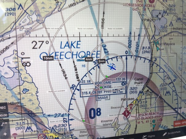


 Entrance to Caloosahatchee on west side of lake and near Clewiston Bloom is all through lake.


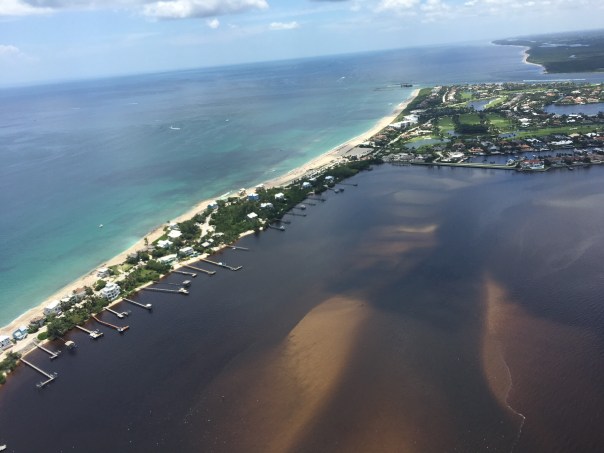


 For years, I have had a reoccurring dream.


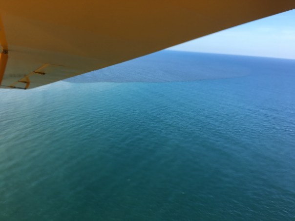


