12-4-17, ca. 2:45 pm, photos: Ed Lippisch & Jacqui Thurlow-Lippisch
The Army Corp of Engineers has lessened but not stopped Lake O discharges that started September 20th, 2017 just prior to Hurricane Irma. Perhaps as the discharges have gone on at such a high rate for a comparatively long time, the plume has had a chance to extend its territory. In yesterday’s photos, the dark, filthy plume is reaching clearly south beyond the exclusive Town of Jupiter Island.
Yesterday was a beautiful day, but the river and ocean waters of our entire region were ugly, possibly contaminated. How are we to enjoy our property and lives here?
When viewing the aerials below, please note the blue, sapphire-colored water just on the edge of the discharge plume. Yes, of course all estuaries put forth darkened fresh water after a rain event, and Ed and I could see this occurring just south at Jupiter Inlet. Nonetheless, the black, gigantic plume that we repeatedly endure for the St Lucie River/Indian River Lagoon due to discharges from Lake Okeechobee is an aberration.
Please let’s all support Joe Negron and the public’s work to build the EAA Reservoir; clean & send the water south!
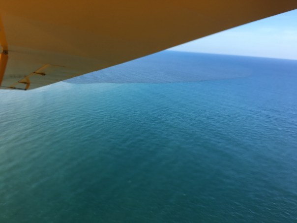
Lake O discharges: http://w3.saj.usace.army.mil/h2o/reports.htmLooking south along the southern most area of Jupiter Island.Looking north along Jupiter Island-dark ocean waters. Jupiter Narrows an extension of the IRL on left.Plume -looking north along Atlantic coastEdge of plume; note clean sapphire colored water juxtaposed to dark Lake O/canal plumeAnother angle, Jupiter Island, looking south-blur due to wind and camera movementBack at St Lucie InletIRL, note bare bottom. This area is known as the Sailfish Flats and once had hundreds of acres of seagrass beds.The Sandbar, a popular weekend recreational area for boaters, especially families, surrounded in dark Lake O discharge waters. This is a health issue.Barren Sailfish FlatsSand bottom with no seagrass between Sewall’s Point and Sailfish Point. An area once teaming with life.The Crossroads — no seagrass beds just sand bottomIRL looking northSt Lucie River near St Lucie Inlet dark as coffeeNorth of St Lucie Inlet the plume covers near shore protected reefs as it does south of the inlet.Blue!The plume as viewed from under the wing of the CubPlume edge: The tainted water we are given by our government; the blue –the water we should have by God & Nature.
“Right now billions of gallons of fertilizer, sewage, and legacy pollution from Lake Okeechobee are spewing into the St. Lucie River, carrying a new threat of toxic algae. Water managers may say Irma left them no choice, but of course that’s a half-truth…”
All photos/videos taken off St Luice Inlet September 30, 2017 JTL/EL
Documentation of primary and secondary plumes at St Lucie Inlet caused predominantly from human directed ACOE/SFWMD discharges post Irma and other from Lake Okeechobee & canals C-44, C-23, C-24, C-25. 10am, September 30, 2017. Primary plume out 3 miles; secondary 3 1/2 and not quite south to Peck’s Lake. We must continue to #ReplumbFlorida #forthefuture #forthewildlife #forthekidz #fortheeconomy for our #indianriverlagoon JTL/EL
My brother, Todd, wrote to me on June 8th noting that the C-44 canal was flowing westwards into Lake Okeechobee rather than dumping eastwards into the St Lucie as is standard operating procedure after a big rain…
Yes this canal, as most of the others, can “flow” in either direction, seemly “backwards.”
So how can this happen? This backwards flow?
Dr Gary Goforth says the following:
“Yes this is normal operations; generally when the Lake level is below 14 ft the Corps leaves the locks at S-308 wide open which allows any local runoff to flow into the lake.”
Another way Lake Okeechobee can receive water in an unusual way is if the water is pumped into it–back pumped. This has recently been done from the EAA. Back pumping into Lake O has been outlawed, but it is allowed if communities or farmland would flood.
According to an exchange yesterday on Facebook, with Audubon’s Dr Paul Grey:
“St Lucie (C-44) backflows are just one of many southern inflows now, S-2 is backpumping, three other southern outlets are flowing backward into the low lake (L-8, S354, S-352) the Caloosahatchee was backflowing but appears equalized today. More water is flowing into the lake from downstream areas than upstream right now. Not the end of the world but not desirable either, it is very polluted water. http://w3.saj.usace.army.mil/h2o/reports/r-oke.html “
When I asked Dr Grey if this was being done to gather water in the lake as we’ve recently been in a drought, or to keep the farmlands in the EAA and surrounding areas dry, this was his response:
“Both, they want to fill the lake this summer, and so do I, in concept, but much of this backpumping and flowing is because the farmers have been pumping water so rapdily off their own lands they have made the canals too deep, and risk fooding the communities. And rather than tell the farmers the canal its too deep and they have to modererate their pumping, the SFWMD backpumps/flow it to the lake.”
In any case, when I visited yesterday during my trip to Belle Glade, S-308 was closed at Port Mayaca and no more water was entering Lake O from C-44. I’m not sure about S-2.
The water looks dark and full of sediment. The once beautiful beach is full of gritty rocks. Maybe the lake is healthy in the shallows south, near the islands, but by Port Mayaca it looks terrible. Algae has been reported by S-308 a few weeks ago according to a report from Martin County at the River’s Coalition meeting. But thankfully there is not algae reported in C-44 right now.
We have really made a mess of it. For our rivers and for Lake Okeechobee, the reservoir must be built and we must continue to advocate for sending cleaned water south and re -plumb this outdated system. Forward flow or backwards flow, just say NO.
6-13-17 JTL
____________________________________
Todd Thurlow notes 6-8-17
Jacqui,
Interesting note: if this data is correct, C-44 has poured 10.7 billion gallons (aka 13.82 Stuart Feet) of water into Lake Okeechobee in the last three days. With all the recent “local” runoff into the canal, they have opened S-308, sending the water west to the Lake to help get the low lake level up.
48.5 million gallons passed through S-80 to the St. Lucie on June 5th…
Structures and canals south of LOCanal and basin map, Martin and St Lucie Co,SLR/IRL. SFWMDC-44 canal from Stuart to Lake O.S-308 at Lake O and C-44 canal Port Mayaca
Numerous wood storks and great egrets eating fish in the polluted side canals of C-44:
Award winning conservation, hunting and fishing journalist, Hal Herring over S-308, the connection from Lake Okeechobee to canal C-44 and the St Lucie River/IRL, JTL 5-13-17Award page Hal Herring, from his web site
At the recent Bullsugar “Fund the Fight” event, Captain Mike Connor introduced me to Montana based, award-winning fishing and hunting journalist, Hal Herring. I looked Hal straight in the eye, shook his strong hand and said, “It’s so nice to meet you Mr Herrington.” He smiled, eyes sparkling, and replied, “Herring mam. Like the fish.”
Fly Life Magazine writes: “Herring, one of the leading outdoor writers of our time, co-manages the Conservationist Blog for Field & Stream, is the author of several books and is a regular contributor to numerous other well-known outdoor news outlets including High Country News, Montana’s Bully Pulpit Blog and the Nature Conservancy magazine.”
To say the least, I felt honored to be chosen as a tour guide for Hal Herring as my husband and Mike Connor arranged an aerial journey for the visiting journalist. After researching Hal, checking out his website, and reading his article on the Clean Water Act, I knew I was dealing with a gifted journalist. What a great person to have learn about the problems of our St Lucie River!
Hal Herring and JTL, Baron’s back seatContemporary Florida canal map ACOE/SFWMD1839 military/Everglades mapDan, Ed, Hal and JTLCanals C-23, C-24, C-25 and most southerly C-44 connected to Lake Okeechobee.
We prepared the Baron for Saturday. My husband Ed invited friend and fellow fisherman Dr Dan Velinsky. The flight stared with a rough take off. I steadied myself. “Please don’t let me puke Lord…” As Ed gained altitude, things settled down and we were on our way…
After taking off from Witham Field in Stuart, we followed the dreadful C-44 canal west to Lake Okeechobee; diverting north at the C-44 Reservoir under construction in Indiantown; traveled over the FPL cooling pond and S-308, the opening to C-44 and the St Lucie River at Port Mayaca. Next we followed Lake Okeechobee’s east side south to Pahokee, and then Belle Glade in the Sugarland of the EAA; here we followed the North New River Canal and Highway 27 south to the lands spoken about so much lately, A-1 and A-2 and surrounding area of the Tailman property where Senate Presidient Joe Negron’s recently negociated deeper reservoir will be constructed if all goes well; then we flew over the Storm Water Treatment Areas, Water Conservation Areas, and headed home east over the houses of Broward County inside the Everglades. Last over West Palm Beach, Jupiter, north along the Indian River Lagoon and then back to the St Lucie Inlet. Everywhere the landscape was altered. No wonder the water is such a mess…
See red triangle left of right circle. This area of A-1 and A-2 and the reservoir is to be located on top of and closebyOld orange grove being made into the C-44 Reservoir/STA, IndiantownFPL cooling pond on edge of Lake O, IndiantownS-308 at Lake O, Port MayacaOver Lake OA-1 and A-2 area, southern EAA with WCA on leftEdge of Conservation areas next to A-1 and A-2 areasBroward County built into EvergladesAlong the SE coast looking south, FPL’s St Lucie Nuclear Power PlantMartin County, St Luice Inlet
I explained the history, Dan told fish stories, Ed ducked in and out of clouds. All the while, Hal Herring took notes on a yellow legal pad with calmness and confidence. Nothing surprised him; he was a quick study in spite of all the variables. He was so well read, not speaking often but when he did, like a prophet of sorts. He spoke about this strange time of history, the time we are living in, when humans have overrun the natural landscape. He spoke about mankind being obsessed with transcending the limits of the natural world…and the control of nature…but for Hal there was no anger or disbelief, just wisdom. In his biography, he says it best:
“My passions as a writer and storyteller lie where they always have – in exploring humankind’s evolving relationship to the natural world, and all the failures, successes and deep tensions inherent in that relationship…”
In the Everglades region, Hal may just have hit the jackpot!
The time is now to fight for President Joe Negron’s Senate Bill 10 to purchase land in the EAA for a reservoir to offset the sometimes toxic, and always damaging, discharges from Lake Okeechobee. The powers that be know the bill is taking some hard hits. They smell blood in the water. Like sharks going in for the kill they are coming from every direction. Just remember, in many instances during a feeding frenzy, sharks turn on each other. So not being a shark myself, I say, “let the games begin…”
Some Major Groups Working Against Negron’s Senate Bill 10.
Reporter Tyler Treadway’s Stuart News articles today poses the question: “Can State Build Reservoir on Public Land to Move Lake O Water South?”So, I thought I’d share this map of Everglades Agricultural Area Lands in Public (State) Ownership along with a list of owners created by the Treasure Coast Regional Planning Council. The piece noted in the article is the around the lighter looking triangle, #10 . It’s a great map and very educational…In any case, with any argument, #SupportJoeNegron
#s enlarged
‘For his part, Negron said he just wants to get whatever land is needed to “store, clean and move enough Lake Okeechobee water south to reduce and ultimately eliminate the discharges. I’m open to considering all options: private land, state land, federal land or any other.” ‘ Stuart News
Satellite image of south Florida. From top to bottom, one can see the Kissimmee chain of lakes, Kissimmee River/canal; Lake Okeechobee; the Everglades Agricultural Area (in red) ; the Water Conservation areas below that; and finally Everglades National Park and Florida Bay. (Public photo NASA, 1980.(http://www.nasa.gov/vision/earth/environment/wetland_freeze.html)
The number one thing I learned as a teacher was that I had to do my best, at all times, and with all students, to be “fair.” This required calling students out when they did something inappropriate, as well as praising them when they did something great.
Two days ago, our friend, Dr Gary Goforth, (http://garygoforth.net),”architect of the STAs,” reported that so far, the SFWMD has sent more water south from Lake Okeechobee, through the Storm Water Treatment Areas, (STAs) than even in 2014, which itself was a “record year.”
This will help save the St Lucie River/Indian River Lagoon….
You may recall prior to 2014, comparatively “little” water had been “sent south,” for a long, long time…meaning more of it went into our estuaries.
Let’s learn:
Below, are summary notes from Dr Goforth that I have edited for simplicity of communication:
Attached is a snapshot of the current flows into and out of Lake Okeechobee for WATER YEARS 2015 (May 1 – January 2015).
Current flows into and out of Lake Okeechobee for Water Year 2015 (May 1 – January 2015). (Chart, Dr Gary Goforth.)
Highlights:
Water years chart showing Lake O water sent to STAs 1995-2105. (Chart Dr Gary Goforth, 2015.)
The District continues to send large volumes of Lake water to the STAs and WCAs: over 416,000 acre feet (136 billion gallons)! which coincidently is the volume of the Lake releases made to the St. Lucie River/Estuary in 2013. During the 3 months of the current dry season (November-January) they have sent over 207,000 AF to the STAs. They are on pace to greatly exceed my target of 250,000 acre feet during the dry season! And they said it couldn’t be done. On a side note – STA performance continues to improve in association with the additional flows.
“Water Year” 2015 now is in the record books for the most Lake water ever sent to the STAs
Also, “Water Year 2015” now is in the record books for the most Lake water ever sent to the Everglades since 1994.
The obvious bad news is that Lake discharges continue to the St. Lucie River/Estuary – at a rate that has practically no effect on reducing the stage of lake Okeechobee (less than 0.1 of an inch per day – less than evaporation).
*Jacqui-please feel free to share this information, with the caveat: “Estimates are preliminary and subject to revision.”
Thank you Dr Goforth for sharing the above good news and kudos to the SFWMD!
___________________
Now as a side bar—I don’t want to confuse anybody, but I do want to share, in case you have noticed too, that sometimes these charts are reported in WATER YEARS and sometimes in ANNUAL YEARS.
For instance, the chart below that I shared in a blog reporting 2014 flows last year shows the report in CALENDAR YEARS. Dr Goforth’s chart above is in WATER YEARS and that is why 2014 in his above chart does not look as high as one would expect it to–as 2014 was also a “record year,” (above 250,000 acre feet sent south.)
Water Sent South report Dr Goforth, 2014 in ANNUAL YEARS. This shows 2014’s water south above 250,000 acre feet reported in CALENDAR YEARS whereas the chart above shows in WATER YEARS.
So what’s the difference? A WATER YEAR is May through April over a two-year period; whereas a CALENDAR YEAR is just that, a calendar year….
I guess the scientists people usually use WATER YEARS…
But sometimes it gets reported in CALENDAR YEARS. Sometimes they don’t specify….Ag!
So anyway, it can be is confusing interpreting these charts. I wanted to make sure that everybody knew both: that in 2014 the SFWMD district sent over 270,000 acre feet south; and in 2015 they have already sent 416,000 acres south! Two great record years after the public outcry following the “lost summer” of 2013.
Although all this water going south is fantastic news, it must be noted as Dr Goforth did, that this is not enough water to “save” the St Lucie River/Indian River Lagoon. This is why the river movement is advocating for the state legislature to purchase option lands south of Lake Okeechobee in order to create an eventual reservoir to store, clean, and convey –closer to the 150,000 acre feet that is necessary to go south so as not to destroy the estuaries…..
But today we focusing on praising good work….
Thank you to all of the hard-working members of the SFWMD who try to balance politics with science, a very difficult classroom! We recognize your good work; we commend you, we thank you. Please keep raising that bar!
Today, I am going to try to simplify and share the idea of an “EAA reservoir.” You probably have been hearing a lot about this, but you may not know how it fits into a an option lands purchase and the “sending more water south” concept that will help save the St Lucie River/Indian River Lagoon, and the Everglades.
This is not fully understood by me either, so I contacted Dr Thomas Van Lent of the Everglades Foundation; he sent me some information that today will share with you.
For me all of this is part of a “flow way concept,” though some may disagree.
Dr Tom Van Lent, Everglades Foundation, (EF). (Photo 2015.)
LAND PURCHASE: In order to do anything that will actually take a significant amount of water off of Lake Okeechobee, so the ACOE doesn’t have to discharge to the SLR/IRL and Caloosahatchee, there needs to be land to “store, clean and convey that water south.”
Because over the past 95 years, the EAA took up all the southerly land to create their Everglades Agricultural Area, 700,000 acres of land south of Lake Okeechobee, we are “forced” to purchase lands in the EAA to move any water south. Thankfully, land is for sale; although US Sugar rather not sell it. (Long drama….let’s just leave it at that–the land is for sale; I believe the state should buy it with Amendment 1 monies and /or “bond it.”) This Option 1, the brown lands below, runs out in October of 2015.
Option Lands Map SFWMD River of Grass, Option 1 is 46,800 acres and shown in brown. (SFWMD map, 2010)
So after getting the land purchase necessity out-of-the-way, let’s look at Dr Van Lent’s write-up and slides:
Jacqui, I’ve attached a graphic that I hope will help explain.
I think everyone can agree that the best solution to the estuaries’ problems is to send more water south. But the major limitation to doing that today is (1) the water is polluted and would irreparably damage the Everglades and (2) the dams in the Everglades prevent you from getting the water out, so adding more water would drown tree islands and other habitats. So, the bottleneck to flow is actually further south, in the Everglades, and not in the EAA.
The solution is to clean the water and then remove the dams. But if you just pull out the dams so water flows when it’s wet, then the Everglades will dry up and burn when it’s dry. So an essential step to pulling out the dams is to add water supply reservoir so that you can keep the Everglades wet during droughts.
The Central Everglades Plan started to open up the dams in the Everglades, but was limited because it did not build any storage. With storage, you can open up the Everglades even more, sending more water south.—–Dr Van Lent
—-I have to say I don’t know much about the dams in the Everglades, but that’s OK, let’s move on….
Slide 1. (EF, 2015.)
(Refer to above slide.) Discharges to the Everglades are limited because the STA’s (Storm Water Treatment Areas) (1.) are too small and cannot clean enough water. Also, dams in the Everglades (2) limit the flow through the Everglades. This leaves the St Lucie/S IRL and Caloosahatchee (3) as the primary outlets for Lake Okeechobee.
Slide 2. (EF, 2015.)
(Refer to above slide.) The “*Restoration Strategies” expansions to STAs (1) and water quality features in *CEPP (2) expanded the ability to treat Lake water going to the Everglades. Moreover, CEPP and Tamiami Trail (3) bridging opened up the Everglades to take more flow, improving conditions in the national park and Florida Bay. The means that significantly less water could be discharged to the St Lucie and Caloosahatchee estuaries (4). The EAA Reservoir (5) supplies water during dry periods so the Everglades remains set seven when the dams are removed. That is why a reservoir is critical to sending water south; it allows the dams in the Everglades to be breached.
Thank you Dr Van Lent!
__________________________________________
In case you are wondering, I have added the following below, to explain Dr Van Lent’s slide explanation.
*Restoration Strategies is basically making the STAs larger due to a long going law suit of the federal government against Florida that was finalized in the past few years under Gov, Scott. The lawsuit occurred because of the dirty water from Lake O polluting the Everglades: This IS happening and the state has to pay for it, 880 million.(http://www.sfwmd.gov/portal/page/portal/xrepository/sfwmd_repository_pdf/rs_waterquality_plan_042712_final.pdf)
*CEPP the Central Everglades Planning Project of part of CERP (the Central Everglades Restoration Project.)(http://www.saj.usace.army.mil/Portals/44/docs/FactSheets/CEPP_FS_September2013_508.pdf) This is a project that was “fast tracked,” by the ACOE and SFWMD. Congressman Patrick Murphy helped a lot with this. It was not taken on as part of WRDA the Water Resources Development Act that funds projects so it is still on the burner really and will have to be approved the next time a WRDA bill is passed by the US Congress. So right now it is NOT happening but hopefully will in the future…
In closing, I hope these slides, and the explanation from Dr Van Lent helped you in your journey of understand all this. I believe all these things are part of a greater whole. I am very appreciative to Dr Van Lent for sending the slides. What an honor to correspond with him.
When one looks at such, one certainly realizes we are planning for a far off future…and nothing is guaranteed. This can be discouraging, but don’t let it be!
It is our responsibility to the children of the future.
Please write a short email to the Florida Senate in support of purchasing Option Lands this 2015 Legislative Session: (http://www.flsenate.gov/media/topics/wlc) Thank you!