Tag Archives: st lucie river

Aerial Update SLR to LO 8-6-23

Ed’s comment when he came home from flight yesterday  was “not as bad as last time.”

Today’s aerials were taken 8-6-23 around 1:30pm. One can see blue-green algae, along the eastern shoreline of Lake Okeechobee, but not as much in the C-44 canal.

The St. Lucie River looks a bluer near Sewall’s Point- perhaps thanks to recent full moon tides and less rain runoff. Seagrass meadows covered in increasing a cyanobacteria and macro algae are visible. The seagrass is returning, but not in as good a shape, after massive and longterm Lake O discharges in 2018, 2016, and 2013 and decades of destruction.

Sandbar near St. Lucie Inlet, 8-28-23, FB Mike Yustin

Ed and I  continue to be your “eye in the sky” and Todd is helping all of us keep an eyeonlakeo now at 15.30 feet according to the SFWMD. Hurricane season should start ramping up. It is not a good situation. More water should be able to be sent south as God intended.

~Lake O, Rim Canal, and C-44 at Port Mayaca’s S-308

~St. Lucie River-Indian River Lagoon. Sewall’s Point divides these waters.

~Note seagrass beds in next two photos. Once 700 acres now much less and impaired.  Good to see it in any case!

Thanks Ed!
Canal system of CSFP SLR/IRL. credit SFWMD


Ed’s Aerial Update 41 minus 2 days after the discharges, SLR

Sailfish Flats devoid of visible seagrass

My husband Ed took these aerials yesterday March 4, 2023 around 11am. He described it as a “mid tide” between high and low. Also swinging by Port Mayaca, at Lake Okeechobee, this time there was no visible algae.

Following Ed’s aerials I am including those of Dr. Scott Kuhns whose photographs taken on February 27, 2023 around 10am showing streaks of algae caused the ACOE to close gate S-308 at Port Mayaca for about 2 1/2 days. Kudos to Dr Kuhns! And thank you to the ACOE for closing! 

So the pictures directly below are Ed’s 3-4-23 and those following are Scott’s 2-27-23. We will continue to document the discharges with hopes they will be halted. We all agree that St Lucie River suffers under the discharges. She was taking water to avoid algae in summer. No one thought algae sightings would begin so early in February, but they have. With this discovery, it is time to 🛑 stop! Cyanobacteria is impossible to 100% track and understand. It is too ancient and will outsmart us every time. Close the locks.

IRL/SLR Sewall’s Point to Stuart
Sky River Warriors since 2013. Pilots & friends Dr Ed Lippisch & Dr Scott Kuhns. This photo was taken by JTL in 2016.
February 27 by Dr Scott Kuhns. This photo caused the ACOE to close S308 for two and one half days.

Ed’s Aerial Report 17 days after discharges begin 500 cfs, SLR

Today is Ed and my 18th year anniversary. I don’t have a lot of time to go through Ed’s recent photos as we document the discharges so I am just going to post all -of the St Lucie River/Indian River Lagoon from February 8, 2023 taken around 1:23 pm. There are only subtle nuances between them. The ACOE started discharging 500 cfs from Lake Okeechobee on January 22, 2023. You can see the effects in these photographs. The water  is able to clear near the St Lucie Inlet at this time. No seagrass in sight. Please see previous post to compare. I will write more soon.

Ed Lippisch

Palm City, FL 1966 Then and Now w/ Todd Thurlow

Today’s blog post is about western Martin County Florida’s Palm City. This post includes  my mother’s inspiration, my brother Todd’s  time capsule flight video, and my writing.

Palm City was once narrow strips of pine flatlands interspersed with hammocks, ponds, wide prairies, sloughs, sawgrass and cypress trees. Today it is a bustling part of Martin County due to the drainage of the C-23 canal on the north, and the C-44 canal on the south. When one attempts to unravel the long history of drainage of Palm City, it is helpful to think in three connected but separate levels: local, state, and federal. 

In 1919  the Palm City Drainage District was created. It was established for a local level as a special drainage district by the Florida Legislature with a lifetime of fifty years. It was primarily created to drain newly established Palm City Farms. Miles of canals and ditches were dug to drain into Bessey Creek, Dansforth Creek, and the South Fork of the St Lucie River. Some of these canals and ditches still exist today or have been incorporated into larger canals.

Palm City Drainage District Docs. 1919

Digging of the St Lucie Canal in the south began around 1915  lasting into 1926. It was dug by the Everglades Drainage District, State of Florida, from the South Fork of the St Lucie River to Lake Okeechobee. After the deathly hurricane of 1928, the federal government authorized widening and deepening the St Lucie Canal to create the Okeechobee Waterway also known as the Cross State Canal from Stuart, across Lake Okeechobee, to Ft Meyers. Doing so allowed the St Lucie Canal to conveniently function as the main outlet for Lake Okeechobee’s flood waters. Later, after the great flood of 1947, the canal became part of the Central and Southern Florida Plan and renamed C-44 becoming part of the giant Central and Southern Florida Flood Control System of the Army Corp of Engineers.

The great flood of 1947 called not just for the widening and depending of the St Lucie Canal and enlargement of its structures, but the federal Flood Control Act of 1948 authorized more canals, levees, and structures  to be built by the Army Corps of Engineers throughout southern and central Florida. Among the new canals were the C-23, the C-24 and C-25 canals of Martin and St Lucie counties -all discharging into the North Fork of the St Lucie River. The state asked for and supported this. The C-23 is the border between Martin and St Lucie Counties. Of course there were major unintended consequences that added to the discharges of the St Lucie Canal and the original Palm City Drainage District. This plethora of fresh, dirty water has all but killed the St Lucie River. Improving the health of the St Lucie is the goal of local, state, and federal restoration efforts today.

The video below created by my brother Todd begins in 1966 after all the aforementioned canals were constructed. It is easiest to see in a large format. You can either click on the YouTube image below or use this link to watch this remarkable Palm City time Capsule Flight!

*Click on link to watch video by Todd Thurlow

-Below: the federal government’s (ACOE) Central and Southern Florida Flood Control Project authorized by Congress in 1948 included C-23 on the border of Martin and St Lucie Counties, C-24, and C-25,- and enlarging the flood control structure along the St Lucie Canal. Once this system was built out it was turned over the state of Florida’s Central and Southern Flood Control District; however, the ACOE kept the St Lucie Canal now named C-44, for federal flood control. The Central and Southern Flood Control District, a Florida state agency that followed the Everglades Drainage District in 1949, became the South Florida Water Management District in 1977. -Below: A 1973 C&SFP update map, Army Corp of Engineers. Green never built thank God!

A Different View, St Lucie River~Indian River Lagoon

-Indian River Lagoon & St Luice River meet to flow into the Atlantic Ocean as seen over the savannas. Nettles Island , a landmark, juts into the IRL (upper left.) Note peninsula of Sewall’s Point and St Lucie Inlet. Aerial photograph by Ed Lippisch, 9/11/22, 6:15pm.Recently, I have been asking Ed to get a “different view” while flying-something other than the location between Sewall’s Point and Hutchinson Island near the St Lucie Inlet. That area is the heart of the matter when documenting seagrass recovery or destructive discharges from Lake Okeechobee. However, the St Lucie River/Indian River Lagoon includes much more than that. The undeveloped savannas region seen above is quite striking.

Here Ed looks south over the savannas, now Savannas Preserve State Park, an area west of the railroad tracks stretching ten miles between Jensen Beach and Fort Pierce.

As my mother, author Sandra Thurlow writes  in her book, Historic Jensen and Eden on Florida’s Indian River, …”ours is not a savanna at all. A true savanna is grassland with scattered, small drought resistant trees. Many eons ago the Jensen Savannas was a lagoon like the Indian River. Now the ancient lagoon is a region of lakes, marsh and pine flatwoods. When polar icecaps formed, bringing Florida out of the sea, tides and winds shaped a primary dune along the east coast of the peninsula. The shallow waters in the wetlands behind the dune were brackish. The ocean levels continued to drop and sand bars just off the coast were exposed, forming Hutchinson Island. What had been the primary dune became the Atlantic Coastal Ridge.” 

She goes on to explain that prior to modern times the savannas’ ecosystem was almost 200 miles long, but due to development along the Indian River Lagoon the region has been reduced to just ten ecologically intact miles.

Areas such as these “savannas” are critical to the health of the St Lucie River/Indian River Lagoon and an inspiration for more comprehensive protection in the future.

Hope you enjoyed today’s different view.


28 Days After the Discharges~2021

Documenting the Discharges, Saturday, April 3, 2021.

Since last week, the ACOE has lowered discharges to the St Lucie River from 500 cubic feet per second to 300. The lake is now down to 14.44 feet from over 16. Blue-green algae has been spotted in the C-44 canal near S-80 at St Lucie Locks and Dam. This canal connects Lake O to the St Lucie River and blue-green algae is always of concern as reported my Max Chesnes of TCPalm. Ed and I saw no algae at S-308 on Lake Okeechobee from the air. The water does have an odd hue-perhaps due to wind. We did not get over S-80 due to weather conditions.

This go around, the ACOE began discharging on March 6, 2021 to the St Lucie River, so yesterday, when these photos were taken it was 28 days after the discharges. The aerials were taken from about 3000 feet, at approximately 3:30pm, on an outgoing tide. Conditions were  windy, cloudy, and all  waters were stirred-up.

Please note federal, state, and local links on subject following  photographs.

~Wishing all a Happy Easter and Spring time! See you next week. Ed & I will continue to document the discharges.

J&E

Running images of S-308 at Port Mayaca, Lake Okeechobee and over the St Lucie River/Indian River Lagoon near Sewall’s Point the dividing peninsula of these waters-merging at the Crossroads and Sailfish Flats near the St Lucie Inlet. Photos Ed Lippisch.

USACE to reduce Lake Okeechobee releases beginning April 3, 2021.
U.S. ARMY CORPS OF ENGINEERS, JACKSONVILLE DISTRICT
Published April 2, 2021: (https://www.saj.usace.army.mil/Media/News-Releases/Article/2560023/usace-to-reduce-lake-okeechobee-releases-beginning-april-3/)

-Notice of Algae (https://www.saj.usace.army.mil/Missions/Civil-Works/Navigation/Notices-to-Navigation/Notice-to-Navigation-2021-007-Okeechobee-Waterway-Algae-Notice/)

(B) Florida Oceanographic Society WQ Report March 31, 2021:(https://mailchi.mp/floridaocean/waterqualityreport2021-1215216?e=0a1cb67484)

South Florida Water Management District operations recommendation to the ACOE March 30-April 5 2021. Ops_Position_Statement__Mar_30_April_05_2021

SFWMD March 31, 2021 visual water levels update and newsletter sign up.

Martin County Health Department Blue Green Algae St Lucie River, April 2, 2021.

Canals killing the St Lucie River-

SFWMD canal and basin map. C-44 canal is the canal most southerly in the image connected to Lake Okeechobee. Note S-308 at Lake O and S-80 at St Lucie Locks and Dam.

7 Days After ~Discharges March 2021

~Ed takes a picture at 3000 feet

I. HELPFUL INFORMATION:

1. ACOE Statement regarding discharging March 5, 2020

2. Lake Okeechobee level 15.06 feet

3. ACOE Pulse Release Schedule: 4.SFWMD staff’s recommendation to the Corps regarding Lake Okeechobee operations       for the period March 2 to March 8, and March 9 to March 15, 2021: Ops_Position_Statement__Mar_02_08_2021 

Ops_Position_Statement__Mar_09_15_2021 

5. Florida Oceanographic’s Weekly Water Quality Report 

6. HAB update and science data: Todd Thurlow’s website eyeonelakeo

II. DOCUMENTING THE DISCHARGES -all photos taken 3-13-21 by J&E on outgoing tide around 1pm. Friday, March 5, my husband Ed and I , took aerials of the St Lucie River/Indian River Lagoon just one day before the Army Corps of Engineers began discharging to the St Lucie River on March 6, 2021. I can’t say that in all our years of taking photographs since 2013, we have done so just one day before discharges began. Thus, now Ed and my goal is to take photos every week as long as the discharges continue. This will give us a really good opportunity for visual comparison.

We all know a picture speaks a thousand words…

Today, Saturday, March 13, 2021, is exactly one week after discharges began-(this time). You can see last week’s photos here! Do you think they were prettier than todays? I must admit, today, the water coloring looked better than I anticipated and that’s good news. This may not be the case in the coming weeks especially if the ACOE ups the discharge level.

We shall see.

~Jacqui and Ed

-St Lucie Inlet and Sailfish Flats at Sailfish Point-Sailfish Flats with no visible seagrass-St Lucie Inlet -A faint plume is visible going south along Jupiter Island-St Lucie River and Indian River Lagoon-Looking south over Hutchinson Island at St Lucie Inlet-Views north along Indian River Lagoon -At St Lucie Inlet looking over Jupiter Narrows to Port Salerno and Stuart-Water just outside St Lucie Inlet on north side, reefs visible as is sediment exiting inlet -Another view encompassing almost all: St Lucie River, Southern Indian River Lagoon -Looking south towards Palm City where the South Fork connects to the C-44 and Lake Okeechobee when structure S-80 and S-308 are open. -Looking east toward the cross shape and forks of the St Lucie River. IRL in foreground. Sewall’s Point lies between the St Lucie and IRL.

Day Before the Discharges, March 5, 2021

Yesterday, Friday, March 5, 2021, around 3:30pm, my husband Ed and I, took a flight over St Luice River/Indian River Lagoon. We knew we needed to document because word on the street had been that there was a good chance, with Lake Okeechobee over 15.00 feet, and rainy season approaching, the SFWMD and ACOE would soon be recommending a special HAB DEVIATION-discharging to the estuaries. Since 1948, the two agencies have worked together to manage the Central and South Florida System

In any case, when Ed and I heard the announcement 4:48pm, less than an hour after arriving home from our flight, -that the ACOE would open S-80 at St Lucie Locks and Dam from Lake Okeechobee- “tomorrow, March 6th,” we were speechless. 

“Wow. Thank God we got up in the plane,” I said to Ed. 

Today, I offer our St Luice/Indian River aerials as a visual day-before-discharges baseline.  Of course I am terribly disappointed. Ed keeps telling me I need to cheer up. I doubt that  I will, but I can say that  I am grateful that now water will also start going south, and that natural resources are being taken into consideration by the agencies. Unfortunately, there are not so many natural resources left. 

~As we have since 2013, Ed and I will continue to document the discharges. 

Please read the ACOE March 5, 2021  announcement to begin Lake O discharges to the estuaries.

For the technical, please read the SFWMD Operation Position Statement March 4, 2021: Ops_Position_Statement__Mar_02_08_2021

SFWMD image: C&SFFCP’s canals to the St Lucie. The western C-44 and Lake Okeechobee had no historic connection the the St Lucie River. The first five photos were taken in the area of the St Lucie Inlet over Sailfish Flats between Sewall’s and Sailfish Points. The flats presently are devoid of seagrasses. -Looking east over the St Lucie/Indian River estuary from Stuart to the Atlantic Ocean.-Looking south to Jupiter Narrows of the Indian River Lagoon. The St Lucie enters around the peninsula of Sewall’s Point. -St Lucie Inlet and “Crossroads/” Where the St Lucie and Indian River meet and exit the St Lucie Inlet.  -Close up of St Lucie Inlet and Crossroads.-Looking north, up the Indian River Lagoon.  -Jupiter Narrows looking south over Peck’s Lake. Note a controlled burn in Hobe Sound in the distance. -North fork of the Loxahatchee River lies in Hobe Sound and Jupiter just south of the St Lucie River. -Circling back over the St Lucie Inlet near St Lucie Inlet State Park on Jupiter Island. Here you can clearly see the waters that lie between Sewall’s Point and Sailfish Point at the Crossroads of the SLR/IRL. -Looking west over Sewall’s Point and Witham Field towards Stuart one sees the north and south fork of the St Lucie River and the Indian River Lagoon on the west side of the peninsula. Look hard and you will see the straight line of the C-23 canal-the boarder of Martin and St Lucie Counties.

Documenting the Discharges, December 2020

Documenting the Discharges, December 2020

Eyeonlakeo

I posted most of these photos on Facebook, but today I will give explanations and document on my blog. From above, our St Lucie/Indian River Lagoon remains beautiful, but we must be sensitive to the losses beneath the waters. These aerials were taken during  a “slack tide” between 12 and 2pm on December 9, 2020 by my husband, Ed Lippisch. December 9th was the last of five days the ACOE stopped discharging from Lake Okeechobee; however S-80 was discharging “local runoff.” (Click on chart above.) Unfortunately, due to high lake level and lack of storage reservoirs, since these aerials were taken, the ACOE has begun ramping up Lake discharges once again. 

Below Lawrence Glenn of the South Florid Water Management gives a comprehensive ecological report covering low-salinities and loss of oyster spat in the St Lucie and other aspects, positive and negative, for the entire Everglades system.

Below is an explanation of aerials documenting discharges December 9, 2020. All photos by Ed Lippisch.

-S-80 at St Lucie Locks and Dam discharging local basin S-80 runoff on December 9, 2020

S-308 at Port Mayaca, Lake Okeechobee closed on December 9, 2020. No algae visible. 

-Plume of along Jupiter Island south of St Lucie Inlet

-Dispersing plume in Atlantic Ocean just past Peck’s Lake in Jupiter Narrows

-St Lucie Inlet -St Lucie Inlet State Park, Sailfish Point, Sewall’s Point, Stuart, Jensen 

-Looking north to Sailfish Flats between Sewall’s Point and Hutchinson Island. This area has greatly degraded since 2013 as far as loss of seagrasses and fishing opportunities 

-The area below, especially around Sailfish Point, was once considered “the most biodiverse estuary in North America” as documented, first, by Grant Gilmore

-This photo reveals seagrass loss across many areas of the Sailfish Flats 

-Another view between Sewall’s and Sailfish Point, a seeming desert…

-Close up, Sailfish Point 

-Sewall’s Point, east Indian River Lagoon 

-Sewall’s Point is a peninsula surrounded by the St Lucie River on west side, and Indian River Lagoon on east side 

Ed Lippisch, selfie. Thank you Ed! 

As you can tell, I have lots of people helping me. Whether it is Ed flying or my brother Todd who provides an incredible easy to read website called EyeonLakeO. You can click below to check it out. The more we know, the more we document, the more we can overturn the destruction of our beloved estuary…

Eyeonlakeo website by my brother, Todd Thurlow. 

Documenting the Discharges 2020

Today is October 26, these photos/videos were taken over the weekend on October 24, 2020. The first is the St Lucie River looking off the Evan’s Crary Bridge at Sewall’s Point; the second is a video of the St Lucie River taken between Rio and Stuart; and the third is a video of a brown ocean at Peck’s Lake. The St Lucie River/Indian River Lagoon and much of the east coast of South Florida have endured tremendous, repetitive downpours in 2020, causing massive “local basin runoff.” The St Lucie has been stressed for months, and since October 14, there are also discharges from Lake Okeechobee. Prior to that, there had been no Lake O discharges since March of 2019. This post is written to document this discharge era for today and for later reference.

1-Video visual water quality from boat, wide St Lucie River near Rio 10-24-20


2-Video visual water coloring, Atlantic Ocean at Peck’s Lake, south of St Lucie Inlet 10-24-20


DOCUMENTING THE DISCHARGES 2020

Map SFWMD showing canals and basins. C-44 is designed to discharge both basin and Lake O water, depending. When flowing, C-23 and C-24 are constant polluted discharges. More often than not, the St Lucie receives more polluted fresh water discharges from these canals than the river can handle.

Covid-19, an active hurricane season, and the 2020 presidential election have captured our attention, but most of know, as this Tyler Treadway Stuart News article reports, much to our dismay, due to a high rate of Lake Okeechobee rise, and after weeks of media briefings, and warnings, a reluctant  ACOE started discharging to the St Lucie River on October 14th. Thankfully, for much of the time, it has been difficult due King Tides. The discharges are expected at least another week longer if not a month depending weather and rainfall from Tropical Storm Zeta. See link below from the ACOE’s  most recent, 10-20-20, Periodic Scientist Call for more info. 

Periodic_Scientists_Call_2020-10-20

EASY REFERENCE FOR ALL 

The most comprehensive place to keep track of all this is Todd Thurlow’s website  (http://eyeonlakeo.com) that provides a multitude of easily interpreted information. Check it every day, especially LIVE DATA and Satelitte NCCOS HAB images of Lake Okeechobee.

FACEBOOK UPDATES

Michael Conner, THE INDIAN RIVERKEEPER keeps an active Facebook page on Lake O discharge and other local issues and is often on the ground reporting.


I am not happy about the discharges, however, I am pleased to report that the SFWMD has created a transparent website page where one can learn all that is being doing to try to curb the harmful discharges to the estuaries. The SFWMD is working hard to send water south even during this very rainy hurricane season. And each year we must figure out how send even more water south. https://www.sfwmd.gov/content/district-actions-reduce-harmful-discharges-northern-estuaries

Also on 10-14-20 The Florida Department of Environmental Protection put out a press release: “Governor Ron DeSantis Announces Preparation for Algae Bloom Mitigation Following Announcement by Corps of Releases From Lake O.” This technology has not been needed thus far. 

I can’t forget to include that October 11, 2020, right before the discharges began,  Ed and I took this video documenting a significant algae bloom in the middle of Lake Okeechobee. Since that time it has been too stormy, or cloudy to go up. Usually, rain and lack of sunshine minimize visual blue-green algae blooms as can be seen on Todd’s website. The algae does remain in the water column. This image/video was shared by many news stations and posted on Facebook.

3-Large algae bloom in middle of Lake Okeechobee, 10-11-20.

Next , I would like to document  Florida Oceanographic CEO, Mark Perry’s recent op-ed as it gives us pause. “Why can’t, why aren’t we able to send more water south?” We know a lot has been done, and we are grateful, however,  2020 is not 1948, we must continue to advocate for a better water future…

OP-ED MARK PERRY,  PUBLISHED IN STUART NEWS, October 15, 2020

Lake Okeechobee discharges can go south now.

As the water level rises in Lake Okeechobee, the U.S. Army Corps of Engineers is considering discharges to the coastal estuaries, the St. Lucie to the east and Caloosahatchee to the west.

According to the Lake Okeechobee Regulation Schedule, the Corps considers where the lake level is at this time of year within the “operational band,” which ranges from 10.50 to 17.25 feet of elevation. Then, based on the rainfall outlook and tributary conditions, they determine “allowable Lake Okeechobee releases” to the water conservation areas and to the estuaries.

The water conservation areas (900,000 acres) are the remnant Everglades, south of the Everglades Agricultural Area (EAA) which is the 700,000 acres immediately south of the lake used primarily for growing sugarcane.

For “allowable Lake Okeechobee releases” to the estuaries, the Corps has specify flow amounts going to each estuary, which can be “up to 4,000 cubic feet per second (cfs) to the Caloosahatchee and 1,800 cfs to the St. Lucie.” 

That is where they are right now with the lake at 16.02 feet elevation.

But the “allowable” releases to the water conservation areas are always “up to maximum practicable.” What does that mean? Well, they rarely talk about how much they can release to the water conservation areas, and never tell us how much should be considered to go south.

In fact, water has been flowing south into the water conservation areas all throughout this wet season, May through October.

But it is not coming from the lake.

About 955,000 acre feet (311 billion gallons) has been going into the water conservation areas from the EAA basin runoff. This means that they are keeping the EAA water table down to 10.5 feet — ideal for crops — by draining all this water through our 57,000 acres of stormwater treatment areas and into the water conservation areas — the Everglades.

Meanwhile, the Corps says they must discharge Lake Okeechobee to the estuaries because they can’t release it to the south. Well, they can — they have been doing it for months and they still are today, but it is all coming from the EAA basin runoff!

All this time, we could have been releasing lake water to the water conservation areas, and we could do the same right now instead of killing the estuaries with releases and wasting this water to tide.

But for that to happen, we need to tell the EAA to store and treat runoff on their own land so the stormwater treatment areas can be used for water flowing south from Lake Okeechobee.

The Corps and South Florida Water Management District are jointly responsible for managing water in south Florida. We need to have them focus on restoring more natural water storage and treatment north of the lake, in the 2.5 million acre watershed, so the lake doesn’t fill up so fast.

But we must also get them to flow south from the lake to the Everglades during the wet and dry seasons. We don’t have to wait for huge regional projects to be authorized and completed, we can do this now.

The lake is rising quickly because the EAA is using the capacity to send water south. Agricultural interests would like it to stay high because during the dry season, November thru April, the EAA will demand water from the Lake, about 350,000 acre feet, as water supply for their crops.

These are ideal conditions for the EAA, but not so good for the lake, the greater Everglades ecosystem and the coastal estuaries.

Mark Perry is executive director of the Florida Oceanographic Society in Stuart.

Below are Florida Oceanographic’s most recent St Lucie River/Indian River Lagoon water quality reports

October 14, 2020:

October 21, 2020

—————–

Finally: During Rivers Coalition meeting 10-22-20 more expansive documentation/reporting  of on-going seagrass loss/slow recovery in the St Lucie River/Indian River Lagoon was requested. It was noted that SFWMD “Ecological Reports” cover only two historical seagrass areas of the once lush and healthy Sailfish Flats. 

How Things Change ~1971 Aerial East Ocean Blvd.

Stuart, St Lucie River, Sewall’s Point, Indian River Lagoon, and Hutchinson Island, Atlantic Ocean, Martin County, Florida 1971

St Luice Blvd (L) East Ocean Blvd.(R)  1971, courtesy, archives historian Sandra Henderson Thurlow.

“I have enjoyed looking at this aerial taken in 1971. Too bad our little house on Edgewood is out of the photo. It shows the location of the future Monterey Road through the Krueger property. The Krueger building to house Merrill Lynch has not been built yet but you can see the little surgery center was already built. I think I can see Mimi and Grampy Tom’s house in Snug Harbor–at least the driveway. So many things yet to be built.” Mom

My mom, local historian, Sandra Thurlow, recently shared this aerial with my brother, sister and me as we grew up here in Martin County. It’s a really great photograph capturing a growing community. Look how Hutchinson Island, Sewall’s Point, and even parts of East Ocean were undeveloped. No Indian River Plantation, later renamed “Marriott Hutchinson Island.” No Cedar Point Plaza. No Benihana! White sands shine through the remaining forest denoting scrub habit, home to threatened and endangered scrub jays and gopher turtles. This sand pine scrub habitat that made up most of Florida’s east coast is now considered one of the most endangered habitats in the world. The East Ocean Mall on the right sits next to a flower farm. At this time flower farms were giving way to roads and development. Already, the freshwater ponds have been directed and drained, and obviously thousands of sand pines have been mowed down for condos, houses, farms, roads, and shopping centers. By 1971 this area was fully on its way to build-out as we see below in 2020.  Nonetheless, from air and ground this area of Martin County stands out as one of the most beautiful.

But it would be fun to bring back some of the scrub habitat ~easy to do by just altering our yards. How things could change…

Close-up Google Earth 2020
Google Earth 2020


Beautiful -But I See Some Algae at Port Mayaca…

Family friend Scott Kuhns is a great dentist, pilot, and photographer. For years, Scott has been one of our “eyes in the sky,” taking flight over the St Lucie River-Indian River Lagoon -and west out to Lake Okeechobee. 

Today, Sunday, May 3, 2020, before noon, Scott forwarded these striking photos. He wrote “I can see some algae at Port Mayaca.”

When I first reviewed the impressive photographs -coast to lake- I found it hard to believe, but indeed looking very closely, there is a wisp of algae close to S-308 at Port Mayaca in Lake Okeechobee.

Can you see it? When things are so beautiful, like right now, it’s easy to miss!

Thanks Scott for your continued service “River Warrior” extraordinaire! We will continue to keep an eye on the water as we move closer to hurricane season. 

ST LUCIE INLET, CROSSROADS OF INDIAN AND ST LUCIE RIVERS DIVIDED BY SEWALL’S POINT, ~ALL PHOTOS BY DR SCOTT KUHNS

JUPITER NARROWS & ATLANTIC OCEAN SOUTH OF ST LUCIE INLET

C-44 CANAL at ST LUCIE LOCKS AND DAM, S-80

S-308, CONNECTION OF C-44 CANNAL to LAKE OKEECHOBEE 

VERY TIP of S-308 with ALGAE WISPS SLIGHTLY VISIBLE, BUT DEFINITELY THERE

INSIDE STRUCTURE S-308, PORT MAYACA LAKE OKEECHOBEE ALONG C-44 CANAL. S-53 ON ANOTHER CANAL. ALSO FPL COOLING POND SURROUNDED ON WEST BY WHAT APPEARS TO BE SUGARCANE FIELDS

REMNANTS OF THE ORANGE GROVE THAT IS NOW THE C-44 RESERVOIR AND STA.

SLR basins. SFMWD. You can see FPL cooling pond just northeast of S-308.


Eyes Out!

DO YOU SEE THIS FIGHTING CONCH’S LITTLE EYES?

Nature is full of surprises that amaze and inspire…

But sometimes we have to LOOK.

I wanted to share these wonderful nature photos taken by my brother Todd, March 28, 2020, near the House of Refuge and the Crossroads of the St Lucie River-Indian River Lagoon. Birds, blue water, and for me, the best of all, the determined eyes of this handsome brown-orange colored fighting conch? Incredible!

This post is a precursor, as later this week I will begin a water quality series that will open our eyes to a “better water future.”

How so? ~My brother Todd Thurlow, creates water quality maps with the help of Dr Gary Goforth and these maps really give insight into nutrient pollution and how it gets into our state waters. I will be sharing and explaining these maps. I figure many of us  have some time as most of us are at home due to the coronavirus pandemic. ” We can learn something while doing the right thing for our country.

~Until then, enjoy Todd’s photos, and may we all, human and mollusk alike, keep our eyes out and keep fighting for a better water future!

Fighting Conch in area of the Crossroads, Martin County, FL ~always return sea snails to the water!

HOUSE OF REFUGE, BLUE KEY, CLEAN WATER #LakeO discharge free ~going on 2 years….

A BROWN PELICAN DIVES FOR FISH NEAR INDIAN RIVER PLANTATION, MARRIOTT

A TALL LEGGED “SANDPIPER” FEELS FOR FOOD (WILLET) 🙂

Adrift’s Indian River Lagoon Water Report, June-July 2019

July 5, 2019

Hi. I hope everyone had a wonderful 4th of July! Wasn’t it exceptional? Exceptional because the St Lucie/IRL’s water wasn’t toxic like so many times in recent years. So nice to be able to enjoy our waterways. No dumping of Lake O. I am grateful!

Today I am a back with an Indian River Lagoon Report for the entire Indian River Lagoon.

During my husband, Ed, and my recent 156 miles trip up the IRL, aboard ADRIFT, I contacted Duane DeFreese Ph.D., Executive Director for the Indian River Lagoon National Estuary Program. I called Duane because I knew why the southern lagoon looked better but was impressed by how good the water in the central and northern lagoon looked as well. No brown tide. No superbloom.

Since am unfamiliar with the waters north of the Treasure Coast, except by books, I wanted a scientific update. Well, boy, did I get it! See Dr. Duane’s comments below. Also included is the invaluable, recent St John’s Water Management District’s “June 20th Indian River Lagoon Conditions Update.”

For visual input as well, I am inserting some of Ed and my photos, with comments, of our incredible journey along what is still considered to be one of the world’s most biodiverse estuaries. What a treasure! From north to south, we must do all we can to ensure a toxic-free future.

Keep up the fight!

Jacqui

IRL map: Researchgate

Ed and JTL start of the trip on “Adrift.”

Location: Jupiter Island near the Jupiter Inlet, as almost always the water here is like the Bahamas, looking great! Near the border of Martin and Palm Beach Counties.

Near Jupiter Inlet, border of Martin and Palm Beach Counties. Wow!

JTL:

Duane, hi. Hope you are having a great summer. At this time, are there algae blooms reported in the IRL near Melbourne, the N. IRL north of Titusville, or anywhere in the Mosquito Lagoon? Thank you for letting me know. Jacqui TL

Duane DeFreese, Ph.D. Exec. Dir National IRL Estuary Program, http://www.irlcouncil.com

Conditions being reported to me by the local guides are consistent with the report and my own observations. Overall water quality looks pretty good, but small, patchy areas of poor water quality continue. The fishing guides tell me one day it looks great and a day later the same area will have color and turbidity (probably patchy bloom conditions). My personal observation is that we have been lucky so far and the system is vulnerable. I would not be surprised to see blooms intensify as we move deeper into summer and the rainy season. Lagoon water temperatures are also really warm. the SJRWMD Report documents that we have had patchy blooms occurring of multiple species. Two confirmed species of concern are Pseudo-nitzschia, a marine diatom and Pyrodinium bahamensis, a dinoflagellate. The worst water conditions continue to be in Banana River and in Sykes Creek. There are boater reports of patchy poor water quality in some areas of the northern IRL. The third species of significant recent concern has been Brown tide (Aureoumbra lagunendis). It was in almost in continuous bloom for most of last year in the Banana River. Bloom conditions have subsided. Aureoumbra thrives in warm, high salinity environments. It is not known to be toxic. Blooms of pseudo nitzschia, a marine diatom, can produce a neurotoxin called domoic acid. Blooms of Pyrodinium can produce saxitoxin. I expect that we will see patchy and flashy bloom conditions of multiple species throughout the summer. If we get lucky, I hope none of these blooms get intense enough to elevate toxin levels, low DO levels and fish kills. I’m very concerned about the slow recovery of seagrasses, even in areas of good water quality. Feel free to call me anytime.  Have a great 4th July!

Indian River Lagoon Conditions Update June 20

JTL:

Dear Duane, thank you so very much for the super informative reply! I wrote because my husband and I are taking our maiden voyage in a trawler. We have gone from Stuart to Jupiter to Vero to Cocoa, north as far as possible in IRL, past Titusville, and today-through the Haul-over Canal into the Mosquito Lagoon. Not being familiar with these waters, all I have seen visually appears quite good compared to the St Lucie and even parts of the S. IRL. Some varying coloration is apparent, but overall seems good and in the north, many baitfish balls are shimmering under the surface and dolphin families are gorging themselves and teaching their young! We have seen many dolphins everywhere. Throughout Indin River County, Ospreys nesting in channel markers. One after the other!  In the Mosquito Lagoon there were many more wading birds than S IRL. Even saw a few roseate spoonbills. I was not expecting it to be so full of life up here… a nice surprise. Not off the chart healthy, but marine and bird life very visible! I really appreciate the info you sent. I plan to blog on trip once home, so I can quote your knowledge. Happy 4th of July to you as well and I hope to see you soon.


The confluence of the St Lucie River and Indian River Lagoon off S. Sewall’s Point, Bird Island. Near Stuart, Martin County.

Sewall’s Point and Stuart, Martin County.

Beautiful blue water near the Ft Pierce Inlet, St Lucie County. Ft Pierce rocks!

Waters of Vero Beach, Indian River County.

Old map showing the designated area of famous INDIAN RIVER LAGOON CITRUS. Citrus Museum, Vero Beach, FL

1920 Blue Heron Map shows clearly the area of the Everglades, Heritage Center and Citrus Museum, Vero.

Street sign in Vero Beach, as everywhere ALL canals lead to Lagoon! No trash, fertilizer, pesticides, etc!

Sebastian Inlet, Indian River County, brings blue waters to the area. So pretty!

Approaching Cocoa Village, north of Melbourne in Brevard County.

Waters nearing Cocoa Village in Brevard County

Ed and I visited the Kennedy Space Center along the Indian River Lagoon and Banana River. Surrounded by the Merritt Island National Wildlife Refuge. Space & Nature. https://www.fws.gov/refuge/Merritt_Island/visit/plan_your_visit.html Such an inspiration!

3-D movie at Kennedy Space Center really took us to the moon, Mars, and beyond!

The ominous Vehicle Assemble Building, NASA, so large it is visible no matter where one is are along the central and northern IRL. It’s like it is following you!

Eau Gallie, Melbourne. The Eau Gallie River, or Turkey Creek,  is a small version of the St Lucie and also impaired due to runoff from agriculture and development.

Like a sentinel, the Vehicle Assembly Building as seen over the Indian River Lagoon north of Titusville.

Baitfish!

Waters approaching Titusville, Brevard County.

Train track bridge north of Titusville, Brevard County.

Train track bridge north of Titusville, Brevard County. Shortly beyond channel turns right through the Haulover Canal and into the Mosquito Lagoon.

Ed navigates through the Haulover Canal, connecting the northern IRL with the Mosquito Lagoon.

Water in the Haulover Canal was greenish.

Entering the stunningly beautiful, peaceful, undeveloped Mosquito Lagoon. This area is flanked by the Scottsmoor Flatwoods Sanctuary and Canaveral National Seashore. Wildlife abounds.

360 of the unforgettable Mosquito Lagoon:

Flora and fauna along shoreline, Mosquito Lagoon

Anhinga twins, Mosquito Lagoon

Incredible footage of 4 dolphins in our wake near Ft Pierce welcoming us home!

ADRIFT is a 2007 Mainship 400 trawler, top speed about 8 knots 🙂

Documenting the Discharges, 3-17-19

*Please note all comments become public record.

1.Ed and the Super Cub 2019. Our “eye in the sky” since 2013.

2.Tip of South Sewall’s Point looking north to Hell’s Gate. Witham Field, Stuart, west.

We continue to document the discharges…

Yesterday, 3-17-19, my husband, Ed, flew the Super-Cub over the St Lucie River/Indian River Lagoon ~ twenty-one days after the ACOE started discharging from Lake Okeechobee on February 24, 2019.

When Ed arrived home, I asked, “So how was it?”

“Brown,” he replied.

“Like dark coffee brown, or kind of like that weird mixed greenish-brown?”

He looked at me, and smiled. “Jacqui, it was brown.”

“OK, I said, I’ll take a look at your photos.”

So here are the photos from Ed’s flight from Witham Field in Stuart, over Sewall’s Point and Hutchinson Island, then out west  to S-80 to see the “Seven Gates of Hell” where you can see the one gate discharging now at an average of 250 cubic feet per second, down from an average of 500 cubic feet per second. As you can see from the SFWMD chart below, there has been other runoff locations as well, but the majority is from Lake Okeechobee.

ACOE Press Release: 3-14-19, ACOE, showing decision to go to 250 cfs to SLR/IRL. ACOE says they are “pulse releasing,” however, these are not the “pulse releases” we are familiar with during prior discharge destruction events, as the number never goes to 0, it just goes up and down. https://www.saj.usace.army.mil/Media/News-Releases/Article/1784910/corps-to-continue-lake-o-release-plan-with-minor-adjustments/

Thank you to my husband Ed, for showing us that right now, the river is brown.

ACOE, Periodic Scientists Call, 3-12-19, http://w3.saj.usace.army.mil/h2o/reports.htm


3. Approaching the SL Inlet, algae covered remaining seagrass beds

4.Sandbar formation inside of SL Inlet

5.Blurry but shows boats at the Sandbar and that weird green brown color

6.Sailfish Point and SL Inlet algae covered remaining seagrass beds

7. Ernie Lyons Bridge, IRL with SL inlet and Hutchinson Island in distance

8. S-80 along C-44 Canal or the Seven Gate of Hell, boats going through locks, “250” cubic feet per second coming though

The following phots are of Caulkins Water Farm, a former orange grove that died due to citrus greening that now holds water from the C-44 Canal. This is a wonderful thing! As local ag-man Mr. Hadad, told me once, “Jacqui we spent 100 years taking the water off the land, and we’ll spend the next 100 years putting it back on.” The later photos are of S-80 again with view of C-44 canal leading west to Lake O.(https://www.facebook.com/CaulkinsWaterFarm/)

9.

10.

11.

12.

13.

14.

15.

16.

17.

18.

19.

20.

21.

22.

23.

24.

The following photos are when Ed headed back to Witham Field going once again over the St Lucie Inlet over the Atlantic Ocean. You can see the water looks blue north of Sailfish Point north of the inlet with nearshore reefs visible. Plume is also visible south of St Lucie Inlet. Also in photos is the winding Jupiter Narrows and St Lucie River in the area of Stuart and Rio. You can see Langford Landing with scraped orange soil and docks built into river still under construction since 2015.

Thank you to my husband Ed, our eye in the sky!

25.

26.

27.

28.

29.

30.

31.

32.

33.

34.

35.

36.

37.

38.

39.

40.

41.

42.

43.

Looking Back, St Lucie River ~Rain and Algae 2018

Even though the water in yesterday’s photo looked gorgeous, lest we forget, here are some images of the St Lucie River/Indian River Lagoon area during a rainy and cyanobacteria ridden 2018.

Ed and I didn’t start taking pictures until were motivated…

In March 2018 there was a tremendous rain event. (https://www.sfwmd.gov/our-work/flood-control/managing-high-water)
My homemade rain gauge showed over 27 inches in just a few days along the coast!

You’ll see that after the rain event, the St Lucie River/Indian River Lagoon looks terrible even with out Lake Okeechobee discharges. This is caused by directed water runoff from C-23, C-24, C-25, C-44 and “local” coastal runoff.  Naturally, the river never took all this water. Humans made it this way, and we must fix it.

SFWMD canal and basin map.

Soon after the torrential rain, the Army Corp of Engineers made things even worse and started dumping from Lake Okeechobee through the C-44 Canal into the St Lucie River by opening up the gates at S-308 and S-80.

My husband, Ed,  first flew over Lake O on June 1st,  just by chance. At this time, he spotted algae on the lake and took a photo.  Ironically, the next day, the Army Corp started dumping from Lake Okeechobee on June 2nd!

The algae or cyanobacteria (http://www.ucmp.berkeley.edu/bacteria/cyanointro.html)
that was festering in the Lake began to show up almost immediately thereafter in the St Lucie River that has also become  a “nutrient porridge.”

The rest unfortunately is history. 2018  was bad, but in my opinion not as awful as 2016 when the ocean was totally green: https://jacquithurlowlippisch.com/tag/bathtub-beach-algae/

After another long, hot summer, the Army Corp finally stopped discharging in the fall~October 5th… Take a look at the photos and remember to enjoy the blue water when it is here, but NEVER FORGET! Only though looking back, will we have the determination to change the future.

Major rain event in March 2018.  Rain filled this vile up many times!

SLR IRL following major rain event in March 2018. This is runoff from C-23, C-24, C-25, C-44,  and “locally” from developed areas along the river and uplands made to drain into river. JTL

Following rain event in March 2018. A brown Atlantic.

Following rain event in March 2018, the SLR/IRL ~Scott Kuhns

Following rain event in March 2018 Sailfish Flats between Sewall’s and Sailfish Points ~Scott Kuhns

June 5th. A very dark plume moves south along Jupiter Island, just days after ACOE begins dumping so this is a combination of all pollution/runoff  waters…

LAKE OKEECHBEE DISCHARGES ADDED

Ed in the Cub after plume photo

Algae as photographed/spotted by Ed in Lake O on June 1st 2018.

City of Stuart, June 9 2018.

Rio near Central Marine, week of June 12, 2018

Photographing a manatee in the algae along seawall by Mary Radabaugh

Mary Radabaugh manages Central Marine with her husband. JTL

Mary found a dead baby manatee floating in the putrid water shortly after LO discharges.  MR

LAKE O: Week of June 16th, June 25th, and July 22nd. Cyanobacteria (blue green algae) blooms and then subsides. ~All the while, this water is dumped into the St Lucie River by the Federal Govt.; the water quality is terrible and this the responsibility not of the Feds but of the State of Florida.

Algae is now very visible in Lake O, June 16, 2018 JTL

June 25, 2018 Lake O, near S-308, Port Mayaca.  JTL

C-44 canal leading to SLR from Lake O.

C-44 canal leading from LO to SLR.

Satellite view LO bloom on June 24, 2018. ~At its height.

By July 22, 2018 the bloom in the LO is lessening, JTL

August 29, algae would come and go, throughout the SLR. Here near Overlook Drive JTL

September 4, algae still “coming and going” ~2018 Snug Harbor, Stuart.  Photo by my uncle, Dale Hudson

October 5, the ACOE stops dumping from Lake O. The blooms stop almost right away but the damage remains….

December 8, 2018 the river looks “normal” again near Sewall’s Point but it is not. JTL

Blue Water on Christmas Day, 2018

What should be normal, was a gift on Christmas Day, blue water in the St Lucie River/Indian River Lagoon. The peninsula of Sewall’s Point shone like the gem it is surrounded by aquamarine on both sides: the St Lucie River on its west, and the Indian River Lagoon on its east…

Feeling like the Bahamas, rather than the toxic-sludge we had to endure ~coming mostly from Lake Okeechobee this past summer, 2018, and yes, remember 2016, and 2013….the destruction must stop!

As 2019 edges into the picture, we will once again have to give everything we have to fight for clean water and encourage our state and federal government to support legislation “sending the water south.”

Seeing these beautiful blue waters once again is certainly encouraging. Now to keep the Army Corp and South Florida Water Management District at bay long enough, as projects proceed, and allow our precious seagrass beds to return so baby fish can once again hide, swim, and grow to maturity in these waters; once christened the “most bio-diverse in North America.”

Thank you to my dear husband, Ed, for these photos all taken 12-25-18. And from both of us, “Merry Christmas!”

Sewall’s Point lies between the St Lucie River and Indian River Lagoon

Sailfish Flats between Sewall’s and Sailfish Point. Seagrass remains bleak after years of discharges from Lake O, and other area canals

St Lucie Inlet opening to the Atlantic Ocean between Sailfish Point and the southern end of St Lucie Inlet State Park on Jupiter Island

Another angle of St Lucie Inlet area

Remnants of once lush sea grass beds off Sewall’s Point

Another angle: Evan’s Crary and Ernest Lyons Bridges on far right

A great shot of the now pathetic seagrass beds. This area was once considered “the most bio-diverse in North America,” with approximately 700 acres of healthy seagrasses in this area between Sewall’s and Sailfish Points

Photo below as a comparison ___________________________________________________________________________

NEVER FORGET! Town of Sewall’s Point, Martin County Florida, 9-2013 surrounded by polluted waters released from Lake Okeechobee. Even the ocean brown! Similar years were 2016 and 2018 both with cyanobacteria blooms along shorelines. This awful sediment, and nutrient filled water is dumped on us by our federal and state government and is a health hazard.

The Heart of the 1947 Central and South Florida Project, the SFWMD

Everglades National Park, JTL

Sometimes the history of the Everglades is really confusing.  Why, with all of the environmental advocacy, since the 1970s, does the health of our environment remain crippled?  One way to simplify it is to think in terms of before and after the 1947 U.S. Central and South Florida Plan. Of course there is extensive history before 1947, but it was after 1947 that things in South Florida’s water world became culturalized, compartmentalized, and legally defined. Before we talk about this 1947 Central and South Florida Plan, let’s review some important highlights pre-1947.

1. Hamilton Disston begins the drainage of Lake Okeechobee (1881)

2. Governor Napoleon Broward hires U.S.D.A. scientist James Wright who determines that “eight canals would indeed drain 1,850,000 acres of swampland” (1904)

3. The U.S. Congress’ Rivers and Harbors Act  includes significant funds to deepen  the manmade Hamilton Disston connection of the Calooshahatchee River to Lake Okeechobee (ca.1910)

4. The scandal of James Wright (from #2 above) who was deemed “a fraud” for the failure of the land to drain as expected ~causing the slump in swampy real estate sales (1914)

5. The resurgence of confidence in sales and a 1920s real estate boom fueled by advances in soil science, and the success of agricultural start-ups located in Moore Haven, Belle Glade, and Clewiston south of Lake Okeechobee

6.  Land in a defined “Everglades Drainage District” more fully being systematically cut into sections for development with canals draining agricultural fertilizers and other chemicals into the waters of the state (1924)

6. Two very powerful hurricanes causing thousands of deaths and the destruction of property, and thus the state’s “call for a higher dike” (1926 and 1928)

7. The state’s reaction to the hurricanes, the 1929 establishment of the “Okeechobee Flood Control District” for the “Everglades Drainage District” as well as the Federal Government’s Army Corp of Engineers taking over “field operations”around Lake Okeechobee ~including the building of a thirty-five foot earthen dike and ingeniously using navigation funding to build the cross-state-canal, connecting the Caloosahatchee and the St Lucie Estuaries to Lake Okeechobee ~conveniently working as discharge-escapes through those estuaries when “necessary”

So, as we can see, a lot happened pre-1947, but it was what happened after, were things really changed…

In 1947 it rained and rained, and there were two hurricanes. From Orlando to Florida Bay the agricultural and developed lands, that had been built in drained, once marshy, swampy areas, really flooded, and in some places a foot of water sat for months. There was great economic loss.

The crying cow booklet, above, was sent to every member of the U.S. Congress.

The country as a whole was empowered with its post World War II success and prosperity, and with that same determination, the U.S. Congress came to Florida’s rescue…

To fight Florida’s destructive “flood waters” the 1948 U.S. Congress adopted legislation for the CENTRAL AND SOUTH FLORIDA PROJECT, a twenty year flood plan from Orlando to Florida Bay that included the formal creation and protection of the Everglades Agricultural Area south of Lake O, the Water Conservation Areas, intertwined with thousands of miles of canals and structures to control the once headwaters and River of Grass. HOUSE DOCUMENT 643 – 80TH CONGRESS (00570762xBA9D6)

Next, mirroring the same terminology the United States Government had used (the Central and South Florid Project) the state of Florida created the “Central and South Florida Flood Control District” to manage that CENTRAL and SOUTH FLORIDA PROJECT. A bit confusing huh? A tongue twister. And in a way one could say, at that time, the Central and South Florida Project and the  Central and South Florida Flood Control District “became one.” The overall goal above all other things was flood control. And this marriage of the Central and South Florida Project and the Central and South Florida Flood Control District was successful at controlling the waters, but it also killed the natural environment, thus Florida herself.

This embedded cultural philosophy of “flood control only” was challenged in 1972 with the birth of the national environmental movement, and a consciousness that the natural system that supported Florida’s tourism, quality of life, agriculture, not to mention valuable wildlife,  was in tremendous decline.

As Florida matured came Governor Claude Kirk, a republican,  in 1968, who was advised by environmentalist Nathaniel Reed. Then came Governor Reubin Askew, a democrat. The Florida Legislature, seeing the destruction of the state’s natural resources, passed a very important piece of legislation, the “Florida Water Resources Act,” today’s Chapter 373 in Florida Statures. (http://www.leg.state.fl.us/statutes/index.cfm?App_mode=Display_Statute&URL=0300-0399/0373/0373ContentsIndex.html)

This law created five Florida water management districts with expanded responsibilities for regional water resources management including environmental protection not just flood control.

Accordingly, the Central and South Florida Flood Control District changed its name, but not its heart, becoming the South Florida Water Management District, we know today…(https://www.sfwmd.gov)

Everglades National Park, JTL

John Moran’s “Florida’s Summer of Slime: Stuart and Lake Okeechobee”

It’s an honor to present:

“Florida’s Summer of Slime: Stuart and Lake Okeechobee,” photo essay by John Moran, August 2018

I reported last month on the plight of the Caloosahatchee River and its befouled waters flowing from Lake Okeechobee; delivering slime to waterfront neighborhoods in Fort Myers and Cape Coral along the way to the Gulf Islands of Southwest Florida.

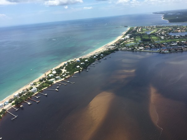
Next up on our Summer of Slime photo tour is a visit to Stuart and Lake O…Stuart and environs is a glistening jewel born of water. It may well top the list of Florida cities in shoreline per capita. There’s simply water everywhere. Two forks of the St. Lucie River, the Indian River Lagoon, canals and peninsulas and islands, and the Atlantic Ocean beyond. Stuart is pictured above; below is neighboring Hutchinson Island.

But it wasn’t Stuart’s reputation for abundant clean water that drew me south from Gainesville with my cameras. In effect, I’ve become a traveling crime scene photographer—and slime is the crime. A devastating outbreak of toxic algae has once again hit the St. Lucie River and the Treasure Coast, fueled by the polluted waters of Lake Okeechobee and the Kissimmee River basin to the north. Damaging headlines trumpet the story to the nation and the world and Governor Scott has declared a state of emergency. It’s déjà vu all over again.

My hosts in Stuart were water blogger Jacqui Thurlow-Lippisch and her husband, Ed Lippisch.

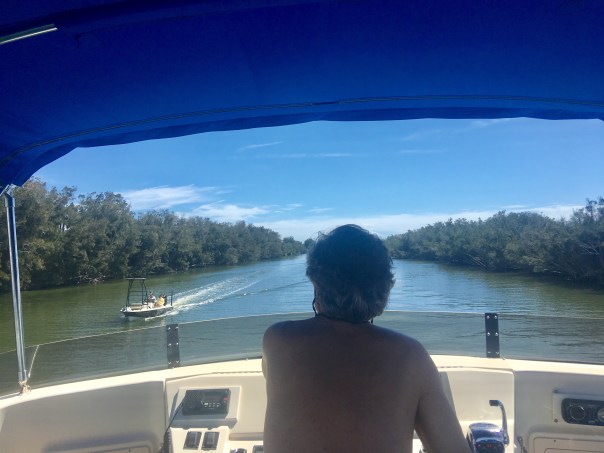
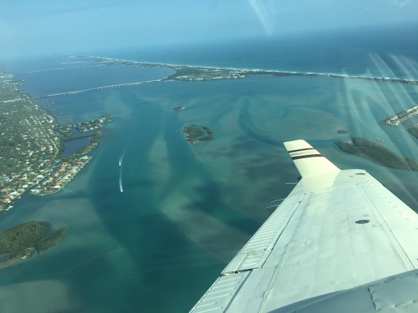
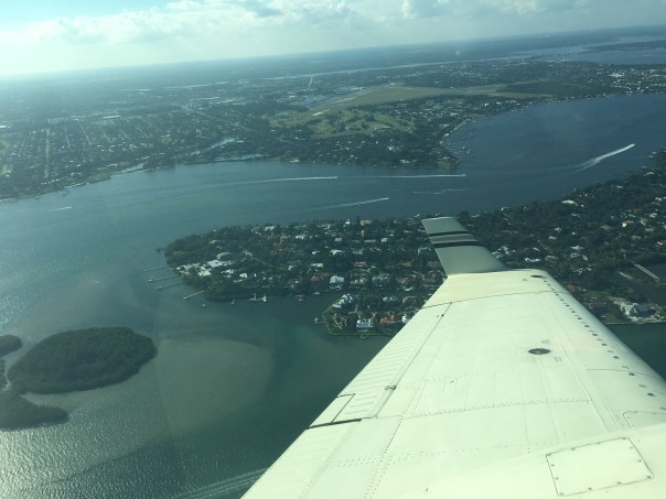
Ed took me up for a photo flight in his Piper Cub so I could get the big picture.

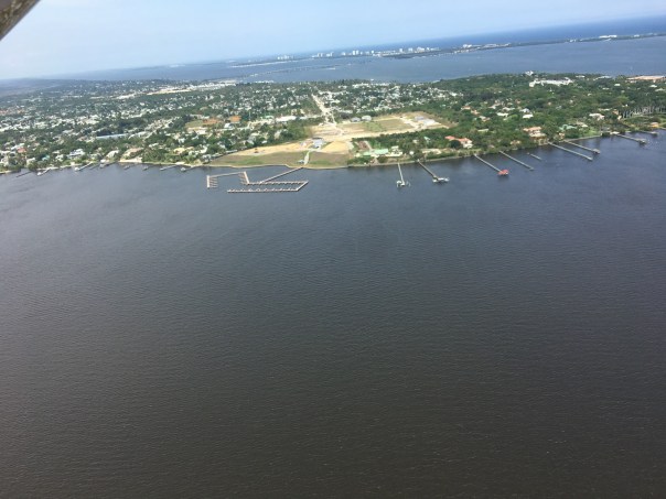
Seen from a small plane at 500 feet, Florida is a beautiful place.

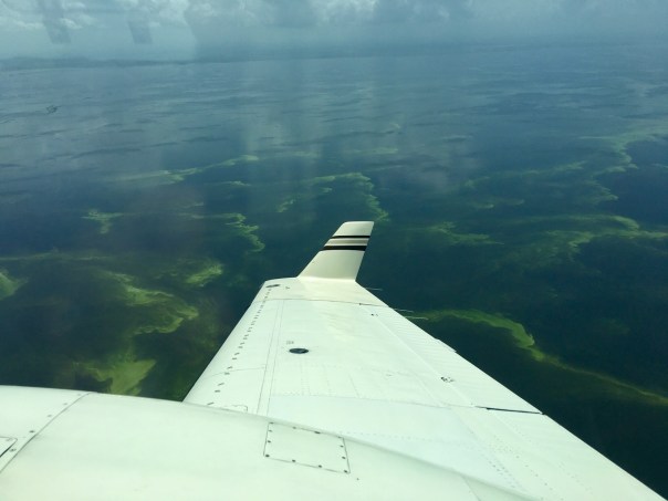
Here’s Lake Okeechobee and the western terminus of the St. Lucie C-44 Canal. Administered by the U.S. Army Corps of Engineers, the Port Mayaca Lock and Dam has the capacity to discharge 14,800 cubic feet of water per second downstream to Stuart and the St. Lucie River Estuary, 26 miles away.

Sugar industry representatives say the water coming out of Lake Okeechobee is not the problem and that the algae outbreak in Stuart is primarily caused by Stuart’s own septic tanks and urban stormwater. This claim is contradicted by the extensive algae mats seen along the C-44 Canal between the Port Mayaca and St. Lucie Locks, well upstream from Stuart.

Lake Okeechobee historically drained south to Florida Bay, not east and west to the Atlantic and Gulf. The C-44 canal was built in 1916 to divert floodwaters to the coast.

A view of the St. Lucie Lock and Dam, several miles southwest of Stuart. On the day of my photo flight in late July, the dam gates were closed, visibly holding back algae from flowing downstream. Look closely and you can see what some people call The Seven Gates of Hell.

The St. Lucie Lock and Dam are an integral part of South Florida’s complex web of water management structures, born of an age when the Everglades was reviled as a watery wasteland and America was driven to drain it.

Below the St. Lucie Lock and Dam, in Palm City and Stuart, you can still find waterfront homes untouched by the algae bloom. But that’s no consolation for the thousands of Martin County residents whose lives are in upheaval once again this summer. The familiar pattern of algae outbreaks is fueled by fertilizer, manure and urban sources of nutrient pollution, including septic tanks.

All of this is compounded by denial and neglect by elected officials and agencies to whom we entrust the important work of environmental protection and public health.

Jacqui Thurlow-Lippisch took me on a driving tour of the C-44 Canal from Stuart to enormous Lake O, which is more like a stormwater treatment pond than a biologically healthy lake. “There are toxic algae blooms across the globe, but only one place where the government dumps it on you: Florida,” she says.

It’s not just the algae from Lake Okeechobee causing headaches along Florida’s east coast; the sheer volume of freshwater discharges is an environmental pollutant that overwhelms the estuary.

The Lake O gunk visible in the satellite view, above, is shown in the detail photo below.

Fishermen are still drawn to Port Mayaca. On the day we visited, I counted nine.

Dinner in hand (speckled perch), Felix Gui, Jr. has been fishing Lake O for 30 years. “The algae doesn’t affect the fish,” he says. “They eat the same, algae or no algae, and I haven’t gotten sick.” Experts have warned against eating fish exposed to the algae.

A Martin County Health Department sign at Port Mayaca warns against contact with the water but I saw no messaging about whether fish caught in these waters is safe to eat.

Enroute home to Stuart, Jacqui and I stopped at deserted Timer Powers Park on the St. Lucie Canal in Indiantown.

At the St. Lucie Lock, a surreal scene of impaired water, above, and a vortex of slime, below, waiting to be flushed downstream.

A pair of jet-skiers signaled for the lock to be opened, and another pulse of algae-laden water is released towards Stuart and the coast.

Wouldn’t want to anyway, thanks.

Further downstream, the algae spreads…

Nearing the coast, Rio Nature Park and the neighboring Central Marine in Stuart are slimed again. This was the epicenter of the infamous Treasure Coast algae outbreak of 2016.

Reporter Tyler Treadway of TCPalm gathered a sample of the polluted water from a canal behind the offices of Florida Sportsman magazine in Stuart.

Staff complaints of headaches, nausea and dizziness prompted Florida Sportsman publisher Blair Wickstrom to temporarily close the office in late July. “It smells like death,” he said.

The Shepard Park boat ramp parking lot in Stuart was nearly empty on the day we visited.

A man on a mission, Mike Knepper, above and below, posts videos on his Youtube channel documenting the degradation of natural Florida.

“It’s totally unacceptable to me what we’re doing to this planet because we’re very rapidly destroying it,” Knepper says. “My children and grandchildren will be paying the price for all the bad decisions we’re making today. I want to be able to look them in the face and say, ‘I tried to make a difference.’”

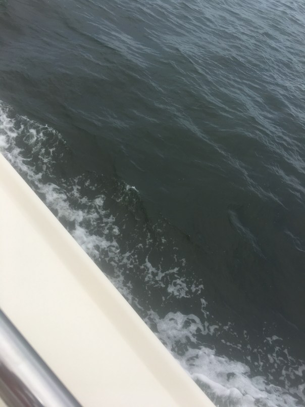
Dead-end canals along the St. Lucie River with their limited water exchange have been hardest hit by the toxic blue-green algae, which scientists refer to as cyanobacteria.

A growing body of medical research links exposure to cyanobacteria with neurodegenerative diseases including Parkinson’s, ALS and Alzheimer’s. Google it.

Meanwhile, we’re getting conflicting messages from officialdom. Martin County has erected signs warning against contact with the water but the Florida Dept. of Health website, under the heading How to Keep Your Family Safe While Enjoying Florida’s Water Ways, has this to say: “Cyanobacteria/ blue-green algae…are naturally occurring in Florida’s environment and are also found all over the world. They are part of a healthy ecosystem and help support a wide variety of aquatic life.” (http://www.floridahealth.gov/environmental-health/aquatic-toxins/cyanobacteria.html) In other words, Lighten up, Florida. This is just nature being natural.

An open question remains: What will become of the value of the Florida brand when the world fully sees what we have done to our waters?

Even in disaster, strange beauty emerges.

Greg Fedele has lived in his water-front home since 1991. He grieves for his loss. “I have three kids who can’t enjoy the waterways of Martin County like I did growing up.”

The sign at Ocean Blue Yacht Sales in Stuart echoes a wide swath of community sentiment. Asked to describe in a word how the algae outbreak has impacted his business, president Bryan Boyd replied, “Horrible. The last three years, our bay boat sales have been a third of what they used to be.”

A roadside sign seen in Stuart in late July. If you’re wondering what you can do about the ongoing crisis of Florida waters, we are called to consider our own water footprint, learn about the issues and get involved. And never forget that elections have consequences. Vote for Clean Water. (https://www.bullsugar.org/#)

What we have here in Florida is not just a crisis of water, we have a crisis of democracy and civic engagement.

From the beleaguered springs of North Florida to the sickened rivers and coasts of South Florida, we must understand that no savior is waiting on the horizon who will fix this thing for us.

It took a group effort to create this mess and we need all hands on deck if are to reclaim our waters. Florida needs environmental patriots willing to face down politicians funded by wealthy interests who think nothing of sacrificing our public waters on the altar of their private profits.

We don’t have the luxury of time to get this right. We are losing our waters now. This is our moment. It’s time to set aside our differences and focus on what is at stake, for this is nothing less than a battle for the soul of Florida.

The pictures don’t lie. We the people of Florida bear witness today to nothing less than a crime against nature, and a crime against the children who shall inherit our natural legacy.

A long time ago, Florida political leaders—Republicans and Democrats in common cause—understood there can be no healthy economy without a healthy environment. They wisely enacted laws and regulatory safeguards accordingly.

But that was then and this is now. It’s time to end the popular fiction in Florida that we can plunder and pollute our way to prosperity.

Gov. Reubin Askew said it best when he declared in 1971, “Ecological destruction is nothing less than economic suicide.”

In this, our Summer of Slime, can I get an amen?

by John Moran
August 2018

web: http://johnmoranphoto.com
email: JohnMoranPhoto@gmail.com
cell: 352.514.7670

Feel free to forward or post this photo essay as you wish; attribution is appreciated. Please share this with elected officials and ask them: what’s their plan to clean up our waters?

Blue-Green Algae Present, Lake O Bloom Subsiding, SLR/IRL


Documenting the discharges, is critical whether by air, on the ground, or from outer space.

The two videos above were taken by me over S-308 at Port Mayaca,  the opening from  Lake Okeechobee to the St Lucie River, and over S-80 at St Lucie Locks and Dam on Friday, July 20th, 2018. The satellite images below, my brother Todd Thurlow provided, were taken the same day.

It is clear that the blue-green algae/cyanobacteria, covering, at its height, 90% of Lake Okeechobee, has run its course and bloomed. Now, as the “flower falls,” we see what’s  left.

As seen in the aerials, and what the satellite images cannot portray, is that the algae is still there just lessened. Flying out over the lake a light green algae film remains over the water, a pastel shadow of its once flourescent self.

7-20-18, light colored algae, Lake O off eastern shoreline, JTL

The seven aerials at the end of this blog post were taken by my husband, Ed,  this afternoon, July 22, 2018 around 4pm. The tremendous green shock is gone, but squiggly lines of nutrient bubbles remain, and blue-green algae visibly lines the eastern shoreline to be sucked into the gates…

Will another gigantic bloom arise? Another flower to replace the dropped blooms of yesterday? Only time shall tell…

One thing is certain. Nutrient pollution (Phosphorus and Nitrogen) is destroying Florida’s waters, and unless non-point pollution, especially fertilizer runoff from the agriculture community, is addressed, faster than Florida’s Basin Management Action Plan requires- pushed out 30  or more years, we are will be living with reoccurring blooms indefinitely.

A great book on this subject is Clean Coastal Waters, Understanding and Reducing the Effects of Nutrient Pollution, National Reaseach Council 2000, https://www.nap.edu/catalog/9812/clean-coastal-waters-understanding-and-reducing-the-effects-of-nutrient

Read below how Florida is trying to fix its impaired waters; nice try but no urgency. As we all know, there is no time to wait.

Florida Dept. of Environmental Protections Basin Management Action Plan: https://floridadep.gov/dear/water-quality-restoration/content/basin-management-action-plans-bmaps


Sentinel-2 L1C, SWIR on 2018-07-20.jpg 1,638×1,637 pixels, courtesy of Todd Thurlow. Visit his site here: http://www.thurlowpa.com/LakeOImagery/%5B/

Sentinel-2 L1C, True color on 2018-07-20.jpg 1,668×1,668 pixels, courtesy of Todd Thurlow. Visit Todd’s site here: http://www.thurlowpa.com/LakeOImagery/

Ed Lippisch S-308 at Port Mayaca, the opening form Lake O to C-44 Canal and SLR, 7-22-18

Ed Lippisch 7-22-18

Ed Lippisch 7-22-18

Ed Lippisch 7-22-18

Ed Lippisch 7-22-18

Ed Lippisch 7-22-18

Ed Lippisch 7-22-18

Timely quote for thought by the late Mr Nathaniel Reed 1933-2018

“…The fact that the Department of Environmental Protection and the Everglades Foundation have at last identified every polluter in the vast Okeechobee headwaters is an astonishing feat. The sheer number of polluters is mind-boggling.

The failure to enforce the possibly unenforceable standard (best management practices) shines through the research as testament to the carelessness of our state governmental agencies about enforcing strict water quality standards within the watershed.

There is not a lake, river nor estuary in Florida that is not adversely impacted by agricultural pollution.

As one of the authors of the 1973 Clean Water Act, I attempted late in the process to include agricultural pollution in the bill, but the major congressional supporters of the pending bill felt that by adding controls on agricultural pollution the bill would fail.

Now, 54 years later, fertilizer and dairy wastes are the main contributors to the pollution of the waters of our nation. Algal blooms are all too common even on the Great Lakes.”

Excerpt, Letter to the Editor, Stuart News, 2017

A Tear for Lake Okeechobee, SLR/IRL

Ed and I have just returned from vacation. Ironically leaving June 28th, the day the ACOE announced a nine-day reprieve due to algae in Lake Okeechobee; and returning July 8, the day before the ACOE may open S-308 into the St Lucie River once again.

It was a great trip and the weather was excellent.

Ed was our pilot, and we flew with stops from Stuart to Michigan. It was remarkable to sit in the airplane and see the land below me ~ever changing from swampland, to farmland, to cites, to forest, to mountains, to rivers, and peppered with hundreds of lakes….

When we finally approached the Great Lakes Region, I was looking for the algae I had read so much about, and yes, there were some lakes turned green. But not in the vast northern waters of Lake Michigan, or Lake Huron, these lakes were deep mirrors of blue.

“The water here looks like the Bahamas,” Ed noted. We both looked in wonder at their hue.

Sometimes, I awoke at night, thinking of home. Thinking about how there is nothing like it, in spite of the many wonders of our great county. In spite of the beautiful, blue, icy waters of Lake Michigan.

On the way home to Stuart, I asked Ed if we could fly inland over Lake Okeechobee just to see.  It was midday and the clouds had popped up and I knew we’d have to do my least favorite thing, fly though them. As the turbulence engulfed the airplane, I closed my eyes and prayed. And then finally, as always, we were through.

The lake opened up before us like an ocean.

I could clearly see the algae at about three thousand feet. It was visible roughly a mile off the lake’s east coast out into the lake for as far as the eye could see. Ed flew west and then circled around. The green masses of algae had been pushed into geometric designs by the wind, and they were everywhere. We flew for miles over the middle of the lake and beyond. To my surprise, the repetitive, endless, formations of cyanobacteria caused something unexpected to happen. Rather than my usual disgust, or anger for the destruction of the St Lucie, I felt myself begin to tear-up. “This poor lake,”  I thought to myself. “I know you were once so beautiful even mythical;  what have we done to you?

Just unbelievable…”

I wiped the tear from my eye, so sad for what is happening to the waters of my beloved Florida. Ed turned the plane, and we headed home…

S-308 algae was visible about a mile off the east coast of the lake and on and off, sometimes heavy, inside of the S-308 structure and in the C-44 canal to S-80 at St Lucie Locks and Dam.

S-80 was open and algae could be seen going through the gates  from the C-44 canal

Home at last. Sewall’s Point Park River Kidz FDOT recycled sign art

All photos take on July 7, 2018, 3pm. JTL/EL

Masses of Algae Pressing the Gates; Will ACOE Discharge Tomorrow? SLR/IRL

6-24-18, (Sunday)

I am posting this, not because I want to but because I have to. I much rather be enjoying the day instead of once again sitting at my computer. But time is of the essence.

This morning I read a comment by TcPalm reporter, Ed Killer, on Facebook stating the ACOE’s pulse release schedule for the St Lucie River.

Ed KillerThe Corps gave me this today

Sat- 0
Sun- 0
Mon- 1270 cfs
Tues- 2000
Wed- 2100
Thu- 1650

If this is true, and with Ed Killer posting, I believe it is, the ACOE will start releasing again Monday, 6-25-18. I did not know this until I read his post.

Today, my husband Ed and I were flying other people over Florida as usual, and during our flight I took this video expecting maybe some algae in C-44 but instead also found the gigantic bloom against the gates of S-308 in Lake Okeechobee leading into C-44/SLR.

So I wrote on Facebook:

I am so over this, but cannot fail to report. According to Ed Killer ACOE will start discharging from Lake O tomorrow in spite of Governor’s Emergency Order. Look at this algae mess waiting at gates of Port Mayaca. Write ACOE’s LTC Jennifer Reynolds and politely ask for ACOE to wait and to have DEP test again: jennifer.a.reynolds@usace.army.mil (JTL-S-308 video taken 6-24-15 at 12pm) #toxic2018

As Monday is tomorrow, and I fly to DC with the River Kidz tomorrow, I am posting this now. I truly believe considering the circumstances, that the ACOE should refrain from discharging at S-308 or S-80. And the state’s FDEP (Florida Department of Environmental Protection) should have this water tested, again, as bloom has changed.

To just dump this on the people of Martin County along the St Lucie River is a crime.

Respectfully,

Jacqui

PLEASE WATCH THE VIDEO

The recognizable shape of S-308 the entrance to C-44 and the SLR. Lake O’s connection to the river—obvious massive algae bloom at gates.

Bloom as satellites show is throughout and scattered in lake. This shot is looking more towards middle of lake in southern area.

Entrance to Caloosahatchee on west side of lake and near Clewiston Bloom is all through lake.

Brian Mast, Even More than a Congressman of His Word, SLR/IRL

It takes a lot for me to trust a politician, probably because at times, I’ve been one myself…

In 2016, when I was running for District 1, Martin County Commissioner, I met Brian Mast. We were both standing on the side of Martin Luther King Boulevard,  with our teams, holding signs in near 100 degree heat and off the chart humidity. There is always time to wipe the sweat off your brow and talk, when no cars are driving by…

Of course, Brian is a striking person, no matter the case, but when he told me the St Lucie River’s health would one of his priorities, although pleased, ~because I had heard that many times only to lead to disappointment, I was doubtful. Only Senator Joe Negron had ever won my full loyalty for his commitment to the river.

Well, by tremendous fate, Joe Negron’s legacy is being pushed, most outstandingly, now by Congressman Brain Mast. Brain’s consistent record for the river, since being elected in 2016, cannot be matched congressionally by anyone else in office at this time.

His two recent letters to the Honorable R.O. James, Assistant Secretary of the Army on June 7th, and yesterday’s letter, dated June 14th, 2018, to LTG Todd Seminole, Commander General of the US ACOE, are unparalleled in direct, passionate, and respectful communication regarding the damaging algae releases from Lake Okeechobee to the northern estuaries, These are game-changer letters, that will be documented, and referenced in the archives of Washington DC building our case for years to come.

I commend Congressman Mast; I thank him for not only keeping his word, but exceeding  expectations. He is more than a soldier of his word, he is am American, and a St Lucie River hero. And he must be reelected.

Please read both letters below.

JTL

Brain Mast’s website: https://mast.house.gov

Meeting with C. Mast with EF in April 2018

Mast’s War Board for the SLR

Toxic Algae 101, Watching it Turn Toxic, SLR/IRL

St Lucie River looking across from Central Marine to Martin Health.

Mary Radabaugh called me this morning.

“Jacqui, get dressed and come on over here to Central Marine! It’s happening again, and this time there are logs, algae logs. I have never seen this before.”

since May 23rd, Mary and I had been exchanging photos of the water in the St Lucie River at the marina she and her husband have managed for many years. The marina that brought national toxic algae coverage in 2016. The marina that the SFWMD and DEP did core samples of river bottom in 2005, but have been quiet since. The marina that is the ground zero of zeros…

So I got dressed and headed over.

The waters have slowly been changing, worsening since the C-44 basin waters opened into the river  about March 15th. And Mary has documented this change on her Facebook page. After June 1st, when the ACOE opened S308 to discharges of Lake Okeechobee, things have sped-up and are starting to crescendo.

Only three days ago the waters of the St Lucie River were primarily a dark cloudy coffee brown sometimes with little specs. Then as winds and tides push the specks and foam in the river into the pocket of the marina, the now green specks of particulate start to organize. It is incredible to see that just from yesterday, to today, the algae has bloomed in bright fluorescent green slicks. In 2016, this happened all over the river, primarily in marinas, coves, along shorelines, against dock pilings and any other place the forever thickening algae would get “hung up.”

It is happening now too, but not as extreme. Yet.

This all happens because over the past 100 years the St Lucie River’s basin has been expanded tremendously, erroneously, taking on developed-land’s, and agricultural canal water (C-44, C-23, C-24) that pollutes and turns the brackish estuary fresh. Once the canals have almost killed the river, then the ACOE opens the gates of Lake Okeechobee without even checking the water quality from the SFWMD, or better yet, the Department of Environmental Protection (DEP). Just let ‘er roar!

This time, as was the case in 2016, an algae bloom in the lake is being transferred into the river through C-44. This is totally obvious with arial photography. The blooms start in the lake.

But since the river is now fresh, from all the canal  water, the microcystis  algae coming and once living in Lake O can live here too, and bloom toxic…

That the federal and state governments do this to their own people is mind-boggling. I know there are many water bodies around the county with algae issues, but we are certainly the only place in America where the government is knowingly dumping it on to a community of people.

There have been many opportunities over the years to fix the situation, but no, pure crises of the past few years is necessary before considering a fix….yes and thank God the EAA Reservoir is on the horizon. We must hold fast!

Today, I am sharing the photos of the Central Marina algae and its blooming.

Tomorrow  we shall see what else it brings….this algae has not been tested yet, but one thing is for sure, if history repeats itself, it surely will be toxic.

In closing, be sure too to watch the poor manatee eating the algae off the seawall. Having survived millions of years as a species, he or she certainly deserves better.

TIMELINE TWO DAYS

Tuesday, June 12, 2018 7:58 AM

By afternoon it was swirling into designs.

Tuesday, June 12, 2018 2:59PM

And then by today, it was filling in those shapes with fluorescent green.

Wednesday, June 13, 2018, 8:30 AM

Wednesday, 6-13-18, 2:02PM

#toxic2018

Report Your Algae Sighting to DEP, Overwhelm Them, SLR/IRL

I, as many, have seen and received multiple algae reports via Facebook, text, and through the tremendous reporting of Tyler Treadway of  the Stuart News. Now, I am encouraging everyone to take the time, and it doesn’t take much, to report their algae sightings in the St Lucie River/Indian River Lagoon to the Florida Department of Environmental Protection, (DEP).

It was Mike Connor who reminded me to do this, after my husband Ed accidentally spotted the algae lines by plane off Port Mayaca ~in Lake Okeechobee~ on June 2nd, the day after the ACOE started discharging.

At first I thought, “I’m too busy for that…” and then I realized of course I need to report to DEP because then the state is obligated to document and to test it for toxcidity.

Better yet, if everyone who is reporting via social media and text called DEP, there would be so many test sites for DEP to test, it would exhaust their resources.

Oh well…

Since our resources are gone, this is only fair.

As they say: “All is fair in love in war.”

Please report algae  sightings; see link below.

If you can’t figure it out this unclear website, call the Governor’s office: 850-488-7146 or Noah Valenstein the head of DEP: 850-245-2118.

Jacqui

https://depnewsroom.wordpress.com/south-florida-algal-bloom-monitoring-and-response/

Off of Overlook Drive near downtown Stuart. A beautiful location, an area Ed and I considered building on.

Liz Dunn shared 6-9-18 just south of Martin Health System.

Documenting the Discharges, June 2018, SLR/IRL

When the St Lucie River/Indian River Lagoon start to deteriorate due to discharges, things start going downhill fast. And when my husband Ed and I start taking and sharing aerial photos, my world becomes a bit chaotic.

Sometimes there are days of hundreds of photos to look through, and knowing the importance of getting them out immediately, choices have to be made. Facebook is a better medium than my blog for real-time info as it takes less time, but my blog is better for historic documentation as it is “permanent.”

So today I am sharing more of Ed’s photos from 6-5-18, and some you may have already seen. Mind you, after heavy rains, stormwater has been pouring in from many canals but, always, like clockwork, after the ACOE starts discharging from Lake Okeechobee, the river looks not just cloudy-coffee brown, but contaminated.

The ACOE started discharging from Lake Okeechobee on  6-1-18, and as most of you know, now, there are not only algae blooms spotted in the lake, as Ed accidentally found on 6-2-18, and others also documented, but also in the St Lucie River. More than likely, there will be more and more  algae bloom popping up as the Lake O water makes its way down the estuary, over the tip of Sewall’s Point, towards the St Lucie Inlet. Algae floating down the river is disgusting enough, but toxicity is the real question…

Ed and I will take and share more aerials  in the future, to document the algae blooms should they explode, but until then, here are some photographs from 6-5-18 that I had not yet archived on my blog. Sadly enough, although there is no algae in these pictures, I cannot say they will make you feel any better.

Never take the pressure off politicians to build the EAA Reservoir and get it to where it needs to be to clean and filter this water to send south as Nature intended.  Government knowingly contaminating its citizens is not an option. Health, Safety and Welfare is a responsibility.

Photos taken 6-5-18 showing SLR/ILR near Sewall’s Point; Jupiter Narrows; Atlantic Ocean/beach over nearshore reefs along Jupiter Island just south of St Lucie Inlet; out in ocean near Peck’s Lake; Sailfish Point/Sailfish Flats area; and Bird Island, a Critical Wildlife Area, for many threatened and endangered birds.

SLR on west /IRL on east – looking towards Sewall’s Point

Jupiter Narrows near St Lucie Inlet

A Coffee Ocean along Jupiter Island just south of St Lucie Inlet

Discharges in waves looking east to Peck’s Lake

Discharges going over near shore “protected” reefs

Discharge plume

Plume out about 2 miles in Atlantic/documented at 5 over days by fisher people

Similar photos give felling of flying over

Reefs with plume coming on

Selfish Point and Sailfish Flats area one the “most biologically diverse in North America.” Seagrass is gone due to receptive discharges episodes

Circling home- close up souther tip of Sewall’s Point

Again circling ove Sailfish Flats on way back to Witham Field.

Bird Island just off of southeast Sewall’s Point is home to hundreds/thousands of birds. Many threatened and endangered species raise their young on this island that was designated a CWA or Critical Wildlife Area by FWC in 2014. At the time it was the first to be designated in 20 years.

The Algae Comes From the Lake, Documenting the Discharges, 2018, SLR/IRL

Since my husband, Ed, accidentally spotted an algae bloom in Lake Okeechobee, while running new engines on the Baron, I have posted many photos on Facebook and the word is out.

Nonetheless, for purposes of documentation, I am going to post some of the photos again on my blog for historical purposes and for those who do not use Facebook.

~Ed noticed the “lines of algae” in the lake on June 2, two miles or so northwest of Port Mayaca, the day after the ACOE started discharging from Lake O into the St Lucie River. Absolute chance, fate, or a tip from above, however you decide to look at it.

Since this time others have documented on the ground and DEP should be testing for toxicity.

So, after seeing the bloom on Friday, Ed went back the following day on Saturday in windy conditions so I stayed home–in the yellow plane, the Cub, getting more pictures of bloom, looking about the same but more dispersed from rain perhaps. These photos at lower altitude also include drainage structures around the lake, as well as the destruction of the St Lucie River/Indian River Lagoon at Sewall’s Point and the St Lucie Inlet.

Photos will continue to be taken as we once again, document the discharges, and once again have seen first-hand, like we did in 2016, without the warning of our government, that the algae that contaminates the St Lucie River starts in Lake Okeechobee.

Saturday, June 2, 2018

Sunday, June 3, 2018

Stuart on the St Lucie River, Great Old Inlet Photos, 1937 Stuart Daily News

Page 10, historic Stuart Daily News, Special Edition 1937, in celebration of the Stuart to Ft Meyers Cross State Canal courtesy Knight A. Kiplinger

We are up to page 10 in our history lesson and today’s photos are some of my favorite. The first is an aerial of the St Lucie Inlet entitled “Stuart on the St Lucie River.” Since its earliest day’s, Stuart has always been defined by its proximity to the river.  Below the aerial it boast: “World Famous For its Fishing, Provides an Ocean Entrance for Small Craft.” And by today’s standards, a rather comical or un-comical plug can’t be missed: “Where the Waters of Lake Okeechobee Meet the Atlantic.”

It is also fascinating to note the shape of the south side of the St Lucie Inlet as today it has shifted and filled in. I am sharing my brother’s Time Capsule Flight used in former posts as it is so interesting and shows the various inlets of this area and land shapes as documented on various historical maps. Although today, we try to make barrier islands, beaches, and inlets permanent, by watching my brother’s video the message is clear: “the only constant is change.”

Todd Thurlow’s video Changing Inlets of the Southern Indian River Lagoon: (https://www.youtube.com/watch?v=ZhYQz4P1ELM&list=PLDaNwdmfhj15bmGNQaGhog9QpkQPAXl06&t=20s&index=2)

Shifting Inlets: https://jacquithurlowlippisch.com/2015/10/28/flight-over-the-shifting-inlets-of-hutchinson-island-1515-1900-st-lucie-riverindian-river-lagoon/

St Lucie Inlet: https://jacquithurlowlippisch.com/tag/dredging-costs-st-lucie-inlet/

“The St Lucie River Estuary Leading to Stuart, Six Miles upriver. Here, at Sewall’s Point in the Foreground, Is the Junction of the Intracoastal Waterway and the St Lucie. Stuart Bridge in Background.”

Intracoastal Waterway:https://en.wikipedia.org/wiki/Intracoastal_Waterway

It is also fun to compare  the aerials of Mr Lowell Hill, 1937 above with this one below dated 1952 by Arthur Ruhnke and Google Earth of 2018.

Courtesy of Sandra Thurlow

1937 Ads, Stuart Daily News, Commercial Fishing, Taverns, Progress! SLR/IRL

1937 Stuart Daily News, courtesy of Mr Knight A. Kiplinger.

Yesterday, I transcribed an historic article by Edwin A. Menninger written in the Stuart Daily News‘ special edition dated February 27, 1937. This rare find, shared from the library of Mr. Knight Kiplinger, was published in celebration for the opening of the Stuart to Ft Meyers Cross-State Canal.(https://jacquithurlowlippisch.com/2018/03/28/ironic-insights-the-dream-of-floridas-cross-state-canal-by-edwin-a-menninger-stuart-daily-news-1937/)

Today, we will open this exceptional document and see what’s inside,  on page two…

There are five ads on the page. Each one is a peek into history, and for me the final ad from the commercial fishing industry is the most interesting! But first, let’s look at the left hand top of the page.

There is an ad for The English Tavern, south of the Roosevelt Bridge, that welcomes the yachtsman; with ample parking space. This sounds like fun! Why wouldn’t there be ample parking in 1937. 🙂

To the right of that is an Enjoy Sailfishing in the Gulf Stream ad. It ask you to write, wire, or Phone 47-J for reservations. (Note today we have a three-figure area-code and six numbers!) The ad notes: Marine Ways Storage; Marine Supplies Repairs; and Boat Building at Toley’s Boat Yard, Salerno. (Ironically the grandson of Toley, Shawn T. Engebretsen, is my husband’s oral surgery business partner!)

The next ad, on bottom right, is from Stuart Metal Works where one can investigate the opportunities for building in the beautiful St Lucie River Region, Phil Pence, Proprietor. “Plan to make your home in the yachting wonderland!”

And the last of the foursome, in bottom right, is an ad by the Fort Pierce Financing and Construction Co.,  208 Orange Avenue, Fort Pierce, stating that “Completion of the Cross-State Waterway is a mark of progress for South Florida.” (People of that era loved this word “progress,” and my mother still uses it!)

~Like when I was a kid, I  would see a mowed down forested area made for a parking lot and she would say: “It’s progress honey!” 

And last, but not least this insightful ad from the Commercial Fishermen’s Industry of Martin County that reads below a gigantic every-day catch of that era, a gargantuan pile of speckled sea-trout:

“The Commercial Fishing Industry of Martin County, Producing an Annual Revenue of More Than $1,00,000, Requests The Cooperation Of Officials On Charge Of The Lake Okeechobee Project To Maintain Discharge Of Fresh Waters From St. Lucie Canal At A Minimum During The Fishing Season From November To March.” 

If you had the time to read yesterday’s blog,  Edwin Menninger’s article stated that “Construction of the St Lucie Canal began in 1921 when the fact dawned on the Everglades pioneers that canals through muck lands were useless – they refused to carry water out of the lake. Four of them had been dug, and were utterly worthless. The St Lucie was completed in 1924 and for 13 years has been the ONLY functioning outlet from Lake Okeechobee to the sea.”

Attached is a 1909 map of South Florida from the 1909 State of Florida report “Report on the Drainage of the Everglades of Florida, By J. O. Wright, Supervising Drainage Engineer”. (Not in article but for reference)

The concerns of Stuart’s nationally recognized and often President-visited waters are well documented in my mother Sandra Henderson Thurlow’s book Stuart on the St Lucie. Nonetheless, I never knew that from approximately 1924 to 1937 the St Lucie canal, today’s C-44, was the only outlet  for Lake O. Yikes!

The wonderful thing about history is that there is always something to learn!

To be continued….

Jacqui

My God, What Have We Done? St Lucie River/Indian River Lagoon

Frances Langford Estate in Rio/Jensen Beach Florida ca. 1960s. Courtesy of Sandra Henderson Thurlow, Thurlow Collection.

You know, I hate to be a broken record from the past, and I know the rules. Fights  should lie dormant after they are fought, and won, or lost….

But I just can’t help myself…

Recently my husband Ed and I received a postcard in the mail advertising Langford Landings’ Grand Opening on March 10th, 2018.

It made me so sad to see this card. It looked like an ad from Rooms to Go.

I just don’t see how we as a county allowed such a tropical, historical piece of property to go to the “cookie cutter mill.”

Albeit the homes are expensive, pretty, and modern, they have no character of the original famed, Frances Langford Estate. None. Scraping all the trees off  the land was the greatest sin,  as these modern homes could look more tropical, more Frances Langfordish, if they had left some of the stately trees that she planted.

Yes, the developer “did not break any rules,” but we did, the Martin County Commission did. The rule broken? To show respect and honor to those who have walked before us. Especially, Mrs Langford.

Photos speak a thousand words.

Below are many from my mother, historian Sandra Thurlow, and Facebook friends, Bobbie Blodgett, and Rebecca Fatzinger. Local, Pop Delancy and others. People who shared with me as the property was be cleared and dismantled beginning in 2015…

Well anyway. To broken records! “Long live the grace, beauty, and spirit of Mrs Frances Langford!” (I’ll Be Seeing You: https://www.youtube.com/watch?v=Dok70bgFXHw)

2015 Clearing as seen from Palmer Road and Present 2018 Post Card Sent Out Recently For Grand Opening of “Langford Landing,” the former Frances Langford Estate

Chose a floor-plan/home “Langford Landing” website 2018: https://www.meritagehomes.com/state/fl/south-florida/langford-landing#gref


Historic Photos Frances Langford Estate

Frances Langford

Frances Langford in her later years stands before photos decorating the Francis Langford Outrigger Resort. Her home was across the street on 53 acres she turned into a tropical paradise. (Public photo)

Langford Landing Website, Meritage Homes 2018: https://www.meritagehomes.com/state/fl/south-florida/langford-landing#gref

Earlier post on subject: https://jacquithurlowlippisch.com/tag/the-former-frances-langford-estate/

Don’t be Fooled by Beauty; Our Barren River… SLR/IRL

My husband, Ed, took these photos of the Indian River Lagoon at the St Lucie Inlet on 2-28-18, just a few days ago. They are certainly beautiful enough to sell real estate…The turquoise water is so pretty one could easily overlook the sand desert below the surface waters.

Enjoy the blue water, but know that especially since 2013, our seagrass beds have been decimated by black sediment filled waters and toxic discharges from Lake Okeechobee. Seagrasses are the nursery for all sea life, especially the baby fish. These beds need time to reestablish if they ever will.

True beauty has something to offer, not just “surface water.” Keep your eye on the lake and fight against any coming releases this summer so we can get life back in our dear dead river.
 

Lake O level, ACOE: http://w3.saj.usace.army.mil/h2o/currentLL.shtml

The Importance of Seagrasses, FWC: http://myfwc.com/research/habitat/seagrasses/information/importance/

Twilight Flight Over the St Lucie River, SLR/IRL

Last night’s twilight flight was a first for me, but not for my husband Ed. Usually, we fly in daylight chasing algae blooms or black Lake Okeechobee water…

Last night was just for fun, but one still feels the pull to protect this sacred place.

The beauty of the lands lighting up beneath us was almost as inspiring as the sunset. Humanity, such promise.

We do live in a beautiful place. A place to protect and call home…

Toxic Beauty, SLR/IRL

Growing up in Stuart in the 1970s, my mother and father gave me full reign to explore the undeveloped lands in the area of St Lucie Estates. I remember endless summers, wandering around in “the woods” and of course my eyes were drawn to the vine of the widely dispersed, perfectly shaped, red and black seeds known as rosary peas.

I would collect them tightly in my little, sweaty hands, pushing them far down into my pockets. I recall the first time I brought them home, my mother said, “Yes, they are very pretty, but don’t eat them, they are poisonous.”

“Hmmm,”I thought. “How can something beautiful be poisonous?”

I continued to collect the seeds, and over the years filled up many clear glass bottles that sat in my window sill; the sun never fading their brilliant color.

Later in life, I learned that bright color patterns, especially red, black, and yellow, as with some caterpillars, or the famous, shy, and deadly coral snake, are “warnings” in nature and actually provide the animal with protection from being eaten.

As I walk through Hawk’s Bluff today, I am thankful to my parents who allowed me to explore the natural world and grow confident, unafraid, even with all of its toxic beauty.

Hawks Bluff Trail

Rosary pea, known many other names: https://plants.ifas.ufl.edu/plant-directory/abrus-precatorius/

Colors in Nature: http://flnps.org/color-nature

Documenting the Discharges 12-27-17

I guess one could say the St Lucie River is getting a new year’s present in that yesterday was the last scheduled release from Lake Okeechobee by the Army Corp of Engineers. The entire situation has a similar theme to an abusive relationship where the beaten thanks their oppressor for finally halting…

Therefore, I will not say “thank you.”

http://www.saj.usace.army.mil/Media/News-Releases/Article/1402349/corps-transitions-to-lower-flows-from-lake-okeechobee/

http://www.saj.usace.army.mil/Media/News-Releases/Article/1402349/corps-transitions-to-lower-flows-from-lake-okeechobee/

Due to Temporary Flight Restrictions (TFR) because of the President’s visit to Palm Beach, it was not possible to fly south along Jupiter Island from Witham Field in Stuart, however, when the wind and runway changed my husband, Ed, was able to get a few aerials at the Crossroads of the St Lucie River and Indian River Lagoon around Sewall’s Point. No seagrass, but the water already looks better.

After being decimated in 2013; part of 2015; toxic in 2016; and experiencing a no-holds-barred discharge rate since September 20, 2017, post Irma; we will continue to fight for the EAA Reservoir’s success and a better 2018 for our St Lucie River.

We shall never, never, never, give up!

Please see links to my brother Todd Thurlow’s website for St Lucie Canal Real Time Flows S-80 Cumulative 2017 and Latest Lake O Satellite Imagery

http://www.thurlowpa.com/LakeOLiveData/2017/

http://www.thurlowpa.com/LakeOImagery/LakeO3x7days.html

http://tfr.faa.gov/tfr_map_ims/html/index.html http://tfr.faa.gov/tfr_map_ims/html/ns/scale5/tile_14_15.html http://tfr.faa.gov/tfr_map_ims/html/ns/scale6/tile_28_29.html

All photos of SLR/IRL by Ed Lippisch 12-27-17

ACOE data is for previous weeks. Obviously the St Lucie gets enough redirected and area runoff without Lake O. ACOE 12-21-17

End of Year Water-Warrior, A Humpback Whale! SLR/IRL

Pinterest image, uncredited, 2017

As the year 2017 comes to a close, we had a special guest sighted in our offshore waters. On December 17th, a Humpback whale was seen breaching in the Atlantic off of Stuart!

Although these mammoth creatures do migrate, and thus navigate our seas, this is a special and rare site.

Perhaps this is time for reflection…

Just as with the Biblical story of Jonah and the Whale, the Native People also give whale sightings and experiences special significance.

According to native lore, “whales visitors/spirits were used to convey a message of power and might, representing the need for strong, silent deliberation.”

Native Images, whales

In the story of Jonah, having turned away from responsibility, and being thrown as “bad luck” from a ship, Jonah is swallowed by a giant whale, reflects, repents, is renewed, is given a second chance, is ejected, and fulfills his responsibilities….

Perhaps there is a lighter message from our visiting whale, like “Happy Holidays,” and “Merry Christmas,” or a fun breach-splash saying “Yahoo! Keep up the fight for clean water!”

For me, the whale visitation made me reminisce on Ed and my visit to Baja, in 2013, to visit the Grey Whales once slaughtered, and now a great tourist attraction, and how this experience of seeing these huge mammals adapt to our human world, especially the mothers with their calves,–the controversy, and alteration in both human and whale actions—– changed my life, and my outlook forever.

Grey Whales, San Ignacio, Baja, 2013 Mexico https://www.nationalgeographic.com/photography/proof/2017/08/gray-whales-baja-mexico/

Saying hi to Grey Whale

Baby Grey Whale encouraged to visit side of boat by its mother

In any case, the season is upon us and I am grateful for all of the work done this year for our waters and for our Florida. Thank you River Warriors! Thank you Bullsugar! Thank you Captains for Clean Water! Thank you people of Florida! Thank you President Negron! Thank you all, so many others across our great state! And in closing, thank you visiting whale!

Sometimes it is hard to stay motivated,  but like Winston Churchill said: “Never Give Up.” Our work is so important!

…Yes, in 2018, in spite of the difficulties, we will continue to be the strong, silent or screaming giant that dominates the conscience of Florida…

Humpback whale, Stuart, Dec 17, 2017

Watch TCPalm video here: http://www.tcpalm.com/videos/news/local/martin-county/2017/12/18/video-humpback-whale-sighted-off-shore-near-stuart/108725684/

Video credit:
Mattanza Charters, based in Pirates Cove Resort and Marina in Port Salerno, posted video taken Sunday, Dec. 17, 2017, of humpback whales breaching near Eight Mile Reef in the Atlantic. VIDEO PROVIDED BY CAPT. MIKE MURRAY Wochit

—————————–

http://us.whales.org/species-guide/humpback-whale

Whales in Art, Literature and Mythology

Jonahs Whale

Documenting the Discharges, 12-4-17, SLR/IRL

12-4-17, ca. 2:45 pm, photos: Ed Lippisch & Jacqui Thurlow-Lippisch

The Army Corp of Engineers has lessened but not stopped Lake O discharges that started September 20th, 2017 just prior to Hurricane Irma. Perhaps as the discharges have gone on at such a high rate for a comparatively long time,  the plume has had a chance to extend its territory. In yesterday’s photos, the dark, filthy plume is reaching clearly south beyond the exclusive Town of Jupiter Island.

Yesterday was a beautiful day, but the river and ocean waters of our entire region were ugly, possibly contaminated. How are we to enjoy our property and lives here?

When viewing the aerials below, please note the blue, sapphire-colored water just on the edge of the discharge plume. Yes, of course all estuaries put forth darkened fresh water after a rain event, and Ed and I could see this occurring just south at Jupiter Inlet. Nonetheless, the black, gigantic plume that we repeatedly endure for the St Lucie River/Indian River Lagoon due to discharges from Lake Okeechobee is an aberration.

Please let’s all  support Joe Negron and the public’s work to build the EAA Reservoir; clean & send the water south!

Lake O discharges: http://w3.saj.usace.army.mil/h2o/reports.htm

Looking south along the southern most area of Jupiter Island.

Looking north along Jupiter Island-dark ocean waters. Jupiter Narrows an extension of the IRL on left.

Plume -looking north along Atlantic coast

Edge of plume; note clean sapphire colored water juxtaposed to dark Lake O/canal plume

Another angle, Jupiter Island,  looking south-blur due to wind and camera movement

Back at St Lucie Inlet

IRL, note bare bottom. This area is known as the Sailfish Flats and once had hundreds of acres of seagrass beds.

The Sandbar, a popular weekend recreational area for boaters, especially families, surrounded in dark Lake O discharge waters. This is a health issue.

Barren Sailfish Flats

Sand bottom with no seagrass between Sewall’s Point and Sailfish Point. An area once teaming with life.

The Crossroads — no seagrass beds just sand bottom

IRL looking north

St Lucie River near St Lucie Inlet dark as coffee

North of St Lucie Inlet the plume covers near shore protected reefs as it does south of the inlet.

Blue!

The plume as viewed from under the wing of the Cub

Plume edge: The tainted water we are given by our government; the blue –the water we should have by God & Nature.


Documenting the Discharges 11-19-17, SLR/IRL

Last Thursday on November 16, the ACOE reported they will reduce the amount of water they are releasing from Lake Okeechobee. The Corp had been releasing at a high rate, on and off, since September 20th. New targets are 2800 cfs east and 6500 cfs west.

Photos below were taken yesterday, 11-19-17 by my husband, Ed Lippisch. We will continue to document the discharges from Lake O, and area canals.

As Thanksgiving approaches, we are thankful the discharges are lessened and that the SFWMD and the public are working hard to plan the EAA Reservoir Senator Negron fought for… We the people of Martin County, will not be satisfied until these discharge stop. The river has its hands full with unfiltered discharges draining agriculture and developed lands from C-23, C-24, C-25 and C-44. All must be addressed.

“And where the river goes, every living creature that swarms will live, and there will be very many fish. For this water goes there that the waters of the sea may become fresh; so everything will live where the river goes…” Ezekiel 

St Lucie Inlet, Sailfish Point R, Jupiter Island L, and Sewall’s Point and mainland Stuart in distance.

Sewall’s Point

Manatee Pocket

Hell’ s Gate Sewall’s Point to right

C-23 main SLR

Confluence of SLR/IRL at Sewall’s Point’s southern tip

Sewall’s Point

IRL looking towards Sewall’s Point and Stuart. Incoming tide pushes plume waters north into IRL

somewhere looking down…

SFWMD canal and basin map. C-44 canal is the canal most southerly in the image and was connected to Lake O in 1923. C-23, C-24 and C-25 were built later in the 50s as part of the Central and South Florida Project that over-drianed South Florida causing many of the water problems we live with today.

Atlantic ocean off Jupiter Island, plume water moving south over nearshore reefs

IRL near Sailfish Flats where seagrass forests used to flourish housing many fish…

Hutchinson Island looking to IRL

Roosevelt Bridge SLR

C-23 SLR

Documenting the Discharges 11-8-17, SLR/IRL

A lone sailboat is a sea of blackness, confluence of the St Lucie River/Indian River Lagoon, once considered the most biodiverse estuary in North America and full of seagrasses, a nursery for the ocean..
http://w3.saj.usace.army.mil/h2o/plots/s308h.pdf
I am very fortunate to have a small army of people helping me document the  Lake Okeechobee discharges this year. Presently, it  is the tremendous rate of government sponsored discharge from Lake O that is destroying the regions’ economy and ecology, right before our eyes, ~once again.

Friends of my husband, pilots Dave Stone and Scott Kuhns, took these aerials yesterday, 11-8-17 around 5 pm. When I asked Scott about the plume, he relayed that it went 15 miles south almost all the way to Jupiter Inlet, and since there is also rain driven, fresh, dark- stained water flowing out of the Jupiter Inlet (not over-nutrified, black-sediment water from Lake O) there was no clear delineation of blackened plume to aqua ocean water, like usual–rather, the waters are all dark….

“How far did the plume go east from the St Lucie Inlet?” I asked. “From the coast, as far as the eye could see…”

End of plume, near Jupiter Inlet
Another angle end of plume near Jupiter Inlet
Up close of a boat in the plume. Look at the sediment! Covering what once was seagrasses and killing our near shore “protected” reefs.
Plume in black water. Brown on black. The ocean? You’d think it was an oil spill.
Plume as seen at mouth of St Lucie Inlet near multi million dollar homes in Sailfish Point.
Plume at mouth of St Lucie Inlet on south side as seen against Jupiter Island’s state park/Jupiter Narrows.
A lone sailboat is a sea of blackness, St Lucie River/Indian River Lagoon, once considered the most biodiverse estuary in North America and full of seagrasses, a nursery for the ocean.
Plume exiting St Lucie Inlet
The north Jetty at the St Lucie Inlet with plume waters going into the Atlantic Ocean. The plume goes east for many miles.

http://w3.saj.usace.army.mil/h2o/reports.htm–cfs over 4000 has been going on for weeks. A total blowout.
 

Lake O is connected to the St Lucie through the C-44 canal.
*Lake O level:http://w3.saj.usace.army.mil/h2o/currentLL.shtml

*The ACOE has been discharging from Lake O since Hurricane IRMA hit on Sept 2oth, 2017. The rate of discharge has gone up and down, however increasing over recent weeks. Word is the St Lucie could be dumped on for many more months, possibly through the end of the year. So don’t count on taking your visiting relatives out fishing this holiday season even though you moved here for the water. This ecological disaster is finally seeing light at the end of the tunnel as Senator Joe Negron, alongside the public, and “River Warrior” groups, particularly Bullsugar, has pushed so hard  that the SFWMD and ACOE are finally working  towards building an EAA Reservoir that will begin the long journey of changing water drainage culture in South Florida, and “sending the water south.” Please get involved and learn more by viewing this SFWMD EAA RESERVOIR website:https://www.sfwmd.gov/our-work/cerp-project-planning/eaa-reservoir

*Thank you to the people, and the children, groups such as the C4CW, Rivers Coalition, grandparents’ HOA email chains, leadership at Martin Health System, and to the those working for the agencies trying to help the St Lucie. As the River Kidz say: 

Last Thursday Shall Be Proclaimed “Water Tower Day,” as Lake O discharges reached the top! SLR/IRL


If the discharge waters of Lake Okeechobee filled up the City of Stuart, Florida. Last Thursday, they would have reached the top of Stuart’s iconic water tower that stands at 134 feet.


Stuart, North of Monterey.

Whereas, if the ACOE’s discharge waters of Lake Okeechobee were “filling up the City of Stuart,” last Thursday, October 26, these polluted waters, would have reached the top of Stuart’s iconic 134 foot water tower…

Whereas, once again, our economy and ecology is completed devastated, and high bacteria levels in the water are exacerbated therefrom….We shall remember this day…

We shall, therefore, designate, Thursday, October 26, as “Water Tower Day” and say together: “Lake O discharges have reached the top; this must STOP!”

Stop the Discharges

Yes, to put the Lake Okeechobee discharges into perspective, last Thursday the cumulative 2017 ACOE/SFWMD discharges from S-80 passed 134 “Stuart Feet”. The Stuart water tower is 134 feet tall. See my brother Todd’s cumulative total page below:

St Lucie River Discharges
***
S-80 Cumulative Total 2017: http://www.thurlowpa.com/LakeOLiveData/2017/

– In the lost summer of 2013, Stuart/Martin County received 284 “Stuart Feet”, 2.1 times the height of the tower.

– In 2017, the gates did not open until September 5. So it took only 52 days to accumulate that same amount of discharges!

– In 2013, the discharges started on May 8 (with the exception of some small pulses earlier in the year). That year, it took 91 days to hit a cumulative “134 Stuart Feet” – on August 7.

In other words, the discharges have been almost twice the rate as they began in 2013. You can see this in the slope of my brother’s graphs in the web page above. This doesn’t really mean a lot though. In 2013 the discharges didn’t really begin to accelerate until mid-July. At that point, the rates of discharge were comparable to what we are getting now.

– At the current average of about 4200 cfs, we would hit the 2013 total of 284 Stuart feet in another 42 days (December 9). If they are saying the discharges could continue for months, this could happen. We could have another record year, even though the disaster didn’t start until September. Maybe they will throttle it back a little or start pulsing again so it won’t be the case. In any event, this is already another lost year…

(This blog post was based on writing and ideas by my brother and contributing blogger, Todd Thurlow, http://www.thurlowpa.com)

* I edited this post from “today” to “last Thursday.” An ever rising story.  🙂 JTL

X. Mascarnas, TCPalm. on-line image.


Documenting the Discharges, 10-29-17, SLR/IRL

These aerial photos over the St Lucie Inlet were taken by my husband, Ed Lippisch, Sunday, October 29, 2017, at 1:45pm. 

The number one issue here is the polluted waters of Lake Okeechobee being forced into the SLR/IRL because they are blocked by the Everglades Agricultural Area from going south. 

The ACOE has been discharging Lake O waters into the St Lucie since mid-September. These over-nutrified and sediment filled waters continue to destroy our economy and ecology on top of all the channelized agricultural and development waters of C-23, C-24 and C-25. Stormwater from our yards and streets also adds to this filthy cocktail. 

Near shore reefs, sea grasses, oysters, fish? A human being? Better not have a cut on your hand…Not even a crab has an easy time living in this.

We move forward pushing the SFWMD and ACOE for the EAA Reservoir with these sad photos and the fact that our waters are putrid at the most beautiful time of year as motivation. We will prevail. One foot in front of the other. 

Save the St Lucie! Save the Indian River Lagoon!

Links to ACOE website: See S-80 & S-308, others intesting too. Northern waters should also be cleaned! http://w3.saj.usace.army.mil/h2o/reports.htm