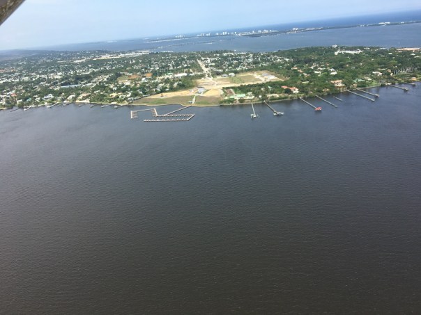
Today I share “on the water” visual reporting by my brother, Todd Thurlow. On Saturday, March 18, 2023, Todd and family took a boat ride to the popular Sandbar area just inside the St Lucie Inlet of Martin County. This is a region my husband Ed and I have been documenting since the 500 cubic foot per second discharges from Lake Okeechobee began by the Army Corp of Engineers on January 22, 2023. First there was no algae reported then there was. The ACOE has started and stopped at least three times as reported by TCPalm, but now with the weather cool the gates are again open.
For months, from the air, the historic seagrass beds have looked like a desert.
Todd’s pictures close up, on the water, show some life and give hope that by June or August there may be more lush seagrass meadows as retuned in 2022. Sprigs of seagrass, although light, are visible along with young welch, conch, and moon snails. Wading birds and sea birds can be seen feeding on and around the flats. Rays or manatees take off -hiding in sand cover. Such a beautiful place! This area and its critters are protected; be careful and thoughtful when boating here. It is an Indian River Lagoon aquatic preserve.
Ravaged by discharges from Lake Okeechobee in 2013, 2016, and 2018, the SLR/IRL does not need any Lake O water, this particularly holds true when blue green algae has been reported by the SFWMD, ACOE, FDEP, and the public.
Thank you Todd for this documentation 3-18-23 taken around 11: 50 am.
Thank you for FWC – Florida Wildlife Commission- for creating these IRL Aquatic Preserve signage to help educate and protect seagrasses. Please share! IRL A.P. 18-24 large seagrass_sgn
Todd Thurlow is the author of the website eyeonlakeo.com for “science for the everyday person.”
My husband Ed took these aerials yesterday March 4, 2023 around 11am. He described it as a “mid tide” between high and low. Also swinging by Port Mayaca, at Lake Okeechobee, this time there was no visible algae.
Following Ed’s aerials I am including those of Dr. Scott Kuhns whose photographs taken on February 27, 2023 around 10am showing streaks of algae caused the ACOE to close gate S-308 at Port Mayaca for about 2 1/2 days. Kudos to Dr Kuhns! And thank you to the ACOE for closing!
So the pictures directly below are Ed’s 3-4-23 and those following are Scott’s 2-27-23. We will continue to document the discharges with hopes they will be halted. We all agree that St Lucie River suffers under the discharges. She was taking water to avoid algae in summer. No one thought algae sightings would begin so early in February, but they have. With this discovery, it is time to 🛑 stop! Cyanobacteria is impossible to 100% track and understand. It is too ancient and will outsmart us every time. Close the locks.
IRL/SLR Sewall’s Point to StuartSky River Warriors since 2013. Pilots & friends Dr Ed Lippisch & Dr Scott Kuhns. This photo was taken by JTL in 2016.February 27 by Dr Scott Kuhns. This photo caused the ACOE to close S308 for two and one half days.
As shared in my recent blog post, Hurricane Nicole brought a significant storm surge to the St Lucie River and Indian River Lagoon region. Many residents experienced flooding and property damage, especially of docks and seawalls.
Today, 11-16-22, my husband, Ed, went up in the RV plane and took pictures to compare to others we took prior to Hurricane Nicole.
It has been quite a time. Nicole hit Florida on November 10, 2022 and Hurricane Ian on September 28, 2022. The river has taken two recent hits.
When Ed got home and I asked him how the river looked, there was a pause and he replied, “just like old times…” meaning “not good.”
Ed’s photos were taking during a rising tide around 1:15 November, 16, 2022. You will see that there is the flushing/cleaning of incoming ocean water from the St. Lucie Inlet. If the estuary is left alone, in time, a few weeks, it will significantly clear up. If the ACOE discharges from Lake Okeechobee, (the Lake is at 16.22 feet) it will not clear. Tomorrow’s (11-17-22) Rivers Coalition meeting at 11am at the City of Stuart Chamber, 121 SW Flagler Avenue, Stuart, Fl 34994, will address this issue, also the issue of “sending water south.” The guest speaker will be LTC Todd Polk. I encourage all to attend.
-Sewall’s Point between the SLR/IRL -click on to enlarge.-Ernie Lyons bridge from Sewall’s Point to Hutchinson Island- IRL–Jupiter Narrows far left, SLR-Plume in Atlantic Ocean coming out of St Lucie Inlet
On Friday, April 9, the Army Corp of Engineers announced it would halt discharges to the St Lucie River/Indian River Lagoon on Saturday, April 10. The Corp has been discharging from Lake Okeechobee since March 6th. Today Lake Okeechobee sits at 14.14 feet. Please read above link for details.
These aerials were taken by my husband, Ed Lippisch, yesterday, Saturday, April 10, 2021 at approximately 1:30 pm during an outgoing tide, from 3000 feet over the St Lucie River/Indian River Lagoon, and 1500 feet over Lake Okeechobee and the C-44 Canal.
There have been documented reports of algae near Port Mayaca at Lake Okeechobee as well as on the the west coast -April 8. Ed’s photos from April 10 reveal some algae in C-44 canal near the railroad bridge just inside the S-308 structure, but none was visible in Lake O near S-308 from the altitude of the airplane.
Ed, myself, and the River Warrior crew will continue flights documenting the visual condition of the St Lucie River/Indian River Lagoon. Always watching. Always sharing.
When we are not flying, you can follow along electronically via my brother Todd Thurlow’s website eyeonlakeo.
J&E
-Sandbar and barren (no visible seagrass) Sailfish Flats area of the St Lucie River/Indian River Lagoon. Visually, water is a mixture of blue and brown, mostly transparent, near St Lucie Inlet.-Discharges exiting St Lucie Inlet over nearshore reefs. It will take a few days for the river to clear up. -At Lake Okeechobee, Port Mayaca, S-308 Structure to C-44 Canal leading to St Lucie River-C-44 Canal at railroad bridge just inside S-308 structure. Algae visible on right side. -C-44 at St Lucie Locks and Dam S-80 Structure AKA “The 7 Gates of Hell.”
Information:
Florida Oceanographic Society WQ Report “B” March 31-April 7, 2021
Documenting the Discharges, Saturday, April 3, 2021.
Since last week, the ACOE has lowered discharges to the St Lucie River from 500 cubic feet per second to 300. The lake is now down to 14.44 feet from over 16. Blue-green algae has been spotted in the C-44 canal near S-80 at St Lucie Locks and Dam. This canal connects Lake O to the St Lucie River and blue-green algae is always of concern as reported my Max Chesnes of TCPalm. Ed and I saw no algae at S-308 on Lake Okeechobee from the air. The water does have an odd hue-perhaps due to wind. We did not get over S-80 due to weather conditions.
This go around, the ACOE began discharging on March 6, 2021 to the St Lucie River, so yesterday, when these photos were taken it was 28 days after the discharges. The aerials were taken from about 3000 feet, at approximately 3:30pm, on an outgoing tide. Conditions were windy, cloudy, and all waters were stirred-up.
Please note federal, state, and local links on subject following photographs.
~Wishing all a Happy Easter and Spring time! See you next week. Ed & I will continue to document the discharges.
J&E
Running images of S-308 at Port Mayaca, Lake Okeechobee and over the St Lucie River/Indian River Lagoon near Sewall’s Point the dividing peninsula of these waters-merging at the Crossroads and Sailfish Flats near the St Lucie Inlet. Photos Ed Lippisch.
SFWMD canal and basin map. C-44 canal is the canal most southerly in the image connected to Lake Okeechobee. Note S-308 at Lake O and S-80 at St Lucie Locks and Dam.
Ed and I continue to document the discharges by air – “a picture speaks 1000 words…” ACOE continues discharging from Lake Okeechobee at 500 cubic feet per second as reported last week and week before. Lake Okeechobee is going down, and today, 3-22-21, sits at 14.79 feet.
Aerials taken over St Lucie River/Southern Indian River Lagoon on 3-21-21, 12.30 pm, incoming tide, over St Lucie Inlet and Sailfish Flats between Sewall’s Point and Hutchinson Island, Martin County, Florida. One can see the effects with sediment cloud discharging into Atlantic Ocean and darkening waters. Nonetheless, salinity conditions are safe for oysters and Florida Oceanographic has water quality at a B-. Please read information section above for details.
Yesterday, Friday, March 5, 2021, around 3:30pm, my husband Ed and I, took a flight over St Luice River/Indian River Lagoon. We knew we needed to document because word on the street had been that there was a good chance, with Lake Okeechobee over 15.00 feet, and rainy season approaching, the SFWMD and ACOE would soon be recommending a special HAB DEVIATION-discharging to the estuaries. Since 1948, the two agencies have worked together to manage the Central and South Florida System.
In any case, when Ed and I heard the announcement 4:48pm, less than an hour after arriving home from our flight, -that the ACOE would open S-80 at St Lucie Locks and Dam from Lake Okeechobee- “tomorrow, March 6th,” we were speechless.
“Wow. Thank God we got up in the plane,” I said to Ed.
Today, I offer our St Luice/Indian River aerials as a visual day-before-discharges baseline. Of course I am terribly disappointed. Ed keeps telling me I need to cheer up. I doubt that I will, but I can say that I am grateful that now water will also start going south, and that natural resources are being taken into consideration by the agencies. Unfortunately, there are not so many natural resources left.
~As we have since 2013, Ed and I will continue to document the discharges.
SFWMD image: C&SFFCP’s canals to the St Lucie. The western C-44 and Lake Okeechobee had no historic connection the the St Lucie River. The first five photos were taken in the area of the St Lucie Inlet over Sailfish Flats between Sewall’s and Sailfish Points. The flats presently are devoid of seagrasses. -Looking east over the St Lucie/Indian River estuary from Stuart to the Atlantic Ocean.-Looking south to Jupiter Narrows of the Indian River Lagoon. The St Lucie enters around the peninsula of Sewall’s Point. -St Lucie Inlet and “Crossroads/” Where the St Lucie and Indian River meet and exit the St Lucie Inlet. -Close up of St Lucie Inlet and Crossroads.-Looking north, up the Indian River Lagoon. -Jupiter Narrows looking south over Peck’s Lake. Note a controlled burn in Hobe Sound in the distance. -North fork of the Loxahatchee River lies in Hobe Sound and Jupiter just south of the St Lucie River. -Circling back over the St Lucie Inlet near St Lucie Inlet State Park on Jupiter Island. Here you can clearly see the waters that lie between Sewall’s Point and Sailfish Point at the Crossroads of the SLR/IRL. -Looking west over Sewall’s Point and Witham Field towards Stuart one sees the north and south fork of the St Lucie River and the Indian River Lagoon on the west side of the peninsula. Look hard and you will see the straight line of the C-23 canal-the boarder of Martin and St Lucie Counties.
~St Lucie Inlet with Crossroads of SLR/ILR at Sewall’s Point Ed’s February 3, 2021 photos of the St Lucie River & Indian River Lagoon at the St Lucie Inlet are unusual. Taken during cold temperatures and windy conditions at 2:15pm – at “dead high tide,” they show the incoming blue waters with a milky quality juxtaposed to the darker estuarine. This combination is one I have never seen, ever. Ed and I have been documenting since 2013. When I first saw these photos, I posted a few on Facebook stating: “Interesting…”
Later, my brother Todd wrote back:
“I just saw Ed’s pictures of the river. When we were out last weekend the St. Lucie was that milky blue. With the pounding waves offshore, the water was full of suspended sand. You would think that sand is actually beneficial when it is transported inside the estuaries to settle on top of the muck bottom. I did YouTube videos of the Bahamas after Dorian when the entire Bahama bank and outer reefs were that same milky blue.”
So that’s what’s going on! Interesting!
Today I share more of Ed’s recent photos. They are taken from 4000+ feet which gives a much broader perspective and highlights the beauty of the St Lucie Inlet region in spite our struggle to revive our seagrasses and protect our water from discharges, especially those of Lake Okeechobee. On February 3, when these aerials were taken, the ACOE was not discharging having halted January 9th, 2021 after 3 months. At the present moment the ACOE does not have plans to discharge from Lake Okeechobee. The lake is presently sitting at 15.37 feet.
This could be problematic for the St Lucie come summer…
*Thank you to my husband, Ed Lippisch for taking these photos!
I posted most of these photos on Facebook, but today I will give explanations and document on my blog. From above, our St Lucie/Indian River Lagoon remains beautiful, but we must be sensitive to the losses beneath the waters. These aerials were taken during a “slack tide” between 12 and 2pm on December 9, 2020 by my husband, Ed Lippisch. December 9th was the last of five days the ACOE stopped discharging from Lake Okeechobee; however S-80 was discharging “local runoff.” (Click on chart above.) Unfortunately, due to high lake level and lack of storage reservoirs, since these aerials were taken, the ACOE has begun ramping up Lake discharges once again.
Below Lawrence Glenn of the South Florid Water Management gives a comprehensive ecological report covering low-salinities and loss of oyster spat in the St Lucie and other aspects, positive and negative, for the entire Everglades system.
Below is an explanation of aerials documenting discharges December 9, 2020. All photos by Ed Lippisch.
-S-80 at St Lucie Locks and Dam discharging local basin S-80 runoff on December 9, 2020
S-308 at Port Mayaca, Lake Okeechobee closed on December 9, 2020. No algae visible.
-Plume of along Jupiter Island south of St Lucie Inlet
-Dispersing plume in Atlantic Ocean just past Peck’s Lake in Jupiter Narrows
-St Lucie Inlet -St Lucie Inlet State Park, Sailfish Point, Sewall’s Point, Stuart, Jensen
-Looking north to Sailfish Flats between Sewall’s Point and Hutchinson Island. This area has greatly degraded since 2013 as far as loss of seagrasses and fishing opportunities
-The area below, especially around Sailfish Point, was once considered “the most biodiverse estuary in North America” as documented, first, by Grant Gilmore
-This photo reveals seagrass loss across many areas of the Sailfish Flats
-Another view between Sewall’s and Sailfish Point, a seeming desert…
-Close up, Sailfish Point
-Sewall’s Point, east Indian River Lagoon
-Sewall’s Point is a peninsula surrounded by the St Lucie River on west side, and Indian River Lagoon on east side
Ed Lippisch, selfie. Thank you Ed!
As you can tell, I have lots of people helping me. Whether it is Ed flying or my brother Todd who provides an incredible easy to read website called EyeonLakeO. You can click below to check it out. The more we know, the more we document, the more we can overturn the destruction of our beloved estuary…
1.Ed and the Super Cub 2019. Our “eye in the sky” since 2013.
2.Tip of South Sewall’s Point looking north to Hell’s Gate. Witham Field, Stuart, west.
We continue to document the discharges…
Yesterday, 3-17-19, my husband, Ed, flew the Super-Cub over the St Lucie River/Indian River Lagoon ~ twenty-one days after the ACOE started discharging from Lake Okeechobee on February 24, 2019.
When Ed arrived home, I asked, “So how was it?”
“Brown,” he replied.
“Like dark coffee brown, or kind of like that weird mixed greenish-brown?”
He looked at me, and smiled. “Jacqui, it was brown.”
“OK, I said, I’ll take a look at your photos.”
So here are the photos from Ed’s flight from Witham Field in Stuart, over Sewall’s Point and Hutchinson Island, then out west to S-80 to see the “Seven Gates of Hell” where you can see the one gate discharging now at an average of 250 cubic feet per second, down from an average of 500 cubic feet per second. As you can see from the SFWMD chart below, there has been other runoff locations as well, but the majority is from Lake Okeechobee.
3. Approaching the SL Inlet, algae covered remaining seagrass beds
4.Sandbar formation inside of SL Inlet
5.Blurry but shows boats at the Sandbar and that weird green brown color
6.Sailfish Point and SL Inlet algae covered remaining seagrass beds
7. Ernie Lyons Bridge, IRL with SL inlet and Hutchinson Island in distance
8. S-80 along C-44 Canal or the Seven Gate of Hell, boats going through locks, “250” cubic feet per second coming though
The following phots are of Caulkins Water Farm, a former orange grove that died due to citrus greening that now holds water from the C-44 Canal. This is a wonderful thing! As local ag-man Mr. Hadad, told me once, “Jacqui we spent 100 years taking the water off the land, and we’ll spend the next 100 years putting it back on.” The later photos are of S-80 again with view of C-44 canal leading west to Lake O.(https://www.facebook.com/CaulkinsWaterFarm/)
9.
10.
11.
12.
13.
14.
15.
16.
17.
18.
19.
20.
21.
22.
23.
24.
The following photos are when Ed headed back to Witham Field going once again over the St Lucie Inlet over the Atlantic Ocean. You can see the water looks blue north of Sailfish Point north of the inlet with nearshore reefs visible. Plume is also visible south of St Lucie Inlet. Also in photos is the winding Jupiter Narrows and St Lucie River in the area of Stuart and Rio. You can see Langford Landing with scraped orange soil and docks built into river still under construction since 2015.
S-80 looking towards Lake Okeechobee one sees discharges coming through gates, photo Ed Lippisch 2-24-19
These aerial photos were taken yesterday, 2-24-19, by my husband, Ed Lippisch. The first two are of S-80, the structure at St Lucie Locks and Dam that drains water from the surrounding C-44 basin and also allows water to enter the St Lucie River/Indian River Lagoon from Lake Okeechobee.
On Friday, the ACOE announced it would be working up to 500 cubic feet per second to be discharged from Lake Okeechobee to the St Lucie River for possibly the next three weeks. These photos are meant as a starting point, and Ed and I will continue, weather allowing, to document the discharges. The discharge numbers can be viewed on the ACOE website but they are alway a day behind: http://w3.saj.usace.army.mil/h2o/reports.htm Website: https://www.saj.usace.army.mil
Structures and canals south of LO 2013 SFWMD map showing canals. The ACOE controls the structures discharging to the estuaries on east and west and the SFWMD controls those going south.
Ed and I plan on taking another flight next week to see how these discharges have visually affected the St Lucie and will do so until they are ended.
S-80 of the C-44 Canal is connected to the South Fork of the St Lucie River, here looking towards Stuart and Atlantic Ocean, note discharges coming through gates. Ed Lippisch 2-24-19
Beaches south of St Lucie Inlet by Peck’s Lake, (being-renourished). This area is also known as the Jupiter Narrows. Photo Ed Lippisch 2-14-19.
View of Sailfish Flats over Hutchinson Island, 2-24-19 Ed Lippisch
St Lucie Inlet where SLR and IRL meet at Atlantic Ocean, 2-24-19 Ed Lippisch
SL Inlet showing Jupiter Island south and Hutchinson Island north, 2-14-19 Ed Lippisch
Documenting the discharges, is critical whether by air, on the ground, or from outer space.
The two videos above were taken by me over S-308 at Port Mayaca, the opening from Lake Okeechobee to the St Lucie River, and over S-80 at St Lucie Locks and Dam on Friday, July 20th, 2018. The satellite images below, my brother Todd Thurlow provided, were taken the same day.
It is clear that the blue-green algae/cyanobacteria, covering, at its height, 90% of Lake Okeechobee, has run its course and bloomed. Now, as the “flower falls,” we see what’s left.
As seen in the aerials, and what the satellite images cannot portray, is that the algae is still there just lessened. Flying out over the lake a light green algae film remains over the water, a pastel shadow of its once flourescent self.
7-20-18, light colored algae, Lake O off eastern shoreline, JTL
The seven aerials at the end of this blog post were taken by my husband, Ed, this afternoon, July 22, 2018 around 4pm. The tremendous green shock is gone, but squiggly lines of nutrient bubbles remain, and blue-green algae visibly lines the eastern shoreline to be sucked into the gates…
Will another gigantic bloom arise? Another flower to replace the dropped blooms of yesterday? Only time shall tell…
One thing is certain. Nutrient pollution (Phosphorus and Nitrogen) is destroying Florida’s waters, and unless non-point pollution, especially fertilizer runoff from the agriculture community, is addressed, faster than Florida’s Basin Management Action Plan requires- pushed out 30 or more years, we are will be living with reoccurring blooms indefinitely.
Sentinel-2 L1C, True color on 2018-07-20.jpg 1,668×1,668 pixels, courtesy of Todd Thurlow. Visit Todd’s site here: http://www.thurlowpa.com/LakeOImagery/
Ed Lippisch S-308 at Port Mayaca, the opening form Lake O to C-44 Canal and SLR, 7-22-18
Ed Lippisch 7-22-18
Ed Lippisch 7-22-18
Ed Lippisch 7-22-18
Ed Lippisch 7-22-18
Ed Lippisch 7-22-18
Ed Lippisch 7-22-18
Timely quote for thought by the late Mr Nathaniel Reed 1933-2018
“…The fact that the Department of Environmental Protection and the Everglades Foundation have at last identified every polluter in the vast Okeechobee headwaters is an astonishing feat. The sheer number of polluters is mind-boggling.
The failure to enforce the possibly unenforceable standard (best management practices) shines through the research as testament to the carelessness of our state governmental agencies about enforcing strict water quality standards within the watershed.
There is not a lake, river nor estuary in Florida that is not adversely impacted by agricultural pollution.
As one of the authors of the 1973 Clean Water Act, I attempted late in the process to include agricultural pollution in the bill, but the major congressional supporters of the pending bill felt that by adding controls on agricultural pollution the bill would fail.
Now, 54 years later, fertilizer and dairy wastes are the main contributors to the pollution of the waters of our nation. Algal blooms are all too common even on the Great Lakes.”
When the St Lucie River/Indian River Lagoon start to deteriorate due to discharges, things start going downhill fast. And when my husband Ed and I start taking and sharing aerial photos, my world becomes a bit chaotic.
Sometimes there are days of hundreds of photos to look through, and knowing the importance of getting them out immediately, choices have to be made. Facebook is a better medium than my blog for real-time info as it takes less time, but my blog is better for historic documentation as it is “permanent.”
So today I am sharing more of Ed’s photos from 6-5-18, and some you may have already seen. Mind you, after heavy rains, stormwater has been pouring in from many canals but, always, like clockwork, after the ACOE starts discharging from Lake Okeechobee, the river looks not just cloudy-coffee brown, but contaminated.
The ACOE started discharging from Lake Okeechobee on 6-1-18, and as most of you know, now, there are not only algae blooms spotted in the lake, as Ed accidentally found on 6-2-18, and others also documented, but also in the St Lucie River. More than likely, there will be more and more algae bloom popping up as the Lake O water makes its way down the estuary, over the tip of Sewall’s Point, towards the St Lucie Inlet. Algae floating down the river is disgusting enough, but toxicity is the real question…
Ed and I will take and share more aerials in the future, to document the algae blooms should they explode, but until then, here are some photographs from 6-5-18 that I had not yet archived on my blog. Sadly enough, although there is no algae in these pictures, I cannot say they will make you feel any better.
Never take the pressure off politicians to build the EAA Reservoir and get it to where it needs to be to clean and filter this water to send south as Nature intended. Government knowingly contaminating its citizens is not an option. Health, Safety and Welfare is a responsibility.
Photos taken 6-5-18 showing SLR/ILR near Sewall’s Point; Jupiter Narrows; Atlantic Ocean/beach over nearshore reefs along Jupiter Island just south of St Lucie Inlet; out in ocean near Peck’s Lake; Sailfish Point/Sailfish Flats area; and Bird Island, a Critical Wildlife Area, for many threatened and endangered birds.
SLR on west /IRL on east – looking towards Sewall’s Point
Jupiter Narrows near St Lucie Inlet
A Coffee Ocean along Jupiter Island just south of St Lucie Inlet
Discharges in waves looking east to Peck’s Lake
Discharges going over near shore “protected” reefs
Discharge plume
Plume out about 2 miles in Atlantic/documented at 5 over days by fisher people
Similar photos give felling of flying over
Reefs with plume coming on
Selfish Point and Sailfish Flats area one the “most biologically diverse in North America.” Seagrass is gone due to receptive discharges episodes
Circling home- close up souther tip of Sewall’s Point
Again circling ove Sailfish Flats on way back to Witham Field.
Bird Island just off of southeast Sewall’s Point is home to hundreds/thousands of birds. Many threatened and endangered species raise their young on this island that was designated a CWA or Critical Wildlife Area by FWC in 2014. At the time it was the first to be designated in 20 years.
Last Thursday on November 16, the ACOE reported they will reduce the amount of water they are releasing from Lake Okeechobee. The Corp had been releasing at a high rate, on and off, since September 20th. New targets are 2800 cfs east and 6500 cfs west.
Photos below were taken yesterday, 11-19-17 by my husband, Ed Lippisch. We will continue to document the discharges from Lake O, and area canals.
As Thanksgiving approaches, we are thankful the discharges are lessened and that the SFWMD and the public are working hard to plan the EAA Reservoir Senator Negron fought for… We the people of Martin County, will not be satisfied until these discharge stop. The river has its hands full with unfiltered discharges draining agriculture and developed lands from C-23, C-24, C-25 and C-44. All must be addressed.
“And where the river goes, every living creature that swarms will live, and there will be very many fish. For this water goes there that the waters of the sea may become fresh; so everything will live where the river goes…” Ezekiel
St Lucie Inlet, Sailfish Point R, Jupiter Island L, and Sewall’s Point and mainland Stuart in distance.
Sewall’s Point
Manatee Pocket
Hell’ s Gate Sewall’s Point to right
C-23 main SLR
Confluence of SLR/IRL at Sewall’s Point’s southern tip
Sewall’s Point
IRL looking towards Sewall’s Point and Stuart. Incoming tide pushes plume waters north into IRL
somewhere looking down…
SFWMD canal and basin map. C-44 canal is the canal most southerly in the image and was connected to Lake O in 1923. C-23, C-24 and C-25 were built later in the 50s as part of the Central and South Florida Project that over-drianed South Florida causing many of the water problems we live with today.
Atlantic ocean off Jupiter Island, plume water moving south over nearshore reefs
IRL near Sailfish Flats where seagrass forests used to flourish housing many fish…
These aerial photos over the St Lucie Inlet were taken by my husband, Ed Lippisch, Sunday, October 29, 2017, at 1:45pm.
The number one issue here is the polluted waters of Lake Okeechobee being forced into the SLR/IRL because they are blocked by the Everglades Agricultural Area from going south.
The ACOE has been discharging Lake O waters into the St Lucie since mid-September. These over-nutrified and sediment filled waters continue to destroy our economy and ecology on top of all the channelized agricultural and development waters of C-23, C-24 and C-25. Stormwater from our yards and streets also adds to this filthy cocktail.
Near shore reefs, sea grasses, oysters, fish? A human being? Better not have a cut on your hand…Not even a crab has an easy time living in this.
We move forward pushing the SFWMD and ACOE for the EAA Reservoir with these sad photos and the fact that our waters are putrid at the most beautiful time of year as motivation. We will prevail. One foot in front of the other.
Hurricane Irma may be gone, but her waters are not. Our now black river and the giant plume off the St Lucie Inlet attest to this. Clean rain that fell in our region during the hurricane is now filthy “stormwater” discharging, unfiltered, through manmade canals C-23, C-24, C-25, and C-44. Nature did not design the river to directly take this much water; this much water kills.
Every plume looks different, and this one is multilayered with no clear border. Sediment soup, black-brown in color, yesterday it extended out about 2/3 of a mile into a stirred up Atlantic and flowed south, in the rough waves not quite having made it to Peck’s Lake.
Since Hurricane Irma’s rains, area canals dug with no environmental foresight in the 1920s and 50s for flood control, and to facilitate agriculture and development, have been flowing straight into the river. On top of this, in anticipation of the hurricane, three days prior to IRMA the Army Corp of Engineers began discharging from Lake Okeechobee. During the hurricane they halted, and then started up again at high discharge levels reaching over (4000 cfs +/-) this past Friday, September 15th. As Lake Okeechobee rises and inflow water pours in from the north, and is blocked by the Everglades Agricultural Area in the south, we can expect more Lake O discharge on top of the canal releases themselves.
As advocates for the St Lucie River we continue the fight to expedite the building of the EAA reservoir and to create a culture to “send more water south.” In the meantime, we, and the fish and wildlife, and the once “most bio diverse estuary in North America,” suffer…
My brother Todd, has complied many other links on his website’s favorites under St Lucie River and ACOE/SFWMD: http://www.thurlowpa.com/news.htm
Post Irma flight over St Lucie River/IRL 9-17-17
SFWMD canal and basin map. C-44 canal is the canal most southerly in the image. All canals shown here discharge into the SLR/IRL.
The confluence of the St Lucie River and Indian River Lagoon at Sewall’s Point, an area once full of seagrasses and fisheries and formerly considered the heart of “the most bio diverse estuary in North America.”
Waves in plume breaking over offshore reefs; looking north to Hurchinson Island.
Southern edge of plume along Jupiter Island and Jupiter Narrows south of St Lucie Inlet.
Looking south off St Lucie Inlet.
South edge of plume looking south towards Jupiter Island.
S-80 dumps from Lake O into the SLR, image created by Doc Snook, 2013.Regarding Senate Bill 10, and the recent changes made to the bill~
I thought I would just go on-line and compare the first bill to the second with its amendments…kind of like juxtaposing town ordinances between first and second reading. Well, I learned over the past week, that this is not as easy as I had anticipated. In fact, to interpret well, I think I need a lawyer, or to become one.
Nonetheless, today I have gathered information to help us understand what is/has happened with Senate Bill 10. The essence of its changes is encapsulated in these recent words by Senate President Joe Negron about the bill:
“Harmful discharges from Lake Okeechobee have flooded communities on the St. Lucie and Caloosahatchee Rivers with massive amounts of toxic algae that destroyed estuaries and harmed the local and state economies. Unfortunately, incidences like these are not unique in our state and are a symptom of the lack of attention to water resource development. The lost summer must be a wakeup call for all Floridians.”
Powerful words from a Senate President. And between the lines we see that he is trying to build bridges to garner more support…as the powers that be have been repeatedly clubbing the bill over the head, in form with their outdated ideology.
So the bill has changed, it may be slightly wounded but it is still alive, and the dramatic destruction of our St Lucie/Indian River Lagoon has become the seed of change for our entire state. Wow. This is fitting as Martin County has a history of inspiring change and being a leader when it comes to the environment.
Ernest Lyons, the great “Stuart News” newspaper man, and others are in their graves smiling I am sure. He may even be smoking a cigar.
Nonetheless, we must remain the epicenter of this state-wide change…we must keep foucs.
The toxic destruction from Lake Okeechobee is a not by accident, but a rather a state and federally sponsored decision embedded in a power culture that has ruled for over one-hundred years. It is time to crack this wide open, thus even though the bill is morphing Senate Bill 10 must keep the EAA land purchase and reservoir component.
And although it has grown to include others, it still has this critical component.
Concerns?
The Florida Wildlife Federation states:
“Unfortunately SB10 has been substantially amended to include funding for water supply developments (pipes and pumps)…The bill changes the direction of the state’s major land acquisition programs from conservation purposes, to acquisition and improvements to land and water areas to protect, restore, and DEVELOP, water resources…These amendments are concerning…” I trust FWF’s concerns are warranted and should be looked at.
Now for the fun part! Below you can compare the two bills, it has gone from 14 to 27 pages!
The press releases following help interpret the bill’s intent. Below the Florida Senate links are two reporter’s insights that I feel are quite helpful, Isadora Rangel of TCPalm and Nancy Smith from Sunshine State News.
In closing, we must never give up because we are destined to change the long-standing culture of drainage and destruction for the St Lucie River/ Indian River Lagoon and now for the great state of Florida.
MORE PROJECTS ADDED
Bradley also added projects to garner support from lawmakers across the state. Those include:
• Creating a loan program to help government and private entities pay for water storage projects that prevent it “from being discharged to tide or otherwise lost to protect the waters of the state.” The loan would pay up to 75 percent of the project and give priority to alternative water supply in areas with limited water sources or that are threatened by salt water intrusion.
• $20 million for grants to help local governments convert septic tanks to sewer systems or remove muck in the Indian River Lagoon and the St. Lucie and Caloosahtachee rivers, as Gov. Rick Scott has proposed;
• $35 million per year for the restoration of the St. Johns River and its tributaries or the Keystone Heights Lake Region;
• $2 million annually for septic-to-sewer conversions, stormwater projects, muck removal and other water quality projects in the Florida Keys.
Sunshine State News, Nancy Smith
The Coast-to-Coast Comprehensive Water Resource Program includes the following:
— Acceleration of the timing and funding for the state share of the Everglades Agricultural Area Storage Reservoir Project. The bill authorizes the purchase of land for the project from willing sellers in the EAA and does not authorize the use of eminent domain.
— Funding of the state share of all existing Comprehensive Everglades Restoration Plan (CERP) projects in the integrated delivery schedule (IDS), including the Lake Okeechobee Watershed Project, the C-43 West Basin Storage Reservoir Project, the C-44 Reservoir Project, the Western Everglades Restoration Project, the C-111 South-Dade Project, and the Picayune Strand Restoration Project.
— Direction to the Army Corps of Engineers to begin the reevaluation of the Lake Okeechobee Regulation Schedule to take into account repairs to the dike and new southern storage features to increase storage in the lake as early as possible.
— A new bonding program, building on the Florida Forever model that recognizes the need to bond for water resource protection and development across Florida. The bill transfers the remaining $3.3 billion of existing bonding authority from Florida Forever to the Florida Coast-to Coast Water Resources Initiative. The bill does not create additional bonding capacity.
— A new revolving loan financing program and statutory tools to allow the state, water management districts and local governments, to develop and operate water storage and supply facilities to service regional populations addressing the growing need for water supply in the state.
— Dedicated LATF funding to expand Legacy Florida to include projects addressing water quality and restoration with the St. John’s River and the Florida Keys.
— Funding to aggressively address the retrofitting or conversion to central sewer systems of outdated septic systems consistent with Gov. Rick Scott’s leadership on this issue.
— Provisions that encourage reuse by establishing a water reuse grant program, specifically to assist wastewater treatment facilities to expand capacity to make reclaimed water available for reuse.
A biography of the late Ernest Lyons, Stuart News editor and nationally recognized for his writings in support of the environment and the St Lucie River: http://www.flpress.com/node/63
Hurricane Matthew a CAT 4 was 42.8 miles from shore, Google Image via Todd Thurlow
Hurricane Matthew over Florida, Terra MODIS via Todd Thurlow
Martin County was fortunate to “dodge the bullet” of category 4 Hurricane Matthew, but as long as the St Lucie Indian/River Lagoon is attached to Lake Okeechobee via the C-44 canal, the river cannot. She is shot in the chest each time.
These photos taken yesterday morning by my husband, Ed, show the discharges, like blood, gushing out of the St Lucie Inlet. Melodramatic personification? Perhaps, but true.
A press release by the Army Corp of Engineers on October 7th stated:
“Lake Okeechobee continues to rise; today’s stage is 15.93 feet…
The Corps has resumed discharges from Lake Okeechobee after suspending them during the storm. Water managers have removed target flows and will release as much water as practical through Moore Haven Lock (S-77) located on the west side of the lake, and the Port Mayaca Lock (S-308) located on the east side of the lake…
‘We anticipate inflows to the lake will increase as a result of Hurricane Matthew,’ said Col. Kirk. ‘Therefore, we must maximize outflows in order to slow the rise in the lake and be as prepared as possible for additional hurricane season uncertainty…”
“Additional uncertainty?” Not for the river.
As the Corp has been discharging from the lake since January 29th, 2016 and now the gates are wide open to save life and property south of the lake, the St Lucie did not really dodge a bullet at all. She is hemorrhaging once again.
Until Lake Okeechobee is redirected south as God designed, “dodging a bullet” in Martin County remains an illusion.
2-10-16, 9AM Looking at peninsula of Sewall’s Point, SLR/IRL. Photo by Dave Stone and Ed Lippisch. Incoming tide pushes plume back into IRL and SLR. Witham Airport seen beyond in Stuart/Martin County.
Today’s first photo was taken by Dave Stone a good friend of my husband and a professional pilot. Taken with an iPhone it shows and incoming tide yesterday, 2-10-16, over the once seagrass rich Sailfish Flats.
The video below the photo shows yesterday’s Lake O/canals/run-off plume having traveled out the St Lucie Inlet moving along Jupiter Island south of Bridge Road far past Peck’s Lake. The video is taken using a Go-Pro by Ed Lippisch.
These videos and photographs are helpful tools of understanding and documentation. Recent others are included below.
Thank you to my husband and the pilots of Witham Aero Club.