It is absolutely beautiful outside. There is not a cloud in the sky, humidity is low, the temperature is perfect, and for all the wading birds and fishes “spring has sprung.” They are excitedly searching for food, but there is little to be found. In the past week, salinity has dropped like a rock and a swift current of filth is pushing towards the St. Luice Inlet.
Boating? Are you kidding? I guess you can, but don’t let your kids swim in the water. Dive the nearshore reefs? I don’t think so!
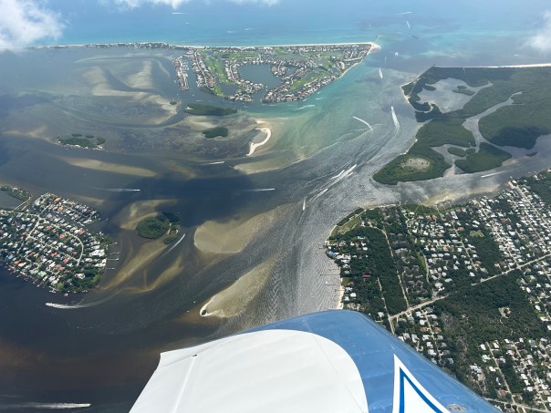
These aerial photographs were taken just eight days after Lake Okeechobee discharges began into the St. Lucie River. The Army Corps of Engineers with the agreement of their local sponsor, the South Florida Water Management District, endorsed the high level discharges though S-80 to begin on 2-17-24.
Today’s photos were taken yesterday, 2-25-24, around 4pm, by Ed Lippisch and Jay Knobel. I am sharing all photographs for purposes of reference and documentation. The fight goes on as it has for 100 years. Shine the light.
Video
~FOLLOW ON Todd Thurlow’s website eyeonlakeo that now shows SALINITY.
~ACOE’s schedule to be repeated unless changed and reassessed each week. I am also including their announcement given to the people on Valentine’s Day.
Little water has been sent south from Lake Okeechobee as the EAA runoff is prioritized and, when rainy, the WCA are filled up like overflowing bowls. The SFWMD aims to “send water south” from Lake O, but it can’t unless there is capacity, and there rarely is…
Yesterday the Army Corps of Engineers announced that they will be allowing a deviation in operations for the Water Conservation Areas. You may recall my recent posts about the high water levels in the manmade, levied water conservation areas and the dangers to wildlife and tree islands and the fact that when they are “full” it is not possible to “send water south” to the Everglades National Park from Lake Okeechobee….
-which means that if the Lake is filling up the St. Lucie River is closer to being discharged to. Today according to the South Florida Water Management District the lake sits at 16.01 feet. If indeed the present strong El Nino unleashes torrents of rain this winter, as it already did on November 15, 2023, or even if not, and the ACOE wants to “plan” by sending non- toxic algae lake water to the estuaries before summer, we are hosed.
Why? Because the system was built that way. It was built to favor some and hurt others, to protect the Everglades Agricultural Area and South Florida from flooding by draining Lake Okeechobee into the St. Luice and Calooshahatchee.
OK. A lot of issues were accepted from the late 1800s through 1948 when the Central and Southern Florida Plan was built. That does not mean it is acceptable today. There are options that would greatly improve the situation, like having everyone including the EAA sugar lands hold water on their lands instead of using the lake like a pond at a homeowner’s association to irrigate their lawn! This is 2024 almost!
It is appreciated that the ACOE is allowing a deviation for the Water Conservation Areas and of course the animals and tree islands must be helped too. But we must realize this it is not enough to save the the St. Lucie River that is almost dead as it is. No false hope.
Yesterday, I listened to the South Florida Water Management District’s Governing Board meeting via Zoom. The overriding issue, besides the fact the St. Lucie River system’s C-44 Reservoir is not working, Lake O is over 16 feet and discharges could soon be imminent, was “high water in the Water Conservation Areas.”
What are WCAs anyway?
They were built as part of the giant drainage system of Florida that “over did it.”
The Water Conservation Areas were built to hold water because we had over-drained, but now sometimes they get too full…
In 1947 there was “the great flood,” that destroyed lands and properties in the seventeen counties of the Everglades Drainage District. This led to the U.S. Army Corps building the monstrosity named the Central and Southern Florida Project for Flood Control and Other Purposes (C&SFP.) The S.F.W.M.D. is the local sponsor. The two agencies work together.
United States Geological Survey explains:
“Historically, water flowed slowly southward through the Everglades in a wide swath. Record floods in 1947 and 1948 led to the construction of a massive flood control project. It served to prevent flooding and store water during dry periods. It also allowed for further development of the growing urban area on the Atlantic coastal ridge.
The project established three Water Conservation Areas (WCAs), one of which is the Loxahatchee National Wildlife Refuge. These areas are delineated in the Landsat images, clearly divided by the levees and canals. Also visible are the Big Cypress National Preserve, Everglades National Park, and Everglades Agricultural Area.Another part of the project is the 100-mile-long eastern perimeter levee, a 3- to 6-meter high earthen berm built to prevent flooding of farmland and urban areas. It runs along the eastern edge of the WCAs, marking a clear separation between the WCAs and urban areas such as Miami, Fort Lauderdale, and Coral Springs.
Along with facilitating the further growth of the urban areas of greater Miami, the other upshot of the project was that the natural flow of water was interrupted, changing the hydrology of the region. The gradual sheet flow of freshwater is diminished, and instead sudden pulses of water are delivered by the canals. These sudden releases caused decreases in the numbers of fish species.”
The bottom line is that when there has been significant rain, like now, the WCAs overfill and the fur bearing animals are seriously at risk, unnaturally surrounded by rising water with no access to their habitat. Deer and other mammals have to take refuge on sacred Native American tree islands or on levees. Often, many species are desperately standing together. Friend and foe. All stressed, all scared, and all hungry.
In 1982 there was a so called “mercy-killing” of over 700 deer that were “starving” in the flooded Water Conservation Area 3. There are concerns that this year a similar situation could arise. I recommend watching the SFMWD meeting under section 28 and all public comments and more if you have the time. This is a very serious issue and no way to treat God’s creatures. How we treat humans during Lake O discharge events is bad enough. It is time to undo the past.
Toxic Lake Okeechobee, June 11, 2023 , Ed Lippisch
Today I share Finding II. of “Conclusions of the Special Project to Prevent the Eutrophication of Lake Okeechobee Relevant to Management Determination for the Everglades Agricultural Area,” Draft Copy, 1975.
Again, I state how important it is that this historic documentation is not stored in our state archives like something out of “Raiders of the Lost Ark,” but rather ready and available to the public. Otherwise, history is rewritten by those with most the power and influence.
For instance, today, one will ofter hear in regards to pollution in Lake Okeechobee, –from those working for and in the EAA,– “The Everglades Agriculture Area (EAA) doesn’t backpump anymore. Our water is cleaner when it leaves than when it came in.” (basically, we are not responsible for the condition of Lake Okeechobee, others are….)
What is missing in this response is that in spite of its numbers the Everglades Agricultural Area remains responsible for damages that plague Lake Okeechobee TODAY.
If you smoked unfiltered cigarettes from the 1940s through the 1980s and then, because of a law suit, the University of Florida and the South Florida Water Management District helped you create “Best Management Practices” that did a great job cleansing your smoke through giant air filters, (like Storm Water Treatment Areas filter the EAA’s dirty water of nitrogen and phosphorus,) would it be correct to say the damage in your lungs has disappeared?
No. The damage in Lake Okeechobee from backpumping is still there and continues to be built upon. The filthy backpumped water of the past is a major reason for the pathetic condition of Lake Okeechobee today. It is time for the EAA and its masters to take responsibility for this and to stop hiding behind their modern day state sponsored improvements.
~begin text:
“With regard to eutrophication of Lake Okeechobee drainage water from 30 percent of the EAA land area is back pumped into Lake Okeechobee during the wet season. An average of 330,000 acre-feet of water entered the lake annually at Structures S-2 and S-3 from the Miami, Hillsboro and New River Canals . In addition drainage districts and the private interest pump approximately 150,000 acre feet of water into the lake from various locations. The EAA irrigation demands draw an average of 438,000 acre-feet from the lake annually…”
Conclusions of the Special Project to Prevent the Eutrophication of Lake Okeechobee Relevant to Management Determination for the Everglades Agricultural Area, Draft Copy, 1975.
Finding II.
Water Backpumped from the Everglades Agricultural Area contributes significantly to the cultural eutrophication of Lake Okeechobee.
The following research evidence is proffered in support of Finding II.
(page 23.) Joyner (1974) found that water pumped from agricultural areas to the southeast is generally the poorest in quality of all water entering Lake Okeechobee….
(page 24.) Brezonik further states: It is clear from the data that Lake Okeechobee presently receives an abundant supply of nutrients. Both nitrogen and phosphorus loading rates or near or above all the (dangerous) levels reported in the scientific literature. (Table 2.) If all backpumping were ceased, the nutrient loading rates would decrease by about 20 percent. This would still leave area loading for nitrogen above the dangerous values, but the volumetric rate would be slightly under the dangerous volumetric rate of Brezonik and Shannon (1971). The photophores loading without backpuming would be lower than all but Vollenweider’s (1968) dangerous rate….
Today I share aerial photographs taken by Ed Lippisch on September 17 around 9:30 am to 10am. The great thing about a photograph is that it speaks for itself! We have avoided a recent tropical storm or a hurricane’s impact on Lake Okeechobee, but the lake remains high at 15.41 feet as reported today by the SFWMD. Stormwater and canals C-23, C-24 continue pollute and discolor the estuary. Remember no fertilizer use during rainy season or if you’re like me EVER! Stay vigilant as hurricane season runs from June 1st through November 30th. Your eyes in the sky, J&E
Today I share an excerpt form “Conclusions of the Special Project to Prevent the Eutrophication of Lake Okeechobee Relevant to the Management Determination for the Everglades Agricultural Area,” Draft Report, State of Florida 1975. It is important that historical information like this is available to the public. It is mind-boggling that in 2023, seventy years since 1953, the issue of eutrophication of Lake Okeechobee has only worsened. Every year the estuaries are plagued by the threat of discharged toxic algae. Reports like this one lie buried in Florida’s state archives in Tallahassee. Most legislators have probably never read it. What has been done to improve water quality is not enough.
Finding I.
Lake Okeechobee is presently enriched and moderately eutrophic. If the present trend of increasing nutrient loads from the drainage basins is not reversed, the lake could become hyper-eutrophic within the foreseeable future.
The following research evidence is proffered in support of Finding I.
In 1953, Dr. H. T. Odum sampled the phosphorus content of Lake Okeechobee and tributaries to the lake. Although not enough samples were taken to have statistical significance, the values of the samples were well below levels consider to be eutrophic.
In 1953, the lake’s watershed was essentially undeveloped. The fact that the lake had low phosphate values in the water column indicates that the lake was not eutrophic in 1953.Water quality samples taken since 1953 have all shown phosphorus values higher than those taken by Odum. This indicates that present levels of phosphorus in the lake result from man’s drainage and land-use practices in the drainage basins.
Today I am including notes from: Draft, A Summary of Progress of the Special Project to Prevent the Eutrophication of Lake Okeechobee, 1975, inspired by my last post. This draft report eventually led to de-chanalizing a substantial portion of the Kissimmee River, the halting of backpumping by the Everglades Agricultural Area, the beginning of Best Management Practices for Agriculture, and conservation for drinking water.
It must be noted that it was the Central and Southern Florida Plan of 1948, after the great flood of 1947, implemented by the Army Corps of Engineers that channelized the Kissimmee River and created the Everglades Agricultural Area (EAA). It took me years to understand this. The EAA and its flood protections were created by our federal government. Then acting in lockstep our state government morphed the Everglades Drainage District into the Central and Southern Flood Control District to manage the Central and Southern Florida Flood Control District-which included the Everglades Agricultural Area. In 1975, around the time of the Draft publication, the Central and Southern Florida Flood Control District was been renamed the South Florida Water Management District. The intensions of the Draft were good, but conflicts of interests continue today with management of the EAA, on both the state and federal level.
Think about it.
So once it was decided the Everglades Agricultural Area could no longer back pump into Lake Okeechobee due to the lake’s eutrophication, the EAA’s government sponsored pollution led to the law suit that now requites all Everglades Agricultural Area “runoff” to go through the Storm Water Treatment Areas to be filtered before it gets to the Conservation Areas thus Everglades National Park. “Lake Okeechobee water” on the other hand sits cooking toxic algae in the still sick lake, before it is sent polluted, unfiltered to the St. Lucie and Caloosahatchee estuaries and residents of those estuaries have no legal standing.
Hmmm?
The Everglades Agricultural Area south of Lake Okeechobee was created and is protected as part of the ACOE and SFWMD’s C&SFP, c. 1948-61.
Begin quotes from text, 1975:
Water back pumped from the Everglades Agricultural Area contributes significantly to the cultural eutrophication of Lake Okeechobee. (pg. 23)
The major causative factors of the present cultural eutrophication of Lake Okeechobee are:
Canalization of the tributary rivers of streams (especially the Kissimmee River).
Backpumping of highly enriched waters from the Agricultural Area, south of th lake , into the lake during the wet season.
Upland drainage practices in the lake’s watershed.
Inadequate nutrient conservation, livestock management, and other agricultural practices in the watershed.
Management and regulation of the lake and its tributaries which diminish their ability to absorb nutrients. (pg. 5)
In view of the fact that the cessation of back pumping would result in a reduction of the lakes present water budget by some 12-14 percent and that water conserving is one of the over-riding management objectives for the South Florida region the committee recommend further that “runoff water from the Everglades Agricultural Area be stored in or near the EAA for subsequent re-use as irrigation water.” This will alleviate the present need to use an average of 350,000 acre feet of water for the lake for irrigation in the EAA and balance the loss of the present 330,000 acre feet contributed to the lake by back pumping. (pg. 10)
Legal and Administrative Aspects of Management have been created and charged with managing various aspect of the region. The present management structure evolved in piecemeal response to growing management problems. Agency responsibilities often overlapped and conflicted and there is no balanced, integrated, or well directed management program for the region. (pg. 11)
Since 1948, the major resource management agency in South Florida has been the Central and Southern Florida Flood Control District which was created to manage the Central and Southern Florida Flood Control Project constructed by the U.S. Army Corps of Engineers. (which includes the EAA.)
I recently received some very interesting comments about a post I wrote in 2022 featuring state archived documents. The title? “Summary of Progress, Final Report on the Special Project to Prevent Eutrophication of Lake Okeechobee.” I decided to share the post again in a different way.
Sometimes looking back makes you wonder if you are going forward…
The hand written corrections and typewritten format on the document really bring it home:
Paragraph two: “The lake has been and is being degraded. Poor land and water management practices in the drainage basin threaten to further degrade and destroy the lake’s indispensable values. This was recognized as early as 1971…”
These aerials were taken by my husband, Ed Lippisch, on August 27, 2023 around 12:15pm. Other than an operational burp from Lake Okeechobee through C-44, it’s canals C-23 and C-24 which drain Port St. Lucie, Allapattah Flats, as well as our Tidal Basin – that are causing the present discoloration and decline in water quality. On a good note, though impaired, seagrass beds are visible near the Sandbar and algae is no longer seen from 1000 feet at Port Mayaca.
As we enter the primary hurricane season it’s unfortunate the alternative canal through the Everglades Agricultural Area once considered by the ACOE in the 1950s to alleviate the discharges is not in place. If history does indeed repeat itself, we must be prepared for more rain and Lake Okeechobee destruction added to the St. Lucie River/Indian River Lagoon.
Most recent ACOE/SFWMD SLR update, 8-22-23Lake O history, ACOE/SFWMD
Rain and runoff plume exiting St. Lucie Inlet Visibile seagrasses and macroalge Sailfish Flats Sewall’s Point between the St. Luice and Indian RiverPeck’s LakeSL Inlet w/ plume
Sailfish Point on Hutchinson Island is next to St. Lucie Inlet S-308 at Port Mayaca C44 Canal aka St. Lucie Canal – no algae visible from 1000 feet
Northern Lake O algae bloom On Saturday, July 29, 2023, my husband Ed returned from flight with 103 aerial photographs of the St. Lucie River to Lake Okeechobee. When there are so many photographs it is difficult for me to decide which ones to include so I have shared most in gallery format.
The St. Lucie River continues to be darkened by C-23, C-24 and storm water runoff while Lake Okeechobee continues to suffer from cyanobacteria blue-green algae blooms primarily in the north. Ed said there was algae in the middle of the lake but that it was more like a “sheen.” Like gasoline on water.
Ed’s photos show algae on both sides of the St. Luice Canal (C-44), but none at S-80, St. Lucie Locks and Dam, and little visible in the lake -again just a greenish color- at S-308 at Port Mayaca lakeside.
The algae in north Lake Okeechobee is dramatic and looks more clumped than I have witnessed previously. Perhaps wind and rain? Strange…
The only good thing I can say is that the ACOE and SFWMD continue to recommend no discharges from Lake Okeechobee to the St. Lucie River. We’ll see about next week.
On July 25, my brother Todd Thurlow eyeonlakeo texted me that S-308 was open at 1656 cubic feet per second but S-80 remained closed. I would imagine this water let in from the Lake Okeechobee was for canal levels or water supply of agriculture. If I were growing crops I would not wish to accept this water as University of Florida Institute of Food and Agriculture Sciences UF IFAS had notes: “Cyanobacterial toxins can accumulate in crop plants, resulting in injury and yield loss; human health may be affected. Impacts of field crop exposure to cyanotoxins in irrigation water are unknown.”
Known or unknown, it can’t be good.
The historic role of agriculture supported by our state and nation is the primary reason the lake is in such awful condition today; this has been documented since 1969. (U.S. Geological Survey in cooperation with Central and South Florida Flood Control District two year study on chemical and biological conditions of Lake Okeechobee, Beyond the 4th Generation, Lamar Johnson 1974.)
Today I share my husband Ed Lippisch’s aerial photographs and one video taken around 11:30am on 7-23-23. Also included in the post are photos of reemerging seagrass beds taken by my brother Todd Thurlow on 7-2-23. A wonderful thing although Todd estimates that just under 80 acres were in the area he visited.
The St. Luice River/Indian River Lagoon is dark from rain, C-23 and C-24 discharge, and stormwater run-off, however most of the ocean looks gorgeous blue. You can even see the nearshore reefs. Seagrass and or macro-algae appear near the sandbars just inside the inlet. Not the 600 acres of yesteryear but some, and this is a good sign. There has been no discharge of Lake Okeechobee since April and that was a small amount with no algae. Nonetheless, it is never good for the river.
Lake Okeechobee shows no major algae blooms near S-308 as just a week ago at Port Mayaca although one can see the long green wisps like shadows in the water. This changes every day and you can follow at eyeonlakeo. This is Todd’s site and it shows Lake Okeechobee at 15 feet. Pray for no hurricanes.
There is algae on the inside gate of S-308 and some along the St. Lucie Canal also known as the C-44 canal as titled when it became part of the Central and South Florida Flood Control Plan of 1948. S-308 is overseen by the Army Corps of Engineers since 1930 but the South Florida Water Management District is involved spaying peroxide pellets on the algae when it gathers in big blue-green-gray rotting clumps as it did last week. The algae dies but more than likely sinks releasing toxins. A conundrum most definitely….
Thank you to my husband Ed who is in his tenth year documenting our waters by air. All of working together are make a difference. We are watching and they know it.
ACOE documented algae at S-308 on 7-13-23.
TODAY’S AERIALS, 7-23-23 by ED LIPPISCH
Sailfish Flats between Sewall’s Point and Hutchinson Island – note seagrass and macro algae in dark waters.
Seagrass with macro-algae near Sandbar 7-2-23, Todd Thurlow.Hermit crab enjoying seagrass 7-2-23, Todd Thurlow.Underwater one can see the macro-algae atop seagrass. Macro-algae is increasing due to nutrient pollution and warmer temperatures. 7-2-23, Todd Thurlow.St. Lucie Inlet with plume juxtaposed to turquoise Atlantic waters.Roosevelt Bridge at St. Luice River, Stuart (L) and Palm City (R).St. Lucie InletAtlantic sideBlue green algae in St. Luice CanalAttachment to FPL cooling pond – algae presentS-308 Port Mayaca at Lake Okeechobee attached to St. Luice CanalClose up vague algae streaks in lake and in enclosed area locks opening to boat thoroughfare.
Gallery various aerials 7-23-23 EL
Canal systems dumping fresh water into SLR, SFWMD visual of Central and South Florida Flood Control canals of Martin and St. Lucie County.
Date taken: 7-12-23 at 1pm/Location S-308 and C-44 Port Mayaca, Lake Okeechobee, FL/Pilot Ed Lippisch.
Three videos are included of the large cyanobacteria-blue green algae bloom off of S-308. S-308 opens into the C-44 (St. Lucie Canal leading into Stuart and out to St. Lucie Inlet.) This bloom waxes and wanes based on conditions but it “always there.” Nutrient pollution must be overcome.
S-308 is presently closed by ACOE. Keep your eyeonlakeo today measured at 14.87 feet.
“Jacqui, you spoke for the water, for the water had no tongue. And with faux righteousness, Florida’s leaders attacked you. God forbid you call out the bad actors…”
“Bad scene this morning, It’s the whole lake covered.” Toxic Lake Okeechobee. Professional pilot Dave Stone 6-24-23 of Ft. Meyers.
“Lake Okeechobee is really lit up around Pahokee.” Ed Lippisch, 6-23-23.
“The cyanobacteria is now on inside of S-308 Port Mayaca, Lake O.” Ed Lippisch 6-23-23.
S-80 St. Luice Locks and Dam C-44 Canal. Discharge of “basin” waters 6-23-23, but no Lake Okeechobee water.
“St Luice Inlet post rains 6-21-23.” Dr. Scott Kuhns
St. Lucie River dark with runoff, C-23, C24, C-44 but no Lake O.
St. Lucie River dark with runoff and C-23, C24, C-44 but no Lake O.
6-11-23 Cyanobacteria in Lake Okeechobee SE/Middle; no algae at S80, C44 as ACOE has gates at S308 Port Mayaca closed.6-4-23 Pahokee SE LO6-2-23 Off Port Mayaca, S. C-38, lake center Thank you my husband Dr Ed Lippisch our eye in the sky. And thank you to my brother Todd who alerts us through his website http://eyeonlakeo.com when to fly. June 1st we entered hurricane season. If a storm causes the lake level to rise significantly there is a real possibility the ACOE will discharge. LOSOM an updated lake schedule that would be more beneficial to the estuaries has been delayed. Be ready. Make yourself heard.
Documenting the Discharges – 2023 to St Lucie River/Indian River Lagoon from Lake Okeechobee – 74 days!
Date: Wednesday, April 5, 2023
Time: Around 11 am
Tide: High at Sewall’s Point
Pilot /Photographer: Ed Lippisch
Location: St Lucie River and Indian River Lagoon, St Lucie Inlet, Nearshore Reefs, Atlantic Ocean, Sailfish Flats, Jupiter Narrows, S-80 St Lucie Lock and Dam in St Lucie Canal (C-44), and S-308 at Port Mayaca at Lake Okeechobee
Helpful Charts – Where are We with L.O. Discharges 2023
The discharges have gone on for a long time. The ACOE with the support of the SFWMD began discharging to the St Lucie River/Indian River Lagoon on January 22, 2023 as the level of Lake Okeechobee had jumped four feet when Hurricane Ian ground through southwest Florida last September.
Then strangely algae appeared in Lake Okeechobee in February, very early in the year, and the ACOE halted and restarted discharges three times as the Colonel was uncomfortable with the visual amount of algae at S-308 in Port Mayaca. Then the weather got cooler and the the algae visually subsided and the ACOE continued the goal of getting the lake down for the next hurricane season for the lake operation schedule. For a hundred years the water that once flowed south from Lake Okeechobee has been increasingly blocked and redirected to the northern estuaries even though once there was a serious ACOE consideration in the 1950s of a third outlet south of the lake, “Plan 6.”
Today I share charts and information that is easy to understand as we enter the fourth named month of discharges. Will they stop? We have been fortunate in that the weather this year has been very dry and the lake is receding. For water managers according to the recent SFWMD Water Resource Form, current projections still have then lake between 13.5 and 14 feet on June 1st. But it seems so dry. Grass is brown and people are watering their lawns like crazy. Wouldn’t it be ironic if we go into a drought and we wish we had the water later? It has happened before. Mother Nature holds the highest cards in this poker game.
Chart tracking total flows to the estuary. Flows to the SLR other than discharges from L.O. are low as little rain, thus for scientists “under damaging range of 1500-2000 cfs.” Courtesy of John Mitnik Chief District Engineer and Asst. Ex. Dir. SFWMD L.O. stages compared SFWMD Weekly Environmental Conditions Report 3-20-23 Salinity levels SLR/DEP 3-31-23 L.O. historical comparison of lake level ACOE/SFWMD. Today L.O. is reported at 14.59 feet. Easy read chart of discharges. Courtesy Todd Thurlow eyeonlakeo.com
Hi everyone. I wanted to share an email written to me by Todd Thurlow yesterday that really made me smile. It shows that we are getting closer to the ACOE halting Lake Okeechobee discharges to the St Lucie River as the lake level is approaching where the Corps wants it to be prior to next hurricane season. And today was so sunny, not a cloud in the sky, surely the lake is even lower. Check eyeonlakeo.com. Have a great weekend!
Jacqui,
With the top of the Eco envelope flat at 14.5ft between 3/15 and 4/1, it looks like we are catching up and could get down in the envelope soon.
(By my calcs – I had to interpolate the top and bottom on my own a while back with no publicly available table to find). The 0.27ft number also appears live on the banner of eyeonlakeo.com. I hadn’t looked at it in a while until I was talking to Lt. Col. Polk today at Rivers Coalition and checked it on my phone. We are only +3.2 inches above to Top, as shown on the banner.
These aerials were taken today, March 22, 2023, around 10:45 am. High tide crested at 11:09 am. Thank you to our eye in the sky and the apple of my eye, Ed Lippisch for consistently photographing the St Lucie River/Indian River Lagoon. Also included is S-308 at Port Mayaca, Lake Okeechobee-checking for algae.
Tomorrow there is a meeting at noon at the St Lucie Locks and Dam of the longstanding defenders of the the river, the Rivers Coalition, asking or one could say, demanding, that the discharges to be stopped. We all know that discharges are helpful for lowing a high (now 14.84) Lake Okeechobee, but not for the health of the St Lucie River/Indian River Lagoon, who has unfairly bore this burden for 99 years.
-St Lucie River/Indian River Lagoon with discharges of 500 cfs. Aerials Ed Lippisch.
Today I share “on the water” visual reporting by my brother, Todd Thurlow. On Saturday, March 18, 2023, Todd and family took a boat ride to the popular Sandbar area just inside the St Lucie Inlet of Martin County. This is a region my husband Ed and I have been documenting since the 500 cubic foot per second discharges from Lake Okeechobee began by the Army Corp of Engineers on January 22, 2023. First there was no algae reported then there was. The ACOE has started and stopped at least three times as reported by TCPalm, but now with the weather cool the gates are again open.
For months, from the air, the historic seagrass beds have looked like a desert.
Todd’s pictures close up, on the water, show some life and give hope that by June or August there may be more lush seagrass meadows as retuned in 2022. Sprigs of seagrass, although light, are visible along with young welch, conch, and moon snails. Wading birds and sea birds can be seen feeding on and around the flats. Rays or manatees take off -hiding in sand cover. Such a beautiful place! This area and its critters are protected; be careful and thoughtful when boating here. It is an Indian River Lagoon aquatic preserve.
Ravaged by discharges from Lake Okeechobee in 2013, 2016, and 2018, the SLR/IRL does not need any Lake O water, this particularly holds true when blue green algae has been reported by the SFWMD, ACOE, FDEP, and the public.
Thank you Todd for this documentation 3-18-23 taken around 11: 50 am.
Thank you for FWC – Florida Wildlife Commission- for creating these IRL Aquatic Preserve signage to help educate and protect seagrasses. Please share! IRL A.P. 18-24 large seagrass_sgn
Todd Thurlow is the author of the website eyeonlakeo.com for “science for the everyday person.”
Due to cyanobacteria sightings and thoughtful decisions of Col. Booth, the ACOE has been “off and on” discharging an average of 500 cubic feet per second to the St Lucie River from Lake Okeechobee (15.06 ft).
Today’s aerials show the St Lucie River and Port Mayaca at Lake Okeechobee on March 11 about two hours after high tide around 1:30 pm. Discharges began January 22, 2023. ~Ed and I continue to document the discharges with the hope that they will be halted as algae is present, visible or invisible, having bloomed early (February) in Lake Okeechobee.
My husband Ed took these aerials yesterday March 4, 2023 around 11am. He described it as a “mid tide” between high and low. Also swinging by Port Mayaca, at Lake Okeechobee, this time there was no visible algae.
Following Ed’s aerials I am including those of Dr. Scott Kuhns whose photographs taken on February 27, 2023 around 10am showing streaks of algae caused the ACOE to close gate S-308 at Port Mayaca for about 2 1/2 days. Kudos to Dr Kuhns! And thank you to the ACOE for closing!
So the pictures directly below are Ed’s 3-4-23 and those following are Scott’s 2-27-23. We will continue to document the discharges with hopes they will be halted. We all agree that St Lucie River suffers under the discharges. She was taking water to avoid algae in summer. No one thought algae sightings would begin so early in February, but they have. With this discovery, it is time to 🛑 stop! Cyanobacteria is impossible to 100% track and understand. It is too ancient and will outsmart us every time. Close the locks.
IRL/SLR Sewall’s Point to StuartSky River Warriors since 2013. Pilots & friends Dr Ed Lippisch & Dr Scott Kuhns. This photo was taken by JTL in 2016.February 27 by Dr Scott Kuhns. This photo caused the ACOE to close S308 for two and one half days.
Today is Ed and my 18th year anniversary. I don’t have a lot of time to go through Ed’s recent photos as we document the discharges so I am just going to post all -of the St Lucie River/Indian River Lagoon from February 8, 2023 taken around 1:23 pm. There are only subtle nuances between them. The ACOE started discharging 500 cfs from Lake Okeechobee on January 22, 2023. You can see the effects in these photographs. The water is able to clear near the St Lucie Inlet at this time. No seagrass in sight. Please see previous post to compare. I will write more soon.
St Lucie Canal, aka, C-44 at S-80, Ed Lippisch 1-22-23. ~Discharges began by ACOE from Lake O at 500 cfs on 1-22-23. For comparison, at worst times 5000 to 9000 cfs flooded the St Lucie on and off in 2013, 2016, 2018. 500cfs (cubic feet per second) is not good, but it is not high-level discharges. JTL
The St Lucie Canal, also known as, the C-44 Canal, is the property of the U.S. Government. Martin County public records show that in the early 1930s, as a result of the 1928 hurricane, the right of way of the Everglades Drainage District was taken as part of the Okeechobee Waterway.
The U.S. Army Corp of Engineers holds jurisdiction and decision making over the canal and the water that flows through it from basins and Lake Okeechobee. Since the great flood of 1947 and the creation of the Central and Southern Florida Plan, there has been a “local partner” in decision making. That partner today is named the South Florida Water Management District, formerly the Everglades Drainage District…
In a modern world, every week, there are conditions calls regarding Lake Okeechobee and the environmental envelope, etc. As in all things, these calls start with the “higher ups” and then end with a public call. The public call is the ACOE Periodic Scientist Call. During this call, stakeholders share conditions and concerns from all over south and central Florida. Most participants are government people or elected officials, but also heads of NGOs and members of the public chime in.
Grey is environmental envelope for Lake O
The process generally works as such: after all these calls, the SFWMD, the local sponsor, puts out an operations statement or recommendation to the ACOE. All of this information is available on line, but its like trying to find a needle in hay stack.
Of course the ACOE and the SFWMD have been communicating all week. At the end of the day, because the U.S. ACOE holds jurisdiction over the C-44 Canal the ACOE is the final decision maker. More than ever, though, they are listening and even seeking public input. This is refreshing!
Pulse to average 500cfs -releases to the SLR from LO, via ACOEO and https://eyeonlakeo.com, Todd Thurlow
The ACOEs has been announcing their decision on the Jacksonville District’s media call on Friday of the week of all the other calls. This past Friday, the day after the SFWMD operations report was submitted, and all the “calls”, January 20, 2023, the ACOE held its media call, and the decision to start discharging from Lake Okeechobee was made make Col. Booth.
Going back a couple of years, Col. Kelly, at the ACOE, came up with an operations plan called a HAB DEVIATION or Harmful Algae Bloom Deviation. This was done after Governor Ron DeSantis put forth Executive Order 19-12 that did all possible to avoid harmful and toxic discharges to the northern estuaries, St Lucie and Caloosahatcee, as years 2013, 2016 and 2018 had been disasters. HAB DEVIATIONS, like all things Army Corp, is engineering-like and complicated, but goal was to allow a deviation from lake operations (LORS or LOSOM) if there was algae in the lake or it was possible there could be algae in the lake, like after a Category 4 hurricane stirs everything up and brings massive runoff…
I am not sure if what the ACOE is doing now qualifies as a technical HAB Deviation, but it is certainly in the spirit of one. Both SFWMD and ACOE have stated they are expecting a large post Ian cyanobacteria blue-green algae bloom in Lake Okeechobee this summer. High lake water in summer would set off releases so they are hopefully dodging a bullet by lowing the lake now.
Due to Hurricane Ian, a Category 4 storm, that obliterated the lower west coast of Florida, coming in just north of Sanibel Island and Ft Meyers, Lake Okeechobee has risen four feet since September 28, 2022 cresting at around 16.47 feet. Because the Herbert Hoover Dike was almost complete, the ACOE did not discharge right away. If the lake had been at the 15.50 limit as before dike completion, there would have been discharges, input or no input.
Yesterday, January 25, 2023, was the ribbon-cutting for the Herbert Hoover Dike Rehabilitation. It took eighteen years. This does not mean there is unlimited allowance of water in Lake Okeechobee, but it allows for more flexibility as will LOSOM. Sediment has been settling in the lake since September/October.
I for one, appreciate the flexibility of the ACOE. In the old world when I entered in 2008, they just followed the book and opened the gates toxic algae or no toxic algae. Now there is awareness and thought. And water quality remains the responsibility of the state. If the ACOE believe/agree a HAB deviation is necessary after a Category 4 hurricane in order to try to avoid toxic discharges in summer when the lake often cooks into a toxic soup, I am all for it. I do not want to go through those type of years again!
These charts below from my brother Todd’s eyeonlakeo.com website show how water was discharged to the St Lucie in 2016, 2018, 2021, and 2022. Although the ACOE is discharging at 500 cfs average now to the SLR, all will be done to avoid another “Lost Summer!”
2016 Lost Summer 2
2018 Lost Summer 3
2021 nice summer even with LO releases (green)
2022 great summer, no releases LO
Photos of Ed Lippisch taken on Sunday, January 22, 2022, the day the 500 cfs discharges began to the St Lucie. These photos are baseline photos to compare to the future. I takes a day or more for discharge water to reach the St Lucie Inlet. The differences in these photos is due to tide and light.
-Stuart News 50th Anniversary Edition, 1964.Today I will complete part three, the final portion of my transcription of an historic 1964 Stuart News, anniversary edition from my mother’s archives. She actually shared this article with me over a year ago and I was so taken by it that I thought it may be an inspiration for a book. I never got around to it, thus now I am sharing on my blog as part of my 2023 new year’s resolution to write more and learn more about the St Lucie Canal. 2024 is the official 100 year anniversary of the St Lucie Canal according to the Department of Environmental Protection.
~Interesting references in part three of the article are the mentioning of a “release canal,” south to the Everglades, something that never materialized; reference, once again, to cutting edge “scientific water control” and the amazing success of the agriculture industry; 1933 noted as the first extreme discharge year from Lake Okeechobee to the St. Lucie River and damaging effects to fisheries and tourism; and in the final paragraph, a future plan linking a new “C-23 Canal on Martin County’s northern border with a major channel which would extend westward to Lake Okeechobee, with a side link to St Lucie Canal, and another channel from St. Lucie Canal southeastward down toward Pratt & Whitney and the Loxahatchee Marshes;” Gulp!
This is a reference to part of the canal system proposed in the 1948 and many following editions of the Central and Southern Florida Plan that thankfully was never built. This reference also leads me to believe that I was incorrect in part two when I wrote the article was written around 1937 or 1920 in part one. With these references to C-23, the article must have been composed after the great flood of 1947 as it is referring to the Central and Southern Florida Project of 1948. I am learning all the time as I sludge through this stuff. The St. Lucie Canal has had so many face lifts! It is hard to know what cut they are referring to!
~As we learn, we are more informed and able to change the future of this huge “ditch” that has defined, benefited, and destroyed the region of our St Lucie River.
So here is a transcription of Part III.
I have entitled my post “The Boon of the Huge Monster Ditch, St Lucie Canal,” as both terms “huge” and “monster,” are noted in full article. To me, the canal is a monster continuing to haunt and terrify. And just like in the movies, I know that until I meet this monster face to face, it wont go away. I hope you will encounter it with me.
You can click on images to enlarge.
Begin transcript paragraphs 11-25:
The great hurricane of 1928, which drowned about 4000 persons in the Lake Okeechobee area, resulted in the widening and deepening of both the St. Luice Canal and the Caloosahatchee River as well as major outlets from the lake. The widened and deepened canal was officially dedicated at ceremonies headed by Secretary of Commerce, Daniel Roper on March 22, 1937.
In the intervening years, the canal’s “good and bad” points have been the cause of growth in the agricultural lands of the interior and of damages to the fisheries and resorts on the coast in periods of excessive discharge. Today, as ever since 1933, when the first heavy discharge from hurricane rains was experienced, efforts are under way to so shape the discharge so that the canal’s benefit can be enjoyed without attendant harm. The U. S. Engineer Corp’s plans for a higher lake level by diking the entire lake may result in less necessity for discharge and a long-range plan has been advanced for diversion of excess water to Everglades National Park by means of a relief-valve canal.
However in the half century which has ensued since the canal was approved, one indisputable fact not clearly seen in the beginning has emerged stage by stage to justify it.
It is “scientific agriculture by water control.”
Thousands of pleasure craft and hundreds of barges, shrimp boats, and other commercial craft use the waterway today, but it never did develop into the “thriving artery of commerce” that was predicted in which ocean ships would sail up to Stuart and load the products of the Everglades Empire brought to the coast by the St. Luice Canal.
Nor did a plan advocated during World War II jell out to make it a major barge and oil transport canal to escape the submarines which infested the Straits of Florida, Yucatan Channel and the Gulf Stream.
What did “jell out” was an expansion all along the route of the the scientific water control for agriculture that was proven at Port Mayaca by that pioneering agricultural beginning in 1925.
G.C. Troup and Troup Brothers at Indiantown on their former 20,000-acre holdings, demonstrated that the combination of irrigation and good drainage would unlock agricultural riches. Today the Minute Maid and Hood corporations are among the huge citrus firms which have planted some 10,000 acres of new citrus and the largest lemon grove in the world on former Troup lands and lands opened to agriculture through water control by P. L. Hinson and others.
On both sides of the St. Lucie Canal, in the entire twenty-five miles of its length, there are spreading pastures, ranches where blooded cattle graze, and the Indiantown area also has some of the country’s largest diaries.
The Bessemer firm that proved it could be done is “in there pitching” with some of the most outstanding modern developments including Westbury Farms 1, 2, and 3, the new Westbury Farms Valencia Groves on the south side of the canal, and the spreading Green Ridge Groves on the north side. George Oliver who manages the giant spread and Michael Phipps of the major corporation are proud of the agricultural and ranching growth but prouder still of St. Lucie Training Park, unique race horse training facility where, “hopefuls” of some of the nation’s top stables get their “running” starts.
They can be found at dawn watching the work-outs on the oval track. Both are skilled polo players.
“Scientific water control with ample supplies from the St. Lucie Canal, and drainage into the canal, is the key to our county’s solid growth,” commented Oliver.
Currently being pushed by Martin County agricultural interests is a new over-all water control plan for the county which would spread the advantages of irrigation and drainage to areas not continuous to the St Lucie Canal.
The new plan would link in C-23 Canal on Martin County’s north border, where huge citrus planting have recently been made, with a major channel which would extend westward to Lake Okeechobee, with a side link to St Lucie Canal, and another channel from St. Lucie Canal southeastward down toward Pratt & Whitney and the Loxahatchee Marshes. Private landowners would link in with these new canals by irrigation pumps and drainage outlet as they have done along the St. Luice Canal.
Today’s post is the second part of a story. A story from the 196450th Anniversary Edition of the Stuart News. “Signalizing Half a Century of Growth and Progress in Martin County,Florida.” It is a huge special edition newspaper, 110 pages!
The article I am sharing is on page 6-H and is titled ” St. Lucie Canal Approved in 1914, Is Boon to Agriculture Here. Huge Citrus Growth Along Water Route; Mayaca Groves First.” I feel this remarkable article given to my mother for her history archives by family friend and real estate man, Ronnie Nelson, must be shared. As the 100 year “anniversary”of the St. Luice Canal is next year in 2024. At this time, I must state I am finding many different dates as to the completion date of the canal, but at this point I am sticking with an article from the Department of Environmental Protection, 1916-1924. (Ecosummary 2001, C-44 Canal)
Learning about the St. Lucie Canal can be confusing because it was “rebuilt” or “improved” and, believe it or not, “celebrated” a few times. I think this article included in the 50th anniversary edition was written as the canal approached its second rebirth in 1937.
There is so much to learn about how the St. Lucie Canal was perceived in earlier times. And it is only through understanding the past, that we can create a better water future for today and for tomorrow.
1964 Stuart News, 50th Anniversary Issue, Thurlow Archives
1964, Stuart News 6-H and 7-H
Transcription begins:
“The completion of this monster ditch will mean much for the Everglades, for south Florida in general, and for Stuart in particular. The improvement of the St. Lucie Inlet and harbor will thus make Stuart the gateway to the Everglades, and millions of dollars worth of agricultural timber, fish, and livestock products will pass through the canal transferring at Stuart onto ocean-going vessels. The canal is, according to contract, to be completed in four years.
First tangible result of the canal for large-scale agriculture was the pioneering effort of the Port Mayaca development back around 1925, created by Bessemer Properties, Inc., a Phipps company which saw the opportunities for agriculture through scientific water control by tapping on to St. Lucie Canal with pumps to provide irrigation in dry spells. At the same time, a series of canals discharged excess water into the canal during wet spells.
Port Mayaca Valencia orange groves today represents the first big-scale successful planting of citrus in Martin County.
Port Mayaca could well be said to be the test plot on which millions were spent to prove, by trial and error, with the best possible scientific agricultural advice, what could be done by enlisting the aid of the man-made waterway.
Paul M. Hoenshel, now a resident of Stuart, was the first agricultural manager in the Port Mayaca development. He was backed by the vision and guidance of such able Phipp’s representatives in Florida as Paul R. Scott and Roy M Hawkins, as was Thomas Gartland when he took over the management in later years.
Port Mayaca was an outstanding “first” because it squarely faced up to the fact that the problems of drainage and water control must be solved if agriculture was to be successful in Martin County. The Phipps interests took the property of several thousand acres and divided it into forty-acre fields separated by drainage ditches, roads, and windbreaks.
About 100 miles of those ditches were dug in the Port Mayaca development, all linked by giant pumps to the life saving waters of the canal. Since Port Mayaca contained both muck lands and sand lands, it was an ideal test tube not only for for its initial 600 acres of Valencia oranges but also for various truck crops, gladiolus- then a major flower crop before chrysanthemums came along- and for experiments in the right grasses and mineral additives to make pasture lands where livestock could thrive…”
~End of transcription. To be continued. JTL
Google Maps 2023 shows Port Mayaca’s location on/near Lake Okeechobee, in Martin County, FL. Blue Dot is area of confluence of St Lucie River/Indian River Lagoon leading to St Lucie Inlet.
At 8am on Friday, July 29, 2022, a group of realtors, environmentalists, reporters, and professionals met at SFWMD headquarters in West Palm Beach. The day had finally arrived for our field trip to the EAA Reservoir/Storm Water Treatment Area south of Lake Okeechobee. The Army Corp will be building the reservoir scheduled to be complete in 2029, and the SFWMD is under construction with the storm water treatment area or “STA” to be complete in 2023. The project, became part of CEPP, the Central Everglades Planning Project, and was reborn through public outcry due to toxic summers and the grit and leadership of Martin County’s 2017/18 Senate President, Joe Negron (SB10). And thus today, like a phoenix, the EAA Reservoir and STA is rising, and will one day be the first structure built to encompass sending cleansed Lake O water south to the Everglades. Make no mistake, this reservoir is the greatest hope for the health of the Northern Estuaries that for decades have been subjected to damaging discharges from Lake Okeechobee.
Well located between the Miami and New River Canals, and neighboring the A-1 Flow Equalization Basin, the 6500 acre STA’s gigantic water cleaning marsh and the 10,500 acre, 23 feet deep reservoir, will be a game changer. Listen the videos below by SFWMD Executive Director for insights.
What a day! What an experience!It was sobering to make the long drive from headquarters through the Everglades Agricultural Area and historic City of Belle Glade knowing this is where Marjorie Stoneman Douglas’ “River of Grass” once flowed. Today Taco Bells replace sawgrass. Over an hour later arriving at the construction trailer along Highway 27, SFWMD engineers Tim Harper, Alexis San-Miguel, Jennifer Leeds, Leslye Waugh and Drew Bartlett were available to educate us. Next we returned to the vehicles dodging the hot sun, weaving our way through the sugar cane fields that will soon be replaced with one of the most extensive environmental restoration projects not just in the country, but in the world! For myself, having been visited in 2019 and 2021, it was inspiring to see and compare the EAA Reservoir/STA today -now really coming out of the ground and taking form with the inflow/outflow canal (across the top) and C-640 (between STA and reservoir). Of course, there are controversies as there always are; this is the essence and history of Everglades Restoration. I am confident, that these water and cultural concerns will be ameliorated in friendly fashion, just as SFWMD mascot Freddy the Alligator emphasizes. I for one, am thankful for all who got us here, particularly Joe Negron. Through participation, education, and inspiration, we will continue the work to “rebuild and restore” the waters of South Florida.
Group portrait with SFWMD mascot Freddy the Alligator L-R: Max Chesnes, reporter TCPalm; Jennifer Leeds, SFWMD Bureau Chief-Ecosystem Restoration Planning; Anne Schmidt (realtor), Deb Drum, Director PBC En. Res. Dept; Todd Thurlow, (website eyeonlakeo); Eve Samples, Exec. Dir. Friends of the Everglades; HB Warren, (realtor); JTL, SFWMD G.B.; Kathy LaMartina, SFWMD Reg. Rep.; Rob Lord, former President of Martin Health/Clevland Clinic); Crystal Vanderweit, photographer TCPalm; Alexis San-Miguel, Section Leader EAA Res./STA; John Gonzalez, (realtor); Ike Crumpler, (realtor assoc. consultant /Upstairs Communications; Drew Bartlett, Ex. Dir. SFMWD; Gil Smart, Friends of the Everglades; Leslye Waugh, SFWMD Eco. Restoration Admin.; Sean Cooley, SFWMD Communications Dir.; Kym Hurchalla, Friends of the Everglades. -SFWMD official group shot 🙂
Everglades Agricultural Area (EAA) Features
Reservoir aka “A2 Reservoir”: 10,500 acres with 240,000 acre-foot storage at about 23 feet deep
STA aka “A-2 Stormwater Treatment Area”: 6,500 acres
Adds 160,000 to CEPP’s 210,000 for a total of 370,000 average annual acre-feet of new water flowing through to the central Everglades ~ ACOE
Blue line = path from SFWMD Headquarters in West Palm Beach to the EAA R/STA and back-My vehicle: JTL, Alexis, Gil, Max, Crystal, Drew, Todd, John, HB, Kym, Eve.-Construction Manager Principal, Tim Harper, shares maps, information and answers questions.-SFWMD Exec. Dir Drew Bartlett explains videos 1&2 -extremely helpful!
VIDEO #1 DREW BARLETT
#VIDEO 2 DREW BARTLETT
-Exec. Dir. Drew Bartlett and JTL arrive on site: smile and wave to Freddy the Alligator! “Freddy the Alligator has come to say hello!” Freddy helps other animals during drought and he and his friends need more and clean water! -Reviewing the site is overwhelming; the reservoir and STA by vehicle cover over eight miles!-Dyno-mite! C-640 Canal divides the STA and the Reservoir. We were treated to a blast during lunchtime. Guest, Eric Eichenberg, CEO Everglades Foundation, and I prepare. We have been waiting for this a long, long time!
-Realtor Anne’s new hat! -John Gonzalez, JTL, HB Warren, Deb Drub, Rob Lord, Eve Samples -Realtors: John Gonzalez, Anne Schmidt, Ike Crumpler, and HB Warren-all worked in Stuart when the horrific harmful discharges from Lake Okeechobee destroyed the estuary and home sales in 2013, 2016 and 2018. “We want clean water!” -My brother, Todd Thurlow, author of eyeonlakeo website, stands before the C-640 Canal that divides the STA and the Reservoir is also part of Friends of the Everglades. This photo was for my mother. 🙂-Thank you SFWMD STAFF! -with David Anderson, RYAN inspector, whom I had met on my previous trip. Thanks David! -TCPalm’s photographer, Crystal Vanderweit, JTL, and environmental reporter, Max Chesnes.-Drew Bartlett, E.D. SFWMD and Bradley Watson, Everglades Foundation.Great that Bradley and Eric Eichenberg joined us too! -JTL and Eve Samples, Friends of the Everglades contemplating the future…-Site photographs, Strorm Water Treatment Area.-My favorite photo of the day, Kym Hurchalla, granddaughter of Martin County’s late environmental leader, Maggy Hurchalla, looks over at what will become the STA. If anything, everglades restoration is generational…-“Black Gold” from the site. Muck, scraped and stored, now used to grow vegetation to protect the levees.-Everything feels big out here! Everything is big out here! -Sugarcane fields transforming into the EAA Reservoir/STA…
Thank you to SFWMD‘s Flicker and my brother, Todd Thurlow, for photos included in this post – all are public!
Toxic algae under the Evans Crary Bridge, St Lucie River, Sewall’s Point 2016. There have not been long-standing, major destructive discharges to the St Lucie or Caloosahtchee since 2018. We certainly do not want them to return.
What is Senate Bill 2508? So it puts a constraint on how you optimize and operate Lake Okeechobee. It elevates water supply above all other system-wide objectives for lake operations. Three years of collective stakeholder work on LOSOM would be overridden forcing water supply guarantees in the EAA that consists primarily of sugarcane. Oh yeah, and if the SFWMD doesn’t conform, no money for CERP projects.
Today I offer Senate Bill 2580 Environmental Resources, which is part of Senate Bill 2500 Appropriations in “black and white.”
First, I share the easy to understand “Background and Effects” of the Bill that was given to me by South Florida Water Management staff at the beginning of the Governing Board Meeting, Thursday, February 10, 2022.
Fourth, highlights of Senate Bill 2508 Environmental Resources include lines 246-273 and 336-351
Fifth, highlights of Senate Bill 2500 Appropriations include section 1647.
Sixth, I offer the response of Governor Ron DeSantis that was also provided to me at the beginning of the South Florida Water Management District Governing Board meeting held Thursday, February 10, 2022. It is time to fight for our estuaries once again. Watch the SFWMD meeting here statrting at 1:23.
C-44 Reservoir, Martin County, FL, 1-19-22, aerial by Ed Lippisch. (Plane: Piper Lance belonging to Dr. Shaun Engebretsen.)Last Wednesday, on January 19, 2022, I received a text from my husband, Ed. The text was brief: “C-44 with water.”
I looked at the message and the photographs and being swamped with reading, I ignored both.
On Saturday, January 22, my brother, Todd, texted me: “They have been bringing lake water into the C-44 basin most of the week via S-308 at Port Mayaca. Now it’s closed and S-80 is open at 811 cfs? This is called “local basin runoff,” to the St Lucie, hopefully just a little blip.”This time, I put down my reading. I called my contacts at the SFWMD and the ACOE to find out what was going on. The ACOE was filling up the C-44 Reservoir via a “high”Lake Okeechobee through S-308 and the C-44 Canal. After a few days, a rainstorm hit, so the ACOE opened the S-80 gates at St Lucie Locks and Dam to get the C-44 Canal level down. Hmmm?
The photos taken from the Piper Lance show the C-44 Reservoir as it was filled on January 19th, 2022. It must be much higher now, six days later.
The filling -for the first time- of the C-44 Reservoir is historic. The C-44 Reservoir is the first major CERP project that was completed by the ACOE and their partners – right here in Martin County.
Part of Indian River Lagoon South, this massive project, and in the future, the EAA Reservoir, give real hope for a better water future: more water flowing south to the Everglades and fewer damaging discharges from Lake Okeechobee to the St Lucie River/Indian River Lagoon.
Check out these photographs!
~FULL, 1-19-22.
Below, I have included three photos from November 26, 2021 that Ed took when he still had the Beechcraft Baron. These photos were taken when the C-44 Reservoir was just a” little bit full” in November after the ACOE’s Ribbon Cutting Ceremony on November 19, 2021.
~NOT SO FULL, 11-26-21.
THE PHOTOS BELOW ARE SHARED TO COMPARE THE “FULLER” PHOTOS ABOVE FROM JANUARY 19, 2022, TO THE “NOT SO FULL” PHOTOS OF NOVEMBER 26, 2021. Ed Lippisch.
NOAA describes Lidar – Light Detection and Ranging- as a remote sensing method used to examine the surface of the Earth. My brother, http://eyeonlakeo.com, Todd Thurlow, shared such an image, of South Florida, during the October meeting of the Rivers Coalition http://riverscoalition.org. Looking at the image, Todd noted that the elevations displayed have not changed in over 5000 years. One can clearly “see” where the water used to go and not go. The tiny St Lucie River on Florida’s east coast was isolated from Lake Okeechobee by a ridge only to be connected to the lake in 1923 by the C-44 Canal -that can also be seen in this image. This why on the east coast we stand strong in saying #nolakeo. We never were and prefer to be unconnected.
-St Lucie Inlet to Atlantic looking beautiful at this time day. Note nearshore reefs.
-Crossroads’ confluence of St Lucie River and Indian River Lagoon, S. Sewall’s Point – note lack of lush seagrass meadows
Jupiter Inlet and Loxahatchee River– heavy rains causing discoloration
Beechcraft Baron, Ed Lippisch, August 21, 2021, 3:30pm
-Looking towards Stuart over Sewall’s Point, SLR/IRL. Sailfish Point Marina left corner.-Sailfish Flats- note shades of seagrasses but no lush meadows-brown coloration -Over Atlantic-Indian River Lagoon lies east of Sewall’s Point, St Lucie River lies west -Various views
-One can see river’s proximity to Witham Field in Stuart. These photos show darkness of St Lucie due to stormwater runoff off lands and canals C-23. C-24, and C-44. No Lake O discharges.
-St Lucie Inlet
-Stuart Sandbar with many boaters. Water is dark with stormwater and canal runoff but remains to recreational standards.
-West now over S-308, Port Mayaca, Lake O – no visible algae from altitude of 1500 feet. Satellite images do show algae on west and middle of lake. SEE my brother Todd’s website EYEONELAKEO for all info. -Although water looks good at St Luice Inlet at an incoming tide, the estuary is suffering from too much input. Read Florida Oceanographic’s update for details.
Today, August 22, 2021 Lake Okeechobee is at 14.39 feet. This recent TCPalm article by Ed Killer gives insights based on a recent media conference with Col. Kelly of the ACOE.
Aerial SLR/IRL near St Lucie Inlet, courtesy Dr Scott Kuhns, 8-11-21.One of the difficult things about trying to keep an eye on the St Lucie River’s health is that destructive forces are coming from so many directions. It’s basically a “three front war.” During and after heavy rains, water is water pouring in, unfiltered, from the northwest, C-23, C-24, and C-25, and also from the southwest through C-44. When things are really bad, and the lake is high, the ACOE can discharge Lake Okeechobee as well. Some may consider this a two front war as Lake O and C-44 basin water are discharged through the same canal (C-44) but as they are separate “animals,” I consider it three.
So in recent weeks, as the rainy season has arrived, C-23, 24, and C-25 have been discharging stormwater runoff form the northwest, and now that C-44 is lower than Lake O (14. 38 feet), the ACOE’s operation is discharging C-44 too. Not yet, has the ACOE started discharging from Lake Okeechobee.
If you have been out on the river you have probably noticed the color is darker and it is going to get even darker as C-44 basin runoff also enters the river.
There are CERP projects set to improve these situations, the C-44 Reservoir and the C-23/24/25 Reservoirs. The C-44 Reservoir will be on line by the end of this year so long as when the ACOE starts filling it up this October, all goes well. The C-23/24/25 are in design and if the economy holds out and our advocacy continues should be done by 2030 or a couple of years before. This is great news! Also the EAA Reservoir, that will accept waters form Lake Okeechobee sending south, should break ground this year and is slated to be complete by 2028. The SFWMD is already well into building the storm water treatment component as the local partner in all of these projects. Thus relief is on the horizon, but until these all up and running, it’s the same old —-.
SFWMD basin map for SLR, note canals and Lake O connections.
Below is a slide from the most recent SFWMD Governing Board Meeting on August 12. Mr Glenn’s slide shows how much runoff was entering the St Lucie. The number is 2432 cubic feet per second daily flow. Over 1400 or 2000 is “off the cuff” considered “destructive.” And now C-44 basin is coming in on top of this. This began through S-80 this Saturday, thus the C-44 runoff is unaccounted for in this slide.
We can look at my brother, Todd Thurlow’s, website and see in real time (almost) how much C-44 water is entering the St Lucie. Yesterday, when I texted Todd at 11pm it was 1049.18 acre feet on 8/14 and 1043.31 acre feet on 8/15. Sorry to be going from cfs to acre feet, but the bottom line is -this is a ton of water that never entered the St Lucie before the canals were dug. These canals are what is what is killing our river as they carry agricultural fertilizers and pesticides together with all the pollution coming from our yards: septic tank effluent, fertilizer, pesticides-FDOT road runoff too!
These aerial were taken from the SuperCub by Dr Scott Kuhns last Wednesday, August 11, 2021, and this is before Saturday when S-80 began discharging to the St Lucie for the C-44 “basin.” Bottom line, the St Lucie is now in a two front war against the northern and western canals, let’s fight for it not to become three. #NoLakeO to the St Lucie. Compare what the river looked on July 28, 201 and as the rains began.
Aerials August 11, 2021, Dr Scott Kuhns
Crossroads SLR/IRL-South Sewall’s Point-Looking south towards Jupiter Narrows-St Lucie Inlet with plume but still able to see nearshore reefs north of inlet-St Lucie Inlet with plume but plenty of blue water-note this is prior to C-44 basin runoff-St Lucie Inlet
LAKE OKEECHOBEE same day. Algae visible in lake off Port Mayaca and S-308 structure-View of S-308 no algae visible from this altitude-Close up of water near S-308. See GPS below.
RAIN RAIN RAIN
Friday night, August 13, 2021, my rain-gage in South Sewall’s Point overflowed! More the 7 inches of rain fell in about three hours causing flash flooding in Martin County, FL. These rains are now exiting our canals.
Viewing Algae on Recent Flights Across Lake Okeechobee
Beechcraft, Baron
My husband, Ed, flew twice recently over Lake Okeechobee on his way to Lee County from Martin County. Once on August 8, and again on August 10, 2021. I asked Ed to snap a few photos to document what the lake looked like from the air. In the images below you can see Ed’s flight path and pictures taken. As Ed says, “the lake is lighting up,” his expression for algae growth. To see daily, easy to find and easy to read satellite Lake O algae images, please view my brother’s website eyeonlakeo. We continue to document Lake Okeechobee and to fight its destructive discharges. On call since 2013, there is no giving up!
ACOE Power Point Lake Okeechobee System Operating Manual (LOSOM)
This pdf file is being shared for those who may not have attended yesterday’s web meeting. Please see link in blue below for power point slides as presented by Col. Andrew Kelly on August 9, 2021. This is process is for a new Lake Okeechobee operating schedule moving beyond “CC.” I know it is confusing. But reading the slides will help!
Ed, Scott, and I, part of your River Warrior team since 2013, continue to visually document the St Lucie River/Indian River Lagoon by air. Although due to algae at the gates of Port Mayaca the ACOE’s lake schedule has not subjected the St Lucie River to Lake Okeechobee discharges since April 10, 2021, the rains and stormwater runoff from surrounding lands and canals C-23, C-24 are flowing. I know I am not an official keeper of rain, however, the rain gauge in my garden has displayed significant rain over Sewall’s Point in the past weeks. See ACOE & SFWMD recent official documents below.
Today I will share aerials from Dr Scott Kuhns. A view from the Super-Cub. These aerials reflect a visual change in the water color due to the rain. The water is darker and contains sediment, and all other that runs off roads and lawns, and agriculture fields out west. Sometimes over a million acre-feet of discharge a years can come from C-23 and C-24 alone! We do not need any Lake O discharges on top of this. C-44 runoff (see canal map at end of this blog post) is probably on the way as when the canal level is lower than the lake it is usually made to flow in our direction. Right now the lake is at 13.87 feet. Two tropical systems are being watched. Hopefully, we will not have a hurricane! The river over all has been looking great! Seagrasses slowly returning. Better fishing reports.
It is important we stay on top of things. Continue to advocate! Learn all you need to know about #LakeO on my brother Todd’s website eyeonlakeo.
Dr Scott Kuhns, SLR/IRL, yesterday, August 5, 2021 at 10:00 am. Note Atlantic remains blue in color and St Lucie Inlet as well but there is a plume. The estuary and Crossroads of the St Lucie River/Indian River Lagoon-they are more impacted. The final photo of St Lucie Locks and Dam’s S-80 structure is inland and thank goodness remains closed! Thank you Dr Scott Kunhs for being our eye in the sky and longtime River Warrior documenter!
Documenting the St Lucie River/Indian River Lagoon, 2021
Super-Cub
Dr Scott Kuhns sent me aerials he took from the St Lucie Inlet this morning, July 28, 2021, at 10am from 2500 feet. Although due to rain there is local basin runoff and C-23/24 dumping into the St Lucie River, there is not Lake Okeechobee discharge mostly due to the presence of algae. So we have been fortunate and our waters have been looking great. So blue! Beechcraft Baron
The second batch of photos I already shared on Facebook. My husband Ed took these photos Saturday, July 24, 2021, from about 1500 feet. Seagrass is budding back! One sees the darker colored runoff water inside the St Lucie River/Indian River Lagoon, but again, there is no Lake Okeechobee water thus still blue out over the nearshore reefs and closer to the St Lucie Inlet/Atlantic Ocean. Last, I will share Ed’s aerials inland of Lake Okeechobee taken on July 24, 2021 as well. The lake aerials show algae along the shoreline, but not so much further out. We must heal all our waters including this lake!
Hopefully there will not be a hurricane this season, and the waters of the St Lucie can continue to recover from previous long-lasting Lake Okeechobee discharges. In any case, Scott, Ed, and I will continue to document.
Thank you pilots!
In closing, I must admit that for my whole life, my favorite color has been green, but I love when it’s blue!
SFWMD canal and basin map
Learn all you need to know on my brother Todd’s website eyeonlakeo Click on image to see Lake O and C-44 discharges so far in 2021.
As I continue my now popular retrospective series “Keeping Alive the Power of the Pubic Voice,” the next St Lucie River rally documented in my LOST SUMMER photo archives is dated August 20, 2013 –Ten days after the Beach Rally and and seventeen days after the first Rally at the Locks.
This was the infamous “riverlution” rally at the the St Lucie Locks and Dam when Governor Rick Scott visited. Just days prior to this, TCPalm put out their STOP KILLING OUR LAGOON issue. These were indeed incredible times! Below is an excerpt I saved from WPTV reporter Jeff Skrzpek, and some of my archived photos. Many people you’ll see in the photographs continue today to work for a better St Lucie River and Everglades LOSOM system.
The St Lucie “Lost Summer” led to significant changes to Florida water policy as we shall we in upcoming post. The recent wave started in Martin County and continues to crash ashore today.
Excerpt, August 20, 2013 – WPTV
STUART, Fla. — – “Hundreds lined the road, armed with signs and chanted loudly as Governor Rick Scott zoomed by more than 300 protesters on his way to tour the St. Lucie Lock.
“Save our river!” screamed the crowd as the hot sun beamed down sweaty backs.
After arriving, Governor Scott was rushed into fenced area, topped with barbed wire fencing, walking away from the crowd without acknowledging any of the concerned residents. The chants turned from being loud to all out anger…”
-Jeff Skrzypek, WPTV
A protest sign greets Gov. Rick Scott and state Sen. Joe Negron before they tour part of the St. Lucie River near Stuart,Fla, Tuesday, Aug. 20, 2013, to access the environmental impact of water being released from Lake Okeechobee. Scott is committing $40 million to finishing construction on a storm water treatment project by the St. Lucie River. He says the $40 million investment from Florida will speed up the completion date of the project which he says will protect the water quality in the St. Lucie and Caloosahatchee estuaries (AP Photo/J Pat Carter)
Below” screen shot of TCPalm’s STOP KILLING OUR LAGOON SERIES. Note Eve Samples! I see Larry Reisman and I think that’s Ed Killer in the back. It is hard for me to see and recognize the others with my now “old eyes.” 🙂
I’ve had so many calls and reactions to my recent post “Keeping Alive the Power of the Public Voice,” that I’m going to keep sharing my photo archives of the “Riverlution.” Yes, today’s modern Florida water advocacy all started here in Martin County.
This next set of archived photos is dated August 10, 2013, Lost Summer (only seven days after the Rally at the Locks,) and labeled “Beach Rally for the River.” Photos reveal a large crowd at Stuart Beach and aerials of a black coffee/green algae St Lucie River/Indian River Lagoon. Terrible!
For me, one of the all time most inspirational photos is in this collection. I am displaying it as the first one. It shows a little boy raising his arms in glee towards the sky as Ed’s original River Warrior -the yellow Cub- plane passes overhead and the flag flies! Save Our River! We are working not just for ourselves but for the future. Please keep the power of the public voice alive for all our Everglades’ rivers during the optimization of LOSOM. The voice of the people must direct policy and we must continue to lead the way!
(Email to comment: LakeOComments@usace.army.mil)
Beach Rally for the River, August 10, 2013, Stuart, Florida (Thurlow archives)
As we move into the LOSOM optimization process, let’s recall the power of the public voice that started this St Lucie “riverlution” in 2013. Today in 2021, the River Kidz have all grown up, we have all gotten older, and a slew of new advocates are involved. But as was clear at yesterday’s Rivers Coalition meeting, the movement is still going strong. It got me looking through my photo archives. Amazing! I wanted to share. Let’s all keep alive the power of the public voice for all our rivers – it started here.
TCPALM “Something remarkable happened on the Treasure Coast in 2013. Was it a short-lived phenomenon or the beginning of a sustained movement?”
The beginning of a sustained movement for sure!
~Photos from RALLY AT THE LOCKS, August 3, 2013. Over 5000 people attended having seen surfer Evan Miller’s Facebook post call to action due to the “Lost Summer.”
Today, for documentation purposes, and for those who may not have been able to view, I share the LOSOM presentation slides of the Army Corp of Engineers from yesterday, 7-19-21. This presentation presents their preliminary preferred alternative, CC in twelve slides.