Tag Archives: 2017 discharges lake okeechobee

Documenting the Discharges 12-27-17

I guess one could say the St Lucie River is getting a new year’s present in that yesterday was the last scheduled release from Lake Okeechobee by the Army Corp of Engineers. The entire situation has a similar theme to an abusive relationship where the beaten thanks their oppressor for finally halting…

Therefore, I will not say “thank you.”

http://www.saj.usace.army.mil/Media/News-Releases/Article/1402349/corps-transitions-to-lower-flows-from-lake-okeechobee/

http://www.saj.usace.army.mil/Media/News-Releases/Article/1402349/corps-transitions-to-lower-flows-from-lake-okeechobee/

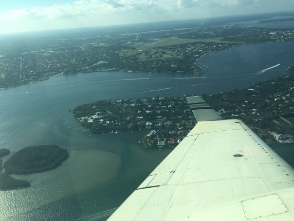
Due to Temporary Flight Restrictions (TFR) because of the President’s visit to Palm Beach, it was not possible to fly south along Jupiter Island from Witham Field in Stuart, however, when the wind and runway changed my husband, Ed, was able to get a few aerials at the Crossroads of the St Lucie River and Indian River Lagoon around Sewall’s Point. No seagrass, but the water already looks better.

After being decimated in 2013; part of 2015; toxic in 2016; and experiencing a no-holds-barred discharge rate since September 20, 2017, post Irma; we will continue to fight for the EAA Reservoir’s success and a better 2018 for our St Lucie River.

We shall never, never, never, give up!

Please see links to my brother Todd Thurlow’s website for St Lucie Canal Real Time Flows S-80 Cumulative 2017 and Latest Lake O Satellite Imagery

http://www.thurlowpa.com/LakeOLiveData/2017/

http://www.thurlowpa.com/LakeOImagery/LakeO3x7days.html

http://tfr.faa.gov/tfr_map_ims/html/index.html http://tfr.faa.gov/tfr_map_ims/html/ns/scale5/tile_14_15.html http://tfr.faa.gov/tfr_map_ims/html/ns/scale6/tile_28_29.html
All photos of SLR/IRL by Ed Lippisch 12-27-17

ACOE data is for previous weeks. Obviously the St Lucie gets enough redirected and area runoff without Lake O. ACOE 12-21-17

A Chocolate Ocean; A Black River, A Disgrace, SLR/IRL

Flight over SLR/IRL to view canal C-23, C-24, C-25 and especially present high releases from Lake Okeechobee through C-44 Canal. JTL/EL 10-14-17

Yesterday, I asked Ed to take me up in the plane, once again to document the discharges. In the wake of much rain and an active hurricane season, the St Lucie River/Indian River Lagoon continues to sacrifice its economy, health, and ecosystem for the EAA and South Florida drainage. A standard operating procedure that is outdated and dangerous.

The discharges from Lake O. have been on and off since Hurricane Irma hit on September 20th. Presently they are “on,” and it shows. Right now our river and ocean shores near the inlet should be at available to boaters, fisher-people, and youth, in”full-turquoise-glory.” Instead, the estuary, beaches, and near offshore is a ghost-town along a chocolate ocean and a black river. The edge of the plume can hardly be distinguished as all is dark, sediment filled waters. A disgrace.

ACOE 10-15-17
10-15-17 Lake O is high. This is a threat to those who live south and around the lake.
South Florida’s southern Everglades, 1850 & today. The water that used to flow south now is sent to the ocean and Gulf of Mexico through canals C-44 (SLR) and C-43.(Cal.) (Map courtesy of SFWMD.)
Image showing drainage of S. Florida through St Lucie and Caloosahatchee rivers. These rivers, that God did not connect to Lake Okeechobee, have been channelized by humans to dump Lake O. This drainage system put in place  in the 1920s does not serve Florida today. Not economically, health wise, or environmentally. We must continue to push to replumb the system the best we can.  (Public image.)

ACOE, Lake O: http://w3.saj.usace.army.mil/h2o/currentLL.shtml
S-308 and S-80 connected to both LO and C-44: http://w3.saj.usace.army.mil/h2o/reports.htm
C-23,(S97) C-24,(S49) C-25 (S99): http://my.sfwmd.gov/portal/pls/portal/realtime.pkg_rr.proc_rr?p_op=FORT_PIERCE

I told Ed it’s best not to smile for this photo. We look forward to seeing the model and timeline from the SFWMD and ACOE for Senator Negron’s reservoir, and the beginning of turning this century old nightmare.


SFWMD basin map for SLR showing canal discharge structures.