Ed’s family came to visit. I was thankful the water was in good enough shape that Ed and I could take everyone out to enjoy the St Lucie River/Indian River Lagoon. The highlight for me was after a boat ride to Peck’s Lake, building a sandcastle with Capri (7) and Cole (5) at St Luice Inlet State Park.
With my hands in the earth at the side of the sea in a place of my childhood, it was as if nothing had changed. Except building the castle out of re-nourished beach sand maybe. But Capri and Cole did not notice.
Ours became a wonderful sandcastle, and together we cheered “We will not retreat” and kept building and adapting as the ocean moved ever-forward. I did not say a word, but thought perhaps I was preparing them for sea-level-rise. In the end, Cole took a shell to the wall and informed Capri and me that a “dinosaur had arrived to destroy the castle!” Capri was not happy; but I assured that it was “OK” as the nesting sea turtles preferred flat sand and would appreciate the tear down.
-Capri (7) Aunt Jacqui (57) and Cole (5)The next day, Ed took the family up for a flight.
It was Capri’s first time and although I was nervous due to temperature and turbulence, she was brave and her parents supportive. All was wonderful, but it did feel a little weird saying: “Capri, don’t be surprised when the giant Lake Okeechobee is bright green.” At seven years old, she gave me the largest of smiles and I smiled back. Then I turned to Ed saying “Babe, you may needed to talk about cyanobacteria (blue-green algae) when up in the plane.”
Ed nodded concentrating on the flight.
Never in a million years would I think to myself that this would be the conversation. In any case, Ben and Capri had a great flight! Kelli and Cole stayed behind with me.
-Ed’s relatives. The Linder family: L to R. Ben, (nephew); Capri; Ed; Cole, & Kelli)-Ben, Capri, and Ed up in the airHere are some aerials of their flight, 7-2-21, 12: 57 pm:
-St Lucie River/Indian River Lagoon at Sewall’s Point, heavy local rain runoff, but no Lake Okeechobee releases.-S-80 St Lucie Locks and Dam, closed.-S-308 at Port Mayaca, Lake Okeechobee open for agriculture water supply but not going through S-80 to St Lucie River.-S-308, note algae inside structure leading to C-44 Canal.-Ed over Lake Okeechobee note age streaks and location of GPS near Clewiston.-Over western and central area of Lake Okeechobee -note GPS.Once we got home, there was no slowing down. Somehow the kids found Ed’s telescope up in the loft. Laughing, but embarrassed, Ed and I realized we had not taken it out in seventeen years!
We were able to look at a nearby oak tree, but not at the stars when they came out at night. The telescope had seen better days.
Even though we didn’t see the stars, it was adorable watching Ed with his niece and nephew. And I though to myself, “things have changed, but things really are the same and we must show the way to the next generation.”
-Ed works the telescope with Cole (5) and Capri (7) after the kids discovered it. -Capri looks towards the future…
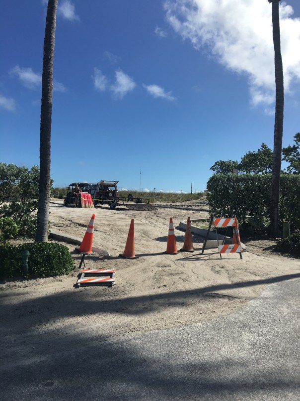
Martin County is furiously fighting erosion at Bathtub Beach. Friend, Amy Galante, sent me a web-cam photo today revealing that ocean water appears to have earlier *breached the remaining man-made dune. When I stopped the by the beach, about an hour ago, at lunchtime, workers assured me no water had entered the parking lot and insisted the area was closed and that I needed to leave immediately. When I got out of my car on the side of the road, it certainly looked as though Mother Nature had left her footprint, but what do I know, I’ve only been visiting Bathtub Beach since I was an infant…
11-15-17: *The County has contacted me asked if I am going to “correct” my post. “The breach you are referring to may be the hole cut in the dune to give equipment access to the beach.” —-I do apologize if my word choice was incorrect. I continue to feel this area of Martin County is one of concern.
Chart 2004-2014. Much re -nourishment has been done since this time. Source: Martin County Government.
Flooding on South Sewall’s Point and Riverview Rd. where I live. On 7-17-15 after a major storm event, super moon and high tides the water was very high. This water has never completely receded. Over the past years the high waters and high tides seem to be occurring more frequently. Not just every 50 or 100 year flood. (Photo JTL)South Sewall’s Point JTL 2014.Aerial public image.
River water from the IRL and groundwater coming up through the grates…
The “tides of change” are coming to Martin County. In some places they are already here. As a member of the Florida League of Cites, over the past years I have met officials from counties south of ours in Palm Beach, Broward, Miami-Dade and Monroe who have formal and open departments within their governments to plan for and deal with sea level rise or “nuisance flooding.” It doesn’t matter what you call it, or what caused it, when it’s happening in your city. You just want it gone…
We in Martin County, we talk about rising tides, but not really. It is something for those people “down there….”
I think we need to bring the conversation up here.
I live in Sewall’s Point, a peninsula in Martin County, surrounded by the St Lucie River/Indian River Lagoon. I have lived here since 1974. After graduating from college I left but did return years later to the beautiful peninsula to marry and buy a house with my husband in 2005. Ed, my husband, lived on South Sewall’s Point Road prior to our marriage, my parents still live here, as does my sister, so I have witnessed and heard about many water/weather events over the years in our fair town.
….….…
I have noticed that since Superstorm Sandy in 2012, even though she did not hit here, the waters in my area of Sewall’s Point seem to be consistently higher. Yes super moons, full moons, high tides, rains certainly have a lot to do with these events, but do they have everything to do with it? Certain hurricanes are documented to cause changes to flooding etc indefinitely—as out in the ocean things have shifted. We may not see the shift, but things have changed and it affects us on land…(http://www.livescience.com/24380-hurricane-sandy-status-data.html)
I don’t know, I am just speculating as I see a changes. It’s hard not to wonder when you see see water on the street almost every day…For the past four years our street has flooded consistently for long periods of time. Even with an outfall fixed there are issues. This time our road has been under various levels of water on and off for a couple of months, before the rain event as well. I have been documenting this in photos and emails for our town and for my neighbors.
The first photo in this blog is flood water from a rain event. The rest is river water. Yes river water that has come up through the grates and up through the ground into our neighborhood.
At first I was driving through the water when it was low…then my husband made me hose off the bottom of my car. Not fun. Since then I have gone one block over to Pineapple….So every day I drive one block over to exit my street.
The past couple of days it seems the water is receding, but if you look closely, you can still see it “high” right under the grate. Vegetation in the area will be and is already dying from the salt water. What will happen to the road?
Yes we that live here know where the flood zones are and cannot feign ignorance, nonetheless, this cannot be ignored..My advice? We must start a conversation with the Department of Environmental Protection and all local governments. We must face reality because she is knocking, right at our front door!
This is an excellent article from the Florida Keys shared with me on the subject:
Flooding advice: Learn to cope
BY Charlotte Twine Free Press Staff
KEY LARGO — Residents of Twin Lakes, withstanding 14 days of floods as of press time, have a nickname for their bayside neighborhood, according to Narelle Prew, who has lived on Adams Drive for 20 years.
“We call it Little Venice. On the street, it becomes a canal,” she said.
Twin Lakes isn’t the only Key Largo neighborhood that is currently flooded during the recent spate of higher-than-normal tides.
Emilie Stewart lives on North Blackwell Lane in Stillwright Point. “The water came 7 feet into my driveway. And Sexton Way and Stillwright Way are both totally under, and Center Lane,” she said.
On the 13th day of flooding, Emilie Stewart posted on Facebook a photo of her street completely underwater with the words, “The flood waters are rising!!!! Cannot believe this!”
Some residents are making their frustration public. Frank Garces, who lives in the Twin Lakes neighborhood and bought his house in May, has created a Facebook page called Key Largo Community Swamp.
In the “About” section, it says, “This page is to promote awareness about the long-time, ongoing flooding problem on Shaw Drive, Crane St. and Adams Drive.” Garces has posted many photos showing the conditions he and his neighbors have been living in.
“At the worst, it was over 15 inches,” Garces told the Free Press. “The water is finally starting to recede. I still have to drive through 5 inches of water. It floods when it rains, but that doesn’t concern me — it goes away in two days. This saltwater issue is more of a problem. It turns our street into a canal.”
In Twin Lakes and Stillwright Point, garbage and mail service has been continuous. But residents worry particularly about the damage that the saltwater is doing to their cars.
“People in my neighborhood are driving through the water, and I’m saying, ‘Oh my God,’” Stewart said. “I’m choosing to keep my cars parked. I walk to Winn-Dixie with a backpack for necessities.”
But for people who have to drive to work, the matter is more complicated than simply footing it to the local store. Garces and his wife, Stephanie Russo, have no choice but to drive through the saltwater in front of their home.
“I’ve got a big Ram diesel truck that can do it,” Garces said. “My wife has a two-door coupe that can’t do it. We rented her a truck from Enterprise to use to drive through the water.”
But driving your car through saltwater, which makes most mechanics cringe at the thought, isn’t the only problem from the flooding.
“The mosquitoes are out of control,” said Garces. “The wake from UPS trucks knocks over garbage cans, and garbage floats down the street. I don’t pay taxes to drive my car through canals and put up with stink and mosquitoes and garbage. That’s not right.”
Prew agrees.
“Our whole neighborhood is actually sinking, we were built on a marsh,” she said. “It shouldn’t have been allowed to be built the way it was. The county approved the neighborhood to be built, and the county should maintain it.”
The Free Press asked Monroe County Commissioner Sylvia Murphy to respond to Prew’s comments.
“This is true, it’s an old neighborhood. Yes, we did,” said Murphy, referring to the fact that the county approved the neighborhood. “At least one of the roads in there is a private road, the rest are county.”
Murphy, however, said solutions to the problem are limited.
“We’re surrounded by saltwater. Saltwater is what’s coming up in the street. There is nowhere for the saltwater to go, which is why it’s on the streets,” she said. “The county is not going to pump out the saltwater because there is nowhere to pump it to.”
Taking the high road
But residents question whether the county could raise the roads to prevent the flooding.
“The concern here is that the roads are low,” Garces said.
“Raising the roads would costs millions and millions of dollars,” Murphy said. “And to raise the road blocks water. Where would the water go? The water has to go somewhere, and that’s for the engineers to figure out. Just because you block it doesn’t mean it’s going to sit in the bay. It’s going to come on the land somewhere. And then those people are jeopardized.”
Judith Clarke, engineering director for Monroe County, said permitting and environmental changes present challenges.
“Unfortunately, potential physical modifications that may be made are not simple,” she told the Free Press. “Street grates allow water to drain by gravity, but with sea level rise, the water elevation is above the road and water comes up through some structures rather than draining into them.
“Construction on roads that are directly adjacent to the open water is subject to permitting through South Florida Water Management District and, depending on the proposed course of action, potentially the U.S. Army Corps of Engineers.”
For now, the county appears to be in studying mode.
“The county has embarked on the climate change adaptation study to develop a strategy to address climate change impacts in the county, a part of which is developing a strategy and criteria to adapt county roadways,” Clarke said.
Not a simple process
Rhonda Haag, sustainability director for Monroe County, said the county has been conducting modeling of several areas of the county for the past 18 months to determine what can be expected for saltwater inundation into neighborhoods, to identify potential road segments at risk of sea level rise, and to review the various infrastructure of the county and utilities. This effort is wrapping up in the next two months.
“It does not address how to address the flooding issues, only what are the flooding issues,” she said. “When this information is presented to our commissioners, there will be recommendations for how to proceed for the next steps. It is not a simple process.”
So why is the water lingering so long in these neighborhoods — 14 days as of press time?
“This was an event where the moon, autumnal equinox and weather all converged at one time to create an extremely high tide,” Haag said. “It’s not often the autumnal equinox falls at the same time as a full moon, but this year it did. The moon was also at its perigee, or the closest point to the Earth for the year. Experts were anticipating a somewhat higher tide due to these conditions. However, the storms and hurricane last week also contributed to the issue by driving strong westerly winds into Key Largo, thereby stacking up the water. Instead of the tidal waters receding with the tide, the westerly winds kept pushing the water in. Therefore, when the next high tide arrived, it stacked on the existing water that hadn’t fully receded.”
But some residents of the impacted neighborhoods say flooding there has been getting worse, rare confluence of circumstances or not.
“This time is probably the worst we’ve ever seen it. I don’t recall having this problem 20 years ago. I notice it more now. The last 10 years have been bad,” Prew said.
Haag didn’t dispute that perception.
“The general level of the sea is rising, so this will contribute to more tidal flooding, called ‘nuisance flooding,’ in the future,” said Haag, who added that Key Largo residents have been calling her to complain about flooding.
Clarke said county staff has received calls about flooding from residents in all parts of the county.
On the radar
Island of Key Largo Federation of Homeowners Association President Dottie Moses, who lives in the bayside Sunset Waterways neighborhood, said the concerns about flooding are on her group’s radar. She said the federation is also in a fact-finding phase.
“In the county there is an effort to raise the 35-foot height limit of homes in order to raise the base flood elevation of homes. We are still exploring the situation,” she said. “Traditionally, the federation is against raising the height limit. With the sea level rise, it has become a bigger discussion.
“I haven’t had the chance to ask homeowners how things are going since this incident. I know how things are going on Facebook and in my immediate neighborhood. We’ll be having a general membership meeting [Wednesday, Oct. 14], and I’ll ask how things are going.”
Garces just wants a solution.
“In no way, shape or form, I’m not slamming anyone in particular,” he said. “Rhonda met with us — she drove her car through saltwater to meet with my wife at our house. Judith called my wife. I just want them to come up with a solution for us.”
And, as he noted on day 14, “Water is getting deeper again today.”
For now, Haag recommended that residents help the county’s research.
“Please take photos of the high tidal waters, and email them to me, identifying the date taken and street,” she said. Her email is Haag-Rhonda@MonroeCounty-FL.Gov<mailto:Haag-Rhonda@MonroeCounty-FL.Gov>. “The county is assembling a database of photos of tidal flooding areas that will help us to identify problem areas and therefore plan for the future on how to respond to these areas.”
And as for what flood-area residents should do with their cars, Haag said, “This would be up to each resident.”
Meanwhile, if Murphy were one of those residents, she said, “What I would do is I would park my car on high ground, I would put on a pair of boat shoes, and I would walk home through the water. I sure would not drive my car through the saltwater. I would take off my high heel shoes, put on my boat shoes and get down to it.
The seawall at Sailfish Point’s Dunes Condominium is right next to the ocean. St Lucie Inlet lies beyond this point by about a quarter-mile. 7-26-15. (Photo Ed Lippisch)
Yesterday afternoon, Ed and I had hoped to walk our dogs, Bo and Baron, to the St Lucie Inlet, but were cut off by an incoming tide and a Sailfish Point’s seawall. Having grown up in Martin County, it is amazing to see such changes “right before my 50-year-old eyes…”
Of course when I was a kid there was no Sailfish Point development, no seawall, no apparent sea level rise, just the beach sun-flowered sand dunes and Bathtub Beach changing daily to the winds of time with the remnants of James Rand’s “Seminole Shores” development crumbling…
Today Sailfish Point is here. Its 625 homes are some of the most exclusive in the county. Built in the 1980’s it was developed by Mobile Oil Corporation. The area brings tremendous tax revenue to everyone and to every school in Martin County…if it washed into the sea there would be issues for all.
Sailfish Point: (http://www.sailfishpoint.com/martin-county/)
It must be noted that the St Lucie Inlet itself is responsible for some of this erosion…the inlet was opened permanently in 1892 by pioneers led by Captain Henry Sewall of Sewall’s Point. Naturally the inlet would open and close with tides and time. Opening the inlet permanently now defines our county, and we would not give it up; but as all things in life: there are both positives and negatives to every action.
Today the waters of the ocean are encroaching….and time seems to be speeding up.
Building on barrier islands is not particularly long-term in that barrier islands are meant by nature to turn over on themselves like a conveyor belt. On the other hand, I have been to the Breakers Hotel in Palm Beach and their seawall is right up to the historic hotel and has been for years….We stave off the ocean as long as we can. Much of Florida east coast is built on barrier islands…
What does the Bible say? “The wise man built his house upon a rock…”
Anyway….today I wanted to share Ed and my walk as it is symbolic of our times.
Google map showing Hutchinson Island showing St Lucie Inlet. Sailfish Point immediately north of inlet. East is Atlantic Ocean and west is the Indian River Lagoon and Sewall’s Point and St Lucie River.
Other than the surreal seawall and encroaching sea….there were many sea turtle nests, marked by the Fish and Wildlife Commission. Many turtles had laid their eggs right up against the seawall! Many of them! I counted at least 50 just in our short walk. Good for the turtles but it seems many nest are doomed to wash away… For thousands of years these turtles have returned to the beaches of their birth to lay eggs. Now many of them literally come up “against a wall.”
Turtle nest right up the seawall at Sailfish Point. 7-26-15.(Photo JTL)Turtle nest close to SP’s seawall. (JTL)Sea turtle nest. (JTL)
I must mention that the people of Sailfish Point are also “up against a wall,” as they have to worry about their homes falling into the sea….Here one sees a sea wall repair taking place. I don’t think the sea wall is that old in the first place.
Home at Sailfish Point undergoing seawall repair. 7-26-15. (Photo JTL)Ed looks inside sea wall being repaired. (Photo JTL)
The most intense erosion seems to be the north area of Sailfish Point, closest to Bathtub Beach….and it is summer. This should be the time the ocean, sands and tides are most forgiving. Winter waves are much more brutal, unless there is a hurricane of course….
The other interesting anomaly Ed, Bo, and Baron and I experienced was the hundreds of sea hare mollusks that had washed up on shore. Ed Killer of TC Palm just wrote a great piece on these interesting, harmless creatures that scientists believe are washing ashore due to cold water upswells and algae shifts in the ocean–their swimming affected, they slow down and are carried to shore by the waves fated to dry out in the sun.
As Ed and I walked back I picked up as many as I could and threw them back into the ocean knowing that really I was only “buying them some time.” Chances are they will wash right back up on the shore. In the end, nature always wins. In time, we like the sea hares, will find this out , but until then it’s a great walk on the beach, isn’t it?
One of hundreds of sea hare mollusks that had washed ashore near Sailfish Point 7-26-15. (Photo Ed Lippisch)
Ed stands with Bo and Baron in front of the seawall at Sailfish Point looking towards the sea….(Photo JTL)
Playing fetch with Bo and Baron, (Photo JTL)Jacqui and Ed, near Bathtub Beach, Stuart, Florida. 2015. We had fun even though the beach is not what it used to be….
THIS ADDITION CAME IN FROM MY BROTHER TODD: AMAZING!
Jacqui–
Interesting blog post!
In the meantime I thought I would respond to your post with a rough video of Sailfish Point while eating my lunch…..
(https://youtu.be/TW8URTQG2o0)
It is a movie of the following:
1. 1935 NOAA Chart – note the jetty already in place
2. 1940 Aerial
3. 1952 Aerial
4. 1968 Aerial – quick. I should have skipped it.
5. 1970 Aerial – note the old “Empire of the Ants” pier and the strange water slick to the south.
6. 1981 Aerial – showing the construction of Sailfish Point.
Look at these two screenshots of the beach just a few months apart late last year—-Todd Thurlow
Google image seawall is covered 8-12-14.Google image seawall is uncovered 12-2-14.
Looking out to the Atlantic Ocean through and ancient black mangrove that was exposed by erosion off of Bathtub Beach.. (Photo 2009, JTL)
There have been many times over thousands of years that the ocean has broken through Hutchinson Island and flowed into the Indian River Lagoon off of Sewall’s Point. Most recently, in 2004, after hurricanes Jeanne and Francis. Also in the early 1960s, at Peck’s Lake*, on Jupiter Island. But of course we “repair” the areas and “put them back”…for a little while anyway….
Peck’s Lake breakthrough ca. 1960, Jupiter Island. (Ruhnke Collection, Thurlow Archives, from the book “Sewall’s Point,” by Sandra Henderson Thurlow.)
I have been fortunate the past few years in my river photography to see the island by air in my husband’s airplane; it never ceases to amaze me that Hutchinson Island, as all barrier islands, is really just a ribbon of sand….
So, of course Mother Nature comes through….
Sand piled hight at Bathtub Beach. (Photo 12-10-14, JTL)
Bathtub Beach is an area that Nature seems determined to reclaim soon. Yesterday, as many, I drove to see the “State of Emergency” claimed by Martin County at Bathtub Beach.
Looking to the ocean….(Photo 12-10-14, JTL)
There was a young couple that had scaled the piled protective sand and I struck up a conversation with them.
“Hi, I’m Jacqui. This is amazing isn’t it?”
The young man replied: “Yeah we came yesterday, and the waves were 10 to 12 feet!” The water was all the way up to this fake dune. Look, you can see the sand is still wet.”
Former Wentworth house, Bathtub Beach. (Photo 12-10-14, JTL)
“Wow,” I exclaimed. “Yes, I have seen this before. It’s incredible. You just have to wonder if one day the ocean will come through so hard she takes it all. This would be terrible for the people who live here…”
The response from the young man?
“Well, at least the river will be cleaner….”
I was amazed to see how far the river culture has expanded, and perhaps the values of a younger generation…
Rather than get into a political conversation with a nice young couple just here to explore, I said how nice it was to meet them, and ran down the sand pile in my high heels to get to my car before I got a ticket.
Wormrock at Bathtub Beach (Photo 2009, JTL)
At 50 years now, I have known our beaches since I was a kid walking around on the worm reef catching fish with a homemade net, before we knew that was “bad” for it. During my youth, the older generation began to really build on Hutchinson Island, which was not such a good idea either….The same goes for the low areas of the Town of Sewall’s Point, across the Indian River, where I live and sit on the town commission. These areas are very vulnerable. It’s a problem.
So how do we deal with this “realization,” that we have built on Mother Natures’ front line? Do we retreat, as in war, knowing we will never win, or do we harden our areas reinforcing the shoreline and our homes as long as we can? Do we spend millions of dollars putting concrete seawalls and dredged sand on our shorelines that will surely eventually wash away and each time, not to mention it covers and destroys our “protected” off shore reefs and sea grasses?
These are the difficult questions, and if we follow the model of South Florida that has been dealing with these issues of sea level rise, and just the “normality” of living on a shifting sandbar that God wants to roll over on itself like a conveyor belt, every few hundred to a thousand years, we have some big problems ahead of us. We can reinforce our shorelines and raise our houses, but in the end, Nature will win. In our short lifetimes, we may not see the “grand change,” but our children and grandchildren will.
For instance, the photo at the beginning of this blog is an ancient black mangrove with a hole in it looking towards the ocean. These mangroves are exposed during high erosion because Hutchinson Island is rolling over on itself. This is called “transgression.”
To repeat, much of the construction on barrier islands happened before people fully understood that these places are particularly volatile.  The clues have been accumulating for decades: beachfronts are thinning, storms regularly swallow dunes and send sand flowing to the far side of the island… Slowly, geologists and government entities have realized that the very nature of barrier islands truly is to “roll over,” typically toward the mainland, as waves and weather erode one side and build up the other. Barrier island ecology is not fully understood; there are many theories. It is complex, but some things we understand now…
Thus when the erosion is greatest, the remnants of an ancient mangrove swamp on the ocean side of the island can be seen….Kind of bizarre isn’t it?
What do they say? “The only constant is change.”
Yes, times are changing, the climate and the oceans are warming; no matter the reason, this has happened before. Our job, as it always has been, is to adapt. But in the world of money, real estate, and ad-valorum tax values to governments—along the Indian River Lagoon, this may never occur, until the ocean is truly upon us…
Ancient swamp on ocean side…..(Photo 2009, JTL)Northerly view of Bathtub Beach and exposed ancient mangrove swamp….(Photo 2009, JTL)Today even with high erosion the ancient mangrove swamp is under the sand. You can see one sticking up…(Photo 12-10-14, JTL)This photo that I found on water/river activist Nyla Pipes’ Facebook page. The view of ocean action along the Atlantic Coast is very telling….
*Originally, I wrote” 1948: as well as “1960” in this blog post as the years that Peck’s Lake opened. Due to communication with my mother, historian, Sandra H. Thurlow, I have changed my blog to say only “1960s.” She believes there was an error in a photograph used in her book, “Sewall’s Point,” in that the photo she used in her book said 1948 but she now, after seeing old shared photos from John Whiticar, thinks this date is incorrect. Please read below:
Peck’s Lake Inlet
The photograph of a wash over at Peck’s Lake in Sewall Point on page 19 is identified as “1948” because it an 8 x 10 print in the Ruhnke/Conant Collection we purchase had that date written on the back.
Year later I began to suspect this was in error.
The clincher was a group of photos that John Whiticar came across that were obviously from Ruhnke which included the washout I had labeled 1948 with others that were obviously from the 1960s because of a flower farm in the background. There were also photos of the drowned trees and Ruhnke family photos of a visit to Peck’s Lake.
A Nov. 11. 1963 article in the Stuart News about Inlet worked said, “Also in April of this year the Martin County Commission passed a resolution asking the Corps of Engineers to take action to insure the boating public would always have as safe an inlet from the ocean as was available at that time through the storm-opened Peck’s Lake Inlet, closed by the Corps this past summer.
12-30-14 I received the numbers on costs from Martin County for beach re-nourishment over the years; I am adding the list here as a photo so I can share it with comments on this blog:
Beach Renourishment Numbers from Martin County 2014.
Artist depiction of a Florida in the future. Sea level rise, public photos.
I have read and listened to people speak about sea level rise before, but for some reason, this time it was different…
Last week, in Hollywood, Florida, at the sparkling ocean side resort, the Westin Diplomat, I listened to Dr Harold Wanless, Chairman of the Department of Geological Sciences, University of Miami. I experienced half denial and half fascination as he gave his unemotional, scientific presentation at the Florida League of Cities Annual Conference. The first sentence he said was “Sometime in the next 30 years, people in South Florida with 30 year mortgages will not be able to sell their homes.”
He cited Miami as the ninth most vulnerable city in the world to sea level rise and number one in exposed assets. He noted the warming and expansion of the world oceans, and the melting of Greenland and the polar glaciers. He said the oceans will rise 2-5 feet by the end of the century. Miami International Airport will be a marsh. He calmly projected that there will be forced evacuation of most barrier islands.
“Guess what?” he said. “The ocean has arrived.”
“The ocean city, Sewall’s Point. The island city that is…”I fantasized.
Dr Wanless like a mannequin continued.
The porous sand of Florida will not allow what Holland and New Orleans have done. South Florida will be under water and if not underwater the water will be so close underground that it will make maintaining roads and infrastructure almost impossible for cities…
At two feet increase, 72% of Miami’s land mass will remain above water. At six feet, 44%.
At this point I started doing the math. In years that is. I wrote down my age, 50, and all the ages of my family. In 34 years, with his prediction for two feet, I would be 84. Ed my husband, 92. My parents in heaven. My sister 81; my brother 78; my nieces 44; 46; 47 and 47. “I guess Ed and I can’t leave the house to the “kids…” I thought.
The whole time I was watching my real estate values go down, I was wondering about my beloved Indian River Lagoon. Can we still save her? Will the ocean reclaim her? Will she still be an estuary? Is all our work in vain?
There were two more speakers after Dr Wanless. Attorney Thomas Ruppert and Assistant Public Works Director of the City of Ft Lauderdale, Nancy Gassman. Basically Ruppert said you can’t win and Gassman said not to panic. Cites have gone through changes before…we must believe in humankind. We will keep building; we will adapt and survive.
As someone who has given my life to the preservation of the St Lucie River/Indian River Lagoon, I felt like “preserve” was suddenly a word that was outdated.
I starred thinking…worrying…’
“I must rather help the lagoon “adapt” to changes the best I can. If this to be, which I do not know, but probably is… I cannot preserve her, in fact I never could, she has always been changing. Wow, this is uncomfortable. It’s like my world is upside down. How can I plan if this is to be the future? …I must stay the course; I will not abandon ship. I will keep my values…
I think I’ll go to my room and look out the window, at the ocean…when is happy hour?
I think I will begin to prepare for the storm ahead…”
–thank you to Mayor, Cindy Lerner, Village of Pinecrest and Ryan Matthews, FLC for organizing this presentation.
FLC links:
Sea Level Rise and the Impacts of Climate Change
SEFAS “map” showing “Florida” approximately 14,000 years ago when it was much larger in size, was more desert like, had no rivers, and only few springs where animals and people converged. (http://www.sefas.org)
This weekend the Southeast Florida Archaeological Society had a display booth at the Environmental Studies Center. After the River Kidz painted my face in honor of Earth Day, I visited the SEFAS table of old maps, ancient mastodon fossils and Native American artifacts.
I started talking with Will Ghioto, the president of SEFAS; he and his wife Charlotte are Sewall’s Point residents. We talked about the FEMA house raising project of the town in light of 14,000 years of Florida history….
According to what I was told, “Florida” was once much larger as one can see by the map above. During this time the climate was more African or desert like and there we NO RIVERS, only a handful of springs. (One can see these named in red above.) These springs of course were the center of life for the people, giant, and smaller animals that lived during that time.
Only later, when the seas rose once again, did the St Lucie River and Indian River Lagoon form as giant rivers of water flowed south from the eastern North America and up through the earth onto and through the slowly shrinking peninsula.
The climate changed, the Everglades eventually were formed, the giant mammals disappeared, and the native people adapted to hunting smaller animals and a different lifestyle.
I stared with mouth open. I had heard this in some form before but I am always fascinated…
As I slowly walked back to the River Kidz table, I heard Charlotte say, “People are successful through adaptation Jacqui, that is one thing that never changes….”
 The next day, Ed took the family up for a flight.
 -Ben, Capri, and Ed up in the air
 Here are some aerials of their flight, 7-2-21, 12: 57 pm:
 -S-80 St Lucie Locks and Dam, closed.
 -S-308 at Port Mayaca, Lake Okeechobee open for agriculture water supply but not going through S-80 to St Lucie River.
 -S-308, note algae inside structure leading to C-44 Canal.
 -Ed over Lake Okeechobee note age streaks and location of GPS near Clewiston.


 -Over western and central area of Lake Okeechobee -note GPS.


 Once we got home, there was no slowing down. Somehow the kids found Ed’s telescope up in the loft. Laughing, but embarrassed, Ed and I realized we had not taken it out in seventeen years!
 -Capri looks towards the future…