These aerials were taken by my husband, Ed Lippisch, on August 27, 2023 around 12:15pm. Other than an operational burp from Lake Okeechobee through C-44, it’s canals C-23 and C-24 which drain Port St. Lucie, Allapattah Flats, as well as our Tidal Basin – that are causing the present discoloration and decline in water quality. On a good note, though impaired, seagrass beds are visible near the Sandbar and algae is no longer seen from 1000 feet at Port Mayaca.
As we enter the primary hurricane season it’s unfortunate the alternative canal through the Everglades Agricultural Area once considered by the ACOE in the 1950s to alleviate the discharges is not in place. If history does indeed repeat itself, we must be prepared for more rain and Lake Okeechobee destruction added to the St. Lucie River/Indian River Lagoon.
Most recent ACOE/SFWMD SLR update, 8-22-23Lake O history, ACOE/SFWMD
Rain and runoff plume exiting St. Lucie Inlet Visibile seagrasses and macroalge Sailfish Flats Sewall’s Point between the St. Luice and Indian RiverPeck’s LakeSL Inlet w/ plume
Sailfish Point on Hutchinson Island is next to St. Lucie Inlet S-308 at Port Mayaca C44 Canal aka St. Lucie Canal – no algae visible from 1000 feet
Today I share my husband Ed Lippisch’s aerial photographs and one video taken around 11:30am on 7-23-23. Also included in the post are photos of reemerging seagrass beds taken by my brother Todd Thurlow on 7-2-23. A wonderful thing although Todd estimates that just under 80 acres were in the area he visited.
The St. Luice River/Indian River Lagoon is dark from rain, C-23 and C-24 discharge, and stormwater run-off, however most of the ocean looks gorgeous blue. You can even see the nearshore reefs. Seagrass and or macro-algae appear near the sandbars just inside the inlet. Not the 600 acres of yesteryear but some, and this is a good sign. There has been no discharge of Lake Okeechobee since April and that was a small amount with no algae. Nonetheless, it is never good for the river.
Lake Okeechobee shows no major algae blooms near S-308 as just a week ago at Port Mayaca although one can see the long green wisps like shadows in the water. This changes every day and you can follow at eyeonlakeo. This is Todd’s site and it shows Lake Okeechobee at 15 feet. Pray for no hurricanes.
There is algae on the inside gate of S-308 and some along the St. Lucie Canal also known as the C-44 canal as titled when it became part of the Central and South Florida Flood Control Plan of 1948. S-308 is overseen by the Army Corps of Engineers since 1930 but the South Florida Water Management District is involved spaying peroxide pellets on the algae when it gathers in big blue-green-gray rotting clumps as it did last week. The algae dies but more than likely sinks releasing toxins. A conundrum most definitely….
Thank you to my husband Ed who is in his tenth year documenting our waters by air. All of working together are make a difference. We are watching and they know it.
ACOE documented algae at S-308 on 7-13-23.
TODAY’S AERIALS, 7-23-23 by ED LIPPISCH
Sailfish Flats between Sewall’s Point and Hutchinson Island – note seagrass and macro algae in dark waters.
Seagrass with macro-algae near Sandbar 7-2-23, Todd Thurlow.Hermit crab enjoying seagrass 7-2-23, Todd Thurlow.Underwater one can see the macro-algae atop seagrass. Macro-algae is increasing due to nutrient pollution and warmer temperatures. 7-2-23, Todd Thurlow.St. Lucie Inlet with plume juxtaposed to turquoise Atlantic waters.Roosevelt Bridge at St. Luice River, Stuart (L) and Palm City (R).St. Lucie InletAtlantic sideBlue green algae in St. Luice CanalAttachment to FPL cooling pond – algae presentS-308 Port Mayaca at Lake Okeechobee attached to St. Luice CanalClose up vague algae streaks in lake and in enclosed area locks opening to boat thoroughfare.
Gallery various aerials 7-23-23 EL
Canal systems dumping fresh water into SLR, SFWMD visual of Central and South Florida Flood Control canals of Martin and St. Lucie County.
-Indian River Lagoon & St Luice River meet to flow into the Atlantic Ocean as seen over the savannas. Nettles Island , a landmark, juts into the IRL (upper left.) Note peninsula of Sewall’s Point and St Lucie Inlet. Aerial photograph by Ed Lippisch, 9/11/22, 6:15pm.Recently, I have been asking Ed to get a “different view” while flying-something other than the location between Sewall’s Point and Hutchinson Island near the St Lucie Inlet. That area is the heart of the matter when documenting seagrass recovery or destructive discharges from Lake Okeechobee. However, the St Lucie River/Indian River Lagoon includes much more than that. The undeveloped savannas region seen above is quite striking.
Here Ed looks south over the savannas, now Savannas Preserve State Park, an area west of the railroad tracks stretching ten miles between Jensen Beach and Fort Pierce.
As my mother, author Sandra Thurlow writes in her book, Historic Jensen and Eden on Florida’s Indian River, …”ours is not a savanna at all. A true savanna is grassland with scattered, small drought resistant trees. Many eons ago the Jensen Savannas was a lagoon like the Indian River. Now the ancient lagoon is a region of lakes, marsh and pine flatwoods. When polar icecaps formed, bringing Florida out of the sea, tides and winds shaped a primary dune along the east coast of the peninsula. The shallow waters in the wetlands behind the dune were brackish. The ocean levels continued to drop and sand bars just off the coast were exposed, forming Hutchinson Island. What had been the primary dune became the Atlantic Coastal Ridge.”
She goes on to explain that prior to modern times the savannas’ ecosystem was almost 200 miles long, but due to development along the Indian River Lagoon the region has been reduced to just ten ecologically intact miles.
Areas such as these “savannas” are critical to the health of the St Lucie River/Indian River Lagoon and an inspiration for more comprehensive protection in the future.
I posted most of these photos on Facebook, but today I will give explanations and document on my blog. From above, our St Lucie/Indian River Lagoon remains beautiful, but we must be sensitive to the losses beneath the waters. These aerials were taken during a “slack tide” between 12 and 2pm on December 9, 2020 by my husband, Ed Lippisch. December 9th was the last of five days the ACOE stopped discharging from Lake Okeechobee; however S-80 was discharging “local runoff.” (Click on chart above.) Unfortunately, due to high lake level and lack of storage reservoirs, since these aerials were taken, the ACOE has begun ramping up Lake discharges once again.
Below Lawrence Glenn of the South Florid Water Management gives a comprehensive ecological report covering low-salinities and loss of oyster spat in the St Lucie and other aspects, positive and negative, for the entire Everglades system.
Below is an explanation of aerials documenting discharges December 9, 2020. All photos by Ed Lippisch.
-S-80 at St Lucie Locks and Dam discharging local basin S-80 runoff on December 9, 2020
S-308 at Port Mayaca, Lake Okeechobee closed on December 9, 2020. No algae visible.
-Plume of along Jupiter Island south of St Lucie Inlet
-Dispersing plume in Atlantic Ocean just past Peck’s Lake in Jupiter Narrows
-St Lucie Inlet -St Lucie Inlet State Park, Sailfish Point, Sewall’s Point, Stuart, Jensen
-Looking north to Sailfish Flats between Sewall’s Point and Hutchinson Island. This area has greatly degraded since 2013 as far as loss of seagrasses and fishing opportunities
-The area below, especially around Sailfish Point, was once considered “the most biodiverse estuary in North America” as documented, first, by Grant Gilmore
-This photo reveals seagrass loss across many areas of the Sailfish Flats
-Another view between Sewall’s and Sailfish Point, a seeming desert…
-Close up, Sailfish Point
-Sewall’s Point, east Indian River Lagoon
-Sewall’s Point is a peninsula surrounded by the St Lucie River on west side, and Indian River Lagoon on east side
Ed Lippisch, selfie. Thank you Ed!
As you can tell, I have lots of people helping me. Whether it is Ed flying or my brother Todd who provides an incredible easy to read website called EyeonLakeO. You can click below to check it out. The more we know, the more we document, the more we can overturn the destruction of our beloved estuary…
This past Saturday, July 25, 2020, my husband, Ed, flew across the state to Ft Meyers to visit pilot and fellow River Warrior, Dave Stone. Along for the ride were two other friends, Scott Kuhns and Don Page.
Before the men flew off, I asked the question, like a tape-recorded message: “Could you please take some photos of the algae in Lake Okeechobee?”
“Sure,” Ed replied. “But we’re just going straight across.”
The afternoon went by, and when Ed returned home, my first question was, “Did you see any algae?”
“No,” he answered. “Didn’t you look at the photos I shared?”
I looked at my phone and clicked on the 52 photos. “No visible algae in Lake Okeechobee? Really hunny?
…Where did you guys fly?”
Ed took a long breath. “I told you Jacqui- straight across.”
“What was your altitude?” I shot out.
“About 2000 feet; why are you asking?” Ed looked at me with wide eyes.
“Were you talking to Scott and Don so much that you didn’t really look?” I inquired.
Ed looked me straight in the eye: “Jacqui, we were ALL looking. I told you, there was none, zero, nada.”
“Hmm.” I mused. “Why then aren’t there any photos of the central or west side of the lake?”
“Because there wasn’t any algae!” His final reply.
So today, I share Ed’s photos.
They highlight Port Mayaca at Lake Okeechobee, C-44 Canal, St Lucie Inlet, Hutchinson Island (with a lot of seaweed), Sailfish Flats (seagrass kind of coming back), and Sewall’s Point (with very little seagrass around Bird Island.) Nonetheless, you’ll see that the water itself looks better all around.
And the algae?
It is wonderful that Ed and his friends saw no visible algae.” Really great.
“Visible” though is the key word here. Cyanobacteria is known for its ability to move up and down in the water column. Sunlight is key. My brother Todd’s website eyeonlakeo reveals daily pass satellites Terra, Aqua -there was heavy cloud cover over Lake Okeechobee parts of Thursday, Friday and Saturday.
In 2016, the year the lake was 90% covered in algae, Dr Edward Philips of the University of Florida Dept. of Fisheries and Aquatic Science was quoted in an Okeechobee publication. I thought it explained all so well, I wrote it down:
“Cyanobacteria have gas vesicles which act as buoyancy control devices. The vesicles can be expanded and filled with gas, causing the cyanobacteria to float on the surface, or deflated, which causes the cyanobacteria to descend into the water column. Just because you don’t see it, doesn’t mean there’s nothing going on.”
No Visible Algae in LakeO? Really Hunny?
Ed and I will back up in the air again soon! 🙂
~Your Eye in the Sky,
Jacqui and Ed
Port Mayaca at Lake Okeechobee
C-44 Canal and S-80. Now closed.
St Luice Inlet and Hutchinson Island
Sailfish Flats between Hutchison Island and Sewall’s Point.
Keeping up the Lake Okeechobee algae bloom documentation, Ed and I flew from Stuart to Lake Okeechobee during a hazy, hot high-noon, on Sunday, July 5, 2020. The algae was much toned down from our previous flights in June. Nonetheless, one could see the pattern, the outline, of the giant bloom from above. Rain may have disrupted its perk but the bloom remains in the water column. The most visual appeared to be in the middle of the lake and again, about a mile or so off Port Mayaca.
I have included photographs of the journey: St Lucie River at Palm City; flying over western lands and under construction C-44 Reservoir/STA ; FPL cooling pond; algae in Lake O; Clewiston; south rim of lake with agriculture and sugar fields; Indiantown and Hwy. 710; DuPuis and Corbett Wildlife Areas; one glance back to Lake Okeechobee; and an updated 2020 “Covid-19 portrait” of Ed and me.
We will continue to document throughout the summer. Keep up the fight! Stop the Discharges! Stop the Algae!
~Your eye in the sky
Jacqui & Ed
St Lucie River at Palm CityWestern lands and C-44 Reservoir/STA under construction-5 STA cells filledFPL cooling pond and edge of LOAlgae in LO off Port MayacaCloser to center of LO
ClewistonSouthern shoreline and agriculture fields, mostly sugarcaneSoutheastern shorelinePort Mayaca, DuPuis, Corbett Wildlife Management Area-dark green
This shot, below, was taken flying back east over the Village of Indiantown. Highway 710 is seen bisecting neighboring Dupuis and Corbett Wildlife Area and John and Mariana Jones Hungryland Wildlife Area. I will be writing more about the protected areas and the highway that cuts through them in the future.
“Hey get rid of that plastic water bottle would ya? 100 degrees or not!” Jacqui & Ed 2020
C-44 Reservoir and Storm Water Treatment Area (STA)
After weeks of algae Lake O shots, when my husband, Ed, went up in the Baron on June 17th, 2020, I looked at him and said: “Could you please also take some photos of the C-44 Reservoir and STA for an update? I need a positive fix.”
Thus today’s photos of the C-44 Reservoir/STA in Martin County, off the C-44 canal near Indiantown, share good news. Most important for me, the pictures reveal that many more of the STA cells are slowly getting filled with water -in December 2019 they started with one as Governor DeSantis pulled the lever. One can see many more cells are now filled. When complete, these cells will cleanse tremendous amounts of nutrient polluted water prior to entry into the St Lucie River. The ACOE projects that construction will be completed by next year. It has been in progress for many years and is a” cooperative” between the ACOE (reservoir) and SFWMD (STA) and a component of CERP.
Program: Comprehensive Everglades Restoration Plan (CERP)
“Located on approximately 12,000 acres on the northern side of the St. Lucie Canal in western Martin County, the C-44 Reservoir and Stormwater Treatment Area (STA) project will capture local basin runoff…” ~SFWMD“Achieve More Now”
There are maps and links at the bottom of this post should you like to learn more. Thank you to all over the years and today helping with the completion of the C-44 Reservoir STA as we work to save the St Lucie River.
Martin County: “Martin County’s land acquisition efforts, this most critical and important project would not be under construction today.” (https://www.martin.fl.us/land-acquisition)
Last night, 4-18-20, after a hiatus, Mother Nature decided to “let it rain” and this morning friends Dr Scott Kuhns and daughter-in-law, Dr Mary Kuhns went for a flight over the St Lucie River and Lake Okeechobee to check things out.Ed and I thank them for sharing their photographs!Update-No visible algae at S-308 or along the C-44 canal. The waters of the St Lucie River are grayish from rain water runoff. Things look good, considering. ~The rainfall numbers across the SFWMD can be viewed at the SFWMD’s 24 Hour Realtime Rain Gauge Site. S-308 at Port Mayaca, Lake OAlong C-44 canal, do you see algae?South Sewall’s Point, rain runoff visibleHole in the wall & St Lucie InletRain plume exciting St Lucie Inlet
Canals in Martin & St Lucie Co.that are connected to the St Luice River: C-23, C-24, C-25 built in the 50s and 60s. C-44 is also connected to Lake Okeechobee constructed in the 1920s. The natural basins of the SLR have been tremendously enlarged damaging the river.
Pin is location east of EAA Reservoir area; Stuart is blue dot, and Chokoloskee is next to Everglades City on lower west coast.
The day began with smoke, smoke off the sugarcane fields.
Yesterday, Ed and I took a flight from Stuart to Everglades City, passing Chokoloskee and photographing the EAA Reservoir lands along the way. It is huge out there in the “Everglades,” seemingly endless. The easiest way to get one’s bearings is to look for the Miami and New River Canals that run south of Lake Okeechobee. Highway 27 parallels the New River Canal; where the red balloon is located above is the area east of where the EAA Reservoir will be constructed. For more specifics see link (https://jacquithurlowlippisch.com/tag/a-1-aerial/)
For Ed and I the flight, although hazy, was an opportunity to learn to recognize from the air Water Conservation Area 3, just south of the EAA Reservoir Area. The water conservation area lands are not located in Everglades National Park, but water quality is protected.
“To me these are the Everglades,” Ed said looking down.
“They are but they aren’t,” I replied. “They are part of the Central and South Florida Project, they are not natural; they are controlled. When they are too full from EAA water, the water from Lake O is not allowed to go south. If too full, from rain, or otherwise the animals can drown. Trapped on the tree islands raccoon, and deer, and panther together. Terrible.”
“Why can’t the water just flow south,” Ed asked.
“Lot of reasons, people like to say it’s because of an endangered bird, but its bigger than that, mostly because we have chosen to make it that way, and powerful entities keep our legislature from changing it in spite of what the voters say.” (SFWMD Constraints: https://apps.sfwmd.gov/SystemConstraintsDataApp/)
Ed did not reply.
We looked forward to what appeared to be little hills. The cypress domes of Big Cypress National Park reflected in the sunlight, and I could see “end of the earth” Chockoloskee right next to Everglades City in the distance. Pretty…
I can understand why people like to live down there so far away from everything. But they too can not escape our problems ~not with water.
Smoke rises over sugarcane fields southwest of Martin County near the Palm Beach Canal
Smoke, canals, sugarcane fields
Belle Glade, FL south of Lake Okeechobee
Ed asked what this is. Not sure flooded fields, mining?
Flowing Highway 27, the A1 on west side begins to show. Now a Flow Equalization Basin this land was once the Tailman Sugar Mill and is located on the east side of where the EAA reservoir is to be constructed.
Looking west of A1 towards A2 where EAA Reservoir is to be built
A1 from another position
The North New River Canal to Ft Lauderdale now follows Highway 27. It once was in isolation as people used the canal to get to and from Lake O from the mouth of the New River
Water Conservation Area 3 (WCA3) lies under A1 and A2 area; although not part of Everglades National Park, it’s water quality is protected:
My husband, Ed, took these photos of the Indian River Lagoon at the St Lucie Inlet on 2-28-18, just a few days ago. They are certainly beautiful enough to sell real estate…The turquoise water is so pretty one could easily overlook the sand desert below the surface waters.
Enjoy the blue water, but know that especially since 2013, our seagrass beds have been decimated by black sediment filled waters and toxic discharges from Lake Okeechobee. Seagrasses are the nursery for all sea life, especially the baby fish. These beds need time to reestablish if they ever will.
True beauty has something to offer, not just “surface water.” Keep your eye on the lake and fight against any coming releases this summer so we can get life back in our dear dead river.
Last Thursday on November 16, the ACOE reported they will reduce the amount of water they are releasing from Lake Okeechobee. The Corp had been releasing at a high rate, on and off, since September 20th. New targets are 2800 cfs east and 6500 cfs west.
Photos below were taken yesterday, 11-19-17 by my husband, Ed Lippisch. We will continue to document the discharges from Lake O, and area canals.
As Thanksgiving approaches, we are thankful the discharges are lessened and that the SFWMD and the public are working hard to plan the EAA Reservoir Senator Negron fought for… We the people of Martin County, will not be satisfied until these discharge stop. The river has its hands full with unfiltered discharges draining agriculture and developed lands from C-23, C-24, C-25 and C-44. All must be addressed.
“And where the river goes, every living creature that swarms will live, and there will be very many fish. For this water goes there that the waters of the sea may become fresh; so everything will live where the river goes…” Ezekiel
St Lucie Inlet, Sailfish Point R, Jupiter Island L, and Sewall’s Point and mainland Stuart in distance.
Sewall’s Point
Manatee Pocket
Hell’ s Gate Sewall’s Point to right
C-23 main SLR
Confluence of SLR/IRL at Sewall’s Point’s southern tip
Sewall’s Point
IRL looking towards Sewall’s Point and Stuart. Incoming tide pushes plume waters north into IRL
somewhere looking down…
SFWMD canal and basin map. C-44 canal is the canal most southerly in the image and was connected to Lake O in 1923. C-23, C-24 and C-25 were built later in the 50s as part of the Central and South Florida Project that over-drianed South Florida causing many of the water problems we live with today.
Atlantic ocean off Jupiter Island, plume water moving south over nearshore reefs
IRL near Sailfish Flats where seagrass forests used to flourish housing many fish…
These aerial photos over the St Lucie Inlet were taken by my husband, Ed Lippisch, Sunday, October 29, 2017, at 1:45pm.
The number one issue here is the polluted waters of Lake Okeechobee being forced into the SLR/IRL because they are blocked by the Everglades Agricultural Area from going south.
The ACOE has been discharging Lake O waters into the St Lucie since mid-September. These over-nutrified and sediment filled waters continue to destroy our economy and ecology on top of all the channelized agricultural and development waters of C-23, C-24 and C-25. Stormwater from our yards and streets also adds to this filthy cocktail.
Near shore reefs, sea grasses, oysters, fish? A human being? Better not have a cut on your hand…Not even a crab has an easy time living in this.
We move forward pushing the SFWMD and ACOE for the EAA Reservoir with these sad photos and the fact that our waters are putrid at the most beautiful time of year as motivation. We will prevail. One foot in front of the other.
Flight over SLR/IRL to view canal C-23, C-24, C-25 and especially present high releases from Lake Okeechobee through C-44 Canal. JTL/EL 10-14-17
Yesterday, I asked Ed to take me up in the plane, once again to document the discharges. In the wake of much rain and an active hurricane season, the St Lucie River/Indian River Lagoon continues to sacrifice its economy, health, and ecosystem for the EAA and South Florida drainage. A standard operating procedure that is outdated and dangerous.
The discharges from Lake O. have been on and off since Hurricane Irma hit on September 20th. Presently they are “on,” and it shows. Right now our river and ocean shores near the inlet should be at available to boaters, fisher-people, and youth, in”full-turquoise-glory.” Instead, the estuary, beaches, and near offshore is a ghost-town along a chocolate ocean and a black river. The edge of the plume can hardly be distinguished as all is dark, sediment filled waters. A disgrace.
ACOE 10-15-17
10-15-17 Lake O is high. This is a threat to those who live south and around the lake.
South Florida’s southern Everglades, 1850 & today. The water that used to flow south now is sent to the ocean and Gulf of Mexico through canals C-44 (SLR) and C-43.(Cal.) (Map courtesy of SFWMD.)
Image showing drainage of S. Florida through St Lucie and Caloosahatchee rivers. These rivers, that God did not connect to Lake Okeechobee, have been channelized by humans to dump Lake O. This drainage system put in place in the 1920s does not serve Florida today. Not economically, health wise, or environmentally. We must continue to push to replumb the system the best we can. (Public image.)
I told Ed it’s best not to smile for this photo. We look forward to seeing the model and timeline from the SFWMD and ACOE for Senator Negron’s reservoir, and the beginning of turning this century old nightmare.
SFWMD basin map for SLR showing canal discharge structures.
Ed looks outside the plane: a “line” divides agricultural fields and the wetlands of J.W. Corbett Wildlife Area. 7-8-17. An overview…Sometimes it seems there is not a piece of land that doesn’t have the mark of modern-humans on it…but then, we have been leaving our mark for thousands, and thousands of years…
On a recent trip with renowned South Florida photographer Edward Carr, my husband Ed and I flew over the contiguous Dupuis and J.W. Corbett Wildlife Areas ~ “bordering” Martin and Palm Beach counties.
It was quite a view, and I felt embarrassed that I did not know more about these wonderful remaining lands located so close to home. So interesting to see them in a more natural state. The circles of trees, dome-like, standing in shallow water. Shades of green, brown, and blue changing and reflecting with every turn. An animal running into the bush. What was it?! A deer? A panther?
I have to admit, chasing toxic algae sometimes overtake me!.. I must remind myself “to stop and smell the pond apples!”
Pond apple blossom. Photo by Lisa Jefferson. There was a 32,000 acre pond apple forest on the Southern rim of Lake O prior to development.Mr Carr was photographing for a documentary on “Big Mound City” the most remarkable of places our human ancestors called home. These native people of Lake Okeechobee’s Belle Glade Culture, built mounds to get above the swamp rather than trying to drain it….as sea level rises, we many have to consider this once again just like the FEMA project in Sewall’s Point!
I find this entirely fascinating…history repeating itself…
I tried to get Ed later in that week to go with me into Corbett for a hike and to explore, but he said it’s too hot right now, he rather fly. It would be “torture in there.” Well, when the weather cools down, I am taking him. What a wonderful piece of natural history to have right in your own back yard.
Ed, my husband, and Todd my brother, algae hunters! The Cub.
The Baron, Todd and Ed. All of Todd’s photos are linked at the bottom of this post.
On Saturday, my husband, Ed, took my brother, Todd, up in both the Cub and the Baron to look for a the large algae bloom Ed and I had seen last Wednesday in Lake Okeechobee. I went along for the Baron ride, but the Cub only holds two.
Maybe you, like me, after listening to the news the past few days, realized there were other blooms reported, even a “small one” in Pahokee on May 20th by famed biologist Barry Rosen, of USGA. I wondered if Todd and Ed would see more blooms, other blooms…
Saturday, July 22, 2017, was much more overcast than the previous Wednesday, so the lake photos Todd took are not as bright in color, but the “southwest of Port Mayaca” bloom is definitely still there. Todd did not report any others during the trip and the GPS track shows that he and Ed went quite far north and west. (Channel 12 reported on two blooms on Lake O’s western shore…)
Before the flight, Todd also shared the most recent Landsat 8 satellite image that shows where the large “southwest of Port Mayaca” bloom is located although here too, there are a lot of clouds blocking the image…
Approaching Lake O with widespread cloud cover.
After Wednesday’ s post, many were asking me if there were visible blooms in the St Lucie River or C-44 Canal.
The answer: “No.” From 1000 feet up, there are none visible. But there are the “bubble like nutrient swirls” that seem to proceed the blooms in some areas. (You’ll notice these in Todd’s photos and all 350+ photos are linked at end of post.)
I did notice that on Facebook a small bloom was reported at Rivers’ Landing in Palm City, and another one on rocks in the North Fork. The Caloosahatchee has indeed reported a pretty significant bloom…blooms are in the estuaries but the motherload is Lake O.
Have you seen any blooms? If so, here is the link to report algae blooms to the Department of Environmental Protection, “DEP.”
I happened to notice when I visited the DEP website that DEP states: “Blooms are naturally occurring.”
…Yes this is true; so is cancer.
However, nutrient pollution that feeds these algae blooms and is killing our estuaries, and possibly us, is entirely man-made. We know what causes it.
We must be more diligent and creative in stopping the nutrient run of from agriculture and development. “Taking measures”as noted in the DEP quote as the game plan just isn’t enough. After all, this is a war to save our Florida.
Florida’s five water managements districts map DEP.
“There are no short term solutions to rectifying the situation; this is a naturally occurring phenomenon that the State monitors closely. However, the state is taking measures that in the long-term will reduce nutrient loading and improve water quality.” DEP, 2017 website
South Fork that connects to C-44 and then Lake O at Port Mayaca, near Palm City; following photos just going west towards Lake Okeechobee. Notice the bubble trails.
Rowers near Palm City
American Yachts and 195 overpass is near where C-44 connects to South Fork of St Lucie River
S-80 where area basin water is allowed into South Fork of St Lucie as well as water from Lake O if S-308 is open at Port Mayaca
Part of C-44 Reservoir project, the biggest in the state, to hold area basin water, clean and return to C-44.
Water and sediment leaving ag canals entering C-44 canal
Indiantown area and C-44.
FPL cooling pond. This area was once a cypress tree forest
Port Mayaca’s S-308 at Lake Okeechobee
C-44 is “running backwards” into Lake O right now, dark color is visible
Algae is present south west of Port Mayaca but not as bright on this cloudy day…
S-308
Lake O southwest of Port Mayaca
S-308 looking east from LakeO
the northwestern shoreline
S-308 with C-44 area basin waters going into lake. Usually these waters flow into C-44 and the SLR
Northwestern shoreline
Water in northwest
Photo in 2nd plane, the Baron. I went along for this one as you can get a more overall view…
Again algae present in Lake O southwest waters but not as intense as seen in blog photos I published four days prior as this day was cloudy and there was little sunlight.
My brother noted the algae around the Okeechobee Waterway canal cut into the lake. Interesting!
The water flowing backwards from C-44 area basin is certainly one of the things fouling Lake Okeechobee.
2. This 1995-2005 map shows phosphorus loads to lake and SRL for that time. (SFWMD)
The following is a handout Mark Perry of Florida Oceanographic passed out yesterday at the Rivers Coalition meeting. It is created by John Ullman of the Florida Sierra Club and gives clear presentation on what is necessary for the EAA Reservoir and SB10’s success. I am reprinting here as a resource and reference. Getting the legislation passed for Senate Bil 10 was just the beginning. As we know, for the reservoir to come to fruition we must be diligent over the coming years.
Notice the July 1st, 2017 deadline for the SFWMD to”request that the US Army Corps jointly develop a post-authorization change report for the Central Everglades Planning Project to revise the A-2 parcel element of the project.”
Relationships with the District continue to be strained; a nice phone call or email to Executive Director Peter Antonacci or board member would prove helpful. We must rebuild relationships for future success. We all do have a common goal, clean water for Florida.
SIERRA CLUB, FLORIDA’S SB10 Blog-by John Ullman
SB10, Important Deadlines:
By July 1, 2017 SFWMD must request that the US Army Corps jointly develop a post-authorization change report for the Central Everglades Planning Project to revise the A-2 parcel element of the project.
By July 31, 2017, SFWMD must contact the lessors and landowners of 3,200 acres of state-owned land and 500 acres of privately-owned land just west of the A-2 parcel. SFWMD must express interest in acquiring this land through purchase, exchange, or terminating leases.
If the US Army Corps agrees to begin developing the post-authorization report, work on the report must begin by August 1, 2017.
SFWMD must report the status of the post-authorization change report to Fla Legislature by January 9, 2018.
SFWMD and Corps must submit the post-authorization change report to Congress by October 1, 2018.*
The House passed the measure with a 99-19 vote; the Senate passed it 33-0.
The Governor signed SB 10 into law on May 9, 2017
Details of SB 10:
• Accelerates the state’s 20-year goal of storing water south of Lake Okeechobee.
• Requires SFWMD to develop a project plan for an Everglades Agricultural Area (EAA) Reservoir that provides at least 240,000 acre-feet (about 78 billion gallons) of water storage by utilizing the A-2 parcel (14,000 acres of state-owned land), land swaps, early termination of leases, and land acquisition.
• Provides for at least two-thirds of the water storage capacity of the Comprehensive Everglades Restoration Plan (CERP) Component G.
• Allows the A-1 parcel to remain a Flow Equalization Basin (FEB) as provided for in the Central Everglades Planning Project (CEPP), or to be utilized for the EAA Reservoir if SFWMD can provide for at least 360,000 acre-feet of water storage.
• Requires SFWMD to include increased canal conveyance improvements, if needed, and features to meet water quality standards in the EAA Reservoir project.
• Provides deadlines for submitting the plan to Congress as a post-authorization change report, which will seek approval of the use of the A-2 parcel in a different manner than was authorized in CEPP.
• If the Corps has not approved the post-authorization change report and submitted it to Congress by October 1, 2018 or the post-authorization change report is not approved by Congress by December 31, 2019, SFWMD must request the Corps to develop a project implementation report for the EAA Reservoir Project located somewhere else.
• Prohibits the use of eminent domain to obtain privately held land.
• Provides for termination of the U.S. Sugar option agreement prior to the October 2020 expiration date if the post-authorization change report receives congressional approval or SFWMD certifies to the Board of Trustees of the Internal Improvement Trust Fund, the President of the Senate, and the Speaker of the House that acquisition of the land necessary for the EAA reservoir project has been completed.
• Authorizes the use of Florida Forever bonds in an amount of up to $800 million for the costs of land acquisition, planning and construction of the EAA reservoir project.
• Appropriates $30 million from the Land Acquisition Trust Fund (LATF) to the Everglades Trust Fund, in the 2017-18 fiscal year, for the purposes of acquiring land or negotiating leases to implement or for planning or construction of the Everglades Agricultural Area reservoir project.
• Appropriates $3 million from the LATF to the Everglades Trust Fund in the 2017-18 fiscal year for the development of the CEPP post-authorization change report.
• Amends the LATF distribution to include $64 million of additional funding for the EAA reservoir project.
• Appropriates $30 million from the General Revenue Trust Fund to the Water Protection and Sustainability Program Trust Fund to provide a loan for implementation of Phase I of the C-51 reservoir project.
• Appropriates $1 million from the LATF to the Everglades Trust Fund in the 2017-18 fiscal year for the purpose of negotiating Phase II of the C-51 reservoir and provides the LATF as a potential funding source for the implementation of Phase II of the C-51 reservoir.
• Creates the water storage facility revolving loan fund and requires the Department of Environmental Protection (DEP) to adopt rules for its implementation.
• Creates the Everglades Restoration Agricultural Community Employment Training Program within the Department of Economic Opportunity (DEO) to provide grants to stimulate and support training and employment programs that seek to re-train and employ displaced agricultural workers.
• Requires SFWMD to give preferential hiring treatment to displaced agricultural workers, consistent with their qualifications and abilities, for construction and operation of the EAA reservoir project.
• Terminates the inmate labor work program on state-owned lands in the EAA.
The post-authorization change report must be approved by Congress by December 1, 2019.*
*If these two deadlines are not met (and no extension is granted), then the SFWMD must request that the Corps initiate the planning for the EAA Reservoir project that will result in a new Project Implementation Report (PIR) and may continue to build CEPP components as planned in the 2014 PIR.
Poppleton Creek and St Lucie River, April 17, 1952, courtesy archives Sandra Henderson Thurlow.
This remarkable 1952 historic aerial photograph shows Poppleton Creek and what were once pioneer Hubert Bessey’s lands near Downtown Stuart. Within the bucolic photograph early stages of C-23’s white sands, as seen piled on the land in the upper right hand corner of the photograph, foreshadow the river’s future. This canal divides Martin and St Lucie County and is considered the “most polluting,” excluding C-44 when open for Lake Okeechobee.
Looking across the beautiful St Lucie River we see in the distance the virgin pinelands and wetlands of parts of today’s Palm City. Interestingly, if one continues west one will stumble upon the proposed lands to be developed by the Kiplinger Family, Pineland Prairie.
Go west young man, go west?
Time shall tell…
If we do, we may have more regard for the land than we did in 1952 and bring relief to the river that brought development and love of our area here in the first place.
You can use Poppleton Creek on the right as a reference point, Google Earth 2017
I am adding additional photos to this blog post for reference to questions posed. The Fairchild photos below are dated 1925 and in them you can see the white sands of the C-44 piled on the land connecting to the South Fork of the St Lucie River. The C-44 canal was built between 1915 and is documented to have opened in 1923. Dates vary by a few years depending on sources and it too was enlarged/deepened in the 40s and thereafter.
“What is that huge white stripe on the horizon??” I said. It’s looks like a giant 20-mile-long spaceship runway.
Well, it’s the spoil from the freshly-dug Okeechobee waterway. See it in the attached comparison from Google Earth.” Todd Thurlow
1925 Fairchild aerial, note white sands from C-44 canal in upper right area of photo. (Courtesy Thurlow Archives)
Another perspective showing white sands more clearly of C-44 canal linking with South Fork of St Lucie River.
My brother Todd’s Google Earth comparison showing C-44 and South Fork today. (Google/Todd Thurlow)
“Eden,” the name says it all. Wouldn’t it be cool to say you lived in Eden?
Today there is a historic sign, but there is no longer a town. In 1879 “Eden” was named by Captain Thomas E. Richards who decided this spot along the high ridge of the Indian River would be a good place to grow pineapples. According to historian, Sandra Henderson Thurlow, “Richards felt he had arrived in a tropical paradise, and named his new home Eden.”
In Sandra’s book, “Historic Jensen and Eden on Florida’s Indian River,” she talks about how today’s Jensen Beach evolved from both the historic communities of Eden and Jensen, but over time, while Jensen had room to grow, Eden faded, as it was hemmed in by the wet, fragile ecosystem of the savannas. This marshy savannas system once stretched along the lagoon for over a hundred miles, but today, the only remnant lies right behind the lost town of Eden, and to the north and south of close-by extending lands.
This very special photo was given to my mother, historical Sandra Henderson Thurlow, by Capt. Thomas Richards’s great-granddaughter, Mary Simon.
The town of Eden was located between the IRL and the wet savannas, Ruhnke/Thurlow Collection. “Historic Eden and Jensen on Florida’s Indian River,” by Sandra Henderson Thurlow.
These rare lands known today as Savannas Preserve State Park, “encompass more than 5,400 acres and stretch more the ten miles from Jensen Beach to Ft Pierce containing the largest, most ecologically intact stretch of freshwater marsh in southeast Florida.” Remarkable!
If you haven’t ever seen it, I can promise, “Eden awaits you…”
This past weekend, my husband Ed and I put on our wet weather gear, and walked from Jensen Beach Blvd to “west of Eden. ” It is amazing to have this treasure right in our own backyards, a study in plant and animal life that “used to be.” ~A study in what we can bring back, if we want to…
Cover to ACLU report, “Tainted Waters,” by John Lantigua, released 6-7-17.
Civil Lib·er·ty/(definition) noun “the state of being subject only to laws established for the good of the community, especially with regard to freedom of action and speech. individual rights protected by law from unjust governmental or other interference.”
Today I am sharing a report that came out only yesterday and is spreading through social media and news channels like ~ toxic algae…
“Tainted Waters, Threats to Public Health, and People’s Right to Know” is written by award-winning journalist and ACLU investigative reporter, John Lantigua.
After being contacted, Mr Lantigua approached me and many others months ago, traveling and interviewing numerous stakeholders from various backgrounds. He was a consummate professional with an air that only an experienced, savvy, and hard-hitting journalist can attain. I will never forget being interviewed by him at a diner in Belle Glade and saying to myself: “Holy cow, this is the real deal…”
In today’s TCPalm article by Tyler Treadway, Mr Lantigua states: “We don’t typically focus on environmental concerns but getting timely and trustworthy information about a public health issue is a civil right…”
Thank you Mr Lantigua for recognizing the “lack of urgency and transparency” on the part of the state of Florida in reporting information about the 2016 Toxic Algae Crisis caused by the Army Corp of Engineers and South Florida Water Management Districts’ releases of tainted waters from Lake Okeechobee into our St Lucie River/Indian River Lagoon.
Reporter, John Lantigua, 2017.
ACCESS REPORT “Tainted Waters, Threats to Public Health, and the People’s Right to Know,”HERE:
IRL in Jensen, ca. 1948 Seymour Gideon property, courtesy Sandra Henderson Thurlow Archives. (Note clear water and abundant seagrasses.)
This photo is on page 23 of my mother’s book Historic Jensen and Eden on Florida’s Indian River. The insert reads:
“This photograph of the Seymour Gideon property was made after 1948 when Arthur Ruhnke started taking photographs locally, and before the August 26th 1949 hurricane that destroyed the fish houses. A trail leads to the ridge called “Mt. Washington” (Killer Hill, Skyline Drive today) by the pioneers. The watery expanses of the Jensen Savannas are in the distance. Notice the clear water and the abundance of river grass.” (Thurlow/Ruhnke Collection)
It is a beautiful photograph….isn’t it? Certainly after the Hurricane of ’49 hit the seagrasses of Jensen in the Indian River Lagoon were impacted too!
~Wind gusts reached 160 mph (260 km/h) at Stuart.
~Stuart (Jensen) experienced the most severe damage from the storm in south Florida; hundreds of homes, apartment buildings, stores, and warehouse buildings lost roofs and windows. Interior furnishings were blown through broken glass into the streets.
When hurricanes Frances and Jeanne hit within three weeks apart in 2004, entering both times at my hometown of Sewall’s Point, there was reported loss not only of property, but also of seagrasses in the Indian River Lagoon. Seagrass is very slow to recover…
Photo by Lauren Hall, SJRWMD, showing healthy seagrasses in the IRL. (From Save the Manatee Website)
As some locations of the grasses were experiencing recovery, they died back again due to the extreme discharges and toxic algae blooms in 2013 and 2016 ~linked to Lake Okeechobee, and canals C-44, as well as C-23, C-24 and C-25.
Canal and basin map SLR/IRL. (Public)
The South Florida Water Management District reports periodically on not overall numbers but rather “patch dynamics” at certain locations of the lagoon. (For Martin County: Boy Scout Island and Willoughby Creek.) I feel this is limited. The best way to see seagrass bed coverage is from the air. I am hoping in the future there will be money in the budget or the District could coordinate with local pilot for aerial seagrass surveys. Another way to approach this is though Google Earth mapping/aerials, and my brother Todd Thurlow and Mark Perry of Florida Oceanographic are working on this now.
Hurricanes, discharges, fertilizer from our yards…Seagrasses are as important as property as they are the nurseries of the oceans and keep the lagoon “living.” Look at the aerials below to see the losses, so that we may be inspired to work for and better document a recovery.
Jacqui
Frances, September 4, and 5th 2004. NOAA image.
Aerial of seagrasses in 1977 in and between Sailfish and Sewall’s Point, courtesy FOS, Chris Perry.
Murky greenish water could be seen in the area of the Sandbar, between Sailfish and Sewall’s Point, and some remaining sickly looking seagrass beds were visible, 3-15. (Photo JTL.)
5-25-16 remaining seagrasses with algae on top SLR/IRL between Sewall’s and Sailfish Point, JTL
5-7-17 blue water but no visible seagrasses between Sailfish and Sewall’s Point, JTL SLR/IRL
Waters off of Sewall’s Point in August 2013 during high levels of discharges from Lake Okeechobee. Seagrass beds between Sewall’s and Sailfish Point used to be the lushest in the southern lagoon…(photo, JTL)
Left, 1947 photo of Stuart High School that today is the location of the Martin County School Board Administrative Buildings. Right, “The Log Cabin,” that is now located at Langford Park in Jensen Beach/Rio. Today’s Stuart Middle School along East Ocean Blvd. is located exactly where this pond used to be. Photo shared by historian Alice Luckhardt from Clyde Counant, Thurlow/Collection.
Google Earth (from opposite direction) shows 2017 image of today’s Stuart Middle School (large roof in middle of photo, marked as #102 East Ocean, Stuart) at corner of Georgia Ave and East Ocean Blvd. The school is built IN the area where large pond once was located that you see in the 1947 black and white photo above . Notice the small depression to the right of the building. That is what is left of the pond.
This week, with a short reprieve from politics, I have been sharing historic photos and videos of the once wetlands and ponds of East Ocean Boulevard. Land use changes interest me as land use is of course directly connected to the water quality and health of our St Lucie River/Indian River Lagoon.
After reading yesterday’s blog, historian and family friend Alice Luckhardt, shared the remarkable 1947 photo above. I wanted to make sure everyone saw it as well! Look at the size of that pond that once was at Stuart Middle School! I remember it; do you? Now it’s gone.
The question posed to Alice in a conversation thread on Facebook was “why was the school board allowed to drain and build over the pond?”
It appears “the powers that be” had been eyeing the land under the pond for some time…
Alice has included two old news articles, featured below, explaining how students, two different times, did save the pond from destruction in both 1964 and 1971, but no one spoke up during the real estate boom era of the 2000s when the “new Stuart Middle School” was built. Why didn’t the adults save it?
Now I must state that I love Stuart Middle School as I attended there as a student and taught there as a teacher, but this disappearing pond act is incredible and should be noted. At the time I saw it happening, I did write a personal note of concern and disbelief to the current principal who did not write me back. Now that I am a “politico” person, I understand the principal does not make these decisions.
Many locals who grew up here still have memories of the pond. My Dad does as he went to hight school here in the 50s. Generational Stuart resident Boo Lowery says:”Jay Davey and I fished in that pond a lot 1949-53, we caught a lot of bream.. there were two islands then, –they later connected them to shore; I guess to make mowing easier.”
Yes, the goal is always to make it “easier,” for we humans, unfortunately over time this adds to the desolation of our St Lucie River…Easier is not the answer.
Well enjoy Alice’s articles below! Thanks, everyone; see you at the fishin’ pond.
Jacqui
P.S. Go Jaguars!
Center JTL 6ht grade at SMS. Nice hair doo.
Full page SMS 1975-76, recognize anyone? 🙂
_____________________________________
Photo Stuart, Florida, in 1947. Source: Clyde Coutant Photography, Thurlow/Collection. An aerial with Stuart High School on left and the pond and Log Cabin on right.
JULY 16, 1964, THE STUART NEWS, SCHOOL POND IS TO BE ‘SAVED’ BY CONSERVATIONIST GROUPS The pond at Stuart Junior High School will not be filled. Instead, its water level will be restored, its banks will be graded to stop erosion and it will again be the habitat of water lilies and fresh water fish. Martin County School Board Monday night approved a plan advanced by six local conservation groups: Garden Club of Stuart, Izaak Walton League, St. Lucie-Indian Rivers Restoration League, the Historical Society, Junior Conservation Club and U. S. Soil Conservation Service. Charles Kindred, president of the Isaak Walton League, detailed the plan, which involves grading of the banks with county equipment, stabilizing them with Bahia grass and other plantings, installation of a well and one and a quarter-inch pump, operated by the city, to maintain the water level at three or four feet during drought periods and the planting of bream and bass.
JAN 10, 1971, THE STUART NEWS JUNIOR HIGH POND IS DUG OUT
The pond on the campus of the Stuart Seventh and Eighth School is in the final stages of renovation. Assistant Superintendent of Schools Jack Smouse said that the pond is somewhat of a landmark in the community and that it has been here “as long as I can remember.” School officials have intended to update the pond for some time, Smouse said and with the cooperation of the city and the county the work has been done. The county donated a dragline and the city provided fill for the project. The pond was originally designed with two separate islands in the center. Smouse said the design made maintenance difficult. Transporting mowers and other equipment from one island to the other was virtually impossible without a boat. With the fill which the city provided, the two islands have been connected. Smouse said the pond was originally dug to provide fill for other areas and that the spoil taken from the recent work will be used on the campus. Moves to fill in the pond in the past were blocked by local conservationists, Smouse said. They felt that if the pond is eliminated the city will lose one of its areas of beauty. The digging is now completed and the next step is to clear the area of cattails and other debris. When this work is complete the area will be planted and stocked with fish. Smouse said it will provide a fresh water pond for the area and will be used primarily as a “classroom” by the science department at the school. The pond is filled by surface water from the campus. In the past, storm sewer drainage went into the pond, but with the present drainage system this is impossible, Smouse explained. With the present low water table the surface water will be the only method of fill in the pond. Smouse said that eventually the school hopes to erect a flagpole at either end of the island with a school sign.
2000s: “quiet as a mouse”….pave it over!
Stuart Middle School along East Ocean Blvd. 2017. Photo courtesy of website.
The remaining pond at Stuart Middle School. Photo courtesy of website.
Today’s blog post, created by my brother, Todd Thurlow, just totally blows my mind. His time-capsule flight through images of Google Earth, historic maps from 1850 and 1940, and an aerial from 1958, takes us on a journey through the extensive pond-land/wetland that used to be the area of Downtown Stuart and beyond. Today we all live here, most of us not even realizing what the land once was…this wetland now “magically” drains into the St Lucie River.
In Todd’s video you can see that Stuart Middle School actually is now sitting where an old pond used to be; there were ponds expanding and contracting with the rains in today’s Memorial Park; there were ponds in the areas of today’s County Courthouse; there were ponds scattered over today’s airport, Witham Field; there were extensive ponds along East Ocean Boulevard and Dolphin as featured in last Friday’s popular blog post. Yes, there little ponds just about everywhere!
Sometimes we think the wetlands are “out west” and they are, but years ago they were also here. I have to say am guilty of this too. When I came home after university in 1986 and just about everything was developed, once again, amnesia! Look, after you watch Todd’s video, and notice the drainage canals around Monterey Blvd., St Lucie Blvd, back by Kingswoods Condo, and on the edges of Witham Field and there are many more. Of course like the grates and drains in every parking lot, these canals drain into our ailing St Lucie River. Lake Okeechobee is the big toxic hammer but there is local destruction too…
She describes a 1958 aerial photograph that hangs in my law office. The photo is from my parent’s “Thurlow/Ruhnke” collection. I had used the photo for a Google Earth presentation for Stuart Heritage on May 8, 2012. http://www.stuartheritagemuseum.com/
This is a recording of maps and photographs used for part of that presentation: 1850s Government Land Office Plats, 1940 USDA aerials and the 1958 Thurlow/Ruhnke photo.
There is no sound or text overlays but here are a few features to note:
0:50 –What was called the “Stuart Middle School Pond”. We jumped in that pond on the last day of school to celebrate graduating from 8th grade. A few years ago the pond was filled in to make room for a new building.
1:00 – The end of Fourth Street (what is now called East Ocean Blvd). East Ocean Blvd. ended at the intersection of St. Lucie Blvd/ Oriole Ave. on the left (north) side and Dolphin Drive on the right (south) before it was extended to the “Bridges to the Sea”.
1:14 – The oblique aerial described in Jacqui’s blog. Note the building in the bottom right corner. That is the Broadway Service Center which still stands today. See https://goo.gl/iODQwU
1:47 –The Evan’s Crary Bridge (aka the Ten Cent Bridge) under construction in the background
2:24 – 1940 flyover of Dolphin Drive. Note the single building in the middle of nowhere. That residence is still standing on the corner of SE 6th Street and Flamingo Ave. According to the Martin County Property Appraiser, it was built in 1925, years before the photo was taken.
2:30 –The 1940 view before our current airport. The previous Krueger Airport was off of East Ocean Blvd. Dolphin Drive continued all the way from East Ocean Blvd. to St. Lucie Blvd. by the river. If you have ever taken the “back exit” from the Stuart Air Show onto St. Lucie Blvd, that still existing right-of-way is what used to be the other end of Dolphin Drive.
~Todd Thurlow
Thomas H. Thurlow III
“Time Capsule Flights,” created by my brother, Todd Thurlow, has been a shared favorite on my blog since 2014. In these remarkable videos, Todd uses his legal and historical knowledge to create a living collage juxtaposing historic and modern-day images to achieve dramatic insights into watershed and land use changes in Florida over the past hundred years. These videos are a must for anyone wishing to understand our state’s history or working to restore its waters and lands in the future. You can access all of Todd’s videos here: http://maps.thethurlows.com.
1940s Dept. of Ag. aerials Martin Co. Dark areas are ponds/wetlands.
Our Indian River Lagoon neighbor to the north, Ft Pierce, was recently voted as one of Florida’s “most affordable beach cities.” I have always loved Ft Pierce, and felt like it was underrated. Growing up in Martin County I was aware of its history and some shortfalls, but Martin County has its fair share too.
These aerial photos were taken recently by my husband Ed Lippisch and his friend Scott Kuhns. They show the beautiful turquoise water the area usually experiences. Yes, Taylor Creek is attached to the C-25 canal and at time spews dark, polluted water primarily from draining agricultural fields, but work is slowly being done to improve the situation. As we can see from some of the photos, seagrass has suffered in this area from repeated poor water quality too.
In the mid 1800s the area was called Edgartown, famous for an oyster cannery and fishing village. It was later named for a lieutenant colonel and fort of the Seminole Wars. Ft Pierce was incorporated 1901.
One thing the area can consistently brag about is its usually beautiful water. Certainly a better bet than the St Lucie River/Southern Indian River Lagoon in Martin County. As one the most affordable beach towns in Florida, maybe it’s time to take out our checkbooks…
Photos show Ft Pierce around the IRL, Taylor Marina, the Ft Pierce Inlet, and C-25.
SFWMD canal and basin map. C-25 canal is the northern most canal in the image.
“History, Encyclopedia Britanica: Fort Pierce, city, seat (1905) of St. Lucie county, east-central Florida, U.S. It is situated on the Indian River (a lagoon connected to the Atlantic Ocean by inlets), about 55 miles (90 km) north of West Palm Beach. The fort (1838–42), built during the Seminole Wars, was named for Lieutenant Colonel Benjamin K. Pierce (brother of President Franklin Pierce), who commanded a detachment. Permanent settlement began around the fort site in the 1860s, and the small fishing village of Edgartown and an oyster cannery were also established. In 1901 these entities were incorporated as the City of Fort Pierce. Pineapple growing was an early factor in the city’s economic growth that was later replaced by citrus farming.”
Today I am sharing photos taken yesterday, 2-8-17, by my husband, Ed, over Langford’s Landing, the controversial development along the once high bluff of the St Lucie River located on the northwest border of Sewall’s Point in Rio. Of course this property was the long time home of philanthropist, singer, and movie star, Frances Langford and years after her death, as she wished, those handling her estate put the monies from the sale of this land towards the trust in her name and legacy of giving. Whether the nature-loving long time Martin County resident would have approved of the conditions of the sale, we can only speculate…I know what I think.
Even though the naked property remains visible from the bridges it is nice to see it close up. Thank you Ed for the photos!
As we can see, since December of 2015, all trees have been wiped out, the marina appears completed, the roads are in, the once historic high bluff is now flat and even, and few blades of grass are now visible.
A-1 is a Flow Equalization Basin located above Strom Water Treatment Area 3/4 that today is part of a state program for EAA water quality improvement called “Restoration Strategies.” The A-1 was once was part of the Comprehensive Everglades Restoration Plan’s EAA Reservoir.
A-2 is to A-1’s west and is presently in agricultural use but scheduled to become another Flow Equalization Basin as part of the Central Everglades Planning Project coordinated by the South Florida Water Management District and the Army Corp of Engineers.
__________________________
Over the weekend, I asked my husband, Ed, to fly me over the A-1 and A-2. He rolled his eyes as he does when I use “acronyms speak,” saying: “Just tell me where you want to go….and get a map.”
I got my old Florida Atlas & Gazetteer that works just fine…
As Ed drank his coffee, I gave him the plan.
“Well we’re going to fly west over the C-44 Canal and then go south around Lake Okeechobee until we get to Belle Glade and there we are going to follow the North New River Canal south adjacent to Highway 27 until the bend, and the A-1 and A-2 should be just past there….”
Ed looked at me like I was crazy, smiling; I remind him that’s why he loves me and we were off!
Today I am sharing our photos of the area of the A-1.
Visible algae around S-308 at Port Mayaca , August 3 2016.
Algae Flyover…
Included today are aerial images my husband Ed Lippisch took Wednesday, August 3rd and a satellite image for grand overview.
As far as my husband’s photos, the algae is lessened but it there. Look closely. The above image is of S-308 the structure that allows water to enter the C-44 canal, S-80 and then the St Lucie River/Indian River Lagoon. Algae blooms can be identified even from 1000 feet.
The photos included below may be recognizable to many of you showing other views of S-308, S-80, the C-44 canal and the St Lucie River in the area of Palm City. Alage blooms are present.
The Landsat satellite image also from Aug 3rd was shared by my brother Todd Thurlow. As he notes, “it has been cloudy thus viewing is difficult.” Nonetheless, these images are key to knowing what is going on in the lake.
So thank you Ed! Thank you Todd! We will continue to check things ourselves hoping another toxic algae episode is not on the way. Also Thank you to the ACOE/SFWMD for lessening the discharges from Lake Okeechobee to the estuaries since e June 29th. Better but not best. The long term goal? Clean up this water and re-plumb this state.
“Too Unthinkable” sits in the algae waters of the St Lucie River-with Evinrude motor. JTL 6-26-16
The blue-green algae, the cyanobacteria–sometimes toxic— that we first saw in aerial photos over Lake Okeechobee weeks ago, is not only here, it is everywhere…our river has been made completely fresh by our government. Now the algae is blooming fluorescent green-blue, dying a putrid brown-green, flowing out of our inlet, and poisoning not only or rivers’ shores but our beaches.
On the widest level, this is a health hazard brought upon us by a “knowing government.” Our state, federal, and local governments have seen this coming for years. The slow and steady destruction of the St Lucie River/Indian River Lagoon is well documented.
Now, in 2016, all of Martin County’s beaches and the southern most beach of St Lucie County are closed. Palm City; Stuart; Rio; Sewall’s Point, Jensen. All waters are off limits. “Don’t Touch the Water.” –A health, safety and welfare issue for the people, a nightmare for local government, and a complete environmental and economic disaster for us all.
Included for purposes of documentation– to be added to the thousands of other posts on social media this weekend— I share the following, some that were shared with me…Divided into 8 sections: 1. Algae in the waves at Bathtub Beach, by JTL; 2. algae aerials at C-44, S-80, and S-308, by Dr Scott Kuhns; 3. Lake Okeechobee and St Lucie River’s extensive algae bloom, by jet pilot Dave Stone, and local pilot Ron Rowers; 4. Rio, a residential disaster, Jeff Tucker; 5. Sewall’s Point as seen from the Evan’s Cray Bridge with a river full of algae by walker Tracy Barnes; 6. Rebecca Fatzinger’s duck eating algae; 7. my Uncle Dale Hudson’s lead to Snug Harbor’s Marina “a multimillion dollar disaster,” and 8. Really blue-algae at Central Marina, Stuart/Rio.
The outpouring of the public is immense, and the powers that be, must look our way. Document, call, write, demand, and VOTE.
Jacqui
I. Bathtub Beach, JTL
Algae rolling in the tide at Bathtub Beach on Hutchison Island, 6-26-16, JTL
II. Photos by Dr Scott Kuhns Lake Okeechobee, Port Mayaca (S-308), St Lucie Locks and Dam (S-80) and C-44 canal. All aerial photos taken 6-25-16.
St Lucie Locks and Dam 6-25-16 Dr Scott Kuhns
East side of Lake O north of Port Mayaca 6-25-16
S-308 structure at Port Mayaca, heavy glare on Lke Okeechobee–bloom visible on bottom left area of photograph.
C-44 Canal connecting to St Lucie River
C-44 canal
C-44 canal
Near Fuge Street in Martin County approaching Palm City from C-44 as it connects to the South Fork of the St Lucie River where original curves still can be seen.
III. Professional jet pilot Dave Stone coming from Lee County to Martin County 6-26-16.
Aerial Video St Lucie River approaching North River Shores at 700 feet.
Duck in St Lucie River’s bloom, Rebecca Fatzinger 6-24-16.
VII. Dale Hudson, alerted Ed and I to Snug Harbor Marina where we took these photos yesterday.
Snug Harbor Marina, JTL Ed looks on.
blue on wall
dead oysters
VIII. *Central Marina, Rio/Stuart blue algae
Central Marina blue green algae
….
Green algae turning blue at Central Marina 6-27-16.
….
“Too Unthinkable”
“Too Unthinkable” sits in the algae waters of the St Lucie River, 6-26-16. JTL
SFWMD canal and basin map. C-44 canal is the canal most southerly in the image, Lake O is released into the SLR through the C-44 canal. All canals and the lake destroy our estuary. The water must be redirected south and stored north and south. Fill the canals in; they have killed this area. JTL
I was on the Army Corp of Engineers Periodic Scientist Call this past Tuesday. These are excellent calls and one learns quickly the difficulties and the burdens of water management for our state and federal agencies in the state of Florida. I have participated in the calls as an elected official for the Town of Sewall’s Point since 2012.
This past Tuesday, something was said that struck me. Mark Perry, of Florida Oceanographic, reported something to the effect that over 600 acres of seagrasses inside the St Lucie Inlet are now “sand bottom.” Six hundred acres….
I went home and asked my husband that night at dinner…”Ed could it really be six-hundred acres? The seagrasses dead?”
“Easy.” He replied. “Just think of when I lived at the house at 22 South Sewall’s Point road when we first got married in 2005, and we’d walk out with the kayaks and there was lush seagrass all the way out ….well that’s gone–its gone all around the peninsula–you can see this from the air.”
Ed took some aerial photos the day after this conversation. Yesterday. I am including them today.
—-So it’s true, 600 acres of seagrasses are dead in one of the most bio-diverse estuaries in North America, the St Lucie River/Indian River Lagoon or southern IRL —for many years, as many of us know, confidently cited as not “one of,” but rather, “the most diverse…”
The Army Corp has been releasing from Lake Okeechobee this year since January 29th, 2016. We are only in June and there is more to come. Yes there is…there is “more to come” from us. There has to be. Because we are losing or have lost —everything.
Please compare the 1977 photo and then the 2012 map to photos taken yesterday. Please don’t give up the fight to bring back life to this estuary.
Aerial of seagrasses in 1977 in and around Sailfish and Sewall’s Point displaying rich seagrass beds. FOS
Seagrass map of seagrasses in area from SFWMD/MC ca. 2012. JTL
All aerial photos taken by Ed Lippisch, 5-25-16. St Lucie Inlet area, the Crossroads and Sailfish Flats between and around Sailfish Point and Sewall’s Point in the confluence of the St Lucie River and Indian River Lagoon near the St Lucie Inlet. This area has been inundated by release from Lake Okeechobee and area canals for many years most recently particularly Lake O during 2013 and 2016.
Seagrass….it has had a rough few years in the Indian River Lagoon-south,central, and north. Seagrass is a flowering plant, and just like plants that grow on land, it “comes and grows” with the seasons. We are just going now into spring…maybe it hasn’t flowered yet? Maybe it really grows in summer? Anyway…
My husband, Ed, brought home these photos yesterday of the area between Sewall’s Point and Sailfish Point. The area looks pretty naked to me. Ed will fly over again and we will watch whether the seagrass comes back or not. At least these are good baseline photos for 2016.
We all know the seagrasses have been terribly compromised throughout the years of due to agriculture and developments’ rampage in Florida, and Mother Nature’s too. For instance, 2004 and 2005’s hurricanes, 1998 and this year’s El Nino…Tough times were especially visible in 2013 with the toxic Lake O “Lost Summer,” and again this year in 2016—-with the constant releases from Lake Okeechobee since January. But even with these tough conditions the seagrass usually comes back, although weaker than before.
At the end of the blog I linked a post from August 2015, where you can see the seagrasses here in 2015 that looked dark and full of algae but were visible.
Just in case you don’t know, the location between Sewall’s Point and Sailfish Point is considered the cradle of the St Lucie River/Indian River Lagoon. For years it has been labeled the “heart of the most biodiverse estuary in North America,” with more fish species that any other, over 800 (Grant Gilmore, formerly of Harbor Branch).
What a crime to allow this fishery to go into to such demise. A nursery that affects all of Florida’s east coast. An engine for our economy and quality of life for all species.
To conclude, the photos Ed took below are in two groups: taking off from Witham Airport in Stuart (1-11) and then from Jupiter Island over the waters of Sewall’s and Sailfish Point (12-26). Parts of these waters are known as the Sailfish Flats. You will notice the waters of Lake O slowly exiting the St Lucie Inlet.
1. DCIM103GOPRO
2. DCIM103GOPRO
3. DCIM103GOPRO
4. DCIM103GOPRO
5. DCIM103GOPRO
6. DCIM103GOPRO
7. DCIM103GOPRO
8. DCIM103GOPRO
9. DCIM103GOPRO
10. DCIM103GOPRO
11. DCIM103GOPRO
12
13.
14.
15.
16.
17.
18.
19.
20.
21.
22.
23.
24.
25.
26.
Sewall’s Point is the peninsula between the SLR/IRL and Sailfish Point is the ball like formation at the south end of Hutchinson Island (R) Atlantic on far R. Stuart is far left with Witham Field clearly in center. (Google Maps 2013) This is the southern IRL.
1952 today’s Sailfish Point (cropped) Photo courtesy of Sandra Henderson Thurlow.
My father’s parents moved to Stuart, Florida from Syracuse, New York in 1952. This aerial photograph of the St Lucie Inlet was taken that same year so it holds personal significance to me.
This was one of many aerial photographs my parents acquired from Aurthur Ruhnke when he closed down his photography shop in Downtown Stuart during my childhood.
My mother, historian Sandra Henderson Thurlow, wrote about the image when she first shared it with me in 2010.
“Jacqui, I have quite a few Sailfish Point images I have never scanned. This is one I think might do for you. It is one of the ones that has an exact date on it. February 28, 1952. It is before any of the Rand excavation took place. People would probably enjoy seeing the way the inlet looked as well as how the land was bisected with mosquito ditches. You can also see the fresh water lake and the way the waves broke over the reef. ” Mom
What else do you see?
Below I am including a timeline of the inlet with a history up to 1994, and ACOE dredging costs up to 2000. See links below for source of ocean science.net.
St. Lucie Inlet Jetties and Detached Breakwater
St. Lucie Inlet, Florida
Dredging Records
Date(s) Construction and Rehabilitation History
1892 St. Lucie Inlet, located at the south end of Hutchinson Island, is reported to have been cut through the barrier island by local residents. Initially, the inlet was 30 ft wide and 5 ft deep.
1909 Federal interest in a navigation project recommended Federal funding of a 18-ft channel as well as a jetty along the north side of the channel.
1913 The 1913 River and Harbor Act provided initial appropriation of funds for experimental dredging of a channel 18 feet deep across the reef and ocean bar.
1916 Federal construction of the channel seaward from the mouth of the inlet began. The dredged portion of the project rapidly shoaled with sand and abandonment was recommended in 1917 and again in 1933, but no action was taken.
1926-1929 Local interests constructed the north jetty out of coquina rock to a length of 3,325 ft. The maximum dimension of the rock was 6 to 7 ft with a density of about 120 pcf. The offshore 100- to 200-ft portion of the jetty was partly covered with granite blocks. Martin and St. Lucie Improvement District dredged a turning basin at Port Sewall and an 18-ft deep by 150-ft wide by 10,000 ft long channel.
1966 Federal legislation was passed modifying the St. Lucie Inlet project to include maintenance of a 6 by 100-ft channel along the best natural deep water alignment between the Federal bar-cut channel and the Intracoastal Waterway.
1974 An extension of the north jetty and modification to it for a weir section, excavation of a sand impoundment basin, construction of a south training jetty with a fishing walkway, a 10 by 500-ft channel through the bar-cut tapering to 150 ft through the inlet, and a 7 by 100-ft channel to the Intracoastal Waterway were authorized by Congress.
1979-1982 This Federal project consisted of extension of the north jetty 650 ft (350 ft south-southeasterly and then 300 ft southeasterly), construction of a 1,400-ft south jetty with fishing walkway and a connecting rock bulkhead, construction of a 400-ft detached breakwater directly south of the north jetty extension (700 ft apart at their outer ends), an entrance channel 16 feet deep by 300 feet wide, an inlet throat channel 10 feet wide, and the dredging down to rock of a 2,500 foot long by 450 foot wide impoundment basin. Capstone was to be 6 to 10 tons (at least 75 percent to be 8 tons or more), except on the outer ends of the jetties and the detached breakwater, where the capstone would weigh 10 to 12 tons. Estimated quantities for completion of the improvements were 64,800 tons of capstone, 8,000 tons of core stone, and 28,600 tons of foundation stone. The fishing walkway was built using asphaltic concrete cap and grouting mixes. During construction there was a severe problem with scour, and large apron blankets had to be added (no details on apron or jetty cross sections).
1994 Construction by non-Federal interests of a sand tight groin about 450 feet long at an elevation of about 4 feet NGVD located about 50 feet north of and parallel to the north jetty.
Thank you to my husband Ed for taking these photos once again of our east coast Indian River Lagoon inlets: Sebastian, Ft Pierce, and St Lucie– in this order. He took them Saturday, 3-12-16, around 4pm.
How to recognize a photo up close if you are not sure? Sebastian is recognized by its bridge over the inlet, Ft Pierce by the discharges exiting C-25 into the IRL at Taylor Creek near the marina, and Stuart’s St Lucie by “ball-like” Sailfish Point and undeveloped Jupiter Island south across the inlet.
Each inlet is unique, but all share that destructive channelized discharge waters running through them to the Atlantic Ocean—carrying sediment covering seagrasses, oysters, and reefs—too much freshwater for healthy fisheries and wildlife….and over nutrification—–
The rare, old-fashioned, 1987 “IRL Joint Reconnaissance Report “map below shows the Indian River Lagoon basin as a whole all the way from Ponce de Leon, in Volusia County to Jupiter Inlet, in Palm Bach County. The image shows the various freshwater discharge points into the Indian River Lagoon “basin.”
Yes, the Florida we know was “built on drainage” of the lands, but if the Florida of tomorrow is going to thrive, this system must be re-plumed/reorganized.
As we are aware, and have been aware, we are slowing killing our treasured ecosystem with these discharge outlets. It is time to rethink the drainage equation. Hopefully, in the future, “the canal map” will not look like this, nor will the aerials. To view series of aerials below, please click image and then direct with arrows.
Source: Indian River Lagoon Joint Reconnaissance Report 1987 as shared by Gary Roderick.
Aerials of Sebastian, Ft Pierce and Stuart’s St Lucie Inlet 3-12-16 Ed Lippisch.
Blue line 2013 releases into SLR/IRL, red 2016. It is only February and we are 1/3 there. Discharge amounts are much higher this time. Slide, Todd Thurlow.
Cumulative 2-18-16 Slide created by SFWMD data via Todd Thurlow. Click to enlarge.
….
“—Here it is graphically vs 2013 – The year of ‘The Lost Summer.’ As you can see, as we approach 75 billion gallons we are already one-third of the way to the amount released in of all of 2013. It took us until July 30, 2013 to accumulate 75 billion gallons of discharges in that year.” —-Todd Thurlow(http://www.thurlowpa.com)
Today I am sharing numbers from my brother, and photos from my husband. Documenting the St Lucie River/Indian River Lagoon is a family effort. I am very fortunate to have such help.
The St Lucie River/Indian River Lagoon is not so fortunate. Right now as you can see from the two slides above, the cumulative discharges into the rivers are already one-third the total amount released by the ACOE/SFWMD into the estuary during 2013’s “Lost Summer.” We are experiencing another complete ecological disaster and rainy season doesn’t even begin until June 1st…
Sometimes I am speechless… Sometimes my eyes swell with tears thinking about all this and the sun hasn’t even risen….but I take a deep breath and know my duty.
We will not give up. We will shine a light on this issue for all the world to see; and for us to change. And we will.
….SLR approaching SL Inlet. (All photos, Ed Lippisch 2-17-16)
…Sewall’s Point once surrounded by rich seagrass bed much fish and wildlife. Years of destruction from discharges especially has taken a great toll.
….Sailfish Point
…..Crossroads–seagrass beds covered in silt and viewed through blackwater.
….Jupiter Island
….
….Plume leaving inlet. This year Ed says it is skinnier going further south than in 2013. It is reported about 2 miles out the inlet on outgoing tides.
2-10-16, 9AM Looking at peninsula of Sewall’s Point, SLR/IRL. Photo by Dave Stone and Ed Lippisch. Incoming tide pushes plume back into IRL and SLR. Witham Airport seen beyond in Stuart/Martin County.
Today’s first photo was taken by Dave Stone a good friend of my husband and a professional pilot. Taken with an iPhone it shows and incoming tide yesterday, 2-10-16, over the once seagrass rich Sailfish Flats.
The video below the photo shows yesterday’s Lake O/canals/run-off plume having traveled out the St Lucie Inlet moving along Jupiter Island south of Bridge Road far past Peck’s Lake. The video is taken using a Go-Pro by Ed Lippisch.
These videos and photographs are helpful tools of understanding and documentation. Recent others are included below.
Thank you to my husband and the pilots of Witham Aero Club.
SFWMD canal and basin map. C-44’s S-80 is the canal most southerly in the image.
SFWMD 1955-2015 history of discharges at S-80.
The idiomatic expression “death by a thousand cuts” has been used by many people in many situations…but the St Lucie River/Indian River Lagoon is the expression’s poster child…
Idiom: Death of a thousand cuts Idiom Definitions for ‘Death of a thousand cuts’
“If something is suffering the death of a thousand cuts, or death by a thousand cuts, lots of bad things are happening, none of which are fatal in themselves, but which add up to a slow and painful demise.”
The St Lucie River/Indian River Lagoon has been dying, has been “being killed” by our local, state, and federal governments since before I was born. Since the 1940s when the 1915 “slice” between Lake Okeechobee and the South Fork of the St Lucie River was deepened, widened and made permanent by the ACOE as requested by a state protecting agriculture and development interests.
Does this make it “right?” —That it has been happening for so long? Does this mean we should have nothing to say about the present very high level discharges killing our estuary? Absolutely not.
As in most instances righting cultural wrongs takes time. It takes many years of pain and realization. And then it takes people rising up for change.—- It takes bravery, determination, and exposure.
For instance, it wasn’t until the first TV stations in the 1960s showed black Americans displaying non-violence in the face of attack dogs and beatings; it wasn’t until a few brave women spoke out publicly and were arrested as displayed in the first newspapers of the day that these hundred year old issues began to change.
…….
……
For Florida, we are that new issue. Our river is that “new issue.” Without the advent of social media and Go Pros allowing a pilot, like my husband Ed, to attach a camera to his plane and share formerly unseen images with the world, the cuts of Lake Okeechobee and area canal discharges at S-80 would happen again and again and again. But since 2013 images have been shared, social media has ripped through the hearts of people who want something different. Not just here but on the west coast and all across our state. The River Warriors, the Rivers Coalition and thousands of others have stood up. We are primed to do this again but even more effectively. Film it. Share it. Expose it.
The SFWMD chart below, found by my brother Todd, shows the Lake Okeechobee and C-44 area canal releases from Structure-80 displayed from 1955-2015. Dr Gary Goforth has shown us in a blog I wrote in 2013 that in the 1920s the release levels were even higher. We can see the destructive releases have happened many times at horrific levels. They are going down. Now they must stop.
These red lines are the historic destruction that is driving our actions today. Each line a new cut causing a weaker estuary. ——-We are the chosen generation to change this. We are the chosen generation to save the St Lucie River/Indian River Lagoon.
Yesterday, after the vocal encouragement of the River Warriors and others our Martin County Commission unanimously voted to send a resolution to Governor Scott asking for a “State of Emergency.”
In my opinion, this means that not some, but every commissioner must support the purchase of land south of Lake Okeechobee. Because the propaganda of “finishing the projects” as the answer— just isn’t going to cut it.
River Warriors protesting before the MCBOCC 7-9-16. Photo JTL.
SFWMD 1955-2015 discharges at S-80.
With SFWMD info on bottom of slide.
Plume, Ed Lippisch 2-7-16.
SL Inlet, 2-7-16, Ed Lippisch.
Plume, Sailfish Flats discharges, photo 2-7-16 Ed Lippisch 2016.
View of convergence of SLR/IRL between Sailfish Point and Jupiter Island. Plume from Lake O discharges flowing out into ocean. Photo 2-7-16, Ed Lippisch
Canals in Stuart, C-23, C-24, C-25 built in the 50s and 60s. C-44 connected to Lake Okeechobee constructed in the 1920/expanded in 1940s. The natural basins of the SLR have been tremendously enlarged plus Lake O water. This is killing the SLR/IRL. More water must go south.
It is important to know how to “speak the language” of the ACOE and SFWMD.
The St Lucie River/Indian River Lagoon is once again under siege. The Army Corp of Engineers and the South Florida Water Management District are doing the will of the reigning powers and discharging tremendous amounts of water and pollutants from Lake Okeechobee and altered surrounding lands (basins) into the St Lucie River/Indian River Lagoon.
We must learn how to interpret this destruction and how to use their language of “cubic feet per second,” (cfs), when talking about discharge amounts from Lake Okeechobee and area canals into the SLR/IRL.
I am not good at this interpretation, but someone I know is….
As in most families, each chid in my family was born with different talents. My brother, Todd Thurlow, got all the number and sharp analytical skills that I did not. I am very thankful to him for helping with my St Lucie/Indian River Lagoon educational efforts.
Todd has created a VERY EASY way to convert cubic feet per second (the language of the ACOE/SFWMD discharges) into gallons. All you have to do is click on this link below and put in the numbers. Seriously.
For instance if you click on the link today, it will show that S-80 is last reported to be releasing approximately 6800 (cfs) cubic per second, down from just under 7600. Just enter 6800 in the top box and it will be converted to 1. gallons per second; 2. gallons per day; and 3. “olympic size swimming pools” (in honor of Stuart News reporter Tyler Treadway’s common example for communicating with the public.)
Go to this link now, and try it! You will be amazed at how east this is. To win this war, we must be able to speak “their” language and to understand.
Click on chart below to get started. Save the link to have it handy for this year. It is going to be a difficult one and we are going to need to know what we are talking about in order to negotiate and to communicate.
Former Langford Estate, 1-20-16 Photo by Ed Lippisch.
Today I continue documentation of the former Frances Langford Estate, the 53 acres bordering Mount Pisgah and the Town of Sewall’s Point. Mount Pisgah, at 57 feet, is the highest point in the region along the St Lucie River and Indian River Lagoon.
I have written on this topic extensively already. Perhaps, too much. So I’ll keep it short and just say, once again…”There has to be a better way to develop property with such historical significance, and once, such tremendous natural beauty.”
Yes—- this type of development is within the law, but is it within our conscience? What was Martin County and the Commission thinking when they approved this transfer? How can we stop this from happening again? Can we?
Anyway—I did recently visit the site and the “Engineer of Record” assured me the high bluff will not be leveled to allow for more homes as is rumored.
“It is the lot’s majestic view of the water that we want…” he said. Six will face the river. You can see that lots are small compared to Sewall’s Point.
Personally, I think it would have looked even more majestic if some of Mrs Langford’s world-famous tropical vegetation and pond had been left and the lots were not so crammed in.
In conclusion, here are some photos for “the record.”
Thank you to my husband, Ed Lippisch for taking the aerials. All were taken yesterday, January 20th, 2016.
Oh, by the way, when I was leaving I noticed the documents stated that the cleared land had to be “seeded” within 30 days. We’re getting close. The lot was cleared at Christmas. I bet they put in sod. From tropical paradise to sodded conformity. What a loss.
Front of Langford Landing today 1-19-16. (Photo JTL)
Langford home stands on barren hill 1-19-16. (Photo JTL)
The subdivision Langford Landing. 6 houses will be located on bluff overlooking the St Lucie River. (Documents on site)
A 60 boat marina will be put in. The submerged lands went with the property.
Today’s blog is a full expansion of the 1925 aerial photo I wrote about last Friday.
My brother Todd took this photo creating a time line flight of 1925 and 1940 views of the Sailfish Flats, the Indian and St. Lucie Rivers, and the St. Lucie Canal (C-44).
Todd’s video is a history lesson in “dredge and fill” which was very common throughout all south Florida and the United States until national laws in the 1970s required more scrutiny and often no longer allow such due to heavy impacts and damages on waterways and the natural environment.
Our Martin and St Lucie County canals dug by the ACOE and water management entities C-44, C-23, C-24, C-25 are dredge and fill. Sailfish Point, Sewall’s Point, and Indian River Plantation, just to name a few, have large portions that are dredge and fill. The dike around Lake Okeechobee and the work abound the FPL plant in Indiantown by Barley Barber Swamp are dredge and fill. At the time, it was “how it was done.” People did not foresee the ramifications to the environment or to people living in these areas in the future.
The land was our Play Doh…
1925 aerial by Bob Higgins shared by Sandra H. Thurlow. SLR/IRL
I know you will learn a lot and enjoy watching Todd’s video. The link is above.
—My questions to Todd after I saw the video included:
Jacqui: “So Todd, what are the white lines on the edge of Stuart, Rocky Point etc…more piled white sand? Looks like Jupiter Island was smaller at one point…across from Sailfish…
So how in the world did they dig out the Sailfish Point Marina and what about the straight marina of Sailfish Point that was already there from the days of Mr Rand? Also what about the FPL Pond in Indiantown? Where do you think they put that fill? Holy cow! That’s a lot of fill!
(I have adapted Todd’s words after checking concepts with him so I could present info in a simple manner.)
Todd: “The lines on the edge of Rocky Point were probably a beachy shoreline. With it being more open water at the time and more exposed to the inlet; I’m sure there was more of a beach there. That shoreline matches perfectly the shoreline shown on the early NOAA maps – even before the inlet was there.
With respect to Jupiter Island, you are probably referring to all the spoil that was piled up at the entrance to the Great Pocket – some of that was put there when I was in middle school. The main part of Jupiter Island is more to the east and is now gone – and earlier connected to Hutchinson Island. The old Gilbert’s Bar Inlet was south of that point.
The marina on Sailfish Point was dredge fill. We have some aerials of it in the making. As was the case in areas of Sewall’s Point, the sand dug to build small marinas or subdivisions was piled on the land (Archipelago, Isle Addition) to make the land higher or to create completely new lands.
As far as the giant FPL pond, they probably just dug with a dragline and used the fill to make the dike around the outside of the pond and also to build up the land around FPL.”
Hmmm?
So we live in an environment altered by our forefathers, and now we are experiencing unintended consequences to the health of our St Lucie River/Indian River Lagoon. We must assist the next generation in understanding the past so that we and they can create a better water future. And that we can!
“Isle Addition” far left. March 1966. Peninsula of Sewall’s Point with roads at High Point are also visible. Looking south at confluence of St Lucie River/Indian River Lagoon. (Photo Arthur Ruhnke via Sandra Henderson Thurlow’s book Sewall’s Point.)
Today I am going to share some aerial photographs that showcase development in Sewall’s Point during the 1960s, specifically, Isle Edition and Archipelago. To give reference, I was born in 1964. During this time and before, the bulkheading of spoil islands was fashionable. Due to environmental restrictions that were put into law in the 1970s, development on such a scale is no longer allowed.
Bulkheading is basically when one creates a seawall. In the case of a some of the islands off the Town of Sewall’s Point, they were cleared, bulkheaded, filled with sand, and then developed. In some instances the fill is high enough that these islands are not completely in same flood zones as surrounding areas.
According to my mother’s book, “Sewall’s Point, A History of a Peninsular Community on Florida’s Treasure Coast:”
“High Point’s “Isle Addition” was developed by Bessemer in 1966, during the same years Perry Boswell developed Archipelago. Both subdivisions are on bulkheaded islands that were augmented by dredge-and-fill operations. Since laws no longer allow this type of development, there will never be another one on Sewall’s Point.” -Sandra Henderson Thurlow
Looking north. This aerial photograph taken in 1960 shows the spoil islands which were to become Isle Addition and Archipelago. Archipelago is further north. (Dillion Reynolds Aerial Photography via Sandra Henderson Thurlow’s book Sewall’s Point.)
The islands I am referring to are spoil islands. They are not natural islands. These islands were created by the ACOE. The 156 mile long Indian River Lagoon has 137 spoil islands; they were formed from 1953 to 1961 when the U.S. Army Corps of Engineers dredged the Intracoastal Waterway — the main channel through the center of the lagoon. The Corps left behind heaps of sand on either side of the channel.
Archipelago first developed in 1964. Photo courtesy of Sandra Henderson Thurlow.
I am including this video my brother Todd created about the spoil islands from an earlier blog as it is most fascinating as is the coast history of our St Lucie River/Indian River Lagoon region. Enjoy!
St Lucie Inlet, plume exiting SLR at Crossroads of SLR/IRL. 10-3-15. Photo Dr Scott Kuhns.
I am supposed to be on a blog break, but I did not want to miss the chance for Dr Scott Kuhns’ photos to be documented. Dr Kuhns has a much better camera than Ed or myself who use our iPhones. These photos were taken on Saturday, October 3, around 11:00am, 2015, with a Nikon D750.
So far this year, the St Lucie River/Indian River Lagoon has avoided the releases from Lake Okeechobee, and we were fortune that Hurricane Joaquin did not hit Florida which certainly would have filled up that lake. Nevertheless, we have been getting the discharges from regional canals C-23, C-24, C-44 and C-25 up in Ft Pierce.
While this fresh water is running off Martin, St Lucie, Okeechobee, and Indian River County, and being dumped to tide through our ailing rivers, Lake Okeechobee is filling up from the Kissimmee and other tributaries.
10-3-15 plume rounds Jupiter Island south of St Lucie Inlet, Hutchinson Island over near shore reefs. Sailfish Point on right. (Kuhns)
10-3-15 —-(Kuhns)
10-3-15 over Sailfish Point. (Kuhns)
SFWMD discharge chart from ACOE Per. Scientist Call 10-29-15
Lake Okeechobee’s level today is at 14.77 NGVD. (http://w3.saj.usace.army.mil/h2o/currentLL.shtml) Hurricane Season officially ends November 30th….When the lake gets over approximately 15.5 feet there is a high chance its waters will be directed through C-44’s S-308 and S-80 to the St Lucie River/IRL by the SFWMD and the ACOE.
Presently according to NOAA, there is an El Nino (complicated, but basically a wet “winter” predicted/fewer hurricanes in summer) so this 2016 winter and Florida-spring, during what is normally the “dry season,” it may be rainy.
We must keep an eye on Lake O’s level every day, all year-long. I would still like to get a bank in Stuart to sponsor a “Lake O. Level Screen,” next to the temperatures….like they do in Clewiston. Like Clewiston, the lake affects our lives and livelihoods along the St Lucie River/Indian River Lagoon on an everyday level—– whether we can “see” it or not.
Thank you Dr Scott Kuhns for the quality aerial photographs! Let’s keep documenting, learning, advocating, and affecting change.
 These aerials were taken by my husband, Ed Lippisch, on August 27, 2023 around 12:15pm. Other than an operational burp from Lake Okeechobee through C-44, it’s canals C-23 and C-24 which drain Port St. Lucie, Allapattah Flats, as well as our Tidal Basin – that are causing the present discoloration and decline in water quality. On a good note, though impaired, seagrass beds are visible near the Sandbar and algae is no longer seen from 1000 feet at Port Mayaca.


 Visibile seagrasses and macroalge Sailfish Flats
 Sewall’s Point between the St. Luice and Indian River
 Peck’s Lake
 SL Inlet w/ plume


 S-308 at Port Mayaca C44 Canal aka St. Lucie Canal – no algae visible from 1000 feet


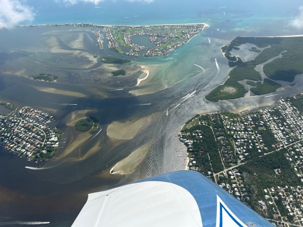


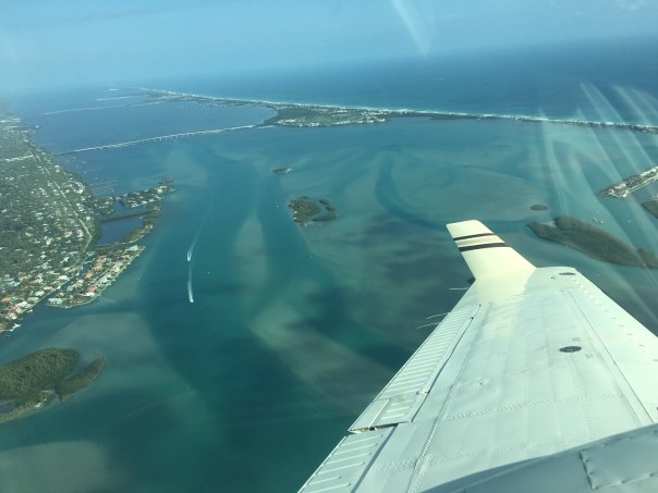


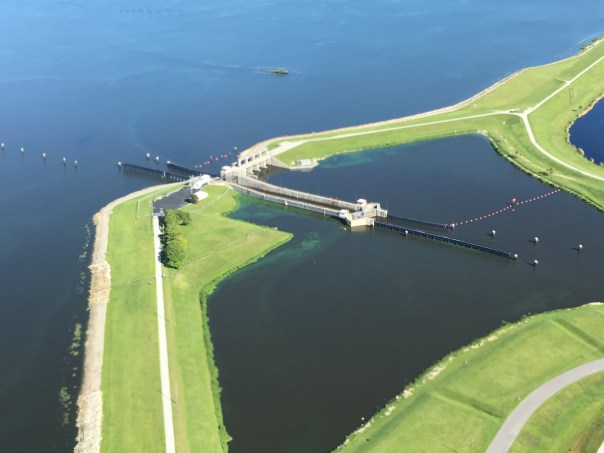


