Ed’s family came to visit. I was thankful the water was in good enough shape that Ed and I could take everyone out to enjoy the St Lucie River/Indian River Lagoon. The highlight for me was after a boat ride to Peck’s Lake, building a sandcastle with Capri (7) and Cole (5) at St Luice Inlet State Park.
With my hands in the earth at the side of the sea in a place of my childhood, it was as if nothing had changed. Except building the castle out of re-nourished beach sand maybe. But Capri and Cole did not notice.
Ours became a wonderful sandcastle, and together we cheered “We will not retreat” and kept building and adapting as the ocean moved ever-forward. I did not say a word, but thought perhaps I was preparing them for sea-level-rise. In the end, Cole took a shell to the wall and informed Capri and me that a “dinosaur had arrived to destroy the castle!” Capri was not happy; but I assured that it was “OK” as the nesting sea turtles preferred flat sand and would appreciate the tear down.
-Capri (7) Aunt Jacqui (57) and Cole (5)The next day, Ed took the family up for a flight.
It was Capri’s first time and although I was nervous due to temperature and turbulence, she was brave and her parents supportive. All was wonderful, but it did feel a little weird saying: “Capri, don’t be surprised when the giant Lake Okeechobee is bright green.” At seven years old, she gave me the largest of smiles and I smiled back. Then I turned to Ed saying “Babe, you may needed to talk about cyanobacteria (blue-green algae) when up in the plane.”
Ed nodded concentrating on the flight.
Never in a million years would I think to myself that this would be the conversation. In any case, Ben and Capri had a great flight! Kelli and Cole stayed behind with me.
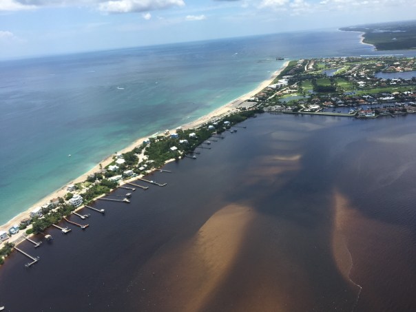
-Ed’s relatives. The Linder family: L to R. Ben, (nephew); Capri; Ed; Cole, & Kelli)-Ben, Capri, and Ed up in the airHere are some aerials of their flight, 7-2-21, 12: 57 pm:
-St Lucie River/Indian River Lagoon at Sewall’s Point, heavy local rain runoff, but no Lake Okeechobee releases.-S-80 St Lucie Locks and Dam, closed.-S-308 at Port Mayaca, Lake Okeechobee open for agriculture water supply but not going through S-80 to St Lucie River.-S-308, note algae inside structure leading to C-44 Canal.-Ed over Lake Okeechobee note age streaks and location of GPS near Clewiston.-Over western and central area of Lake Okeechobee -note GPS.Once we got home, there was no slowing down. Somehow the kids found Ed’s telescope up in the loft. Laughing, but embarrassed, Ed and I realized we had not taken it out in seventeen years!
We were able to look at a nearby oak tree, but not at the stars when they came out at night. The telescope had seen better days.
Even though we didn’t see the stars, it was adorable watching Ed with his niece and nephew. And I though to myself, “things have changed, but things really are the same and we must show the way to the next generation.”
-Ed works the telescope with Cole (5) and Capri (7) after the kids discovered it. -Capri looks towards the future…
Executive Order 19-12 “What can we do to achieve more now for Florida’s Environment?”
Sometimes all the bureaucracy of water management makes it difficult to understand how things work. Today, I am going to summarize the goals and requirements of Governor DeSantis’ Executive Order 19-12 Section 1, C. in hopes of giving some simple insight into the responsibility of our state agencies to publicly come together to achieve the Governor’s goal; there are only six months remaining.
On January 10th, 2019, just days after being sworn into office, Governor DeSantis put forth Executive Order 19-12. This order has multiple components, but today, we will focus on Section 1, C:
It states: “Update and secure all restoration plans, within one year, for waterbodies impacting Soth Florida communities, including Lake Okeechobee, the Caloosahatchee, and the St Lucie Estuaries. These updates will ensure the Blue-Green Algae Task Force has the necessary information to provide guidance to the Department of Environmental Protection on maximizing the investments in water quality improvements.
This means that the Basin Management Actions Plans, the system the state uses to try to improve water quality through lessening phosphorus and or nitrogen runoff have to be “updated” by January 10, 2020.
Prior to the Governor’s Executive Order 19-12, there was no unified update date, nor a clear deadline date. Why? Because state statute doesn’t give one. How come? Because over the years special interest has lobbied our state legislature to make it this way. Governor DeSantis’ order complicates this by giving a hard deadline to find out how these BMAPS are working or not working.
An update is an “update on the status of implementation at the end of the first phase and an opportunity to provide recommendations for future phases of the BMAP.”
The three Basin Management Actions Plans that need to be updated include the Okeechobee BMAP; the St Lucie BMAP and the Caloosahatchee BMAP.
The agencies that oversee this process are the Department of Environmental Protection (regulation of water quality standards); the Dept of Agriculture and Consumer Services (BMPs or Best Management Practices); and the South Florida Water Management District (water quantity or “projects)
You will see as you read about these BMAPS they are more of a soft than hard science. These maps were developed to meet a “total maximum daily load” reduction of phosphorus and or nitrogen, overtime – like 20 or 30 years!
To do this, basins and stakeholders are identified, and best management practices for agriculture and other stakeholders are implemented. Then the Dept of Environmental Protection models how much the best management practice will help remove phosphorus and or nitrogen and a certain amount of credit is given for using the Best Management Practice.
It’s kind of like giving a grade based on participation instead of performance. It’s time to raise the bar. In order for the Blue-Green Algae Task Force to have the necessary information to provide guidance to the Department of Environmental Protection on maximizing the investments in water quality improvements,” we must truly know the numbers.
~Monitoring not Modeling!
P.S. Why are the three BMAPs together in the executive order? Lake O is discharged into the St Lucie River and Caloosahatchee so for them to meet their goals, Lake Okeechobee has to meet its goals. For now, we are all connected.
“Florida’s Summer of Slime: Stuart and Lake Okeechobee,” photo essay by John Moran, August 2018
I reported last month on the plight of the Caloosahatchee River and its befouled waters flowing from Lake Okeechobee; delivering slime to waterfront neighborhoods in Fort Myers and Cape Coral along the way to the Gulf Islands of Southwest Florida.
Next up on our Summer of Slime photo tour is a visit to Stuart and Lake O…Stuart and environs is a glistening jewel born of water. It may well top the list of Florida cities in shoreline per capita. There’s simply water everywhere. Two forks of the St. Lucie River, the Indian River Lagoon, canals and peninsulas and islands, and the Atlantic Ocean beyond. Stuart is pictured above; below is neighboring Hutchinson Island.
But it wasn’t Stuart’s reputation for abundant clean water that drew me south from Gainesville with my cameras. In effect, I’ve become a traveling crime scene photographer—and slime is the crime. A devastating outbreak of toxic algae has once again hit the St. Lucie River and the Treasure Coast, fueled by the polluted waters of Lake Okeechobee and the Kissimmee River basin to the north. Damaging headlines trumpet the story to the nation and the world and Governor Scott has declared a state of emergency. It’s déjà vu all over again.
My hosts in Stuart were water blogger Jacqui Thurlow-Lippisch and her husband, Ed Lippisch.
Ed took me up for a photo flight in his Piper Cub so I could get the big picture.
Seen from a small plane at 500 feet, Florida is a beautiful place.
Here’s Lake Okeechobee and the western terminus of the St. Lucie C-44 Canal. Administered by the U.S. Army Corps of Engineers, the Port Mayaca Lock and Dam has the capacity to discharge 14,800 cubic feet of water per second downstream to Stuart and the St. Lucie River Estuary, 26 miles away.
Sugar industry representatives say the water coming out of Lake Okeechobee is not the problem and that the algae outbreak in Stuart is primarily caused by Stuart’s own septic tanks and urban stormwater. This claim is contradicted by the extensive algae mats seen along the C-44 Canal between the Port Mayaca and St. Lucie Locks, well upstream from Stuart.
Lake Okeechobee historically drained south to Florida Bay, not east and west to the Atlantic and Gulf. The C-44 canal was built in 1916 to divert floodwaters to the coast.
A view of the St. Lucie Lock and Dam, several miles southwest of Stuart. On the day of my photo flight in late July, the dam gates were closed, visibly holding back algae from flowing downstream. Look closely and you can see what some people call The Seven Gates of Hell.
The St. Lucie Lock and Dam are an integral part of South Florida’s complex web of water management structures, born of an age when the Everglades was reviled as a watery wasteland and America was driven to drain it.
Below the St. Lucie Lock and Dam, in Palm City and Stuart, you can still find waterfront homes untouched by the algae bloom. But that’s no consolation for the thousands of Martin County residents whose lives are in upheaval once again this summer. The familiar pattern of algae outbreaks is fueled by fertilizer, manure and urban sources of nutrient pollution, including septic tanks.
All of this is compounded by denial and neglect by elected officials and agencies to whom we entrust the important work of environmental protection and public health.
Jacqui Thurlow-Lippisch took me on a driving tour of the C-44 Canal from Stuart to enormous Lake O, which is more like a stormwater treatment pond than a biologically healthy lake. “There are toxic algae blooms across the globe, but only one place where the government dumps it on you: Florida,” she says.
It’s not just the algae from Lake Okeechobee causing headaches along Florida’s east coast; the sheer volume of freshwater discharges is an environmental pollutant that overwhelms the estuary.
The Lake O gunk visible in the satellite view, above, is shown in the detail photo below.
Fishermen are still drawn to Port Mayaca. On the day we visited, I counted nine.
Dinner in hand (speckled perch), Felix Gui, Jr. has been fishing Lake O for 30 years. “The algae doesn’t affect the fish,” he says. “They eat the same, algae or no algae, and I haven’t gotten sick.” Experts have warned against eating fish exposed to the algae.
A Martin County Health Department sign at Port Mayaca warns against contact with the water but I saw no messaging about whether fish caught in these waters is safe to eat.
Enroute home to Stuart, Jacqui and I stopped at deserted Timer Powers Park on the St. Lucie Canal in Indiantown.
At the St. Lucie Lock, a surreal scene of impaired water, above, and a vortex of slime, below, waiting to be flushed downstream.
A pair of jet-skiers signaled for the lock to be opened, and another pulse of algae-laden water is released towards Stuart and the coast.
Wouldn’t want to anyway, thanks.
Further downstream, the algae spreads…
Nearing the coast, Rio Nature Park and the neighboring Central Marine in Stuart are slimed again. This was the epicenter of the infamous Treasure Coast algae outbreak of 2016.
Reporter Tyler Treadway of TCPalm gathered a sample of the polluted water from a canal behind the offices of Florida Sportsman magazine in Stuart.
Staff complaints of headaches, nausea and dizziness prompted Florida Sportsman publisher Blair Wickstrom to temporarily close the office in late July. “It smells like death,” he said.
The Shepard Park boat ramp parking lot in Stuart was nearly empty on the day we visited.
A man on a mission, Mike Knepper, above and below, posts videos on his Youtube channel documenting the degradation of natural Florida.
“It’s totally unacceptable to me what we’re doing to this planet because we’re very rapidly destroying it,” Knepper says. “My children and grandchildren will be paying the price for all the bad decisions we’re making today. I want to be able to look them in the face and say, ‘I tried to make a difference.’”
Dead-end canals along the St. Lucie River with their limited water exchange have been hardest hit by the toxic blue-green algae, which scientists refer to as cyanobacteria.
A growing body of medical research links exposure to cyanobacteria with neurodegenerative diseases including Parkinson’s, ALS and Alzheimer’s. Google it.
Meanwhile, we’re getting conflicting messages from officialdom. Martin County has erected signs warning against contact with the water but the Florida Dept. of Health website, under the heading How to Keep Your Family Safe While Enjoying Florida’s Water Ways, has this to say: “Cyanobacteria/ blue-green algae…are naturally occurring in Florida’s environment and are also found all over the world. They are part of a healthy ecosystem and help support a wide variety of aquatic life.” (http://www.floridahealth.gov/environmental-health/aquatic-toxins/cyanobacteria.html) In other words, Lighten up, Florida. This is just nature being natural.
An open question remains: What will become of the value of the Florida brand when the world fully sees what we have done to our waters?
Even in disaster, strange beauty emerges.
Greg Fedele has lived in his water-front home since 1991. He grieves for his loss. “I have three kids who can’t enjoy the waterways of Martin County like I did growing up.”
The sign at Ocean Blue Yacht Sales in Stuart echoes a wide swath of community sentiment. Asked to describe in a word how the algae outbreak has impacted his business, president Bryan Boyd replied, “Horrible. The last three years, our bay boat sales have been a third of what they used to be.”
A roadside sign seen in Stuart in late July. If you’re wondering what you can do about the ongoing crisis of Florida waters, we are called to consider our own water footprint, learn about the issues and get involved. And never forget that elections have consequences. Vote for Clean Water. (https://www.bullsugar.org/#)
What we have here in Florida is not just a crisis of water, we have a crisis of democracy and civic engagement.
From the beleaguered springs of North Florida to the sickened rivers and coasts of South Florida, we must understand that no savior is waiting on the horizon who will fix this thing for us.
It took a group effort to create this mess and we need all hands on deck if are to reclaim our waters. Florida needs environmental patriots willing to face down politicians funded by wealthy interests who think nothing of sacrificing our public waters on the altar of their private profits.
We don’t have the luxury of time to get this right. We are losing our waters now. This is our moment. It’s time to set aside our differences and focus on what is at stake, for this is nothing less than a battle for the soul of Florida.
The pictures don’t lie. We the people of Florida bear witness today to nothing less than a crime against nature, and a crime against the children who shall inherit our natural legacy.
A long time ago, Florida political leaders—Republicans and Democrats in common cause—understood there can be no healthy economy without a healthy environment. They wisely enacted laws and regulatory safeguards accordingly.
But that was then and this is now. It’s time to end the popular fiction in Florida that we can plunder and pollute our way to prosperity.
Gov. Reubin Askew said it best when he declared in 1971, “Ecological destruction is nothing less than economic suicide.”
Feel free to forward or post this photo essay as you wish; attribution is appreciated. Please share this with elected officials and ask them: what’s their plan to clean up our waters?
If you feel anything like me, you’re not just tired, but sick of heart from looking at dead animals. The atrocities of our estuaries this year, especially for the Caloosahatchee, are Armageddon like in nature.
It is natural to be saddened, but we must stay strong and find inspiration. When we look around, even on the bloody environmental battlefield, it is there.
Today, I share the beautiful photos of local St Lucie River photographer Stephen Duffy, his Anhinga series shows this symbolic bird in all its glory. These special, yet common birds have no oil on their feathers, so they can both swim underwater and fly above the Earth. Thus the Native People held them sacred. ~The bird that can fly and swim. The bird that can do “anything.” The bird that breaks the wall of water and sky.
When you see the anhinga remember: fly, swim, break through walls, and most important, believe.
Today, at a Rivers Coalition meeting, Army Corp of Engineers, Lieutenant Colonel Jennifer A. Reynolds, announced unexpected news: the ACOE will stop discharging to the St Lucie River for 9 days and then resume. They have been releasing from S-308 for four days since a past weekend pause…
This halting, considering it appears to be at least partially a response to an almost completely cyanobacteria filled Lake Okeechobee, and though temporary, is a significant federal decision in the documentation of toxic/algae/St Lucie issues.
The meeting began with Martin Health CEO, Rob Lord discussing health concerns of contact with blue-green algae, and ended with LTC Jennifer Reynolds showing herself to be among other things, a gifted communicator. Please watch the videos for details of this day.
The Jacksonville District of the ACOE will be announcing its next three-year positions for Colonel and Lieutenant Colonel in the coming weeks or months. This cycle of short-lived leadership makes developing lasting relationships and, thus change, indeed almost impossible. But days like today, give one hope.
Mark Perry, Florida Oceanographic, & RC Leadership Team leads meetingThe River Kidz give a report on their trip this week to Washington DC participating in “Lagoon Day,” sponsored by Congressman Brain Mast. Nine young people traveled and met with multiple leaders including: Congressmen Mast, Graves, Shuster, ACOE Col. Kirk, & Senators Nelson and Rubio.Todd Weissing speaksAllie Preston ask a questionLTC Reynolds
I am posting this, not because I want to but because I have to. I much rather be enjoying the day instead of once again sitting at my computer. But time is of the essence.
This morning I read a comment by TcPalm reporter, Ed Killer, on Facebook stating the ACOE’s pulse release schedule for the St Lucie River.
If this is true, and with Ed Killer posting, I believe it is, the ACOE will start releasing again Monday, 6-25-18. I did not know this until I read his post.
Today, my husband Ed and I were flying other people over Florida as usual, and during our flight I took this video expecting maybe some algae in C-44 but instead also found the gigantic bloom against the gates of S-308 in Lake Okeechobee leading into C-44/SLR.
So I wrote on Facebook:
I am so over this, but cannot fail to report. According to Ed Killer ACOE will start discharging from Lake O tomorrow in spite of Governor’s Emergency Order. Look at this algae mess waiting at gates of Port Mayaca. Write ACOE’s LTC Jennifer Reynolds and politely ask for ACOE to wait and to have DEP test again: jennifer.a.reynolds@usace.army.mil (JTL-S-308 video taken 6-24-15 at 12pm) #toxic2018
As Monday is tomorrow, and I fly to DC with the River Kidz tomorrow, I am posting this now. I truly believe considering the circumstances, that the ACOE should refrain from discharging at S-308 or S-80. And the state’s FDEP (Florida Department of Environmental Protection) should have this water tested, again, as bloom has changed.
To just dump this on the people of Martin County along the St Lucie River is a crime.
Respectfully,
Jacqui
PLEASE WATCH THE VIDEO
The recognizable shape of S-308 the entrance to C-44 and the SLR. Lake O’s connection to the river—obvious massive algae bloom at gates.Bloom as satellites show is throughout and scattered in lake. This shot is looking more towards middle of lake in southern area.
Entrance to Caloosahatchee on west side of lake and near Clewiston Bloom is all through lake.
I could never do what I do without the people who help me. My husband, his pilot friends, the everyday people sending me “toxic-algae” imagery, the River Warriors community, and when it comes to striking the bull’s-eye, my science-studied-lawyer, little brother, Todd.
Just hours ago, Todd forwarded these images from satellites, Landsat 7, and Sentinel 2, clearly showing a large algae bloom photographed yesterday in Lake Okeechobee. 102 square-miles of it!
So Florida state agencies, and others…
…Do not tell me the algae comes from our river. It does not. We have been through this before….
The algae, that can become toxic, and maybe already is, starts in, and comes from the crock-pot of Lake Okeechobee. The Army Corp of Engineers should stop discharging right now. Right when the Colonel sees these images. And these images have been seen, because NASA makes these images available to the Corp.
When a satellite image like this is made public, it cannot be ignored.
The ACOE should close the gates of S-308 until DEP has tested all edges of this large bloom. And work for never discharging when there is an algae bloom in Lake Okeechobee.
Stop the discharges from Lake Okeechobee!
LE07_L1TP_015041_20180614_20180614_01_RT-cropSentinel-2 L1C from 2018-06-15Sentinel-2 L1C SWIR from 2018-06-15Sentinel-2 L1C NDVI from 2018-06-15Sentinel-2 L1C SWIR crop from 2018-Sentinel-2 L1C NDVI crop from 2018-06-15
Since my husband, Ed, accidentally spotted an algae bloom in Lake Okeechobee, while running new engines on the Baron, I have posted many photos on Facebook and the word is out.
Nonetheless, for purposes of documentation, I am going to post some of the photos again on my blog for historical purposes and for those who do not use Facebook.
~Ed noticed the “lines of algae” in the lake on June 2, two miles or so northwest of Port Mayaca, the day after the ACOE started discharging from Lake O into the St Lucie River. Absolute chance, fate, or a tip from above, however you decide to look at it.
Since this time others have documented on the ground and DEP should be testing for toxicity.
So, after seeing the bloom on Friday, Ed went back the following day on Saturday in windy conditions so I stayed home–in the yellow plane, the Cub, getting more pictures of bloom, looking about the same but more dispersed from rain perhaps. These photos at lower altitude also include drainage structures around the lake, as well as the destruction of the St Lucie River/Indian River Lagoon at Sewall’s Point and the St Lucie Inlet.
Photos will continue to be taken as we once again, document the discharges, and once again have seen first-hand, like we did in 2016, without the warning of our government, that the algae that contaminates the St Lucie River starts in Lake Okeechobee.
The fact that Lake Okeechobee, the St Lucie River, and other water bodies of our state are in such poor condition puts the state of Florida “between a rock and a hard place.” After all, for centuries just saying the word “Florida” conjured up visions paradise…
Early rendition of the Everglades area including the rivers of the SLR/IRL. (Thurlow Collection.)Cyanobacteria, that often becomes “toxic algae,” is bad for business. In fact, perhaps nothing is worse for business. It is also bad for people’s health. Hmm? How does the state report toxic algae and fulfill their responsibility for safety without scaring people away? And without hurting business?
The answer is of course that “you really can’t…” But you can be honest and take leadership. You can turn a bad situation into a good one, because after all, a very powerful force of human nature is a common enemy.
Cyanobacteria, toxic algae, is our common enemy. For ALL of us.
The state has known that Lake Okeechobee has been eutrophic (prone to algae blooms) since at least the 1960s–the time of my birth. Early documentation from the state Geological Societies and Water Management Districts clearly documented the over nutrification of the lake, due to agriculture and development’s run-off exacerbated by channelization of rivers, lakes, the draining of lands, later the spreading of bio-solids (treated human waste) on fields, and a population explosion.
It is time to start diligently approaching the reporting of algae blooms and tracking their sources. There is a lot of area to cover; we can’t just test from the side of the road. Algae is living and changing and morphing every second. It is worth the investment to monitor it for what it is, an enemy. 24 hours a day…
Today I am again honored to feature the writing of Professor Geoff Norris. This most recent work is a tremendous achievement of time, research, and puzzle piecing. Professor Norris’ past shared articles “Blue Green Algal Blooms in the Lakes, Rivers, and Marine Waters of South Florida Surrounding Lake Okeechobee,” and “Sugarcane and Indians” were extremely popular with many of my readers. Professor Norris has a way of communicating complex topics in an easy and interesting way so that everyone can understand and make the connections. In the 1960s Professor Norris lived and worked as a petroleum exploration geologist in Tulsa, Oklahoma. Subsequently, he spent 40 years at the University of Toronto teaching and performing research in geology. A geologist by training, Professor Norris has a specialized knowledge of fossil algae, their ecology, morphology, and distribution. He has published hundreds of scientific papers on fossil algae and related topics…I encourage you to contact him by email with any questions at rosalex@interlog.com
Thank you Professor Norris. “Together we will create a “better water future!”
Jacqui
Lake Okeechobee blue-green bacterial blooms in Florida: lessons from Lake Erie
In the following article, I have attempted to summarize some of the voluminous literature on Lake Erie and its problem blue-green blooms, and how this might help to understand similar events in Lake Okeechobee. I have included URL web addresses for some of the topics, which can be used to access further information.
Although the blooms are often referred to as blue-green algae, this is quite inaccurate and I can see no further point in perpetuating this misnomer. The blooms are largely or entirely composed of Cyanobacteria, or blue-green bacteria as I have chosen to call them for this article. This is not just for precision and to point up their lack of a nucleus and other organelles in each cell, but serves to underline how these organisms earn a living and perpetuate themselves that is quite different compared to nucleated organisms, the latter including algae, fungi, all green plants, and all animals. This difference is really important.
The topic is vast and my review barely scratches the surface – it’s not meant to, because I am not an expert and am still trying to understand the vast complexity of blue-green bacterial bloom formation. I have tried to unravel and clarify some of the science and scientific investigations that have been important for me, and have used these as examples of the work that is going on or has led to current advances. For every paper I have cited, however, there could be tens or hundreds more that haven’t been consulted or mentioned. I apologize in advance to those many talented scientists that I haven’t mentioned or that I am simply unaware of.
Steel Town
I used to live in Hamilton, Ontario, a prosperous city with thriving iron and steel mills, other manufacturing industries, an excellent university and a great football team, a sort of Pittsburg of the North. It sits on the shores of Lake Ontario on a sliver of land – the Niagara Peninsula – that separates Lake Erie from Lake Ontario. In the early summer after the ice had melted, many of the locals in the mid-1900s would take advantage of the beaches along Lake Ontario to sun themselves and wait until the water was warm enough to swim in. However, you could get a head start on summer by taking a short drive south (less than an hour) to the beaches along Lake Erie where the water was warmer earlier in the summer, and resorts and tourism thrived. Fish were abundant and the lake was very productive for commercial fishing and equally attractive for sport fishing. The beaches were superb for tourism and sun lovers. Lake Erie is large but shallow (average depth about 60ft) and so a baby on a Great Lakes scale from a volumetric point of view (most of the Great Lakes are hundreds of feet deep, the deepest being Superior at more than 1300 ft maximum depth). However, Lake Erie’s smaller volume and shallow waters helped it to warm up quickly in the spring and summer.
The Dead Sea of North America
Then something happened to Lake Erie, starting in the 1960s. The water of Lake Erie became murky and discolored, mass fish kills led to piles of rotting marine life polluting the beaches, the tourists and anglers and sun worshippers stayed away in droves, the resorts closed down, the commercial fisheries were badly hit, and the economy suffered enormously. Algae were blamed but no one was quite sure why they had become so abundant – “eutrophication” was the buzzword of the time. Lake Erie was declared “dead”, which was quite inaccurate since it was swarming with life, but the wrong sort of life. The culprits polluting the environment were a mixture of true green algae (such as Cladophora) and so-called “blue green algae” (such as Microcystis and Aphanizomenon), which in truth are types of bacteria using chlorophyll and other pigments that allow them to live in sunlight (their technical name is Cyanobacteria –called blue-green bacteria in this article), and this is discussed in more detail in my previous blog: https://jacquithurlowlippisch.com/tag/dr-geoffrey-norris/). The plight of the Dead Sea of North America (as Lake Erie became known) was so notorious that one of Dr Seuss’s books for children – The Lorax (1971) – made reference to it in his famous style of doggerel:
You’re glumping the pond where the Humming-Fish hummed!
No more can they hum, for their gills are gummed.
So I’m sending them off. Oh, their future is dreary.
They’ll walk on their fins and get woefully weary
In search of some water that isn’t so smeary.
I hear things are just as bad up in Lake Erie.
The Fix
Very fortunately the mystery of Lake Erie’s “death” was soon solved, thanks to a treaty between the U.S. and Canada dating back to the early 1900s that acknowledged the need to maintain water quality in the Great Lakes’ waters bordering the two countries.
By the middle of the 20th century this had morphed into the International Joint Commission for the Great Lakes. These international efforts were underpinned by government and university-based research in both the U.S. and Canada, which identified phosphorus entering the waters as a major contributor, particularly from agricultural fertilizers on the one hand and from domestic laundry detergents on the other. In 1972 the Great Lakes Water Quality Agreement (GLQWA) was signed between the United States and Canada, by Prime Minister Pierre Trudeau for Canada and President Richard Nixon for the United States. They loathed one another personally, but they knew what was the right thing to do for their countries.
Prime Minister Pierre Elliott Trudeau and President Richard Nixon signing the Agreement.
The Agreement emphasized the reduction of phosphorous entering lakes Erie and Ontario, and, in 1977, maximum levels for phosphorous were added to the Agreement. Also, phosphorus in laundry detergents was finally drastically reduced or banned. Coupled with the U.S. and Canadian Clean Water acts, the International Joint Commission did much to reduce the phosphorus levels in Lake Erie.
International Joint Commission (IJC): “More than a century of cooperation protecting shared waters. Canada and the United States each appoint three of the six IJC Commissioners, including one chair from each country. The two chairs serve concurrently.The Commissioners are appointed by the highest level of government in each country, but once appointed they do not represent the national governments; they operate at arm’s length.The Commissioners traditionally work by consensus to find solutions that are in the best interest of both countries. The Commissioners are supported by U.S. and Canadian Section offices in Washington, D.C. and Ottawa, Ontario.”
So everyone breathed a sigh of relief, phosphorus levels went down, farmers applied fertilizers to their fields differently, consumers chose phosphorus-free detergents, municipalities improved their storm water and sewage treatment facilities, the fish and other wildlife came back to Lake Erie, and Dr Seuss was persuaded to remove the last line in his poem. Further details can be found in a report by the National Wildlife Federation:
For almost 20 years, Lake Erie was not plagued by the blue-green bacteria problem, but other problems did emerge such as exotic zebra mussels that interfered with the distribution of elements important in nutrition, but they seemed at the time to be unrelated to bacterial infestations. Then starting in the mid-1990s, the blue-greens reappeared and became progressively worse leading to super-gigantic blooms that choked the western end of Lake Erie with green muck inches thick and hundred of square miles in extent. Dead zones – biological black holes – reappeared in the Lake as the rotting organic matter sucked the oxygen out of the water, promising certain death to animals that ventured in.
In the summer of 2011 the mother of all blue-green bacterial blooms exploded in Lake Erie, the bloom at its peak being more than 1900 square miles in extent. That is more than 50% greater than the entire state of Rhode Island, or 35% larger than Long Island, or more than six times larger than all of New York City’s five boroughs. This super-giant bloom had an estimated weight of 40,000 metric tons dry weight. The wet weights of algae and blue-green bacteria are generally at least 10 times the dry weight. So, this supergiant bloom had at least half a billion tons of blue-green bacteria living within it – a true monster.
MODIS (Moderate Resolution Imaging Spectroradiometer) satellite Image of Lake Erie on September 3, 2011, overlaid over map of Lake Erie tributaries. This image shows the bloom (in green) about 6 weeks after its initiation in the western basin. From Michalak et al, 2013.
These blooms had a devastating effect on the areas flanking the western end of Lake Erie – Ohio, Michigan, and Ontario – with large agricultural areas and several major cities and industrial towns. Toxins from the blue-green bacteria polluted the drinking water supplies of large cities, and potable water had to be trucked in for the residents.
The “greening” of Lake Erie has been documented by Prof. Tom Bridgeman of the University of Toledo in a presentation:
In his presentation Prof. Bridgman showed how increasing phosphorus in the lake water favored the blue-green bacteria and shut out the normal tiny floating plants (true algae), a situation that had culminated in the American Dead Sea catastrophe of the 1960s. The international agreement on phosphorus reduction in the Great Lakes was a huge success story for Lake Erie, but by the mid 1990s algal biomass was beginning to increase again (eutrophication was returning), and by the early 2000s blue green bacteria such as Microcystis were increasing ten-fold, as the reactive phosphorus in the lake waters increased beyond levels recorded in the 1970s.
What the heck was going on here? Everyone had played their part in reducing phosphorus run-off from agricultural lands, and the municipalities and citizens had cleaned up their act. So where was the phosphorus coming from? Well now the plot thickens.
Farming and Phosphorus
This time, the main problems are thought to be ones that governments have much less direct control over, according to a file posted by Emily Chung of the Canadian Broadcasting Corporation News (2014).
To some extent, they include the application of fertilizers to lawns and golf courses, growing expanses of pavement in urban areas that cause water to drain more quickly into waterways without being filtered by vegetation, and invasive zebra mussels that release extra nutrients into the water as they feed. But those aren’t thought to be the biggest cause.
“We think farming is the major culprit behind the current levels of phosphorus that’s in runoff and the phosphorus loads that are getting dumped into the western basin of Lake Erie,” said Dr. Glenn Benoy (senior water quality specialist and science adviser with the International Joint Commission in Ottawa).
Dr Glenn Benoy
So why is this? Well, there are several things going on. Firstly, corn production is at an all time high because of the push to increase alcohol biofuel production, and soybeans are being produced in gigantic quantities for use as animal feed, oil and protein for human consumption, plastics and biodiesel. Secondly, the introduction of no-till farming practice in the U.S. has led to increased run-off of fertilizer. Thirdly, there’s just not enough infrastructure to deliver in the spring the huge amounts of fertilizer that are required by the corn farmers. Prof. Ivan O’Halloran of Guelph University, Ontario and a specialist in soil fertility and nutrient use commented that the demand by corn farmers is such that there are simply not enough rail cars to satisfy the need. So companies offer discounts to farmers who are willing to apply fertilizer in the fall, which in turn leads to enhanced run-off of phosphorus during the winter storms.
Prof. Ivan O’Halloran
No-till Farming and Glyphosate
And then there is the matter of no-till farming. No-till farming (also called zero tillage or direct drilling) is a way of growing crops or pasture from year to year without disturbing the soil through tillage, and in current practice depends on the use of powerful herbicides such as glyphosate (Monsanto’s Roundup brand being the most popular formulation). Application of glyphosate kills weeds and other vegetation in preparation of the seedbed. Later in the year, another application of the herbicide is used to reduce weeds that might be harming the crop. However, this is only possible if the farmers use genetically modified seeds that are resistant to glyphosate – often referred to as Roundup Ready seeds. In 2014 in the U.S. 98% of soybeans and more than half of corn was Roundup Ready. Advocates of Roundup point out that glyphosate is a compound derived from phosphonic acid in which the phosphorus is strongly bonded to carbon and therefore is not available to plants, unlike fertilizer which contains phosphates (not phosphonates) which has phosphorus bonded less strongly to oxygen, and is therefore more readily available for uptake by plants (often referred to by the acronym DRP – dissolved reactive phosphorus).
Prof. Chris Spiese is a chemist at Ohio Northern University and he decided to test the contribution that glyphosate might make to the amount of dissolved reactive phosphorus running off of cultivated fields. He found that glyphosate acts on the soil to allow the phosphorus bonded to the soil (either being naturally present or due to fertilizer use) to be released by the chemical process known as desorption. He also found that soils richer in both iron oxides and iron hydroxides tend to release by desorption more phosphorus, as do soils that are more acidic. Overall, he calculated that glyphosate is responsible for releasing 20-25% of the dissolved reactive phosphorus in the Maumee watershed, a river discharging into the western end of Lake Erie. Prof. Spiese calculated that for every acre of Roundup Ready soybeans, one-third of a pound of phosphorus comes down the Maumee River. In 2010, according to the Ohio Soybean Council, 4.6 million acres were planted in soybeans, of which about 2 million acres of soybean fields drain into Lake Erie.
If Prof. Spiese’s calculation for the Maumee watershed hold true for all the soybean acreage in Ohio draining into Lake Erie, this would suggest that each year hundreds of tons of dissolved reactive phosphorus are entering the Lake from this source alone. And then there are the other states and provinces bordering Lake Erie that are also involved in soybean production: Ontario 2 million acres; Michigan 1.5 million acres; NW New York, 1/3 million acres; Pennsylvania 1/2 million acres. Of course, not all these agricultural lands drain into Lake Erie but these numbers give some idea of potential dissolved reactive phosphorus input related to soybean production alone.
The Monster Revisited
The super-giant blue-green bacterial bloom of 2011 in Lake Erie required a concerted response from the scientific community to understand just why this had happened. There was no doubt in scientists’ minds that dissolved reactive phosphorus as run-off from agricultural land was a major factor. But why should a super-giant bloom happen in 2011 and not in 2012 when the same agricultural land and its phosphorus run-off were still flanking the Lake and continued to be a constant factor? Something else was involved. So an elite team of scientists from universities, government laboratories, and industrial laboratories got together to investigate, headed up by Prof. Anna Michalak of Stanford University.
Prof. Anna Michalak
In 2013 this team of 29 scientists came up with their report, which was published in the prestigious Proceedings of the National Academy of Sciences.
The team concluded that long-term trends in agricultural practices (e.g. no-till farming) plus increased acreage under intense cultivation (notably soybeans and corn) led to a major pulse of phosphorus into Lake Erie during some unusually intense spring rainstorms in 2011. Then in the late spring and summer unusually quiet but warm weather conditions provided just the right conditions to seed, incubate and grow the bloom in the waters of Lake Erie. The team stated “If a scientifically guided management plan to mitigate these impacts is not implemented, we can therefore expect this [super-giant blue-green bacterial] bloom to be a harbinger of future blooms in Lake Erie.” – because unusual weather events, lower wind speeds, warmer waters, and higher rainfalls are becoming more common and can be expected in the future.
Glyphosate and Blue Green Bacteria
Recent work by scientists at Bowling Green State University has reported the presence of glyphosate in Lake Erie. It is evidently washing out of the no-till crop fields, and reaches a maximum in the summer months. Also it has been found in water treatment plants, peaking in the summer months. Prof. McKay and his colleagues raised the possibility in 2010 that the presence of glyphosate in Lake Erie together with phosphates from fertilizers tend to stimulate the growth of blue-green bacteria, whereas phosphates alone do not do this but favor diatoms, a normal algal component of Lake Erie. It seems that blue-green bacteria can utilize the phosphorus in the glyphosate, which was believed to be otherwise not normally bio-available. Many questions remain to be answered but the intense use of glyphosate in the area around Lake Erie demands rapid action in the very near future to establish just how much glyphosate is involved in blue-green bacterial blooms.
An even more disturbing piece of microbiological and genetic research was done by Prof. Victoria López-Rodas in Madrid together with other Spanish colleagues in 2007. They studied Microcystis, one of the bad boys of the blue-green bacteria family. They found that rare mutations during growth and division of cells could clone a glyphosate-resistant strain that could survive in glyphosate polluted waters. In other words, Microcystis has the potential to develop into a “superbug” unaffected by glyphosate. The odds of a mutation like this occurring were calculated to be a few times in 10 million by Prof. Lopez-Rodas’ team. That’s better than the odds for winning the Jackpot in the Florida Power Ball Lottery (1 in 292 million), but still not great. If you bought hundreds of millions of ticket in the lottery, you would have a good chance of winning at least once, perhaps several times (but at $2 a ticket you financial advisor might have some things to say to you about your investment strategy). However, given a little phosphorus and nitrogen, Microcystis can keep on dividing trillions and trillions of time to form blooms in warm water. With such astronomical numbers, a rare mutation becomes a virtual certainty at some point during cloning, and in the presence of an antibiotic such as glyphosate, a superbug is born.
So far the emphasis has been on phosphorus and how it is important in blue-green bacterial bloom formation. But nitrogen is also very important as a nutritional component for blue-greens and indeed for all life. Green plants need nitrogen to synthesize proteins and other important components in their cells. Although nitrogen is abundant in the atmosphere, it is an inert gas and simply unavailable as a nutrient for many green plants. It needs to be combined with hydrogen (as an ammonia compound) or with oxygen (as a nitrate compound) to be absorbed by the plant. These nitrogen compounds may be naturally occurring in soil, but in agricultural land they need to be added frequently as fertilizer for crops to thrive.
Blue-green bacteria have an advantage over green algae and other green plants because some blue-greens have the ability to synthesize nitrogen compounds directly from gaseous nitrogen – they are said to be able to “fix” the nitrogen. But some other blue-green bacteria are unable to fix the nitrogen and have to depend on another source. Microcystis is a case in point (the blue-green bacteria that are often dominant in the giant blooms in Lake Erie and Lake Okeechobee). Microcystis is highly dependant on a source of nitrogen to thrive. This can of course be provided by run-off from crop fertilizer, but it does not always explain the fluctuations of this and other blue-green bacteria that have or do not have nitrogen fixation ability in Lake Erie, in spite of the fact that the experts all agree that phosphorus – not nitrogen – is the principal limiting factor.
Lucas Beversdorf and colleagues at the University of Wisconsin decided in 2010 to try and solve the problem and improve predictability of toxic blue-green episodes in a beautifully designed and detailed study of Lake Mendota, Wisconsin a much smaller lake (15 square miles) than Lake Erie but about the same depth and with similar temperate seasonal weather patterns.
They found that Microcystis (blue-green non-nitrogen fixer) rode on the back of Aphanizomenon (blue-green nitrogen fixer) in a nutritional sense. Without the nitrogen fixer doing its work first in the spring, Microcystis as a non-nitrogen fixer could not attain dominance and pollute the water with toxic microcystin in the summer. This could be relevant to understanding how the blooms that occurred in the mid-20th century in Lake Erie came about, both Microcystis and Aphanizomenon being important contributors to large blue-green blooms at that time. It could also be important in predicting when blooms can be expected.
Prof. Karl Havens, a biologist at the University of Florida (and formerly of the South Florida Water Management District) has discussed the implications of nitrogen and phosphorus as nutrients for blue-green bacteria in Lake Okeechobee, and the need to reduce both given the physical and biological complexities in a shallow lake.
It has been known for some time that non-nitrogen fixing bacteria are highly competitive when it comes to ammonium compounds in freshwater lakes, possibly explaining why Microcystis and similar blue-green bacteria do achieve dominance in the blue-green blooms when in proximity to agricultural run-off.
Researchers are looking for ways to monitor assess and predict algal blooms of all types. This can be done by sampling the lake waters and analyzing them for various organisms and chemical compounds, such as Dr Beversdorf did for his detailed study of Lake Mendota. However, in very large lakes such as Lake Erie the shear size of the lake makes rapid response to a growing giant algal bloom impossible.
Prof. Joseph Ortiz of Kent State University, Ohio has been actively involved in developing new ways to gather information on giant blue-green bacterial blooms using an instrument on board the International Space Station. From space it can image all of Lake Erie in two days – remember Lake Erie is about 9,900 square miles (241 miles long, 57 miles wide). He uses a technique called hyperspectral visible derivative spectroscopy, quite a mouthful but very important. The hyperspectral imager works in orbit about 220 miles above the Earth’s surface and transmit the results to Dr Ortiz who uses sophisticated analytical methods to identify various types of algae and bacteria in the lake water.
This and related techniques are now being used to forecast blue-green bacterial blooms, in cooperative ventures between NASA and NOAA (National Oceanographic and Atmospheric Administration). For example this was their forecast summary for 2014:
“This year’s forecast is for a western basin Lake Erie cyanobacteria bloom of 22,000 metric tons dry weight (MT), with a 95% predictive interval of 11,000 to 33,000 MT. The bloom size over the last decade (2004-2013) has averaged 14,000 MT, such that this year’s bloom will likely be above average. However, the 2014 bloom is expected to be less than the record bloom of 40,000 MT, which occurred in 2011.”
In August of 2014 the City of Toledo shut down its water supply because of contamination by blue-green bacterial toxins (microcystin), which made it undrinkable for 400,000 residents, confirming the astonishing power of this predictive method.
A Florida Mismanagement Plan for Niagara Falls
Just imagine if the same planning “logic” had been applied to Lake Erie as has happened with Lake Okeechobee. In the case of Lake Okeechobee, agricultural interests took over an Everglades river and associated sawgrass wetlands to drain them for use as sugar plantations. To do this the ancient course of an Everglades river was disrupted by damming its 25-mile wide outflow from Lake Okeechobee, upstream from the Everglades Agricultural Area. In so doing the lake level rose because it had no other natural outlet. Therefore higher shoreline dike construction was needed (the Herbert Hoover Dike) to impound the water to prevent flooding of the adjacent land. All this destroyed a large part of the Everglades, a natural wonder of the world designated an International Biosphere Reserve and a World Heritage Site by UNESCO and a Wetland of International Importance. The “river of grass” in the Everglades became starved for water.
Everglades River of Grass
Meanwhile, the Kissimmee River feeding into Lake Okeechobee and draining another agricultural area was straightened and canalized to remove those annoying meanders that characterize river systems as they approach local base level (the lowest point to which a river can flow). The straightened channels thus allowed rapid fertilizer run-off from the fields, preventing filtering and bio-cleansing in the natural wetland vegetation of the flood plain meanders that would otherwise exist, further contributing to heavy phosphorus loading in Lake Okeechobee and the consequent blue-green bacterial blooms. The straightened channels also contributed voluminous extra water that the lake could not handle. Therefore, the lake managers and flood controllers (the Army Corps of Engineers) directed the overflow waters down a number of canals with outlets to the highly populated Atlantic and Gulf coastlines and the sea, the overflow water being heavily polluted with blue-green bacteria from the giant blooms that grew in the lake.
So let’s work this through for our imaginary Niagara Gorge Agricultural Area, a 7-mile stretch that would be ideal land for growing grapes and other fruits in a valley just below Niagara Falls. Once drained, the imaginary agricultural area would eventually develop lime-rich soils, which would be perfect for high quality wine grapes, and would be similar to the soils in the adjacent Niagara Wine Country. The fruit would be sheltered from the worst of the Canadian winter that might otherwise be unfavorable for growing and ripening the grapes. There would be one big problem: there is too much water in the Niagara Gorge, which transports the Great Lakes waters through the Niagara River into Lake Ontario.
So, the imaginary managers deemed that a dam would be necessary across the Niagara River upstream from Niagara Falls to divert the water elsewhere, and help to drain the Gorge. They knew this would be entirely possible because the Army Corps of Engineers had dammed the Niagara River once before to make repairs to the Falls, back in 1969. Of course, the magnificent Niagara Falls, a real wonder of the world, would cease to exist. Meanwhile, the Lake Erie water level would start to rise and bigger and better dikes would be needed, particularly around population centers such as Buffalo, Cleveland, Toledo, and Detroit, to prevent flooding. This in turn would raise the base level of the inflowing rivers and they would back up and tend to flood more frequently. The imaginary managers decided to straighten the meander channels of the rivers to allow quicker drainage, but this in turn sent a high discharge of agricultural phosphorus run-off into the Lake. The higher loading of phosphorus triggered gigantic blue-green bacterial blooms.
Clearly an outlet would be needed for the imaginary re-engineered Lake Erie high-level water, so the imaginary lake managers decided to discharge the lake water somewhere else. Very fortunately, an older structure – the Erie Canal – still existed and would be ideally suited for modification to act as a spillway or overflow channel. The Erie Canal in turn would channel the water from Niagara into the Hudson River and out into the Atlantic Ocean near New York City. Unfortunately the voluminous discharge of polluted freshwater from the Lake would do two things. First, the blue green bacteria would thrive as the discharge water slowed and became semi-stagnant in the estuaries and coastal regions around Manhattan during the summer. Secondly, the marine wildlife would be severely impacted due to the drastic reduction in salinities by mixing with freshwater. This would lead to the mass death of marine life, together with animals and plants that thrive in marginal marine and brackish environments such as oysters and clams. Millions of New Yorkers and those in adjacent areas would become enraged because the grape and fruit growers in the Niagara Gorge Agricultural Area have caused all this in the first place, due to their insistence on the change of land usage. Meanwhile, the farmers in the newly established Niagara Gorge Agricultural Area are thriving and unaffected by these changes, and blame the towns and cities for inadequate sewage treatment and leaky septic tanks.
Of course, all this is nonsense and absurd – a figment of my imagination. It wouldn’t happen in real life, would it? No one could be that inept or uncaring – or could they?
The chances of such a catastrophe happening in real life are very slim in the Niagara region. Any move by a special interest group planning to monopolize a Great Lakes’ resource would come under the immediate scrutiny the International Joint Commission. In all likelihood they would jump on such a rapacious scheme like a ton of bricks and it would never see the light of day.
It’s a great pity that the people of Florida don’t have an equivalent body with overarching responsibility for maintaining the quality of Florida waters for all Floridians. Unfortunately, sensible planning initiatives over the decades have been circumvented, and most state politicians have been incapable or reluctant to fund policies directed towards protecting Florida’s water resources. It is a dismal story of failure to protect Florida’s natural resources, and continues to be fueled by campaign contributions from Big Sugar to Tallahassee. The more-than-century-long story has been insightfully summarized recently by Jaclyn Blair, a law student at Florida Coastal Law School, Jacksonville, graduating this year (2017) as Juris Doctor. It is recommended reading for anyone wanting to understand the various parts played by corporate interests, citizens concerns, politicians, policies, legalities, and constitutional amendments regarding the destruction of Florida’s natural resources.
I didn’t think up this sub-header, but thanks to PBS for producing a video of that name. In 2007 PBS published this synopsis of their program:
“During the past 125 years, a series of well-intentioned decisions, actions and policies have turned what should have been one of Florida’s greatest natural treasures into an environmental villain. Six thousand years later after if was formed, residents and agencies across the state are now raising the questions: Is it too late for Lake O?”
In 2017 the question is still valid.
Let’s start with the Manager of Lake Okeechobee, the South Florida Water Management District (SFWMD), which describes itself as follows in its mission statement:
“OUR MISSION: To manage and protect water resources of the region by balancing and improving flood control, water supply, water quality and natural systems.
The South Florida Water Management District is a regional governmental agency that manages the water resources in the southern half of the state, covering 16 counties from Orlando to the Florida Keys and serving a population of 8.1 million residents. It is the oldest and largest of the state’s five water management districts. Created in 1949, the agency is responsible for managing and protecting water resources of South Florida by balancing and improving flood control, water supply, water quality and natural systems.
A key initiative is restoration of the Everglades – the largest environmental restoration project in the nation’s history. The District is also working to improve the Kissimmee River and its floodplain, Lake Okeechobee and South Florida’s coastal estuaries.”
Now, let’s take a look at Lake Okeechobee’s basic statistics. It is 730 square miles in area (about 36×29 miles in longest dimensions), very shallow with an average depth of about 9 feet, varies from about 12 ft to 18 ft above sea level, and has a total volume of water of about 1 cubic mile (for comparison, Lake Erie is more than 100 times greater in volume but only about 13 times larger in water surface area). Lake Okeechobee is the largest lake in the contiguous United States, outside the Great Lakes.
Until about 1930, the lake had a natural outflow about 25 miles wide on its south side allowing water to enter the Everglades system. From about 1930 to 1960 a dirt dam was progressively built, 143 miles in length, and extended all around the Lake as the Herbert Hoover Dike. This converted Lake Okeechobee from a dynamic system of seasonal inflow and outflow into a semi-stagnant reservoir, with emergency releases of overflow water into canals discharging east and west into the Atlantic Ocean or the Gulf of Mexico, along heavily populated coastal areas.
Muddy Waters
SFWMD has scientists and engineers working on various aspects of water quality in south Florida, including Lake Okeechobee. For more than half a century, the Lake Managers have been collecting information on water quality such as water chemistry, amounts of phosphorus and nitrogen, temperature, turbidity, and so on. That, of course, is their job as a management agency, and each year they and their contractors collect more than a quarter million samples for analysis, many from Lake Okeechobee. In addition, NOAA has a weather station on the southern rim of the lake and these meteorological data can be integrated with the Managers’ observations on lake water. This is really important information. However, their attention to details of biological data seems to be less precise. Their definitions of bloom formation is based, generally, on the amount of a particular type of chlorophyll extracted from water samples, rather than information on the number and concentration of particular types of bacteria or algae. Nevertheless their information is important, and the Lake Manager’s scientific staff have produced many significant reports analyzing these data to try to explain why bacterial blooms form in the waters of Lake Okeechobee.
Of first rank importance was the assessment by the Lake Manager’s scientists that Lake Okeechobee was eutrophicating, that is becoming enriched in dissolved nutrients (such as phosphates) that stimulate the growth of aquatic plant life usually resulting in the depletion of dissolved oxygen.
Another report by the Lake Manager’s scientists documented the continuing increase and doubling of total phosphorus in the Lake between 1973 and 1984. Fluctuating lake levels and/or resuspension of soft bottom muds my have been involved in the increase. However other studies drew attention to the burgeoning intensive dairy and beef cattle industries to the north, starting in the 1950s, providing nutrients from agricultural run-off flowing down the Kissimmee River into Lake Okeechobee, together with nutrients entering the Lake system from the sugar cane industry to the south of the Lake, often by back-pumping.
Other scientists employed by the Lake Manager attempted calculations to balance the amount of phosphorus flowing from the Kissimmee River into the Lake from the cattle farms to the north, compared with the amount being discharged principally through the St Lucie and Caloosahatchee Canals to the east and west. Their numbers suggested that between 1973 and 2002, each year on average almost 300 tons of phosphorus ended up sinking to the bottom of the Lake. In the early 2000s the situation had reached crisis proportions because the bottom sediments in the Lake had become thoroughly saturated with phosphorus. Any further phosphorus would not have bonded firmly to the bottom sediments but would be available in the lake water for biological activity. In other words, eutrophication was predicted to become much worse, which meant more organisms growing in the lake waters.
Other studies by the Lake Manager’s scientists looked at meteorological information from NOAA and discerned a complex inter-relationship between wind speed, rainfall, inflow from the Kissimmee River, and lake levels, apparently related to “algal” (i.e. bacterial) bloom formation (that is as judged by the amount of chlorophyll extracted from water samples). They also noted a steady increase in lake levels between 1972 and 1978. The maximum amount of algal/bacterial material occurred between May and September in calm summer months when the water temperature typically reaches into the mid-80s.
So the Lake Manager’s scientists had come up with some interesting possibilities as to what conditions promote blue-green bacterial bloom formation, but not everything matched and not everyone agreed. This was a real tough nut to crack. Something seemed to be missing in the puzzle. But some scientists were concerned enough to state in 2009 “that the [Lake Okeechobee] ecosystem is at risk for continued and perhaps worsened eutrophication symptoms under current P [phosphorus] loading conditions.”
Descending the Murky Depths
In 1994 Dr. P. Moore, a soil science researcher attached to the University of Arkansas and Prof. K.R. Reddy of the University of Florida came up with a new idea. It might not be just the lake water that was involved in bloom formation, but the sediments on the bottom of the lake might be implicated in promoting higher phosphorus levels, and particularly the extent of acidity and oxidation or reduction near the sediment-water interface. They arranged for scuba divers to swim down to the lake bottom with special plastic tubes to be pushed into the mud. The divers brought back several cores of the mud for analysis in the laboratory. What they found was that phosphorus can be released from the lake muds when the water mixing with the mud is reducing (i.e. little or no oxygen) and/or acidic, and particularly if iron oxides and iron hydroxides are also present. This is important in a shallow lake where wind can cause the water column to be mixed, bringing oxygen down to greater depths, which assists in retaining phosphorus in sediments. However, in the case of Lake Okeechobee, winds in the calm summer months tend to be minimal, and oxygen concentrations diminish at the lake bottom. Therefore, the reducing conditions help to release phosphorus in the water, just as the water temperatures increase optimally to 75-80 degrees F favoring the growth of bacteria.
Prof. Ramesh Reddy
Glyphosate in Lake Okeechobee
It’s interesting that Dr. Moore’s and Prof. Reddy’s observations about phosphorus release being favored by acid conditions and iron oxides/hydroxides parallels Prof. Spiese’s work on glyphosate in Ohio, which also implicates acidity and iron oxides and hydroxides in the release of phosphorus from cultivated fields and the growth of blue-green bacterial blooms in lakes. Maybe something similar is happening in Lake Okeechobee and surrounding cultivated land.
Well, is glyphosate really present in Lake Okeechobee? I searched the Lake Manager’s website and noted that as early as 2000 glyphosate was being used to exterminate several thousand acres of cattails in and around the lake by aerial spraying.
In addition, the agricultural areas around Lake Okeechobee and in the Kissimmee River watershed are awash with glyphosate, and the farmers appear to have been enthusiastic users since the early 1990s according to the U.S. Geological Survey, whose maps are reproduced below (one for 1992 and another for 2014, but there are others for the in between years).
But the strongest evidence of all for recent years comes from the website of the US Army Corps of Engineers. They head up the Lake Okeechobee Aquatic Plant Management Interagency Task Force, which has this mission statement:
The Corps of Engineers shall chair, and actively solicit participation in the Lake Okeechobee Aquatic Plant Management Interagency Task Force. The Task Force members will represent State of Florida agencies (including the Florida Fish and Wildlife Conservation Commission and the South Florida Water Management District), state Universities, the Corps of Engineers, and other Federal agencies. The Task Force will serve in an advisory capacity, providing multi-disciplinary technical and scientific data from which the Corps’ aquatic plant management strategy, methodology, and research planning and operational efforts will evolve. The focus of the aquatic plant effort will be to benefit the overall ecological health of Lake Okeechobee.
So now it seems that there are two lake managers: The US army Corps of Engineers on the one hand, and the South Florida Water Management District on the other. The Army Corps of Engineers, as well as having absolute authority to open the floodgates for Lake Okeechobee whenever it deems this necessary, has also now got control of the program to exterminate various aquatic plant species by use of powerful herbicides. Is this a matter of too many chiefs and not enough Indians? The Mission of the Army Corps of Engineers is clear: The U.S. Army Corps of Engineer’s mission is to provide vital public engineering services in peace and war to strengthen our Nation’s security, energize the economy, and reduce risks from disasters. Their Vision is equally clear “Engineering solutions for our Nation’s toughest challenges.” Their Motto is clear “Building Strong”. The potential conflict between the two Managers (ACE on the one hand, SFWMD on the other) needs to be rationalized and sorted out to achieve sensible results.
So what can ACE tell us about glyphosate? From time to time the Army Corps of Engineers posts their schedule for spraying programs to control aquatic plants in Lake Okeechobee. For example, they used glyphosate in July 2016 for extermination of cattails in Lake Okeechobee and again in March 2017. So glyphosate is present in Lake Okeechobee, definitely from Army Corps of Engineers’ activities and the SFWMD, starting as early as 1988:
The presence of glyphosate is highly probable from farming activities around and upstream from Lake Okeechobee. It has already been noted that glyphosate may stimulate blue-green bacterial growth, and that the cloning by natural selection of glyphosate-resistant strains is also possible. The Lake Managers have yet to come up with an up-to-date, complete analysis of Lake Okeechobee waters, showing how much herbicide is present – at least I have not been able to find it on their websites or other relevant publications – and how many toxins such as microcystin have been detected on a routine basis. Surely the public has a right to know this vital information.
Where has all the Water Gone?
Well the problem is that the water in Lake Okeechobee generally does not go anywhere, or not where it is meant to be, that is into the southern Everglades. The various planning decisions and missteps over the years have converted Lake Okeechobee into a vast semi-static reservoir. From time to time it gets overfull, even with an enlarged dike, and great volumes of water have to be released by the Army Corps of Engineers to the St Lucie River and the Caloosahatchee Rivers with dire results.
An impressive report appeared in 2015 by a team of experts headed up Prof. Wendy Graham of the Water Institute of the University of Florida. The title of the report says it all: “Options to Reduce High Volume Freshwater Flows to the St. Lucie and Caloosahatchee Estuaries and Move More Water from Lake Okeechobee to the Southern Everglades. An Independent Technical Review by the University of Florida Water Institute”.
It is a very detailed and comprehensive report and well worth reading because it was produced independently at arm’s length from the politicians, and it is for the most part written in plain and comprehensible language. It discusses many options to solve the problem and to start getting the lake water back down to the southern Everglades.
To my mind, the key thing is to include bio-cleaning and remediation of the lake water before it passes south too far down the Everglades system. Constructed wetlands for water treatment have been in use since the mid-1950s, including several system using cattails, reeds, and other aquatic plants to remove such things as nitrogen, phosphorus, and other pollutants from waste water. Such systems could be utilized to good effect in the reservoirs anticipated in areas south of Lake Okeechobee, in effect being “reconstructed wetlands” in place of the former sawgrass plains.
To its credit, the South Florida Water Management District has constructed several large wetlands called Stormwater Treatment Areas, which are designed to remove excess phosphorus and other nutrients from waters immediately north of the Everglades Protection Area. One of them in western Palm Beach County STA-3/4) is the largest constructed wetland in the world.
If the overflow water from Lake Okeechobee is not cleaned to rigorous standards, it will fail to reach the high standards of purity required by federal regulators of the Miccosukee Indian tribal lands in the Everglades south of Alligator Alley (see my blog “Sugar and Indians”):
Well, all the above makes for pretty dismal reading for the most part. But there are several rays of sunshine cutting through the mess that has been created to suggest that all is not lost. Up in Lake Erie there’s a lot of activity on both sides of the border in reconstructing wetlands to replace those lost to drainage and infill schemes over the last century. New treatments are being invented to remove phosphorus and other pollutants from the run-off water before it hits the lake. Some of the links below will lead you to more details.
Down in Lake Okeechobee, the South Florida Water Management District is showing the world how to build gigantic constructed wetlands as a start to cleaning up the Okeechobee water ultimately destined for the southern Everglades. And Florida’s politicians are now making major inroads into passing legislation to fund these schemes, such as Senator Joe Negron’s continuing efforts to get the state House and Senate to agree.
5-7-17: Hutchinson Island along the Atlantic Ocean and confluence of the St Lucie River/Indian River Lagoon, blue waters, seagrass not yet revived from 2013 and 2016 Lake O discharges. Photo Ed LippischMy husband’s flight yesterday over the Atlantic Ocean, St Lucie Inlet, and St Lucie River/Indian River Lagoon is beautiful. But look carefully and you will see a light-colored brownish plume at the mouth of the St Luice Inlet entering the ocean. Finally after months of drought, it has begun raining. And when it rains… (mind you C-44 connecting the St Lucie River to Lake Okeechobee is closed now) the re-directed run-off of waters from canals C-23, and C-24 of course still flow into our St Luice River/Indian River Lagoon.
These canals organized and built during the 1950s and 60s are part of the Central and South Florida Flood Project that the Army Corp built following the hurricane and extensive south Florida flooding of 1949. The run-off waters from these canals and the local watershed are what you see in today’s video.
As damaging as C-23 and C-24 are (they too must be reworked and redirected) they are not the damaging discharges from Lake Okeechobee that throw the St Lucie over the brink as in 2013 and especially 2016 when toxic algae covered extensive portions of the entire St Lucie.
Rio, St Lucie River, Jeff Tucker, toxic algae
…
…
3
Shoreline of Sewall’s Point, Tracy Barnes 6-25-16
…
(Photo mosaic from 2016 shows various photos by Dr Scott Kuhns, Rebecca Fatzinger, (wildlife) JTL/Ed Lippisch, pilot Dave Stone and others.)
In spite of the light brown plume, the short video flight from Jensen to Peck’s Lake shows blue waters near the inlet and mouth of the estuary as it should be, not black water. If Governor Scott does not veto the budget, the reservoir in years to come will help offset the Lake Okeechobee destruction and open the way to truly “send the water south.” #ThankyouJoeNegron
This is very exciting, but believe me, this is no time to let down your guard, as the fight for control of Florida’s waters has really just begun.
Reef system off Sailfish point is covered in black water, sediment, and nutrient pollution when Lake O is discharging. Here after months of drought, and finally some rains we can see the reefs. 5-7-17, Photo Ed LippischMap SFWMD showing canals and basins. Note S-308 or structure s-308 at Lake O and S-80 down the C-44 canal AKA the St Lucie Canal. Both of these structures have to open to allow water to flow into the C-44 canal to the St Lucie River, Indian River Lagoon. All canals are destructive to the St Lucie/IRL yet it is C-44’s Lake O that puts the St Lucie system in complete and total overload.DEP C-23:http://www.dep.state.fl.us/southeast/ecosum/ecosums/c23.pdf
The Albatross from the Rhyme of the Ancient Mariner, Samuel Taylor Coleridge 1772-1834.
Today the Florida Legislature convenes for year 2017. As we look down from the Heavens upon our great state what do we see? Mostly water… And yet water is such a problem for us. As the third largest state in the nation, and for the children of the future, it is imperative that we get this water problem straightened out….starting with the St Lucie River and the destructive discharges from Lake Okeechobee.
Because of Senate President Joe Negron, I am very hopeful. Let’s just hope the state legislature doesn’t kill the albatross. The albatross? Let us remember the story of the albatross.
Remember 8th grade? Remember reading Samuel Taylor Coleridge’s poem the “Rhyme of the Ancient Mariner?” You may at least recall these lines:
Water, water, every where, And all the boards did shrink; Water, water, every where, Nor any drop to drink.
The very deep did rot: O Christ! That ever this should be! Yea, slimy things did crawl with legs Upon the slimy sea.
About, about, in reel and rout The death-fires danced at night; The water, like a witch’s oils, Burnt green, and blue and white…
St Lucie River 2016 toxic algae bloom, JTL
In case you have forgotten, in this famous poem, the Mariner is punished by the crew for killing the albatross with no good reason, a sign of good luck and of hope, and thus bringing devastation upon all.
We the citizens have been in a sea of frustration and thirst with “no wind” for years; we have watched our water as before the tortured Mariner turn blue and green and white. But hark, the wind is blowing; the albatross is flying over… we have hope – a sign.
How shall the state legislature react? My hope is that they recall the lesson of the “Rhyme of the Ancient Mariner,” and remember, to whom they answer, and from whom they derive their power.
On May 10th, 2016 there was a knock on my front door. I was expecting somebody. Kait Parker and her team from the Weather Channel had arrived via New York to do a story on the St Lucie River/Indian River Lagoon.
The group was upbeat and friendly. They interviewed Ed and me in our kitchen, and later we took them up in both the Cub and the Baron to shoot footage and to get “the view.” –The aerial view of the discharges from Lake Okeechobee that had started this year on January 29th.
What really struck me about Kait was that although this Texas girl’s beauty, talent, and ambition had moved her beyond the Treasure Coast to Atlanta’s Weather Channel, (Kait had been a well-known and loved meteorologist for three years at WPTV, the West Palm Beach/Treasure Coast NBC affiliate), she had come “home” to see what the heck was going on. She, as so many others, had heard the horrible stories of destruction facing the St Lucie River/Indian River Lagoon.
I commend Kait for coming back to see for herself and for using her fame to share our story with others. This gesture will not be forgotten and “Toxic Lake” is already making waves! Waves of change.
Thank you Kait.
With Kait ParkerGetting camera and barf bag ready just in caseEd explaining something.Smile
Discharges from Lake O through the St Lucie Inlet 5-10-16Plume rounding Jupiter Island through St Lucie Inlet 5-10-16St Luice Inlet 5-10-16Crossroads and SL Inlet 5-10-16
*Thank you Kait Parker,Spenser Wilking,and Andy Bowley.
Click to see recent satellite images of Lake Okeechobee and algae-full images from this summer: http://www.thurlowpa.com/LakeOImagery/ (Compiled by Todd Thurlow)
I am lucky to know a lot of people who are smarter than me. And one of them is my brother. Ever since we were kids Todd read meteorological books or the Guinness Book of World Records. He likes data. Today, over forty years later, he is helping me apply his knowledge of data to the St Luce River/Indian River Lagoon.
If you are a regular blog reader, you know that this past summer Todd helped publicly identify what became a 240 square mile algae bloom in Lake Okeechobee that was being released into the C-44 causing our river to become toxic. Today, I will share his ideas on avoiding the perfect toxic algae storm.
Here is a photo of Todd and I when we were young in the 70s, when the river was in better shape and we were having fun fishing on Ronnie Nelson’s dock on Hutchinson Island.
Here is a photo of Todd and me today. As you can see we have changed a lot and the river has changed too…
After studying these satellite aerials for a while, I can tell that the blooms are definitely related to sunlight and wind..Our scientists friends would sarcastically say, “no kidding?!”
High pressure system -> a lot of sunlight + no wind = bloom. Clouds + wind = less algae.
The fresh water, phosphorus and nitrogen are always in the lake, but not necessarily the river. Luckily, cloudless days are also the perfect time to spot the algae by satellite.
Maybe the ACOE should add to their discharge schedule that they will hold back the releases when it is forecast to be calm and sunny for several days to prevent the risk of and bloom in the estuaries? Then they can pulse the releases again when the clouds and wind pick up and the algae blows away in the lake – kind of like mother nature.
Jacqui: “Always better if we go with Mother Nature so we don’t end up with such ecological disasters…”
Todd: ” I think Gary Goforth, Mark Perry and others would tell us that the disaster timeline sets up like this:
– A low pressure weather system moves into Florida and dumps a bunch of rain, local runoff begins and the lake starts to rise
– They keep S-308 at Mayaca an other lakeside gates closed and open S-80 because the priority is always to transport the “local” runnoff first and not add to flooding problems by sending lake water through the coastal canals
– The local basins start to drain out and a high pressure weather system moves in. It gets sunny, hot, and the wind dies down to zero.
– With a lot of sun and no wind, the lake starts to bloom. With local runoff subsiding, the tides help flush all to local runoff out to sea but not completely.
– Just when conditions in the lake are “the perfect storm”, the estuaries would otherwise be recovering from the local runoff, the lake is in full bloom and rising, S-308 is now opened to drop the lake at the worst time. All the algae that just exploded in the lake is transported down C-44 through S-80 and into to estuaries. Salinity in the estuaries stays low instead of naturally recovering. With the sunny conditions and unnatural discharges, the estuaries explode with algae blooms.
If they would just delay opening S-308 for just a few days, maybe a week, allowing clouds and wind to return, could the perfect storm be avoided?”
T3
You can access more of Todd’s shared data here under FIRM FAVORITES: http://www.thurlowpa.com
__________________________________
Thank you Todd! Hope the ACOE thinks on this. We don’t want to get in the Guinness Book of World Records 2016 for the estuary with the most toxic algae blooms!
“Too Unthinkable” sits in the algae waters of the St Lucie River-with Evinrude motor. JTL 6-26-16
The blue-green algae, the cyanobacteria–sometimes toxic— that we first saw in aerial photos over Lake Okeechobee weeks ago, is not only here, it is everywhere…our river has been made completely fresh by our government. Now the algae is blooming fluorescent green-blue, dying a putrid brown-green, flowing out of our inlet, and poisoning not only or rivers’ shores but our beaches.
On the widest level, this is a health hazard brought upon us by a “knowing government.” Our state, federal, and local governments have seen this coming for years. The slow and steady destruction of the St Lucie River/Indian River Lagoon is well documented.
Now, in 2016, all of Martin County’s beaches and the southern most beach of St Lucie County are closed. Palm City; Stuart; Rio; Sewall’s Point, Jensen. All waters are off limits. “Don’t Touch the Water.” –A health, safety and welfare issue for the people, a nightmare for local government, and a complete environmental and economic disaster for us all.
Included for purposes of documentation– to be added to the thousands of other posts on social media this weekend— I share the following, some that were shared with me…Divided into 8 sections: 1. Algae in the waves at Bathtub Beach, by JTL; 2. algae aerials at C-44, S-80, and S-308, by Dr Scott Kuhns; 3. Lake Okeechobee and St Lucie River’s extensive algae bloom, by jet pilot Dave Stone, and local pilot Ron Rowers; 4. Rio, a residential disaster, Jeff Tucker; 5. Sewall’s Point as seen from the Evan’s Cray Bridge with a river full of algae by walker Tracy Barnes; 6. Rebecca Fatzinger’s duck eating algae; 7. my Uncle Dale Hudson’s lead to Snug Harbor’s Marina “a multimillion dollar disaster,” and 8. Really blue-algae at Central Marina, Stuart/Rio.
The outpouring of the public is immense, and the powers that be, must look our way. Document, call, write, demand, and VOTE.
Jacqui
I. Bathtub Beach, JTL
Algae rolling in the tide at Bathtub Beach on Hutchison Island, 6-26-16, JTL
II. Photos by Dr Scott Kuhns Lake Okeechobee, Port Mayaca (S-308), St Lucie Locks and Dam (S-80) and C-44 canal. All aerial photos taken 6-25-16.
St Lucie Locks and Dam 6-25-16 Dr Scott KuhnsEast side of Lake O north of Port Mayaca 6-25-16S-308 structure at Port Mayaca, heavy glare on Lke Okeechobee–bloom visible on bottom left area of photograph.C-44 Canal connecting to St Lucie RiverC-44 canalC-44 canalNear Fuge Street in Martin County approaching Palm City from C-44 as it connects to the South Fork of the St Lucie River where original curves still can be seen.
III. Professional jet pilot Dave Stone coming from Lee County to Martin County 6-26-16.
Aerial Video St Lucie River approaching North River Shores at 700 feet.
Lake Okeechobee from 13,000 feet, Dave Stone 6-26-16. Mr Stone said algae on the top of the lake is visible as far as the eye can see.Near the Harborage Marina in Stuart, Roosevelt Bridge in background
……Rio approaching Roosevelt Bridge from Sewall’s Point….….…Sewall’s Point SLRSewall’s PointFloridian on west side of SLR–the border of Martin and St Lucie Counties.
IV. Jeff Tucker, Rio
Rio St Lucie River, Jeff Tucker 6-24-16……green algae turning blue=toxic.
Duck in St Lucie River’s bloom, Rebecca Fatzinger 6-24-16.
VII. Dale Hudson, alerted Ed and I to Snug Harbor Marina where we took these photos yesterday.
Snug Harbor Marina, JTL Ed looks on.blue on walldead oysters
VIII. *Central Marina, Rio/Stuart blue algae
Central Marina blue green algae….Green algae turning blue at Central Marina 6-27-16.….
“Too Unthinkable”
“Too Unthinkable” sits in the algae waters of the St Lucie River, 6-26-16. JTLSFWMD canal and basin map. C-44 canal is the canal most southerly in the image, Lake O is released into the SLR through the C-44 canal. All canals and the lake destroy our estuary. The water must be redirected south and stored north and south. Fill the canals in; they have killed this area. JTL
In our continued documentation of the 2016 Lake Okeechobee event, my husband Ed and I flew over the St Lucie River/Indian River Lagoon around 5:00pm on Father’s Day, 6-19-16, at the very end of an outgoing tide. Being a stormy day, there was poor lighting, but it was easy to see the darkness that enveloped the river due to the discharges of surrounding agricultural canals, and tidal runoff, and especially the high and long-going releases from Lake Okeechobee. The dark plume hugged the coast and jutted far out into the Atlantic having no clear edge as it was churned up from high winds and waves. Nonetheless from above, it’s shadow was visible for miles all the way south to the Jupiter Inlet.
Over the weekend there were multiple reports of algae blooms throughout the river and canals. Below are photos from a family boat ride in the vicinity of the Harborage Dock in Downtown Stuart yesterday, showing foam and algae at the shoreline and tiny specks of algae dispersed throughout the entire river.
“One resident nearby of Stuart, Dr Vopal, texted: “The river is pea green! …It is time for the legislators to look at this river and consider the health of the people that live on it. ”
Over the weekend just to me and on Facebook there were reports of algae blooms not only in Stuart but along the C-44 canal, the condo/marinas along Palm City Road, the eastern area of Lake Okeechobee itself, the St Lucie Locks and Dam, the St Lucie River near Martin Memorial Hospital, Sandsprit Park, Phipps Park, and Poppleton Creek. Certainly there were many others.
As most of us know, the Army Corp of Engineers has been discharging into the St Lucie River since January 29th, 2016. The river is almost completely fresh thus these freshwater blooms— that are in the lake and upper agricultural canals prior to being released into our river (cyanobacteria is a freshwater bloom)—and then they spread throughout the river once it too is fresh from all of the discharges. Since the ACOE has been releasing since January and there has been so much rain conditions are really bad.
Ed and I will continue to document. Our region’s entire quality of life is at stake. Nothing affects our local economy more than our river. We all must continue pushing to send water south to be cleaned and conveyed to Everglades National Park as Nature intended. Call our elected officials at every level. And vote on Aug 30th in the primary.
Fondly,
Jacqui and Ed, #Skywarriors since 2013
Photos of SLR/IRL -Sewall’s Point, Sailfish Point, St Lucie Inlet, Sailfish Flat’s former seagrass beds, Jupiter Island, Atlantic Ocean’s “protected” nearshore reefs.
^-19-16 Ed Lippisch and Jacqui Thurlow-Lippisch view the confluence SLR/IRL over Sewall’s Point, Sailfish Point, Sailfish Flats, St Lucie Inlet, Jupiter Island, Atlantic Ocean.
Photos shared over weekend: Phipps Park, C-44 canal, St Lucie Locks and Dam, Sandspsprit Park also from family Father’s Day boat ride Harborage Marina, Downtown Stuart.
…
Foam and algae blooms in the area of Harborage Marina, Downtown Stuart, near the Roosevelt Bridge.
Harborage Marina near Roosevelt Bridge.
Lake O algae bloom shared by boater and posted by M. Connor just prior to weekend.
Pre weekend- Photos of an algae bloom in Lake Okeechobee on the east side of the lake. These photos were shared on Facebook by a river warrior and then by Michael Connor.
Sources of water ACOE/SFWMD june 2016SFWMD canal and basin map. According to Florida Oceanographic only 17% of water went into the SLR before the agriculture canals of C-23, C-24, and C-44 were dug in 1920s-1960s. Lake Okeechobee discharges on top of canal dumps are killing an already very stressed estuary. These waters must be redirected south and stored in other places that need the water. This overabundance of water is killing the St Lucie.River Kidz and Treasure Coast Rowing Club youth led a river clean up and planting of native vegetation to filter water during incoming and outgoing tides at Poppleton Creek. The creek was filled with an algae bloom. photo TC Palm
Stairs leading to the former home of Hubert W. Bessey, the Perkins family, and later William H. and Lucy Anne Shepherd ca. 1890-1947- via historian Sandra Henderson Thurlow.Courtesy of “Stuart on the St Lucie,” by Sandra Henderson Thurlow.Shepherd’s Park shoreline, St Lucie River, Stuart 5-30-16. The ACOE in collaboration with the SFWMD and other state agencies has been discharging waters that cannot go south to the Everglades from Lake Okeechobee as they are blocked by the EAA. The ACOE has been releasing this year since January 29, 2016. The estuary is now fresh and breeding the algae blooms of Lake Okeechobee. JTL
My earliest memories of Stuart include stairs…stairs leading to the river…
Walking in Shepherd’s Park as a child, I would ask, “Where did those stairs go Mom?” Her answer may have gone something like this…
“Jacqui, those stairs led to a great house, one of Stuart’s first, built by pioneer, Hubert Bessey. It later became the residence of William and Lucy Ann Shepherd who first came to Stuart in the early 1900s. They came, like so many did at that time, for the fishing. Stuart, you know, was “the fishing grounds of presidents” and known as “the greatest waters in America” for this sport. Mr Shepherd was president and owner of T.H. Brooks and Company, a steel corporation in Cleveland. He and his wife were generous citizens of our community. In 1947 the house was almost demolished by a hurricane, but repaired. Then in 1949, disaster struck. Right in the middle of the winter season, the house mysteriously burned to the ground, but the stairs still stand today…” (Adapted from “History of Martin County”)
Yesterday, with these 50-year-old lessons ringing in my ears, I approached the remains of the old Shepherd residence that became today’s Shepherd’s Park. I was here on Memorial Day to meet reporter Jana Eschbach, from CBS affiliate Channel 12 News in West Palm Beach. It was Jana who had alerted me to a large fluorescent green algae bloom-more than likely toxic.
I arrived early and walked around. Lots of memories. Seeing the old stairs, I thought about how they used to lead to “the fishing grounds of presidents and the greatest fishing grounds in America.” And today, less than 100 years later, they are leading to toxic algae blooms. Never in my wildest dreams would I have foreseen this as a child.
Walking around the breakwater, I thought to myself:
“I will not give up on this place–this former paradise. It could recover if given the chance. History can repeat itself in some form here for the positive. Yes, and I will remember the words of Ernest Lyons who my mother taught me about too—the writer and editor of Stuart’s early paper–a leader and inspiration in fighting against the digging of the excessive agricultural canals that have destroyed our St Lucie River.
I mused for a second and remembered his inspirational quote:
“What men do, they can undo. And the hope for our river is in the hundreds of men and women in our communities who are resolved to save the St Lucie.”
Yes.
The recovery of this river is in the people, for no government can exist in today’s age knowingly bringing this upon its people…It continues to be our time to change history.
The photos below of a severe algae bloom were shared yesterday by Rick Solvenson and Brenda Brooks who live on the Caloosahatchee River near Olga. This is on the south side of Caloosahatchee River near Fort Myers’ shores, just downstream of the Franklin lock. There is a second set of photos taken last Sunday and yesterday by Michael and Michelle Connor of Martin County along the side of Lake Okeechobee and at Port Mayaca.
So far in 2016, algae blooms have been reported in Lake Okeechobee, the St Lucie Canal, Palm City, (C-44) and the Caloosahatchee (C-43). The ACOE continues to discharge these algae filled waters from the lake into the estuaries St Lucie and Caloosahatchee with the support of the South Florida Water Management District, the Department of Environmental Protection, the Florida Department of Health, and the knowledge of the Governor and Florida State Legislature.
From what I have read to date, the cyanobacteria toxic algae blooms reported thus far have not yet tested “high enough” to warrant concerns at the level of the World Health Organization…not yet, but if they do, —-expect some information, but don’t expect protection. Florida is not providing such these days, not to us anyway.
Google mapsmapPhotos by Rick Solvenson, Caloosahatchee River 5-23-16.23456789101112
_____________________________
Map of Port Maraca and south side of Lake O in MC.Port Mayaca 5-23-16 (Mike Connor)Lake OLake O’s south side in Martin CountyClose upRedirection of water to the estuaries supports and protects the EAA south of the lake. (Map Everglades Foundation.)
Lake Okeechobee’s S-308 at Port Mayaca, Ed Lippisch, May 13, 2016.
The first time I ever laid eyes on Lake Okeechobee, I was eleven years old. I remember thinking that I must be looking at the ocean because I could not see across to the other side. Just enormous!
In spite of its magnificent size, over the past century, Lake Okeechobee has been made smaller–around thirty percent smaller– as its shallow waters have been modified for human use–pushed back, tilled, planted, diked, and controlled. Today, it is managed by the South Florida Water Management District and the Army Corp of Engineers. Sprawling sugar fields, the Everglades Agricultural Area, (EAA), canals, highways, telephone poles, train tracks, processing facilities, a FPL power plant, and small cites surround it.
S-308, (the “S” standing for “structure), opens easterly into the St Lucie Canal, also known as C-44, (Canal 44). About twenty miles east is another structure, S-80, at the St Lucie Locks and Dam. It is S-80 that is usually photographed with its “seven gates of hell,” the waters roaring towards the St Lucie River/Indian River Lagoon, and the City of Stuart, but it is actually S-308 that allows the waters of Lake Okeechobee “in” from the lake in the first place.
Such a fragile looking structure to be the welcome matt of so much destruction…a sliver unto an ocean. So strange…
Today I will share some aerial photos that my husband took on Friday, May 13th, 2016 at about 700 feet above the lake. I asked Ed if from that height he could see the algae bloom so much in the news last week even though over time blooms migrate, “bloom” and then sink into the water column, becoming less visible but still lurking.
“Yes.” He replied.
” It’s harder to see from that altitude, and it depends on the light, but it’s still visible. It’s green in the brown water. The lighting shows were it is. You can see a difference in texture about 100 yards west of S-308. It is not right up against the structure, but further out. Boats are driving through it leaving a trail. It’s appears that is slowly being sucked in to the opening of the S-308 structure , like when you pull the drain out of the sink….”
S-308 at Port Mayaca, Indiantown, Martin County. Ed Lippisch, 5-13-16Dike and rim canal around Lake Okeechobee near S-308. Ed Lippisch, 5-13-16…ELopening S-308 EL…Looking towards S-308 from Lake O, boat going through bloom. Ed Lippisch, 5-13-15Remnants of bloom seen bunched in waves. Ed Lippisch 5-13-16.…EL…EL……ELC-44 or St Lucie Canal that is connected by S-308 to Lake Okeechobee.ELCloser view of algae bloom in C-44 near Indiantown “downstream” of Port Maraca and S-308 headed to Stuart. (JTL 5-10-16)SFWMD SLR basin and canal map showing S-308 and S-80 along with other structures.Algae Bloom in Lake Okeechobee: This aerial was taken last week by Will Glover as he was flying over Lake Okeechobee in a commercial airplane. It was shared on Facebook.
TC Palm’s Tyler Treadway reported on 5-13-16: “The lake bloom was spread over 33 square miles near Pahokee, the South Florida Water Management District said Thursday. The Florida Department of Health reported Friday the bloom contains the toxin microcystin, but at a level less than half what the World Health Organization says can cause “adverse health impacts” from recreational exposure.”
Pahokee is south and west of Port Maraca and S-308. (Florida Trails)
View of new intake canal far right and lands to be used for C-44 STA/Reservoir. C-44 canal in foreground. Near Indiantown.(Photo 2014, JTL)Intake canal for C-44 STA/R.(JTL)
Today’s blog is a review of something we have been talking about for a long time now. Something that is in the news once again. The C-44 Storm Water Treatment Area and Reservoir, a component of the Indian River Lagoon South, CERP project.
Today we will break down this project into chucks so we can understand what is happening, and what has already happened, and clarify some terminology.
The term “C-44” can be confusing as C-44 is a canal but is applied to others things and used as a “nickname” for an entire, multi-layered project. First, the C-44 is a canal that was built from 1915 to 1923 by the flood control district of the era and later by the Army Corp of Engineers. This canal has dual purposes. It allows water from the C-44 basin to run into and be released into the North Fork of the St Lucie River, and it allows overflow water from Lake Okeechobee to be released into the North Fork of the St Lucie River. “All this water” plasters the bottom of the estuary with silt and pollution from surrounding lands, in this case mostly from agricultural runoff.
There are two structures along the C-44 canal that release the water: structure 308 (S-308) at Lake Okeechobee, “Port Mayaca,” and S-80 at St Lucie Locks and Dam in Tropical Farms.
Believe it or not, the canal can “run in both directions, dumping water to the lake or to the St Lucie. The ACOE is in charge and works together with the South Florida Water Management District to manage this canal that is part of Florida’s history for “water supply” of agriculture and “flood control” for agricultural lands that later became populated by people other than just farmers…..
SFWMD canal and basin map. C-44 canal is the canal most southerly in the image.
So the “C-44 STA/R.,” as I will call it, has been in the works conceptually since the Comprehensive Everglades Restoration Plan or CERP that was agreed on by stakeholders in 2000. There are/were 68 project components of CERP, none are 100% complete. C-44 STA/R is part of “Indian River Lagoon South” a part of CERP that got a jump-start in 2007 and moved up on the list of 68.
Why haven’t all these projects been approved and funded? In the insane and fickle world of federal and state politics there is never a guarantee. So the ACOE and SFWMD live in a state of flux as do we, the public. This is why we must fight so hard, elect the right legislators, and “never give up.”
An overview of C-44 STA/R can be read about here:(http://www.martin.fl.us/web_docs/eng/web/EcoSystem_Restoration_and_Management/Water_Quality/Indian_River_Lagoon_South_Fact_Sheet.pdf)
Martin County and the public have done a great job supporting the SFWMD and advocating for the C-44 STA/R. As reporter, Tyler Treadway, stated in his recent Stuart News, article: “The C-44 project began in 2007 when the South Florida Water Management District spent $173 million and Martin County kicked in $27 million through a special 1-cent sales tax to buy and clear 12,000 acres for the facility.”
In 2011, after a couple of false starts the ACOE held a groundbreaking for the C-44 STA/R project. This was a happy day. I was mayor of the Town of Sewall’s Point at the time and participated in the groundbreaking event. This was Contract 1 and there are many components to this contract, but the most visible one is the building of the INTAKE CANAL from C-44 canal into the interior of the lands where the STA and Reservoir are to be built.
As you can see from this breakdown the project below, C-44 STA/R has multiple “contracts.” This is why we keep hearing about it “again and again.” The chart below is very helpful in understanding a timeline of the contracts. Each is funded separately. For fun, I have also included some pictures of the 2011 groundbreaking event. You can see how many people involved are not “here” anymore….
Breakdown of Contracts, C-44 STA/R.Sign for groundbreaking, 2011.Conceptual rendering 2011 event.Unidentified gentleman, Lt Col. Kinard, and Col Pantano. 2011. (Photo JTL)Agency leadership, groundbreaking 2011.Martin County Commissioners, 2011.Agency, regional leadership, and local leadership pose for the camera, groundbreaking, 2011.
OK so now fast forward to 2013. A year that rings like torture for those of us who lived here in Martin and St Lucie Counties during that time. It was the “Lost Summer” when the waters of Lake Okeechobee and C-44, C-23, C-24, and C-25 just about killed us and did kill our economy and the St Lucie River Southern Indian River Lagoon. It was during this time that Governor Rick Scott and the state legislature put 40 million towards “the C-44” to speed up construction of the STAs. This was wonderful cooperation between state and federal agencies. Entities that sometimes are at odds. This cooperation shined light on the agreed importance of improving water quality in the St Lucie River/Indian River Lagoon system, a yes…it WAS an election year! 🙂
Sewall’s Point confluence of SLR/IRL 2013. (JTL)Toxic algae SLR, photo Mary Ratabaugh 2013.Plume along Jupiter Island, Lost Summer 2013. (JTL)The people rally for the river, Stuart Beach. Over 2000 people docuemtned. (Sevin Bullwinkle, 2013.)
There were also other local politicians that were very vocal and helpful during this 2013 time. Florida Senator Joe Negron; Congressional Representative Patrick Murphy, there were others too like Senator Bill Nelson; Senator Marco Rubio even visited- and others….the public though was what really shined as they rallied and advocated on behalf of the river.
Now we are hearing about C-44 STA/R in the news AGAIN. So what are they talking about now? They are talking about the next part of the “contract sequence,” or phase…this time to build the reservoir as seen in light blue below. This is where the water will be held before going to he STA to be cleaned before again being released into the canal and then the river….
The reservoir is in light blue on left. The canal and storm water treatment area is in blue. The water is pulled out of the C-44 canal as seen in bottom of image.(ACOE)Palmar on far bottom right is part of the water quality component of the C-44 STA/R as seen on north side of C-44 canal.(ACOE)….
So as you can see, the building and funding of the C-44 STA/Reservoir is not an event but rather a story. “Reaching the finish line” includes many chapters….Considering so many other Everglades Restoration projects are not even close to getting this kind of attention and funding is something we must appreciate and be proud and thankful for.
What we must also understand is this is just the beginning and will not alone fix our water problems. In a bad year maybe 1.5 to 2 million acre feet— (one foot of water on one acre of land) ——-of water goes into Lake Okeechobee from the Kissimmee River alone. This amount of water is basically unfathomable. Picture all the water that used to be on the lands of central Florida each wet season before we drained them and straightened the Kissimmee River….not to mention “Disney”….
And since the Everglades Agricultural Area (EAA) south of Lake Okeechobee blocks the flow of water south to the Everglades this water is redirected to the St Lucie River/IRL and to the Calooshahatchee. The C-44 STA/R is meant to clean water from the C-44 basin alone. A reservoir of 50,600 acre feet will help the C-44 basin problems but not the releases from Lake Okeechobee. Only an outlet south of the lake, and a tremendous amount of storage can do that. —-So in essence, our race has just begun…
This satellite photo shows water on lands in 2005. One can see the lands in the EAA are devoid of water. This water has been pumped off the lands into the Water Conservation Areas, sometimes back pumped into the lake, and also stored in other canals. (Captiva Conservation 2005.)
“Be Floridian. Don’t Fertilize.” Photo adapted from “Beauty of Nature” photos sent to me by Anna Marie Wintercorn, 2015.*
The “Be Floridian” program was born over a decade ago of the Tampa Bay area. This program has many elements, but most noteworthy is that “strict” fertilizer ordinances evolved collaboratively along the counties and cities of Florida’s “southerly” east coast.
Today, Tampa Bay has more seagrass than it did in the 1940s. This is in spite of the area’s high population. Certainly, they have different issues than we, and “no Lake O,” but the goal is clear: “if they did it there; we can do it here…improve our waters.”
On Florida’s east coast, in 2010, the peninsular Town of Sewall’s Point, my community, was the first to implement in a strong fertilizer ordnance. With the 2011-2013 melt down of the Indian River Lagoon due to super-algae blooms killing approximately 60% of the northern/central lagoon’s seagrasses, and the toxic “Lost Summer” of excessive dumping from Lake Okeechobee and area canals along the St Lucie River/Indian River Lagoon, communities all along the Indian River pushed their governments to implement strong fertilizer ordinances. —Making a statement that they were “fed-up” with dead waters, and were willing themselves to put “skin in the game.”
In case you don’t know, there are variations, but basically a “strong fertilizer ordinance” is one that does not allow fertilization with phosphorus and nitrogen during the summer rainy/hurricane season.
Recently there was an article in the “Stuart News” asking the question of whether or not these strong fertilizer ordinances are “working” along the IRL. The expert on hand replied it is “too soon to tell…”
I beg to differ, and here is why.
Of course they are working.
A four-year old can tell you they are working.
Ad in Stuart News. Martin County has a strong fertilizer ordinance and is now promoting the BE FLORIDIAN program here in Martin County. Dianne Hughes and Deb Drum deserve applause for these great ads, 2015.
I use this analogy a lot when discussing Lake Okeechobee and the Everglades Agricultural Area’s 700,000 acres south of the lake blocking the natural flow of water from the northern estuaries to the Everglades.
In spite of the sugar and vegetable empires south of the lake trying to convince us that it is water from Orland and the Kissimmee River killing our St Lucie River/Indian River Lagoon, any four-year old studying the River Kidz program will point to the area directly south of the lake as biggest problem forcing the water up and out the estuaries rather than allowing it to flow south as nature intended…We need a third outlet south of the lake. There is too much water to hold it all north. End of story. I don’t need a study to tell me this. I know it. A four-year old knows it. You know it.
Back to fertilizer….last night it rained hard here in Sewall’s Point. My rain gauge says two inches. Seemed like more than that. If my yard had been fertilized of course that fertilizer would have gone into the gutter and down the drain and into the Indian River Lagoon. You can go out and watch this from my driveway.
It must be noted that until the ACOE and SFWMD (collaborating at the direction of our government) stop dumping from the lake and out over expanded canals, we will never know our “area’s” levels of phosphorus and nitrogen.
For example, the ACOE began releasing into our SLR/IRL this January and just stopped a few weeks ago, so if a scientist had done her or her study recently, they would be measuring nutrients that came into our river from “other places” too.
But we, here, are doing our part and can feel good about this…keeping our house in order will help push order in the houses of the state and federal governments that are presently quite un-orderly.
Enforcement? Let’s focus on education. As we can see. It’s working! Five years ago people weren’t even aware that fertilizer was an “issue.”
As a sidebar before I close, I recently had the pleasure of meeting Mr Woody Woodraska who headed the SFWMD in the 1980s before it was under the anvil of the governor and the state legislature. The topic of visiting Cuba arose. My husband Ed and I will be visiting Cuba this fall with our church, St Mary’s.
Mr Woodraska said: “Oh, you are going to love it..”
In the course of telling his story visiting as a competitor in the Ernest Hemingway competition, he alluded to Cuba’s long repressed economy and how this kept fertilizers, via the agriculture industry, from ruining Cuba’s waters, fish and wildlife. Thus overall, Cuba’s waters are healthy and beautiful today.
We here in Florida, on the other hand, have developed every piece of land right up to edge of every river, some with septic tanks, and torn out the native plants and replaced with plants that we must fertilize; agriculture is a corporate producer going through literately tons of fertilizer every day; canals not only to drain our land, but we build houses along them; a turf grass industry flourishes in South Florida that sells 25% of all turf-grass in the WORLD; wonderful universities, like my alma mater and family connected University of Florida, do research and watch the industry’s back to “keeping our economy rolling!”
Yeah…rolling right over our fish, and our wildlife, and over ourselves as we see our own economy suffering from dirty waters.
Whew. I need a cup of coffee.
Sorry to be so opinionated, but I just can’t stand it. Fertilizer that is. In fact I have a file on my computer called DEATH BY FERTILIZER. Here are some pictures; thanks for reading my rant, have a good day, and I will not say “happy fertilizing!” 🙂
Grass going right over edge of canal….photo DEP.Ag runoff from fields into canals DEP photo.An ad from the west coast of Florida, 2014.When it rains a lot all runoff from yards goes into the SLR/IL taking fertilizer, pesticides and herbicides with it. This kills seagrasses by supporting algae blooms Animal and fish suffer. (JTL)Ad west coast near springs.Ad on bus west coast or Gainesville.River Kidz protest Florida legislature’s trying to outlaw local governments from creating stricter fertilizer ordinances than the states. 2012. (Nic Mader)
RK artwork 2011. Save the dolphins. Fertilizer is not good for their skin, or seagrasses needed by the fish they eat.
The National Research Council’s book “Clean Coastal Waters, Understanding and Reducing the Effects of Nutrient Pollution,” National Academy’s Press, 2000, is the best book I have read on this subject. It can be ordered on line.
Toxic algae bloom at the gates of S-308 Port Mayaca, Lake Okeechobee, 4-28-15.(JTL)
The word is out. There have been sightings of bright green, toxic-looking algae in Palm City, just two weeks after the Army Corp of Engineers, with the blessing of state agencies, began releasing toxic waters from Lake Okeechobee. Such has been the fate for many years for our St Lucie River/Indian River Lagoon, but now we’re “on it.”
As we continue to document this issue, we can draw the line on abuses from Lake Okeechobee, and promote change within the law.
What is the procedure for our government to “dump toxic algae” anyway?
Well, at this point according to my research, the process goes something like this:
–the South Florida Water Management District test water quality at various locations in Lake Okeechobee; if they see a substantial algae bloom, they contact the Department of Environmental Protection, DEP, a state agency, who then test for toxins; if the bloom is toxic, the DEP then contacts the Florida Department of Health who together with DEP is responsible for communicating with others such as the Florida Wildlife Commission, local governments, the public and the Army Corp of Engineers. Then if the bloom is not too much of a health hazard…the blessing is given to the ACOE to dump.
How quaint…what teamwork, don’t you think?
I think our state and federal agencies have dumped many times with out us really understanding what was happening and we thought the algae was coming just from our own watershed….certainly the problems of our own, over-enlarged watershed exacerbate the situation, but there is no question the microcystis species of algae comes from the lake and that the lake has poisoned our estuary over the years so the bacteria/algae is latent in the fresher areas of our river now, at all times….
Anyway, as we have seen this round of releases, the ACOE and the state agencies decided on May 1st to release the toxic algae into the St Lucie River even after a call regarding the toxic algae from Senator Joe Negron, and inquiries from Congressman Patrick Murphy’s office. After great study, and determining the bloom was toxic, but not “too toxic,” the various state agencies determined the salinity in the St Lucie River would “break up the bloom,” a freshwater bloom known as microcystis that can only grow in the lake. So then the ACOE opened the gates.
For two weeks the fresh waters of Lake Okeechobee have flowed through S-308 and S-80 into the C-44 canal into the St Lucie River….
S-80 at St Lucie Locks and Dam, photo by Dr Scott Kunhs, 2013.
And as our estuary becomes fresh, losing salinity due to these freshwater releases, the microcystis species of algae can now grow and reproduce in the river. In 2013, the river was so fresh that even at the Crossroads of the St Lucie River/Indian River Lagoon, off of south Sewall’s Point, toxic microcystis blooms blossomed from shore to 40 feet off the peninsula– a peninsula that basically sits inside the mouth of the St Lucie Inlet!
We must remember as mad as we are, not to kill the messenger….
Our state and federal agencies are the “messenger,” as well as the “executioner,” in this scenario. The guiltily who created this poison water of Lake Okeechobee, and how they are protected is a story for another blog, and one we all actually know quite well.
Kenny Hinkle’s photo of toxic algae near S-308 in lake Okeechobee 4-24-15.Algae photo shared on Facebook, Rivers Coalition, Diana Pegrum, Palm City 5-18-15.Photo Ch 12 reporter Jana Eschbach shared on Facebook 5-18-15.
Cyanobacteria in the St Lucie River, 2013. Photo Jenny Flaugh.
I prefer not to focus on negative topics in my blog, however, it is important we learn about cyanobacteria or “toxic algae” while it is a hot topic as it has it is being released into our St Lucie River/Indian River Lagoon by the Army Corp of Engineers, as I compose this blog post.
I am going to provide “bullet points,” as I think this will be most effective. I have provided reading material at the end of the post should you be interested in pursuing the topic.
Toxic algae bloom S-308, 2015, Lake Okeechobee. (Photo JTL)
Here we go; as no expert, I will do my best:
CYANOBACTERIA
-Cyanobacteria has characteristics of both bacteria and algae; it is not a “true algae”
-It is referred to as “blue-green algae”
– It is ancient, the oldest form of life on our planet, perhaps 3.5 billion years old
– It is believed to have created the oxygen in Earth’s atmosphere thus defining life on Earth
-It can live in both fresh and salt water environments and in-between
-It exists worldwide in inland and coastal waters (salt and fresh)
-There are “different” cynobacteria in different water environments; they adapt
– 46 species show toxic effects (World Health Organization, 1999)
-The most common FRESHWATER species is microcystis (species found in Lake O)
-The other “most common” species is neuotoxin
-Some species contain both microcysis and neuotoxins
-The World Health Organization recommends governments recognize the “presumption” that all cyanobacteria can be toxic
-Cyanobacteria is buoyant but some can also adjust where they live in the water column to attain the right amount of sunlight
-Buoyancy leads to floating on the water’s surface where winds drive them to shore and they accumulate in a “scum” that is even more “toxic” (concentrated) (Like Lake O)
-Cyanobacteria blooms are a threat to public health and wildlife
Cyanobacteria is encouraged by heavy “nutrients” like phosphorus and nitrogen to “bloom” (grow)
-The present warming trend of the Earth, compounded with human “waste” from agricultural fertilizer, septic and sewer, and “stromwater” from roadways (how we have designed all water to run off into our rivers and lakes) is “feeding” cyanobacteria blooms
-Cyanobacteria blooms are increasing worldwide
-Cyanobacteria can be “controlled” through lessening nutrient pollution from fertilizer and other nutrient producers
Sandsprit Park 2013, (Photo: Bob Voisenet.)
About four years ago, I was at Harbor Branch Oceanographic Institute attending a lecture on “nutrient pollution and our waterways.” At the event, I spoke to Dr Margaret Leinen who is now director of Scripps Research Institution of Oceanography in California. In the course of conversation, she told me she testified before Congress for the National Reasearch Council’s publication, “Clean Coastal Waters, Understanding and Reducing the Effects of Nutrient Pollution, 2000” of which I had just read, and had been discussed at the lecture.
I asked her, why the US Congressional committee wasn’t “stricter” in passing laws to reduce agribusiness fertilizer runoff, and other sources since the scientists “knew” why our waters including the St Lucie River/Indian River Lagoon, and especially Lake Okeechobee were experiencing these toxic blooms.
She, being a lady, just looked at me and said something to the effect of, “Jacqui they don’t always listen….”
Her words have rung in my ears for four years.
No they don’t always listen. Most politicians wait until a crisis ensues as is happening now. We will have to make them listen…all of them: US politicians, state politicians, and local politicians. It is not fun, enforcing laws on polluters, especially if they are campaign donors, but now there is no choice; it is a health issue. We, the St Lucie River/Indian River Lagoon, are a voice for all the world.
_______________________________________________
The sample of toxic algae taken by DEP and reported from Martin County on 4-24-15 from Lake O read as follows: “Toxin analysis showed 8.4 µg of microcystin-LR per liter in the sample.” ( I do not know how to read this or how to compare it but it was “toxic.” )
Florida from Lake Okeechobee to part of Everglades National Park–Courtesy of ESA, Copernicus data 2014. (Photo brought to my attention by Mr Ted Guy.)ACOE press release 4-29-15 as shown from an image taken on my iPhone.
Images help us to “see.”
Images help us understand where we are going, were we are, and where we have been. Here along the St Lucie River/Indian River Lagoon, the present “image” is not an easy one, as everything is “toxic green.”
The Army Corp of Engineers’ recent press release informs that the agency will begin releasing water from Lake Okeechobee into the St Lucie River/Indian River Lagoon on Monday, May 4th, 2015. This water is known to contain toxic algae. Some of this toxic algae has tested at high levels as shown by the Florida Department of Environmental Protection’s report as shared with Martin County government on 4-29-15:
Toxin potential * The dominant taxon was: Microcystis aeruginosa Class Cyanophyceae yes
*Toxin analysis showed 8.4 µg of microcystin-LR per liter in the sample.
________________________________________
According to the press release fom the ACOE, they have consulted with scientists from the South Florida Water Management District, Florida’s Department of Environmental Protection, as well as the United States Geological Survey. The thinking is that the lake is too high and it may be a better idea to release the toxic algae into the brackish waters of the St Lucie River/Indian River Lagoon where it may “break up,” rather than allowing it to fester and possibly grow even larger in the fresh, warm, stagnant waters of Lake Okeechobee.
Maybe the bloom will disperse. This is not the point. The point for me, as a small town elected official, is that the “higher” governments, now apparently both state and federal, have knowingly and publicly agreed to pour toxic algae into our community.
Yes, the ACOE and SFWMD and others may have done this in the past, but “nobody knew.”
————————-
The remainder of this blog is a plea to the agencies:
Toxic algae—
Now we know. We saw it. A video was created by citizens and shared with hundreds, maybe thousands. Senator Negron was even alarmed so he called, and you agreed not to open the gates. Toxic algae is a health hazard. You tested it just to verify it was toxic. It tested positive. Now, one week later, you are going to “knowingly” and publicly release it?
I know what you are thinking—
I sympathize….possible flooding south of the lake; it can’t happen. Flood control; it’s your first priority— I get it.
You are in a bad position having to choose between “possible flooding” or “releasing toxic algae into a community. What can you do?
Communicate!
MAKE THOSE HIGHER UP THAN YOU HELP MAKE THE CHOICES.
Share your concerns with Governor Rick Scott, President Barack Obama, members of Congress and the Florida legislature. Get on the phone and call them. Reach out.
I will search for remedies too. The public will as well. What is ironic is that this forced cup of poison we all must drink is binding us together as never before. We are bound in time and place. We must fulfill our destiny and create an image for a better water future.
The present models, the present images, are not working.
1856 War Map of Florida’s Everglades, Courtesy of Sandra Henderson Thurlow.Satellite map of Florida, public image ca 1993.
This image shows that an algae bloom was in Lake Okeechobee on April 14, 2015.
I must drive to Ft Pierce this morning so I do not have very much time to write– this post will be short and undeveloped, but you’ll get the idea.
Yesterday, I received information from a very reliable person, and it is making me wonder…
“The information” is the image above showing an algae bloom in Lake Okeechobee on 4-14-15. I don’t know why it says “unvalidated data,” but if you look at it closely it shows an algae bloom in Lake Okeechobee. I was told this image and an algae report can be found on the “Lake Okeechobee Operations” page of the South Florida Water Management District.
If this is true, and I believe it is, why didn’t the public or the local governments hear about this bloom before 4-24-15? Also, who is really in charge of this information? Yes, I was told it can be found on the South Florida Water Management’s web site, but then it is the Army Corp of Engineers, a federal agency, that is responsible for opening the S-308 structure at Lake Okeechobee to release water when “necessary” into the C-44/St Lucie River/Indian River Lagoon….(The SFWMD is a state agency….ACOE is federal…..)
Are the state and federal agencies talking? Why isn’t the ACOE “in charge of the water” if they dump it? I don’t get it….
The bottom line is the information is “out there.” It was known to both the state and federal agencies that an algae bloom was in Lake Okeechobee before Kenny Hinkle and Mike Connor’s video spurred outrage along the St Lucie River/Indian River Lagoon and the ACOE was contacted by citizens and Senator Joe Negron and made the decision not to open S-308 this past Friday. This has come up in more places than one.
I am happy “they” didn’t open the gate, but I am confused why we didn’t hear about the very large algae bloom earlier.
I don’t get it. Am I naive? Am I becoming a crazy conspiracy theorist? Is this information purposefully not being shared, and if so who is not sharing it?
Is the government above our heads? If so we must change this. We must become in charge of this information for ourselves as it is public’s information paid for by our tax dollars.
I think we must push for a web cam at the gates of the lake that we, the public, can easily access and EASY access to the website that has live maps of algae blooms. As I have stated, I believe this information is here now, but how do we access it?
The information for blooms knows as HABs, or Harmful Algae Blooms, must be EASILY available to all citizens. I believe that the Florida Wildlife Commission, FWC, also had a very developed program and WEBSITE AREA on algae blooms because in the past as I even wrote about it in a previous blog. I seems like their committee kind of died off for some reason….
HABs are a problem all over the world, and they can be spotted with satellite imagery. They should be spotted for all of us. Unfortunately, this is the “now” and this is the future.
In the age of information, you’d think if would be “easier than this,” but is not. We must control our destiny, if we are to protect our lives and our property. The government is not doing this as it should be. They may not even really know this as they have been not doing it for so long….Very, very, sad.
Radar weather screen shot from 4-29-15. My phone, NOAA site. JTL.
The past two days, I feel like I have been a guest on the TV series “Storm Chasers,” except I have been running from the storms.
Yesterday, I decided I really needed to go look at Lake Okeechobee myself to see the toxic algae bloom that has been reported through social media, TC Palm, and the internet. –The algae bloom that inspired Senator Negron to ask Col. Dodd of the ACOE to refrain from opening the gates, which they did not do. On Tuesday’s, at 2:00 PM, are the Army Corp of Engineers’ “Periodic Scientist Call for Lake Okeechobee” of which I have participated in for almost three years…
“Perfect,” I thought, “I’ll go to the lake for the call a bit early and take some photos. I will be out in Palm City around that time anyway; it’s really not that far…” The drive is about 20 miles.
Signs at Port Mayaca, Indiantown.JTL
In spite of the previous day’s inclement weather, I had not checked the weather closely as I can never figure out how to get radar maps on my phone. Not checking the weather, turned out to be a big mistake.
Satellite photo of Lake O, NOAA. If you look closely, you can see the C-44 canal connecting the St Lucie River in Stuart to the Lake O. This canal runs along Highway 76 in Martin County.Map SFWMD showing canals and basins. Note S-308 or “structure 308” at Lake O, and S-80 east along the C-44 canal. Both of these structures have to open to allow water to flow into the C-44 canal to the St Lucie River, Indian River Lagoon.
Around 1:00 PM, as I approached Port Mayaca going west along Highway 76, suddenly grey clouds in the distance converged overhead spilling out over the sky like black oil. Huge bright lightning bolts struck the ground in the direction of the lake, thunder followed almost immediately; rain dumped out of the sky. …”Oh no, not again…” I thought.
The winds screamed across the landscape. Large trucks coming towards me in the opposite direction splashed wakes hitting my car full force. Eventually, I pulled over at the entrance of DuPuis Wildlife Reserve;” the water was rising on the dirt road. Looking at my surroundings, I realized I was next to the Port Mayaca graveyard where thousands of people were buried in a mass grave after perishing in the 1928 hurricane. I turned on the radio, my windshield-wipers whipping back and forth. The unnerving sound of the Emergency Broadcast System blared and a calm computerized voice said: “Tornado warning for western Martin County.” Shaking, I forced my self to try to find radar on my phone. I found a written tornado warning for Indiantown. I was at ground zero.
All alone with the elements, I wondered what possessed me to do such a thing….I closed my eyes…I prayed…
Within thirty minutes the storm had passed. Thankfully it was not my day to die. I shook off my fear, got my self together, and completed my drive to the lake. This is what I found:
S-308 as, the structure that allows water from Lake Okeechobee to enter the C-44 canal, SLR/IRL. Lake O is in the background.Closer view of S-308 with the beginning of the C-44 canal before its gates. The lake is behind the dike structure.Algae bloom on west side of S-308 gate.West side of S-308 showing all gates. Algae bloom visible.Close up of western side of S-308.Edge of S-308 structure standing on dike, looking east over Lake Okeechobee.East side of S-308 facing the lake.Turning around from S-308 structure to see the rim canal. Dike on left of photo. Lake on left side of dike.
The lake seemed oddly calm after such rage. You could hear a pin drop. I looked around…
Storms tend to break up algae blooms, but under the right conditions of heat and over nitrified water (over-fertilized basically), they come back. In my opinion, this toxic algae issue really forces us all, from the public, to city government, to the office of the Governor, to the state legislature, to the President of the Untied States, and Congress, to ask ourselves the most critical of questions.
“Is it legal for a federal agency to knowingly release toxic water into a local community?”
To me this is situation is different than a toxic algae bloom simply forming in a localized body of water. What we are talking about here is toxic algae being purposefully transferred from one body of water to another, by the government no less…This seems wrong. Un-American.
Then of course there is the other issue, flooding south and around the lake. As I experienced yesterday, things happen very fast around this giant lake, this “big waters,” this Lake Okeechobee.
Take a look again at the first photo I show of S-308 from the bridge. This photo gives perspective of how fragile this dike and structure-gate system is. It is like trying to hold back an ocean with a cement wall. There has got to be a better way to keep our families, healthy and safe….
S-308 is the structure that allows water from Lake Okeechobee to enter the C-44 canal, SLR/IRL. That is Lake O. in the background and the mouth of the C-44 canal in the foreground. This is not much to stop “an ocean of water”…These gates are one set of gates that allow toxic water to endanger communities along the St Lucie River/Indian River Lagoon.
It is human nature to “miss something once it’s gone.” This is true whether it’s the St Lucie River/Indian River Lagoon, or something else.
Such was the case for me this weekend and I tried to prepare for the “miss.” My husband’s red and white Cessna 340 is being sold. Knowing the plane would available no more, I arranged a date yesterday for videographer and River Warrior, Kenny Hinkle to fly in the plane. I had been wanting to do this for a long time, but as is so often the case, “never got a round tuit.”
Kenny and Mike Connor’s big win with their video of the toxic algae bloom at S-308 last Friday at Lake Okeechobee causing Senator Joe Negron to immediately call Army Corp of Engineers Col. Dodd, who then stopped the discharges was a big win! Thank you to all involved. Reeling from this positive occurrence, I thought I would like to help Kenny get some more footage for his “next big win.” The 340 is the perfect “vehicle” for that…
The plane provides a great “overview” flying 1500 feet or much higher, and can cover long distances quickly.
Thank you to my husband for providing this trip, this farewell…In fact thank you to my husband for all of this. If it were not for him, the river would not be documented as it is!
It was actually this plane, the Cessna 340, that took the first photo on June 28th of 2013, during the toxic Lost Summer, that inspired me to start taking photos of the river and discharges regularly. As you can see below, this photo was/is so alarming, showing the impact and damage caused to property values and the environment by the releases from area canals and by Lake Okeechobee. Lake Okeechobee always the nail in the coffin….
Cessna 340 June 28th 2013 photo showing plume from area canals and Lake Okeechobee exiting St Lucie Inlet.Hand drawn map of flight path over option land map. 2015, JTL.
So today, I am going to provide the farewell videos I took, and one other You Tube video I finally published so that if you ever want to, you can see for yourself what it looks like to fly from Stuart over the St Lucie River and C-44 canal, around the south rim of the “ocean of water” known as Lake Okeechobee, and then along the lake’s rim passing areas/cities of Pahokee, Bell Glade, and South Bay, then turning south along the New River Canal, flying through the sugarcane fields, (the Everglades Agricultural Area), until finally seeing the water conservation area/s, and Alligator Alley (even though I think I mistakenly say Tamiami Trial in the video….) and then flying back up the Miami canal to Clewiston before I stopped filming due to turbulence.
The videos are raw footage. Nothing fancy, the reality of a low plane ride. Many try to convince me to make them more professional. I like them as they are. Real. They show the view, the conversations, the thoughts, the heat, the noise, the turbulence….the miracle of being above ground!
The videos are split into 5 parts covering most of the trip and I included one other at the end that was taken in 2014 by Ed with a Go-Pro as it shows clearly the US Sugar option lands that are now being so hotly debated for Everglades restoration and purchase with Amendment 1 monies.
To use another cliché, “seeing is believing.” Yes, see, believe, and know, that we are changing our world.
Mrs Jacobsen and her students present the Kissimmee River- Lake Okeechobee model. (Photo JTL, 4-22-15.)River Kidz is empowering for students!
It was Earth Day yesterday, and my eyes filled with tears as I walked into the Citrus Grove Elementary School classroom. I had been invited to see the graduation of River Kidz for Mrs Jacobson’s second grade class. Once I opened the door, the students were waiting and some took me by the hand sitting me down; they were so exited to show me what they had been learning, and how they were all working to grow up and save the St Lucie River/Indian River Lagoon.
“This is different.” I thought to myself….”in years past, I would take control of the classroom, but now the kids are taking control of me!”
I watched the classroom dynamics. It was not” top down; ” it worked in both directions: Mrs Jacobsen assisting her students while they in turn assisted her— working together.
While the presentation was prepared, one boy excitedly told me about how the class had built this model of the Kissimmee River to represent what it looked like before it was channelized, “straightened,” by the Army Corp of Engineers between 1960-1971. He also explained “this is one of the things hurting our river…”
Model’s sign.Model wide view: floodplain, river, and Lake Okeechobee…Glass of water and green glitter representing phosphorus and nitrogen from fertilizer and other runoff.Glitter representing phosphorus and nitrogen ends up in Lake O but not as mush as it the tube were straight!
He shared that the board painted green was the floodplain’s vegetation, and the plastic tube that weaved and oxbowed, like a snake, was the original river; a cup of water filled with glitter represented nitrogen and phosphorus-what feeds toxic algae blooms in our rivers. This water-glitter concoction would be poured through the tube, (the river) and the extra “nutrient” or fertilizer, would end up in a plastic brown container at the bottom of the tube representing Lake Okeechobee.
We stared with great amazement and observed how because of the oxbows, most of the glitter, was caught in the winding shape, and just a little ended up running through the tube. Students discussed how if the tube were straight, of course all of the green glitter-water would “just shoot down into Lake Okeechobee.”
“This is why the ACOE is fixing some of the river “oxbowey” again…Making the river strait was a bad idea….” 🙂
More complex that this? Of course. But does this help a second grader start to “get it?”
What a visual! How awesome! I was more than impressed…
As the morning went on, we there was a presentation from the “Dolphin Lady,” Nic Mader, and the students showed their artwork, letters to Congressman Murphy, and chart on the white board counting down days left for the Florida Legislature to purchase land south of the lake.
Hoy Cow! —–No, Holy River!
The River Kidz program is in Martin County schools and with the help of great teachers and wonderful students, it’s creating excitement, understanding, empowerment, and responsibility for a better water future. A future for which we can all be proud…
Writing Congressman Murphy fulfills state standards.One of the letters to Congressman Murphy.Sign on board with land purchase south of the lake deadline for the state legislature, 2015.Stop Killing Our Lagoon art work.Save the Animals art work.River Kidz Second Ed. Workbook. Teachers use to teach as fits their class.
Mission Statement River KidzMrs Jacobson’s students all graduated receiving a certificate from the River Kidz program from the back of the book. They were very proud and will be River Kidz for their entire lives.
Toxic real estate is not real estate at its full market value. (Google map of Stuart, Rio, Sewall’s Point, and Hutchinson Island- areas of Martin County, words JTL.)
Real estate taxes are paid in arrears, so one learns about the property values of a calendar year, a year later. In the Town of Sewall’s Point, the 2014 (really 2013) tax value increased .14%. This seemed low compared to other similar areas of the state. During this time, I contacted Laurel Kelly, our Martin County property appraiser. She had her staff research the issue, and assured me that the answer to my question: “Did the toxic St Lucie River/Southern Indian River Lagoon of 2013 have anything to do with lower property values?” was a negative– or at least could not be verified.
Rather, data showed it had to do with other things like the number of homesteaded properties and a limited commercial district….I saw the picture and understood, but I was still unconvinced.
As someone who has worked in the real estate industry, as a commissioner of Sewall’s Point, as a home owner, as someone with more than three brain cells in my head, I know that, of course, a clean, beautiful, waterway is more desirable than a toxic one. Also I know that numbers “right away” don’t show the big picture….
South Sewall’s Point, January of 2015. Releases began Jan. 16th, 2015 from Lake O as lake of is”high.”
Yesterday, a report entitled: “The Effects of Water Quality on Housing Prices” was released by Florida Realtors, and the Everglades Foundation. The study focuses on Lee and Martin Counties with estuaries St Lucie (Martin) and Caloosahatchee (Lee) running through their boarders. These once life-filled, property-value-enhancing estuaries have reached a tipping point as the conduits for polluted water from Lake Okeechobee compounded with area growth, put them “over the edge.”
Some may say any report attached to the Everglades Foundation is biased. Here, I think not. In this case the report reflects a simple reality. People don’t pay full market value for real estate on rivers that “go toxic.” The greatest contributor to that toxicity is Lake Okeechobee’s fresh and dirty water released by the Army Corp of Engineers and South Florida Water Management District that destroys the salinity and visibility within these water ways.
An article today in the Palm Beach Post about the study states:
“The study found that “as water quality degrades, home values decrease and could potentially cost Florida’s real estate market nearly $1 billion in Lee and Martin County alone,” said 2015 Florida Realtors® president Andrew Barbar, in a statement released Tuesday. Barbar is a broker with Keller Williams Realty Services in Boca Raton.
The loss is attributable to polluted discharges from Lake Okeechobee, according to the release put out by the Foundation and Florida Realtors® – the largest professional trade organization in the state.” (http://www.floridarealtors.org)
I do believe water quality affects home values. Don’t you? I believe the releases by the ACOE and SFWMD, overseen and directed by our governor, state legislature, and Congress, destroy our property values. Don’t you?
The state and federal government don’t want to admit this openly as truly fixing the Lake Okeechobee issue is costly beyond human proportion and requires going against the seats of power and influence. I imagine they are probably thinking “tourism is doing just fine in the great state of Florida…”
Well guess what? Florida can’t be a “great state” and America can’t be a great county with an environmental disaster on its hands for almost 500,000 people every few years. And 500,000 people won’t tolerate repeditive losses on their greatest investment. The river has reached a tipping point and its coming for the people. This problem needs a BIG FIX. Best to address the problem before it gets worse.
Releases from Lake Okeechobee on top of area canals flows out of the St Lucie Inlet next to Sailfish Point, one of the areas most exclusive communities. (Photo Ed Lippisch, 2013.)The plume from releases from Lake Okeechobee on top of area canals flows south of the St Lucie Inlet in Martin County along Jupiter Island one of the most exclusive communities in the United States. (Photo Jacqui Thurlow-Lippisch, 2013.)St Lucie River middle estuary, February 2015.March 18, 2015 photo of SLR/SIRL flying north over St Lucie Inlet and the east side of Sewall’s Point. (JTL)
Congressman Patrick Murphy, along with Ft Pierce mayor, Linda Hudson, greet President Barack Obama. The congressman gave the president a bottle of polluted St Lucie River water briefly explaining the plight of the SLR/IRL. (Photo, Congressman Patrick Murphy’s Facebook page 3-28-15)
Two years ago, in 2013, when the toxic waters of the St Lucie River/Southern Indian River Lagoon, stagnated under the baking sun of summer, and every man, woman, child, and dog was told by the Martin County Health Department, “not to touch the water,” there was a dream…
A dream that even the president of the United States of America would know that the polluted discharges by the ACOE and SFWMD from Lake Okeechobee “tip our rivers over the edge” turning them into a toxic soup, killing “protected” seagrasses, nearshore reefs, wildlife, property values, tourism, and every child’s summer. (A “lost summer” that may happen again with the government agencies discharging since January 16th, 2015.)
Toxic algae, photo by Mary Radabaugh of St Lucie Marina.)Photo of Lake O plume and area canals having gone over estuary seagrasses and here near shore reefs–as seen in 2013, over Hutchinson Island/Jupiter Island. (Photo JTL)
In 2013, the situation was so dire, that multiple schools along the Treasure Coast organized writing letters, by the hundreds, to the president of the United States, Barack Obama, asking him to help to SAVE OUR RIVERS.
Ms D’Apolito’s class at the Montessori School was one of many schools that wrote the president for help to save the SLR/IRL in 2013. (Photos JTL from the book the class sent to the White House, 2013.)1.2.Letter and photo sent back from White House staff, 2013.Letter sent to students for their polluted river booklet, 2013.
Those letters and art work did get to the White House and were surely hedged-off by White House staff, who read the letters, but then neatly filed them away, sending a nice packet back to the students and teachers “thanking them for the drawings of their dying rivers.”
This is just reality and no fault of the president or staff—today we live in an evolved bureaucracy, a system that perpetuates itself, that holds one at bay, that protects power and influence, that stagnates—-just like the waters of Lake Okeechobee flowing into our St Lucie River/Indian River Lagoon….
But bureaucracies can be penetrated; walls can come down; dreams can come true..
For that to happen, you have to push very, very hard, and someone with some influence has to help you break through, someone has to cut you a break, someone has to stand up, someone has to stick their neck out….a champion….a champion, like Patrick Murphy.
“Good job Congressman Murphy!” (River Kid Keile Mader, 2013)Newly elected Patrick Murphy holds recycled River Kidz signs in 2012. The flag sign went to DC.
Kudos to Congressman Patrick Murphy, our Treasure Coast congressman soon to be running for US Senate, who must have had to make a decision “quickly and under pressure” as to what message he would bring President Barack Obama on the tarmac.
When the president arrived along the Treasure Coast for a weekend of golf at the famed “Floridian” this past Saturday, Congressman Murphy could have spoken about anything, but chose a message that had to do with everyone, a message that is neither “democrat” or “republican,” a message about the future….and today:
“the wish for clean water”….
Mayor Linda Hudson, Congressman Murphy and President Barack Obama, 2015.In America, clean water is taken for granted–we no longer have it here…
Will President Obama go back to Washington and everything with our rivers will suddenly change?
Of course not.
But the president will know the name of the river he likes to play golf on, and he will know it has problems. He will talk to other people about his trip over a beer, and he will say:
“You know, that young Congressman, Murphy, he greeted me with a bottle of toxic water. Can you believe it? It surprised me. He spoke up for those people. I looked the St Lucie River up on the internet on the flight home…unbelievable…”
These words, and others spoken over time, will make great headway for our dreams of a better water future. History has been made.
(President Obama walks down the stairs of Air force One with no idea he will receive a bottle of polluted St Lucie River water…. (Photo from Congressman Murphy’s Facebook page.)
Flight over the “Crossroads” at confluence of St Lucie River/Indian River Lagoon south and east of Sewall’s Point. 700 acres of seagrass between Sewall’s Point and Sailfish Point has been documented as containing the highest fish bio-diversity in North America by Dr Grant Gilmore. The releases destroy this biodiversity and kill seagrasses. (Photo Ed Lippisch and Jacqui Thurlow-Lippisch 3-15-15.)A dark southern tip of Sewall’s Point looking towards St Lucie Inlet, 3-15-15. (Photo JTL)
Flying over south Sewall’s Point, SLR west, IRL east, —looking north the discharges are seen in their full entirety. Water usually bluish in color is dark brown. (3-15-15)
Ed in front of me in Cub with Hutchinson Island in foreground. “Thank you Ed, for helping document the discharges.”
Yesterday, around noon, hours into an outgoing tide, once again, my husband Ed and I flew over the rivers to document the polluted discharges from Lake Okeechobee and the area canals pouring into the St Lucie River/Indian River Lagoon.
Today I am going to incorporate the “latest” information I have received:
1. The photos from 3-15-15 throughout this blog.
2. The ACOE press release is from 3-12-15:
ACOE Press Release, 3-12-15. Classification: UNCLASSIFIED Caveats: NONE All, Corps has decided next pulse release will be the same as last week–2,500 cfs west and 950 cfs east averaged over seven days. More information is attached. Please contact me if you have questions. Thanks for your help. JHC John H Campbell Public Affairs Specialist Jacksonville District, US Army Corps of Engineers Jacksonville, FL Office: 904-232-1004 Mobile: 904-614-9134 Join our online communities: http://about.me/usacejax/ Classification: UNCLASSIFIED Caveats: NONE
3. Florida Oceanographic’s water quality chart, 3-12-15.
Water Quality chart 3-12-15. (Florida Oceanographic )
4. The SFWMD’s “water input” chart, 3-3/3-9-15.)
3-3-15 through 3-9-15.
As you can see above, last week with Lake Okeechobee around 14.7 feet, the Army Crop of Engineers, (ACOE) with the input of the South Florida Water Management District (SFWMD) and stakeholder from 16 counties: “decided next pulse release will be the same as last week–2,500 cfs west to the Calooshatchee and 950 cfs east to the St Lucie/SIRL averaged over seven days…(If this is confusing, a useful way to convert is to know that every 1,000 cfs is equivalent to 650 million gallons per day!)
Today the Lake Okeechobee is reading 14.56 feet. It is going down thankfully and the goal would be 13 feet if the ACOE and SFWMD were allowed to say it….
These releases could not come at a worse time, as we are already inundated by area canals and it is the beginning of spawning season, oyster spating season, and the warm weather drawing the public to area waters, like the Sandbar in the photos below. This year, the ACOE has been dumping since January 16th, very early in the year, foreshadowing another possible toxic summer.
In response to these releases, last Thursday, many of the “River Movement” including the River Warriors, continued their fight for clean water at the SFWMD as hundreds pleaded for US Sugar option lands to be purchase south of Lake Okeechobee in order to, over time, create a reservoir to store, clean and convey water “south” to the water starved Everglades.
The people realize the amounts of water coming into Lake Okeechobee from the Kissimmee River are so tremendous there is no other way to offset the destruction of the estuaries except with a third outlet south of the lake. Activists have been pushing for the this for decades but since the toxic summer of 2013, known as the “Lost Summer” a tipping point has been reached.
The goal is to save the St Lucie/S. Indian River Lagoon, the Caloosahatchee, and the Florida Everglades! Call to action video here: (https://vimeo.com/119495955)
The Crossroads off of Sewall’s Point looking towards the Jupiter Narrows and the SL Inlet. (Photo 3-15-15, JTL)Looking towards Stuart and S. Sewall’s Point, murky greenish water could be seen in the area of the Sandbar and some remaining sickly looking seagrass beds were visible. (Photo JTL.)IRL and SLR waters between S. Sewall’s Point, Sailfish Point looking at the “Sandbar.” (Photo 3-15-15, JTL.)St Lucie Inlet. Plume going over “protected” near shore reefs.” 3-15-15. (Photo JTL)Plume exiting St Lucie Inlet over near shore reefs just over a mile offshore. (Photo 3-15-15, JTL)Plume dispersing in ocean. (3-15-15, photo JTL)Plume at St Lucie Inlet near Sailfish Point (foreground) and Jupiter Island in distance, 3-15-15. (Photo JTL)
Me “for a ride” atop a gator statue while visiting the Miccosoukee Tribe of Indians, Florida. (Photo Ed Lippisch, 2014.)Cover of UF LakeO Study, 2015.
Kudos to the University of Florida! “Go Gators!”
UF/Senate Water Study 2015
Under tremendous political pressure, and intense time limitations, the Water Institute of the University of Florida (http://waterinstitute.ufl.edu) has created a professional, “arm’s-length” document, reporting on “Options to Reduce High Volume Freshwater Flows to the St. Lucie and Caloosahatchee Estuaries and Move More Water from Lake Okeechobee to the Southern Everglades.”
Kudos to Senator Joe Negron and the Senate Committee who put forth the $250,000 for this study after the “Lost Summer” of 2013! Write him, thank him and ask him to support the EAA option land purchase! (http://www.flsenate.gov/Senators/s32)
Kudos to the people who demanded something be done to save the St Lucie River/Indian River Lagoon that suffers from terrible “local runoff” and then is periodically murdered by the tremendous releases from Lake Okeechobee that are a tipping point, causing the river to go into a toxic state as we saw in 1998, 2004-5, and most recently in 2013!
The UF Water Institute’s report came out yesterday. The study clearly states, as pointed out to me by Dr Gary Goforth, (http://garygoforth.net) who is reviewing the document:
” Achieving substantial reduction in lake-triggered discharges to the estuaries and substantial improvement toward the dry season Everglades demand target will require additional land between the lake and the EAA, e.g., the current U.S. Sugar land purchase option, lands from other willing sellers, and/or use of existing state-owned land (e.g., Holey Land and Rotenberger Wildlife Management Areas (WMAs)).”
Friend, environmental icon, and 20 year county commissioner, Maggy Hurchalla, pointed out this section as we tried to review the 143 page document in quick time:
p102: “Currently, the state of Florida has an option to purchase approximately 46,000 acres in the EAA(Figure V-8). The option is set to expire in October 2015. Thus, the state has a limited window of opportunity to purchase this land at market prices. Given the limited opportunity and the uncertainty of any future similar opportunities to purchase large acreages of lands in the EAA,the state should consider this time-limited option. The particular 46,000 acres at issue may be useful for additional storage and treatment or may serve as lands that the state could trade with other agricultural interests in the area if land in different locations are needed.”
Alligator sunning himself and resting, but always alert….(Public photo.)Waters from Lake Okeechobee are the tipping point of destruction for our SLR/IRL. (St Lucie Lock and Dam, Photo JTL 2013)
…. the Technical Review Team concludes that relief to the estuaries and the ability to move more water south of Lake Okeechobee can be accomplished using existing technology. The solution is enormous increases in storage and treatment of water both north and south of the lake. Existing and currently authorized storage and treatment projects are insufficient to achieve these goals. The path forward requires significant long-term investment in the infrastructure of the South Florida hydrologic system. Options to Reduce High Volume Freshwater Flows to the Estuaries and Move More Water South from Lake Okeechobee to the Southern Everglades To reduce damage to the St. Lucie and Caloosahatchee estuaries freshwater inflow and nutrient loads from both Lake Okeechobee and the local basins must be reduced. On average, 70-80% of the freshwater discharge and 65-80% of the nutrient load to the St. Lucie and Caloosahatchee estuaries originates in the local basins, with the remaining balance contributed from Lake Okeechobee. Previous CERP, NEEPP and ROG planning exercises have all identified that providing large volumes of regional storage is essential to reduce freshwater discharges to the estuaries. The most recent estimates of required storage include: 400,000 acre-feet of water storage within the Caloosahatchee River watershed, 200,000 acre-feet of water storage within the St. Lucie River watershed, and approximately 1,000,000 acre-ft of water storage distributed north and south of Lake Okeechobee. …..
Drainage changes to the SLR. Green is historic natural basin and yellow and pink shows what has been added since the building of area canals and connection to Lake Okeechobee. (Citizen’s Report to Congress 1995.)
Many opinions will evolve out of this UF document. Fingers will be pointed….
Nonetheless, if we are adaptable, determined, and consistent, like a gator in the swamp, we will be able to “ride” this UF study to achieve the purchase of option lands in the Everglades Agricultural Area (EAA).
We must also “ride” the UF report for funding projects to clean up and divert area runoff from area canals C-23, C-24, C-25, and C-44 that are also an ongoing man-made pollution disaster to the St Lucie River/Indian River Lagoon. Together, Lake O and our area canals are killing our rivers and Lake O is always the “tipping point…”
Option Lands Map SFWMD River of Grass, Option 1 is 46,800 acres and shown in brown. (SFWMD map, 2010.)
Keep your eye on the prize, don’t take “no” for an answer…
Options to Reduce High Volume Freshwater Flows to the St. Lucie and Caloosahatchee Estuaries and Move More Water from Lake Okeechobee to the Southern Everglades
An Independent Technical Review by the University of Florida Water Institute
Go Gators! Thank you to Dr Wendy Graham and the scientists of the UF Water Study, 2015.
____________________
*This Everglades Trust website allows you to find and contact your elected officials and write them about purchasing option lands in the EAA and saving the everglades; see here for information: (http://www.evergladestrust.org)
Jeff Kivett attended Colorado State University; worked for 7 years in “water starved” Los Angeles; and now lives with his family in Martin County, working in a leadership capacity for the SFWMD. (Photo SFWMD public files.)Slide 1 of the SFWMD power point presentation by Jeff Kivett, P.E. SFWMD, “Constraints to Sending Water South, 2015”.)
Regarding the outdated and failing water system of South Florida—of course there are “constraints.”
Everything in our material world is a “constraint,” but because we are human beings, creative and determined, we can “overcome” our constraints. ——but in order to do so, one must understand the “constraints” in the first place. Therefore, thank you to Jeff Kivett, P.E. Operations, Engineering and Construction Division Director, South Florida Water Management District, who created a recent power point on the subject. (http://www.sfwmd.gov/portal/page/portal/xrepository/sfwmd_repository_pdf/wrac_pres_system_constraints_2015_0205.pdf)
Recently US Sugar Corporation, and even some members from the Governing Board of the SFWMD itself , (http://www.sfwmd.gov/portal/page/portal/xweb%20about%20us/governing%20board) “hijacked” Mr Kivett’s document, to make it seem like it proves everything is “in stone,” justifies the atrocities of the plumbing system, and makes the idea of buying land south of Lake Okeechobee null and void….Nothing, could be further than the truth….and was not the intension of Mr Kivett’s document.
The way I see it, and after talking to Mr Kivett myself, he has given us a map “of flight.” A map for us to learn and understand how to overcome our present limitations. I am grateful to him for the map, and I will use it not to keep things the same, but to promote change.
________________________
Today I am going to share a document written by my friend Dr Gary Goforth. Dr Goforth (http://garygoforth.net) and I took Mr Kivett’s document and wrote about each “constraint” in such a way as to understand how to overcome it.
Please read, learn and speak out about it —- thank you for working to be part the solution and inspiration to “overcome,” the failures of the present South Florida system so that in the future it does not only provide flood control, but also provides even more clean, fresh water to the Everglades, and to South Florida, and no longer kills two of the most productive and economically important estuaries in North America, the St Lucie/Southern Indian River Lagoon and the Caloosahatchee.
St Lucie Inlet area near Sailfish Point, once the most bio-diverse fishing and breeding grounds in North America- Grant Gilmore. (Photo 2013, JTL)Photo of plume exiting SLR/IRL at St Lucie Inlet–dark water is mostly from Lake O and is flowing over protected near shore reefs towards Jupiter Island, affecting some of the most expensive real estate in the country. S. Florida’s present pluming system “constraints,” unless changed, will promote this destruction indefinitely. (JTL)The waters of the St Lucie fill with algae, sometimes toxic, during heavy release from Lake O. (Photo Jenny Flaugh 2013.)Toxic algae, photo by Mary Radabaugh of St Lucie Marina.)
Please use the map to refer to the numbers from top to bottom.
Jeff Kivett’s slide summarizing present “constraints.” Most can be overcome.
Identifying and understanding system constraints is a fundamental step in identifying long-term solutions to minimizing destructive Lake releases to the estuaries. Many constraints represent short-term, i.e., daily or weekly, restrictions, and are not absolute limitations to achieving long-term goals. With proper planning, interim goals can be achieved in light of these short-term restrictions. Compiling the system constraints is particularly important to identifying long-term solutions for sending additional Lake water to the Everglades and minimizing destructive releases to the estuaries. A properly constructed “System Constraints” document provides fundamental engineering justification for the State to purchase available lands within the EAA in order to add to the storage and treatment necessary to achieve this long-term goal.
Herbert Hoover Dike around Lake Okeechobee is a “dynamic constraint” since its importance in decision making is related to the time of year, the water level in Lake Okeechobee, and its structural integrity. At low water levels, the dike is not necessarily a constraint. Parts of the dike were constructed in the 1930s, and concerns over its structural integrity led to lowering the overall regulation schedule to the current interim operating schedule (LORS2008). It will be possible to hold more water in the lake, thus reduce the destructive discharges to the estuaries, as the U.S. Army Corps of Engineers continues the rehabilitation. The Corps has already spent $650 million in rehabilitation and they should speed this process up as fast as possible.
Lake Okeechobee Regulation Schedule or LORS provides guidance on how much Lake water goes south and how much goes to the estuaries. The flexibility provided to the District and Corps to make lake operations decreases as lake water levels drop too low or rise too high, and as such, is also a “dynamic constraint.” LORS takes into consideration many factors, including the integrity of the Herbert Hoover Dike, the ecology of the lake ecosystem, and water supply needs of adjacent landowners. The current LORS (“LORS2008”) was developed in 2008 as an interim schedule in response to concerns about dike safety, and it is possible for it to be “reworked.” In light of the $650 million in rehabilitation work on the dike, the SFWMD could press for the Corps to revise LORS to provide greater storage in the Lake and reduce the destructive discharges to the estuaries. Senator Negron, Congressman Murphy and US Senator Rubio also have been breeching this subject. The Corps says that LORS will probably not be reworked until HHD is “fixed.” Another good reason to speed that up.
Structure Capacity: “Structure capacity” refers to the amount of water that can be sent south during a relatively short timeframe (e.g., a day or a week) through the spillways and culverts located around Lake Okeechobee. The total structure capacity varies depending on Lake level and EAA canal level, allowing for different amounts of water to be sent south during different times of the year. Water control plans for regions like the EAA are developed to achieve long-term goals in recognition of short-term structure capacities. FYI: It is best to send water south all year round, especially in the dry season when the stormwater treatment areas (STAs) and Everglades need water at the same time the Lake water levels need to drop for the health of the Lake ecology and in anticipation of the upcoming wet season. Alternatives for minimizing estuary discharges that send additional Lake water south recognize this constraint, and include increased numbers and capacity of the structures along Lake Okeechobee.
Canal conveyance capacity refers to the rate at which water can flow through a canal. During storm events, the EAA canals are used primarily to provide flood protection, however, these canals are not needed for flood protection every day of the year, and their capacity can then be used to deliver Lake water to the south. For this reason, canal conveyance capacity is not a fixed constraint in the context of making year-round deliveries of Lake water to the south. The canals could be enlarged to allow more water to go south. In addition, canal conveyance capacity could be increased as part of a flow-way/reservoir system constructed in the EAA on purchased option lands. This should be a goal with the new Amendment 1 funding.
Species Protection. As water levels drop within the STAs during the dry season, migratory ground nesting birds (e.g., black necked stilts) and protected species (e.g., snail kites) find it conducive to build their nests. Once they nest in an STA, restrictions to protect the nests are put into place which severely limit the amount of water that can be sent through the STA. To discourage this nesting, the STAs’ Avian Protection Plan encourages a minimum depth of 6 inches. Achieving this operational guidance is a secondary benefit of treating Lake water in the STAs during the dry season. As an example, the only STA-5/6 with nesting snail kites at this time is STA-5/6 – coincidently the only STA that has not received Lake water.
STA Treatment Capability. Overloading the treatment areas with nutrients from the EAA and Lake Okeechobee can adversely affect the ability of the STAs to optimally reduce phosphorus levels. However, as Lake water was delivered throughout the year at a relatively low rate, treatment performance has not diminished. In fact, STA performance has improved concurrent with the sustained delivery of historic large volumes of Lake releases to the south in a year-round operation. Over the last year, the outflow phosphorus concentration from STA-1E, STA-1W, STA-2 and STA-3/4 improved by 4 parts per billion (ppb), decreasing from 21 ppb to 17 ppb. The only STA that has not exhibited a performance improvement was STA-5/6 which did not receive any Lake water. In addition, District scientists indicate there have been no adverse impacts on the treatment vegetation due to Lake water.
Pump Capacity: With the construction of the STAs, there is now more capacity to remove EAA floodwaters than ever before. This extra pumping capacity has also been used in the last year to significantly increase the delivery of Lake water to the Everglades. Many of the STA pumps are quite large and are not run 24/7. If smaller pumps can be built, additional Lake water could to be sent south “all day and night.” Amendment 1 funding could be used to construct additional pumps, purchase lands and build additional STAs or other features.
STA 5/6 Connectivity: There are 5 STAs, and STA-5/6, located in Hendry County, is the only STA that has not received Lake water in several years. This STA has the poorest performance of the STAs and is currently the only STA with nesting Snail Kites, which places strict limits on allowable water depths within the STA. While a physical connection exists between the Lake and the STA, the associated operations are complicated. Improving the connection to the Lake should be a priority so even more Lake water can be sent south while providing hydrologic benefits to the STA. Portions of STA-5/6 can be sent directly to the northwest portion of WCA-3A, an area that needs Lake water to keep from drying out, without passing through the EAA canals.
Wildlife Management Areas: Over 60,000 acres of public lands lie between the EAA and the lake, and water levels are managed to improve remnant Everglades habitat and are very important to wildlife. These areas are not being used to store and treat additional Lake water, and could be used to do so during the temporary periods of emergency releases from the Lake. The current operating schedule attempts to maintain water depths between 0 and 1 foot deep, which also provides suitable habitat for game hunting. The hunting community is our friend and we need to ask them for help during these temporary periods of emergency Lake releases.
Water Level Limitation (Tree Islands & Wildlife): These areas, too, are very sensitive as the tree islands are sacred to our state’s native peoples/they are protected. The animals get on them when water is high to stay safe. It is only possible to send more water around them if it does not hurt the integrity of the tree islands. We should maintain good relationships with our native American friends; they have huge water problems too. Delivering treated Lake water to the WCAs throughout the year (not just during the wet season) and increasing out flows from the WCAs along the Tamiami Trail will help protect the remaining tree islands.
LEC (Lower East Coast Canal Conveyance): These are canals that move local floodwaters and Lake O water east to replenish drinking water wellfields and send excess water into the Atlantic. They could be enlarged to increase their conveyance, although it would be better not to waste this water to the ocean, and instead, keep it within the south Florida system. As sea levels rise, additional Lake water will be needed to stave off saltwater intrusion in the coastal wellfields.
Levee Safety: This earthen levee was built along the eastern boundary of the water conservation areas (WCAs) and keeps water from going into developed areas along the east coast. The safety of these levees places a constraint on the water depths within the WCAs. Water depths within the WCAs are a function of rainfall, evaporation, seepage and the movement of water into and out of the WCAs. Delivering treated Lake water to the WCAs throughout the year (not just during the wet season) and increasing out flows from the WCAs along the Tamiami Trail will help maintain safe water levels.
Flow Limitation: The Tamiami Trail blocks the flow of water south into the Everglades National Park; more openings are being installed to increase this flow, and more could be put in for the future. Stringent limits of phosphorus are in place along the Tamiami Trail, and the State and Federal governments are currently discussing potential appropriate revisions. For the most recent year, the geometric mean of phosphorus was 5.6 ppb – well below the 10 ppb criterion.
Flood Risk (G3273, South Dade Conveyance System): This area is around the city of Homestead, adjacent to the Everglades National Park. Right now they are having serious high-groundwater issues, stemming from the desire to hold higher water levels in Park. This is being studied and groundwater levels may be exacerbated with sea level rise. Potential solutions include construction of a cut-off wall to minimize seepage from the Park.
*The bottom line is that resolving “constraints” is only limited by our will and imagination and they should not be presented as “unchangeable.”
Lake O water and some area canal water flowing through SLR after ACOE opened S-308 on 1-16-15. (Waters in St Lucie River east of Roosevelt Bridge) Photo taken 1-25-15 by Ed Lippisch)
One thing to remember is that the St Lucie River and many parts of the Indian River Lagoon are “impaired,” as determined by the state of Florida at least by 2002 and 2008:
This basically means any number of things, but mostly, that there is too much “nutrient” (phosphorus and nitrogen) in the water. This comes from many sources and all of the sources should be addressed. These nutrients encourage algae blooms, sometimes toxic, destroying seagrasses, water clarity, and other “life.”
So no matter how “good” today’s water quality reports may be, or how good the water looks, or whether the Martin County Health Department reports “acceptable” levels of bacteria in the water, the waters of our area are “impaired.” This is especially true, “under the water” where one really can’t see unless you dive in with a mask and flippers.
The state saw this “impairment” status coming for decades due mostly to Florida’s development boom and the gigantic and historic role of agriculture, but…..
Yes, the key word is “but,” it happened any way…
More recently, on January 16th of 2015, the Army Corp of Engineers (ACOE) started dumping from Lake Okeechobee into the SLR/IRL again. This is early in the year to start dumping and historically this foreshadows a bad summer—-BUT Lake O. was high and the ACOE and South Florida Water Management District (SFWMD) like to have 3 to 4 feet of “freeboard” in the lake so if a hurricane comes in summer and the diked lake fills with 3-4 feet of water, the Herbert Hoover Dike doesn’t break. They don’t like the lake to be over 15.5 feet or so. It is “best” if the lake is around 12 feet by summer–BUT they will never tell you that——something to do with “water supply…”
Chart releases 2-24-14 by the SFWMD showing releases from Lake O since January into SLR/IRL.
The above chart provided by the SFWMD shows all releases since January into the SLR/IRL. Blue is Lake O. The ACOE stopped for one week starting February 17th so Martin County could complete a bacteria study.
During this time I went up in the plane with my husband; the water looked great in the Crossroads by Sewall’s Point and the St Lucie Inlet as it was an incoming tide and releases had been halted.
One might think: “Oh the water is healthy again!”
Remember, it is not.
SLR/ILR Crossroads 2-22-15. (Photo JTL)SLR/IRL convergence waters between Sewall’s Point and Sailfish Point 2-22-15. (JTL)
Another factor in all of this is—— if you look at the SLR/IRL reports from Florida Oceanographic (http://www.floridaocean.org) over the entire time of the recent releases, measuring salinity; visibility; and dissolved oxygen, the reports are quite good. And they are good, but this does not remove the “impaired status” of the river.
I apologize they are out-of-order below, but I could not achieve better with out great time and effort.
You can click on the images to enlarge the reports. These charts basically show a consistent grading of “B to A” water quality in the SLR/IRL since January 8, 2015—- other than the South Fork which of course is where the water from Lake Okeechobee is coming into the St Lucie River through C-44!
Anyway, to repeat again, one must remember that at all times and in all places right now no matter how pretty or how good a chart looks, our St Lucie River and parts of the Indian River are “impaired.”
We must work to improve the status of our rivers by lessening area freshwater canal runoff; our own “personal pollution” though fertilizer, septic and other stuff we put on our yards and down the sink; from roads/cars–Florida Department of Transportation (FDOT) canals are everywhere and have no “cleaning;” and most of all, we must work to one day redirect as much water away from Lake Okeechobee as possible.
The purchase of land in the Everglades Agricultural Area south of the lake is about the only place this can be achieved.
It is all so confusing sometimes, BUT one thing is for sure, the more we learn, the more we can help and inspire others to clean up our rivers!
Only a thin ribbon of land separates the Atlantic Ocean from the Indian River Lagoon…. (Photo Jacqui Thurlow-Lippisch and Ed Lippisch, 2014.)
As we all know, estuaries are the nurseries of our oceans. Sometimes we think of rivers and oceans as separate, but they are connected and the destruction brought upon one affects the other.
Looking above at this photograph of Hutchinson Island near the House of Refuge one can see how close the Indian River Lagoon estuary and the Atlantic Ocean really are. Not only that, when polluted water flows out of the St Lucie Inlet from the St Lucie River estuary, it covers and negatively affects our “protected” near shore reefs and the tremendous variety of life there.
A photo from Martin County shows polluted runoff flowing over nearshore reefs along Jupiter island south of Hutchinson Island and the St Lucie Inlet, 2011.
According to the Consortium for Ocean Leadership (http://oceanleadership.org) of which locally FAU/Harbor Branch is a member:
“Ocean ecosystems have been subjected to decades of intense fishing, urban and agricultural runoff, and the loss and degradation of estuaries and wetlands. Furthermore, changes in ocean temperatures, salinity, currents and acidity are having significant impacts on marine living resources. The incidence of hypoxia, as in the Gulf of Mexico (http://www.ncddc.noaa.gov/hypoxia/) (dead zones) has increased almost 30 fold in the United States since 1960 with more than 300 systems recently experiencing hypoxia.”
As we all know, the entire St Lucie/Indian River Lagoon is often a “dead zone,” due to toxic algae blooms caused by too much polluted fresh water runoff from canals carrying nitrogen, phosphorus and other pollutants from agricultural canals along the lagoon, and Lake Okeechobee .
The recommendation of the Consortium is as follows:
“…support conservation programs and services to reduce runoff of nitrogen and phosphorus, and sediment from agricultural activities which is causing harmful algae blooms and dead zones.”
Think about this for a minute.
The four agricultural canals we have here in Martin and St Lucie Counties: C-44, C-23, C-24, and C-25 have no filtering system. When it rains, the water falling on thousands and thousands of acres of agricultural as well as urban lands picks up fertilizer, pesticides, herbicides, oil, cow, horse, and pet waste, leaky septic tank effluent, and what ever else is out there; this water then runs into the canals that in turn are released directly into our waterways. When Lake Okeechobee is dumped it too has no filtering process, so not only do we get our pollution but we get “Orlando’s” as well as the Everglades Agricultural Area south of Lake O. forces the lake water to flow east and west rather than south as nature intended…. Is it any wonder why we are a toxic mess?
Canal and basin map SLR/IRL. (Public)
It must be noted that Martin County, the state, and federal government for years have been working on the IRL South Project that is part of CERP. (http://www.evergladesplan.org/pm/projects/proj_07_irl_south.aspx) This project would help hold, filter, and clean polluted water for canals C-23, C-24, and C-25 before it enters the St Lucie River/Indian River Lagoon. These projects are so expensive and political they are a “slow moving slug,”but they are moving.
Clean water does not come easy. The public must push and push. There is fierce competition.
Yes, we the public must learn more about these projects and how to help get these projects funded, along with our fight for a flow way south of Lake Okeechobee.
The government will only move forward with these projects if they know the public is expecting it and helping with it. With Amendment 1’s passage the possibility is even more of a reality, but it is no guarantee. We must advocate.
The line between the estuary and the oceans is very thin, as is the line between the people and their government. Get involved! The river and the ocean both need you!
St Lucie River Initiative’s Report to Congress 1995; River Dayz ’96 Festival booklet; and historic newspaper info in this article courtesy of historian Sandra Henderson Thurlow.
A woman’s right to vote did not come come in a day; stopping the horrors of slavery in the Untied States took a civil war and the life of one of our greatest presidents; most recently, we are seeing a revolution in gay rights.
These movements take time, but eventually, there is tipping point were things begin to change direction. As we know, our river movement has been going for almost 85 years as the first time the Martin County commission asked the ACOE to stop releasing Lake Okeechobee water into the St Lucie River was documented in their minutes of 1930.
1930 request of the MCBOCC for the ACOE to halt releases from Lake O to SLR.
Today I wanted to encourage you not to feel discouraged that the St Lucie Indian River Lagoon movement has been going on so long, but to feel empowered that you are part of something that is big, that takes years, and has a moral element to it just like human rights. This moral element is what in time will force the State of Florida and the United States of America to scrutinize our destructive drainage practices of the past.
As it says in our Declaration of Independence: When in the Course of human events, it becomes necessary for one people to dissolve the political bands which have connected them with another, and to assume among the powers of the earth, the separate and equal station to which the Laws of Nature and of Nature’s God entitle them, a decent respect to the opinions of mankind requires they should declare the cause which impels them to the separation.
For me, this document gives permission to pull away when necessary. We are and have been pulling away. We envision something better and we are willing to fight for it. Just for the record, some of those before us include:
1. Commercial fishermen in 1925, two years after the canal opened in 1923, in the newspaper of the day, The Florida Developer fought the destructive abundance of fresh water from the lake.
2. A 1931 article from The Florida Developer’s editorial team notes it was “critical” that the releases from Lake Okeechobee be stopped.
3. 1945 another paper, The Stuart Messenger notes that the river had turned into a “mud soup,” killing fishing; tourism; and real estate.
4. 1958 local citizens filled the Martin County Courthouse to discuss with a delegation of the Flood Control District and the Army Corps of Engineers the possibility of a third outlet from Lake Okeechobee. Although hopes were high, nothing materialized.
5. Editor, and writer for the Stuart News, Ernest Lyons (1931-1974) wrote many award-winning articles against over canalization in our area of not only C-44 from Lake Okeechobee but also C-23, C-24 and C-25 further north that drained even more polluted fresh water into the rivers. His newspaper/writing career continued for many years.
6. In the early 1950s the Izzak Walton Group; the Martin County Conservation Committee and the St Lucie- Indian Rivers Rivers Restoration League all fought for the river even garnering meetings with top government officials. Apparently the ACOE met with locals and a report was done “but nothing ever happened…”
7. In 1990 Ernest Lyons, who had been prominent in all groups listed in #6, died: to fill that void, “Leadership Martin County” in 1992 , with the help of Mr Bud Jordan, Kevin Henderson and Tim Kinane, founded the St Lucie River initiative whose report to Congress is today’s blog photo. Their “River Dayz Festival” on behalf of the river brought hundreds together, they created river materials for elementary, middle and high school students, focused on muck removal and business support.
8. In 1993 the Greater Martin County Board of Realtors joined in its support of the St Lucie River/Indian River Lagoon, sending out a letter stating that the organization had joined the St Lucie River Initiative and encouraged a “call to action to contribute to the organization and to write letters to government officials.”
9. In 1998, after the worst toxic algae bloom and fish kill/fish lesion outbreak ever documented in Martin County during heavy releases from Lake Okeechobee, the Rivers Coalition came into being unifying businesses and an education program as well as developing the Rivers Coalition Defense Fund set up to sue the Federal Government and others on behalf of the St Lucie River/Indian River Lagoon. Realtor Leon Abood, became the longstanding and outspoken chair.
10. On December 4th, 2010, a Rivers Coalition Lawsuit against the Federal Government was heard in the Court of Federal Claims in Washington DC. According to edited words of Karl Wickstrom, chair of the Defense Fund at that time, U.S. District Judge Lynn Bush wrote in her explanation:
“The St. Lucie River is by all accounts, a national treasure.The longterm environmental consequences of defendant’s, U.S. Army Corps of Engineers,’ massive discharges into the river are tragic, and the court takes note of plaintiffs’ tireless efforts to reverse that damage.”
The court ruled that a remedy to stop the harmful discharges must come not from the courts but from Congress; she dismissed the case, but it garnered national attention and moved issues of the river forward.
11. In 2011 the River Kidz were born of two 5th grade girls and became a division of the Rivers Coalition. They held two river rallies at the St Lucie Locks and Dam in 2012 during discharges from Lake Okeechobee. Senator Joe Negron, Chairwoman Sarah Heard, and other politicians mingled with parents looking for a way to deal with the discharges. Congressman Patrick Murphy later also supported the Kidz in their efforts. The key: parental involvement and youth.
12. 2009-2011, going public in 2012/13, it was realized a that a super bloom and brown tide algae bloom had killed 60% of the seagrasses in the northern and central IRL. Unusual Mortality Events (UMEs), declared by NOAA, followed for both endangered manatees and the protected bottle nosed dolphins. Hundreds of pelicans also died. This galvanized the counties of the IRL, southern, central and northern alike.
13. 2013, the ACOE starts releasing from Lake Okeechobee May 8th until October 21st. This time becomes the “Lost Summer,” toxic conditions ensue. Young Evan Millar and Clint Starling and others call for a rally at the locks on Facebook. Over 5000 show up. Beach rally later brings over 2000. Hands Across the Lagoon unifies thousands across the 156 mile lagoon as well. The STUART NEWS/SCRIPPS NEWSPAPERS starts a river news campaign that has educated thousands and is still going today. St Lucie County as well as Lee County River Kidz is born…
14. 2013 the Sugarland Rally in Clewiston; Senator Negron’s Senate Hearing on the Indian River Lagoon and Lake Okeechobee Basin; Congressman Murphy invites the state and local officials, the River Warriors, and River Kidz to to a meeting on the Indian River Lagoon and Lake O. in Washington DC. …..Commissioner Ed Fielding forms the Indian River lagoon County Collaborative unifying all counties along the lagoon. (Palm Bach quits.)
15. In 2014 the fight has continued. The pressure has not let up. Presently the University of Florida is studying the issue of “sending water south…”
16. 2014, last week, the South Florida Water Management District and Dept of Environmental Protection and others recommend against Sugar Hill, a proposed development in Hendry County on option lands, most designated for Everglades restoration or trading.
It has been a long journey, but I am confident that the tipping point is coming. We have over drained our lands, we have destroyed our rivers and lakes, we are wasting 1.7 billion gallons of fresh a day to tide knowing we have a growning population coming…
If nothing else, it will be the need for fresh water and the knowledge that wasting it is wrong that will in the future push the St Lucie/Indian River Lagoon movement tipping over the edge…
The collective teamwork of the SLR/IRL River Movement has had a tremendous effect on state agencies such as the ACOE and SFWMD. “KEEP THE GATES CLOSED!” (Photo of River Warrior and River Kidz mom, Cristina Maldonado, donning her homemade protest shirt at the St Lucie Locks and Dam River Rally. Photo Jacqui Thurlow-Lippisch, 2013.)
Today I want to share what I consider a huge recent success of the River Movement and our ability to network and work together to protect our St Lucie River/Indian River Lagoon.
On August 25th, Jensen Beach activist Jackie Trancynger sent out an email blast featuring a photograph taken by Paul Shidel of an awful looking algae bloom he found while photographing birds at Port Mayaca. Port Mayaca is where structure S-308 is located that allows water from Lake Okeechobee to be released into the C-44 canal to the St Lucie River/Indian River Lagoon.
Here’s the photo. You may recall reading about it in one of my previous blogs or seeing it in an email exchange:
August 24, 2014 photograph of blue-green algae bloom east of S-308, Lake Okeechobee/C-44 Canal area/ (Photo courtesy of Paul Shidel.)
So anyway after I saw the photo, I called Jackie Trancynger and got Paul Shidel’s email in order to verify the location of the bloom-certainly appearing to be toxic algae. Paul not only verified the location but provided a map!
Map of algae bloom’s location on east side of S-308, C-44 canal. (Paul Schidel.)
On Tuesday, August 26, I participated as I have for almost two years now, in the ACOE Periodic Scientists Call in my capacity as an elected official from the Town of Sewall’s Point at the invitation of Ms Deb Drum, who oversees Martin County’s Ecosystem Restoration & Management Division.
During this call I sent Paul’s photo and map to the ACOE stating concern that if S-308 were opened this possibly toxic algae would head straight into our SRL/IRL.
Then an amazing thing happened..
The ACOE ask the Department of Environmental Protection (DEP) to test the algae.
Yesterday, Deb Drum from Martin County reported that the testing came back positive as “Microcystis, a toxic blue-green algae.” The county in turn notified the ACOE that the algae exists in that location to document their concern. If the ACOE were to open the locks at S-308, the algae could travel downstream with the water flow into the SLR/IRL. This knowledge could actually make a difference in a decision of the ACOE to open up those structures.
Wow. Thank you Paul!
I have complained before on the ACOE call about toxic algae being released from Lake Okeechobee as the SLR/IRL does not seem to “go toxic” from its local canals, but only when Lake Okeechobee’s waters are unleaded to our shores. Toxic algae has been seen in the area between S-308 and S-80 many times but we need to start documenting this. Documentation is a powerful tool in changing the tide of destruction.
So thank you for your teamwork! Together we can help KEEP THEM CLOSED! The “Gates of Hell” that is…
Subject: Lake Okeechobee, Okeechobee/Glades/Hendry/Palm Beach/Martin Counties: Florida CyanoHAB Tracking Module has received a record update
On August 27, 2014, Florida Department of Environmental Protection’s Southeast District staff sampled an algal bloom found in Lake Okeechobee. A single grab sample was collected of surface scum at the Port Myakka Lock (C-44.) Following are the laboratory results for this sample:
Result: Class Toxin potential * The dominant taxon was: Microcystis aeruginosa Class Cyanophyceae yes
Other taxa present: Dolichospermum circinale ** Class Cyanophyceae yes Pseudanabaena sp. Class Cyanophyceae undetermined Eudorina elegans Class Chlorophyceae – Pediastrum simplex Class Chlorophyceae – Glenodinium sp. Class Dinophyceae
* Information based on literature searches and personal communications; information is continually being updated. “Undetermined” refers to specimens for which the lowest practical level of taxonomic identification is genus and some, but not all, species within that genus have the potential to produce toxins or toxin information not available for the identified species but is available for genus level.
Senator Joe Negron and I after a torrential down-pour at “Hands Across the Lagoon” Sept 28, 2013. Sewall’s Point. (Photo Dave Thatcher.)
I am big supporter of Senator Joe Negron. I believe that his intervention has “changed the game” for the Indian River Lagoon and put the St Lucie River/Indian River Lagoon squarely on the map in front of every politician and agency in the state. Now we have a chance to save it.
Yes, there have been champions for the lagoon before, but in my opinion, no one has ever done what Senator Negron has done.
I had been aware of Joe Negron for years but it was not until 2012 that I had any contact with him and that contact changed my life and improved my efforts for saving the Indian River Lagoon.
For half of 2011 and all of 2012 I was the mayor of the Town of Sewall’s Point and in 2011 the River Kidz had started on their own, authentically, in the Town. Two fifth grade girls, Evie Flagh, (my niece) and Naia Mader, held a lemonade stand in Indianlucie giving their proceeds to “those old gentlemen,” the River’s Coalition, who said they “needed youth in their organization.” Columnist, Eve Samples, had written about this and the children filled the calling. River Kidz ended up becoming a force with hundreds of kids joining and spreading to other counties. They even came up with their own mission statement: “Our mission is to speak out, get involved and raise awareness, because we believe kids should have a voice in the future of our rivers.”
As mayor, I made it my priority to help these kids as I have none of my own and am a former teacher. As a lifetime resident, I knew the dying river was a gigantic issue for the town and this all looked like a “good fit.”
Myself, my sister Jenny Flaugh, and good friend Nic Mader, started advocating along with these kids. Many other parents and children joined.
Senator Negron at the River Kidz’ first rally for the river in October 2012. St Lucie locks and Dam. (Photo JTL)
In the late summer of 2012, I thought of who could help the cause of the river and the kidz? Who was in a position to help. “Joe Negron,” I thought. He is our senator and he is the head of the Appropriations Committee, one of the most powerful positions in the state. I was nervous. I really did not know him. He was friends with my husband’s business partner as they had both gone to the Hope Sound Bible School in their youth. I had seen him once at a birthday party. I was certain he had no idea who I was. After much angst, one day I called him. Somehow I got his phone number from my husband Ed I think. I was shaking.
“Hello, Senator Negron. This is Jacqui Thurlow-Lippisch from the Town of Sewall’s Point. I am the mayor. May I speak to you for a minute please?
“Yes,” he replied.”
I was a wreck. Believe it or not, I am not good at “asking.”
“Sir, I am calling for your help. I am calling about the river….and the future…..about the kids….”
By the end of the short conversation, Joe Negron said he had an op-ed idea for awhile…maybe he would send it in to the paper? It had to do with the river. I encouraged him.
“Yes. Yes.” I said, “Please. We need your help. Thank you.”
The day I saw the op-ed, I said to myself, “Wow, he did it.”
In spite of one’s opinion on the situation, this article shook the foundations of the status quo. A state senator, chair of the Appropriations Committee, had said something, written something so taboo and it got the state and federal government’s attention and started a scrutinizing dialogue of the management of the lake and the deathly discharges to our estuaries.
Things ramped up. The ACOE starts releasing water from Lake Okeechobee into the St Lucie River/Indian River Lagoon in June of 2012. The River Kidz held a protest at the locks with their friends and parents. Joe Negron along with Martin County commissioner, Sarah Heard attended. It poured rain but they came. The Kidz feel important. The movement’s volume turned up. More kids and parents got involved. The river seemed to always be in the Stuart News.
Skip forward to the “Lost Summer” of 2013. The ACOE began dumping in May due to early rains. The river is a putrid, toxic mess. The kids can’t go in the water. The River Kidz rally at the locks again. Joe Negron attends, again….
And then Joe Negron, Senator Joe Negron, pulls a rarely used and ultimate political card from his pocket going where he, and we, had never gone before. He organizes the “Senate Select Committee on the Indian River Lagoon and Lake Okeechobee Basin.” It occurs August 22, 2013 at the Kane Center in Stuart. All eyes of the state are upon us. The media, state and national and local, take over. We are on the map like never before. It is an explosion. Even newspapers in Europe cover the story. (http://www.flsenate.gov/Media/Topics/irllob)
By the end of the following year’s legislative process in 2014, more than 200 million dollars goes towards the Indian River Lagoon and related projects supporting “some more” water going south. Everyone is Tallahassee know about the St Lucie River/Indian River Lagoon and Lake Okeechobee. Not a fix but a start. A large start. Senator Negron has put his neck on the line as he is tapped “to be” Senate President. Some are angered by his complete focus on the IRL. He stands firm.
Between the Select Committee and the threat to cut ties with the Army Corp’s abusive relationship over us, change is in the air.
As an aside, I must admit, I have been criticized by some people, for my blatant support of Joe Negron. That is OK. I knew that could happen. Politics is emotional. People are allowed to have their opinions and I have mine.
At my recent Florida League of Cities meeting in Hollywood, all comments were positive. Elected officials were coming up to me from the panhandle, to Tallahassee, to Miami saying they had seen the commercial or heard of it and were impressed with our campaign for the Indian River Lagoon. “I never knew the estuaries got damaged by Lake Okeechobee…” They said.
Now the University of Florida is charged by the Select Committee with “a technical review of options to move water from Lake Okeechobee to the Everglades…” Will it fix the problem, I doubt it, but it will begin to and have some of the most outstanding minds in our state working on the problem now and in the future. In time, it could help solve the problem…
In conclusion, I was raised to repay my debts and to Senator Joe Negron I am indebted. And I am honored to be so. I will do everything I can to help him and keep him in office and to encourage him to help the Indian River Lagoon.
Recently, Eve Samples wrote an article about PACs and monies for Joe Negron’s campaign, which included campaign contribution from US Sugar. What do I have to say about that?
Politics is a hard and imperfect game and everyone is trying to influence powerful people however they can. Thankfully, I have a tool more powerful than money. I appeal to “conscience.” And Joe Negron is a man who listens to his. Of that, I am convinced.
Cover of NOAA/DEP “Draft”Indian River Lagoon System Management Plan, 2014.
My husband came home from the airport yesterday, I was on the couch in the living room reading. “Have you had a good afternoon?” He asked.
“Awesome,” I replied. “I have been reading the most wonderful document that contains all of the important information about the entire Indian River Lagoon.” I energetically held up my gigantic copy of the Florida Department of Environmental Protection and NOAA- Indian River Lagoon, Draft Report for 2014. (http://www.dep.state.fl.us/coastal/sites/indianriver/plan.htm)
Ed smiled and looked at me like he usually looks at me in such instances. “That’s great,” he ironically replied, “government publications are my favorite too, how exciting…”
I am not always enamored with government publications, but I am with this one, especially as it is not finalized yet and the agencies are taking comment from the public.
What I like best about the document is that is deals with the entire lagoon, not just one section, including the lagoon’s four aquatic preserves: 1. Banana River; 2. Malabar to Vero Beach; 3. Vero Beach to Ft Pierce; and 4. Jensen Beach (really just south of the City of Ft Pierce) to Jupiter Inlet.
Locations of the IRL’s four aquatic preserves
According to the document, “each of the four aquatic preserves comprising the IRL System was classified by the state of Florida as OFWs or “Outstanding Florida Waters, “in 1979 (Rule 62-3-2.700 (9) F.A.C.
I was 15 years old at that time. I remember those waters and how they shaped and enriched my life growing up here in Stuart. To think that these “Outstanding Florida Waters,” are now “impaired” makes me sad and makes me angry.
It has been coming for years, but in 2011 through 2013 the lagoon system really “crashed” with the “super-bloom” and brown tides in the central and northern lagoon, killing more than 60% of the area’s seagrass and leading to two federally designated “Unusual Mortality Events” of the endangered manatee, and the protected bottle nosed dolphin.
And also in 2013 the months long toxic algae outbreak in the southern lagoon… This occurred due to blue-green “microcysis aeruginoas” algae water released by the ACOE from Lake Okeechobee, into the St Lucie River/IRL system. The SLR/IRL system was already over stressed from discharges coming from local canals C-44; C-23; C-24 and C-25…the lake Okeechobee water was the nail in the coffin so to speak.
I think there is a disconnect here. Aren’t these waters protected?
According to the publication, the mission statement of the Florida Coastal Office/Department of Environmental Protection is the following:
1. protect and enhance the ecological integrity of the aquatic preserves;
2. restore areas to the natural condition;
3. encourage sustainable use and foster active stewardship by engaging local communities in the protection of aquatic preserves; and
4. improve management effectiveness through a process based on sound science, consistent evaluation, and continual reassessment.
I will refrain from bashing of the Department of Environmental Protection as I do not think our fair state’s leadership over the past hundred and fifty plus years has helped them attain their mission. How do you “direct” an agency to protect something and then simultaneously promote over drainage of natural systems, channelizing, overdevelopment along the lands of these once “outstanding waters,” and allow water districts to over-grant permits for aquifer withdrawal for more agriculture and development?
Another irony I have to add here is that these once “outstanding waters” are what helped bring people to our locations and supported their high real estate values. That is changing as some people are now leaving. Last year, in the Town of Sewall’s Point, although the real estate market improved overall in the county, our property values only increased 0.13%. As a “desirable” water front community with some of the highest property values in the county, this came as a surprise and is certainly directly linked to the “lost summer” and toxic waters of 2013.
The state of Florida needs to “wake up.” The Town of Sewall’s Point is a microcosm for the rest of the state. So what can we do to help? Speak up!
Please if you have time and interest, check out Indian River Lagoon System Management Plan, Draft Report 2014 below. Even if you don’t read it all, which is almost impossible, keep it as an electronic resource, and MAKE A COMMENT to the DEP. Even if it is just one that you appreciate that they are reevaluating their management plan and how much the IRL means to you.
It is only through the continued pressure of a caring public that the Indian River Lagoon will be resurrected and its “living waters” will run through our cities again.
Paint colored shocking green algae at the gate entering Lake Okeechobee, 2009. (Photo from video by Jacqui Thurlow-Lippisch.)
I am well aware that the St Lucie River and Indian River Lagoon have location specific e. coli bacteria problems, as well as “overall water quality problems,” due to our local canals. This summer has been a great example of such with our SLR/IRL waters colored putrid brown all the way to the St Lucie Inlet just from releases from C-44, C-23, and C-24 canal basin runoff releases.
This is why it is beyond my comprehension, that with such terrible local water issues, our state and federal agencies can legally and in good conscious, “if necessary,” on behalf of flood control, release more nutrient, sediment filled waters into our SLR/IRL through Lake Okeechobee when they know that those waters often contain Microcystis Aeruginoas, a cyanobacteria that can produce health threatening toxins through its blue-green algae blooms.(http://www.doh.wa.gov/CommunityandEnvironment/Contaminants/BlueGreenAlgae.aspx)
Various 2013 SLR photos of microcystis aeruginoas, cynanobacteria. (Bob Voisenet, Mary Radabaugh, Jenny Flaugh, Douglas Ashley, Gary Hendry.)
In 2013, the Martin County Health Department, through spokesperson, Bob Washam, urged residents to avoid contact with the algae in the entire estuary from the St Lucie Canal to the St Lucie Inlet. Luckily with our local, “yuk” releases, we have not had that situation occur yet in 2014.
I have had two personal experiences witnessing these blue-green blooms. The first was during a boat ride into Lake Okeechobee, September 5, 2009, and the second was last year (2013) with the Everglades Foundation team, at the St Lucie Locks and Dam when the ACOE was releasing. As we walked over the gates, I clearly saw bright blue-green algae on the side of the dam allowing in Lake O water. Believe it or not, the SRWMD was testing the water right there… Mark Perry from Florida Oceanographic was with me and I ask him:
“Mark, is that “toxic” blue-green algae?”
Mark replied:
“Yes, blue-green algae can be toxic is most prevalent in fresh water systems. It is often in the lake.”
“And they are releasing it into our river?!”
I stood there in a daze….amazed.
Then I recalled the boat trip I had taken with my husband and dogs in 2009, and how we had seen the blue-green algae clearly along the edges of the locks while going into the lake and I had videotaped it. I am including some photos I took of that video below.
When Senator Rubio visited Stuart on behalf of the SLR/IRL, I told this story….I have told it many times at many official meetings to no avail. I think it a significant issue. Anyway…
So far this year, with the releases from our local canals, toxic algae, or Cyanobacteria, has not been reported in the SLR/IRL. It could be in the future, but it is less likely than when the ACOE is releasing from the lake. Why? Because often when they release from the lake it is TREMENDOUS amounts of freshwater, even more than comes from our local canals. Plus the blue-green algae is already in the lake as its fresh.
According to Bob Washam, blue-green algae was first reported around 1995 and it was blue! They thought it was a paint spill. The outbreaks have been more common since this time the worst being in 1998. Whether blue or green in color, it is bright. Very bright. You can see it.
How could our government, in essence, “poison its own people,” and how can we allow this, especially when we can see it?
We must push our government for change. Health, safety and welfare is something we rightfully deserve. Send the water south.
 The next day, Ed took the family up for a flight.
 -Ben, Capri, and Ed up in the air
 Here are some aerials of their flight, 7-2-21, 12: 57 pm:
 -S-80 St Lucie Locks and Dam, closed.
 -S-308 at Port Mayaca, Lake Okeechobee open for agriculture water supply but not going through S-80 to St Lucie River.
 -S-308, note algae inside structure leading to C-44 Canal.
 -Ed over Lake Okeechobee note age streaks and location of GPS near Clewiston.


 -Over western and central area of Lake Okeechobee -note GPS.


 Once we got home, there was no slowing down. Somehow the kids found Ed’s telescope up in the loft. Laughing, but embarrassed, Ed and I realized we had not taken it out in seventeen years!
 -Capri looks towards the future…


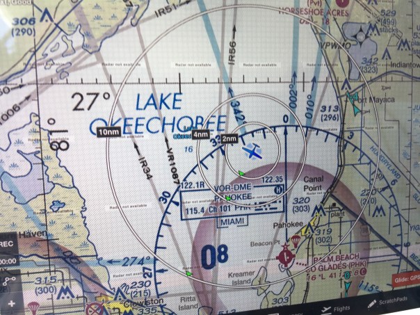


 Entrance to Caloosahatchee on west side of lake and near Clewiston Bloom is all through lake.