This photo of a panther in Sebring was recently shared by a friend. I do hope this magnificent creature has visited western Martin County. Since late October, it has certainly made the rounds. Males roam hundreds of miles, a female less, but easily could cover ground between almost neighboring Martin and Highlands counties.
Can you imagine trying to navigate today’s world? Freeways, subdivisions, fences, shopping malls, the great forests gone…Canals cutting the lands and watersheds apart?
Over 34 panthers were killed on Florida highways in 2016, and at least 23 in 2017. With an estimated 230 in the total population, those are terrible numbers. We must work harder to complete wildlife corridors across the state to allow these animals to breed and travel into north Florida and Georgia. Being stuck in South Florida is a radio-collared death wish.
If this panther does visit Martin County, we’ll probably never know it; though large they are smart to be very, very, shy.
I must say, lately I’ve been hearing rumors of panthers (yes, a pair) in Martin County near Highway 96 out by South Fork, but no photos yet…
Thank God there is something left to run wild in the world; 😊 it gives me something to dream about.
Growing up in Stuart in the 1970s, my mother and father gave me full reign to explore the undeveloped lands in the area of St Lucie Estates. I remember endless summers, wandering around in “the woods” and of course my eyes were drawn to the vine of the widely dispersed, perfectly shaped, red and black seeds known as rosary peas.
I would collect them tightly in my little, sweaty hands, pushing them far down into my pockets. I recall the first time I brought them home, my mother said, “Yes, they are very pretty, but don’t eat them, they are poisonous.”
“Hmmm,”I thought. “How can something beautiful be poisonous?”
I continued to collect the seeds, and over the years filled up many clear glass bottles that sat in my window sill; the sun never fading their brilliant color.
Later in life, I learned that bright color patterns, especially red, black, and yellow, as with some caterpillars, or the famous, shy, and deadly coral snake, are “warnings” in nature and actually provide the animal with protection from being eaten.
As I walk through Hawk’s Bluff today, I am thankful to my parents who allowed me to explore the natural world and grow confident, unafraid, even with all of its toxic beauty.
As the year 2017 comes to a close, we had a special guest sighted in our offshore waters. On December 17th, a Humpback whale was seen breaching in the Atlantic off of Stuart!
Although these mammoth creatures do migrate, and thus navigate our seas, this is a special and rare site.
Perhaps this is time for reflection…
Just as with the Biblical story of Jonah and the Whale, the Native People also give whale sightings and experiences special significance.
According to native lore, “whales visitors/spirits were used to convey a message of power and might, representing the need for strong, silent deliberation.”
Native Images, whales
In the story of Jonah, having turned away from responsibility, and being thrown as “bad luck” from a ship, Jonah is swallowed by a giant whale, reflects, repents, is renewed, is given a second chance, is ejected, and fulfills his responsibilities….
Perhaps there is a lighter message from our visiting whale, like “Happy Holidays,” and “Merry Christmas,” or a fun breach-splash saying “Yahoo! Keep up the fight for clean water!”
For me, the whale visitation made me reminisce on Ed and my visit to Baja, in 2013, to visit the Grey Whales once slaughtered, and now a great tourist attraction, and how this experience of seeing these huge mammals adapt to our human world, especially the mothers with their calves,–the controversy, and alteration in both human and whale actions—– changed my life, and my outlook forever.
In any case, the season is upon us and I am grateful for all of the work done this year for our waters and for our Florida. Thank you River Warriors! Thank you Bullsugar! Thank you Captains for Clean Water! Thank you people of Florida! Thank you President Negron! Thank you all, so many others across our great state! And in closing, thank you visiting whale!
Sometimes it is hard to stay motivated, but like Winston Churchill said: “Never Give Up.” Our work is so important!
…Yes, in 2018, in spite of the difficulties, we will continue to be the strong, silent or screaming giant that dominates the conscience of Florida…
Video credit:
Mattanza Charters, based in Pirates Cove Resort and Marina in Port Salerno, posted video taken Sunday, Dec. 17, 2017, of humpback whales breaching near Eight Mile Reef in the Atlantic. VIDEO PROVIDED BY CAPT. MIKE MURRAY Wochit
The spiral is a pattern in Nature seen in many things…amazing!
As many people along Florida’s east coast, last Tuesday, I was completely prepared for record-breaking, Category 5 Hurricane Irma, to take my house away. She didn’t, but she did others, and the stress for citizens across our state, powerless, stuck in traffic, flooded, schedules off, schools closed, not able to work and create income, with downed vegetation strewn everywhere, is tremendous. It has been widely reported that at one point two-thirds of the state was without power; Irma’s evacuation could be the largest in United State’s history.
Yesterday, after a week in “hurricaneville,” I decided to drive north to the beach to clear my head, calm my nerves, and regroup, as I have many times in my fifty-three years here in Martin County. The beach was full of people, people I did not know. Children ran in the waves shrieking with joy as their exhausted parents held each other silently. As I walked by each family, couple, or person, I wondered what they had been through the past week. And here, we had all come to the edge of the sea, where just days ago nature’s wrath raged taking away the expensive restored beach sands, taking away the control we fight so hard to hold on to.
I walked…
Just north of Jensen Beach, it was like old times when I myself was a kid. Shells were everywhere! A blanket of coquina underneath my feet. I picked up a large, perfect lightning whelk marveling at its beauty. “Look at that spiral…” I thought to myself. ” How peculiar, It looks just like the eye and bands of the hurricane…” a pattern in Nature, I had forgotten about.
For a few minutes, I was transported. I collected many shells, choosing the most beautiful with the best spirals. It got me thinking about words Ernie Lyons wrote years ago, about how we become like moles living underground and forget what a miraculous world it really is…even when the stresses of the world are great.
“What a Wonderful World”
I get an indescribable “lift” from the habit of appreciating life.
All of us, even the most harried, have moments when we are fleetingly aware of the glory that surrounds us. Like moles that occasionally break throughout their tunnels, we infrequently catch a glimpse of the natural beauty and awesome majesty outside the corridor within which we have bound ourselves.
And pop back into our holes!
The habit of appreciation—–the cultivation of the sense of awareness—are forgotten roads to enrichment of personal experience. Not money in the bank, or real estate, or houses, or the exercise of power are true riches. By the true tally, the only value is “how much do you enjoy life?”
All around each of us are the wonders of creation—the shining sun, a living star bathing us with the magic mystery of light…we look to the heavens at night and wonder at the glittering panoply of suns so distant and so strange, while accepting as commonplace our own.
We live in a world of indescribable wonder. Words cannot tell why beauty is beautiful, our senses must perceive what makes it so.
What we call art, literature, genuine poetry, and true religion are the products of awareness, seeing and feeling the magic which lies beyond the mole-tunnel view.
One man, in his mole-tunnel, says he is inconsequential, a slave to his job, of dust and to dust going. Another, poking his head our into the light, realizes that he is a miraculous as any engine, with eyes to see, a mind which to think, a spirit whose wings know no limitations.
The mole-man is bound to a commonplace earth and a commonplace life. He lives among God’s wonders without ever seeing them. But those who make a habit of appreciation find wonder in every moment, and every day, by the sense of participation in a miracle.
They see the glory of the flowers, the shapes and colors of trees and grass, the grace of tigers and serpents, the stories of selfishness or selflessness that are written on the faces men and women. They feel the wind upon their faces and the immeasurable majesty of distances in sky and sea.
And in those things there is the only true value. This a wonderful world. Take time to see it. You’re cheat yourself unless you appreciate it.—–E.L., 1957.
Ernest F. Lyons, famed St Lucie River conservationist, award-winning writer, and long time editor of the Stuart News: (http://www.flpress.com/node/63)
Transcribed by historian, Sandra Henderson Thurlow
“Eden,” the name says it all. Wouldn’t it be cool to say you lived in Eden?
Today there is a historic sign, but there is no longer a town. In 1879 “Eden” was named by Captain Thomas E. Richards who decided this spot along the high ridge of the Indian River would be a good place to grow pineapples. According to historian, Sandra Henderson Thurlow, “Richards felt he had arrived in a tropical paradise, and named his new home Eden.”
In Sandra’s book, “Historic Jensen and Eden on Florida’s Indian River,” she talks about how today’s Jensen Beach evolved from both the historic communities of Eden and Jensen, but over time, while Jensen had room to grow, Eden faded, as it was hemmed in by the wet, fragile ecosystem of the savannas. This marshy savannas system once stretched along the lagoon for over a hundred miles, but today, the only remnant lies right behind the lost town of Eden, and to the north and south of close-by extending lands.
This very special photo was given to my mother, historical Sandra Henderson Thurlow, by Capt. Thomas Richards’s great-granddaughter, Mary Simon.The town of Eden was located between the IRL and the wet savannas, Ruhnke/Thurlow Collection. “Historic Eden and Jensen on Florida’s Indian River,” by Sandra Henderson Thurlow.
These rare lands known today as Savannas Preserve State Park, “encompass more than 5,400 acres and stretch more the ten miles from Jensen Beach to Ft Pierce containing the largest, most ecologically intact stretch of freshwater marsh in southeast Florida.” Remarkable!
If you haven’t ever seen it, I can promise, “Eden awaits you…”
This past weekend, my husband Ed and I put on our wet weather gear, and walked from Jensen Beach Blvd to “west of Eden. ” It is amazing to have this treasure right in our own backyards, a study in plant and animal life that “used to be.” ~A study in what we can bring back, if we want to…
Today, May 12th, at 9:45 A.M. Governor Rick Scott is scheduled to sign Senate President Joe Negron’s “Senate Bill 10” in of all places Clewiston. Clewiston is “America’s Sweetest Town” and the headquarters of U.S. Sugar Corporation…
According to the article in the Glades County Democrat announcing the signing: “Earlier this week Senate Bill 10, a move to secure funding for a water storage reservoir south of Lake Okeechobee was approved. In its amended form, Senate Bill 10 became a measure that we in the Glades could stand behind. The bill no longer stated that additional farmlands be taken out of production but rather the state would utilize the property that it already owns to create a reservoir with a much smaller footprint.”
Although I am scratching my head, you know what? Sometimes you just have to be happy for what you get, no matter where you get it. I am tremendously thankful to Governor Scott for signing the bill ~ although I do wish he had decided to sign it in Martin County since we’ve worked so hard to get it.
When I read the announcement officially last night, it got me thinking about Clewiston before I went to sleep. It brought back memories of 2013 and famed paddle boarder Justin Riney’s idea to hold the Sugarland Rally in Clewiston on September 1st, 2013 to unite the movement. This was one of the early rallies for the river during the devastation of the “Lost Summer.”
Since Governor Scott is going to sign in Clewiston I think it’s a good time to walk down memory lane and be proud of how far we’ve come and to get ready for how far we have to go! The point of the location of the Sugarland Rally was to “meet halfway.” Hopefully Governor Scott is thinking the same, in that Joe Negron helped us meet half way and we are all thankful.
Now let’s remember the past, enjoy today, and then take it to the finish line!
“The Sugarland Rally will unite the east and west coasts of Florida in a peaceful, historic demonstration to speak out against the pollution of our estuaries from Lake Okeechobee discharges. We support both immediate and long-term solutions, but ecosystems and communities along the St. Lucie and Caloosahatchee Estuaries are in crisis. We cannot afford to wait for ecological and economic collapse. We urge all stakeholders–especially local, state and federal governments–to act immediately. We chose Clewiston as a central location to unify east and west at Lake Okeechobee, the source that is polluting our estuaries, and because we believe Florida’s sugar industry can be part of the solution. Please don’t misinterpret our intentions–we are NOT holding a rally at Clewiston to protest or point fingers at “Big Sugar.” It’s quite the opposite, actually. We invite Florida’s powerful sugar industry to join us in crafting an immediate solution to the ecological and economic crisis caused by discharges from Lake Okeechobee.” (Press release from Justin Riney, Aug. 2013)
SUGARLAND RALLY 2013
Maggy Hurchalla, Comm. Taylor, and Mayor RolandDon Voss!Nic Mader, Jenny Flaugh and the River KidzEve Samples of TC Palm and Don Voss with crowd
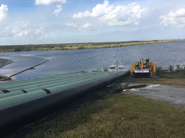
5-7-17: Hutchinson Island along the Atlantic Ocean and confluence of the St Lucie River/Indian River Lagoon, blue waters, seagrass not yet revived from 2013 and 2016 Lake O discharges. Photo Ed LippischMy husband’s flight yesterday over the Atlantic Ocean, St Lucie Inlet, and St Lucie River/Indian River Lagoon is beautiful. But look carefully and you will see a light-colored brownish plume at the mouth of the St Luice Inlet entering the ocean. Finally after months of drought, it has begun raining. And when it rains… (mind you C-44 connecting the St Lucie River to Lake Okeechobee is closed now) the re-directed run-off of waters from canals C-23, and C-24 of course still flow into our St Luice River/Indian River Lagoon.
These canals organized and built during the 1950s and 60s are part of the Central and South Florida Flood Project that the Army Corp built following the hurricane and extensive south Florida flooding of 1949. The run-off waters from these canals and the local watershed are what you see in today’s video.
As damaging as C-23 and C-24 are (they too must be reworked and redirected) they are not the damaging discharges from Lake Okeechobee that throw the St Lucie over the brink as in 2013 and especially 2016 when toxic algae covered extensive portions of the entire St Lucie.
Rio, St Lucie River, Jeff Tucker, toxic algae
…
…
3
Shoreline of Sewall’s Point, Tracy Barnes 6-25-16
…
(Photo mosaic from 2016 shows various photos by Dr Scott Kuhns, Rebecca Fatzinger, (wildlife) JTL/Ed Lippisch, pilot Dave Stone and others.)
In spite of the light brown plume, the short video flight from Jensen to Peck’s Lake shows blue waters near the inlet and mouth of the estuary as it should be, not black water. If Governor Scott does not veto the budget, the reservoir in years to come will help offset the Lake Okeechobee destruction and open the way to truly “send the water south.” #ThankyouJoeNegron
This is very exciting, but believe me, this is no time to let down your guard, as the fight for control of Florida’s waters has really just begun.
Reef system off Sailfish point is covered in black water, sediment, and nutrient pollution when Lake O is discharging. Here after months of drought, and finally some rains we can see the reefs. 5-7-17, Photo Ed LippischMap SFWMD showing canals and basins. Note S-308 or structure s-308 at Lake O and S-80 down the C-44 canal AKA the St Lucie Canal. Both of these structures have to open to allow water to flow into the C-44 canal to the St Lucie River, Indian River Lagoon. All canals are destructive to the St Lucie/IRL yet it is C-44’s Lake O that puts the St Lucie system in complete and total overload.DEP C-23:http://www.dep.state.fl.us/southeast/ecosum/ecosums/c23.pdf
Senate Bill 10, the bill associated with Senate President Joe Negron and his goal to stop the damaging discharges of Lake Okeechobee to the St Lucie River and Caloosahatchee… my gosh, up and then down, and then up again…Why such a roller coaster ride?
The last time I went on a roller coaster ride was many years ago when I in my twenties and teaching German at Pensacola High School. I took my IB high school students and 14 visiting German exchange students to Six Flags. I got so sick on the ride that I had to sit on a bench the remainder of the day. The students? They loved it and went multiple times! Roller coasters are not fun for everyone. But one thing’s for sure, if you’re on the ride, and you feel sick, be assured that it will end, but when it hasn’t, hold on! This bill, this ride, won’t end for another month plus, as it has to be voted on by the full Senate and achieve a matching bill in the House….
Thus far, the bill has really gone “double-full-circle-upside down-roller-coaster” in that Stuart’s Dr Gary Goforth ( http://garygoforth.net) mentioned the many configurations available to achieve “the goal” during the January 11th 2017 meeting of the Senate Natural Resources Appropriations Committee. At this time he pointed out that some of those “loopy configurations” on his visual went back to CERP’s birth year of 2000 and the first goals the state and federal government had for an EAA reservoir!
You can watch Dr Goforth’s presentation and see his handout linked at the top of this post. Gosh, I kind of feel sick, yes, there have been so many changes and so many numbers… 60,000, 14,000, 360,000, 240,000, A-1, A-2, my head is spinning! There is so much back and forth! Yes there is, but goodness, you can’t say this isn’t exciting! The St Lucie River and Indian River Lagoon a roller coaster for the whole world to see! Personally, I am going to try NOT to sit out on the bench this time, how about you? 🙂
Here is a Senate staff summary of what part of the rollercoaster ride the bill is on today:
CS/SB 10:
Establishes options for providing additional water storage south of Lake Okeechobee, including the:
o Everglades Agricultural Area (EAA) reservoir project with the goal of providing a minimum of 240,000 acre-feet of water storage; and
o C-51 reservoir project with the goal of providing approximately 60,000 acre-feet of water storage.
Authorizes the Board of Trustees of the Internal Improvement Trust Fund (TIITF) and the South Florida Water Management District (SFWMD) to negotiate the amendment or termination of leases on lands within the EAA for exchange or use for the EAA reservoir project.
Requires lease agreements relating to land in the EAA leased to the Prison Rehabilitative Industries and Diversified Enterprises, Inc., (PRIDE Enterprises) for an agricultural work program to be terminated in accordance with the lease terms.
Requires the SFWMD, upon the effective date of the act, to identify the lessees of the approximately 3,200 acres of land owned by the state or the district west of the A-2 parcel and east of the Miami Canal and the private property owners of the approximately 500 acres of land surrounded by such lands;
Requires the SFWMD, by July 31, 2017, to contact the lessors and landowners of such lands to express the SFWMD’s interest in acquiring the land through the purchase or exchange of lands or by the amendment or termination of lease agreements.
Requires the SFWMD to jointly develop a post-authorization change report with the United States Army Corps of Engineers (USACE) for the Central Everglades Planning Project (CEPP) to revise the project component located on the A-2 parcel for implementation of the EAA reservoir project.
Requires that if, for any reason, the post-authorization change report does not receive Congressional approval by October 1, 2018, unless the district has been granted an extension by the Legislature, the SFWMD begin the planning study for the EAA reservoir project by October 31, 2018, and proceed with the A-2 parcel project component of CEPP in accordance with the project implementation report.
Requires the SFWMD to give preference to the hiring of former agricultural workers primarily employed during 36 of the past 60 months in the EAA, consistent with their qualifications and abilities, for the construction and operation of the EAA reservoir project.
Establishes the Everglades Restoration Agricultural Community Employment Training Program within the Department of Economic Opportunity to provide grants for employment programs that seek to match persons who complete such training programs to nonagricultural employment opportunities in areas of high agricultural employment, and to provide other training, educational, and information services necessary to stimulate the creation of jobs in the areas of agricultural unemployment. The program is required to include opportunities to obtain the qualifications and skills necessary for jobs related to federal and state restoration projects, the Airglades Airport in Hendry County, or an inland port in Palm Beach County.
Establishes a revolving loan fund to provide funding assistance to local governments and water supply entities for the development and construction of water storage facilities.
Revises the uses of the Water Protection and Sustainability Program Trust Fund to include the water storage facility revolving loan program.
Prohibits, beginning July 1, 2017, the use of inmates for correctional work programs in the agricultural industry in the EAA or in any area experiencing high unemployment rates in the agricultural sector.
Beginning in Fiscal Year 2018-2019, appropriates the sum of $100 million from the Land Acquisition Trust Fund (LATF) to the Everglades Trust Fund for the purpose of implementing the water storage reservoir projects, with the remainder of such funds in any fiscal year to be made available for Everglades projects.
The bill provides the following appropriations for the 2017-2018 fiscal year:
The sum of $30 million in nonrecurring funds from the LATF is appropriated to the Everglades Trust Fund for the purposes of acquiring land or negotiating leases pursuant to s. 373.4598(4), F.S., or for any cost related to the planning or construction of the EAA reservoir project.
The sum of $3 million in nonrecurring funds from the LATF to the Everglades Trust Fund for the purposes of developing the post-authorization change report pursuant to s. 373.4598, and the sum of $1 million in nonrecurring funds from the LATF to the Everglades Trust Fund for the purposes of negotiating Phase II of the C-51 reservoir project pursuant to s. 373.4598, F.S.
The sum of $30 million in nonrecurring funds from the LATF to the Water Resource Protection and Sustainability Program Trust Fund for the purposes of implementing Phase I of the C-51 reservoir project as a water storage facility in accordance with ss. 373.4598 and 373.475, F.S.
“Multiple combinations of location, configuration, land area and water depth can achieve the storage and flow objectives of the EAA Storage Reservoir.” Dr Gary Goforth
Robert Lord is President and C.E.O. of Martin Health Systems, formally known as Martin Memorial Hospital. “MHS” as it is known for short, is the long time top-employer for Martin County, and a respected and expanding health system. It has been located in Martin County for 75 years. (https://www.martinhealth.org) The origianl institution sits along the shores of the St Lucie River, near downtown Stuart and has grown into both south Stuart and St Lucie County. It is a literal “lifeblood” of our communtiy.
I have known and admired the Lord family since my childhood. Bobby Lord, Robert Lord’s father was a local celebrity in Stuart’s early days as he is a County & Western legend. (https://en.wikipedia.org/wiki/Bobby_Lord )I attended both elementary and middle school, and graduated from Martin County High School in 1982 with Robert’s younger brother, Cabot.
I cannot express how much it meant to me last Thursday to see “Robby” Lord, accomplished attorney, now President and C.E.O. of Martin Health Systems, in his position of leadership and influence, speak in support for Senate President Joe Negron and Senate Bill 10. A bill intended to purchase land south of Lake Okeechobee for a reservoir to begin what must happen to save our river: “clean and send more water south.”
Having known the Lord family all these years, I have followed Rob’s career, especially as my sister, Jenny, is physician recruiter, and has served the hospital loyally for almost 20 years.
So, Bravo Rob Lord! You have created a “hometown game-change,” and as we all know, it is not easy to speak up. There are tremendous pressures to conform and accept things as they are. Over the past few years, outside powers have moved into our area influencing and blurring the lines.
I believe that Rob’s speaking out will clear the blurred lines and change the playing field forever. There is no mistaking it. Lake Okeechobee’s discharges are a health issue and must be stopped. Our state and federal government can ignore this no longer in spite of the influences of power.
2016, 239 sq. miles algae bloom in Lake O at S-308 entrance to C-44 and St Lucie RiverSt Lucie River 2016 toxic algae bloom brought on by Lake O discharges into SLR
Excerpt from speech:
“…Good morning, my name is Rob Lord. I am President and C.E.O of Martin Health System .. I care deeply about the impact of Lake Okeechobee discharges on the estuaries. I grew up on the Indian River Lagoon. My family moved here in 1969. I have fished these water with my father, my grandfather, and my brother and nephews and nieces. No one values this eco-system more than my family. We watched it change. As CEO of Martin Health System this has been a significant challenge for us. This past year blue-green algae came to our community. We needed to post this sign in our emergency room. We treated this very much like we needed to treat the Ebola situation….”
Dr. Steven Parr, Director of Emergency Medicine at Tradition Medical Center noted there are studies occurring now to determine whether the toxins trigger certain diseases such as Alzheimer’s, Parkinson’s, and ALS also known as Lou Gherig’s disease.
Osprey with fish, St Lucie River, courtesy of Todd Thurlow
As much as I romanticize my youth along the St Lucie River/Indian River Lagoon in the 1960s, 70s, and 80s, one thing I did not see were birds of prey. Populations had plummeted here and across our nation. The use of DDT, for mosquito control, especially, had drastically reduced bird populations. I truly do not recall even once seeing an osprey fly over the Indian River Lagoon when I was a kid….Hard to believe, isn’ it?
Today, forty years later, every single time I walk the Ernie Lyons Bridge to Hutchinson Island I see multiple ospreys sitting on light posts and diving like missiles into the shallow waters of the Indian River Lagoon. On the Roosevelt Bridge in Stuart there is a resident osprey I count on seeing each time. He sits on the railing completely unaffected by the stream of civilization passing by. Last week, while driving home from Belle Glade, I saw a bald eagle near the Dupuis Wildlife Management Area. “An eagle!” I exclaimed out loud pulling over my car to watch its unmistakable white head and magnificent wing span glide over the tops of the pine trees. “Amazing…” I thought to myself.
The point is, good things happen. Good things are happening now too, but like the birds of prey we may not see the difference until many years have passed. Have hope. Know your work is making a difference for our river and our environment. Things can change for the better. The osprey and the eagle, they are proof. When you see them, be inspired!
Photo by Greg BraunHarbor Ridge eagles, Scott Kuhns
Today I share the second paper of guest, Geoffrey Norris Ph.D. I recently shared Blue-green algal blooms in the lakes, rivers, and marine waters of south Florida surrounding Lake Okeechobee.
I must admit, I hesitated publishing this second paper, “Sugarcane and Indians,” as I am sure some may interpret it as “politically incorrect.” I apologize to anyone who may, but I decided to print Dr Norris’ paper because the main message is important.
The message is:
“Is Sugar’s use of ripening stalks with “Roundup” feeding toxic algae blooms and why are lands/waters south of Lake Okeechobee “protected” while ours of the northern estuaries are not? “
You will learn something about this in Dr Norris’ paper below, and I thank him for sharing his work.
In closing, I believe we have something important to learn from history and the Native People of North America; I admire them. They are great warriors and respect Nature, the gift of our Creator. And in the case of the Miccosukee, they “never surrendered” and if I have anything to do with it, neither will we.
..”In the 1960s, I lived and worked as a petroleum exploration geologist in Tulsa, Oklahoma. Subsequently, I spent almost 40 years at the University of Toronto in teaching and research in geology…A geologist by training, I have a specialized knowledge of fossil algae, their ecology, morphology, and distribution. I have published hundreds of scientific papers on fossil algae and related topics.” ~Geoffrey Norris Ph.D.
rosalex@interlog.com
Sugarcane and Indians
Executive summary
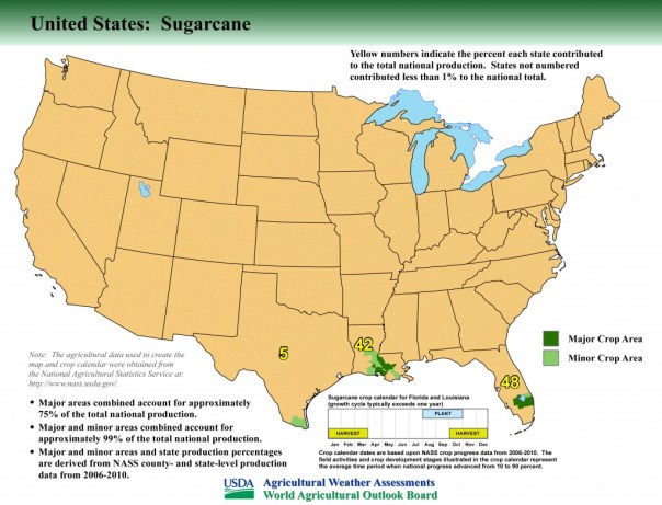
The area around Lake Okeechobee accounts for almost half the total production of sugarcane in the United States.
Sugarcane in south Florida is very needy of phosphorus and potassium fertilizers, but nitrogen fixed in the muck soils largely eliminates the need for extra nitrogen fertilizers.
Sugarcane also demands the use of the phosphorus-rich herbicide “Roundup” (glyphosate) several times each year. Firstly, in the fallow season (approximately May-September) to control weeds and allow the sugarcane underground rhizomes to regenerate. Secondly, as the new shoots come through in the Fall to continue weed control. Thirdly, during maturation and harvesting (October through March) glyphosate is applied to “chemically ripen” the sugarcane and improve sugar yields.
Land south of Lake Okeechobee could be used for storage and bio-cleansing of excess lake water. However, the 1997 water quality agreement between the Environmental Protection Agency and the Miccosukee Indians (aka Mikasuki, Miccosuki) states that phosphorus shall not be present in quantities greater than 10 parts per billion, and that no substance shall be present to stimulate algal growth and produce objectionable algal densities in the 300,000 acres of tribal lands in the Everglades south of Alligator Alley.
This legal agreement would suggest that Lake Okeechobee waters destined for southern storage must be cleaned to rigorous standards before discharge into southward flowing streams feeding the Everglades, at least near the Miccosukee tribal lands.
A case could be made for the sugar industry and related agriculture to “clean up its act” to mitigate the effects of heavy fertilizer and herbicide usage on the environment in general and on lake and stream waters in particular.
Sugarcane and Indians
First about nutrients and farm land and how much is planted in sugarcane.
Here are three maps that graphically answer the question about the extent of sugarcane plantations:
A couple of years ago I had the opportunity the fly over the area south of Lake Okeechobee in a light plane at about 1000ft altitude. The extent of the sugarcane is truly mind-boggling. Its plantations surround the entire southern perimeter of the Lake and reach to the horizon. Smaller plantations occur elsewhere around the Lake. It is a very big operation.
Now to the nutrients themselves. I had a great deal of difficulty finding precise information on how much fertilizer is applied per unit area. There were general articles that confirmed that sugarcane is very needy of nitrogen, phosphorus, and potassium fertilizers together with other elements. It is after all a giant grass, so just think how much stuff you have to put on your own lawn to make it grow green! Apparently, in the south Florida area the need to apply nitrogen fertilizer to sugar cane is not so critical because the mucky soils generate their own nitrates through soil microbial activity. However, phosphates must be applied as fertilizer for sugarcane at various times of the year together with potassium etc. But actual numbers were hard to come by, other than that sugarcane is voracious for fertilizers. This is when I stumbled upon some marvellous work that the U.S. Geological Survey has been doing on the extent and the total quantitates of pesticides being applied to farmland across USA. I used their maps of glyphosate (Roundup) as what I thought might be a reasonable proxy for phosphate fertilizer. In other words, if you use Roundup as a weedkiller on crops, then very likely you will be using fertilizer as well. It turns out I was right and I was wrong! First take a look at this summary map for two separate years, 1992 being the earliest year available in this USGS study:
Details are difficult to see in these summary maps but the originals are much clearer. The area around Lake Okeechobee was already in 1992 applying large amounts of glyphosate, and this intensified in succeeding years. What I didn’t understand was why the sugarcane fields should be so needy of weedkiller – fertilizers OK, but why so much weedkiller? It would seem that 25% of the cost of sugar production is due to heavy nutrient need (up to 75 lbs phosphate per acre, with 400,000 acres in sugarcane in south Florida). But weedkiller. Then I dug deeper following your email comments and found out why. Indeed glyphosate is used at least three ways on sugarcane as follows:
Firstly, during the fallow season (approx. May-September 2016) following harvesting, glyphosate is applied to control weeds which would otherwise grow up and choke out the underground cane sugar rhizomes left in the ground to regenerate as the next crop.
Secondly, glyphosate application continues in different amounts as the new shoots come through in the Fall. This is tricky because glyphosate kills just about anything that is green, but careful control can kill the young weeds while not harming – at least not very much – the young sugarcane shoots. Other herbicides are also involved but glyphosate is the big one.
Thirdly, the sugarcane matures and is harvested in the winter months at various times from October through March. During this time the stem of the sugarcane ripens and becomes rich in sugar (sucrose) prior to going to the mill. Astonishingly (to me anyway) it has been found that about a month or two prior to harvesting, another application of glyphosate will help ripen and enrich the crop with significantly more sugar. This process is called “chemical ripening”. Other chemicals can be involved but glyphosate is a popular choice (it got cheaper once Monsanto’s patent expired in the year 2000).
So yes, I think cane sugar farming is being pursued intensively, but I’m not sure how it can be stopped. Its effects on Lake O could be mitigated as discussed in my previous document but stopping an entire industry would be almost impossible to my mind. Cleaning up the sugar industry might be a more realistic aim.
Change of land usage and water flow.
It would be nice to think that Lake Okeechobee water could be redirected southwards along its original historic course on its way to the Everglades. Here’s a graphic of how things used to be:

For thousands of years, water drained from Lake O through a wide series of shallow tributaries and interconnected lakes to the Everglades. It’s unlikely that this could be recreated but certainly use of land south of the Lake for water transport and storage and bio-cleansing of some sort or another would be an improvement. However, it would seem that this is unlikely given the actions of the U.S. Environmental Protection Agency and its agreement in 1997 re the Clean Water Act with the Miccosukee Indians, a tribe which occupies part of the Everglades.
This agreement set out comprehensively water quality standards for the Tribes drinking water, wildlife habitat water, and recreational water (boating, swimming etc). In particular, Section 3 reads:
MICCOSUKEE ENVIRONMENTAL PROTECTION CODE
SECTION 3. Tribal Water Quality Standards
The following minimum water quality criteria shall apply to all surface waters of the Miccosukee Tribe of Indians of Florida unless those water bodies are designated with higher or stricter water quality standards. Stricter standards for a given water body shall supersede these general Water Quality Standards. These standards shall provide a legal basis for including whole effluent toxicity requirements in all federally issued permits.
(there follows a list of 16 physical, biological, and toxicological conditions of which these two are particularly germane):
E. NUISANCE CONDITIONS: Plant nutrients or other substances stimulating algal growth, from other than natural causes, shall not be present in concentrations that produce objectionable algal densities or nuisance aquatic vegetation, or that result in a dominance of nuisance species instream, or that cause nuisance conditions in any other fashion. Phosphorus and nitrogen concentrations shall not be permitted to reach levels which result in man-induced eutrophication problems. Total phosphorus shall not exceed 10 parts per billion in Class III-A waters. In Class III-B waters, total phosphorous discharges shall not be made which result in undesirable aquatic life effects or which result in chronic or acute toxicity to aquatic life.
N. NUTRIENTS: In no case shall nutrient concentrations of Tribal Class I or Class III-A surface waters be altered so as to cause an imbalance in natural populations of aquatic flora or fauna. Total phosphorus concentrations shall not exceed 10 parts per billion in Class III-A waters. In Class III-B waters, nutrients shall not be discharged which result in undesirable aquatic life effects or which result in chronic or acute toxicity to aquatic life.
So what this and other sections of agreement mean is that nutrient-rich water from Lake Okeechobee must be cleaned to rigorous standards before discharge into southward flowing streams feeding the Everglades. So bio-cleansing within the Everglades – or at least near the Miccosukee tribal lands (about 300,000 acres in the vicinity of the Tamiami Trail and Alligator Alley) is not a possibility within this legal framework.

However what’s good for the goose is surely good for the gander. I looked into the history of the Miccosukee Indians, and it would seem they are only fairly recent arrivals in Florida, arriving about the same time as Stuart was being settled. The Miccosukee appear to have originated in what is now Georgia and then migrated south to north Florida where they became entwined with the Seminoles. After the Seminole wars of the 19th century they migrated to central Florida in the late 1800’s and then decided to disentwine themselves from the Seminoles as a culturally distinct society. They appear to have seen an opportunity during the construction of the Tamiami Trail in the first quarter of the 20th century and migrated further south and became embedded in the adjacent Everglades. First Florida (1957) then federally (1962) they became recognized as a tribe distinct from the Seminoles.
Meanwhile in th early 20th century, as the migrant Miccosuki Indians were settling down in their new home in the Everglades as “Trail Indians”, Stuart was incorporated as a town (1914) then a city (1925) after being settled by migrant northerners about half a century earlier. Total population of Stuart is now about 16,000.
640 migrant Indians – how many are fishing and frogging? 16,000 migrant non-Indian northerners – how many lives and livings are being disrupted by ruined beaches and waterfronts?
the Indians pushed for a great deal from EPA and got it. So now a total of about 640 Miccosukee (Mikasuki) Indians (some now living in Miami-Dade and not the Everglades) can pursue their supposedly traditional way of life (fishing, frogging, subsistence agriculture) plus gaming resorts and casinos and tobacco shops – while many of the 151,000 citizens of Martin County are prevented from pursuing their traditional way of life. Surely our waters (habitat, recreational, drinking) should be subject to the same rigorous standards as laid down by the EPA/Clean Water Act for the people living in the Everglades.
We are all equal – as George Orwell said – but some are more equal than others. Well, so it seems. What do you think?
_________________________________________________________
Writing my blog allows me to meet many interesting people. Recently, fellow Sewall’s Point resident, and active Vietnam Veterans of America member, Mr. Frank Tidikus, introduced me to Canadian and part-time Martin County resident, Professor Geoffrey Norris who is a geologist and algae fossil specialist with a long career at the University of Toronto.
Professor Norris, his wife, and I met at the Prawnbroker and had a lovely exchange. Dr Norris describes himself as such…
...In the 1960s, I lived and worked as a petroleum exploration geologist in Tulsa, Oklahoma. Subsequently, I spent almost 40 years at the University of Toronto in teaching and research in geology…A geologist by training, I have a specialized knowledge of fossil algae, their ecology, morphology, and distribution. I have published hundreds of scientific papers on fossil algae and related topics…
Professor Norris shared two papers composed for his property association at Indian River Plantation on Hutchinson Island along the Indian River Lagoon during the 2016 toxic algae extravaganza. Today, I will share the first entitled: “Blue-green algal blooms in the lakes, rivers, and marine waters of south Florida surrounding Lake Okeechobee.” His second, specifically on Sugarcane, I will provide next week.
Professor Norris’ summary and full paper is below. It is excellent in that it is able to relay complex subjects to the everyday reader interested in water quality and improving the plight of our St Lucie River/Indian River Lagoon.
What is most amazing to me are his comments on glyphosate, most famous for being the active ingredient in Roundup, but now used under many names. Sometimes I hear people screaming so much about Roundup that I tune it out, but Professor Norris’ observations really got to me.
He notes that glyphosate, used excessively in agriculture production around south and central Florida may actually “feed”cyanobacteria (toxic blue-green algae blooms). Also mind-blowing are Professor Norris’ insights into the reproduction of the hungry and ancient cyanobacteria that reproduces through binary fission (copying itself) “producing endless clones” “with no dissipation of mutant genes as a checks and balance to adaptation…”
Yikes! Really?
Blue-green algae mat St Lucie River July 2016, Snug Harbor, JTLWell, enjoy the reading the paper. And know, together we are making a difference!
Jacqui
Public maps info shared by Dr Norris, courtesy of USGABlue-green algal blooms in the lakes, rivers, and marine waters of south Florida surrounding Lake Okeechobee
Executive Summary
This report provides basic information on blue-green “algae” and explains that they are actually bacteria (cyanobacteria). These blue-green bacteria form blooms in Lake Okeechobee that in turn are released by the Army Corps of Engineers into canals and estuaries of south Florida.
The blue-green bacteria grow by using sunlight as an energy source to synthesize elements from the water into more complex compounds used in their cells. When important nutrients such as phosphorus and nitrogen are present in excess, the bacteria multiply rapidly and accumulate as highly concentrated masses of cells, called blooms.
Blue-green bacteria can synthesize nitrates from atmospheric nitrogen, but also need phosphorus dissolved in water to survive and thrive. If phosphorus is scarce in the water, this limits the growth of the bacteria. If it is abundant, blooms can be triggered.
Run-off and back pumping into Lake Okeechobee from surrounding Everglades agricultural lands and upstream from the Kissimmee River watershed is suspected of providing a potential abundant source of phosphorus for blue-green bacteria, in phosphate-rich fertilizers and herbicides such as Roundup (glyphosate).
Glyphosate (2-[(phosphonomethyl)amino]acetic acid) is of particular concern, since it has been used heavily in the agricultural areas around Lake Okeechobee and upstream in the Kissimmee River watershed for at least 25 years. Glyphosate provides a source of phosphorus for blue-green bacteria and recent research by others suggest that glyphosate enhances the growth of blue-green bacteria, which become tolerant and absorb glyphosate directly.
The blue-green bacterial blooms released into the St Lucie Estuary (principally Microcystis) are formed in freshwater but appear to be tolerant of dilute salinities, and recent research suggests can build up resistance to increased salinities such as are found in estuarine waters.
Blue-green algal blooms in the lakes, rivers, and marine waters of south Florida surrounding Lake Okeechobee
I am a property owner in Stuart, Florida and have been alarmed – along with many others – at the spread of blue-green algae (aka cyanobacteria) into the St Lucie River and adjacent areas by water releases from Lake Okeechobee. There has been much publicity and calls for action over the years but very little appears to have been done to solve this long-standing problem at any level of government, until very recently. Now, a State of Emergency has been declared by the Governor of Florida. Recent initiatives, following public meetings in Martin County thanks to the Board of County Commissioners, have been undertaken by Florida Representative Gayle Harrell and Senator Joe Negron and their colleagues in association with Senators Marco Rubio and Bill Nelson and Rep. Patrick Murphy to urge the Army Corps of Engineers to stop immediately the nutrient-laden discharges from Lake Okeechobee.
Although I am a property owner and tax payer in Martin County, I am also a Canadian snowbird and therefore do not have a vote, which is a little constraining when trying to influence political decisions. Therefore, I decided to put my energies into assessing what is known about the current situation of the blue-green blooms. I am a geologist by training and I do have a specialized knowledge in particular of fossil algae that have been extremely important in oil and gas exploration over the decades gone by. I am not a biologist but I do have some knowledge of the literature on algae – their ecology, morphology and distribution in various environments. I have published hundreds of scientific papers on fossil algae and related topics and hope that the following – largely based on biological and agricultural literature – will pass muster.
In the following presentation my aims are twofold:
Firstly, to try and answer commonly asked questions about blue green algae (which are actually bacteria) that might be helpful in clarifying some of the technicalities of a complex subject.
Secondly, to highlight what to my mind is the ultimate cause of the blue-green outbreak: that is, the heavy application of phosphate-bearing fertilizers and herbicides around Lake Okeechobee together with back pumping of agricultural run-off into the Lake. In particular I believe that the well-known weed killer glyphosate (e.g. Roundup) may be implicated as a major contributor to the problem. South Florida and somewhat later Central Florida became major users of Roundup in the early 1990s, long before its popularity spread north into the corn and bean belt.
Feel free to pass this article on to others. I would welcome comments by email at rosalex@interlog.com
What are blue-green algae?
Well, for starters they are not actually algae at all. They were discovered in the 19th century by biologists using newly invented high-powered microscopes. They noticed a variety of microorganisms living in water, some of them with green pigments in the cells that allowed photosynthesis to occur, similar to the well-known photosynthesis occurring in the much larger land plants and driven by chlorophyll. But they were much simpler in organization than the large land plants so were called “algae” (singular alga, from the Latin word for seaweed). Some of these microorganisms contain a rather different bluish pigment and were therefore referred to as “blue-green”, and in these early days were judged nevertheless to be algae – hence blue-green algae.
It was only later that biologists realized that the blue-green microorganisms were crucially different from algae because they had no nucleus in the cell and their pigment was not organized into a “blob” within the cell like most other algae. In the scientific literature they are now regarded as bacteria and the blue-greens are referred to as cyanobacteria – that is, photosynthetic bacteria that use a blue-green pigment to facilitate the use of the sun’s energy to produce organic compounds needed by these organisms.
It is important to understand this difference between the blue-green cyanobacteria on the one hand and the “true” algae on the other. I will come back to the difference between bacteria and algae later, and how this impacts on bloom formation.
Meanwhile, the term “blue-green algae” has gained traction in the news media and is now widely understood to be implicated in the blooms of microorganisms that occur from time to time in lakes and rivers in Florida and elsewhere. I will use either of the terms “blue-green algae” or “cyanobacteria” depending on the context, or just the neutral term “blue-greens”. But remember they are actually bacteria.
What are algal blooms?
An algal bloom is the result of rapid increase or accumulation of algae in a body of water. They can occur in freshwater (lakes, rivers) or in marine water (estuaries, lagoons, coastal embayments). Different types of algae (including the blue-green cyanobacteria) produce different blooms characterized by green, bluish, yellow, brown or red colors. The density of pigmented cells in a bloom is enormous, and measured in the hundreds of thousands to billions of cells per liter (1 liter is almost a quart) depending on the species.
Blooms can be quite localized and appear as a streak on the water or can be very large and visible from space, such as the algal blooms that occur from time to time in Lake Erie and measure tens to hundreds of miles in extent. The recent blue-green algal bloom in Lake Okeechobee was reported to be more than 30 square miles in extent.
What causes blooms?
Blooms occur naturally when the water contains an excess of nutrients such as phosphorus and other compounds. This causes an increase in the growth of algae leading to very high concentrations of cells that become visible as colored streaks and patches in the water. Other factors involved in triggering algal blooms include temperature changes, sunlight intensity, changes in water chemistry and changes in water currents.
What are the red tides that occur in Florida?
A red tide is just another name for a bloom of “true” algae in marine water, and in this case a particular algal group called dinoflagellates. Red tides can be red but more often occur as greenish or yellowish colored water in the coastal areas of Florida. The term “harmful algal bloom” is often preferred in referring to these dinoflagellate blooms that do indeed harm wildlife and human life in different ways e.g. toxic shellfish poisoning; respiratory illness; mass fish kills.
So what caused the blue-green algal blooms in Lake Okeechobee?
First, it is important to understand that blue green algae are uniquely different. Not only are they photosynthetic bacteria but they are also capable of manufacturing their own supply of nitrates from nitrogen in the atmosphere, one of their crucial nutritional requirements. So the blue-greens have plenty of nitrogen to live on but they also need other important elements and compounds to thrive. One of these is phosphorus, which often occurs naturally in water in trace amounts as phosphates. If phosphorus is scarce, then this limits the growth of the blue-greens even though they have potentially a lot of nitrates available. The amount of phosphorus available becomes a limiting factor for growth of the blue-green algae. If phosphorus becomes more abundant in the water, then the blue-green algae thrive and multiply until they become visible as a bloom. It is believed that high phosphorus concentrations in Lake Okeechobee are capable of triggering blue-green algal blooms.
So where did the phosphorus come from in Lake Okeechobee?
Lake Okeechobee is surrounded by agricultural land that is being intensively farmed. Run-off from the farmland appears to be entering Lake Okeechobee, and this includes various phosphate-rich fertilizers and herbicides such as Roundup (glyphosate).
But Lake Okeechobee water levels are higher than the surrounding plain. How can run-off into the Lake happen?
Well, firstly, Lake Okeechobee and the surrounding farmland share a common water table. Transfer of minerals and soluble organic compounds can occur through the groundwater. But probably more importantly, until recently it was common farming practice to back pump excess run-off water from the agricultural land into Lake Okeechobee. Almost certainly this had led to the accumulation of phosphorus and other nutrients in the Lake as well as unused agricultural chemicals. Aerial transmission into the Lake from crop dusting is also possible.
So now that back pumping has been discontinued will this solve the problem?
Not really, because although farmers now are not allowed to back pump into the Lake, the South Florida Water Management District has responsibility to alleviate the threat of flooding. They can – and do – back pump surface water from the surrounding land into Lake Okeechobee, if excessive rainfall conditions threaten to flood the communities around the Lake. Rainwater running off the agricultural land will still contain phosphorus and other compounds derived from fertilizers. Furthermore, from time to time the Army Corps of Engineers controls the level of Lake Okeechobee by releases of lake water into the canals, which in turn feed into the estuaries around Stuart and other coastal communities.
Are there any other agricultural products that are contributing to the appearance of blue-green algal blooms?
Yes, there is one in particular that is of great concern. Glyphosate is the active ingredient in the well-known weed killer Roundup. It is used intensively by farmers over much of North America. South Florida is one of the areas where it is being used very heavily in agriculture, and has been since at least 1992 (the earliest available data). A little further to the north, Central Florida’s usage of glyphosate surged in 1993 and continued until 2013 (the last available data) and may also be a source of glyphosate in Lake Okeechobee but originating further upstream in the Kissimmee River watershed and its interconnected lakes.
Glyphosate is an organic compound with phosphorus as an important component as well as nitrogen in its chemical make-up. It was invented by Monsanto chemists, brought to market in 1974, and its chemical name is N-(phosphonomethyl)glycine (aka 2-[(phosphonomethyl)amino]acetic acid) – glyphosate for short and much more easily remembered. Monsanto’s patent on glyphosate expired in 2000 and since then it has been manufactured by dozens of companies with a significant drop in price and therefore increasing popularity with farmers. In 2007 it became the most-used herbicide in agriculture in USA. It works as a weed killer by inhibiting the production of certain plant amino acids and enzymes. After it has done its deadly work, some of it can break down in the soil into simpler molecules of carbon, hydrogen, oxygen, nitrogen and phosphorus. Excess glyphosate can run off into water, particularly at peak farming times. Its use has been expanding in the agricultural sector by about 20% per year for the last several years.
So far, so good. It kills most green plants, if that is what you want. I personally use it to kill poison ivy on my property. Unfortunately, it has become apparent through a number of recent laboratory-based studies that glyphosate does not act as a killer for some blue-green algae, aka cyanobacteria. Firstly, the blue-greens love the phosphorus in glyphosate or its degradation products, which otherwise is a limiting factor in their survival. They thrive on increased phosphorus. Secondly and more insidiously, recent research has indicated that glyphosate actually enhances the growth of blue-greens. The blue-greens apparently have the ability to absorb glyphosate directly from the water and some are tolerant to it or become adapted to it by rare genetic mutations.
OK, but rare genetic mutations are just that – rare! So what?
Well, you remember that blue-greens are actually bacteria, not true algae. As such their genetic material is distributed throughout the cell, and they reproduce by binary fission producing endless clones. There is no “mix-and-matching” of chromosomes and genes such as occur in nucleated organisms using sexual reproduction that tends to dissipate the effects of mutant genes. Once a cyanobacterium has undergone a mutation, that mutant gene is replicated again and again as the cell divides. It produces clones of the mutant cell, and if that mutant has an advantage (such as resistance to or affinity for glyphosate), it will rapidly spread.
A more familiar example is the recent rise to prominence of so-called superbugs that are resistant to antibiotics. Human infections are often related to bacteria that enter the body, and are treated by the intake of prescribed antibiotics as a course of treatment for a number of days. If the antibiotics are not taken for an adequate period of time, the residual bacterial population includes mutants that resist the drug in question, and in turn that drug becomes less and less effective against new infections. This way a superbug is created e.g. MRSA (methicillin-resistant Staphylococcus aureus). So think of the blue-greens as bacteria (which they are) and glyphosate as an antibiotic (which it is). Those blue-green cyanobacteria that survive the glyphosate thrive as mutants and have the capacity to spread widely.
Do blue-green blooms last forever?
No. Eventually the blue-green bloom uses up available resources and requires more nutrients than are available leading to a decline in the number of cells in the water column. Also in temperate climates, the onset of winter temperatures can put an end to algal blooming for that season.
Then what happens?
The blue-green cells die off and sink to the bottom of the lake or estuary. Other bacteria move in and use the debris from the dead blue-greens as a source of carbon, and use oxygen in the water to fuel their own growth. This in turn leads to oxygen depletion that can be very severe. Without oxygen in the water, normal aquatic life becomes impossible and a dead zone is created: fish move away, and other organisms die that can’t move into more oxygen-rich environments.
How many blue-green algae/cyanobacteria exist?
About 2500 living species have been described in the literature but probably double or treble that number exist and await discovery and description. They have a very long geological history. Fossilized blue-greens have been discovered in rocks 3.5 billion years old.
How many are harmful?
Only a dozen or so species are actually harmful when they form blue-green blooms and emit toxic substances. In the recent outbreak, Microcystis aeruginosa has been identified as a bloom-forming cyanobacterium together with a couple of others.
So which blue-greens are responsible for the Lake Okeechobee and St Lucie River blooms?
The Florida Dept of Environmental Protection (DEP) took a number of samples from sites in Martin County and adjacent areas from Late May to Late June 2016 and the results are available at their website:
Most samples are reported as “mixed algae; no dominant species in the sample”, but a few are reported with more detail (numbers are depth in meters):
Martin County
St. Lucie River, Central Marine Marina (N 27° 12′ 55″, W -80° 15′ 18″)
0.3
Dominant taxon: Microcystis aeruginosa
Martin County
Dire Point Canal (N 27° 12′ 24.47″, W -80° 16′ 16.90″)
0.3 m
mixed algae; no dominant species in sample though specks of Microcystis aeruginosa present.
Martin County
SE Harbor Pointe Dr. (N 27° 12′ 12.44″, W -80° 12′ 44.77″)
0.3 m
mixed algae; no dominant species in sample though specks of Microcystis aeruginosa present.
Martin County
C-44 and S. Fork Mouth (N 27° 7′ 46.13″, W -80° 15′ 58.02″)
0.3 m
mixed algae; no dominant species in sample though specks of Microcystis aeruginosa present.
Martin County
S-80 (N 27° 06′ 41.87″, W -80° 17′ 06.08″)
0.5 m
Dominant taxon: Planktolyngbya limnetica
Martin County
Lake Okeechobee – Port Mayaca S 308 C Upstream Lake Side
N 26° 59′ 6″
W -80° 37′ 16.5″
Water column
Dominant: Microcystis aeruginosa
Hendry County
Lake Okeechobee near Channel Marker 9B
N 26° 46′ 36.6954″
W -80° 54′ 8.676″
Water column
Co-dominant taxa: Microcystis aeruginosa and Dolichospermum circinalis
Clearly, Microcystis appears to be important in several blooms, but quantitative and qualitative data are not provided for the majority of samples, making further evaluation impossible at this time. Dolichospermum (aka Anabaena) is a well known blue-green that produces nerve toxins and liver-damaging toxins, as does Microcystis. Planktolyngbya limnetica is another well known toxic blue-green.
How adequate has the sampling and analysis program by DEP been?
It is difficult to say for sure, since DEP only provides results of their program, not the sampling and analytical strategies themselves. However, from what can be gleaned from their website it would seem that during the month of June 2016 DEP collected 24 samples from 7 counties (Martin, Palm Beach, St Lucie, Lee, Charlotte, Hendry, Glades) over a 29 day period, covering a transect from the Atlantic coast to the Gulf of Mexico (Stuart/Palm Beach to Fort Myers). Of those 24 samples, 83% were reported “mixed algae; no dominant species in the sample” without further details. I would judge this to be a token response to what is clearly a major emergency. The analytical results appear to be lackluster to judge from details available on the website. No doubt DEP activities are constrained by their budget, but the lack of urgency in attempting to characterize these blooms is disappointing at best and may eventually be judged negligent to some degree.
What is known about Microcystis aeruginosa?
Quite a lot. It is the most common harmful algal bloom-forming species in freshwater. The cells are tiny but colonies can be macroscopic in size and contain gas vesicles that allow the colonies to be buoyant and float to the surface of the lake. It produces both neurotoxins and hepatotoxins that contaminate the water and have been known to kill dogs, other large animals and livestock in general that drink the polluted water. The toxins may be carcinogenic. Microcystis has a drastic effect on dissolved oxygen in the water that can lead to mass fish kills.
Can blue-green algae live in salt water?
This depends on the species. Many truly marine blue-greens are known in seas and oceans where they play an important role in nitrogen fixation and are important components of the marine ecosystem. In the case of Stuart and the St Lucie inlet and estuary, these natural estuarine waters have been diluted and/or replaced by fresher water discharges from Lake Okeechobee as shown in recent Florida Oceanographic Society water quality reports:
In turn this has allowed freshwater blue-greens such as Microcystis to establish colonies and blooms in areas that otherwise would support more saline organisms. So, for example, on June 30th 2016, the north and south forks of the St Lucie River, the St lucie River adjacent to Sewells Point, and the Manatee Pocket were reporting salinity values in the range of zero to 13 parts per thousand, areas which otherwise would be in the range of 15 to 30 parts per thousand. Hence some of these diluted saline waters can now support freshwater blue-greens.
Alarmingly, recent laboratory-based research has shown that some blue-greens – such as Microcystis – can build up resistance to increased salinity and, therefore, if this happens in the natural habitat can expand their range from freshwater to higher salinities.
What can be done to improve the situation?
If you have a vote at any level of government, contact your elected politicians to highlight the urgent nature of the blue-green blooms and to bring pressure to bear to use available resources to solve the matter.
Stop the back pumping of run-off water by anyone into Lake Okeechobee.
Curtail the heavy application of phosphorus-rich agricultural chemicals in farmland surrounding Lake Okeechobee.
In particular, request a thorough scientific investigation into the effects of glyphosate (Roundup) on blue-green algae (cyanobacteria) and their blooms.
In the long run, demand that the dike surrounding Lake Okeechobee be rebuilt with a view to diverting southwards the impounded waters back into the Everglades.
S-80 dumps from Lake O into the SLR, image created by Doc Snook, 2013.Regarding Senate Bill 10, and the recent changes made to the bill~
I thought I would just go on-line and compare the first bill to the second with its amendments…kind of like juxtaposing town ordinances between first and second reading. Well, I learned over the past week, that this is not as easy as I had anticipated. In fact, to interpret well, I think I need a lawyer, or to become one.
Nonetheless, today I have gathered information to help us understand what is/has happened with Senate Bill 10. The essence of its changes is encapsulated in these recent words by Senate President Joe Negron about the bill:
“Harmful discharges from Lake Okeechobee have flooded communities on the St. Lucie and Caloosahatchee Rivers with massive amounts of toxic algae that destroyed estuaries and harmed the local and state economies. Unfortunately, incidences like these are not unique in our state and are a symptom of the lack of attention to water resource development. The lost summer must be a wakeup call for all Floridians.”
Powerful words from a Senate President. And between the lines we see that he is trying to build bridges to garner more support…as the powers that be have been repeatedly clubbing the bill over the head, in form with their outdated ideology.
So the bill has changed, it may be slightly wounded but it is still alive, and the dramatic destruction of our St Lucie/Indian River Lagoon has become the seed of change for our entire state. Wow. This is fitting as Martin County has a history of inspiring change and being a leader when it comes to the environment.
Ernest Lyons, the great “Stuart News” newspaper man, and others are in their graves smiling I am sure. He may even be smoking a cigar.
Nonetheless, we must remain the epicenter of this state-wide change…we must keep foucs.
The toxic destruction from Lake Okeechobee is a not by accident, but a rather a state and federally sponsored decision embedded in a power culture that has ruled for over one-hundred years. It is time to crack this wide open, thus even though the bill is morphing Senate Bill 10 must keep the EAA land purchase and reservoir component.
And although it has grown to include others, it still has this critical component.
Concerns?
The Florida Wildlife Federation states:
“Unfortunately SB10 has been substantially amended to include funding for water supply developments (pipes and pumps)…The bill changes the direction of the state’s major land acquisition programs from conservation purposes, to acquisition and improvements to land and water areas to protect, restore, and DEVELOP, water resources…These amendments are concerning…” I trust FWF’s concerns are warranted and should be looked at.
Now for the fun part! Below you can compare the two bills, it has gone from 14 to 27 pages!
The press releases following help interpret the bill’s intent. Below the Florida Senate links are two reporter’s insights that I feel are quite helpful, Isadora Rangel of TCPalm and Nancy Smith from Sunshine State News.
In closing, we must never give up because we are destined to change the long-standing culture of drainage and destruction for the St Lucie River/ Indian River Lagoon and now for the great state of Florida.
MORE PROJECTS ADDED
Bradley also added projects to garner support from lawmakers across the state. Those include:
• Creating a loan program to help government and private entities pay for water storage projects that prevent it “from being discharged to tide or otherwise lost to protect the waters of the state.” The loan would pay up to 75 percent of the project and give priority to alternative water supply in areas with limited water sources or that are threatened by salt water intrusion.
• $20 million for grants to help local governments convert septic tanks to sewer systems or remove muck in the Indian River Lagoon and the St. Lucie and Caloosahtachee rivers, as Gov. Rick Scott has proposed;
• $35 million per year for the restoration of the St. Johns River and its tributaries or the Keystone Heights Lake Region;
• $2 million annually for septic-to-sewer conversions, stormwater projects, muck removal and other water quality projects in the Florida Keys.
Sunshine State News, Nancy Smith
The Coast-to-Coast Comprehensive Water Resource Program includes the following:
— Acceleration of the timing and funding for the state share of the Everglades Agricultural Area Storage Reservoir Project. The bill authorizes the purchase of land for the project from willing sellers in the EAA and does not authorize the use of eminent domain.
— Funding of the state share of all existing Comprehensive Everglades Restoration Plan (CERP) projects in the integrated delivery schedule (IDS), including the Lake Okeechobee Watershed Project, the C-43 West Basin Storage Reservoir Project, the C-44 Reservoir Project, the Western Everglades Restoration Project, the C-111 South-Dade Project, and the Picayune Strand Restoration Project.
— Direction to the Army Corps of Engineers to begin the reevaluation of the Lake Okeechobee Regulation Schedule to take into account repairs to the dike and new southern storage features to increase storage in the lake as early as possible.
— A new bonding program, building on the Florida Forever model that recognizes the need to bond for water resource protection and development across Florida. The bill transfers the remaining $3.3 billion of existing bonding authority from Florida Forever to the Florida Coast-to Coast Water Resources Initiative. The bill does not create additional bonding capacity.
— A new revolving loan financing program and statutory tools to allow the state, water management districts and local governments, to develop and operate water storage and supply facilities to service regional populations addressing the growing need for water supply in the state.
— Dedicated LATF funding to expand Legacy Florida to include projects addressing water quality and restoration with the St. John’s River and the Florida Keys.
— Funding to aggressively address the retrofitting or conversion to central sewer systems of outdated septic systems consistent with Gov. Rick Scott’s leadership on this issue.
— Provisions that encourage reuse by establishing a water reuse grant program, specifically to assist wastewater treatment facilities to expand capacity to make reclaimed water available for reuse.
A biography of the late Ernest Lyons, Stuart News editor and nationally recognized for his writings in support of the environment and the St Lucie River: http://www.flpress.com/node/63
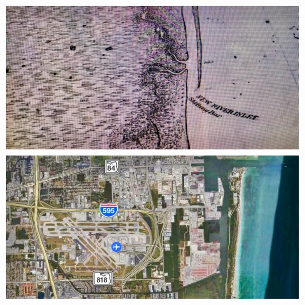
Comparison of 1883 historic map and Google Earth image 2017, Ft Lauderdale’s New River Inlet
Today I am sharing two creations of my brother, Todd Thurlow. Entitled “Ft Lauderdale House of Refuge/Life Saving Station,” and “Short Version,”they were originally for my mother, Sandra Henderson Thurlow and Timothy Dring’s “Image of America, U.S. Life Savings Service” book presentation at the Elliott Museum.
For me, Todd’s videos are mind-boggling as they bear witness to how much and how fast we humans can change the environment. Like an army of ants, we organize; we build; we destroy; we create…
By comparing and contrasting Google Earth maps of today with historic maps from 1883, 1887, and 1935, Todd’s “time capsule flight,” takes us through time and space to see the shifting sands of the multiple New River Inlets; Lake Mabel that morphed into Port Everglades; remnants of the forgotten Middle River that spread and contracted into new canals and developments; and of course, for mom, House of Refuge #4, that once rested north of a New River Inlet that today we can see is completely filled in, while beach-goers relax in reclining chairs like nothing ever happened!
Maybe one day we humans can use all this energy and ability to really fix our waters that have been destroyed during all this construction? Wouldn’t that be a dramatic video?
In closing, in the early 1900s, the New River… that was believed by the Seminoles to once be an underground river that collapsed and the Great Spirit revealed during an earthquake… was selected by modern-day humans as the “natural channel” to connect two of the largest drainage canals from Lake Okeechobee to the Atlantic Coast, the North New River/South New River, and the Miami.
The Albatross from the Rhyme of the Ancient Mariner, Samuel Taylor Coleridge 1772-1834.
Today the Florida Legislature convenes for year 2017. As we look down from the Heavens upon our great state what do we see? Mostly water… And yet water is such a problem for us. As the third largest state in the nation, and for the children of the future, it is imperative that we get this water problem straightened out….starting with the St Lucie River and the destructive discharges from Lake Okeechobee.
Because of Senate President Joe Negron, I am very hopeful. Let’s just hope the state legislature doesn’t kill the albatross. The albatross? Let us remember the story of the albatross.
Remember 8th grade? Remember reading Samuel Taylor Coleridge’s poem the “Rhyme of the Ancient Mariner?” You may at least recall these lines:
Water, water, every where, And all the boards did shrink; Water, water, every where, Nor any drop to drink.
The very deep did rot: O Christ! That ever this should be! Yea, slimy things did crawl with legs Upon the slimy sea.
About, about, in reel and rout The death-fires danced at night; The water, like a witch’s oils, Burnt green, and blue and white…
St Lucie River 2016 toxic algae bloom, JTL
In case you have forgotten, in this famous poem, the Mariner is punished by the crew for killing the albatross with no good reason, a sign of good luck and of hope, and thus bringing devastation upon all.
We the citizens have been in a sea of frustration and thirst with “no wind” for years; we have watched our water as before the tortured Mariner turn blue and green and white. But hark, the wind is blowing; the albatross is flying over… we have hope – a sign.
How shall the state legislature react? My hope is that they recall the lesson of the “Rhyme of the Ancient Mariner,” and remember, to whom they answer, and from whom they derive their power.
If you are from Martin or St Lucie County, I’m sure you remember….how the river movement came to an unexpected raging head during the Summer of 2013. It was after the River Kidz had held a gathering at the locks; and after the public had been screaming the St Lucie River was a putrid mess; it was after the Stuart News had been writing; and it was after organizations that had been working for years continued to bang their fists. Yes, after all this, that something new occurred…a surfer named Evan Miller posted on Facebook to protest the damaging discharges from Lake Okeechobee at St Lucie Locks and Dam. Evan had no idea! Social media was new. Shockingly, over 5000 people attended the event: mothers and fathers, children, grandparents, business people, local city and county politicians, environmentalists, people from afar, long time residents and newbies…..”everyone” was there…even Senator Joe Negron…
Things were never quite the same after this as a true movement materialized, and the seriousness of the matter was exposed. The event was reported across the state catching the attention of Florida’s most powerful and influential.
Shortly after, more protest were called by Miller who with help from Leon Abood, the beloved chair of the Rivers Coalition, reactivated and expanded the local Citizens 4 Clean Water chapter drawing members mostly from the younger generation.
Well, Evan called me yesterday and said “times are calling for a new kind of protest” and the young people of C4CW are calling for prayer and meditation, rather than protest in support of what is called the Negron Bill, Senate Bill 10, that calling for land purchase in the EAA for a reservoir.
“Wow,” I thought. How does the saying go? “God works in mysterious ways…”
C4CW’s Facebook page reads: “Rock painting with Children For Clean Water begins at 4pm at Sandsprit Park. Viral photo of thousands in prayer 5:30 pm. See everyone there to support the SB 10 bill in legislation now. Let’s get that land! #buytheland #senditsouth https://www.facebook.com/events/1874182396131037/?ti=icl
Sandsprit Park
3443 SE St Lucie Blvd
Stuart, FL 34997
Evan Miller at a Rivers Coalition meeting 2013From protest to prayer for the St Lucie River, photo Jenny Flaugh
C4CW’s Mission Statement: Take the challenge and become a Citizen For Clean Water by becoming part of the revolution to bring forward people who will lead the way for a cleaner and brighter tomorrow. When you become a Citizen For Clean Water you are taking on the responsibility of taking care of your environment teaching others your knowledge and stepping up to make a leading example for the rest of the world by becoming a voice for the voiceless. http://www.citizensforcleanwater.org
“Once You have tasted flight you will walk the earth with your eyes turned skyward, for there you have been and there you will long to return.” Leonardo da Vinci (1452-1529)
Original locks at Canal Point WPB Canal, JTLWPB Canal built in 1917 at Canal Point, JTL
Survey marker on original lock at Canal Point, WPB Canal. JTLThe beautiful iron and wood work on the original lock at Canal Point’s WPB Canal.IronworkPictured here: The original lock at Canal Point. I think this should be restored as a historic landmark as it was built in 1917 as part of the WBP canal and basically set us on the path we are today and is also a symbol of where we can go. The man on this lock reminded me of the story of the shared swing-bridge at Torry Island that once was part of the Roosevelt Bridge in Stuart. This will be the subject of today’s post.
2016 has been an incredible year, and 2017 will be as well. In 2016, both Lake Okeechobee and the St Lucie River blew up with toxic algae, and #GladesLivesMatter was established as a voice for a way of life that could be lost…
As far as 2017, as I write this post, deals are being cut, and advocates on both sides are working to get legislative support for their positions. But during this season of light, may we also remember our interests, as they hold things we share in common rather than apart: a Healthy Lake Okeechobee and St Lucie River, as well as Local Economic Prosperity for All are certainly goals both the Glades and the Coast desires…right now, in most areas of our combined worlds, this does not exist…
Yesterday, I toured the Glades once again with former Pahokee mayor, J.P. Sasser, someone I don’t always agree with, but definitely get along with. Someone who is teaching me a ton about the Glades, a history linked to my history, the St Lucie River/Indian River Lagoon….
Along the journey, a noteworthy thing happened right of the bat at Canal Point, our first stop. Here, I met an older gentleman fishing along the original locks of the historic West Palm Beach Canal. As I was taking photos, I thought I should introduce myself.
“Hello,” I said, extending my hand.
“Hello.”
“Catching much?” I asked.
“Not today, but usually, yes.”
“Do you live around here?” I inquired.
“No, Tequesta.”
“Wow Tequesta? That’s pretty far away…”
“Not really,” he said. “Maybe thirty minutes. I used to come here with my father in the 1950s.”
“That’s cool.”
“And where are You from?” He inquired.
“Stuart.”
The fishing line bobbed in the water. I saw noticed a dead gar fish float by. The water doesn’t look so good, I thought.
“Have things changed a lot?” I asked.
“Yes they have,” he said, “but not a lot out here at Canal Point. That’s why I come.”
An alligator silently swam the shoreline…
“You know your bridge is here.” the fisherman softly said,” pulling on the line.
“Wow, funny you should know that…my mom…she’s a historian. Torry Island right? They used part of the Roosevelt Bridge in Stuart to build out in here in Belle Glade in 1938. It’s still here today…a swing-bridge….right?”
He looked at me holding his gaze. “Right young lady, the bridge is here….”
J.P. called from the car. The fisherman and I locked eyes.
“The bridge is here.” I repeated.”The bridge is here.”
As we drove away, I wrote something on my notepad: “2017 #GladesCoastMatters … ”
_________________________________________
Torry Island Bridge is located in Belle Glade about a 15 minute drive around Lake O from Canal Point.
“The story of the bridge’s origins flow smoothly from Corbin… The 1928 hurricane that ravaged the Glades set in motion the chain of events that would bring the bridge to Belle Glade. The storm destroyed the original dike that surrounded the lake. To build the replacement dike, the federal government spooned out a canal, separating Torry Island from Belle Glade, and used the dirt for the dike. The new canal, called the Okeechobee Waterway, needed a bridge. In 1938, state contractors built the Point Chosen Bridge, replacing a pontoon bridge with a swing bridge that was built in 1916 and relocated from the St. Lucie River near Stuart. The bridge consisted of the movable portion and wooden trestles on each end.” Associated Press article, 2009.
Merry Christmas and Happy Holidays to all my readers! See you in 2017!
Jacqui
This is the swing bridge that used to be in Stuart on the Roosevelt Bridge but is now part of the Torry Island Bridge in the city limits of Belle Glade.Torry Island, Belle Glade.The swing-bridge looking across the rim canal around Torry Island.The Bridge Between Us…JP and JTL.J.P.’s bumper sticker
My bumper sticker/sHistoric map of the Glades showing cities. Canal Point upper left and Belle Glade further west and south. WPB canal is in Canal Point and the Torry Island Bridge is in Belle Glade.
Flying over the black gold of the EAA. JTLFields in Pahokee, JTL
Road Trip Series.
Since I began my Glades “Road Trip” Series, I have read three books by Lake Okeechobee historian, Laurence E. Will: Okeechobee Hurricane, Swamp to Sugar Bowl, and A Cracker History of Okeechobee.
These books hold amazing stories of the Glades; if Mr. Will hadn’t written, there would be very few first-hand accounts of farming that became a Florida mega-industry just over the first half century of the 1900s. Today, I will transcribe some of his most interesting descriptions of Lake Okeechobee, the magical landscape that was transformed into today’s contoversial Everglades Agricultural Area, for none other than its MUCK.
EAA below Lake Okeechobee. (Public map SFWMD)Photo of pond apples also know to locals as custard apples in Big Cypress- shared on Flicker by photographer Mac Stone, allow us to envision what this incredible forest looked like. 32,000 acres rimming the southern and eastern shore of Lake Okeechobee. The best muck built up over thousands of years under these roots that worked like a seine as the lake overflowed its edge then running south through the sawgrass. The Everglades….
Florida Memory Project, photo by John Kunkel Small 1869-1938.
pond apples
Photo from Swamp to Suagrland, showing pond apple with moon vines around Lake O. (Lawrence E Will)
Close up of small pond apple on Torry Island, by Lawrence E Will.
When I was on my recent tour with former mayor of Pahokee, J.P. Sasser, I learned the nick-name for Pahokee is “The Muck,” named so for the “black gold” soil that accumulated over thousands of years under the roots of a custard apple forest that rimmed the lake. (Kind of like fresh water mangroves today in the Indian River Lagoon.)
When one drives deeper into the Glades, one finds similar nick-names or “muck mottos,” that have to do with the muck. For instance, Belle Glade’s motto is “Her Soil is Her Fortune;” Clewiston’s is “America’s Sweetest Town,” and South Bay’s refers to its highways, “Crossroads of South Florida,” named so for its intersection of two major roads, East-West State Road 80, and North-South, U.S. Highway 27, roads that get one into the muck, or out of it….
Will first experienced the Lake in the early 1900s as a boy when his father was developing Okeelanta, located about four miles below today’s South Bay. Okeelanta, today a mill location for the Fanjul holdings, was located not in an apple custard forest, but rather in the miles of sawgrass lying south. Although the soil here is excellent, it is different, more peaty and not as “mucky.” Thus the most productive lands lie closer to the lake, deep in the MUCK.
Here is a moving account by Will about the land of muck in “Cracker History of Lake Okeechobee:
“Before the dredges crashed through the custard apple woods to start the first canals, the lake most always stayed high and clear, unbroken except for those islands Kreamer, Torry, and Observation. When I first saw the lake it was still wild. Excusing the trifling settlements at Utopia, Ritta, and Tantie, a score of fishing camps, and the openings to four unfinished canals, it’s swampy shores hadn’t changed since Zachary Taylor found the redskins or probably not since DeSoto anchored in Tampa Bay. It sill was just as the good Lord had fashioned it. The lake was lonely Mack, silent and mysterious as well. But I tell you boy, it was beautiful, and sort of inspiring too.”
Will was absolutely pro development, pro farming/agriculture, but he, like most of the old timers, recognized the tremendous awe-inspiring beauty of the place.
Most all the natural beauty the lakeside shoreline in Martin County, where the FPL Power Plant is today, and north to the town of Okeechobee has also been radically altered as well.
FPL solar plant and “cooling pond” in Martin County looking west towards “Barley Barber Swamp.” This area was once a forest of mostly giant cypress trees and others. JTL
Excerpts by Lawrence E. Will:
“Dense forest ringed the lake around. Along its northern half water oak, maple, cypress, potash, rubber and palmetto trees crowded each other on the lakeshore ridge…the south shore and half way up the eastern side was something else… Here were custard apples, a solid belt of tropical trees, blanketed with a moonvine cover, which stood, two miles or more in width, without break or opening, from near Clewiston’s Sand Point, slap around to Port Mayaca. 32,000 acres of custard apple woods there were, the most of these trees, I wouldn’t doubt, on the whole blamed continent of America.”
“…Although the shores were for the most part black muck, low and flat, there were some fine sandy beaches too. Along the east side for eighteen miles lay beautiful East Beach…”
“Now if Zachary Taylor or Hamilton Disston could return to Okeechobee they would find that farmers have exterminated the custard apple woods. Highways, service stations, super markets and housing projects have replaced the cypress, rubber and maple trees along the ridge. A levee occupies the onetime shore and drainage has lowered by half a dozen feet the water’s elevation. Tractors cultivate the former seining grounds, and unless you as old–and no amount, as some of us, your never heard of town of Tantie, Utopia or Ritta. Civilization has re-made the lake and I’d be the last to say it isn’t better so, but the lakeshore’s one time natural beauty is long gone, and man, wasn’t that old lake a fascinating place.”
Well, to the land of Lake Okeechobee! For all she was, and for all she is. It’s enough to make one exclaim:”What The Muck?!!!”
Today we continue our road trip in the Glades atop the Herbert Hoover Dike.
In the short video below you can see my Glades tour-guide, former mayor JP Sasser, driving, –in his hometown of which he knows so much about–Pahokee. On the right lies the city, and on the left is Lake Okeechobee. A precarious position indeed!
Pahokee is actually unusual in that this little town is “high-ground.” According to JP, about 13 feet above ground. This is not the case for most of the Glades.
Interestingly, in the video, JP discusses how the Army Corp recently decided where to strengthen the dike in Pahokee, because if they had extended it out 500 feet as was done along the rest of the eastern shore, the town of Pahokee would have been covered up as it is located right beside the dike.
Lake Okeechobee’s dike and its history are fascinating just as is all our area of the Northern Everglades including the St Lucie River/Indian River Lagoon that in 1923 became the primary exit point for waters that could no longer flow south after the Herbert Hoover Dike was built.
According to historian and Gladesman Lawrence E. Will:
“…following the floods of 1923 and 1924 water stood over farm lands nearly the entire winter. To protect the farms, the state of Florida had then constructed an earthen dike along the whole south shore. It was some five to eight feet above ground level but this dike was never intended to withstand a hurricane.”
Regarding the expansion of the dike, as the “Herbert Hoover,”after the horrific hurricanes of 1926, ’28 and again in again in ’49, Mr. Nathaniel Reed notes in his writing “Lake Okeechobee and the Everglades: “The Corps of Engineers studied the average size of Lake Okeechobee and designed a dike around it…”
Now this is where things get very interesting.
“The average size of the lake….” what’s that?
Now if we look at this slide taken from a 2016, presented by Jeff Sumner, who was at the time Office Chief State and Agricultural Policy, SFWMD, it shows the size of the lake pre-development. One can see it was about once about 1000 square miles in size and today it is 750.
The False Edge of Lake Okeechobee, SFWMDThe checkered fields were once lake bottom. L. E. Will, “Okeechobee Hurricane”L.E. Will Swamp to Sugar Bowl. The Glades area, today’s Everglades Agricultural Area has become one of the most productive agricultural areas in the world…
Of course the size expanded and contracted based on rainfall, but one still gets the point…this lower area was nature’s shoreline, a boggy marsh with rivers leading into a sawgrass “river of grass” bordered by a forest of over 30,000 acres of Custard Apple trees that functioned like mangroves extending up to five miles or more south into what is today’s Belle Glade. As Mr Lawrence Will would have said: “Who wudda thought!” (http://museumoftheglades.org)
Pahokee is in upper right. Map Laurence E WillThe lake once went further south here and there following the rivers to Hwy. 80Land ownership todaySen. Joe Negron’s map for land purchase
I would like to thank former mayor of Pahokee, JP Sasser for on November 29th guiding me through a seven hour tour of the Glades! At first you may think JP and I are unlikely “friends.” Actually we have something very much in common in that we have both been mayors of small Florida cities.
Yes, there are also a few serious things we don’t have in common such as our opinion regarding land purchase in the Everglades Agricultural Area, (EAA), for a reservoir to alleviate the destruction of the St Lucie River. Also, Sasser has written extensively about concerns regarding the direction of the Rivers Coalition. I have been on the Rivers Coalition Defense Fund for six years. Mayor Sasser and I have not always been on the same page. For me this is O.K. JP and I having differences of opinion shouldn’t preclude working together. At this point in my river journey, I am going to do all I can to build relationships. To find common ground. “Common muck” should I say?
Anyway, enough politics. My tour was awesome! For this post, I will just concentrate on Pahokee.
JP and I met at Canal Point, at the USDA Sugarcane Field Station that dates back to 1920 about ten miles south of the Martin County/Palm Beach County line at the WPB Canal.
Pahokee has about 6000 residents. It has beautiful new schools. Many of the lands are owned by family farmers and the Fanjul family. The population is about 80% black and 20% white. Everyone I met was friendly and happy to see me.
Locals fishing at marina
JP asked me where I wanted to go. I asked him to take me to the Pahokee Marina and Tiki Bar that he so famously worked for during his mayorship. This marina is within view of Port Mayaca in Martin County. JP’s dream was that this marina would become the basis for economic development and diversity of Pahokee. The city desires economic development. (http://www.mypalmbeachpost.com/news/business/guy-harveys-resort-chain-eyes-site-in-okeechobee-c/nmwGw/)
I learned that Pahokee unlike much of the Glades is thirteen feet above the lake. It is high ground. The town is just a few miles long and 500 feet wide right along the dike. One sees dike, houses, road and then fields…Thus when the ACOE recently wanted to make improvements and “go out 500 feet out from the dike” they would have basically had to had to knock down the city.
I learned that much of the lands close to the Lake were covered with Apple Custard Trees that had been removed in the early 1900s and thus the lands have excellent deep muck soil that grows not only sugarcane, but sod, corn, vegetables, and supports tree farming. Pahokee is known as “Muck City.”
JP then took me off the beaten track to see his horses and donkeys. So here is something else we have in common. A love of animals!
We drove on…JP showed me the remains of the Pelican River which led to Pelican Bay that I had read about in my book. This was the area where the Palm Beach Times reported over 400 dead after the 1928 Hurricane. I tried not to imagine…
We then drove to Pahokee’s original graveyard that had to be moved along with its resting bodies to Port Mayaca in Martin County after the 1928 Hurricane. There was a plaque that listed those who had been buried there. A sad thought, but here is another way Martin County and the Glades are connected.
We visited the airport. Very nice. Right along the lake. In fact this area was once lake bottom. Bizarre. Hmmm…My husband Ed would like this airport I thought. More possibilities for economic development?
Again back to the dike. It always goes back to the dike…
We checked up on ACOE repairs where they had draped the pipes carrying water to the fields over the dike like spaghetti and then JP took to me to lunch….
Part #2 will be entitled: “The Best Fried Chicken of My Life.” Please see photos below.
JP at Pahokee MarinaDriving on road atop the dike by marinaView from dike looking south. Homes stand right next to the dike.Old Pelican RiverTree Farm looking from dikeJP’s horese and donkeys
Original Pahokee graveyard at base of dike
Old GraveyardPahokee’s nice new roads with lovey houses on right and fields on other side of roadCanal and control structure to fieldsLocation of airport, once lake bottom
JPRepair of dike ACOE with water for irrigation from lake over dike so they can get to culverts
The Fanjul Brothers, Plantation Services Land Report 2012
“Who Owns the Land? Mapping Out Florida’s Water Future.”
Stofin Co. Inc. is #7 on the Treasure Coast Regional Planning Council’s (TCRPC) map of land ownership in the Everglades Agricultural Area, (EAA). These lands lie on the eastern side of the EAA and comprise 7,189 acres. Stofin Co. is affiliated with Fanjul Corporation more widely known to river activist as “Florida Crystals.” As we know, Fanjul Corporation is a large sugar and real estate conglomerate with interest in Florida, the Dominican Republic and soon to be in the brothers’ homeland, Cuba, once again. The family is very influential in all politics and donates extensively to both the Democratic and Republican parties.
We can see by doing just a bit of research that some of the same officers of Fanjul Corporation are also listed in Stofin Co. Inc. such as Erik J. Blomqvist and Luis J. Hernandez.
Looking at our TCRPC map I have colored #7 parcels in orange just as #2 Okeelanta Corp. and #3 New Hope Sugar Co. were. As we learned earlier those too are Fanjul Corp. lands. I have just added a purple dot to differentiate. So far all in ORANGE below is Fanjul holdings.
It is interesting to compare the TCRPC map with the historic maps also below and note the “shape” of the original “river of grass” before it was dammed and destroyed by agricultural development in the EAA. Note how the river veered off to the right, or in an eastly direction. Surveyor, Chappy Young’s map shows the westerly development over the years into the “Everglades’ agreeed boarder” from the east. We have swallowed her up in every direction. She needs to be restored. It only makes sense that some of the overflow water from Lake Okeechobee destroying the St Lucie River/Indian River Lagoon is allowed to go south again. Thank you for reading my blog and for caring about the health of the St Lucie River/Indian River Lagoon and the Florida Evergldes.
Historic map from 1948 book “Lake Okeechobee” written in 1948 by Alfred Jackson and Kathryn Hanna as part of the Rivers of America Series.War map of the Everglades created during the Seminole Wars, 1856.West of the red lines shows the edge of what was once the Everglades in South Florida. Development has crept and continues to creep over this edge. (Photo/map courtesy of Chappy Young,/GCY Surveyors, 2014.)Senator Joe Negron’s proposed aquisition map in the EAA, 2016.
This email came in via my brother Todd this morning, amazing how similar the paths of the two hurricanes are. I thought I’d share. In any case, to all “be safe.” Jacqui
“Attached is the 1979 Hurricane David Track vs. the Hurricane Matthew track and forecast track.
The Great Southern Butterfly, Flicker photo by Christina Reiman, 2013.My attempt to capture an image of a Great Southern Butterfly in Sewall’s Point Park stopping to eat along the way….
You may have noticed them recently, hundreds, if not thousands, of white traveling butterflies moving south along our St Lucie River/ Indian River Lagoon?
I’ve noticed them, and was so amazed that I actually got out of my car and tried to video tape them. Standing at the Sewall’s Point Town Hall as they darted past, I thought to myself: “Who are these butterflies? I wonder where they are going? What a sense of purpose!”
Flying low, cars zooming past, drafts pushing their slight weight up over vehicles, and sometimes getting hit, they fall like white petals onto the street. Resembling a slow moving army of the American Civil War, they are unfazed by their opposition and keep moving in a formation invisible to the human eye.
So brave. So together—they know where they are going.
Known as the “Great Southern Butterfly,” this pretty, “aquamarined-antennaed” insect breeds in the remaining salt marshes of the Indian River Lagoon, laying eggs commonly on saltwort and reproducing after rains.
During the 1930s and beyond, tremendous percentages of the Indian River Lagoon’s salt marshes were flooded for mosquito control purposes; thus certainly our present army of butterflies is much fewer today than in the past.
These hardy little butterflies can travel more than 40 miles in two days! Can you imagine? I admire their stamina, natural intelligence, and determination. They are a metaphor for our goals and for our lives as we try to save the St Lucie River/Indian River Lagoon.
In honor of their efforts, and the lessons they are teaching, I have determined to temporarily drop my speed while driving, I hope you will too. 🙂
Humankind has not woven the web of life. We are but one thread within it. Whatever we do to the web, we do to ourselves. All things are bound together. All things connect. —Chief Seattle, Duwanish Tribe, Washington
Spiny-backed orbweaver spider. (Public photo)
As I have mentioned before, living close the St Lucie River and Indian River Lagoon, I look to nature for inspiration and this year inspiration has surrounded my house in the form of tiny spiny-backed orbweaver spiders. My husband and I have seen these very small spiders, half the size of a dime, throw a connecting web to their interior design at least twenty feet if not more. It is absolutely remarkable, seemingly impossible, that these little creatures can do this.
Although you can’t see it, the spiny-backed orb weaver spider has a web across the trees in the front of our house. From one side to another between the trees is at least 15 feet. (Photo JTL)
Their beautiful webs blow in the wind reflecting sunshine like baskets catching insects. From what I have read, it is the female that makes the web and though I have never seen one, the smaller male is somewhere hanging on a single thread beside her.
Web in our yard…(Photo JTL)Inner web up close… (Public photo)
I learn a lot watching these little spider. First of all, that “you can do something seemly impossible”–it’s in you—. Second, I often see their webs which must have taken hours to weave get destroyed by birds, rain, wind or even me accidentally running into them–they just “quickly crawl back up and start right over again”…This is a good life lesson.
I have also learned that butterflies must be able to see spider webs as I have watched the many in my yard purposefully navigate away from them. Pretty cool.
In fact, I think that after the many months of the spiny-backed orbweaver spiders living in Ed’s and my yard, (much more so since we took out the grass and stopped using fertilizer and sprayed pesticides) they are learning to adapt to where we walk. I swear they now build their webs right in front of our walkways and doors but leave a large open space for us to walk though!
Its colors are red, black and white. (Public photo)
They do not bite and are they not aggressive…..like all of God’s creatures, they are my friends, and I learn from them.
…My mother used to sometimes say: “The webs we weave……”
Seeing the little hard-working spiders each day makes me mindful that, yes, we are all connected, and that I choose where and how to build my web.


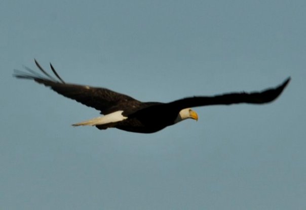 History DDT


 Sugarcane and Indians