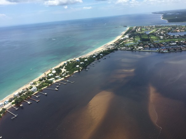
 Tales of the Southern Loop, Stuart to Boyton, Part 1
Tales of the Southern Loop, Boyton to Miami, Part 2
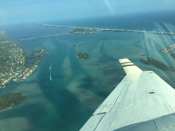
Tales of the Southern Loop, Miami to Tavernier, Part 3
Tales of the Southern Loop, Tavernier to Marathon, Part 4
Tales of the Southern Loop, Marathon to Key West, Part 5
Tales of the Southern Loop, Key West to Cape Sable, Part 6
Tales of the Southern Loop, Cape Sable, Marco Island, Ft Meyers, Moore Haven, Clewiston, Stuart, Part 7
I’m a bit late in getting this final Southern Loop published. Between the presidential election, Tropical Storm Eta, seemingly endless overcast skies, ACOE discharges from Lake Okeechobee, and resurging Covid-19, I have had a hard time keeping myself on track!
This post is split into seven sections for dates 9-17-20 though 9-22-20. It shares highlights of the second half of the Southern Loop along the waters of Cape Sable, Marco Island, Ft Meyers, Moore Haven, Clewiston, and back to Stuart. A fantastic trip!
I. MARCO ISLAND, GULF OF MEXICO
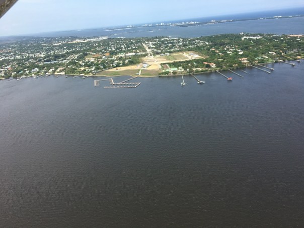
 Having left Cape Sable, approaching from the Gulf of Mexico, Marco Island looked like a city rising from the water. It is actually the first and largest of a chain, that beyond it, comprises Ten Thousand Island National Wildlife Refuge and is adjacent to Everglades National Park.
Well before the era of high rise resort hotels, the island’s beach was surrounded by mangrove forests, and the Calusa Indians thrived here for possibly thousands years. Docking at Marco Island Marina was one of Ed and my most difficult experiences with the winds tearing along the seawalled canal as we struggled for direction. Once there, it was paradise. We wish to go back.
-Approaching Marco Island in the Gulf of Mexico -Marco Island is part of 10,000 Islands
II. FT MEYERS, CAPE CORAL, CALOOSAHATCHEE
The following day, after running just offshore in the Gulf of Mexico, Adrift arrived at Tarpon Point Marina, and docked with out issue- a familiar spot as this is where Ed and I had taken trawler classes in 2018. We had reached the Caloosahatchee!
That afternoon, Ed and I arranged a visit with Cape Coral resident, friend, and long time River Warrior pilot, Dave Stone. Also joining us was advocate and west coast fishing expert, Captain Chris Wittman, Captains for Clean Water.
Dave and Chris reminisced their history together documenting the blue-green algae discharges from Lake Okeechobee that exacerbated the horrific red tide in the Gulf of Mexico in 2018. Dave and Chris’ Facebook Live images helped turn the tide with the election of Governor Ron DeSantis and Executive Order 19-12.-
-Dave Stone and Chris Wittman visit Adrift In the following days, Ed and I made our way to Moore Haven. The channelized Caloosahatchee is 67 miles long with quiet, rural towns “Olga” and “Alva,” and two locks (Franklin and Ortona), along the way. During the course of this lasting and beautiful day, I actually heard Ed say: “I think I could retire here.” That was a first!
Of course like everything else, although there remains great beauty, from an ecological view, the story of the Caloosahatchee is a bit depressing . In the late 1800s, it was the first water body altered as Hamilton Disston plowed through the oxbows to change its course and blew up the rapids to drive the river through the sawgrass marsh at Lake Hipochee and then on to Moore Haven. This unnaturally connected the Caloosahatchee to Lake Okeechobee. Like the St Lucie, the Caloosahatchee has been plumbed to drain diked, and polluted Lake Okeechobee. This drain the swamp “progress” of the time, affects Florida’s waters today at great cost.
-The Caloosahatchee connects the Gulf of Mexico to Lake Okeechobee -The Olga bascule bridge
 -A lovely home along the channelized Caloosahatchee River
 -Cows cooling off. Hey! What about Best Management Practices? 🙂
 -Ed talking to the ACOE at Franklin Locks
  -Historic swing bridge at Fort Denaud, near La Belle; prior to dredging and drainage, just north of here were the rapids of the Caloosahatchee
 -Ed and I hold the ropes, Ortona Locks and Dam, near Ortona Prehistoric Village
III.MOORE HAVEN AT CALOOSAHATCHEE & LAKE OKEECHOBEE
By the time we reached Moore Haven at the mouth of Lake Okeechobee, the sun was getting ready to set over the Moore Haven Bridge. Hospitality was in the air and Ed and I were immediately assisted to dock by fellow travelers John and Susan Brady of Kemah, Texas, who now live on their boat Sunset Drifter. We had a delightful visit and got great tips for “living aboard.”
As I looked out towards the lake, I was ecstatic to see the famous “Lone Cypress” tree was only a stone’s throw away. This tree has been a Lake Okeechobee landmark for hundreds of years. I found it rather ironic that it now has a sprinkler next to it! Considering it was living in a sawgrass marsh in more than a foot of water 140 years ago, this is the ultimate metaphor for Everglades’ change.
-Visiting with the Bradleys at the Public Docks of Moore Haven
 -Sunset over the Moore Haven Bridge, also known as, Highway 27
 -Me standing with the Lone Cypress today, 2020
  -A sprinkler!?
  -Historic marker
 -Post card of the Lone Cypress at mouth of Lake Okeechobee ca. 1880, Florida Memory.
IV.MOORE HAVEN LOCK ENTERING LAKE O RIM CANAL
In the morning Ed and I waved goodby to the Lone Cypress and to the Bradleys. Then the craziest thing happened. We were going through the locks at Moore Haven and there was substantial floating vegetation. To my surprise, I saw many marsh rabbits floating on water hyacinth or actually in the water literally up to their ears. We have marsh rabbits at home along the Indian River Lagoon, but I have never seen them in deep water. My emotions got the best of me and I did the unthinkable. I abandoned my post.
“Where is the net?” I shouted as I climbed the stairs leaving the rope hanging against the lock’s tall cement wall. “Ed I’m going to save the drowning rabbits!“
Ed was not pleased, yelling, “Jacqui, rule number one, never abandon your post!”
The trawler banged against the lock, the waters rushed in, and I could not reach the bobbing rabbits, so finally I gave up and re-grabbed the line. We passed through the lock into the rim canal of Lake Okeechobee. I silently watched as the rabbits floated by. Ed gave me that look that means he is “not happy.”
-Marsh rabbit with only ears and face above water  -Video of marsh rabbits trapped on floating vegetation below, hit arrow
-After the fiasco at the Moore Haven Locks, Ed and I continued towards Clewiston. We didn’t speak for hours. I actually sat on the bow and cried thinking about how much humankind has altered this planet. But I got ahold of myself. The wind was picking up and many birds were flying overhead -a sign of changes to come.
I checked to see if there was cell service. There was, so I looked up marsh rabbits and to my chagrin, I learned that they are “excellent swimmers.” I looked towards the helm.
“Hey Ed?”
“What?”
“Marsh rabbits can swim!”
His laugh echoed over the water. “Good thing you didn’t pull them onto the boat!”
“I guess so. But nonetheless, that was NOT NORMAL! ”
-The rim canal
V. CLEWISTON RIM CANAL/LAKE O
When Ed and I arrived in Clewiston it was very stormy, we took refuge at Roland Martin Marina. Captain Sam, a war veteran with feathers in his cap, helped us dock. I knew with this weather we’d be here for a few days so I got out my phone and called Clewiston Mayor, Mali Gardner who I’ve known for many years. Over the coming days, she and her husband displayed the warmest hospitality taking Ed and I on a tour of the area. So nice!
-After docking with the help of Captain Sam, Roland Martin’s Marina, Clewiston -Tour with Mayor of Clewiston, Mali Gardner. We sometimes have different interests, but we have great respect for one another.
Welcome to Clewiston!  -Famous Clewiston Inn with wildlife mural
 -Mayor Gardner shows us the original shoreline of Lake Okeechobee where today many beautiful houses sit
 -Historic Clewiston homes and drainage system
 -Ed at the Clewiston Museum that houses the mind blowing fossil findings of Mark Renz from LaBelle
 -With Mary Anne Martin owner of Roland Martin Marina in Clewison. Ms Martin is a huge advocate for Lake Okeechobee. For years she has voiced against spraying of chemicals on floating vegetation, and works for the burning of lands when lake levels are low to regenerate Lake Okeechobee’s ecosystem. Lake Okeechobee is famous for its bass fishing.
  -Merchandise for sale and for display at Roland Martin Marina

VI. LAKE O
-After three days the wind died down and the S-310 lock to Lake Okeechobee was opened. It had been closed for high water for the first time in years. Ed and I headed home to Stuart. Lake Okeechobee was wild and windy, like an ocean itself. A flock of seagulls followed us 25 miles ! I threw bread from the upper helm and the talented birds, like acrobats, caught pieces in mid air. It was so much fun.
During the trip, I looked for algae on the lake but saw none and pondered the changes that have altered this liquid heart of the Everglades…
-S-310 to Lake O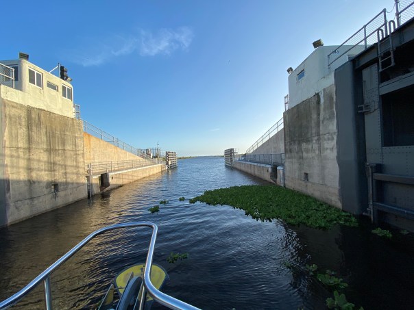 -Ed on open Lake O!
  -Flock of seagulls followed us all the way home across Lake Okeechobee!
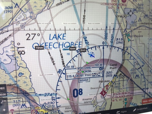
This Google Earth image shows our path from Clewiston, across Lake O to the C-44 canal adjacent to Indiantown. The C-44 connects to the St Lucie River bringing us home to Stuart, Florida, in Martin County. 
VII. STUART, C-44 Canal, ST LUCIE RIVER
S-308 Port Mayaca locks at Lake O to C-44 canal -Trees along the banks of the C-44 Canal
 S-80 St Lucie Locks and Dam, continuing C-44 to St Lucie River
 -C-44 is very impaired from Lake O, and basin agricultural and development runoff
  -After a long journey, a familiar sight, the Roosevelt Bridge opens to welcome us home to the Harborage Marina. Much of the C-44 Canal and upper St Lucie River were under water due to King Tides. This salt infusion is healthy for the St Lucie River as like the Caloosahatchee it is unnaturally connected to Lake Okeechobee.
-Roosevelt Bridges, Stuart, home sweet home back at the Harborage Marina 

 After the almost three week trip, it was wonderful to be home. Ed and I had accomplished our goal and our promise to each other. Working together and experiencing our state’s waters first-hand was a life changing experience.
When we docked with out a hitch like pair of old pros, we both became strangely quiet. Home is wonderful, but somehow, we knew from here on out, there was nothing that could compare to being Adrift.


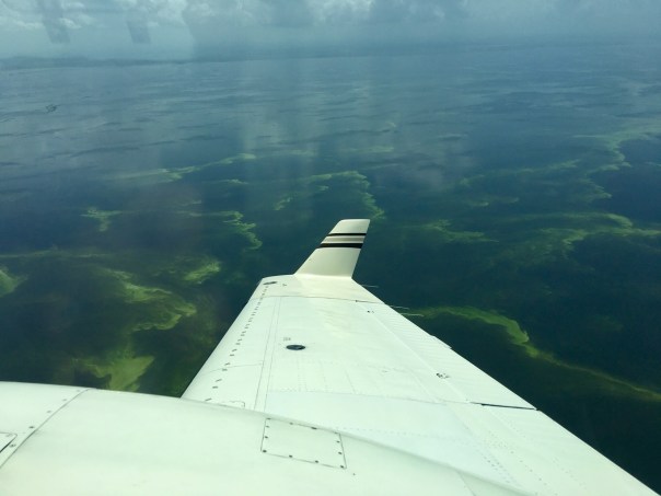


 Entrance to Caloosahatchee on west side of lake and near Clewiston Bloom is all through lake.


