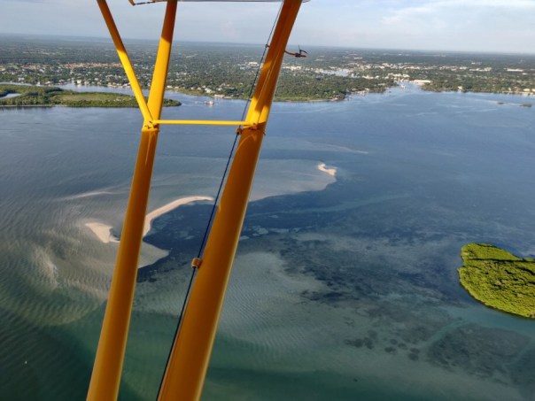
My husband Ed took up the Baron today. His aerials are a potent reminder that even though the water has been looking “great” near the Sandbar in the St Lucie River/IndianRiver Lagoon, there is algae literally at “our front door.”
-Structure 308 at Port Mayaca, Lake Okeechobee 6-15-21, 1:18 pm -all photos Ed Lippisch-Just west of S-308 at Port Mayaca, Lake Okeechobee-North of S-308 at Port Mayaca, Lake Okeechobee along Rim Canal-Lake Okeechobee north of Port MayacaSt Luice River/Indian River Lagoon residents have been fortunate that the ACOE, due to the presence of algae, made decisions this 2021 not to discharge as much to the St Lucie. This began on April 19, 2021 when the ACOE S-308 “Sediment Study” was postponed due to high levels of cyanobacteria in the toxic blue-green algae at the S-308 gate. The HAB DEVIATION the ACOE had put in place made this possible.
Looking broadly, my brother Todd’s website EyeOnLakeO shows that although cloudiness has made satellite images difficult, the majority of the algae in Lake Okeechobee is presently on the west side, and the Caloosahatchee, unlike the St Lucie, has to take water to to maintain salinity levels. Thus they have algae in their river system right now.
As I sit here, rain is pouring down. We know dry season is over and rainy season has begun. What is critical is that the ACOE does not open S-308 and S-80 this year as our seagrass beds are just starting to recover after years of Lake O discharges. S-80 is the gatekeeper for the St Lucie River/Indian River Lagoon. For now, S-80 is closed. In order to keep it closed for 2021 please write the ACOE at: PublicMail.CESAJ-CC@usace.army.mil
SFWMD canal and basin map. C-44 canal is the canal most southerly in the image, note S-308 and S-80.
-S-80, St Lucie Locks and Dam now closedI am very pleased that Lake Okeechobee’s level is down to 12.50 feet; however, we know that could change quickly due to hurricane season. We must remain vigilant.
In closing, I want to share one cool thing that happened during Ed’s flight the thad nothing to do with algae. He saw the Goodyear Blimp!
Thank you Ed for continuing to be our “eye in the sky” since 2013! To view the SFWMD’s most recent comprehensive Ecological Report click here. There is a lot more to the system than us! 🙂
-Ed and Jacqui walking the bridge over the St Lucie River/Indian River Lagoon, 2021. Working for the betterment of the SLR/IRL ’til the end of time!
You may have seen my most recent Lake Okeechobee post from July 25, 2020? After algae aerials since May 8th, my dear husband, Ed, said he saw no algae. Ed and I had a back and forth -me saying the algae “was hiding.” Hiding in the water column. Ed saying it was gone. Well, guess what? I was correct…
Today, July 29, only four days later, the cyanobacteria is back. There was one positive to it all. Ed added to his long list of esteemed flight guests, Ft Meyer’s Captains Chris Whitman and Daniel Andrews – the faces of Captains for Clean Water. The east and west coasts of Florida have been advocating together since the days of the Sugarland Rally in 2013. East and west, an important water alliance.
According to Ed, “the algae was bright and visible over the majority of the western, and southern-central portion of the lake, but became less dense as one approached Port Mayaca.”
“Were you surprised the cyanobacteria had returned?” I asked.
Ed had a very simple answer: “yes.”
Ed also said it was a great to hosts the Captains. What an honor.
Below are some of Ed and Captain Daniel’s photographs from Wednesday, July 29, 2020. You will see, with the sun shining, the lake is once again, visibly, full of algae. This is important documentation for the Army Corp of Engineers as we possibly face a very wet weekend.
Havens and Hoyer diagram from study of cyanophyte movements.Courtesy, Joe Gilio.Courtesy of Captain Daniel Andrews-off southwestern shore
Courtesy of pilot Ed Lippisch-southern to southwestern shore of L.O.
Documenting St Lucie River and Lake Okeechobee, Saturday, June 13, 2020
Today’s post includes two sets of photos taken from two different planes: the Supercub and the Baron. The Supercub is the classic yellow “River Warrior” open-air plane, and the Baron is a closed cockpit twin-engine with the distinctive upturned wing-tip. The Supercub can fly low and slow, the Baron can fly higher and faster. Both offer unique perspectives to photograph our waterways.
I.
Dr. Scott Kuhns and Steve Schimming shared photos taken from the Supercub in the morning hours of Saturday, 6-13-20. Scott uses a quality Nikon camera thus his photos offer a wider or closer perspective. Thank you Scott and Steve, long time River Warriors and friends. Their photos reveal the coffee color of the St Lucie following torrential rains.
Canal systems dumping fresh water into SLR presently is primarily from C-23 and C-24. Good for the S.L. the SFWMD is advocating and the ACOE is allowing the water in the C-44 to run back into L.O. as lake was not in “ecological envelope.”Note: presently there are no discharges from LO into the SLR. ~Image SFWMD
St Lucie Inlet
Confluence SLR/IRLLooking southt to St Lucie Inlet and Jupiter NarrowsSeagrasses looking bleak
SandbarSandbarSandbarBird Island IRLPhotos Dr Scott Kuhns: Sewall’s Point
II.
This next set of aerials was taken by my husband, Ed Lippisch, and myself the same day, 6-13-20, a few hours later, closer to noon. Again, it is important to note the St Lucie area recently experienced particularly heavy rains, only Broward County and parts of Miami- Dade had more. So we can learn about this, I am sharing the most recent Water Conditions Report of the SFWMD for details of all the St Lucie and all south and central Florida. See link under Rainfall Distribution Comparison slide below.
The first group of photos from Ed and I in the Baron is of the St Lucie River and the second set is of algae blooms in Lake Okeechobee. NOTE THE ACOE IS NOT DISCHARGING INTO THE ST LUCIE AT THIS TIME.
We continue to document and thank all who are working towards projects and ways of life that better water quality in the state of Florida. We know what we need to do!
Sailfish Flats IRLExiting St Lucie Inlet looking south along Jupiter Narrows/Jupiter IslandPlume becoming visibleLooking back again into southern edge of SL Inlet
Now back at the St Lucie River and St Lucie Inlet at higher altitudeSt Lucie River/Indian River LagoonSailfish Point St Lucie River/Indian River LagoonPlume from higher perspectiveVeteran’s Bridge in Palm City looking back to Stuart, note Witham Field and ocean in distanceCircling around- Hobe Sound looking north to St Lucie Inlet.Heading west over Atlantic Ridge natural areaApproaching Lake O. FPL cooling pond visible.S-308 at L.O. and C-44 CanalMy brother Todd Thurlow’s website shows that algae in L.O. is now showing on low resolution satellite imagery: Terra, Aqua, Suomi: http://eyeonlakeo.com/LakeO3x7days.html; http://eyeonlakeo.comalgae bloom southern rimalgae bloom like this was basically throughout southern area of lake, but denser in some areas and not so dense in others….Ed’s palne GPS, present location south L.O.South Lake O over southern rimLakeO lapping towards Port Mayaca not FPL cooling pond, this area is by far the most algae ridden
Lake OLake OLake OLots of algae in Lake Okeechobee
MOVIE:
Now after flying west again over Lake Okeechobee algae here as well but more spread out
First of all, let’s recognize that we are stressed out enough social distancing due to the coronavirus. Nonetheless, for our waters, we must pay attention on every front. Right now, the St Lucie River and nearshore reefs are absolutely beautiful, and there is not a threat from Lake Okeechobee or area canals as it is not raining very much. Lake Okeechobee is at 11.85 feet NVGD, therefore, the chances of discharges into the St Lucie River are basically none. If another Hurricane Dorian comes this summer, that could be a different story.
We know our waters suffer from nutrient pollution overdose. Thankfully the State Legislature under the leadership of Governor DeSantis is now paying attention. It will take some time for the bills passed this past legislative session to bear fruit and some will need to be expanded, but when it comes to our waters we are in a better position politically this year and last year than in recent years.
Nonetheless, we must continue our advocacy and continue to document.
The above Jacksonville Army Corp of Engineers map distributed during the March 31, 2020 Periodic Scientist Call shows how much water is going where from Lake Okeechobee. One can see that water for agricultural irrigation is being sent east into the C-44 Canal via S-308; at 191 cubic feet per second. This is fine, and I hope all the water users get the water they need, but algae blooms in our waters is a concern for me.
So to get tho the point, today I share my husband, Ed Lippisch and friend, Scott Kuhns’ flight photos taken today, April 2, 2020 around 11:00am. The aerials show the beginning of an algae bloom in Lake Okeechobee near the S-308 structure at Port Mayaca (Ed said it appeared much brighter than in the photos) as well as clearly in the C-44 Canal near the FPL retention pond and its structure S-153.
Continuing to fly east, there appears to be no algae at S-80, St Lucie Locks and Dam further down the C-44. Keep in mind, the water that is going into the C-44 canal via S-308 at Lake O, Port Mayaca is not going east through S-80 but being used before it gets that far for water supply in the western part of the almost 30 mile C-44 canal.
~Confusing, I know! The C-44 is long and has multiple abilities.
Here are the aerials, as long as possible, we will continue to document the St Lucie River and Lake Okeechobee.
BELOW: LOOKING EAST OVER LAKE OKEECHOBEE, FPL COOLING POND VISIBLE
BELOW: FAINT GREEN ALGAE CAN BE SEEN NORTH OF S-308 ALONG SHORELINE OF LAKE OKEECHOBEE FROM 2000 FEET.
ALGE NORTH OF S-308 and RIM CANAL LAKE O
BELOW: ENTRANCE OF S-308 AT LAKE O GOING INTO C-44 CANAL
BELOW: S-80, St Lucie Locks and Dam, further east along the C-44 Canal, no algae visible
SFWMD basin map for SLR showing S-308 and S-80 along with other structures.
The Crossroads off Sewall’s Point in the confluence of the St Lucie River and Indian River Lagoon. In 2019, seagrasses can be seen returning to an area that was post-2013, 2016, and 2018 a desert of sand. 8-3-19 photos by Scott Kuhns.
On August 3rd, I posted the above aerial noting the return of visible recovering seagrasses since the ACOE stopped discharging from Lake Okeechobee.
One of my readers wrote: “Most is not true seagrass, some algae’s, discolored sand. A little shoal grass here and there. It’s gonna take a few years of no discharges.”
And this is true. Seagrass is growing back, but right alongside, or even on the algae itself, is something else. A type of dark green, slimy-algae covering the grasses. I don’t remember it like this before…
We are living in a time of over-nitrification. Too much Phosphorus and Nitrogen drains off the land into the estuary feeding algae of all kinds as they compete for dominance.
And we decide who wins:
~A great video shared by my brother Todd covering the story of all types of algae and cyanobacteria.
8-3-19 Scott Kuhns what do you see?
8-3-19 Scott Kuhns looks back towards Stuart from St Lucie Inlet area. Area to right was once famous for its rich seagrass beds.
I have seen the microalgae growing back on our seagrasses in the SLR/IRL, and it has been here for years; it is just getting more dominant. I have not photographed as doing so requires a protected camera. Thus I am sharing these photos that in some ways resemble our beds.
The pilots, our “Eyes in the Sky”- like satellites – are the key to “seeing” the extent of the algae problem in Lake Okeechobee, and provide a clear cockpit-view showing how algae gets into our St Lucie River.
I thank all of the pilots, east coast, west coast who have recently shared their cockpit-views.
Today’s photos are from pilot Steve Schimming who sat right seat, at about 1500 feet, during Ed’s fly over of Lake O on Saturday when the two men were on their way back from Venice mid morning where they had gone to meet other pilot friends.
This enormous bloom, 102 square miles approximately, was reported, by me, to the Florida Department of Environmental Protection the same day. Hopefully, they are testing it in multiple locations. Although the ACOE holds the power to decide when to discharge from Lake O, it is DEP in coordination with the SFWMD, and the Water Quality Dept. (Best Management Practices) of the Dept Agriculture, that is in charge/responsible for water quality for Florida.
Approximate size of bloom as seen from Sentinel satellite. See link to most recent satellite images made public and easy to find, by Todd Thurlow:http://www.thurlowpa.com/LakeOImagery/
St Lucie River looking across from Central Marine to Martin Health.
Mary Radabaugh called me this morning.
“Jacqui, get dressed and come on over here to Central Marine! It’s happening again, and this time there are logs, algae logs. I have never seen this before.”
since May 23rd, Mary and I had been exchanging photos of the water in the St Lucie River at the marina she and her husband have managed for many years. The marina that brought national toxic algae coverage in 2016. The marina that the SFWMD and DEP did core samples of river bottom in 2005, but have been quiet since. The marina that is the ground zero of zeros…
So I got dressed and headed over.
The waters have slowly been changing, worsening since the C-44 basin waters opened into the river about March 15th. And Mary has documented this change on her Facebook page. After June 1st, when the ACOE opened S308 to discharges of Lake Okeechobee, things have sped-up and are starting to crescendo.
Only three days ago the waters of the St Lucie River were primarily a dark cloudy coffee brown sometimes with little specs. Then as winds and tides push the specks and foam in the river into the pocket of the marina, the now green specks of particulate start to organize. It is incredible to see that just from yesterday, to today, the algae has bloomed in bright fluorescent green slicks. In 2016, this happened all over the river, primarily in marinas, coves, along shorelines, against dock pilings and any other place the forever thickening algae would get “hung up.”
It is happening now too, but not as extreme. Yet.
This all happens because over the past 100 years the St Lucie River’s basin has been expanded tremendously, erroneously, taking on developed-land’s, and agricultural canal water (C-44, C-23, C-24) that pollutes and turns the brackish estuary fresh. Once the canals have almost killed the river, then the ACOE opens the gates of Lake Okeechobee without even checking the water quality from the SFWMD, or better yet, the Department of Environmental Protection (DEP). Just let ‘er roar!
This time, as was the case in 2016, an algae bloom in the lake is being transferred into the river through C-44. This is totally obvious with arial photography. The blooms start in the lake.
But since the river is now fresh, from all the canal water, the microcystis algae coming and once living in Lake O can live here too, and bloom toxic…
That the federal and state governments do this to their own people is mind-boggling. I know there are many water bodies around the county with algae issues, but we are certainly the only place in America where the government is knowingly dumping it on to a community of people.
There have been many opportunities over the years to fix the situation, but no, pure crises of the past few years is necessary before considering a fix….yes and thank God the EAA Reservoir is on the horizon. We must hold fast!
Today, I am sharing the photos of the Central Marina algae and its blooming.
Tomorrow we shall see what else it brings….this algae has not been tested yet, but one thing is for sure, if history repeats itself, it surely will be toxic.
In closing, be sure too to watch the poor manatee eating the algae off the seawall. Having survived millions of years as a species, he or she certainly deserves better.
TIMELINE TWO DAYS
Tuesday, June 12, 2018 7:58 AM
By afternoon it was swirling into designs.
Tuesday, June 12, 2018 2:59PM
And then by today, it was filling in those shapes with fluorescent green.
On May 10th, 2016 there was a knock on my front door. I was expecting somebody. Kait Parker and her team from the Weather Channel had arrived via New York to do a story on the St Lucie River/Indian River Lagoon.
The group was upbeat and friendly. They interviewed Ed and me in our kitchen, and later we took them up in both the Cub and the Baron to shoot footage and to get “the view.” –The aerial view of the discharges from Lake Okeechobee that had started this year on January 29th.
What really struck me about Kait was that although this Texas girl’s beauty, talent, and ambition had moved her beyond the Treasure Coast to Atlanta’s Weather Channel, (Kait had been a well-known and loved meteorologist for three years at WPTV, the West Palm Beach/Treasure Coast NBC affiliate), she had come “home” to see what the heck was going on. She, as so many others, had heard the horrible stories of destruction facing the St Lucie River/Indian River Lagoon.
I commend Kait for coming back to see for herself and for using her fame to share our story with others. This gesture will not be forgotten and “Toxic Lake” is already making waves! Waves of change.
Thank you Kait.
With Kait Parker
Getting camera and barf bag ready just in case
Ed explaining something.
Smile
Discharges from Lake O through the St Lucie Inlet 5-10-16
Plume rounding Jupiter Island through St Lucie Inlet 5-10-16
St Luice Inlet 5-10-16
Crossroads and SL Inlet 5-10-16
*Thank you Kait Parker,Spenser Wilking,and Andy Bowley.
“Too Unthinkable” sits in the algae waters of the St Lucie River-with Evinrude motor. JTL 6-26-16
The blue-green algae, the cyanobacteria–sometimes toxic— that we first saw in aerial photos over Lake Okeechobee weeks ago, is not only here, it is everywhere…our river has been made completely fresh by our government. Now the algae is blooming fluorescent green-blue, dying a putrid brown-green, flowing out of our inlet, and poisoning not only or rivers’ shores but our beaches.
On the widest level, this is a health hazard brought upon us by a “knowing government.” Our state, federal, and local governments have seen this coming for years. The slow and steady destruction of the St Lucie River/Indian River Lagoon is well documented.
Now, in 2016, all of Martin County’s beaches and the southern most beach of St Lucie County are closed. Palm City; Stuart; Rio; Sewall’s Point, Jensen. All waters are off limits. “Don’t Touch the Water.” –A health, safety and welfare issue for the people, a nightmare for local government, and a complete environmental and economic disaster for us all.
Included for purposes of documentation– to be added to the thousands of other posts on social media this weekend— I share the following, some that were shared with me…Divided into 8 sections: 1. Algae in the waves at Bathtub Beach, by JTL; 2. algae aerials at C-44, S-80, and S-308, by Dr Scott Kuhns; 3. Lake Okeechobee and St Lucie River’s extensive algae bloom, by jet pilot Dave Stone, and local pilot Ron Rowers; 4. Rio, a residential disaster, Jeff Tucker; 5. Sewall’s Point as seen from the Evan’s Cray Bridge with a river full of algae by walker Tracy Barnes; 6. Rebecca Fatzinger’s duck eating algae; 7. my Uncle Dale Hudson’s lead to Snug Harbor’s Marina “a multimillion dollar disaster,” and 8. Really blue-algae at Central Marina, Stuart/Rio.
The outpouring of the public is immense, and the powers that be, must look our way. Document, call, write, demand, and VOTE.
Jacqui
I. Bathtub Beach, JTL
Algae rolling in the tide at Bathtub Beach on Hutchison Island, 6-26-16, JTL
II. Photos by Dr Scott Kuhns Lake Okeechobee, Port Mayaca (S-308), St Lucie Locks and Dam (S-80) and C-44 canal. All aerial photos taken 6-25-16.
St Lucie Locks and Dam 6-25-16 Dr Scott Kuhns
East side of Lake O north of Port Mayaca 6-25-16
S-308 structure at Port Mayaca, heavy glare on Lke Okeechobee–bloom visible on bottom left area of photograph.
C-44 Canal connecting to St Lucie River
C-44 canal
C-44 canal
Near Fuge Street in Martin County approaching Palm City from C-44 as it connects to the South Fork of the St Lucie River where original curves still can be seen.
III. Professional jet pilot Dave Stone coming from Lee County to Martin County 6-26-16.
Aerial Video St Lucie River approaching North River Shores at 700 feet.
Duck in St Lucie River’s bloom, Rebecca Fatzinger 6-24-16.
VII. Dale Hudson, alerted Ed and I to Snug Harbor Marina where we took these photos yesterday.
Snug Harbor Marina, JTL Ed looks on.
blue on wall
dead oysters
VIII. *Central Marina, Rio/Stuart blue algae
Central Marina blue green algae
….
Green algae turning blue at Central Marina 6-27-16.
….
“Too Unthinkable”
“Too Unthinkable” sits in the algae waters of the St Lucie River, 6-26-16. JTL
SFWMD canal and basin map. C-44 canal is the canal most southerly in the image, Lake O is released into the SLR through the C-44 canal. All canals and the lake destroy our estuary. The water must be redirected south and stored north and south. Fill the canals in; they have killed this area. JTL
The photos below of a severe algae bloom were shared yesterday by Rick Solvenson and Brenda Brooks who live on the Caloosahatchee River near Olga. This is on the south side of Caloosahatchee River near Fort Myers’ shores, just downstream of the Franklin lock. There is a second set of photos taken last Sunday and yesterday by Michael and Michelle Connor of Martin County along the side of Lake Okeechobee and at Port Mayaca.
So far in 2016, algae blooms have been reported in Lake Okeechobee, the St Lucie Canal, Palm City, (C-44) and the Caloosahatchee (C-43). The ACOE continues to discharge these algae filled waters from the lake into the estuaries St Lucie and Caloosahatchee with the support of the South Florida Water Management District, the Department of Environmental Protection, the Florida Department of Health, and the knowledge of the Governor and Florida State Legislature.
From what I have read to date, the cyanobacteria toxic algae blooms reported thus far have not yet tested “high enough” to warrant concerns at the level of the World Health Organization…not yet, but if they do, —-expect some information, but don’t expect protection. Florida is not providing such these days, not to us anyway.
Only a thin ribbon of land separates the Atlantic Ocean from the Indian River Lagoon…. (Photo Jacqui Thurlow-Lippisch and Ed Lippisch, 2014.)
As we all know, estuaries are the nurseries of our oceans. Sometimes we think of rivers and oceans as separate, but they are connected and the destruction brought upon one affects the other.
Looking above at this photograph of Hutchinson Island near the House of Refuge one can see how close the Indian River Lagoon estuary and the Atlantic Ocean really are. Not only that, when polluted water flows out of the St Lucie Inlet from the St Lucie River estuary, it covers and negatively affects our “protected” near shore reefs and the tremendous variety of life there.
A photo from Martin County shows polluted runoff flowing over nearshore reefs along Jupiter island south of Hutchinson Island and the St Lucie Inlet, 2011.
According to the Consortium for Ocean Leadership (http://oceanleadership.org) of which locally FAU/Harbor Branch is a member:
“Ocean ecosystems have been subjected to decades of intense fishing, urban and agricultural runoff, and the loss and degradation of estuaries and wetlands. Furthermore, changes in ocean temperatures, salinity, currents and acidity are having significant impacts on marine living resources. The incidence of hypoxia, as in the Gulf of Mexico (http://www.ncddc.noaa.gov/hypoxia/) (dead zones) has increased almost 30 fold in the United States since 1960 with more than 300 systems recently experiencing hypoxia.”
As we all know, the entire St Lucie/Indian River Lagoon is often a “dead zone,” due to toxic algae blooms caused by too much polluted fresh water runoff from canals carrying nitrogen, phosphorus and other pollutants from agricultural canals along the lagoon, and Lake Okeechobee .
The recommendation of the Consortium is as follows:
“…support conservation programs and services to reduce runoff of nitrogen and phosphorus, and sediment from agricultural activities which is causing harmful algae blooms and dead zones.”
Think about this for a minute.
The four agricultural canals we have here in Martin and St Lucie Counties: C-44, C-23, C-24, and C-25 have no filtering system. When it rains, the water falling on thousands and thousands of acres of agricultural as well as urban lands picks up fertilizer, pesticides, herbicides, oil, cow, horse, and pet waste, leaky septic tank effluent, and what ever else is out there; this water then runs into the canals that in turn are released directly into our waterways. When Lake Okeechobee is dumped it too has no filtering process, so not only do we get our pollution but we get “Orlando’s” as well as the Everglades Agricultural Area south of Lake O. forces the lake water to flow east and west rather than south as nature intended…. Is it any wonder why we are a toxic mess?
Canal and basin map SLR/IRL. (Public)
It must be noted that Martin County, the state, and federal government for years have been working on the IRL South Project that is part of CERP. (http://www.evergladesplan.org/pm/projects/proj_07_irl_south.aspx) This project would help hold, filter, and clean polluted water for canals C-23, C-24, and C-25 before it enters the St Lucie River/Indian River Lagoon. These projects are so expensive and political they are a “slow moving slug,”but they are moving.
Clean water does not come easy. The public must push and push. There is fierce competition.
Yes, we the public must learn more about these projects and how to help get these projects funded, along with our fight for a flow way south of Lake Okeechobee.
The government will only move forward with these projects if they know the public is expecting it and helping with it. With Amendment 1’s passage the possibility is even more of a reality, but it is no guarantee. We must advocate.
The line between the estuary and the oceans is very thin, as is the line between the people and their government. Get involved! The river and the ocean both need you!
“The dinoflagellate, (marine plankton), Pyodinium bahamense is what “produces the light show in the IRL.” Photo credit: https://getupandgokayaking.com
About a week and a half ago, my mother sent me an email with photos of my father and her on a kayak trip at night in the Indian River Lagoon. She had seen an article in the Stuart News about a company called Motorized Kayaks of the Treasure Coast and their trip into the light show of bioluminescence that has been occurring off our shores.
First, I thought about how cool my parents are to be going on kayak trips in their mid- seventies, and second, I thought, “aren’t these little plankton creatures a kind of algae bloom, and aren’t algae blooms bad for the lagoon in spite of bioluminescence’s beauty?”
Algae blooms have been linked to recent 60% plus seagrass die-offs, poor water quality, as well as IRL pelican, dolphin and manatee deaths. Super blooms, brown tides, “regular” and “toxic” algae blooms are “fed” by fertilizer, septic effluent, canal and Lake Okeechobee discharges, especially in the southern lagoon.
[caption id="attachment_2989" align="alignnone" width="300"] My father, Tom Thurlow, preparing for a kayak trip into the Indian River Lagoon to view the bioluminescent light show. (Photo Sandra Thurlow, August 19, 2014)
Well anyway, I decided to contact Dr. Edie Widder of ORCA, the Ocean Research and Conservation Association, in Ft. Pierce, (http://www.teamorca.org/cfiles/home.cfm) and ask.
Dr Widder is a world-renowned bioluminescence expert; she has even worked with the US Navy in the “design” of ships that would not cause bioluminescent disruption in the oceans, and thus give away their location to enemy ships.
This was my question to Dr Widder:
Dear Edie, My parents rented kayaks to go see the bioluminescence in the IRL. It got me thinking. Is the light caused by the same creatures that cause toxic algae blooms in the lagoon? Is the bioluminescence a bad sign for the health of the lagoon? Thank you. Hope all is well.
Her response:
Hi Jacqui – It’s kind of a good news bad news story. The dinoflagellate producing the light show, Pyrodinium bahamense, happens to be one that produces saxitoxin. Interestingly it’s the same dino that’s responsible for the bioluminescent bays in Puerto Rico and in those bays it doesn’t produce the saxitoxin. Here it does. It’s not known why although I have a theory and it has nothing to do with pollution. (It’s a long story having to do with how their bioluminescence functions to protect them from predators under different concentrations.)
Dino blooms are usually preceded by rain events that flush nutrients into the water and then a series of calm sunny days that promote photosynthesis. Blooms like the one we’re seeing now used to be routine according to some of the older fishermen I’ve talked to. They called it fire in the water. The fact is the water can’t be too polluted or the dinoflagellates won’t grow. I’ll send you an article with some pictures I took.
Cheers,
Edie
Here is a photo Dr Widder took of bioluminescence in the lagoon I copied and a link to a remarkable video.
Bioluminescence in the IRL photographed by Dr Edie Widder.
In conclusion, I looked up saxitoxin and learned it is a “paralytic shellfish toxin” that is found is some shellfish and especially puffer fish. It has been found in few other places in the US as well as in the Indian River Lagoon. I guess the little dinoflagellates, the same ones that make the pretty bioluminescence light, not always, but sometimes, will produce this toxin which gets spread to some shellfish and some fish. If such a shellfish or fish is ingested, it will make a human very sick. Around 2002, 28 people got so sick here, in the Merritt Island area, and in a few other areas of the county, that now there is a permanent government ban on harvesting/eating IRL puffer fish in the entire IRL.
Since I am nowhere close to a scientist, I will just share some links below and refrain from speculating what is “good or bad. ” Nonetheless, I think I can safely say that sometimes beauty and danger walk hand in hand in this magical world of our Indian River Lagoon.
 -Just west of S-308 at Port Mayaca, Lake Okeechobee
 -North of S-308 at Port Mayaca, Lake Okeechobee along Rim Canal
 -Lake Okeechobee north of Port Mayaca
 St Luice River/Indian River Lagoon residents have been fortunate that the ACOE, due to the presence of algae, made decisions this 2021 not to discharge as much to the St Lucie. This began on April 19, 2021 when the ACOE S-308 “Sediment Study” was postponed due to high levels of cyanobacteria in the toxic blue-green algae at the S-308 gate. The HAB DEVIATION the ACOE had put in place made this possible.
 As I sit here, rain is pouring down. We know dry season is over and rainy season has begun. What is critical is that the ACOE does not open S-308 and S-80 this year as our seagrass beds are just starting to recover after years of Lake O discharges. S-80 is the gatekeeper for the St Lucie River/Indian River Lagoon. For now, S-80 is closed. In order to keep it closed for 2021 please write the ACOE at: PublicMail.CESAJ-CC@usace.army.mil
 I am very pleased that Lake Okeechobee’s level is down to 12.50 feet; however, we know that could change quickly due to hurricane season. We must remain vigilant.
 To view the SFWMD’s most recent comprehensive Ecological Report click here. There is a lot more to the system than us! 🙂