Page 8-9, historic Stuart Daily News, Special Edition 1937, in celebration of the Stuart to Ft Meyers Cross State Canal courtesy Knight A. Kiplinger
As we continue our historic journey, today we view pages 8-9 of the 1937 Stuart Daily News. Today’s ad for the City of Stuart is so large that it is featured side-to-side rather than top to bottom in the publication. Proudly, because of the completion of the Stuart to Ft Meyers Cross-State Canal, Stuart has branded itself as “the Atlantic Gateway to the Gulf of Mexico,” particularly for the nation’s yachtsmen.
Although this image below was not in the publication, I wanted to include it because one might drive by and not recognize this recently renovated, now officially registered historic structure in Rio for what it really is, ~a monument to the cross-state canal!
From page 9 of Stuart on the St Lucie by Sandra Henderson Thurlow.Today in 2018.
Of course also in the ad Stuart lauds itself as a fishing mecca touting: “Florida’s finest fishing in adjacent waters.” The truth of the matter is that the quality of the St Lucie River and Southern Indian River Lagoon, as documented by local fishermen, had been deteriorating since the opening of the St Lucie Canal to Lake Okeechobee in 1923. (Sandra Henderson Thurlow, Stuart on the St Lucie) Nonetheless, the rivers and ocean remained “marvelous” fishing arenas as this 1938 Chamber of Commerce Fishing Guide shows.
Today, the City of Stuart remains the vibrant and beautiful heart of Marin County, but it no longer brags about being “the Gateway to the Gulf of Mexico.” As much as the St Lucie Canal has caused issue with our local waterways, I do think the Stuart to Ft Meyers connection, and being a starting point for a historic boat trip across the state is worth re-boasting about!
Today, Ft Pierce’s deep water port is the star of the 1937 Stuart Daily News historical newspaper commemorating the completion of the Stuart to Ft Meyers cross-state canal. The port has a long been one of the more developed areas of the Indian River Lagoon and has an interesting start-stop history that is best documented by St Lucie County:
Pages 6-7, historic Stuart Daily News, Special Edition 1937, in celebration of the Stuart to Ft Meyers Cross State Canal courtesy Knight A. Kiplinger
Port Authority History, St Lucie County web site: The Port of Ft. Pierce first came into existence in 1920 when a manmade opening, the Ft. Pierce Inlet, was cut through the land barrier between the Atlantic Ocean and the Indian River Lagoon. St. Lucie County became the Port Authority in 1918 and a continuum of legislation has named the County as the Authority since that time. In 1918 a special act of the Florida Legislature established a taxing district to fund this project. Approximately 65 percent of St. Lucie County was in this Ft. Pierce Inlet District, which was empowered to sell bonds to finance the project and to satisfy bond obligations through real property tax revenues. The Florida Legislature abolished the Ft. Pierce Inlet District in 1947 and replaced it with the Ft. Pierce Port Authority, which retained the same power but was also granted the legal right to acquire and lease real estate. In 1961 a Special Act of the Florida Legislature replaced the Ft. Pierce Port Authority with the Ft. Pierce Port and Airport Authority, both of which were run by St. Lucie County. In 1989 the name of the Authority was changed to the St. Lucie County Port and Airport Authority. In 1997 the Florida Legislature provided reorganizing, updating and clarifying provisions for the Authority. In 1998 the Legislature dissolved the St. Lucie County Port and Airport Authority and transferred its assets, liabilities, and responsibilities to the Board of County Commissioners of St. Lucie County.
Today, the Port of Ft Pierce is ready for more expansion and will be loading more than fruits and vegetables in the near future. I wish them all the best. This portion of the Indian River Lagoon south of Harbor Branch to Ft Pierce Inlet is known as the “healthiest” part of the ailing IRL so may the developers be delicate with their planning and execution! We must save what we love!
Page 5, historic Stuart Daily News, Special Edition 1937, in celebration of the Stuart to Ft Meyers Cross-State Canal, courtesy Knight A. KiplingerFlorida cross-state and coastal-route compared, 1937.
Today we study page five of the historic 1937 Stuart Daily News. A message at the top of the page “invites participation” in a celebration, both in Stuart and Ft Meyers, for the completion of the cross-state canal. This was a celebration of navigation and the commerce and growth it would bring to these areas. As we know today, this cross-state canal is not just used for navigation, but also to drain Lake Okeechobee.
It is interesting to note that the “Stuart to Ft Meyers Cross-State Canal” must later have become known as the “Okeechobee Waterway:”
Although this celebration was about the benefits of navigation, Edwin Menninger on the front of the 1937 historic edition wrote:
“Construction of the St Lucie Canal began in 1921 when the fact dawned on the Everglades pioneers that canals through muck lands were useless – they refused to carry water out of the lake. Four of them had been dug, and were utterly worthless. The St Lucie was completed in 1924 and for 13 years has been the only functioning outlet from Lake Okeechobee to the sea.”
So perhaps the opening of the cross-state canal in 1937 was the beginning of “shared adversity” or shared destruction of the two coasts as it was not until 1937, after great investment by the Federal Government, that the Caloosahatchee River finally had a “navigable channel 7 feet deep and 80 feet wide,” before that it was very limited.
Considering that today the poor Caloosahatchee takes about two-thirds of the water drained from Lake O, we here on the east coast have to consider the possibility that if the “improvements” of the 1937 cross state canal were not done, the St Lucie might still be taking 100% of Lake O’s drainage water!
In 2009 my husband Ed and I took the our dogs Bo and Baron along the cross-state canal trip from Stuart to Ft Meyers, but stopped in Lake Okeechobee. Lots of storms! It was insightful and fun. One day I do hope to go all the way to Ft Meyers. This is definitely a “Florida bucket-list to do!”
Ed, Bo and Baron ~St Lucie River on way to Lake O – Cross State Canal trip 2009.
Photo of Jupiter Island, The Stuart Daily News, 1937, courtesy Knight A. Kiplinger.
My brother, Todd Thurlow, created a new “Time Capsule Flight” to give us historic perspective into my last blog post asking a question about an aerial photograph on page 3 of a 1937 Stuart Daily News, special edition, featuring Jupiter Island’s Golf Course.
“Fill or not fill?”
This was my question!
I had written: “When I first saw this photograph, it struck me that I did not recognize the area with exposed white sand on the east side of the island. I wondered if that was a remnant fan-like formation from an ancient inlet. Then it struck me that perhaps it was fill dredged from the Indian River lagoon for the golf course – or a combination of both.”
Todd’s video flight, using historic maps from 1883, 1885, and 1940 as well as today’s Google Earth technology, answered this question.
Jacqui: “Todd so after watching your time capsule flight it appears that the Jupiter Island Golf course was a natural wetland or mangrove something? It is sticking out into Indian River Lagoon on your oldest 1800s map- so it’s not entirely dredge and filled? Right?”
Todd: “Yep. Probably was swampy like Indian River Plantation (Marriott) and filled in with dredge from the ponds or Hobe Sound but more than likely before the channel/canal was dredged by the Feds in 1935. The Jupiter Island web-site says the Golf Course was built in 1922.”
Watch Todd’s video below and see for yourself the fascinating changes over time. Good for the golfers, not so good for the birds! Mystery solved by a Time Capsule Flight! Thanks Todd!
Todd’s video Jupiter Inlet 1883, 1885, & 1940 Lake Worth to South Jupiter Narrows: (https://youtu.be/VwoAXOrtRu4)
1937 Stuart Daily News, courtesy of Mr Knight A. Kiplinger.
Today we explore page three of the historic 1937 Stuart Daily News special edition for the opening of the Stuart to Ft. Meyers Cross-State Canal. Page three shows the first aerial photographs of Mr Lowell Hill featuring celebrated Jupiter Island.
“Jupiter Island is Show Place of Martin County. On the left the Intercostal Waterway between St. Lucie Inlet and Palm Beach pass through Beautiful Hobe Sound with Jupiter Island in the foreground. Hobe Sound Yacht Club has excellent dockage and fine fresh water. “
When I first saw this photograph, it struck me that I did not recognize the area with exposed white sand on the east side of the island. I wondered if that was a remnant fan-like formation from an ancient inlet. Then it struck me that perhaps it was fill dredged from the Indian River lagoon for the golf course – or a combination of both.
I went back and checked my brother Todd’s, Time Capsule Flights, and indeed, seeing the 1800s maps, I do believe it is fill. This is most obvious about 3:24 into the video. Many of our areas marinas and subdivisions are products of dredge and fill that was outlawed in the late 1960s and early 1970s because of its serious environmental ramifications. Ironically, in Florida, dredge and fill as a tool of development was stopped with the help of Jupiter Island’s famed environmentalist Nathaniel Reed whose family developed Jupiter Island. Reed was working for Florida’s first Republican governor since Reconstruction, Claude Kirk – during the 1960s era. (http://nathanielpreed.blogspot.com)
Google Earth image 2018 showing Jupiter Island Golf Course
“This view from the ocean side shows the Island Beach Club Inn and a portion of the Jupiter Island golf Course. Jupiter Island Rivals Palm Beach in beauty of its Tropical Setting and Estates.”
Today we all know, Jupiter Island is not only one of Martin County’s, but one of our nation’s “best of show!” (http://townofjupiterisland.com)
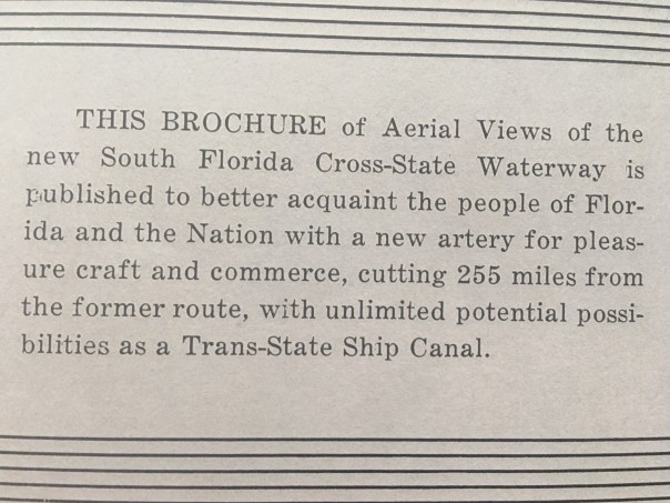
Stuart Daily News, special edition, 1937, courtesy of Knight A. Kiplinger.
The year was 1937 and it was a special day…
The opening of the Stuart, Lake Okeechobee, Ft Meyers, Cross-State Canal…
The first sentence of this historic special edition newspaper reads: “Completion of Florida’s one-and-only cross State canal marks the realization of a dream.”
Yes a dream.
Since the other function of the cross-state canal is drainage of Lake Okeechobee, today many of us associate this cross-state canal with a toxic-algae nightmare more than with a “dream come true.” It’s funny how things change over time…
In any case, this rare document gives perspective and insight and is a tremendous history lesson of South Florida development south of Orlando, along the St Lucie River, Indian River Lagoon, Lake Okeechobee, and our sister city, Ft Meyers.
Thank you to family friend, Mr Knight Kiplinger, (https://www.kiplinger.com/fronts/archive/bios/index.html?bylineID=9)
of Washington D.C and Sewall’s Point, who shared this remarkable document with me. It is an incredible read! So rare! Even my mother, local historian, Sandy Thurlow, had never seen it. And in the following weeks, I will be sharing it with you – transcribing and viewing its 37 giant pages of aerials, ads, and writings.
Today I will begin with the fairly long, but extremely interesting article gracing front and back, written by famed newspaper publisher, and Stuart flowering tree man, Dr. Edwin A. Menninger (https://www.kshs.org/index.php?url=archives/225898).
Enjoy. Think. Regroup. The best is yet to come!
Jacqui
Completion of Florida’s one and only cross state canal marks the realization of dream. The idea of such a channel to link three great natural waterways ~ the St. Lucie River on the East Coast, the vast expanse of Lake Okeechobee (or Myakka, as it was known half a century ago), and the sweeping Caloosahatchee on the Gulf coast ~ goes back to the days when white men first settled the south half of the peninsula. But problems that early thinkers never dreamed of, arose to puzzle the empire builders, and the formal dedication in March 1937 of the waterway from Stuart to Fort Myers signalizes in reality the culmination of achievements stretching over almost fifty years.
It was back in the days of Governor Napoleon B. Broward that first steps were taken to reclaim the Everglades. It was in this years that Isham Randolph was called to make the survey that guided the Glades reclamation project of the next quarter century, and although Broward and Randolph are all but forgotten, their two names stand out as the farsighted leader who started what the rest of us are finishing.
Actually, neither Broward nor Randolph ever gave much thought to the possibilities of cross-state navigation. They were interested in controlling a gigantic lake that has no natural outlet to the sea, and by exercising such control through a series of great canals, they hoped to throw open to cultivation the richest farming land in the United States – the muck lands of the Everglades. The dream of those pioneers was rudely shattered by circumstances far beyond their conception or control, and but for the terrible hurricane of 1928 that drowned 3000 hapless residents of the Glades by literally dumping Lake Okeechobee in their laps the Everglades might conceivably have gone back to the Indians.
But it was this same great misfortune of danger and death, that focused national attention of the Everglades, put $20,000,000 of federal government funds into the picture to prevent future disasters, and opened the navigable waterways from Stuart to Fort Myers that is to be formally declared in March. With a flourish, Uncle Sam has completed an 8-foot channel, from 80 to 200 feet wide, across Florida from the Atlantic Ocean to the Gulf of Mexico. Dyke protection of the Everglades, plus water control by new methods, may make possible the solution of the State’s reclamation problem, but that is another story. Certainly the Glades have staged a marvelous comeback since Uncle Sam’s intervention, and new leaders are arriving to carry on the traditions of Conners, Bryant & Greenwood, Dahlberg, Sherman and a thousand others who have dreamed of empire.
Construction of the St Lucie Canal began in 1921 when the fact dawned on the Everglades pioneers that canals through muck lands were useless – they refused to carry water out of the lake. Four of them had been dug, and were utterly worthless. The St Lucie was completed in 1924 and for 13 years has been the only functioning outlet from Lake Okeechobee to the sea.
The Caloosahatchee River was connected to Lake Okeechobee by two linking canals fifteen years ago, but these proved inadequate to discharge water, and the Caloosahatchee itself was so crooked that it held the water back instead of discharging it. Tedious progress was made in boom days by the Everglades Drainage District, tying to open some tiny ghost of a channel into the Gulf outlet, but when taxes ceased to be paid in the first depression years, the efforts collapsed.
In 1930 Congress was induced to cooperate in a flood control program, and it was contemplated that $3,000,000 of federal funds would be spent. Before folks really understood what was happening, the government had tackled the problem, had achieved as much for the cause of navigation as for the cause of flood control, and had spent more than six times the originally contemplated budget.
The end is not yet. Improvement of the harbor facilities at both ends of this gigantic waterway are inevitable corollaries of the farsighted improvement program that has been car-
ried forward to today. Tomorrow’s projects will include the St Lucie inlet (at Stuart) and Fort Myers harbor improvement on far-reaching-scales. This great cross-state waterway that is a reality, not a dream or a blueprint, crosses the East Coast canal at the St Lucie inlet, and this cross-roads is destined to be a focal point in the future development of Florida’s East Coast.
A thousand men have had a part in the promotion of the canal project between Stuart and Fort Myers, over a period of many years. Thousands will cheer next month as this waterway is opened to craft of all kinds drawing up to 6 feet, with a two-day celebration that will carry a watercade from Stuart to Clewiston and then on to Fort Myers.
Yer standing out, head and shoulders above all the others who have given part of their lives to the realization of this waterway dream, stand two great figures in the daily life of South Florida. The “Stuart Daily News” pays tribute of admiration and respect to these two pioneers-
Commodore Stanley Kitching of Stuart.
Honorable W. P. Franklin of Fort Myers.
Those two men symbolize the cross-Florida canal achievement, and today’s special issue of this newspaper is dedicated to them, in recognition of loyal and untiring service to the terminal cities they call home. Hats off to both of you!
Today’s issue of the “Stuart Daily News” presents a panorama of this magnificent waterway, following a geographical sequence from the Atlantic to the Gulf. An airplane photographer has captured for you a series of pictures that starts at Stuart, carries you 150 miles through the Everglades communities, and on to Fort Myers. Such a graphic portrayal to the canal permits the reader to understand what this waterway is, what it means, what it does. Copies of this book go to every member of Congress, to yachtsman everywhere who are interested in this aid to navigation, and to others who see in this canal another great forward step for Florida. And if this book carries to these readers a message of progress, it has served its purpose.
I am particularly indebted to my faithful assistant, Ernest Lyons, and to an understanding photographer, Lowell Hill, for the effectiveness of the edition.


 Although this image below was not in the publication, I wanted to include it because one might drive by and not recognize this recently renovated, now officially registered historic structure in Rio for what it really is, ~a monument to the cross-state canal!