Greetings to my blog readers! Hope your new year is off to a good start.
For me, 2020 started with the Everglades Coalition (EVCO) Conference January 9-11 at South Seas Island Resort in Captiva Island, Florida. The theme for the conference was “All Hands on Deck,” and I would certainly say that the inspirational event achieved such! (https://www.evergladescoalition.org)
As a member of the South Florida Water Management District, (https://www.sfwmd.gov), I was asked by EVCO Co-Chair Mark Perry, to sit on the panel “Lake Okeechobee Management, The Big Water.” Other panelist were: Dr Dale Gawlik, Director and Professor, Environmental Science Program, Florida Atlantic University; Dr Paul Gray, Everglades Science Coordinator Audubon Florida; David E. Hazellief, Okeechobee County Board of County Commissioners; and Col. Andrew Kelly, Jacksonville District Commander, U.S. Army Corps of Engineers.
Thank you to long time River Warrior, Gayle Ryan, for taping and you can find the entire panel video taped on her Facebook page dated January 10, 2:07pm. To say the least, I felt very privilege to sit with such a group. Today, I would like to share my slides and the 13 minute recorded talk below. Thank the Everglades Coalition for the opportunity to share and the SFWMD for helping me prepare.
I am ready. Both of my hands are on deck!
Historic Phytogeography of South Florida with Present Day SFWMD Features Map, 2019
Last Thursday on November 16, the ACOE reported they will reduce the amount of water they are releasing from Lake Okeechobee. The Corp had been releasing at a high rate, on and off, since September 20th. New targets are 2800 cfs east and 6500 cfs west.
Photos below were taken yesterday, 11-19-17 by my husband, Ed Lippisch. We will continue to document the discharges from Lake O, and area canals.
As Thanksgiving approaches, we are thankful the discharges are lessened and that the SFWMD and the public are working hard to plan the EAA Reservoir Senator Negron fought for… We the people of Martin County, will not be satisfied until these discharge stop. The river has its hands full with unfiltered discharges draining agriculture and developed lands from C-23, C-24, C-25 and C-44. All must be addressed.
“And where the river goes, every living creature that swarms will live, and there will be very many fish. For this water goes there that the waters of the sea may become fresh; so everything will live where the river goes…” Ezekiel
St Lucie Inlet, Sailfish Point R, Jupiter Island L, and Sewall’s Point and mainland Stuart in distance.Sewall’s PointManatee PocketHell’ s Gate Sewall’s Point to rightC-23 main SLRConfluence of SLR/IRL at Sewall’s Point’s southern tipSewall’s PointIRL looking towards Sewall’s Point and Stuart. Incoming tide pushes plume waters north into IRLsomewhere looking down…
SFWMD canal and basin map. C-44 canal is the canal most southerly in the image and was connected to Lake O in 1923. C-23, C-24 and C-25 were built later in the 50s as part of the Central and South Florida Project that over-drianed South Florida causing many of the water problems we live with today.Atlantic ocean off Jupiter Island, plume water moving south over nearshore reefsIRL near Sailfish Flats where seagrass forests used to flourish housing many fish…Hutchinson Island looking to IRLRoosevelt Bridge SLRC-23 SLR
4th Street/East Ocean Blvd 1957, Stuart, Florida, Arthur Ruhnke. Courtesy archives of historian, Sandra Henderson Thurlow.“See that white strip just below the wetland? That is the extension of Flamingo Drive that skirts the pond behind the old car wash. They just dug a retention pond and conducted the water to it. All of that pineland is covered with condominiums today.” (Cedar Point, Vista Pines, and Kingswood)~ Sandra H. Thurlow
Today we drive over the Indian River Lagoon and St Lucie River surrounded by “civilization,” and forget that once it was once a wetland and pine forest full of wildlife. In the course of a lifetime, these things are long forgotten.
The above 1957 photograph hangs in my brother’s law office. When I visit him, I find myself staring at it for long periods of time. It is one of those rare photos that really puts things into perspective. The road construction through the wetlands, (note it going through the pond, and pine forest) was all taking place around the same time that the “Bridges to the Sea,” from Stuart to Sewall’s Point, and Sewall’s Point to Hutchinson Island, were completed. It’s amazing to see what the landscape once looked like. The road in the photograph, Fourth Street, was renamed “East Ocean Boulevard” in 1960, and is a major thoroughfare to the beaches today.
Jenny, Todd and I 1973, alligator in background.I remember early East Ocean Blvd, although it was already quite changed by the time I was born in 1964. My family lived at 109 Edgewood Drive in Stuart, a short distance away from these wetland ponds under development. I recall Scrub Jays in our back yard and feeding them peanuts. By 1974 the family moved across the river to Sewall’s Point “growing and improving” with the changing landscape.
By 1979, when I was fifteen years old, riding my bike over the bridge to Stuart to work at the Pelican Car Wash, the beautiful wetland pond had been relegated to a retention pond for run off. Over the next two decades, you didn’t see wetlands and ponds anymore, or wildlife, just condominiums, office buildings, and shopping plazas. The state four-laned East Ocean Boulevard and built higher bridges to the ocean too.
Believe it or not, the pond in the aerial is still located behind a gas station that used to be the car wash. It is not even a shadow of its former self. Two days ago, I drove by and noticed that there was an extensive algae bloom in the pond backed up to the parking lot and gas pumps; the water reflecting a sickly shade of green.
I sat there thinking about the long forgotten pond in the middle of East Ocean Boulevard in the photo I love in my brother’s office, wishing the developers had figured out a way to go around the pond. As the shortest distance between two points, over time, is not always a straight line.
East Ocean Blvd 1957, courtesy historian, Sandra Henderson Thurlow
Flamingo and retention pond at Flamingo and East Ocean 2017, once a wetland.Google map of East Ocean Blvd. through what was once wetland and forest, 2017.1940s Dept of Agriculture photographs of Martin County showing wetlands. Courtney Todd Thurlow and UF archives.Overlay 1940 aerials over Google map today, Todd Thurlow.USDA History of Wetland Development in Florida: https://www.nrcs.usda.gov/wps/portal/nrcs/detailfull/fl/newsroom/features/?cid=stelprdb1252222
Courtesy of “Historic Jensen and Eden of Florida’s Indian River,” Sandra Henderson Thurlow
When I was kid growing up in Stuart, I remember seeing a lot of cottages. I loved these structures ~so simple, efficient, and adorable too. I remember cottages at Frances Langford’s Outrigger Resort just north of Sewall’s Point; I remember cottages in Rio along Dixie Highway; and I recall the cottages along Indian River Drive in Jensen at the old Pitchford Camp. Somehow the more run down they were, the cooler they appeared. A reminder of days long past before Martin County developed and we were all brainwashed of the need to build bigger houses and complicate our lives.
Today, when one hears the name “Pitchford,” one may envision a Martin County Commission embroiled in a decade of controversy, but this wasn’t always the case. In fact in the early 1900s the name “Pitchford” was a family name that defined “good times” of fishing, dancing, and playing shuffle board along the beautiful and healthy Indian River Lagoon.
Recently, I was invited by long time friend of my parents, Boo Lowery, to see his modern-day, old-fashioned, fish camp. Boo, himself, an “old-timer” is related to many of the early families of the Stuart area. Boo’s career as a respected contractor working closely with famed architect, Peter Jefferson, allowed him to become an expert in building, moving, and renovating homes.
In the 1980s when the cottages at Pitchford Camp were going to be demolished, Boo, who along with his wife Soo is a “lover of all things vintage” stepped in and saved five of the Pitchford Camp cottages. Over time, the little structures have been moved alongside land where a “borrow pit” (dug to build part of I-95) was located. This hole in the ground, today, is a serene pond in the middle of a pine forest, and a living museum housing the Pitchford cottages and of a way of life along our waterways that no longer exists.
It was so much fun going to Boo and Soo’s and today I am sharing some of my photos. While eating hush puppies and alligator, I told my husband, Ed, “I could live in one these cottages.” That I wanted to live in one of these cottages! He looked at me like I was out of my mind… Perhaps, he thinks I’m too soft and spoiled by “progress.” Maybe I’m dreaming, but I think I’d love it. I think I’d be as “happy as a clam…”
In any case, enjoy the photos of this very special place and thank you Boo and Soo for holding on to the old ways and for keeping our Indian River Lagoon history alive.
“Robert McClinton, “Doc, ” Pitchford was the only remaining Pitchford brother after Herbert’s death in 1988. When Doc died in December 2001, it was the end of an era. Doc tried to hold on to the old ways and was quite successful. The Pitchford holdings were like a time capsule surrounded by computer-age progress. Although most of the original Pitchford Camp cabins were demolished….”
Boo saved a few!
(Excerpt and photo below from my mother, Sandra Henderson Thurlow’s book “Historic Eden and Jensen on Florida’s Indian River.”
St Lucie River/Indian River Lagoon, Martin County, FL (JTL)Port of Miami, Biscayne Bay, Miami, FL (JTL)
Today my husband, Ed, is going to take you on a flight south along the Atlantic Coast from the St Lucie River/Indian River Lagoon in Martin County, to the Port of Miami. As we know, the coastline becomes more and more developed as one flies further south. Bright blue skylines of houses and condos morph into shadowy silver skyscrapers, and cargo ships. Expansive greenery slowly disappears…
I, probably like you, know people who grew up in Miami, Ft. Lauderdale, or Palm Beach County who have moved to Martin County to get away from the over-development and traffic nightmare of “down south.” Many tell stories about things changing “overnight,” and no longer recognizing the place they called home.
The “Martin County Difference,” its slow development, is not by accident. Many throughout the years have fought to keep our area less traversed than the rest of South Florida. One thing is for sure, if you want to keep it, you have to fight for it, or otherwise it will be going, going, GONE…
Ed’s tour-view, from the air, really makes the comparison hit home.
(Please see map of cities passed in flight, and 28 photos or slide show below.)
Ed your pilot and tour guideCoastal flight from Stuart/Palm City/Hobe Sound in Martin County to Miami and Key Biscayne.
This slideshow requires JavaScript.
I am having technical problems with this post; long up-loading and off links. I do apologize and will get worked out. Jacqui
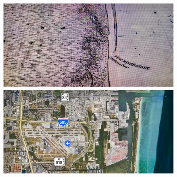
Comparison of 1883 historic map and Google Earth image 2017, Ft Lauderdale’s New River Inlet
Today I am sharing two creations of my brother, Todd Thurlow. Entitled “Ft Lauderdale House of Refuge/Life Saving Station,” and “Short Version,”they were originally for my mother, Sandra Henderson Thurlow and Timothy Dring’s “Image of America, U.S. Life Savings Service” book presentation at the Elliott Museum.
For me, Todd’s videos are mind-boggling as they bear witness to how much and how fast we humans can change the environment. Like an army of ants, we organize; we build; we destroy; we create…
By comparing and contrasting Google Earth maps of today with historic maps from 1883, 1887, and 1935, Todd’s “time capsule flight,” takes us through time and space to see the shifting sands of the multiple New River Inlets; Lake Mabel that morphed into Port Everglades; remnants of the forgotten Middle River that spread and contracted into new canals and developments; and of course, for mom, House of Refuge #4, that once rested north of a New River Inlet that today we can see is completely filled in, while beach-goers relax in reclining chairs like nothing ever happened!
Maybe one day we humans can use all this energy and ability to really fix our waters that have been destroyed during all this construction? Wouldn’t that be a dramatic video?
In closing, in the early 1900s, the New River… that was believed by the Seminoles to once be an underground river that collapsed and the Great Spirit revealed during an earthquake… was selected by modern-day humans as the “natural channel” to connect two of the largest drainage canals from Lake Okeechobee to the Atlantic Coast, the North New River/South New River, and the Miami.
Today I am sharing photos taken yesterday, 2-8-17, by my husband, Ed, over Langford’s Landing, the controversial development along the once high bluff of the St Lucie River located on the northwest border of Sewall’s Point in Rio. Of course this property was the long time home of philanthropist, singer, and movie star, Frances Langford and years after her death, as she wished, those handling her estate put the monies from the sale of this land towards the trust in her name and legacy of giving. Whether the nature-loving long time Martin County resident would have approved of the conditions of the sale, we can only speculate…I know what I think.
Even though the naked property remains visible from the bridges it is nice to see it close up. Thank you Ed for the photos!
As we can see, since December of 2015, all trees have been wiped out, the marina appears completed, the roads are in, the once historic high bluff is now flat and even, and few blades of grass are now visible.
Flying over the black gold of the EAA. JTLFields in Pahokee, JTL
Road Trip Series.
Since I began my Glades “Road Trip” Series, I have read three books by Lake Okeechobee historian, Laurence E. Will: Okeechobee Hurricane, Swamp to Sugar Bowl, and A Cracker History of Okeechobee.
These books hold amazing stories of the Glades; if Mr. Will hadn’t written, there would be very few first-hand accounts of farming that became a Florida mega-industry just over the first half century of the 1900s. Today, I will transcribe some of his most interesting descriptions of Lake Okeechobee, the magical landscape that was transformed into today’s contoversial Everglades Agricultural Area, for none other than its MUCK.
EAA below Lake Okeechobee. (Public map SFWMD)Photo of pond apples also know to locals as custard apples in Big Cypress- shared on Flicker by photographer Mac Stone, allow us to envision what this incredible forest looked like. 32,000 acres rimming the southern and eastern shore of Lake Okeechobee. The best muck built up over thousands of years under these roots that worked like a seine as the lake overflowed its edge then running south through the sawgrass. The Everglades….
pond apples
Close up of small pond apple on Torry Island, by Lawrence E Will.
Florida Memory Project, photo by John Kunkel Small 1869-1938.
Photo from Swamp to Suagrland, showing pond apple with moon vines around Lake O. (Lawrence E Will)
When I was on my recent tour with former mayor of Pahokee, J.P. Sasser, I learned the nick-name for Pahokee is “The Muck,” named so for the “black gold” soil that accumulated over thousands of years under the roots of a custard apple forest that rimmed the lake. (Kind of like fresh water mangroves today in the Indian River Lagoon.)
When one drives deeper into the Glades, one finds similar nick-names or “muck mottos,” that have to do with the muck. For instance, Belle Glade’s motto is “Her Soil is Her Fortune;” Clewiston’s is “America’s Sweetest Town,” and South Bay’s refers to its highways, “Crossroads of South Florida,” named so for its intersection of two major roads, East-West State Road 80, and North-South, U.S. Highway 27, roads that get one into the muck, or out of it….
Will first experienced the Lake in the early 1900s as a boy when his father was developing Okeelanta, located about four miles below today’s South Bay. Okeelanta, today a mill location for the Fanjul holdings, was located not in an apple custard forest, but rather in the miles of sawgrass lying south. Although the soil here is excellent, it is different, more peaty and not as “mucky.” Thus the most productive lands lie closer to the lake, deep in the MUCK.
Here is a moving account by Will about the land of muck in “Cracker History of Lake Okeechobee:
“Before the dredges crashed through the custard apple woods to start the first canals, the lake most always stayed high and clear, unbroken except for those islands Kreamer, Torry, and Observation. When I first saw the lake it was still wild. Excusing the trifling settlements at Utopia, Ritta, and Tantie, a score of fishing camps, and the openings to four unfinished canals, it’s swampy shores hadn’t changed since Zachary Taylor found the redskins or probably not since DeSoto anchored in Tampa Bay. It sill was just as the good Lord had fashioned it. The lake was lonely Mack, silent and mysterious as well. But I tell you boy, it was beautiful, and sort of inspiring too.”
Will was absolutely pro development, pro farming/agriculture, but he, like most of the old timers, recognized the tremendous awe-inspiring beauty of the place.
Most all the natural beauty the lakeside shoreline in Martin County, where the FPL Power Plant is today, and north to the town of Okeechobee has also been radically altered as well.
FPL solar plant and “cooling pond” in Martin County looking west towards “Barley Barber Swamp.” This area was once a forest of mostly giant cypress trees and others. JTL
Excerpts by Lawrence E. Will:
“Dense forest ringed the lake around. Along its northern half water oak, maple, cypress, potash, rubber and palmetto trees crowded each other on the lakeshore ridge…the south shore and half way up the eastern side was something else… Here were custard apples, a solid belt of tropical trees, blanketed with a moonvine cover, which stood, two miles or more in width, without break or opening, from near Clewiston’s Sand Point, slap around to Port Mayaca. 32,000 acres of custard apple woods there were, the most of these trees, I wouldn’t doubt, on the whole blamed continent of America.”
“…Although the shores were for the most part black muck, low and flat, there were some fine sandy beaches too. Along the east side for eighteen miles lay beautiful East Beach…”
“Now if Zachary Taylor or Hamilton Disston could return to Okeechobee they would find that farmers have exterminated the custard apple woods. Highways, service stations, super markets and housing projects have replaced the cypress, rubber and maple trees along the ridge. A levee occupies the onetime shore and drainage has lowered by half a dozen feet the water’s elevation. Tractors cultivate the former seining grounds, and unless you as old–and no amount, as some of us, your never heard of town of Tantie, Utopia or Ritta. Civilization has re-made the lake and I’d be the last to say it isn’t better so, but the lakeshore’s one time natural beauty is long gone, and man, wasn’t that old lake a fascinating place.”
Well, to the land of Lake Okeechobee! For all she was, and for all she is. It’s enough to make one exclaim:”What The Muck?!!!”
My recent Glades tour with former Pahokee mayor, JP Sasser, lasted seven hours, and one of the most unexpected things I got to see was Storm Water Treatment Area 3-4. I have read about the STAs, flown over the STAs, and have had many discussions with engineer, Dr Gary Goforth, who is an “Architect of the STAs,” but nothing prepared me for what I felt when I unexpectedly saw an STA from the ground, or the other mystery I’d learn about that day.
So just about when my tour of the Glades was over, JP looked at me and ask: “Do you want to see the where the big reservoir was supposed to be?”
“Yes!” I exclaimed.” The reservoir? Hmmm. I’d heard stories of “the reservoir” but I really didn’t get it. Why didn’t it get finished? And what is it today? And then of course river advocates like me are supporting Senate President Joe Negron’s reservoir. What’s the deal with all these reservoirs? So confusing…
JP stopped the car, his blue eyes dancing: “We’ll have to drive south….”
“Please!” I begged, knowing I may never have this opportunity again.
So JP turned the steering wheel 180 degrees in the middle of all the sugar fields and headed south of Belle Glade on Highway #27– driving right along the historic North New River Canal that I did know something about.
We drove, and we drove, and we drove…through sugar field after sugar field. And then, there it was, to my right, what appeared to be blowing reeds surrounded by shallow sparkling waters, silver and white, reflecting clouds in a blue sky. Birds flew by. It was beautiful. Miles long. My eyes welled up, and I thought about how amazing it was to see water in this place…”It’s like…..the Everglades….”
We drove until we got to the SFWMD’s STA 3-4 entrance gate and I asked JP to pull over so I could get a picture. I was unsure…So to JP, a Glades local, this area has to with “the reservoir,” but here we are at an STA? As I was pondering, we drove further into Broward County and JP pointed out many new-looking pump stations to send water south. I couldn’t stop wondering about “the reservoir.”
When I got home I did some research.
I believe, in short, this is the story. Please chime in if you know more.
After lawsuit/s due to long-standing polluted EAA water impacting southern lands, and after “acts of the Legislature,” in the 1990s a “Settlement Agreement,” was obtained. Thus the state of Florida had to construct 32,000 acres of storm water treatment areas (STAs) in the EAA (Everglades Agricultural Area) to clean water leaving the EAA and going into Water Conservation Areas and Everglades National Park.
By 2000 the first of six had been constructed, and by 2004 the first water ran through. Thus the building of the STAs is associated with the law suits. At the same time, Congress was working legislatively on CERP, the Comprehensive Everglades Restoration Plan. It was approved by Congress in 2000. But it was moving too slowly, so in 2006, Florida’s state legislature approved LOER (Lake Okeechobee and Estuary Recovery Plan) and under Jeb Bush chose 8 projects of CERP to “accelerate.”
One of the “Acceler 8” projects was the A-1 Reservoir. This reservoir was to be located basically right above STA 3-4 and it had three water components, one for agricultural use; one for the environment; and one for people.
Well time moves on and we are now post Jeb Bush, and into Charlie Crist’ governorship who in 2008 announced that the SFWMD would be negotiating with United States Sugar Corporation (USSC) to acquire as much as 187,000 acres of their land for Everglades Restoration! Lots of internal fighting. Environmentalist are excited about historic land acquisition, but many others are irritated that Everglades Restoration (CERP/Acceler 8) will be halted in order to purchase lands. Other sugar companies in the EAA are impacted as they share mills with USSC. US Sugar surprised everyone with this announcement. Not very nice! Some people in the ag industry are furious. Politics. Lawsuits. But such an opportunity!!! The Great Recession hits. The A-1 Reservoir and its 3 components are halted in order to possibly purchase the USSC lands.
Even more lawsuits ensue including one from the Miccosukkee who want the reservoir completed as their lands are being depleted. Time is of the Essence.
The recession gets worse…the USSC land deal falls apart. Fewer lands are purchased. In 2010 Tea Party and “Jobs” Governor Rick Scott comes to power and negotiates with the Federal Government over of a law suit that included creating Numeric Nutrient Criteria for Phosphorus coming out of the EAA. “10 parts per billion” becomes the number. Some feel he sold out, others think it’s good.
In any case….the SFWMD now implements what the District had been planning as things were falling apart and money got tight, not a 3 part deep reservoir but rather a shallow Flow Equalization Basin, or FEB, in the A-1 reservoir lands above STA 3-4.
Thus the “Restoration Strategies,” law suit brought to the table by Rick Scott and State Legislature funded the A-1 Reservoir FEB and has more to come. What is important to note is that the A-1 FEB and the STAs were created to clean EAA sugar/agricultural runoff, due to lawsuits, not to hold, clean, and convey overflow Lake Okeechobee water that is destroying the estuaries…This is different.
And that’s why we environmentalist are talking about “a reservoir” today…a reservoir that would help the estuaries…because we don’t have one.
On the way home, JP and I talked.
He is concerned that Negron’s 60,000 land purchase for a deep water reservoir could take so much land out of sugar production that one of the EAA’s four mills would not have enough cane to process, close, and put people out work. Pahokee cannot afford this…
“This stinks,” I thought to myself. “Do we have to choose?” Why can’t people in the Glades and the Environment flourish? Everything is so confusing around here. This too should not be a mystery…
I noticed after writing this post that I did not report uses of reservoirs correctly thus I am adding this slide on 12-16-16, one day later. This slide shows what the reservoir compartments were proposed for in this 2012 SFWMD presentation slide by Matt Morrison. I had included “people/water supply” and this was incorrect. The entire presentation is linked below title EAA Storage Reservoirs, 2012. JTL
Today we continue our road trip in the Glades atop the Herbert Hoover Dike.
In the short video below you can see my Glades tour-guide, former mayor JP Sasser, driving, –in his hometown of which he knows so much about–Pahokee. On the right lies the city, and on the left is Lake Okeechobee. A precarious position indeed!
Pahokee is actually unusual in that this little town is “high-ground.” According to JP, about 13 feet above ground. This is not the case for most of the Glades.
Interestingly, in the video, JP discusses how the Army Corp recently decided where to strengthen the dike in Pahokee, because if they had extended it out 500 feet as was done along the rest of the eastern shore, the town of Pahokee would have been covered up as it is located right beside the dike.
Lake Okeechobee’s dike and its history are fascinating just as is all our area of the Northern Everglades including the St Lucie River/Indian River Lagoon that in 1923 became the primary exit point for waters that could no longer flow south after the Herbert Hoover Dike was built.
According to historian and Gladesman Lawrence E. Will:
“…following the floods of 1923 and 1924 water stood over farm lands nearly the entire winter. To protect the farms, the state of Florida had then constructed an earthen dike along the whole south shore. It was some five to eight feet above ground level but this dike was never intended to withstand a hurricane.”
Regarding the expansion of the dike, as the “Herbert Hoover,”after the horrific hurricanes of 1926, ’28 and again in again in ’49, Mr. Nathaniel Reed notes in his writing “Lake Okeechobee and the Everglades: “The Corps of Engineers studied the average size of Lake Okeechobee and designed a dike around it…”
Now this is where things get very interesting.
“The average size of the lake….” what’s that?
Now if we look at this slide taken from a 2016, presented by Jeff Sumner, who was at the time Office Chief State and Agricultural Policy, SFWMD, it shows the size of the lake pre-development. One can see it was about once about 1000 square miles in size and today it is 750.
The False Edge of Lake Okeechobee, SFWMDThe checkered fields were once lake bottom. L. E. Will, “Okeechobee Hurricane”L.E. Will Swamp to Sugar Bowl. The Glades area, today’s Everglades Agricultural Area has become one of the most productive agricultural areas in the world…
Of course the size expanded and contracted based on rainfall, but one still gets the point…this lower area was nature’s shoreline, a boggy marsh with rivers leading into a sawgrass “river of grass” bordered by a forest of over 30,000 acres of Custard Apple trees that functioned like mangroves extending up to five miles or more south into what is today’s Belle Glade. As Mr Lawrence Will would have said: “Who wudda thought!” (http://museumoftheglades.org)
Pahokee is in upper right. Map Laurence E WillThe lake once went further south here and there following the rivers to Hwy. 80Land ownership todaySen. Joe Negron’s map for land purchase
Over the Thanksgiving holiday, I completed a book entitled “Okeechobee Hurricane,” by Lawrence E. Will. The book contains old photographs and provides eyewitness accounts of the great storms of both 1926 and 1928. As we have leaned somewhere between 1500 and 3000 people were killed in the 1928 storm alone. A majority are buried in a mass grave that created a graveyard here in Martin County, at Port Mayaca. There were many farming families, but most of the dead were black migrant workers who had no warning of the storm. Mr. Will relays the horrific stories of these pioneer farming families surviving from Kreamer Island, Torry Islands, Chosen, Belle Glade, Pahokee, South Bay, Bean City, Sebring Farm, Ritta, and Okeechobee.
Pahokee does not have its own chapter but is included in Lawrence Will’s rebuttal of a Palm Beach Times article entitled “The Lost Settlement of Pelican Bay, “a settlement lying between Pahokee and Belle Glade where it had been reported 400 people “must be dead, and 250 of them are now unreachable…”among other things, Mr Will argues that many floated in from miles away and were not from the ‘Pelican Bay’ sugar company camp…
I have to say, although I learned a ton, I am glad I am finished with the book. It was difficult to read so many stories of death. That no one has made a full length feature film of this surprises me: the breaking of the state dike; 7-11 foot rising waters; people fearfully clinging to rooftops with children in hand in 150 mile an hour winds; falling over and gasping for breath while trees and houses floated by or pushed one under. Hair caught in the gates of the locks…More than once, Will refers to the breaking of the dike causing a “tidal wave” coming all at once and travelling from Chosen outward to Belle Glade, like a tsunami.
On page 35 he writes:
“The levee, extending along the southern and part way up the eastern shores of the lake, had been constructed between 1923 and 1925 and had been rebuilt where damaged in the blow of 1926. The dike was built to prevent farm lands from being flooded by high lake levels, it was never intended as a protection from hurricanes. Had there been no levee to pile up the water, there would have been no loss of life in either the hurricane on 1926 or 1928. On the other hand, without the protection against flooding of crops it is extremely doubtful that the Glades could have attained its high state of productivity.”
Quite a thought….one to ponder that’s for sure.
Belle Glade 1928, archives of Sandra Henderson Thurlow.Belle Glade 1928, archives of Sandra Henderson Thurlow
Canal Point, the lake town just south of today’s Martin County line, was once an epicenter of life changing activity, a road trip there is no turning back from…
As we learned previously, in 1917, the construction of the West Palm Beach Canal created Canal Point, the town of lumber-man and developer, Mr. Gilbert A Watkins. During this era, planting sugarcane in the rich muck soils surrounding Lake Okeechobee was becoming even more of a rage and the federal and state government helped it take shape.
In 1913, Florida’s Internal Improvement Fund appointed an engineering commission to study the feasibility of draining the Everglades. At this same time, roads were assessed. In 1919 those belonging to Southern Land and Timber Company, Hamilton Disston’s heirs’ lands around Lake Okeechobee–some that became Watkins’—were determined to be “inadequate.” The only east/west road was Jupiter -Indiantown, and that was not enough.
Nationally, it was all the rage to be part of South Florida’s new-found” investment. “Buffalo’s New Yorker, Fingy Connors, was perfect for the job. He’d lost his thumb when he was young, but this didn’t keep him from grasping or getting what he wanted. After a visit to the area celebrating the building of the West Palm Beach Canal, he bought lands in the area of Canal Point and built his road.
Connors’ Highway Toll-Road became an “engineering and development marvel” and all knew it was Fingy’s skill as a big time political boss that got it done. Like the video and biography in this post implies, some saw him as a villain, and others as a hero…
What is for sure, is that although a large section of the road was built from Canal Point north to Okeechobee, it later was extended under the lake and across the state becoming Highway-80, paving the way for the future of the sugar industry and what would evolve into the riches of the Everglades Agricultural Area.
William J. Conners, aka Fingy (1857-1929) was born in the slums of the Old First Ward. Fingy obtained his nick-name because he lost his thumb when he was young. When he was 19, his parents passed and he acquired a small saloon/rooming house on Louisiana St. He then bought a 2nd saloon on Ohio St. With Conners’s flashy, tough personality, he managed to form contracts to supply labor all across the Great Lakes utilizing 1,000s. His men would eat, sleep, drink, and spend their earnings at his saloons. He had sovereignty over the work force for over a decade. Next in life, he became a leading real-estate developer, operated his own paving company and brewing company, poultry farm, and started the early stages of the Courier Express. Conners definitely tested the waters by reducing wages of grain scoopers which caused a strike. This strike caught nation-wide attention, as 8,000,000 bushels of wheat were backed up. After dipping into politics, he came to control 85% of the packaged freight business on the Great Lakes (Great Lakes Transit Corporation). Conners donated a small fortune to Buffalo’s poor. Later in life, Fingy resided in Florida for half of the year. Floridians considered Fingy to be of hero stature.
HISTORIC PHOTOS CIA FLORIDA MEMORY, CONNORS’ HIGHWAY 1920s.
Connors’ Hwy. toll area with non-diked Lake Okeechobee in background ca. 1925. (Florida Memory Project)A car drives along Connors’ Hwy. with Everglades fauna to right. (FMP) Connors’ Hwy and Everglades fauna.
Cistern with Lake O in background.Connors’ Hwy along area of canal or rim canal-here I am uncertain but this photo too is included in the Florida Memory Projects documentation of the Connors’ Hwy.
HISTOROR MARKER TEXT AND PHOTO
*Thank you to my mother for the photos retrieved from Florida Memory and the write up of the historical marker and the video history.
The Fanjul Brothers, Plantation Services Land Report 2012
“Who Owns the Land? Mapping Out Florida’s Water Future.”
Stofin Co. Inc. is #7 on the Treasure Coast Regional Planning Council’s (TCRPC) map of land ownership in the Everglades Agricultural Area, (EAA). These lands lie on the eastern side of the EAA and comprise 7,189 acres. Stofin Co. is affiliated with Fanjul Corporation more widely known to river activist as “Florida Crystals.” As we know, Fanjul Corporation is a large sugar and real estate conglomerate with interest in Florida, the Dominican Republic and soon to be in the brothers’ homeland, Cuba, once again. The family is very influential in all politics and donates extensively to both the Democratic and Republican parties.
We can see by doing just a bit of research that some of the same officers of Fanjul Corporation are also listed in Stofin Co. Inc. such as Erik J. Blomqvist and Luis J. Hernandez.
Looking at our TCRPC map I have colored #7 parcels in orange just as #2 Okeelanta Corp. and #3 New Hope Sugar Co. were. As we learned earlier those too are Fanjul Corp. lands. I have just added a purple dot to differentiate. So far all in ORANGE below is Fanjul holdings.
It is interesting to compare the TCRPC map with the historic maps also below and note the “shape” of the original “river of grass” before it was dammed and destroyed by agricultural development in the EAA. Note how the river veered off to the right, or in an eastly direction. Surveyor, Chappy Young’s map shows the westerly development over the years into the “Everglades’ agreeed boarder” from the east. We have swallowed her up in every direction. She needs to be restored. It only makes sense that some of the overflow water from Lake Okeechobee destroying the St Lucie River/Indian River Lagoon is allowed to go south again. Thank you for reading my blog and for caring about the health of the St Lucie River/Indian River Lagoon and the Florida Evergldes.
Historic map from 1948 book “Lake Okeechobee” written in 1948 by Alfred Jackson and Kathryn Hanna as part of the Rivers of America Series.War map of the Everglades created during the Seminole Wars, 1856.West of the red lines shows the edge of what was once the Everglades in South Florida. Development has crept and continues to creep over this edge. (Photo/map courtesy of Chappy Young,/GCY Surveyors, 2014.)Senator Joe Negron’s proposed aquisition map in the EAA, 2016.
Today’s lesson in my series “Who Owns the Land? Mapping Out the Future of Water,” is #6, SBG Farms Incorporated. SBG Farms owns 8,569 acres of land in the EAA according to the TCRPC map.
I couldn’t figure out what SBG Farms stood for, but a couple of my favorite acronyms from acronym finder (http://www.acronymfinder.com/SBG.html) were: “Super Blue Green”and “Saved By Grace.”
Yes that makes sense…to not have Super Blue Green algae in the St Lucie River/Indian River Lagoon we all must be Saved By Grace….
So who is SBG Farms?
I believe SBG Farms is part of U.S. Sugar Corporation because according to Sunbiz, where once goes to look up registered corporations in the state of Florida, two of their officers are the same as for U.S. Sugar Corporation: president Robert H. Buker Jr. and vice president Malcolm S .Wade Jr. Also the registered address is in Clewiston, Florida, the same location as U.S. Sugar Corporation. As we learned with land owner #1, U.S. Sugar Corporation is the “Granddaddy” of the land owners. “They were in the EAA first.” We must respect and work with this… You can read the company’s history and their leadership from their website here: (http://www.ussugar.com/history/)
So above I have colored in the #6 parcels in the same purple crayon as #1 (USSC) and outlined in green marker so there is a visual difference.
Now for those of you who have been around fighting for the St Lucie River/Indian River Lagoon since 2013, don’t get worked up when you see “Bubba” Wade’s photo, remember in the end, we all can be “SBG.” All of us that is, and we need it! For a better Florida water future we must all be “Saved By Grace,” and maybe, just maybe, we already are…
Senate Presidient Joe Negron’s proposed land acquisition map for water storage –2016/2017 legislative session.
Former Langford Estate, 1-20-16 Photo by Ed Lippisch.
Today I continue documentation of the former Frances Langford Estate, the 53 acres bordering Mount Pisgah and the Town of Sewall’s Point. Mount Pisgah, at 57 feet, is the highest point in the region along the St Lucie River and Indian River Lagoon.
I have written on this topic extensively already. Perhaps, too much. So I’ll keep it short and just say, once again…”There has to be a better way to develop property with such historical significance, and once, such tremendous natural beauty.”
Yes—- this type of development is within the law, but is it within our conscience? What was Martin County and the Commission thinking when they approved this transfer? How can we stop this from happening again? Can we?
Anyway—I did recently visit the site and the “Engineer of Record” assured me the high bluff will not be leveled to allow for more homes as is rumored.
“It is the lot’s majestic view of the water that we want…” he said. Six will face the river. You can see that lots are small compared to Sewall’s Point.
Personally, I think it would have looked even more majestic if some of Mrs Langford’s world-famous tropical vegetation and pond had been left and the lots were not so crammed in.
In conclusion, here are some photos for “the record.”
Thank you to my husband, Ed Lippisch for taking the aerials. All were taken yesterday, January 20th, 2016.
Oh, by the way, when I was leaving I noticed the documents stated that the cleared land had to be “seeded” within 30 days. We’re getting close. The lot was cleared at Christmas. I bet they put in sod. From tropical paradise to sodded conformity. What a loss.
Front of Langford Landing today 1-19-16. (Photo JTL)Langford home stands on barren hill 1-19-16. (Photo JTL)The subdivision Langford Landing. 6 houses will be located on bluff overlooking the St Lucie River. (Documents on site)A 60 boat marina will be put in. The submerged lands went with the property.…..…….….
Frances Langford and Ralph Evenrude photographed before their trademark Tiki Hut and pond, Jensen Beach Estate, 1961. (Photo Arthur Ruhnke with permission of historian Sandra Henderson Thurlow)Frances Langford as young movie star. April 4, 1913 – July 11, 2005
“I am sure the new development will be re-landscaped very beautifully, but it is hard to see the once serene property so desecrated.” –Local historian, Sandra Thurlow, 2016
“Frances Langford,” the name is as beautiful as the woman. She is a legend here in Martin County and much of the world. No one has been more generous, loving, and appreciative towards our community. A true philanthropist, her name graces buildings, parks, and centers from the Indian River Lagoon to Indiantown.
As a singer and movie star, she is best known for “entertaining the troops” during World War II aside Bob Hope. Through her family, young Frances was exposed to Jensen Beach, and later, after the war, came back to create her dream: “Frances Langford’s Polynesian Outrigger Resort.” It sat along the beautiful St Lucie River and Indian River Lagoon just north of Sewall’s Point.
Over time, inspired by her travels, Frances and her husbands created a tropical paradise known far and wide. Cottages, a restaurant, a marina, palm trees, rare foliage, freshwater ponds, peacocks, and even swans graced the property. Famous movie stars often visited. She gave Martin County a reputation and she put it on the map. She made Martin County’s Jensen Beach her permanent home.
Frances chose to build her personal residence near Mount Pisgah, the highest point of the peninsula. Lore has it that pirates and Indians once lived here too, standing on the high bluff looking for passing ships in the ocean. The property is steeped in beauty, history, and mystery. Sadly, in the end, the remaining 53 acre parcel was treated like any other piece of real estate.
After a long wait since the 2008 Great Recession, the property is finally being developed ironically as “Langford Landing.” The manner in which this is being done has taken most us by surprise.
Is it really necessary to remove every beloved palm tree, stately strangler fig, and blade of grass? Surely Frances thought some of her legacy might stand. It has not. The majority of the property has been scraped clean for new development. My sister said it best: “Jacqui, from the water, it looks like the property has been Napalmed.”
There has to be—-a better way.
The Tiki Hut, bridge and pond, Frances feeding her swans. Many fundraisers were held here and many movie starts attended “in the day.” (Arthur Ruhnke courtesy o Sandra Thurlow, 1961)Langford Estate 1961. (Arthur Ruhnke/ST)Langford Estate 1961. (Arthur Ruhnke/ST)View of estate from river by kayaker. This photo was sent to me by a Facebook friend.
Tiki hut in ruins 2016. (Rebecca Fatzinger)Around the pond, palm trees lay in a heap. 2015. (Photo by Rebecca Fatzinger)Today in 2015/16 photo of Langford property by (Rebecca Fatzinger)The grounds 2015/16 (Rebecca Fatzinger)Estate sold for development. (Courtesy Todd Thurlow/Google Earth)From the air–history scraped clean, 1-1-16, Frances Langford’s estate after all foliage has been removed. (Photo Jacqui Thurlow-Lippisch and Ed Lippisch )Langford Estate seen from the St Lucie River, 12-3-16. (Photo by Todd Thurlow)Photo of one of Frances Langford’s peacocks on her estate, 1980s. (A gift to me from her housekeeper 2006.)Young Frances. Public photo.Frances in her later years.
“Isle Addition” far left. March 1966. Peninsula of Sewall’s Point with roads at High Point are also visible. Looking south at confluence of St Lucie River/Indian River Lagoon. (Photo Arthur Ruhnke via Sandra Henderson Thurlow’s book Sewall’s Point.)
Today I am going to share some aerial photographs that showcase development in Sewall’s Point during the 1960s, specifically, Isle Edition and Archipelago. To give reference, I was born in 1964. During this time and before, the bulkheading of spoil islands was fashionable. Due to environmental restrictions that were put into law in the 1970s, development on such a scale is no longer allowed.
Bulkheading is basically when one creates a seawall. In the case of a some of the islands off the Town of Sewall’s Point, they were cleared, bulkheaded, filled with sand, and then developed. In some instances the fill is high enough that these islands are not completely in same flood zones as surrounding areas.
According to my mother’s book, “Sewall’s Point, A History of a Peninsular Community on Florida’s Treasure Coast:”
“High Point’s “Isle Addition” was developed by Bessemer in 1966, during the same years Perry Boswell developed Archipelago. Both subdivisions are on bulkheaded islands that were augmented by dredge-and-fill operations. Since laws no longer allow this type of development, there will never be another one on Sewall’s Point.” -Sandra Henderson Thurlow
Looking north. This aerial photograph taken in 1960 shows the spoil islands which were to become Isle Addition and Archipelago. Archipelago is further north. (Dillion Reynolds Aerial Photography via Sandra Henderson Thurlow’s book Sewall’s Point.)
The islands I am referring to are spoil islands. They are not natural islands. These islands were created by the ACOE. The 156 mile long Indian River Lagoon has 137 spoil islands; they were formed from 1953 to 1961 when the U.S. Army Corps of Engineers dredged the Intracoastal Waterway — the main channel through the center of the lagoon. The Corps left behind heaps of sand on either side of the channel.
Archipelago first developed in 1964. Photo courtesy of Sandra Henderson Thurlow.
I am including this video my brother Todd created about the spoil islands from an earlier blog as it is most fascinating as is the coast history of our St Lucie River/Indian River Lagoon region. Enjoy!
Historic map with beginnings of Google overlay showing pronged area of South Fork, St Lucie River, C-44 canal’s connection, and the many ponds that once spotted the landscape that are now filled with agriculture and development. (1940 US Government aerials shared by Todd Thurlow.)C-44 canal 1940 map with beginnings of Google overlay emerging. (Todd Thurlow)
0:34 – Roosevelt Bridge 0:39 – Note the Old 1934 two-lane drawbridge in use. The current drawbridge was built in 1964 1:05 – Palm City Bridge 1:22 – Indian Street Bridge 1:27 – Note the increase in width of the river — in some places from approx 225 feet to 460+ feet. 3:24 – Halpatiokee Park 3:24 – Note the old Gaines Highway “Humpback” Bridge (SR-76) in use in 1940. 3:42 – Okeechobee Waterway (C-44) 4:00 – St. Lucie Lock and Dam (—timetable from Todd Thurlow)
I continue to take great pleasure in featuring the “time-capsule flight” historic map and Google Earth work of my brother, Todd Thurlow.(http://thurlowpa.com)
Today’s short video focuses on our beloved South Fork area of the St Lucie River. This video visually juxtaposes 1940s U.S. Government maps to Google Earth images of today. The video begins over an undeveloped Horseshoe Point, Sewall’s Point, and St Lucie River proper and then travels in a southern direction to the wide fork of the St Lucie River and deep along its wild, winding, and African-looking curves. One sees the old Palm City and new Veteran’s Memorial bridges come and go, and notices the build up over time of sand in the fork (maybe some from dredging and some from sediment build-up from Lake Okeechobee releases.) This serpentine and beautiful section of the South Fork is southerly of Highway 76 that runs out to Lake Okeechobee alone the C-44 canal. Today’s I-95 exchange is also visible.
Broad overlay of maps South Fork. (Todd Thurlow)
And the little ponds! My favorite! Just everywhere!This is most incredible to me as today they are “gone.” These hundreds, if not thousands of little ponds, once slowly increased and decreased in depth and size based on rainfall, overflowing at times, into the winding South Fork. One can still see the lush vegetation surrounding some of these areas. Can you imaging the wildlife that used to be in our area? I so would have loved to have seen it but this trip is better than nothing!
As the flight continues, “today’s” development is neatly stacked right up to the winding edge of the fork on the south side in particular…makes me think of septic tanks???
I have to say it nice that there is some land around the areas of the fork and I am sure local environmentalist have fought to keep this over the years. Nonetheless, if we had it to do over again, I think we would decide to leave a much wider birth around these important watersheds.
In the final minutes of the video we travel over the dreaded C-44 canal built in the 1920s, known in its early years as the “St Lucie Canal.” This canal of course, connects Lake Okeechobee to a section of a second prong (fork) in the winding South Fork. The canal itself is wider and apparently the “connection is just “above” today’s Four Rivers which lies beyond the I-95 bridge and exchange and All American Marina.
Zooming in and out in time and place, one can see the cleared lands around St Lucie Locks and Dam and white sand piled high from dredging on the north side of the canal….The picture fades in and out as we view the old locks structure compared to its “new and improved” version today….
I just love this stuff. It makes it all so easy to “see.”
The environmental destruction that is…I guess for others it is the sight of money and making a swamp “useful.” How ever you view it, the journey is an education.
Thank you to Todd for opening my eyes and for allowing me to travel in time and “place.”
C-44 canal Google Earth with St Lucie Locks and Dam. (Todd Thurlow Google Earth)1940 US Gov’t map showing C-44 canal cut from Todd Thurlow’s video. Notice agriculture fields on top of what was a stream.
_______________________________
To see more of Todd’s work on my blog, search his name on my blog’s front page, go to my blog’s “About Jacqui Thurlow-Lippisch” page or just google Todd Thurlow bluewatertt3 on You Tube.
Topographical 1823 U.S. Army map, courtesy of Todd Thurlow.Map in transition/overlay showing today’s I-95 and Turnpike in yellow. (Todd Thurlow)
Link to short video journey showing the former swamp “Alpatiokee” juxtaposed to today’s agriculture and development– Post St Lucie and western Martin County,
The first map in the video is a 1823 U.S. Army Map showing “Al-pa-ti-o-kee Swamp,” as it was known. The second is a 1846 map by Bruff. We then fly in to view Green Ridge, and the ridge just east of Indiantown. Next, we then overlay the 1983 Topo maps to view Green Ridge again, fly up, and around, Ten-mile Creek, and then back down the North Fork of the St. Lucie River. —-Todd Thurlow
Not only was the city of Port St Lucie a swamp, but western Martin County was too. Please view the above video and “see” for yourself! It must have been a fabulous place, now long gone, know as “Alpatiokee,” or “Halpatiokee Swamp.”
Meaning “alligator waters” by the Seminoles, these lands/waterways were traversed for centuries in hand-made canoes. The native people and the Seminoles traveled many miles through the St Lucie River/Indian River Lagoon, and during rainy season they could travel all the way up into the St Johns River. How? Because these lands, when flooded, were “connected.” Now they are not only no longer connected but water that flowed north into the St John’s flows south into the St Lucie River….
Back to Port St Lucie…..
Recently, I kept noticing that the 1856 “Everglades” Military Map I like so much showed an expansive swamp close to where Port St Lucie and western Martin County are located today.
“This is weird,” I thought. “What happened to the old swamp?”
So, I contacted my brother, Todd, who loves maps and can combine them together with technology. (See link/video above.)
Below you’ll find an edited version of Todd’s notes to me.
I find all of this absolutely fascinating, and sometimes a bit unsettling….The natural ridges in the land we seem to ignore; how we blew canals through them; how the water USED to flow; how humans have developed and built agricultural empires, and changed everything….Maybe one day with visual tools like these, future land planners, and water district employees can change back some of our landscape to it’s former glory, and maybe even return a few gators to the landscape, since it’s named after them.
That would be nice, something more to look at while driving the Turnpike than “concrete.” 🙂
Halpatiokee or Alpatiokee translates as “alligator water” in the Seminole language. (Public photo.)
———————-
TODD’S NOTES REGARDING VIDEO:
THE OLD MAPS: The old maps are not necessarily accurate, but they give an idea… They show basically what was known as the “Hal-pa-ti-o-kee Swamp.” On some other maps it is labeled the “Al-pa-ti-o-kee Swamp.” On almost all old maps, it would cover the area that is labeled Allapattah Flats on the modern topographical maps — but Hal-pa-ti-o-kee was probably more to the east.
———————-
Google Earth image 2015, Todd Thurlow.
TOPOGRAPHY AND RIDGES: There are two distinct ridges in western Martin County. Green Ridge is about 4.6 miles west of the turnpike, (12.5 miles west of the ocean), and can be seen on aerials. The western edge of Allapattah flats is a ridge where the elevation goes quickly from about 30 fee to 40 feet. This ridge (an obvious ancient ocean shoreline) can be seen running all the way to Cape Canaveral parallel to the coast. This ridge is about 12.5 miles west of the turnpike (20 miles from the ocean). Indiantown sits on the high side of the ridge. This Hal-pa-ti-o-kee Swamp on those old maps would be the we area east of the Indiantown ridge – so it is basically all of western Martin and St. Lucie County.
FORMER WATER FLOW: Probably everything east of the Green Ridge flowed east into the St. Lucie. Everything between the two ridges flowed north to the St. Johns watershed and everything West of the Indiantown ridge (not much) flowed west into Lake Okeechobee via the little creeks on the east bank of the
….Somewhere between the St. Johns and the St. Lucie so everything between the two ridges, but north of that point, went north to the St. Johns River. Everything south would have gotten picked up by Ten-mile creek in the extreme North Fork of the St. Lucie River, which actually flowed north-east before turning back south to the St. Lucie.
CONCLUSION: There are academics that would know this stuff for sure and all the proper names. These ridges are like little continental divides, separating water flows into separate directions like the Rocky Mountains. When they busted all these canals through the ridges they changed the direction of all the water flows from mostly north/south to east/west. But that was the goal — get it to sea level as quickly as possible and drain the swamps…
1940 aerial photo from a US Dept of Agriculture flight over Martin County, Fl. 1940. Stuart, Sewall’s Point, Hutchinson Island and Jensen are easily recognized by air along the St Lucie River/Indian River Lagoon. Many small ponds can be seen darkly colored. (Photo courtesy of UF Smather’s Library collation.)
1964 photo, (left to right) uncle and aunt, Dale and Mary Hudson, and my parents Sandy and Tom Thurlow. Me in lap. (Family album.)
From the time I was a baby until growing up, I remember lots of ponds here in the region of the St Lucie River/Indian River Lagoon. Hundreds of ponds intertwined with scrub lands…
Some of these boggy ponds were right outside my neighborhood in St Lucie Estates, just off of East Ocean Boulevard. It was the 1960s and 70s. Over time, especially in the 80s and 90s, when I had grown up and was off to University of Florida and beyond, these ponds simply dried up and “disappeared.” These lands became shopping centers, an expanded Witham Field, gas stations, schools, golf courses, and more neighborhoods. The same thing happened to the lands out west of town, but they became expanded agricultural lands. At a kid, I didn’t think too much about it. Today it blows my mind.
The aerial at the top of this blog post is from 1940. I was born in 1964. The small dark areas are ponds. When I asked my brother Todd, who is very knowledgeable on these old photos and land use, where all the ponds went, he noted that when our area canals were constructed by the water districts and Army Corp of Engineers, from about 1920 to the 1960s, the canals not only drained the lands, but over time, the water table dropped, (the water below the surface of the soil that you don’t see) drying out the many of little ponds, so that these lands could be developed.
Canals in Martin and St Lucie counties, C-23, C-24, C-25 were constructed in the 50s and 60s. C-44 is connected to Lake Okeechobee but also drains the agricultural lands around it. It was constructed in the 1920s.
So most of the 1940 wetlands you see in the aerials throughout this blog are now gone, and “we are here.” This happened all over Martin, St Lucie and almost all counties of south Florida. This on top of the shrinkage and drainage of giant Lake Okeechobee!
Yikes!
There is something is really odd about this. Millions of people living in former wetlands. Like sitting atop a dry sponge. No wonder all the wildlife is gone and the rivers are polluted. I’ve heard people talk about this change forever, and I have lived it myself, but seeing my brother’s video below, really bring the whole thing “home.” Watch and wonder where we should go from here…
Click here to see Martin County’s land use change over time, and watch the little ponds/wetlands “disappear. ” Time flight video by Todd Thurlow:
The flight starts in the area around Pratt & Whitney in northern Palm Beach County / southern Martin County where the land still looks like much of Martin County used to look. We then fly to the area around Bridge Road where the headwaters of the South Fork used to be nice and wet in the 1940s. Hundreds of interconnected ponds and bogs eventually coalesced into the tributaries of the South Fork. Today the ponds have been drained for farming and a few neighborhoods. The smallest tributaries are now drainage ditches. Next we fly over the area around the City of Stuart and Witham Field. You can see how the old ponds and bogs lined up between low ridges that run parallel to the ocean. Many of the bogs are now low-lying dry nature preserves in the neighborhoods and golf courses. –Todd Thurlow
1940 DOA image of border between Martin and St Lucie Counties, where Port St Lucie sits today.1940 aerial of east side of east side of Lake Okeechobee and lands of western Martin and St Lucie counties.Ponds and bogs that are still left in undeveloped areas of Martin County. (Photo JTL 2015.)
Map of the 6 Storm Water Treatment Areas south of Lake Okeechobee. (Image courtesy of SFWMD, 2014)
This week, focusing on learning our Everglades-St Lucie/Indian River Lagoon history, we turn our attention to the Storm Water Treatment Areas, better known as “STAs.” These STAs are controversial in two areas that you may have heard about: “Can they hold more Lake Okeechobee water;” and “why does the Everglades Agricultural Area (EAA) get to put their water through them with priority over straight Lake Okeechobee water?” This short write-up will not explore these questions in depth, but rather give an overview of what the STAs are and why they are there.
The Florida’s Everglades Forever Act of 1994 (http://www.floridadep.com/everglades/efa.htm) is the reason the STAs were constructed; the act mandated and funded construction of treatment areas for cleaning phosphorus from stormwater through “recreated wetlands.” The building of the STAs was basically due to a law suit from “downstream” as phosphorus, mostly coming from the Everglades Agricultural Area (EAA), but also from other developed areas, was causing tremendous problem with flora and fauna and wildlife habitat as it flowed into lands south of the lake like the Miccosukee Indian Reservation, as well as Everglades National Park.
Presently, there are six STAs: “STA 1 West and East; STA 2; STA 3/4; and STA 5/6. They are read on a map “backwards” so to speak. You read them right to left, or east to west, like Hebrew. Maybe they built them that way…? This threw me off for a while, but now I’m getting it.
Anyway, let’s learn a little more.
STAs or Storm Water Treatment Areas take up phosphorus through aquatic plants. The dirty storm water from agriculture and development must be cleaned before it reaches the Everglades. (Image SFWMD, 2014)
The building of the STAs has been a huge success story and our own Martin County resident, Dr Gary Goforth, (http://garygoforth.net) worked intimately them when he worked at the SFWMD.
At present, 57,000 acres of land south of Lake Okeechobee, most once in the EAA, have been converted to STAs. In 2014 more water was put through the STAs than in years before as the SFWMD has been apparently afraid putting too much water through them would “hurt” them or they would exceed the phosphorus level allowed to go into the Everglades by a “consent decree.” Dr Goforth had encouraged using the STAs to their full capacity, and so far, from what I hear, the STAs are doing well, maybe even better being fully utilized.
According to the ACOE Periodic Scientist Calls I attend, the only STA that does not seem to get used as much is STA 5/6 in Hendry County. Supposedly this has something to do with how hard it is to get water into the STA.
Hmmmmmmm?
Well that’s enough for today! Lots more to talk about though! 🙂
With “my kids” at Pensacola High School, 1993, 9th grade English Class. (Photo courtesy of photography teacher at PHS.)
History shows that “things can change.” This doesn’t mean it will be easy, or perfect, but things can change.
Today is Martin Luther King Day, and as a former middle and high school English teacher, I have read Dr King’s speech “I Have a Dream,” many times together with my students, and each time, my eyes filled with tears at the prospect that these words could one day come true in spite of the pain and difficulty of “getting there.”
This held especially true when I was teaching in Pensacola, in Escambia County, which at the time was one on the very poorest counties in the state of Florida and may still be… I had two classes of “at risk” kids and my observation was basically that many of my students were “locked in the past” in their thought processes often quoting the Civil War and why things were as they were in their world.
Approaching Martin Luther King Day, we would read aloud Dr King’s speech, and I would tell them that although things are bad, they must remember, that years ago, things were worse, and most of all with the power of collective thinking, THINGS COULD CHANGE. And for that to occur, they had to believe it, live it, and be part of that of change.
I also taught my students some hard facts, noting that if they didn’t know their history, they would not have the tools, fire, or respect to create change in their world.
I believe that this lesson applies to river advocacy for the St Lucie/Indian River Lagoon as well. To make our advocacy work, we must know the history of Florida, the the Army Corp of Engineers, the South Florida Water Management District, agriculture, the EAA, development, and ourselves: then we must believe in change for the river, and we must be a part of that change.
Below are statistics of the history of the St Lucie River and releases from Lake Okeechobee, from 1931 to 2013. In 2014 there were no releases. Right now, in 2015, the ACOE has started again.
Thank you, to Dr Gary Goforth (http://garygoforth.net) for providing these numbers and an explanation of how he achieved them. The two columns are: “Estimated Releases to the River” (SLSR/IRL) and “Estimated Flow from Lake O to C-44 Canal.” Both are in acre feet. I use the first column often to compare and understand how much water has helped destroy our estuary over the years; ; I hope it becomes useful to you as well. And may we have a dream that things will get even better.
1931-2013 numbers for release from Lake Okeechobee to the St Lucie River. (Courtesy of Dr Gary Goforth, 2014.)1931-19601961-19951995-2013. (2014 = 0 to SLR)
Below is history and explanation from Dr Goforth:
History:
A state-authority – the Everglades Drainage District – constructed the St. Lucie Canal (later known as C-44) between May 28, 1915 and 1928. During this time they also built a lock and spillway at the Lake end of the canal and a lock and spillway at the present location of S-80. On June 13, 1923, water from Lake Okeechobee began flowing through the canal into the St. Lucie River.
In the 1930s and in the late 1940s the Corps enlarged the St. Lucie Canal, and it was then known as C-44.
In the 1940s the Corps completed S-80 – the St. Lucie Lock and Spillway – at the site of the original lock on the east end of the Canal. Flow data beginning 10/1/1952 for S-80 are reported by SFWMD.
In the 1970s the Corps constructed S-308 – Port Mayaca Lock and Spillway – west of the site of the original lock on the west end of the Canal.
Flow estimates:
I cannot find flow data for Lake releases to the Canal prior to April 1, 1931.
Between April 1, 1931 and September 30, 1952, Lake releases to the C-44 are reported by U.S. Geological Service.
I cannot find flow data for Lake releases to the C-44 between October 1, 1952 and December 31, 1964. However, flow data is available for S-80 beginning 10/1/1952, so I estimated Lake flows to the Canal for this period based on the S-80 flows and the correlation between concurrent observed flows at S-80 and S-308 (1965-2013).
Beginning January 1, 1965, Lake releases to the C-44 are reported by SFWMD.
I’ve also provided estimates of Lake releases to the St. Lucie River.
Lake releases are currently made to the C-44 Canal for two reasons: 1. Irrigation demand for agriculture in the C-44 Basin. This Lake water enters the Canal at S-308 but does not leave the Canal at S-80. 2. Regulatory releases from the Lake to the St. Lucie River.
Historically, some Lake water was sent to the St. Lucie River for perceived beneficial purposes – however today both Mark Perry and Deb Drum insist that Lake releases provide NO beneficial purpose to the River.
To calculate the Lake releases to the St. Lucie River, you need to compare the flow that enters the Canal at S-308 with the flow that passes through S-80. The minimum of the two flows is estimated to be the Lake flow to the River.
As an example, say 1000 gallons entered the Canal from the Lake on Day 1. The same day, no water passed through S-80. So for Day 1, the estimated Lake flow to the River is the minimum of (1000, 0) or 0 gallons.
As another example, say 1000 gallons entered the Canal from the Lake on Day 2. The same day, 500 gallons passed through S-80. So for Day 2, the estimated Lake flow to the River is the minimum of (1000, 500) or 500 gallons.
Using this method, we can estimate Lake flows to the St. Lucie River (Figure 2 and Table 2). Because flows were not available at both S-308 and S-80 for the period 1931-1964, I estimated these flows based on the correlation between concurrent observed flows at S-80 and S-308 during the period 1965-2013. Other folks (SFWMD or Corps) may estimate the flows differently based on different assumptions. —-Dr Gary Goforth
St Lucie Estates, On the Beautiful St Lucie River, Stuart, Florida, 1926 booklet. (St Lucie Estates, Inc.)
In the 1960s, I grew up in St Lucie Estates, Stuart, Florida, the neighborhood just north and south of Kreugar Creek close to the St Lucie River, not too far from Downtown Stuart. Until I was ten, we lived at 109 Edgewood Drive. I loved that little brick house. I had full reign over the neighboring empty lots and could ride my bike on the “black road,” to get to a park, along the river, next to the Granfield’s house. The kids of the neighborhood often met there, and we pretended the gigantic, falling Australian Pine was a ship and we made it into our fort. We traveled across oceans. We fought pirates. It was a wonderful childhood.
As a kid, I had no idea of the long running issues with the St Lucie River/Indian River Lagoon, the canals, and Lake Okeechobee. I just knew I loved the river. I loved that I could escape there. Even when I was in high school, living in Sewall’s Point, I’d steal away and sit under the bridges and “think” in the privacy of the river’s ancient calm.
Today, at half a century, I am still in love with the river, but I view it in a different light. A light of history and destruction. My heart aches because I really don’t know if it can make it against the odds. Now that I am older, I know its complete destruction has been coming for a long time, kind of like a cancer. I am miffed that since 1923, when the ACOE first connected the C-44 to the South Fork of the St Luice, that locals were not able to stop the “drainage machine,” as Ernie Lyons, previous editor of the Stuart News, called it. I am miffed also that the state and federal agencies would so blatantly kill an ecosystem.
When I look through my mother’s historical data and read the ads for selling land in Stuart in the early 1900s, it is ironic that they all incorporate the St Lucie River into their sell while they were killing her.
“Stuart on the St Lucie, 1907;” “St Luice Estates, On the Beautiful St Lucie River, 1926;” “Stuart, Atlantic Gateway to the Gulf of Mexico, ca. 1926.”
The are all bragging about draining the Everglades; they are bragging about the digging of the Okeechobee Waterway from Stuart to Ft Meyers thorough Lake Okeechobee; they are basing the draw of the Stuart area on its location/proximity to the St Lucie River/Indian River Lagoon, and yet they seem to have no clue that by supporting the over draining and over dredging of everything, they have created the rivers’ own destruction!
All news ads and photos from Stuart on the St Lucie, by Sandra Henderson Thurlow, 2001)
;
This is an excerpt from the St Lucie Estates sales booklet:
” St Lucie Estates is situated in one of the most gorgeous spots in Florida—the beautiful St Lucie River County…The St Lucie and the Indian River meet here to form one of the most wonderful bodies of water in the world—one hundred miles of navigable waterway, edged with luxurious tropical foliage able white sandy beaches…”
“In the introduction to my mother’s book, Stuart on the St Lucie, she writes” Pioneer businessmen of Stuart…realized the St Lucie River was the town’s greatest asset. To foster awareness they of the town’s superior location, they used “Stuart on the St Lucie” in promotional literature, on signs and as newspaper headings. Time has not changed the fact that the St Lucie River is the best thing about Stuart.”
Promotional signs to “Stuart on the St Lucie” along Dixie Highway from Jacksonville read as shown on list and stated, ca. 1919. (SHT).
The St Lucie is still the best thing about Stuart, and now we know better. The drainage of lands surrounding the St Lucie/IRL was too extensive. In order to make way for agriculture and real estate development. The St Lucie River and Indian River Lagoon now take on more than twice what was originally drained into them.
The excess fresh water and pollutants have all but killed the St Lucie River/Indian River Lagoon. This chart shows the original drainage in green and today’s drainage which has been added to the green area in yellow. Lake Okeechobee’s discharges, in pink, are often on top of this. It is too much.
The old adage says “history repeats itself.” Well, here in “Stuart on the St Lucie,” history cannot repeat itself anymore. We must create a new future.
Drainage changes to the SLR 1900s to today.(Citizen’s Report to Congress, 1995)
This aerial photograph is from Sandra Henderson Thurlow’s book, “Sewall’s Point, the History of a Peninsular Community on Florida’s Treasure Coast.” The photo was taken by Dillon-Reynolds Aerial Photography in 1968, ten years after the “bridges to the sea” were built to aid in transportation and development of the area.
Imagine yourself a developer in Florida’s early days along the St Lucie River/Indian River Lagoon. Land is cheap, people are coming, you can dredge and fill, you can create a marina, or bulkhead spoil islands filling and building on top of them, you can cut canals into the land creating more waterfront, and while you are smoking your cigar, you see the peninsula of Sewall’s Point. “Location! Magnificent! A perfect place for a series of hotels right at the tip of the lush pennisula surrounded by water…this would be, simply marvelous!” “Chi-$-Ching!”
Believe it or not, in 1957-1970 that scenario was very much the fate of the Sewall’s Point and the two islands off its tip. The 1957 zoning map, the year the town was incorporated, designated High Point, and the two islands at the southern tip of the peninsula as a “Business-2 Zoning District.” This zoning designation permitted “hotels with not less than 25 rooms, clubs, multiple apartments, and municipal buildings.” (Historic legal documents referenced in Sewall’ s Point, Sandra Henderson Thurlow).
Sewall’s Point zoning map 1957 shows the tip of High Point and two islands zoned for “business.” (Map, Sewall’s Point, Sandra Henderson Thurlow)
So why did not this developer’s dream come true?
“In 1970, a proposal to build multi-family dwellings on Sewall’s Point fell through when the members of the High Point Homeowners Association, working through the town government, defeated the the plan of Bessemer Properties.” (Thurlow) This was a feat, in that Bessemer was controlled by the Phipps family with wealth from steel manufacturing; they were very powerful.
In 1970, after the confrontation, the town’s zoning map was changed to permit only R-1 residential zoning.
So, if you ever feel discouraged about the state of the Indian River Lagoon or other things, think of the story of Sewall’s Point, and remember, a small group of determined people can certainly change their world!
Aerial of Sewall’ Point, 1960 by Dillon-Reynolds Photography, showing new roads in Bessemer’s High Point sub-division.
Muck from the St Lucie River, Indian River Lagoon. (Photo credit, Bob Voisinet, Rivers Coalition, 2006)
It has been described as “black mayonnaise,” and if you’ve ever stepped into parts of the St Lucie River or Indian River Lagoon it may have sucked you down, like quicksand. Muck is as deep as 12 feet or more in some areas and is one of the primary reasons that the St Lucie River, part of the Indian River Lagoon, was declared “impaired” by the state of Florida in the early 2000s.
According to the the Department of Environmental Protection, due to the area’s development, agricultural industry and the building and discharge from canals and Lake Okeechobee, muck sediments into the the St Lucie River have increased causing thick deposits to accumulate.
These muck sediments are contaminated with pesticides, and metals that “may be toxic to indigenous species.” The turbidity and algal blooms the muck sediments support have contributed to the near elimination of once abundant seagrasses, decimation of oysters and outbreaks in fish abnormalities. http://www.dep.state.fl.us/southeast/ecosum/ecosums/SLE_Impairment_Narrative_ver_3.7.pdf
In 2004, with the help of then Senate President, Ken Pruitt, Kevin Henderson of the St Lucie River Initiative, published a study for the SFWMD entitled “Final Report: Characterization, Sources, Beneficial Re-Use, and Removal of Marine Muck Sediments in the St Lucie Estuary.”
This extensive and excellent report concluded that there really are no “beneficial uses” for muck. Because of its high salt content it cannot be used as fertilizer and the cost of transporting it is often “cost prohibitive.” Nonetheless, based of this study the county and district were able to coordinate the plans or execution of muck removal from area creeks, such as Poppleton, Kruegar, Frazier and Haney.
For those of you really into this, it is worth noting that slow moving government policies such as SWIM, Surface Water and Improvement Management, CERP, Central Everglades Restoration Project as well as the Indian River Lagoon Restoration Plan, also deal with muck sediment removal.
There is hope, manatees came back to Kruegar Creek once it was cleaned and the muck sediments of some of the creeks went to build brims at Witham Airfield and “lined” the land fill. Mr Henderson’s report is a reference for all of us and the basis for future improvements.
Also, right now, in the central lagoon they are very close to getting monies from the state for muck removal in their area due to their area senator, Thad Altman’s involvement on Senator Joe Negron’s “Subcommittee on the Indian River Lagoon and Lake Okeechobee.”
As depressing as the river situation is, in the 1970s laws were created to halt destruction of submerged and coastal lands, like here in Sewall’s Point where once developers and the local government could just decide to “create a marina or make subdivisions out of mangrove filled spoil islands. It is a slow go, but in some ways we have been, and we are making progress.
I’m about mucked out, but in case you’d like to learn more about muck, this Saturday at 10am in Sewall’s Point, the River Kidz are tie-dying t-shirts with river muck and colors. They named their project: “Get the Muck Out!” Scientists will be speaking; we will be teaching; and we will be screaming GET THE MUCK OUT! Please join us.


 Historic Phytogeography of South Florida with Present Day SFWMD Features Map, 2019