By June 19, 2023, after over four years of dedicated service, I had not been reconfirmed by the Senate or reappointed by the Governor to the Governing Board of the South Florida Water Management District. As usual, I had spoken up and ruffled feathers; this time in my opposition to Senate Bill 2508. I was crushed but proud not to have been intimidated by power, or to have conformed to something less than what I believed in. I left with my soul intact as an outspoken and passionate advocate for the St. Lucie River, for that and for my service I am grateful.
During that difficult time of transition, my mother, as she has done multiple times in my life, provided opportunity and direction. “Jacqui I am going to write a book on the history of Palm City, would you co-author with me?” I was stunned as I knew nothing about Palm City except it was a cow pasture when I was a kid, but I did know something about the St. Lucie Canal and C-23 Canals that have absolutely shaped Palm City. Mom and I have been working for almost a year now and the book, A Pictorial History of Palm City, will be published by the end of 2024. So, I never wrote my book on the history of the St. Lucie Canal, but I was able to participate in something much more valuable, working together and learning from my amazing mother.
About a month ago, I put together this general information pamphlet entitled “100 Year Anniversary of the St. Lucie Canal.” Yes, it has been 100 years!
This light pamphlet is coming in handy, perhaps even more than a book, during this 2024 round of Lake Okeechobee discharges. I know we are all saddened by the continued degradation of our waters. The way I look at it is that environmental issues are cultural issues taking centuries to change. We are and have been part of that change. Never be discouraged when you are on the right side of history!~Copies are available at the Stuart Heritage Museum or just call me at 772-486-3818.
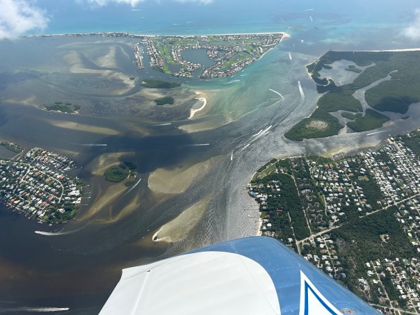
Yesterday, March 4, 2024 around 11:00am, my husband Ed flewCaptain’s for Clean Water videographer Noah Miller over the St. Lucie River and Indian River Lagoon. Noah and his community, on the west coast of South Florida, share in the adversity of Lake Okeechobee discharges. The Caloosahatchee is our sister river and has been for 100 years.
This year heavy discharges to the St. Lucie began February 17, 2024. There was a reprieve for four days, and then the discharges started again on Saturday, March 2nd. Thus these aerials were taken only two days after the estuary had a four day break from her killer. He let her catch her breath, and then it began again…
Today salinity is only 4.4 at the Roosevelt Bridge as documented by my brother Todd’s website eyeonlakeo!
Today, I am sharing some of the photographs that Ed took. There were 92 and I have paired them down; however, in many cases, especially the bare seagrass meadows, I have included multiple shots. I was also struck by the composition of the lands: Sewall’s Point, Hell’s Gate, Hutchinson Island, Stuart, Rocky Point, Jensen, Rio, Palm City, the St. Lucie Inlet State Park and the St. Lucie Inlet. A puzzle sculpted by time. Such a magnificent place! With the marriage of temperate and tropic zones, this area was once considered “the most bio-diverse estuary in North America,” as documented by famous fish scientists like Dr. Grant Gilmore. But over the years, especially since 2013, the St. Lucie has been ravaged by wretchedly dark polluted water from Lake Okeechobee and cyanobacteria known commonly as “toxic algae.”
When things seems hopeless or decades away, what can one do?
Continue to shine the light…
~Noah Miller of Captains for Clean Water takes video as Ed pilots the plane, a Van’s RV. ~Bird Island, below, sits off Sewall’s Point, with over 17 threatened/endangered species. This is nesting time but there is little food to feed the chicks.
Below are ACOE discharge release schedules. Discharges are determined by the U.S. Army Corps of Engineers in consultation with the South Florida Water Management District that acts as the “local sponsor” of the Central and South Florida Project both agencies manage. Years ago, there was little awareness or care about the destruction of the environment, but today we know better. The waste of fresh water into the ocean, the absolute carnage caused to the St. Lucie River/Indian River Lagoon, fish, benthic creatures, oysters, birds, mammals depending on food from it, not to mention the slow death caused to our near shore reefs–today this kind of water management is unacceptable. Try as we may for something better, we are not achieving it fast enough to leave future generations here anything but an empty cornucopia.
It is absolutely beautiful outside. There is not a cloud in the sky, humidity is low, the temperature is perfect, and for all the wading birds and fishes “spring has sprung.” They are excitedly searching for food, but there is little to be found. In the past week, salinity has dropped like a rock and a swift current of filth is pushing towards the St. Luice Inlet.
Boating? Are you kidding? I guess you can, but don’t let your kids swim in the water. Dive the nearshore reefs? I don’t think so!
These aerial photographs were taken just eight days after Lake Okeechobee discharges began into the St. Lucie River. The Army Corps of Engineers with the agreement of their local sponsor, the South Florida Water Management District, endorsed the high level discharges though S-80 to begin on 2-17-24.
Today’s photos were taken yesterday, 2-25-24, around 4pm, by Ed Lippisch and Jay Knobel. I am sharing all photographs for purposes of reference and documentation. The fight goes on as it has for 100 years. Shine the light.
Video
~FOLLOW ON Todd Thurlow’s website eyeonlakeo that now shows SALINITY.
~ACOE’s schedule to be repeated unless changed and reassessed each week. I am also including their announcement given to the people on Valentine’s Day.
Today I share aerial photographs taken by Ed Lippisch on September 17 around 9:30 am to 10am. The great thing about a photograph is that it speaks for itself! We have avoided a recent tropical storm or a hurricane’s impact on Lake Okeechobee, but the lake remains high at 15.41 feet as reported today by the SFWMD. Stormwater and canals C-23, C-24 continue pollute and discolor the estuary. Remember no fertilizer use during rainy season or if you’re like me EVER! Stay vigilant as hurricane season runs from June 1st through November 30th. Your eyes in the sky, J&E
Ed’s comment when he came home from flight yesterday was “not as bad as last time.”
Today’s aerials were taken 8-6-23 around 1:30pm. One can see blue-green algae, along the eastern shoreline of Lake Okeechobee, but not as much in the C-44 canal.
The St. Lucie River looks a bluer near Sewall’s Point- perhaps thanks to recent full moon tides and less rain runoff. Seagrass meadows covered in increasing a cyanobacteria and macro algae are visible. The seagrass is returning, but not in as good a shape, after massive and longterm Lake O discharges in 2018, 2016, and 2013 and decades of destruction.
Sandbar near St. Lucie Inlet, 8-28-23, FB Mike Yustin
Ed and I continue to be your “eye in the sky” and Todd is helping all of us keep an eyeonlakeo now at 15.30 feet according to the SFWMD. Hurricane season should start ramping up. It is not a good situation. More water should be able to be sent south as God intended.
~Lake O, Rim Canal, and C-44 at Port Mayaca’s S-308
~St. Lucie River-Indian River Lagoon. Sewall’s Point divides these waters.
~Note seagrass beds in next two photos. Once 700 acres now much less and impaired. Good to see it in any case!
Thanks Ed!Canal system of CSFP SLR/IRL. credit SFWMD
Northern Lake O algae bloom On Saturday, July 29, 2023, my husband Ed returned from flight with 103 aerial photographs of the St. Lucie River to Lake Okeechobee. When there are so many photographs it is difficult for me to decide which ones to include so I have shared most in gallery format.
The St. Lucie River continues to be darkened by C-23, C-24 and storm water runoff while Lake Okeechobee continues to suffer from cyanobacteria blue-green algae blooms primarily in the north. Ed said there was algae in the middle of the lake but that it was more like a “sheen.” Like gasoline on water.
Ed’s photos show algae on both sides of the St. Luice Canal (C-44), but none at S-80, St. Lucie Locks and Dam, and little visible in the lake -again just a greenish color- at S-308 at Port Mayaca lakeside.
The algae in north Lake Okeechobee is dramatic and looks more clumped than I have witnessed previously. Perhaps wind and rain? Strange…
The only good thing I can say is that the ACOE and SFWMD continue to recommend no discharges from Lake Okeechobee to the St. Lucie River. We’ll see about next week.
On July 25, my brother Todd Thurlow eyeonlakeo texted me that S-308 was open at 1656 cubic feet per second but S-80 remained closed. I would imagine this water let in from the Lake Okeechobee was for canal levels or water supply of agriculture. If I were growing crops I would not wish to accept this water as University of Florida Institute of Food and Agriculture Sciences UF IFAS had notes: “Cyanobacterial toxins can accumulate in crop plants, resulting in injury and yield loss; human health may be affected. Impacts of field crop exposure to cyanotoxins in irrigation water are unknown.”
Known or unknown, it can’t be good.
The historic role of agriculture supported by our state and nation is the primary reason the lake is in such awful condition today; this has been documented since 1969. (U.S. Geological Survey in cooperation with Central and South Florida Flood Control District two year study on chemical and biological conditions of Lake Okeechobee, Beyond the 4th Generation, Lamar Johnson 1974.)
Today I share my husband Ed Lippisch’s aerial photographs and one video taken around 11:30am on 7-23-23. Also included in the post are photos of reemerging seagrass beds taken by my brother Todd Thurlow on 7-2-23. A wonderful thing although Todd estimates that just under 80 acres were in the area he visited.
The St. Luice River/Indian River Lagoon is dark from rain, C-23 and C-24 discharge, and stormwater run-off, however most of the ocean looks gorgeous blue. You can even see the nearshore reefs. Seagrass and or macro-algae appear near the sandbars just inside the inlet. Not the 600 acres of yesteryear but some, and this is a good sign. There has been no discharge of Lake Okeechobee since April and that was a small amount with no algae. Nonetheless, it is never good for the river.
Lake Okeechobee shows no major algae blooms near S-308 as just a week ago at Port Mayaca although one can see the long green wisps like shadows in the water. This changes every day and you can follow at eyeonlakeo. This is Todd’s site and it shows Lake Okeechobee at 15 feet. Pray for no hurricanes.
There is algae on the inside gate of S-308 and some along the St. Lucie Canal also known as the C-44 canal as titled when it became part of the Central and South Florida Flood Control Plan of 1948. S-308 is overseen by the Army Corps of Engineers since 1930 but the South Florida Water Management District is involved spaying peroxide pellets on the algae when it gathers in big blue-green-gray rotting clumps as it did last week. The algae dies but more than likely sinks releasing toxins. A conundrum most definitely….
Thank you to my husband Ed who is in his tenth year documenting our waters by air. All of working together are make a difference. We are watching and they know it.
ACOE documented algae at S-308 on 7-13-23.
TODAY’S AERIALS, 7-23-23 by ED LIPPISCH
Sailfish Flats between Sewall’s Point and Hutchinson Island – note seagrass and macro algae in dark waters.
Seagrass with macro-algae near Sandbar 7-2-23, Todd Thurlow.Hermit crab enjoying seagrass 7-2-23, Todd Thurlow.Underwater one can see the macro-algae atop seagrass. Macro-algae is increasing due to nutrient pollution and warmer temperatures. 7-2-23, Todd Thurlow.St. Lucie Inlet with plume juxtaposed to turquoise Atlantic waters.Roosevelt Bridge at St. Luice River, Stuart (L) and Palm City (R).St. Lucie InletAtlantic sideBlue green algae in St. Luice CanalAttachment to FPL cooling pond – algae presentS-308 Port Mayaca at Lake Okeechobee attached to St. Luice CanalClose up vague algae streaks in lake and in enclosed area locks opening to boat thoroughfare.
Gallery various aerials 7-23-23 EL
Canal systems dumping fresh water into SLR, SFWMD visual of Central and South Florida Flood Control canals of Martin and St. Lucie County.
Date taken: 7-12-23 at 1pm/Location S-308 and C-44 Port Mayaca, Lake Okeechobee, FL/Pilot Ed Lippisch.
Three videos are included of the large cyanobacteria-blue green algae bloom off of S-308. S-308 opens into the C-44 (St. Lucie Canal leading into Stuart and out to St. Lucie Inlet.) This bloom waxes and wanes based on conditions but it “always there.” Nutrient pollution must be overcome.
S-308 is presently closed by ACOE. Keep your eyeonlakeo today measured at 14.87 feet.
These aerials were taken over Port Mayaca and the St Lucie River/Indian River Lagoon by Ed Lippisch on 7-7-23 around 11:30am.
The algae bloom on Lake Okeechobee has lessened compared to two weeks ago however, now Cyanobacteria can be seen clearly on the inside of S-308 at Port Mayaca, Lake Okeechobee. This is from boats coming through the locks from Lake Okeechobee at S-308 as the first two photographs display.
“The blue-green algae continues east along C-44 up to the railroad track, about a quarter to a half mile.” Ed Lippisch.
Keep your eyeonlakeo today, Sunday, 7-9-23 at 14.86 feet.
Gates closed at S-308 algae backed up
Boats going through locks S-308 algae from Lake O enters C-44 aka St Lucie Canal
More photos:
S-80 St Lucie Locks and Dam, about 20 miles east on C-44, no visible algae
Burning field along C-44
C-44 Canal-Turnpike bridge
St Lucie South Fork area where C-44 canal meets Fork of St. Lucie River 1st constructed 1916-1924 by the Everglades Drainage District. Tuned over to ACOE in 1930.
Kiplinger Island at Palm City, St Luice River. Tremendous shoaling occurs here due to St Lucie Canal aka C-44 controversial for 100 years.
7-7-23: St. Lucie River/Indian River Lagoon view from Willoughby Creek approaching Witham Field. River is darker with runoff and canal waters but not Lake Okeechobee. No algae.
SLR/IRL
Most updated chart SFWMD showing inputs for agenda materials 7-7-23. Will be fully updated by 7-13.
“Jacqui, you spoke for the water, for the water had no tongue. And with faux righteousness, Florida’s leaders attacked you. God forbid you call out the bad actors…”
“Bad scene this morning, It’s the whole lake covered.” Toxic Lake Okeechobee. Professional pilot Dave Stone 6-24-23 of Ft. Meyers.
“Lake Okeechobee is really lit up around Pahokee.” Ed Lippisch, 6-23-23.
“The cyanobacteria is now on inside of S-308 Port Mayaca, Lake O.” Ed Lippisch 6-23-23.
S-80 St. Luice Locks and Dam C-44 Canal. Discharge of “basin” waters 6-23-23, but no Lake Okeechobee water.
“St Luice Inlet post rains 6-21-23.” Dr. Scott Kuhns
St. Lucie River dark with runoff, C-23, C24, C-44 but no Lake O.
St. Lucie River dark with runoff and C-23, C24, C-44 but no Lake O.
The condition of this October 23, 1924 Stuart Messenger article makes it difficult to read, but it is important to the history of the St. Luice Canal whose 100 year anniversary is coming up next year in 2024.
In my research, I have noticed the final date of construction of the canal varies in historic documents. Sometimes I see 1925 or 1926. I have chosen to use 1924 because that is the official date used by Florida’s Department of Environmental Protection.
This article entitled “Storm Damage Comparatively Light—Heaviest Rain in Fifty Years,” may shed light on why the completion date of the Everglades Drainage District is hard to pin down.
The bolded line under the headline reads: “Fifteen Inches in Two Days–Trains Stalled for Several Hours–Roads Out North and South–Canal Around Locks–Local Damage Very Light–Wires Kept Open With Few Interruptions.”
Trying to be optimistic, the article begins:
“Stuart is back to normal and is counting up its comparatively small losses after the heaviest rainfall in history. Fifteen inches of rain fell in less that forty-eight hours. Rainfall for the past week has been particularly heavy. On Saturday it rained steadily all day and far into to the night. Sunday’s rainfall was heavy and continuous, all day Monday the downpour continued in to early hours of Tuesday morning…”
~The railroad washed out at Rio…
~The river is the highest within the memory of the oldest inhabitants and backed up over the sea wall both north and south of the county bridge…
~The St Lucie hotel dock went out…
~The river washed away fifteen feet of high ground in front of the hotel annex…
~Reports from the west lock on the St. Lucie canal are to the effect that the canal has cut through around the lock and is digging a wide channel…
~Homes on the South Fork were inundated…
~Water is pouring into the river from the back county in an immense volume. …
The erosion cutting around the lock of the St. Lucie Canal creating a wide channel would have spelled failure for controlling the waters of Lake Okeechobee and surrounding basins. Water pouring in from Allapattah Flats known as the “back county” would have exacerbated an already very dangerous situation.
Lost in time, today we read about an October 23rd, 1924 storm where Stuart, Florida experienced a major rain event ironically occurring right around the time the St. Lucie Canal was being completed or was “complete.” Maybe that is why some articles say the canal was finished in 1925 or 1926 when it was really first completed in 1924? It is important for me to get the date right.
Location: Confluence of the St. Lucie River/Indian River Lagoon; St Lucie Inlet; Roosevelt Bridge; west of Jupiter Narrows; western Martin County lands near Green Ridge and other areas; S-308 Port Mayaca; Palm City SLR area.
Conditions: No discharges from Lake Okeechobee. ACOE stopped April 15, 2013. There have been two major rain events in the past weeks.
Recently I wrote a post entitled: “Learning the Beauty of Pre-Drainage Lands – St Lucie Canal.” One of the most prevalent natural features asked about is “Allapattah Flats.” I recall hearing the mysterious words “Allapattah Flats” while growing up in Martin County. Now, almost 60 years later, I recognize I really do not know what they were…
Page 1, EDD 1915 St Lucie Canal Survey Lake Okeechobee to Okeechobee Atlantic Divide, Florida Archives. Click to enlarge and view Allapattah Flats.
What I mostly heard about as a kid was not “Allapahttah Flats” but “Allapattah Ranch.” Although Allapattah Ranch was a boon in the 1950s, it was part of the total drainage and destruction of this enormous and magnificent swamp documented on many old maps like “Map of the Seat of War in Florida,” compiled by order of Bvt. Brigr. General Z. Taylor in 1839. Through the centuries many words were used for Allapattah Flats -all alluding toalligators like Al-Pa-ti-o-keeSwamp below, or just Halpatiokee. Obviously, there was a lot of fresh water on the land.
Excerpt 1839 Map of the Seat of War, Z.Taylor
In a 1952 Stuart News article shared from Sandra Thurlow’s archives, reporter Ernest Lyons entitles his 1952 news article “Griscom Bettle’s Allapattah Ranch Has 4,000 Acres Under Water Control, Lush Grass on Marin Highway.” Lyons article is a great learning tool. He goes on to explain that 23,000 acres of land was purchased from the Southern States Land and Timer Company around 1947. The land being drained and developed is “six miles deep” along Martin Highway and extends “four miles west from Marin Hammock.” It contains pine ridge land serrated by maiden cane sloughs that “bite” into muck, sand, and clay soils -shells and marl deposits- once an ancient seabed. The lands are so flat -when it rains – the water just spreads out.
Lyons has an easy way to remember Allapattah Flats’ location. It is described as a “long marsh extending down back of Ft. Pierce to the St Lucie Canal.”
There were 2 – 4 feet muck deposits atop marl under 1 – 3 foot of water. The muck is what the landowner is after. He wants to drain and then churn this ancient sea up so soft green grasses can grow on the rich exposed land for cattle.
These thousands of year old “Flats” were separated from the east coast on one side and from Lake Okeechobee on the other. Likely the Green Pine Ridge on the east and the Orlando Ridge on the west. Lyons states the ridges themselves were 8 -12 miles wide!
At this point the article goes into the controversial C-23 canal…
This canal was so controversial. A bad thing for the St. Lucie River. The locals had already had tremendous problems in Bessey Creek and around Palm City with shoaling and fish leaving the area. Now on top of the St. Lucie Canal there would be the C-23 canal. Lyons talks about how the C-23 is being built as an “emergency canal” as part of the Central and South Florida Plan of 1948 post great flood of 1947.
Lyons explains how C-23 starts at the first curve above Bessey Creek Bridge and then cuts through slough depressions again and again between pine ridges. The ACOE is ameliorating the worries of the public by promising “controls” that are to be established every few miles to regulate the water through the Flats.
Bessey Creek and a newly constructed C-23 looking southwest in 1965. Photo archives of Sandra Thurlow.
C-23 was started in 1951 and completed in 1961, nine years after this Stuart News article was written in 1952. What a shame that so much was destroyed and so little saved of the wondrous Allapattah Flats. They really were a part of the Everglades itself. Thankfully somerestoration began in 2014 and continues.
Click on image to enlarge:
Bessey Creek flows into the St Lucie River. Here a newly constructed C-23 photographed in 1965. Allapattah Flats sprawl south and west of canal. The creek is the exiting point for C-23 into the St Lucie River. The canal was built between 1951 and 1961. As land development and farming of the surrounding lands has increased so has the pollution from the canal. (Ruhnke-Photo archives of Sandra Thurlow)
Summary of C-23 written by FDEP in 2000. See map for location of C-23 canal.
*1924 is the 100 year anniversary of the St Lucie Canal AKA C-44. C-23 was built later ’51’-61′ as people continued to drain the area; C-24 ’58-’62; C-25 ’49-62. These dates are from the SFMWD and may include land acquisition.
Full 1839 Z. Taylor map showing pre-drainage lands
Documenting the Discharges – 2023 to St Lucie River/Indian River Lagoon from Lake Okeechobee – 74 days!
Date: Wednesday, April 5, 2023
Time: Around 11 am
Tide: High at Sewall’s Point
Pilot /Photographer: Ed Lippisch
Location: St Lucie River and Indian River Lagoon, St Lucie Inlet, Nearshore Reefs, Atlantic Ocean, Sailfish Flats, Jupiter Narrows, S-80 St Lucie Lock and Dam in St Lucie Canal (C-44), and S-308 at Port Mayaca at Lake Okeechobee
These aerials were taken today, March 22, 2023, around 10:45 am. High tide crested at 11:09 am. Thank you to our eye in the sky and the apple of my eye, Ed Lippisch for consistently photographing the St Lucie River/Indian River Lagoon. Also included is S-308 at Port Mayaca, Lake Okeechobee-checking for algae.
Tomorrow there is a meeting at noon at the St Lucie Locks and Dam of the longstanding defenders of the the river, the Rivers Coalition, asking or one could say, demanding, that the discharges to be stopped. We all know that discharges are helpful for lowing a high (now 14.84) Lake Okeechobee, but not for the health of the St Lucie River/Indian River Lagoon, who has unfairly bore this burden for 99 years.
-St Lucie River/Indian River Lagoon with discharges of 500 cfs. Aerials Ed Lippisch.
Today I share “on the water” visual reporting by my brother, Todd Thurlow. On Saturday, March 18, 2023, Todd and family took a boat ride to the popular Sandbar area just inside the St Lucie Inlet of Martin County. This is a region my husband Ed and I have been documenting since the 500 cubic foot per second discharges from Lake Okeechobee began by the Army Corp of Engineers on January 22, 2023. First there was no algae reported then there was. The ACOE has started and stopped at least three times as reported by TCPalm, but now with the weather cool the gates are again open.
For months, from the air, the historic seagrass beds have looked like a desert.
Todd’s pictures close up, on the water, show some life and give hope that by June or August there may be more lush seagrass meadows as retuned in 2022. Sprigs of seagrass, although light, are visible along with young welch, conch, and moon snails. Wading birds and sea birds can be seen feeding on and around the flats. Rays or manatees take off -hiding in sand cover. Such a beautiful place! This area and its critters are protected; be careful and thoughtful when boating here. It is an Indian River Lagoon aquatic preserve.
Ravaged by discharges from Lake Okeechobee in 2013, 2016, and 2018, the SLR/IRL does not need any Lake O water, this particularly holds true when blue green algae has been reported by the SFWMD, ACOE, FDEP, and the public.
Thank you Todd for this documentation 3-18-23 taken around 11: 50 am.
Thank you for FWC – Florida Wildlife Commission- for creating these IRL Aquatic Preserve signage to help educate and protect seagrasses. Please share! IRL A.P. 18-24 large seagrass_sgn
Todd Thurlow is the author of the website eyeonlakeo.com for “science for the everyday person.”
My husband Ed took these aerials yesterday March 4, 2023 around 11am. He described it as a “mid tide” between high and low. Also swinging by Port Mayaca, at Lake Okeechobee, this time there was no visible algae.
Following Ed’s aerials I am including those of Dr. Scott Kuhns whose photographs taken on February 27, 2023 around 10am showing streaks of algae caused the ACOE to close gate S-308 at Port Mayaca for about 2 1/2 days. Kudos to Dr Kuhns! And thank you to the ACOE for closing!
So the pictures directly below are Ed’s 3-4-23 and those following are Scott’s 2-27-23. We will continue to document the discharges with hopes they will be halted. We all agree that St Lucie River suffers under the discharges. She was taking water to avoid algae in summer. No one thought algae sightings would begin so early in February, but they have. With this discovery, it is time to 🛑 stop! Cyanobacteria is impossible to 100% track and understand. It is too ancient and will outsmart us every time. Close the locks.
IRL/SLR Sewall’s Point to StuartSky River Warriors since 2013. Pilots & friends Dr Ed Lippisch & Dr Scott Kuhns. This photo was taken by JTL in 2016.February 27 by Dr Scott Kuhns. This photo caused the ACOE to close S308 for two and one half days.
~This post is written as part of a series recognizing that 2024 is the official “100 year anniversary” of the infamous St Lucie Canal completed in 1924.
If your’e a history person, or someone who likes to read about the Everglades, you have probably heard the name, “Buckingham Smith.” We learn that the drainage and destruction of the Northern Everglades to drain the Entire Everglades all started with his 1848 reconnoissance and report to the United States Treasury.
Perhaps Smith’s report was the first and major factor, but one can’t read it without noting Smith’s stunning description of the Everglades. Today such words, from someone hellbent on drainage would sound contradictory.
Today, I am transcribing parts of Buckingham Smith’s 1848 report. It was Florida’s Senator, James Westcott who asked the U.S. Department of the Treasury to make this study. Westcott was one of Florida’s first senators when Florida was admitted to the Union in 1845. Smith’s report came out in 1848 and has been reprinted many times. It is world famous. You can access the report partially reprinted in 1911 at the above link.
The link will bring you to Document No. 89 of the U.S. Senates’ 62nd Congress, 1st Session, entitled, Everglades of Florida, Acts, Reports, and Other Papers, State and National, Relating to the Everglades of the State of Florida and their Reclamation, Washington Government Printing Office, 1911. The excepts below are of particular interest from that report.
Transcription page 49, Buckingham Smith Report: (Draining Lake O)
“To reclaim the Everglades and the Atseenahoofa and Halpatiokee Swamps and the lowlands on the margin of the Kissimmee River and its tributaries, and the other rives emptying into Lake Okeechobee, this lake must be tapped by such canals running into the Caloosahatchee on the one side and into the Lochahatchee or San Lucia, or both, on the other, and the cuts must also be made from the streams on both sides of the peninsula into the Glades. Besides, after the height of the waters in the Glades should be decreased, even as much as 5 feet, there will probably be a necessity for several drains through the Glades and those swamps, by which the waters accumulating from the rains may be conducted to the ocean or gulf…”
This excerpt is interesting for me because San Lucia is the St Lucie River. Smith is saying the St Lucie should be tapped or cut to allow Lake Okeechobee to drain to the ocean. This is the first formally government documented statement of such an observation/recommendation. The Halpatiokee Swamp, also mentioned as the headwaters, was located between today’s Martin and St Lucie counties. I am told by my brother Todd that Halpatiokee Swamp and “Alpatiokee Swamp” were used interchangeably. Both meaning “Alligator” in Seminole or some similar language stock. The Loxahatchee river, spelled “Lochahatchee” by Smith, was never connected to drain Lake Okeechobee but has been partially channelized and otherwise extensively drained. The Calooshatchee was tapped first by Hamilton Disston around 1881 to drain Lake Okeechobee and then widened and deepened multiple times as also with the St Lucie. “Asteenahoofa,” a new work for me, was Smith’s word for today’s Big Cypress Swamp.
Transcription page 51, Buckingham Smith Report: (The unusual beauty of the place)
“Imagine a vast lake of fresh water extending in every direction from shore to shore beyond the reach of human vision, ordinarily unruffled by a ripple on its surface, studded with thousands of islands of various sizes, from one-fourth of an acre to hundreds of acres in area, and which are generally covered with dense thickets of shrubbery and vines. Occasionally an island is found with lofty pines and palmettos upon it, but oftener they are without any, and not unusually a solitary majestic palmetto is seen, the only tree upon an island, as if to guide in approaching it, or a place of signal or lookout for its former denizens. The surrounding waters, except in places that at first seem like channel ways (but which are not), are covered with the tall sawgrass, shooting up its straight and slender stem from the shallow bottom of the lake to the height of 10 feet above the surface and covering all but a few rods around from your view. The water is pure and limpid and almost imperceptibly moves, not in partial currents, but in a mass, silently and slowly to the southward. The bottom of the lake at the distance of from 3 to 6 feet is covered with a deposit of decayed vegetable substance, the accumulated product of ages, generally 2 or 3 feet in depth on the white sand and rock that underlies it over the entire surface of the basin. The flexible grass bending gently to the breeze protects the waters from its influence. Lilies and other aquatic flowers of every variety and hue are to be seen on every side, in pleasant contrast with the pale green of the saw grass, and as you draw near an island the beauty of the scene is increased by the rich foliage and blooming flowers of the wild myrtle and the honeysuckle and the shrubs and vines that generally adorn its shores. The profound and wild solitude of the place, the solemn silence that pervades it, unless broken by the splashing of a paddle of the canoe of light bateau with which only can you traverse the Pahayokee, or by the voices of your “compagnons du voyage” add to awakened and excited curiosity feelings bordering on awe. No human being, civilized of savage, inhabits the secluded interior of the Glades. The Seminoles reside in the region between them and the Gulf. Except for the occasional flight of an eagle or a bittern, startled by the strange invaders of their privacy, for for a view of the fishes in the shallow waters gliding swiftly from your boat as it goes near to them your eye would not rest on living thing abiding in this wilderness of “grass waters,” shrubbery, and flowers…”
This page 51 excerpt is interesting because this man who we have forever associated with the determination to drain the Everglades obviously also recognized its awe and beauty. Buckingham Smith was a very learned man of his era, a deep intellectual. I think it pained him in some way to recommend drainage. He had a job to do -survey – and he knew what the government wanted to do. In his full report, he did really present both options: the Everglades’ incredible beautiful essence, and then on the other, hand demonizing it as a filthy swamp to be resurrected for mankind, as below.
Pages 53 and 54: (Smith’s most quoted reference to why the Everglades should be drained)
“Eminent statements and philosophers have, in estimating the services of individuals to their county and to their fellow men, advanced the opinion that he who causes two sheaves of wheat to grow where one only grew before, better deserves the thanks of his race than the author, the legislator, or the victorious general. The degree of merit awarded by them to the particular act first specified may be extravagant, but no one of sound moral judgment will, it is presumed, deny that then increase of the agricultural resources , and the promotion of the the agricultural interests of a people already politically free, is the very highest service that can be rendered them, and most conductive to the preservation of their independence, prosperity, and happiness. The citizen, whether in executive or legislative station, or without either, who succeeds in making fit for cultivation, even if but partially, a region equal in extent to either of the smallest State of this Confederacy, now as useless as the deserts of Africa, will earn a rich meed of praise from the people of Florida and of the Union. The Everglades are now suitable only for the haunt of noxious vermin, or the resort of pestilent reptiles. The statesman whose exertions shall cause the millions of acres they contain, now worse than worthless, to teem with the products of agricultural industry; to be changed into a garden in which can be reared many and various exotics, introduced for the first time for cultivation into the United States, whether necessaries of life, or conveniences, or luxuries merely; that man who thus adds to the resources and wealth and independence of his country, who contributes by such means to the comfort of his fellow men, will merit a high place in public favor, not only with this own generation, but with posterity. He will have created a State. I feel that to be connected with the inception of a measure which, if carried out properly, will probably produce such results; to be identified, even in a secondary position, with the commencement of an undertaking that must be so eminently beneficial to my country, is a privilege of no mean consideration…”
This report has been used thousands of times to showcase the words “The Everglades are now suitable only for the haunt of noxious vermin, or the resort of pestilent reptiles.” A sharp contrast to “Lilies and other aquatic flowers of every variety and hue are to be seen on every side, in pleasant contrast with the pale green of the saw grass, and as you draw near an island the beauty of the scene is increased by the rich foliage and blooming flowers of the wild myrtle and the honeysuckle and the shrubs and vines that generally adorn its shores. The profound and wild solitude of the place, the solemn silence that pervades it, unless broken by the splashing of a paddle of the canoe of light bateau with which only can you traverse the Pahayokee, or by the voices of your “compagnons du voyage” add to awakened and excited curiosity feelings bordering on awe.”
I wonder what Buckingham Smith would write if he were alive today?
These aerial photographs were taken by my husband, Ed Lippisch, on Friday, February 24, 2023 around 1:51 pm during high tide. It was a beautiful day and many boats were fishing over the nearshore reefs. The 500 cubic feet per second discharges are much less noticeable at high tide; the visual loss of seagrass remains. I am sharing all photographs -many are very similar, you can look for small differences.
Please see slides from ACOE Periodic Scientist Call on 2-21-23 for updates on Lake Okeechobee level, red tide on west coast, east coast conditions, and other important information. Periodic_Scientists_Call_2023-02-21
With the hot, dry weather the last few days Lake Okeechobee’s evaporation should be high. Today the SFWMD reported the lake at 15.61 feet. You can see the ecological envelope band in gray below.
Manuscript Collection, Florida Memory, circa 1921.
I invite my readers to attend a presentation entitled “The History of the St. Luice Canal.”Todd Thurlow and I will be using historic maps, newspapers, and photographs together with modern technology to give insight into a canal that has been “on the minds of men” since the mid 1800s and even earlier.
If you want to attend in person, please join us at the Rivers Coalition meeting, Thursday, February 23, at 11:00am, Stuart City Hall Chambers, 121 S.W. Flagler Avenue, Stuart , FL 34994. If you’d like to join via Zoom, please reach out to the the meeting administrator at miki@riverscoalition.org and request a Zoom link.
I hope you’ll join us!
The St. Lucie Canal was built by the Everglades Drainage District from 1915-1924 (some records state 1925 or 1926). Its unnatural connection drains surrounding lands and allows “overflow” water from Lake Okeechobee to be directed to the St. Lucie River wrecking the estuary’s delicate wildlife ecology and spurring massive toxic blooms in 2013, 2016, and 2018. Of course, the canal has been a boon for agriculture and development of all South and Central Florida as it was built as the “primary drainage canal” of the Everglades.
As the official completion date of the St Lucie Canal by the Florida Department of Environmental Protection is 1924, next year will be the 100 Year Anniversary of the St. Lucie Canal. Thus this year, in 2023, I am writing and presenting extensively on the history of this beloved and hated canal as we work to weave it into a better water future.
Lock No. 2, original structure at today’s St Lucie Lock and Dam.
~Ed’s Aerial Report 24 days after discharges begin at 500 cfs via ACOE from Lake Okeechobee to SLR/IRL. Documenting the Discharges.
My husband Ed Lippisch has asked me to get these photos on-line ASAP. They were taken of the St Lucie River/Indian River Lagoon area around Sewall’s Point, yesterday, February 15, 2023 around 1:25pm. It was an incoming tide about two hours after low tide. I do not have time to go through all the photos so I am sharing all of them. Many are almost identical. Color doesn’t look great. No seagrasses visible. Salinity remains in range according to FDEP. See my brother Todd’s website EyeonLakeO.com for more information.
Today’s post is Part 2 of “Palm City, Empire of the Everglades,”written for the upcoming, 2024, official 100 year anniversary of the completion of the St Lucie Canal. This canal was renamed the C-44 Canal after the federal government’s incorporation of the canal into the construction of the Central and Southern Florida Project -post “great flood” of 1947.
I prefer to call C-44 it by its first and more personal name, the St Lucie Canal.
Below is part two of a transcription of an historic 1923 Miami Herald article from my mother Sandra Thurlow’s local Martin County, Florida, history archives. Today’s historic article gives insight into a world forgotten. A world of excitement for “drain baby drain,” with little if any concern or knowledge of the health of Florida’s state waters or the greater environment.
In the few remaining paragraphs of the article the reporter, William Stuart Hill, notes how many miles of ditches have been dug, what dredging contracts have been executed, what equipment will be purchased for even more ditching to drain into the St Lucie River and St Lucie Canal, and what roads are available – by today’s standards very few!
It was a world set out to drain the Everglades and a tremendous determination to create an empire of agriculture. In 1923, there was no Publix at every corner, nor FEMA to come help if a hurricane brought you to your knees and the drainage of the land to produce food became extensive.
Thank you to my mother for sharing these old articles and pointing out the important history of Palm City, Florida. As we learn about our past, we can build a better future.
I am posting this photograph to give an idea of what a drag line machine/excavator look like as referred to in the article as one hoped to use by F.A. McKinzie, via Florida Memory. http://www.floridamemory.com/items/show/105693
The drainage district has recently sold bonds amounting to $100,000 to carry on a more comprehensive plan of drainage than the one originally intended and has awarded a contact to F.A.McKenzie, of Miami, for widening and deepening the original outlets and doing other work. Mr McKenzie’s contract provides for the payment by the drainage district to him of $75,000. Supervisors of the drainage district are: G. Wuckner, F.C Garde and O. Coffrin, all of Palm City. The drainage district was created under the general statutes by petition to the circuit court.
Map of Palm City Drainage District. This map is not from the Miami Herald Article, but from my mother, Sandra Thurlow’s archives. It shows the many ditches dug to drain the land of Palm City Farms in the Palm City Drainage District created in 1919.
Mr. McKenzie is making preparations to begin work immediately on the execution of an Economy drag line excavator, and intends buying a Bucyrus machine.
A hard surface road extension seven miles through the district, and leads from Palm City to Tropical City and thence back to Stuart, a total distance of 21 miles.
The Palm Beach County Land company, at its own expense, dug 40 miles of drainage ditches, exclusive of 80 miles of road ditches, at a cost of $63,720. It also built more than 40 miles of dirt roads in Palm City Farms, on the outer lines of the sections, at an expenditure of $38,783.
Transcription/article end. JTL
Maiami Herald, 1923.
I am including the map below from 1928 (five years after the Miami Herald article) as it shows what roads were in the Palm City area although Palm City is not on the map. Road to the Glades, today’s Highway 76 or Kanner Highway, US 1 -some that was linked with today’s AIA or Dixie Highway, and what was known as “Loop Road” off of 96A (opposite direction of today’s Pratt Whitney Road going to Citrus Blvd.) are visible as is the infamous St Lucie Canal built first from 1916-1924. Again, thank you to my mother for sharing all of these historic documents in my obsession to document the history and thus aid in a better water future for the St Lucie Canal and St Lucie River.
Today I share yet another remarkable historic article from my mother Sandra Thurlow’s archives. This time from the Miami Herald, 1923. The significance of this article, that I have transcribed and broken down into two parts, is that it tells the story of Palm City, Florida, as part of the “Empire of the Everglades;” this a past of Palm City that most of us don’t know.
Indeed, Palm City was founded partially as Palm City Farms and even had its own drainage district. We have altered the land so we can be productive and live here, and today, and in the future, we try the best we can to put some of the water back on the land to clean it and bring all back to health. Also this article is shared as 2024 is the official 100 year anniversary of the St Lucie Canal.
“Empire of the Everglades,” Miami Herald, 1923, Part 1 as transcribed by JTL
~Transcription begin
“The Great Prairie of Florida”
Palm City Drainage District Lets Contract for Additional Ditches
Will Expend $100,000 Supplementing the Original Drainage Plan; 900 Acres of Citrus Trees Growing In the Reclaimed Area; C.C. Chillilngworth Is the Developer.
By William Stuart Hill
Back of Stuart, in the Palm Beach county, lies Palm City, then Palm City Farms and the Palm City Drainage District, the latter extending almost to the St. Lucie canal and containing 14,300 acres of land and prairie.
Palm City is situate on the shore of the south fork of the St. Lucie river, and its inhabitants have access to the other bank by means of the Palm City bridge, and to Stuart two miles away, by means of a hard surface road. Another road, to the south, connects with the Dixie highway at a considerable distance below Stuart.
The Palm City drainage district was formed recently to supplement the work of drainage begun and achieved by the Palm Beach County Land company, original owner and developer of the Palm City Farms, C.C. Chillingworth, attorney, of West Palm Beach, is owner of the Palm Beach County Farms company and retains about 5000 acres of the original 10,000 acre tract. The remainder has been sold to settlers.
There are 28 citrus groves in Palm City Farms, comprising 900 acres. The largest of these, the grove owned by the Niagara Fruit company, contains 160 acres, and is said to be the largest citrus grove on the east coast of Florida. There are also considerable plantings of avocados and one guava grove in the drainage district, which takes in 6,200 acres not in the Palm Beach Farms.
The land within the drainage district is well adapted to citrus culture and has the double advantage of easy drainage and easier irrigation. The highest elevation in the district is 27 feet above sea level. Artesian water may be had, with flowing wells at a depth of approximately 600 feet.
During the years between 1912 and 1916, the land company spent $102,000 in the digging of drainage ditches and the construction of the roads within its 10,000-acre tract. Three main outlets were provided, one through Danforth creek, another through Bessey’s creek, and a third large ditch, emptying into the south fork of the St Lucie river near the outlet of the big St. Lucie Everglades drainage or control canal.
Aerials of St Lucie River/Indian River Lagoon taken February 3, 2023, 1pm “about two hours before low tide.”Florida Oceanographic Society graded the St. Lucie River at an overall “B” for water quality January 26 through February 1st. An “A” for the IRL and a “C” for the SLR west of Sewall’s Point. Since January 22, 2023, the ACOE continues to discharge 500 cubic feet per second from Lake Okeechobee to lower the lake in avoidance of toxic algae blooms predicted in Lake Okeechobee this summer due to Hurricane Ian. The lake is presently at 15.92 feet down from 16.10 feet on January 22, 2023. ~Photographs Ed Lippisch
Ed Lippisch River Warrior documenting the SLR since 2013.
~Aerials below taken 12 days after ACOE began discharging 500 cubic feet per second from S-80 via Lake Okeechobee. Color better in IRL than SLR. Of concern no visible seagrass.
SFWMD’s most recent chart from Environmental Conditions Report: Total Flow to the SLR.
~St Lucie Inlet and Crossroads of SLR/IRL at Sewall’s Point, Stuart, Martin County, FL 2/3/23
Follow Todd Thurlow eyeonlakeo.com for easy to read updates.
SFWMD canal and basin map. C-44 canal is the canal most southerly in the image. When S-308 is open at Port Mayaca, Lake Okeechobee water discharges through the C-44 canal and S-80 into the St Lucie River. This is totally unnatural as the St Lucie was never connected to the lake. The ACOE & SFWMD are working at a record pace to improve the plight of the northern estuaries through a new lake schedule, LOSOM, and CERP-Everglades Restoration.
Due to high Lake Okeechobee level and in light of cyanaobactia blooms predicted on lake this summer -a side effect of Category 4 Hurricane Ian- the U. S. Army Corp of Engineers, with the support of the SFWMD on 1-22-23, began discharging 500 cubic feet per second to the St Lucie River/Indian River Lagoon on January 22, 2023 and 2000 cfs to the Caloosahatchee to lower a lake not receding.
Yesterday, on January 29, 2023 my husband, Ed Lippisch, flew over the St Lucie River to see how the estuary is visually faring after seven days of discharges. He captured the images around 2pm so it was what he calls a “slack tide,” a tide in between high tide and low tide.
Today I share Ed’s aerials, the effects of discharges is obvious and to compare to a pre-discharge high tide and low tide taken on January 22, 2023, before the discharges reached the estuary, please see link above and go to end of blog post.
I cannot thank my husband enough for all of his flights and dedication as a River Warrior of the St Lucie River. He continues to be our eye in the sky since 2013 and my best friend.
Tide chart St Luce River. Note January 29, 2023. Ed’s photos were taken beginning at 1:56pm.
Below:
Aerials of St Lucie River/Indian River Lagoon after 7 days of discharges from Lake O, note darker water and plume at inlet. Among other things, the discharges cause less light to reach the struggling seagrasses and a plume exiting the St Lucie Inlet covers already sick near shore reefs.
More CERP projects than ever before are being built to offset discharges to the estuaries and this is cause for celebration, but it will take years for these projects to all be completed and undo the horrible environmental consequence of the Central and Southern Florida Plan of 1948. Most recently, since 2018, the State of Florida under the DeSantis administration, has led the effort to stop harmful discharges to the estuaries under Executive Order 19-12 and now 23-06. Millions of dollars are being spent by state and federal government. We will get there.
Slide of expenditures, Everglades Coalition Conference 2023 presentation.
LOSOM, a new lake operations schedule of the ACOE, will help too and should be in place by mid summer. This was an effort of all stakeholders. An exhausting and successful effort.
The St Lucie has not had heavy discharges in over four years. At height in years such as 2013, 2016 and 2018, over 5000 to 9000 cubic feet per second were sent to the St Lucie. This present 500 cfs is an attempt to avoid such a situation this summer. To lower the lake before it kills us. I hate discharges but I rather take my medicine now than be destroyed later. Also I appreciate the ACOE for trying something different (HAB DEVIATIONS & LOSOM). I have been watching like a hawk since 2008, I can assure you we are in a better place due to advocacy changing the political landscape. Do not get discouraged!
Lake Okeechobee Lake Levels U.S. ACOE
To follow the most updated lake okeechobee levels go to Todd Thurlow, eyeonlakeo.com
Grey is environmental envelope for Lake O. It is to be seen what the goal is for lowering the lake and decisions will be made weekly by ACOE.
-Stuart News 50th Anniversary Edition, 1964.Today I will complete part three, the final portion of my transcription of an historic 1964 Stuart News, anniversary edition from my mother’s archives. She actually shared this article with me over a year ago and I was so taken by it that I thought it may be an inspiration for a book. I never got around to it, thus now I am sharing on my blog as part of my 2023 new year’s resolution to write more and learn more about the St Lucie Canal. 2024 is the official 100 year anniversary of the St Lucie Canal according to the Department of Environmental Protection.
~Interesting references in part three of the article are the mentioning of a “release canal,” south to the Everglades, something that never materialized; reference, once again, to cutting edge “scientific water control” and the amazing success of the agriculture industry; 1933 noted as the first extreme discharge year from Lake Okeechobee to the St. Lucie River and damaging effects to fisheries and tourism; and in the final paragraph, a future plan linking a new “C-23 Canal on Martin County’s northern border with a major channel which would extend westward to Lake Okeechobee, with a side link to St Lucie Canal, and another channel from St. Lucie Canal southeastward down toward Pratt & Whitney and the Loxahatchee Marshes;” Gulp!
This is a reference to part of the canal system proposed in the 1948 and many following editions of the Central and Southern Florida Plan that thankfully was never built. This reference also leads me to believe that I was incorrect in part two when I wrote the article was written around 1937 or 1920 in part one. With these references to C-23, the article must have been composed after the great flood of 1947 as it is referring to the Central and Southern Florida Project of 1948. I am learning all the time as I sludge through this stuff. The St. Lucie Canal has had so many face lifts! It is hard to know what cut they are referring to!
~As we learn, we are more informed and able to change the future of this huge “ditch” that has defined, benefited, and destroyed the region of our St Lucie River.
So here is a transcription of Part III.
I have entitled my post “The Boon of the Huge Monster Ditch, St Lucie Canal,” as both terms “huge” and “monster,” are noted in full article. To me, the canal is a monster continuing to haunt and terrify. And just like in the movies, I know that until I meet this monster face to face, it wont go away. I hope you will encounter it with me.
You can click on images to enlarge.
Begin transcript paragraphs 11-25:
The great hurricane of 1928, which drowned about 4000 persons in the Lake Okeechobee area, resulted in the widening and deepening of both the St. Luice Canal and the Caloosahatchee River as well as major outlets from the lake. The widened and deepened canal was officially dedicated at ceremonies headed by Secretary of Commerce, Daniel Roper on March 22, 1937.
In the intervening years, the canal’s “good and bad” points have been the cause of growth in the agricultural lands of the interior and of damages to the fisheries and resorts on the coast in periods of excessive discharge. Today, as ever since 1933, when the first heavy discharge from hurricane rains was experienced, efforts are under way to so shape the discharge so that the canal’s benefit can be enjoyed without attendant harm. The U. S. Engineer Corp’s plans for a higher lake level by diking the entire lake may result in less necessity for discharge and a long-range plan has been advanced for diversion of excess water to Everglades National Park by means of a relief-valve canal.
However in the half century which has ensued since the canal was approved, one indisputable fact not clearly seen in the beginning has emerged stage by stage to justify it.
It is “scientific agriculture by water control.”
Thousands of pleasure craft and hundreds of barges, shrimp boats, and other commercial craft use the waterway today, but it never did develop into the “thriving artery of commerce” that was predicted in which ocean ships would sail up to Stuart and load the products of the Everglades Empire brought to the coast by the St. Luice Canal.
Nor did a plan advocated during World War II jell out to make it a major barge and oil transport canal to escape the submarines which infested the Straits of Florida, Yucatan Channel and the Gulf Stream.
What did “jell out” was an expansion all along the route of the the scientific water control for agriculture that was proven at Port Mayaca by that pioneering agricultural beginning in 1925.
G.C. Troup and Troup Brothers at Indiantown on their former 20,000-acre holdings, demonstrated that the combination of irrigation and good drainage would unlock agricultural riches. Today the Minute Maid and Hood corporations are among the huge citrus firms which have planted some 10,000 acres of new citrus and the largest lemon grove in the world on former Troup lands and lands opened to agriculture through water control by P. L. Hinson and others.
On both sides of the St. Lucie Canal, in the entire twenty-five miles of its length, there are spreading pastures, ranches where blooded cattle graze, and the Indiantown area also has some of the country’s largest diaries.
The Bessemer firm that proved it could be done is “in there pitching” with some of the most outstanding modern developments including Westbury Farms 1, 2, and 3, the new Westbury Farms Valencia Groves on the south side of the canal, and the spreading Green Ridge Groves on the north side. George Oliver who manages the giant spread and Michael Phipps of the major corporation are proud of the agricultural and ranching growth but prouder still of St. Lucie Training Park, unique race horse training facility where, “hopefuls” of some of the nation’s top stables get their “running” starts.
They can be found at dawn watching the work-outs on the oval track. Both are skilled polo players.
“Scientific water control with ample supplies from the St. Lucie Canal, and drainage into the canal, is the key to our county’s solid growth,” commented Oliver.
Currently being pushed by Martin County agricultural interests is a new over-all water control plan for the county which would spread the advantages of irrigation and drainage to areas not continuous to the St Lucie Canal.
The new plan would link in C-23 Canal on Martin County’s north border, where huge citrus planting have recently been made, with a major channel which would extend westward to Lake Okeechobee, with a side link to St Lucie Canal, and another channel from St. Lucie Canal southeastward down toward Pratt & Whitney and the Loxahatchee Marshes. Private landowners would link in with these new canals by irrigation pumps and drainage outlet as they have done along the St. Luice Canal.
-Eye in the sky since 2013, Ed Lippisch I am going to keep this blog post short as I already wrote another today. Yesterday, 1-15-23, at around 1:45 pm, Ed took aerials over the St Lucie River/Indian River Lagoon. As it has been cold and windy the past few days there has been a “Beach Hazards Statement” from the National Weather Service. In Ed’s photos, the rough, turquoise, incoming ocean waters make for a stark contrast against the darker waters of the river. I believe the ocean waters are full of sand and that is what gives the aerials the milky, almost iridescent coloring. Hopefully, the sand is not burying the dormant seagrasses in the Sandbar and Sailfish Flats. Thankfully, there is no dumping from Lake Okeechobee at this time although the river is receiving the other C-Canal water and runoff. I’ll get Ed up in the plane again soon as I have not yet flown in the Van’s RV -and I am not planning on it! 🙂 JTL
Today’s post is the second part of a story. A story from the 196450th Anniversary Edition of the Stuart News. “Signalizing Half a Century of Growth and Progress in Martin County,Florida.” It is a huge special edition newspaper, 110 pages!
The article I am sharing is on page 6-H and is titled ” St. Lucie Canal Approved in 1914, Is Boon to Agriculture Here. Huge Citrus Growth Along Water Route; Mayaca Groves First.” I feel this remarkable article given to my mother for her history archives by family friend and real estate man, Ronnie Nelson, must be shared. As the 100 year “anniversary”of the St. Luice Canal is next year in 2024. At this time, I must state I am finding many different dates as to the completion date of the canal, but at this point I am sticking with an article from the Department of Environmental Protection, 1916-1924. (Ecosummary 2001, C-44 Canal)
Learning about the St. Lucie Canal can be confusing because it was “rebuilt” or “improved” and, believe it or not, “celebrated” a few times. I think this article included in the 50th anniversary edition was written as the canal approached its second rebirth in 1937.
There is so much to learn about how the St. Lucie Canal was perceived in earlier times. And it is only through understanding the past, that we can create a better water future for today and for tomorrow.
1964 Stuart News, 50th Anniversary Issue, Thurlow Archives
1964, Stuart News 6-H and 7-H
Transcription begins:
“The completion of this monster ditch will mean much for the Everglades, for south Florida in general, and for Stuart in particular. The improvement of the St. Lucie Inlet and harbor will thus make Stuart the gateway to the Everglades, and millions of dollars worth of agricultural timber, fish, and livestock products will pass through the canal transferring at Stuart onto ocean-going vessels. The canal is, according to contract, to be completed in four years.
First tangible result of the canal for large-scale agriculture was the pioneering effort of the Port Mayaca development back around 1925, created by Bessemer Properties, Inc., a Phipps company which saw the opportunities for agriculture through scientific water control by tapping on to St. Lucie Canal with pumps to provide irrigation in dry spells. At the same time, a series of canals discharged excess water into the canal during wet spells.
Port Mayaca Valencia orange groves today represents the first big-scale successful planting of citrus in Martin County.
Port Mayaca could well be said to be the test plot on which millions were spent to prove, by trial and error, with the best possible scientific agricultural advice, what could be done by enlisting the aid of the man-made waterway.
Paul M. Hoenshel, now a resident of Stuart, was the first agricultural manager in the Port Mayaca development. He was backed by the vision and guidance of such able Phipp’s representatives in Florida as Paul R. Scott and Roy M Hawkins, as was Thomas Gartland when he took over the management in later years.
Port Mayaca was an outstanding “first” because it squarely faced up to the fact that the problems of drainage and water control must be solved if agriculture was to be successful in Martin County. The Phipps interests took the property of several thousand acres and divided it into forty-acre fields separated by drainage ditches, roads, and windbreaks.
About 100 miles of those ditches were dug in the Port Mayaca development, all linked by giant pumps to the life saving waters of the canal. Since Port Mayaca contained both muck lands and sand lands, it was an ideal test tube not only for for its initial 600 acres of Valencia oranges but also for various truck crops, gladiolus- then a major flower crop before chrysanthemums came along- and for experiments in the right grasses and mineral additives to make pasture lands where livestock could thrive…”
~End of transcription. To be continued. JTL
Google Maps 2023 shows Port Mayaca’s location on/near Lake Okeechobee, in Martin County, FL. Blue Dot is area of confluence of St Lucie River/Indian River Lagoon leading to St Lucie Inlet.
After a stretch of hurricane and rains since October 2022, the St Lucie River/Indian River Lagoon is clearing up. The river has endured the “usual suspects” C-44 basin, C-23 canal, C-24 canal, and stromwater runoff; however, luckily no damaging discharges from Lake Okeechobee.
With my husband Ed’s most recent flight, I was pleased to see the blue, clear waters returning to the Sailfish Flats and surrounding waters of the St Lucie Inlet in the vicinity of Sewall’s Point. But I was surprised and a bit disturbed to see a “seagrass desert” once again. Of course seagrass, like all plants, is more abundant and lush in summer months, but to see “nothing?” This seems strange. I need to get in the water with a mask for a closer look!
Let’s compare two photographs, one taken in August 2022 and another taken in January 2023.
I. AERIAL TAKEN January 8, 2023. Water looking clearer but no visible seagrasses.
II. AERIAL TAKEN AUGUST 26, 2022. This photos show regrowth of seagrasses.
As the August 26, 2022 photograph shows, seagrasses had rebounded in the southern Indian River Lagoon after years of damaging discharges. The worst recent Lake Okeechobee discharges were between the years of 2013 and 2018.
St. Lucie seagrasses are critical water and wildlife habitat. Especially as the seagrasses in the central northern lagoon have disappeared at such an alarming rate that a high number of manatees have starved to death.
In recent years FWC has been feeding Indian River Lagoon manatees romaine lettuce as they have no secure seagrass food source. This is not sustainable. All political policy must specifically support the betterment of water quality and the return of seagrasses of the Indian River Lagoon. This began yesterday with an Executive Order of Governor Ron DeSantis. See section 2.
-ALL OF ED’S AERIALS January 8, 2013, around 12:30pm.
-EXTRA and WONDERFUL NEWS. Click on photos to enlarge.
The next day, January 9th, Ed went flying with artist and friend Geoffrey Smith to relocate a very endangered Right Whale and her calf that Geoffrey had spotted in the Hobe Sound area just south of the St. Luice Inlet, on January 8, 2023. With his permission, I am sharing Geoffrey’s photos.
Wonderful news that our St Lucie is looking better. We must continue to take the protection of seagrasses and water quality seriously.
-Photos and mapping of Right Whale and Calf off of Hobe Sound in Atlantic Ocean. Geoffrey Smith, January 9, 2023.
AREA CANALS DRAINING TO SLR/IRL
SFWMD canal map showing canals that drain lands and thus negatively affect water quality in the St Lucie River.
Today, we will continue to study an article of a 1964 50th Anniversary Edition of the Stuart News from my mother’s history archives. We are doing this in light of the upcoming 100 year “anniversary” of the St. Lucie Canal.
The title of the this article, published originally in the 1920s is “St Lucie Canal, Approved in 1914, Is Boon to Agriculture Here. Huge Citrus Growth Along Water Route; Mayaca Groves First.” In 2023, with all of our water quality issues it is hard to imagine supporting the digging of this giant ditch. Back in the 1920s, it was a promise for a better future.
Looking west towards Lake Okeechobee. St Lucie Canal meeting the south fork of the St Lucie River c. 1920s. Thurlow/Ruhnke Collection.
TRANSCRIPTION, first 4 paragraphs of Stuart News 50th Anniversary Edition, 1964, page 6-H. JTL
“The St Lucie Canal, a twenty-five mile artificial river tapping vast Lake Okeechobee, was originally approved back in 1914 as a drainage and navigation outlet from the lake, with great accent upon its commercial use as a barge waterway, but few foresaw that its greatest boon would be to agriculture. Digging began in September 1915, with dredges starting at the lake and working eastward.
Excerpt, Stuart News Anniversary Edition 1964.
The land from Stuart westward to the mysterious lake was a wilderness supporting a few scrub cattle and a few patches of “hit-and-run” tomato farms which were frequently drowned out or parched. Small scale citrus plantings, attempted on ten-acre tracts west of Palm City and Port Salerno were bringing heartbreak because of a lack of water control. There was either too much or too little.
Back on November 5, 1915, the Stuart newspaper reported the work of digging the huge St. Lucie-Okeechobee drainage and shipping canal is progressing nicely and is being hurried along with night and day shifts. Two dredges are employed in the work, each operating from the Okeechobee end. The small dredge, which precedes the larger, is now about one and one-half miles from the lake, and is advancing at the rate of about 600 feet a day. The large dredge which completes the actual work of digging the huge ditch has reached a point about one and one-half miles from the Okeechobee end and is excavating dirt at the rate of about 10,000 cubic yards daily. If this rate could be maintained constantly work would be finished in a year. Actual digging operations on the canal have been in progress for about five weeks. It is probable, the the Furst Clark Construction Company, the contractors, will also put a dredge at the St Lucie end of the canal so as to expedite the work, although no definite announcement to this effect has been made.
The St Lucie Canal will be the main control canal of the immense Everglades drainage system, the largest drainage project in the world. The huge ditch will be twenty-five miles in length. 200 feet wide at the top, 160 feet wide at the bottom, with a maximum depth of twelve feet. It will empty into the south fork of the St lucie River six miles above Stuart, the waters reaching the Atlantic Ocean through St Lucie Inlet about the same distance southeast of Stuart. Indications are the digging operations will now go steadily forward until the completion of the canal and that no further hitch up will result as the Internal Improvement Board of Florida and the United States War Department have come to a thorough understanding…”
-End of transcription.
Florida Geology Collection, courtesy Florida Memory, https://www.floridamemory.com/items/show/124753
People along the Saint Lucie Canal near Indiantown. Note sand. Unlike other canals constructed, at least partially along the alignment of natural creeks or rivers, the St. Lucie Canal winds through uplands with no natural drainage patterns (SFWMD historic timeline). The St Lucie has/had no natural connection to Lake Okeechobee.
The St Lucie Canal, now known as the C-44 Canal since becoming part of the Central and Southern Florida Project of 1948, runs from Lake Okeechobee to the South Fork of the St Luice River. The canal/ditch allows for both “basin runoff” (historically almost all of this water flowed south to the Loxahatchee system attached to the Everglades) and Lake Okeechobee’s waters to be directed through the St Luice River. The “ditch” is also designed to flow backwards into the lake if the lake level is lower than the canal level.
The infamous St Lucie Canal in spite of its “boon for agriculture and Everglades drainage” has been, and continues to be, the most controversial canal in Martin County (in 1925 Martin County was created from Palm Beach County and a smaller part of St Lucie County) due to its potential for immense, longstanding, economic and environmental damaging discharges to the St Lucie River.
Thankfully and ironically, progress by the same entities that built this huge “ditch” is being made by the modern Army Corp of Engineers (referred to in the historic Stuart News article as the United States War Department) and their local partner whose origins go back to the 1905 Everglades Drainage District now the South Florida Water Management District. Yes, modern progress is being achieved through the Indian River Lagoon South portion of the Comprehensive Everglades Restoration Plan. As we know, times change and so does the definition of what brings a better future!
As we work to improve the system it is important to understand the perceived positive and negative consequences of the history of this “ditch.” I will be writing a lot about the St Lucie Canal this year, as mentioned at the beginning of this post, next year, 2024, will be the official anniversary of the St Luice Canal.
Google Maps today in 2023. The red bubble is near Indiantown. The St Lucie Canal runs from Lake Okeechobee to the St Lucie River and out to sea at the St Luice Inlet, near blue dot. The St Lucie “ditch” cut through uplands of narrow strips of pine flatlands interspersed with hammocks, ponds, sawgrass, wide prairies, sloughs and cypress trees, severing the natural flow south of water from Allapattah Flats and connected lands that once drained almost entirely into the Loxahatchee/ Everglades system that also has been severed.
Study of this historic article is to be continued…JTL
-Part of a series leading up to the 100 year anniversary of the St Lucie Canal (built 1916-1924) as we continue to work to understand and heal this waterway…
-Left side of 1913 east coast drainage blueprint, Florida State Archives-Right side of huge 1913 east coast drainage blueprint, Florida State ArchivesTwo days ago was the first day of 2023. As there is always a chance we will once again be tortured by the “C-44 ,” now seems like a good time to review it under its original title: the St Lucie Canal.
The above blueprints are from the Florida State Archives and they are enormous documents. Ed and I visited Tallahassee in order to lay eyes on these remarkable pieces of history. Laid out on a large table in the library one can piece the two pages together to read:
Territory From lake Okeechobee to the Atlantic Ocean,
Between Townships 37 and 43 South,
Showing Routes Examined for Proposed Drainage Canals,
Made Under the Direction of F.C. Elliot,
Acting Chief Drainage Engineer, March – April 1913.
The St Lucie Canal was built by the state of Florida’s Everglades Drainage District from 1916 through 1924 when Martin was Palm Beach County. Over the holiday I read through some of my mother‘s historic newspaper articles. They were sobering.
A 1923 Stuart Messenger headline reads “Wednesday Next is the Day Set for First Flow of Water From Lake to River Through St Lucie Canal.” It sounds a bit like today, fishermen and tourism had major concerns, but the chamber of commerce folk celebrated with visions of expanded inland agriculture and a port of commerce. The truth of the matter is that the primary reason for the St Lucie Canal, since Florida’s earliest fantasies, was drainage.
In fact most bragged about it. An April 29, 1920’s Stuart Messenger article expressed with pride: “The St Lucie is the main control outlet for Lake Okeechobee.”
On July 7, 1923, the same paper wrote: “the St Lucie is the key to the entire Everglades drainage project.” On November 6, 1931, not long after the deadly hurricane of 1928, TheFlorida Developer printed something that today makes me sick to my stomach: “The east locks of the St Lucie Canal were closed Saturday, after being open nearly two years. In that time the level of the lake has been reduced from 18 to 14 feet.”
Unbelievable! Four feet off the lake through the St Lucie!
In 1937, the year the St Lucie Canal was federally rededicated as part of the Cross State Canal to Ft. Meyers -another jaw breaker. In a 1937 February 27 Stuart DailyNews article written by famous journalist and horticulturalist Edwin A. Menninger it reads: “…work on the St Lucie had begun when the pioneers realized the that canals through muck lands were unless as they refused to carry water out of the lake. Four of them had been dug and were utterly worthless. The St Lucie Canal was completed in 1924 and for 13 years has been the only functioning outlet from Lake Okeechobee to the sea.”
The St Lucie Canal the only outlet for 13 years?! No! Kill me please!
A Daily News Article of the same day has a title reading: “New Ortona Locks to Alleviate St Lucie Flow.” According to this article, apparently until made part of the Cross State Canal’s Okeechobee Waterway in 1937, the Caloosahatchee’s drainage of Lake Okeechobee had not been functioning at least since 1924. 13 years!
Upon reading through these old articles, I just about cried. I drank a lot of wine. I have studied this for years but nevertheless. And there were more articles…
The worst was a Stuart News January 9, 1964 anniversary issue article, the year of my birth of all years. There is a photo is the upper right corner with a picture, it reads again with pride: “Old Aerial View shows the island and lock formerly at Port Mayaca where the canal enters Lake Okeechobee. These works were removed in 1936 to give unimpeded discharge from the lake.”
They removed the structure at Port Mayaca so the most lake water could flow through? What’s wrong with you people?!!!!!! No!!!!!
As I was losing my mind, my husband, Ed, pointed out to me that the lake was not polluted at that time. True, but nonetheless! Fresh water is a pollutant to a brackish system! No! Another glass please!
Excerpt, Stuart News Anniversary Edition 1964.
To think of all the destruction the St Lucie River has experienced! As written in the archive timeline in the hallways of the South Florida Water Management District whose official close date for the St Lucie Canal is 1925:
“Recommended by the Randolph Report and begun in 1916, …unlike other canals constructed at least partially along the alignment of natural creeks or rivers, the St Lucie Canal winds through uplands with no natural drainage patters. Its sole purpose is to channel excess water from the lake to the Atlantic Ocean.”
SFWMD timeline
In closing, there is some good historical news, if you click on the blueprints above and study them you will see that in the design work for 1913 there was a proposed canal from Lake Okeechobee trough the Loxahatchee to Lake Worth. Boy they are lucky that canal was never built.
After a long drive, Ed is reflected while taking my picture in front of the Florida State Archives, 2022.
Tomorrow will be December 31, 2022. Today I share the most recent aerial photographs of the St Lucie River/Indian River Lagoon and even one around Lake Okeechobee.
It was a very cold Christmas season. According to the Stuart News, Stuart logged in at 39 degrees on Christmas Day! The cold system hovered for a few days causing intermittent rain and cloud coverage. These photos taken a few days later after it warmed up -on an incoming tide- reveal that since our last photo session, it appears the river is clearing up thankfully with no discharges from Lake Okeechobee in 2022.
AERIALS
-December 28, 2022 at 8:45am, west of Stuart, east side of Lake Okeechobee, near Barley Barber Swamp and FPL cooling reservoir, -sugarcane burning or a controlled burn??? Photographs taken by Scott Kuhns from SuperCub.
-December 29, 2022 around 2:30 pm, St Lucie River/Indian River Lagoon around St Lucie Inlet, Sewall’s Point, Sailfish Flats, wide view taken over Palm City. Aerials by Ed Lippisch from Vans RV. I am including all photos although some are very similar as each one shows something a little different. Remember you can click on photo to enlarge 🙂
Wishing everyone a very happy and safe New YearEve and let’s continue to work together for a great 2023 for the St Lucie River!
I wanted to provide a visual update of the St Lucie River/Indian River Lagoon. Even though the river looks dark and silty, as 2022 comes to a close, we remain fortunate that there have been no major discharges from Lake Okeechobee to the St Lucie River since 2018 and no discharges to the St Lucie this year even though Lake Okeechobee got very high -maxing out at 16.51 feet.
Recently, there has been quite a bit of rain in Martin County. This follows the rains of Hurricane Ian and Hurricane Nicole. Thus the river looks dark and silty from weeks of runoff. The runoff now is coming from surrounding lands as well as C-23, C-24 and C-25 out in the IRL at Ft Pierce. There are also hundreds of old ditches that dump into the St Lucie River running though creeks such as Dansforth, Willoughby, Warner and others.
Thankfully the Indian River Lagoon South project is underway by the ACOE and local sponsor SFWMD to offset the destruction of the major canals of the Central and Southern Florida Plan. If things go well and the economy and political will remain in place, the remainder of these projects should be complete in ten or fifteen years. The C-44 Reservoir and STA in Indiantown, Martin County is complete. Ten to fifteen years sounds like a long time, however, these are gigantic, expensive projects working to undo gigantic problems as our population skyrockets.
In the meanwhile we should be working on going septic to sewer where necessary and improving our yards by using little grass, fertilizer, or pesticides; planting more native and Florida Friendly plants; using less water, picking up dog waste; and realizing everything we put on our laws or fertilize -crops and/or yard plants- ends up in the water ways! We have to be part of the solution. Don’t expect the government to do it all.
AERIAL PHOTOS ST LUCE RIVER UPDATE
Ed Lippisch, my husband, and Scott Kuhns, our dear friend, took the aerials I am sharing today. The river does not look great due to so much rain. Thank goodness there are no Lake O discharges on top of this “local runoff.” Of which it really is not! This runoff has been mainlined here through canals of the Central and Southern Florida Plan.
SFWMD canal and basin map.
Next year they both Ed and Scott will have been River Warriors for ten years documenting the St Lucie! As eyes in the sky they provide a wider view and inspire a wider net of recovery for these waters. My brother, Todd’s web site eyeonlakeo allows for full time satellite and data updates.
SCOTT KUHNS, SUPER CUB, December 16, 2022 around 9:40 am. St Lucie Inlet (Hutchinson Island) plume about 12 miles south past Peck’s Lake, (Hobe Sound).
ED LIPPISCH, VAN’S RV December 18, 2022 around 12:15 pm. Plume at St Lucie Inlet, and dark runoff waters discoloring the entire estuary even close to the inlet around Sewall’s Point and Sailfish Point, Hutchinson Island.
Most recent rain as shown in my rain gauge. Just under 4 inches around December 14.
Thanksgiving was a whirlwind and a lot of fun as Ed’s family including niece and nephew visited. The two days before their arrival on November 22, 2022 was quite rainy -a light, humid, constant rain. After the “rain event” my rain gauge read just under 6 inches! Here along the coast in Sewall’s Point the old saying remains: “when it rains, it pours.”
Today, I am sharing my husband Ed’s aerials of the St Lucie River/Indian River Lagoon. They were taken area above Sewall’s Point, the St Luice Inlet, and a few of the Roosevelt Bridge in Stuart -on November 26, 2022 around noon on an incoming tide. Like my previous post , after Hurricane Nicole, the contrast of milky, stirred up ocean water and the dark, fresh, polluted, runoff from area canals and surrounding lands and neighborhoods is extreme.
In my opinion, to witness such events without the discharges from Lake Okeechobee is educational, it makes clear how important not fertilizing and using chemicals on our yards is, and thankfully the tides flush the mouth of the river out over time. When the ACOE starts Lake O discharges, this can go on and on – for months and in worst case scenarios -for years. The river cannot clean out. There have been no major, longstanding discharges from Lake Okeechobee since 2018 and the Sailfish Flats’ seagrass community has been slowly recovering.
Today the lake stands at 16.50 feet. There is a periodic scientists call today of the ACOE when input will be taken regarding lake discharges and other water issues.
Thus Ed and I present these photographs for the record.
-My rain gauge after the rains a few days prior to Thanksgiving on November 24, 2020. almost 6 inches.
-SFWMD Lake O update
-Canal map
SFWMD basin map showing canals that lead to the SLR. The C-44 can dump water in the C-44 basin or water from Lake O or both.
As shared in my recent blog post, Hurricane Nicole brought a significant storm surge to the St Lucie River and Indian River Lagoon region. Many residents experienced flooding and property damage, especially of docks and seawalls.
Today, 11-16-22, my husband, Ed, went up in the RV plane and took pictures to compare to others we took prior to Hurricane Nicole.
It has been quite a time. Nicole hit Florida on November 10, 2022 and Hurricane Ian on September 28, 2022. The river has taken two recent hits.
When Ed got home and I asked him how the river looked, there was a pause and he replied, “just like old times…” meaning “not good.”
Ed’s photos were taking during a rising tide around 1:15 November, 16, 2022. You will see that there is the flushing/cleaning of incoming ocean water from the St. Lucie Inlet. If the estuary is left alone, in time, a few weeks, it will significantly clear up. If the ACOE discharges from Lake Okeechobee, (the Lake is at 16.22 feet) it will not clear. Tomorrow’s (11-17-22) Rivers Coalition meeting at 11am at the City of Stuart Chamber, 121 SW Flagler Avenue, Stuart, Fl 34994, will address this issue, also the issue of “sending water south.” The guest speaker will be LTC Todd Polk. I encourage all to attend.
-Sewall’s Point between the SLR/IRL -click on to enlarge.-Ernie Lyons bridge from Sewall’s Point to Hutchinson Island- IRL–Jupiter Narrows far left, SLR-Plume in Atlantic Ocean coming out of St Lucie Inlet
I am posting the aerial photographs below for comparison after Tropical Storm or Hurricane Nicole arrives. The St Luice River will surely be impacted. At this time, as much as ten inches of rain is predicted in some areas. Follow TS/Hurricane Nicole on EYEONLAKEO.COM
Although I have no aerials for November 2022, I have three unpublished October aerials to share. They were taken by my husband, Ed Lippisch. One can see from the photographs the impact from canals C-23, C-24, C-44 and “local basin” runoff that accompanied Hurricane Ian that struck southwest Florida as a category 4 storm on September 28, 2022 – impacting the entire state. For weeks, the rains from Ian filled the St Lucie River. But by October 28th the river is clearing up.
Post Ian, Lake Okeechobee was not discharged into the St Lucie. The impacts of Nicole we do not know at this time, but whatever they are, they will not be good.
-L to R: The peninsula of Sewall’s Point lies between the SLR/IRL. The Sailfish Flats and Sandbar seagrass meadows lie between Sewall’s Point and Hutchinson Island. Witham Field, Stuart, can be seen west. The Atlantic Ocean is east. St Lucie Inlet State Park is located south on Jupiter Island. The St Lucie Inlet is cut between Hutchinson and Jupiter Islands. Today’s photos highlight the area’s returning seagrass meadows after their disappearance primarily because of years of damaging cyanobacteria laden Lake Okeechobee discharges, especially in 2013, 2016, & 2018. Photo Ed Lippisch, 8/26/22.When Ed came home from flying the RV on Friday, August 26, 2022, he said, “I think the aerials look good, you can really see the seagrasses.” I looked at him kind of funny. He never says anything like that. Looking on my phone, I could tell the photos were revealing, but it wasn’t until I viewed them full screen on my computer that I saw their true beauty. Ed’s photos reveal clear water, clear air, defined nearshore reefs, and lush seagrass/micro-algae meadows.
It is exciting to see and am I so glad Ed captured it! In the coming days and weeks tropical weather may be pushing our way. “Thank you Ed, for capturing the river before the height of hurricane season, before possibly more rains and more runoff.”
These just might be the most beautiful recent photos ever taken of the St Lucie River/Indian River Lagoon. Over the past couple of years, we’ve had some good ones of blue water alone, but blue waters cradling seagrass beds, the life of the sea itself, this is “true beauty.”
These improvements have only been possible due to recent ACOE policy decisions – no major Lake O discharges for over three and one half years, and Mother Nature, who so far, has not brought any of her discontent our way.
At this time, it is in order to thank former City of Stuart Mayor, Merritt Matheson, who went to great lengths over the past four years to hold accountable and build relationships with the Army Corps of Engineers. Mayor Matheson led numerous boat tours and meetings inviting, colonels, commanders, and staff. His St Lucie River tours led by an elected, passionate, educated, local helped the ACOE understand the fragility of our region and the intense ecological and health impacts caused by discharges from Lake Okeechobee. Mayor Matheson your efforts made a tremendous difference for the health of the St Lucie River. Thank you.
My “River Warrior” team and I continue to document the health of the St Lucie River/Indian River Lagoon. Thank you to pilots Scott Kuhns, and my husband, Ed Lippisch. Also my brother, Todd Thurlow, for his eyeonlakeo website updates and Florida Oceanographic for their weekly water quality report. As the summer temperature heats up, the water is not as clear as earlier this year, however, Saharan dust is keeping the rain and hurricanes away, seagrass is rebounding, and there have been no major discharges from Lake Okeechobee in over three years. Thank you to everyone and every agency fighting and advocating for clean water!
Florida Oceanographic Water Quality Report shows a C+ for the overall St Lucie Estuary with high scores near the inlet but lower scores in the main river and forks. See above link.
The seven photos below were taken by Scott Kuhns from his SuperCub on Saturday, July 30, 2022 around 11:30am.
1.
-St Lucie Inlet area and confluence of SLR/IRL-Sailfish Flats with seagrass recovery but lots of attached micro algae
2.
The ten photos below were taken by Ed Lippisch from the Vans RV-also on Saturday, July 30th, at approximately 2pm. No visible algae was seen visually at S-308, Port Mayaca or S-80 in the C-44 Canal although Lake Okeechobee was recently reported by FDEP to be around “50% algae coverage.” View here on my brother’s website EYEONLAKEO under HAB-IMAGES.
-Port Mayaca’s S-308 at Lake Okeechobee-S-80 at St Lucie Locks and Dam, C-44 Canal
SFWMD canal and basin map. C-44 canal is the canal most southerly in the image and the only canal that connects to Lake Okeechobee.
This post is meant to document the life seen July 2022 On Saturday, 7-9-22, Ed made me promise I would be ready on time. He wanted to take me out in the Maverick to show me the St Lucie River/Indian River Lagoon’s seagrass/macro-algae flats at low tide. Very low tide. “Exactly 12.37pm.”
I was ready on time, but I don’t think I was ready for what I witnessed. With the seagrass and macro-algae totally exposed, one could see the extent of the recovery; wading birds feasted everywhere -over one-hundred of various species.
Ed and I did not walk out into the delicate grass flats, but anchored and explored along the edge. From where we were, in the distance, we could see many boats at the Sandbar, Sailfish Point, and the St Lucie Inlet. Carefully, we photographed and returned the creatures living on the edge of the seagrass/macro-algae flats. It definitely does not look entirely healthy, like it did when I was a kid, but nonetheless life reigns. The extreme low tide lasted about an hour. Then the ocean tide came rushing in…
Of the critters I knew were fighting conchs, living sand-dollars, hermit crabs, inky sea slugs, olive snail mollusks, clams, shrimp, and pen shell mollusks bivalves. Many others were present that I could not identify. There were at least two kinds of seagrasses.
Historically, this is a small amount of seagrass life for the Indian River Lagoon. These flats were completely decimated by long-duration Lake Okeechobee discharges, some toxic, in 2013, 2016, and 2018. Three years without major Lake Okeechobee discharges has allowed some life to return.A reader of my blog recently asked if I thought our water improvements were policy driven or luck. My answer? “Both.”
-Fighting Conch says “hello, remember wildlife is protected!” -Watch video of the fighting conch walking
-Video of low tide exposure
-Ed is happy I was on time! -Various photographs 7-9-22 around 1pm. Looking east towards Sandbar (L) and Hutchinson Island’s Sailfish Point (R) visible behind a stunning mangrove island and ibis rookery. Note all the specks, they’re birds! -Ibis-Ed and I did not walk out on the delicate beds but could see many birds feasting in the distance. -Little blue herons happily eating-Living sand-dollar -Fighting conch covered in sandy mud-A clam excretion? Very strange- and a sea-slug.-A hollow tube formation.-Here one can see two kinds of seagrasses, maybe manatee and johnson. -There were hundreds of these piles of sand. Not sure what they are. -When disturbed, a sea slug excretes beautiful purple ink- kind of like an octopus. I put him right back! -A convention of sea slugs!-Baby olive mollusk makes a path through the sand.-Small clams. There were blue crabs, and tiny crabs about but they were too fast to photograph! -Sand dollar. Amazing they are breeding here! -Ed and I though this might be a baby queen conch due to spikes but the more we looked we thought it was yet another fighting conch.-There were many hermit crabs in many different shells. At one point, after the long Lake O discharges, there were no hermit crabs to be seen. Terrible. Glad to see them back! -I think this fighting conch was eating this little shrimp.-Pen shell mollusk bivalve-A living olive mollusk! A rare sight! Beautiful! -Note macro algae on top of seagrass. This is getting to be more and more due to over nutrification (nitrogen and phosphorus) of our waters. -Hermit crab in macro algae and seagrass.-Ed and I at “high noon.”-Surrounding water looking clear!


 ~Copies are available at the Stuart Heritage Museum or just call me at 772-486-3818.