Tag Archives: Seagrass loss

Visual Seagrass Comparison -August 2022 to January 2023 SLR/IRL

After a stretch of hurricane and rains since October 2022, the St Lucie River/Indian River Lagoon is clearing up. The river has endured the “usual suspects” C-44 basin, C-23 canal, C-24 canal, and stromwater runoff; however, luckily no damaging discharges from Lake Okeechobee.

With my husband Ed’s most recent flight, I was pleased to see the blue, clear waters returning to the Sailfish Flats and surrounding waters of the St Lucie Inlet in the vicinity of Sewall’s Point. But I was surprised and a bit disturbed to see a “seagrass desert” once again. Of course seagrass, like all plants, is more abundant and lush in summer months, but to see “nothing?”  This seems strange. I need to get in the water with a mask for a closer look!

Let’s compare two photographs, one taken in August 2022 and another taken in January 2023.

I. AERIAL TAKEN January 8, 2023. Water looking clearer but no visible seagrasses.
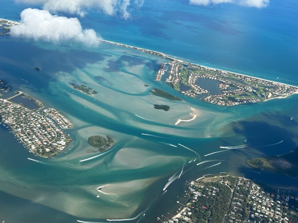
II. AERIAL TAKEN AUGUST 26, 2022.  This photos show regrowth of seagrasses.

As the August 26, 2022 photograph shows, seagrasses had rebounded in the southern Indian River Lagoon after years of damaging discharges. The worst recent Lake Okeechobee discharges were between the years of 2013 and 2018.

St. Lucie seagrasses are critical water and wildlife habitat. Especially as the seagrasses in the central northern lagoon have disappeared at such an alarming rate that a high number of manatees have starved to death.  

In recent years FWC has been feeding Indian River Lagoon manatees romaine lettuce as they have no secure seagrass food source. This is not sustainable. All political policy must specifically support the betterment of water quality and the return of seagrasses of the Indian River Lagoon. This began yesterday with an Executive Order  of Governor Ron DeSantis. See section 2.

-ALL OF ED’S AERIALS January 8, 2013, around 12:30pm.

-EXTRA and WONDERFUL NEWS. Click on photos to enlarge.

The next day, January 9th, Ed went flying with artist and friend Geoffrey Smith to relocate a very endangered Right Whale and her calf that Geoffrey had spotted in the Hobe Sound area just south of the St. Luice Inlet, on January 8, 2023. With his permission, I am sharing Geoffrey’s photos.

Wonderful news that our St Lucie is looking better. We must continue to take the protection of seagrasses and water quality seriously.

-Photos and mapping of Right Whale and Calf off of Hobe Sound in Atlantic Ocean.  Geoffrey Smith, January 9, 2023.

AREA CANALS DRAINING TO SLR/IRL

SFWMD canal map showing canals that drain lands and thus negatively affect water quality in the St Lucie River.

Documenting the Discharges, December 2020

Documenting the Discharges, December 2020

Eyeonlakeo

I posted most of these photos on Facebook, but today I will give explanations and document on my blog. From above, our St Lucie/Indian River Lagoon remains beautiful, but we must be sensitive to the losses beneath the waters. These aerials were taken during  a “slack tide” between 12 and 2pm on December 9, 2020 by my husband, Ed Lippisch. December 9th was the last of five days the ACOE stopped discharging from Lake Okeechobee; however S-80 was discharging “local runoff.” (Click on chart above.) Unfortunately, due to high lake level and lack of storage reservoirs, since these aerials were taken, the ACOE has begun ramping up Lake discharges once again. 

Below Lawrence Glenn of the South Florid Water Management gives a comprehensive ecological report covering low-salinities and loss of oyster spat in the St Lucie and other aspects, positive and negative, for the entire Everglades system.

Below is an explanation of aerials documenting discharges December 9, 2020. All photos by Ed Lippisch.

-S-80 at St Lucie Locks and Dam discharging local basin S-80 runoff on December 9, 2020

S-308 at Port Mayaca, Lake Okeechobee closed on December 9, 2020. No algae visible. 

-Plume of along Jupiter Island south of St Lucie Inlet

-Dispersing plume in Atlantic Ocean just past Peck’s Lake in Jupiter Narrows

-St Lucie Inlet -St Lucie Inlet State Park, Sailfish Point, Sewall’s Point, Stuart, Jensen 

-Looking north to Sailfish Flats between Sewall’s Point and Hutchinson Island. This area has greatly degraded since 2013 as far as loss of seagrasses and fishing opportunities 

-The area below, especially around Sailfish Point, was once considered “the most biodiverse estuary in North America” as documented, first, by Grant Gilmore

-This photo reveals seagrass loss across many areas of the Sailfish Flats 

-Another view between Sewall’s and Sailfish Point, a seeming desert…

-Close up, Sailfish Point 

-Sewall’s Point, east Indian River Lagoon 

-Sewall’s Point is a peninsula surrounded by the St Lucie River on west side, and Indian River Lagoon on east side 

Ed Lippisch, selfie. Thank you Ed! 

As you can tell, I have lots of people helping me. Whether it is Ed flying or my brother Todd who provides an incredible easy to read website called EyeonLakeO. You can click below to check it out. The more we know, the more we document, the more we can overturn the destruction of our beloved estuary…

Eyeonlakeo website by my brother, Todd Thurlow. 

Documenting the Destructive Discharges, SLR/IRL 3-15-15

Flight over Crossroads at confluence of St Lucie River/Indian River Lagoon with St Lucie Inlet in distance to the right of Sailfish Point. This area has been documented as the central point of the highest fish bio-diversity in North America by Dr Grant Gilmore. (Photo Ed Lippisch and Jacqui Thurlow-Lippisch 3-15-15.)
Flight over the “Crossroads” at confluence of St Lucie River/Indian River Lagoon south and east of Sewall’s Point. 700 acres of seagrass between Sewall’s Point and Sailfish Point has been documented as containing the highest fish bio-diversity in North America by Dr Grant Gilmore. The releases destroy this biodiversity and kill seagrasses.  (Photo Ed Lippisch and Jacqui Thurlow-Lippisch 3-15-15.)

Very Southern Tip of Sewall's Point 3-15-15. (Photo JTL)
A dark southern tip of Sewall’s Point looking towards St Lucie Inlet, 3-15-15. (Photo JTL)


Flying over South Sewall's Point the discharges are seen in their full entirety. Water usually bluish in color is dark brown. (3-15-15)
Flying over south Sewall’s Point, SLR west, IRL east, —looking north the discharges are seen in their full entirety. Water usually bluish in color is dark brown. (3-15-15)


Ed  in front of me.
Ed in front of me in Cub with Hutchinson Island in foreground. “Thank you Ed, for helping document the discharges.”

Yesterday, around noon, hours into an outgoing tide, once again, my husband Ed and I flew over the rivers to document the polluted discharges from Lake Okeechobee and the area canals pouring into the St Lucie River/Indian River Lagoon.

Today I am going to incorporate the “latest” information I have received:

1. The photos from 3-15-15 throughout this blog.

2. The ACOE press release is from 3-12-15:

ACOE Press Release,  3-12-15.
Classification: UNCLASSIFIED
Caveats: NONE
All,
Corps has decided next pulse release will be the same as last week–2,500
cfs west and 950 cfs east averaged over seven days. More information is
attached.
Please contact me if you have questions. Thanks for your help.
JHC
John H Campbell
Public Affairs Specialist
Jacksonville District, US Army Corps of Engineers
Jacksonville, FL
Office: 904-232-1004
Mobile: 904-614-9134
Join our online communities: http://about.me/usacejax/
Classification: UNCLASSIFIED
Caveats: NONE

3. Florida Oceanographic’s  water quality chart, 3-12-15.

Water Quality chart 3-12-15. (Florida Oceanographic)
Water Quality chart 3-12-15. (Florida Oceanographic )

4. The SFWMD’s “water input” chart, 3-3/3-9-15.)

3-3-15 through 3-9-15.

As you can see above, last week with Lake Okeechobee around 14.7 feet, the Army Crop of Engineers, (ACOE) with the input of the South Florida Water Management District (SFWMD) and stakeholder from 16 counties: “decided next pulse release will be the same as last week–2,500 cfs west to the Calooshatchee and 950 cfs east to the St Lucie/SIRL averaged over seven days…(If this is confusing, a useful way to convert is to know that every 1,000 cfs is equivalent to 650 million gallons per day!)

Lake O level ACOE: (http://w3.saj.usace.army.mil/h2o/currentLL.shtml)

Today the Lake Okeechobee  is reading 14.56 feet. It is going down thankfully and the goal would be 13 feet if the ACOE and SFWMD were allowed to say it…. 

These releases could not come at a worse time, as we are already inundated by area canals and it is the beginning of spawning season, oyster spating season, and the warm weather drawing the public to area waters, like the Sandbar in the photos below.  This year, the ACOE has been dumping since January 16th, very early in the year,  foreshadowing another  possible toxic summer.

In response to these releases, last Thursday, many  of the “River Movement” including the River Warriors, continued their fight for clean water at the SFWMD as hundreds pleaded for US Sugar option lands to be purchase south of Lake Okeechobee in order to, over time, create a reservoir to store, clean and convey water “south” to the water starved Everglades.

The people realize the amounts of water coming into Lake Okeechobee from the Kissimmee River are so tremendous there is no other way to offset the destruction of the estuaries except with a third outlet south of the lake. Activists have been pushing for the this for decades but since the toxic summer of 2013, known as the “Lost Summer” a tipping point has been reached.

The goal is to save the St Lucie/S. Indian River Lagoon, the Caloosahatchee, and the Florida Everglades! Call to action video here: (https://vimeo.com/119495955)

The Crossroads off of Sewall's Point. (Photo 3-15-15, JTL)
The Crossroads off of Sewall’s Point looking towards the Jupiter Narrows and the SL Inlet. (Photo 3-15-15, JTL)

Murky greenish water could be seen in the area of the Sandbar and some remaining sickly looking seagrass beds were visible. (Photo JTL.)
Looking towards Stuart and S. Sewall’s Point, murky greenish water could be seen in the area of the Sandbar and some remaining sickly looking seagrass beds were visible. (Photo JTL.)

Off Sewall's Point.
IRL and SLR waters between S. Sewall’s Point, Sailfish Point looking at the “Sandbar.” (Photo 3-15-15, JTL.)

St Lucie Inlet, 3-15-15. (Photo JTL)
St Lucie Inlet. Plume going over “protected” near shore reefs.” 3-15-15. (Photo JTL)

Plume exiting St Lucie Inlet over near shore reefs just over a mile offshore. (Photo 3-15-15,  JTL)
Plume exiting St Lucie Inlet over near shore reefs just over a mile offshore. (Photo 3-15-15, JTL)

Plume dispersing in ocean. (3-15-15, photo JTL)

St Lucie Inlet near Sailfish Point 3-15-15. (Photo JTL)
Plume at St Lucie Inlet near Sailfish Point (foreground) and Jupiter Island in distance,  3-15-15. (Photo JTL)


What Exactly is Bioluminescence in the Indian River Lagoon? Is it a Good or Bad Sign?

bioluminescence
“The dinoflagellate, (marine plankton), Pyodinium bahamense is what “produces the light show in the IRL.” Photo credit: https://getupandgokayaking.com

About a week and a half ago, my mother sent me an email with photos of my father and her on a kayak trip at night in the Indian River Lagoon. She had seen an article in the Stuart News about a company called Motorized Kayaks of the Treasure Coast and their trip into the light show of bioluminescence that has been occurring off our shores.

First, I thought about how cool my parents are to be going on kayak trips in their mid- seventies, and second, I thought, “aren’t these little plankton creatures a kind of algae bloom, and aren’t algae blooms bad for the lagoon in spite of bioluminescence’s beauty?”

Algae blooms have been linked to recent 60% plus seagrass die-offs, poor water quality, as well as  IRL pelican, dolphin and manatee deaths.  Super blooms, brown tides, “regular” and “toxic” algae blooms are “fed” by fertilizer, septic effluent, canal and Lake Okeechobee discharges, especially in the southern lagoon.

[caption id="attachment_2989" align="alignnone" width="300"]My father, Tom Thurlow, preparing for a kayak trip into the Indian River Lagoon to view the bioluminescent light show. (Photo Sandra Thurlow, August, 2014) My father, Tom Thurlow, preparing for a kayak trip into the Indian River Lagoon to view the bioluminescent light show. (Photo Sandra Thurlow, August 19, 2014)

Well anyway, I decided to contact Dr. Edie Widder of ORCA, the Ocean Research and Conservation Association, in Ft. Pierce, (http://www.teamorca.org/cfiles/home.cfm) and ask.

Dr Widder  is a world-renowned bioluminescence expert; she has even worked with the US Navy in the “design” of ships that would not cause bioluminescent disruption in the oceans, and thus give away their location to enemy ships.

This was my question to Dr Widder:

Dear Edie,
My parents rented kayaks to go see the bioluminescence in the IRL. It got me
thinking. Is the light caused by the same creatures that cause toxic algae
blooms in the lagoon?
Is the bioluminescence a bad sign for the health of the lagoon? Thank you.
Hope all is well.

Her response:

Hi Jacqui – It’s kind of a good news bad news story. The dinoflagellate
producing the light show, Pyrodinium bahamense, happens to be one that
produces saxitoxin. Interestingly it’s the same dino that’s responsible for
the bioluminescent bays in Puerto Rico and in those bays it doesn’t produce
the saxitoxin. Here it does. It’s not known why although I have a theory
and it has nothing to do with pollution. (It’s a long story having to do
with how their bioluminescence functions to protect them from predators
under different concentrations.)

Dino blooms are usually preceded by rain events that flush nutrients into
the water and then a series of calm sunny days that promote photosynthesis.
Blooms like the one we’re seeing now used to be routine according to some of
the older fishermen I’ve talked to. They called it fire in the water. The
fact is the water can’t be too polluted or the dinoflagellates won’t grow.
I’ll send you an article with some pictures I took.

Cheers,

Edie

Here is a photo Dr Widder took of bioluminescence in the lagoon I copied and a link to a remarkable video.

Bioluminescence in the IRL photographed by Dr Edie Widder.

Incredible pictures of barnacles feeding on bioluminescent dinoflagellates: (https://www.youtube.com/watch?v=y1jG8qFZyYY)

Thank you for sharing, Dr Widder!

In conclusion, I looked up saxitoxin and learned it is a “paralytic shellfish toxin” that is found is some shellfish and especially puffer fish. It has been found in few other places in the US as well as in  the Indian River Lagoon. I guess the little dinoflagellates, the same ones that make the pretty bioluminescence light,  not always, but sometimes, will produce this toxin which gets spread to some shellfish and some fish. If such a shellfish or fish is ingested,  it will make a human very sick.  Around 2002, 28 people got so sick here, in the Merritt Island area, and in a few other areas of the county, that now there is a permanent government ban on harvesting/eating IRL puffer fish in the entire IRL.

Since I am nowhere close to a scientist, I will just share some links below and refrain from speculating what is “good or bad. ” Nonetheless, I think I can safely say that sometimes beauty and danger walk hand in hand in this magical world of our Indian River Lagoon.

_______________________________________________________

Abstract, Saxitoxin in the IRL, US Food and Drug Administration: (http://www.researchgate.net/publication/250019725_Concentrations_of_Saxitoxin_and_Tetrodotoxin_in_Three_Species_of_Puffers_from_the_Indian_River_Lagoon_Florida_the_Location_for_Multiple_Cases_of_Saxitoxin_Puffer_Poisoning_from_2002_to_2004Sincerely)

Monitoring Toxic Algae and Shellfish in the IRL, FWC, (http://myfwc.com/research/redtide/monitoring/current/indian-river/)

Florida Today: Is the IRL OK for Play? http://www.floridatoday.com/story/news/local/environment/2014/06/14/indian-river-lagoon-ok-play/10527607/)

Dinoflagellate: (http://en.wikipedia.org/wiki/Dinoflagellate)

The Amazing Work of the Indian River Land Trust along the Indian River Lagoon

Indian River Land Trust map of acquired properties along the Indian River Lagoon.
Indian River Land Trust map of 8 major  properties aquired along the Indian River Lagoon just since 2009. (IRLT)

Today I am the guest speaker  for the  Indian River Land Trust’s  inaugural meeting of the “Ladies of the Lagoon.” And yes, I too am a founding member.

This is a particular honor for me as the land trust is located in Indian River County two north of my home county of Martin. Over the years I have gained a particular admiration for Indian River County in their independent nature and their ability to say, “no.”

In 2008 as the Great Recession hit with terrible intensity and unemployment rose and real estate prices fell, the Indian River Land Trust said “no” to more development and destruction of habitat along the Indian River Lagoon. In the depths of the recession they saw an opportunity and in 2009, long before the river movement began in 2013, the IRLT board decided to make purchases along the Indian River Lagoon its #1 priority. And in a short four years since that time they have raised unbelievable amounts of money,  applied for grants, and have acquired eight major shoreline properties  as shown in the map above: Coastal Oaks Preserve; Lagoon Greenway;  Bridge View Parcel; Bee Gum Point; Winter Beach Salt Marsh; Quay Dock Kayak Launch; Pine Island and the Toni Robinson Waterfront Trail. Amazing!

The non-profit Indian River Land Trust was founded in 1990 by local artist and environmentalist  Toni Robinson. As she is quoted in Vero Beach Magazines’s November 2013 issue: ” We saw the threat of “concrete canyons” drawing closer to the Treasure Coast.” (http://www.indianriverlandtrust.org/cfiles/home.cfm?csintro=yes)

The main impetus for this was the seemingly “doomed fate” of  the long standing tourist attraction, McKee Jungle Gardens, to become a shopping center. Mrs Robinson and her comrades in arms would not have this and the Indian River Land Trust was born. McKee stands  today as a symbol of what local people can do to mobilize– rejecting the “inevitable,” and thus protecting, and saving,  beauty, history, and nature, for today and generations to come.

Although the northern part of the  Indian River Lagoon in Brevard County lost the most seagrass during the super, secondary and brown tide of 2011-2013, according to Dr Eddie Widder of Orca, Indian River County proper has lost 32,000 acres of seagrasses. A tremendous loss. (http://floridaswater.com/itsyourlagoon/), (http://www.tcpalm.com/news/2013/mar/26/seagrass-die-off-one-of-major-issues-addressed/)

As state and federal  agencies document the seagrass loss as a “mystery” and are  scrambling for answers, we know that there are multiple problems causing the destruction of our beloved  Indian River Lagoon.  

It is a no-brainer that long term development of shoreline habitat, perhaps the hardest to undo, is certainly in the top two.  The population along the 156 mile lagoon has slowly gobbled up, and filled most every shoreline “lot” with a beautiful home, torn down native vegetation, installed sprawling turf grass that comes with fertilizer, pesticides, seawalls and no where for wildlife to live.

Kudos to the quiet “Campaign to  Save Our Indian River Lagoon” of the Indian River Land Trust!