A lone sailboat is a sea of blackness, confluence of the St Lucie River/Indian River Lagoon, once considered the most biodiverse estuary in North America and full of seagrasses, a nursery for the ocean..http://w3.saj.usace.army.mil/h2o/plots/s308h.pdfI am very fortunate to have a small army of people helping me document the Lake Okeechobee discharges this year. Presently, it is the tremendous rate of government sponsored discharge from Lake O that is destroying the regions’ economy and ecology, right before our eyes, ~once again.
Friends of my husband, pilots Dave Stone and Scott Kuhns, took these aerials yesterday, 11-8-17 around 5 pm. When I asked Scott about the plume, he relayed that it went 15 miles south almost all the way to Jupiter Inlet, and since there is also rain driven, fresh, dark- stained water flowing out of the Jupiter Inlet (not over-nutrified, black-sediment water from Lake O) there was no clear delineation of blackened plume to aqua ocean water, like usual–rather, the waters are all dark….
“How far did the plume go east from the St Lucie Inlet?” I asked. “From the coast, as far as the eye could see…”
End of plume, near Jupiter InletAnother angle end of plume near Jupiter InletUp close of a boat in the plume. Look at the sediment! Covering what once was seagrasses and killing our near shore “protected” reefs.Plume in black water. Brown on black. The ocean? You’d think it was an oil spill.Plume as seen at mouth of St Lucie Inlet near multi million dollar homes in Sailfish Point.Plume at mouth of St Lucie Inlet on south side as seen against Jupiter Island’s state park/Jupiter Narrows.A lone sailboat is a sea of blackness, St Lucie River/Indian River Lagoon, once considered the most biodiverse estuary in North America and full of seagrasses, a nursery for the ocean.Plume exiting St Lucie InletThe north Jetty at the St Lucie Inlet with plume waters going into the Atlantic Ocean. The plume goes east for many miles.
*The ACOE has been discharging from Lake O since Hurricane IRMA hit on Sept 2oth, 2017. The rate of discharge has gone up and down, however increasing over recent weeks. Word is the St Lucie could be dumped on for many more months, possibly through the end of the year. So don’t count on taking your visiting relatives out fishing this holiday season even though you moved here for the water. This ecological disaster is finally seeing light at the end of the tunnel as Senator Joe Negron, alongside the public, and “River Warrior” groups, particularly Bullsugar, has pushed so hard that the SFWMD and ACOE are finally working towards building an EAA Reservoir that will begin the long journey of changing water drainage culture in South Florida, and “sending the water south.” Please get involved and learn more by viewing this SFWMD EAA RESERVOIR website:https://www.sfwmd.gov/our-work/cerp-project-planning/eaa-reservoir
*Thank you to the people, and the children, groups such as the C4CW, Rivers Coalition, grandparents’ HOA email chains, leadership at Martin Health System, and to the those working for the agencies trying to help the St Lucie. As the River Kidz say:
St Lucie River/Indian River Lagoon, (Photo Jenny Thurlow Flaugh)
Florida’s constitution is important, not only because it is the ultimate law of the state, but because it sets the people’s values before the legislative, executive, and judicial branches. These words are a reference in times of question and must be clearly written on the side of the citizen.
Right now, in Article II, Section 7, (a) “Natural resources and scenic beauty,” the Florida constitution reads:
(a) It shall be the policy of the state to conserve and protect its natural resources and scenic beauty. Adequate provision shall be made by law for the abatement of air and water pollution and of excessive and unnecessary noise and for the conservation and protection of natural resources.
Because this language is vague, ( what is adequate provision? ), and case law is sparse, these words become “overruled” by Florida Statute that clearly gives “permit holders” standing over citizens, and of course the environment making the present environmental protections in the state constitution “inadequate.”
“No action pursuant to this section may be maintained if the person (natural or corporate) or governmental agency or authority charged with pollution, impairment, or destruction of the air, water, or other natural resources of the state is acting or conducting operations pursuant to currently valid permit or certificate covering such operations, issued by the appropriate governmental authorities or agencies, and is complying with the requirements of said permits or certificates.”
So a citizen is not at liberty to sue if a polluting entity is causing environmental destruction that is acting or conducting operations pursuant to a currently valid permit protected by a state agency. And if someone attempts to sue anyway, they have no real standing in a Florida court of law.
Hmmm?
~But, what if a sinkhole spanning 45 feet opened at a Mosaic phosphate fertilizer facility leaking 215 million gallons of “slightly radioactive water,” but this news did not get to the people who have wells in the area for weeks?
~What if the Army Corp of Engineers, and the South Florida Water Management District knew they were discharging billions of gallons of toxic algae from Lake Okeechobee into a community’s river making some citizens sick, yet there was no discussion, warning, or health notices posted until the entire ocean ran green?
~What if an entity could withdraw so much water from a spring or aquifer that….
What if, is now reality.
Yes, permit holders should be “protected,” nonetheless, having a valid permit should not be a right to infringe on the health, safety, and welfare of Florida citizens. Florida citizens and their environment co-exist. When necessary, citizens should have the right to fight for a clean and healthy environment.
We all know that many of Florida’s waters are “growing greener, and more toxic.” This was recently reported by TCPalm’s Jim Turner:
“The 2016 report from the Florida Department of Environmental Protection shows a mixed bag for the state’s waters, with many trending toward more-frequent toxic algae blooms, fueled by rising nitrates from farm and residential fertilizers, sewage, pet waste and other human-related sources.”
Florida’s “impaired” waters are growing, not decreasing. More springs, rivers and lakes are in horrible condition. We see it. Like it or not, the only way to ensure an “adequate” future for Florida’s citizen’s and her waters is to find a way to create acceptable language giving people a constitutional right to a clean and healthful environment.
CRC - 2017P 23By Commissioner Thurlow-Lippisch

       thurlowlj-00038-17                                      201723__
    1                         A proposal to amend
    2         Section 7 of Article II of the State Constitution to
    3         establish that every person has a right to a clean and
    4         healthful environment.
    5
    6  Be It Proposed by the Constitution Revision Commission of
    7  Florida:
    8
    9         Section 7 of Article II of the State Constitution is
   10  amended to read:
   11                             ARTICLE II
   12                         GENERAL PROVISIONS
   13         SECTION 7. Natural resources and scenic beauty.--
   14         (a) It shall be the policy of the state to conserve and
   15  protect its natural resources and scenic beauty. Adequate
   16  provision shall be made by law for the abatement of air and
   17  water pollution and of excessive and unnecessary noise and for
   18  the conservation and protection of natural resources.
   19         (b) Those in the Everglades Agricultural Area who cause
   20  water pollution within the Everglades Protection Area or the
   21  Everglades Agricultural Area shall be primarily responsible for
   22  paying the costs of the abatement of that pollution. For the
   23  purposes of this subsection, the terms "Everglades Protection
   24  Area" and "Everglades Agricultural Area" shall have the meanings
   25  as defined in statutes in effect on January 1, 1996.
   26         (c) The natural resources of the state are the legacy of
   27  present and future generations. Every person has a right to a
   28  clean and healthful environment, including clean air and water;
   29  control of pollution; and the conservation and restoration of
   30  the natural, scenic, historic, and aesthetic values of the
   31  environment as provided by law. Any person may enforce this
   32  right against any party, public or private, subject to
   33  reasonable limitations, as provided by law.
Proposal #23 was a public proposal. It was created by Traci Deen and her students at Barry University. I sponsored their publicly submitted proposal #700450. There were other proposals also on the “rights of environment/nature” topic including 7000672 by Richard Silvestri; 7000216 by Trevor Tezel; 700739 by Richard Grosso; —submitted to Article 1, Declaration of Rights, 700558 a Florida Environmental Bill of Rights by Paul Laura; and the Rights of Nature submitted independently by Mr. David Hargrove. Thank you to all and the many others!
If you have any ideas or would like to comment, please write me directly at jacqui.lippisch@flcrc.gov or at this blog post.
*This proposal will go before the Judicial Committee on November 28 and if it makes through that committee it will go through the General Provisions committee. You can write committees here to support or express concerns: http://flcrc.gov/Committees
If the discharge waters of Lake Okeechobee filled up the City of Stuart, Florida. Last Thursday, they would have reached the top of Stuart’s iconic water tower that stands at 134 feet.
Stuart, North of Monterey.
Whereas, if the ACOE’s discharge waters of Lake Okeechobee were “filling up the City of Stuart,” last Thursday, October 26, these polluted waters, would have reached the top of Stuart’s iconic 134 foot water tower…
Whereas, once again, our economy and ecology is completed devastated, and high bacteria levels in the water are exacerbated therefrom….We shall remember this day…
We shall, therefore, designate, Thursday, October 26, as “Water Tower Day” and say together: “Lake O discharges have reached the top; this must STOP!”
Stop the Discharges
Yes, to put the Lake Okeechobee discharges into perspective, last Thursday the cumulative 2017 ACOE/SFWMD discharges from S-80 passed 134 “Stuart Feet”. The Stuart water tower is 134 feet tall. See my brother Todd’s cumulative total page below:
– In the lost summer of 2013, Stuart/Martin County received 284 “Stuart Feet”, 2.1 times the height of the tower.
– In 2017, the gates did not open until September 5. So it took only 52 days to accumulate that same amount of discharges!
– In 2013, the discharges started on May 8 (with the exception of some small pulses earlier in the year). That year, it took 91 days to hit a cumulative “134 Stuart Feet” – on August 7.
In other words, the discharges have been almost twice the rate as they began in 2013. You can see this in the slope of my brother’s graphs in the web page above. This doesn’t really mean a lot though. In 2013 the discharges didn’t really begin to accelerate until mid-July. At that point, the rates of discharge were comparable to what we are getting now.
– At the current average of about 4200 cfs, we would hit the 2013 total of 284 Stuart feet in another 42 days (December 9). If they are saying the discharges could continue for months, this could happen. We could have another record year, even though the disaster didn’t start until September. Maybe they will throttle it back a little or start pulsing again so it won’t be the case. In any event, this is already another lost year…
(This blog post was based on writing and ideas by my brother and contributing blogger, Todd Thurlow, http://www.thurlowpa.com)
* I edited this post from “today” to “last Thursday.” An ever rising story. 🙂 JTL
These aerial photos over the St Lucie Inlet were taken by my husband, Ed Lippisch, Sunday, October 29, 2017, at 1:45pm.
The number one issue here is the polluted waters of Lake Okeechobee being forced into the SLR/IRL because they are blocked by the Everglades Agricultural Area from going south.
The ACOE has been discharging Lake O waters into the St Lucie since mid-September. These over-nutrified and sediment filled waters continue to destroy our economy and ecology on top of all the channelized agricultural and development waters of C-23, C-24 and C-25. Stormwater from our yards and streets also adds to this filthy cocktail.
Near shore reefs, sea grasses, oysters, fish? A human being? Better not have a cut on your hand…Not even a crab has an easy time living in this.
We move forward pushing the SFWMD and ACOE for the EAA Reservoir with these sad photos and the fact that our waters are putrid at the most beautiful time of year as motivation. We will prevail. One foot in front of the other.
One of the most rewarding parts of my advocacy is the people I meet, especially the “young people.” As a former teacher, and having no children myself, I feel a special connection. If they ask for advice, I encourage them in every way possible to relay their story and their concerns, uncensored. “Speak out! Speak out for the environment!”
A few months ago, a young lady by the name of Mariya Feldman contacted me. She had been working as a teacher in Pahokee, Florida, and was concerned about the poor air quality caused by the burning of nearby sugar fields and the effects it had on her students’ health.
I have experienced this burning from both the air, and the ground; I was interested in her story.
Burning sugarcane fields in the EAA. (Photo Ed Lippisch and Jacqui Thurlow-Lippisch, 2012.)Well, months later, Mariya contacted me again, this time she had completed her video production. She intermixed her topic of interest, poor air-quality and human health, with the health issues regarding the 2016 toxic algae outbreak in the St Lucie River caused by discharges from Lake Okeechobee. In the months previous, I had spoken openly to her and allowed her to record my interview and use it in her video. My interview, interwoven with others is included. Mariya has collaborated well to get her point across. She is a modern day student investigative reporter. I am excited to see where her talents, technological abilities, and passions will take her in the future.
I feature her work today in a You Tube Video below. Please watch it. It will make you think!
I thank Mariya and all the young people working for a clean and healthful environment for the next generation. Never give up. Never stop speaking up! It is up to us for sure.
Martin County High School under construction. The school replaced Stuart High School and opened MCHS doors in 1964. (Ruhnke, Thurlow Collection)
Recently, I attended the ribbon-cutting for Martin County High School’s Administration and Classroom Building. They even opened a time capsule from the school’s origins in 1964. I hardly recognized the place…having graduated in 1982. It was so much bigger and better than when I attended. The place has come a long way from being what was literally once the county dump.
When I got home my mother had sent me a historic photograph via email (above.) I looked at it wondering what it was. I wrote back: “Where is that? Somewhere near Frances Langfords? IRL?”
I couldn’t believe it when she replied that it was an aerial of Martin County High School in 1964. I didn’t even recognize it! All these years, and I have never really realized the school lies so close to the St Lucie River. In fact, it lies not too far from where the South Fork of the St Lucie River was connected to the St Lucie Canal, today known as C-44. The link that allows polluted water in from Lake Okeechobee. A link that should be closed…
This Google map shows location with the purple pin.Another map from Mr Young identifying location.
In her Vignettes, local historian Alice Luckhardt writes about the first school in Stuart. ~Stuart became the county seat of Martin County in 1914:
“Stuart’s first school was a one room building, about 12 x 16 feet, built in 1891 on the banks of the St. Lucie River, to accommodate the community’s children; the first teacher was Kate Hamilton whose salary was about $30 a month, but at that time there were not 12 grade levels and very few students.”
Imagine being taught, along the shores of a clean, beautiful, fish filled, St Lucie River….what a day, what an education, that must have been….
Aerial of Martin County High School, Kanner Highway Stuart, on line -MCHS E. Hassert, TCPalm 2015Martin County, FlSFWMD canal and basin map. C-44 canal is the canal most southerly in the image.
For the record, I would like to report what I have filed, so far, as a member of the Constitution Revision Commission 2017/18.
I have filed two “proposals.”
The first is a “public proposal” (a public submission/language exactly as proposed) entitled: “Floridians’ right to a clean and healthful environment.” This proposal elevates a clean and healthful environment to a right, such as now stated in the Florida constitution: “to enjoy and defend life and liberty, to pursue happiness, to be rewarded for industry, and to acquire, possess, and protect property…” It adds a “clean and healthful environment” symbolically to our highest legal level, our constitution. Right now, the proposal also proposes to give Floridians more standing in a court of law if they have experienced special injury (economic loss) due to environmental destruction of their property. I think the wording can be ameliorated, made more preventative, and less litigious, other states have achieved this and kept their goals in place. Nonetheless, the present language remains a good place to start the conversation.
My second proposal is a “commissioner proposal,” (a proposal with my wording/with help of staff) entitled “to Establish a cabinet position for a Commissioner of Environmental Protection.” Yes, I believe the environment should have a seat at Florida’s most important table. Presently, the Florida cabinet consist of the Attorney General, the Chief Financial Officer, and the Commissioner of Agriculture. These elected public servants make decisions at the top-level with the Governor and are elected, not appointed. They lead the state. I strongly feel that a statewide elected Commissioner of Environmental Protection should exist alongside these others and not be buried under the executive branch with no clear accountability as is presently the case. “Elected and answering to the people,” not to the politics of the state; this is my goal.
The process?
Well, the first proposal, “a right to a clean and healthy environment” has been voted on by the full CRC to move forward to committee. The second will move forward as commissioner proposals do automatically.
But that’s just the beginning!
Soon, Chair Beruff, will determine what committees these proposals will have to be “heard in.” There could be one, or many. If the proposal makes it through committee, it could come out exactly the same, be amended, or die. There is a way to resurrect such later on if it does get killed, but this requires a majority vote and is no easy feat. Nonetheless, it is a possibility. The best thing is to try to get it through committee so the full commission can vote on.
The political process will take its course, and the people will be heard.
It is an exciting time for me, and I plan on submitting other proposals too, but these two, my first, are my priorities.
Below are my two proposals and other information you may find helpful. If you have questions or concerns please write me at jacqui.lippisch@flcrc.gov. I am here to discuss.
CRC - 2017P 23By Commissioner Thurlow-Lippisch
thurlowlj-00038-17 201723__
1 A proposal to amend
2 Section 7 of Article II of the State Constitution to
3 establish that every person has a right to a clean and
4 healthful environment.
5
6 Be It Proposed by the Constitution Revision Commission of
7 Florida:
8
9 Section 7 of Article II of the State Constitution is
10 amended to read:
11 ARTICLE II
12 GENERAL PROVISIONS
13 SECTION 7. Natural resources and scenic beauty.—
14 (a) It shall be the policy of the state to conserve and
15 protect its natural resources and scenic beauty. Adequate
16 provision shall be made by law for the abatement of air and
17 water pollution and of excessive and unnecessary noise and for
18 the conservation and protection of natural resources.
19 (b) Those in the Everglades Agricultural Area who cause
20 water pollution within the Everglades Protection Area or the
21 Everglades Agricultural Area shall be primarily responsible for
22 paying the costs of the abatement of that pollution. For the
23 purposes of this subsection, the terms “Everglades Protection
24 Area” and “Everglades Agricultural Area” shall have the meanings
25 as defined in statutes in effect on January 1, 1996.
26 (c) The natural resources of the state are the legacy of
27 present and future generations. Every person has a right to a
28 clean and healthful environment, including clean air and water;
29 control of pollution; and the conservation and restoration of
30 the natural, scenic, historic, and aesthetic values of the
31 environment as provided by law. Any person may enforce this
32 right against any party, public or private, subject to
33 reasonable limitations, as provided by law.
CRC - 2017P 24By Commissioner Thurlow-Lippisch
thurlowlj-00025A-17 201724__
1 A proposal to amend
2 Sections 3 and 4 of Article IV and create a new
3 section in Article XII of the State Constitution to
4 establish the office of Commissioner of Environmental
5 Protection as a statewide elected officer, to provide
6 duties of the commissioner, and to include the
7 commissioner as a member of the Cabinet.
8
9 Be It Proposed by the Constitution Revision Commission of
10 Florida:
11
12 Sections 3 and 4 of Article IV of the State Constitution
13 are amended to read:
14 ARTICLE IV
15 EXECUTIVE
16 SECTION 3. Succession to office of governor; acting
17 governor.—
18 (a) Upon vacancy in the office of governor, the lieutenant
19 governor shall become governor. Further succession to the office
20 of governor shall be prescribed by law. A successor shall serve
21 for the remainder of the term.
22 (b) Upon impeachment of the governor and until completion
23 of trial thereof, or during the governor’s physical or mental
24 incapacity, the lieutenant governor shall act as governor.
25 Further succession as acting governor shall be prescribed by
26 law. Incapacity to serve as governor may be determined by the
27 supreme court upon due notice after docketing of a written
28 suggestion thereof by fourthree cabinet members, and in such
29 case restoration of capacity shall be similarly determined after
30 docketing of written suggestion thereof by the governor, the
31 legislature or fourthree cabinet members. Incapacity to serve
32 as governor may also be established by certificate filed with
33 the custodian of state records by the governor declaring
34 incapacity for physical reasons to serve as governor, and in
35 such case restoration of capacity shall be similarly
36 established.
37 SECTION 4. Cabinet.—
38 (a) There shall be a cabinet composed of an attorney
39 general, a chief financial officer, a commissioner of
40 environmental protection, and a commissioner of agriculture. In
41 addition to the powers and duties specified herein, they shall
42 exercise such powers and perform such duties as may be
43 prescribed by law. In the event of a tie vote of the governor
44 and cabinet, the side on which the governor voted shall be
45 deemed to prevail.
46 (b) The attorney general shall be the chief state legal
47 officer. There is created in the office of the attorney general
48 the position of statewide prosecutor. The statewide prosecutor
49 shall have concurrent jurisdiction with the state attorneys to
50 prosecute violations of criminal laws occurring or having
51 occurred, in two or more judicial circuits as part of a related
52 transaction, or when any such offense is affecting or has
53 affected two or more judicial circuits as provided by general
54 law. The statewide prosecutor shall be appointed by the attorney
55 general from not less than three persons nominated by the
56 judicial nominating commission for the supreme court, or as
57 otherwise provided by general law.
58 (c) The chief financial officer shall serve as the chief
59 fiscal officer of the state, and shall settle and approve
60 accounts against the state, and shall keep all state funds and
61 securities.
62 (d) The commissioner of environmental protection shall have
63 supervision of matters pertaining to environmental protection
64 that the Department of Environmental Protection or its successor
65 agency and water management districts are required or authorized
66 by law to implement and administer.
67 (e) The commissioner of agriculture shall have supervision
68 of matters pertaining to agriculture except as otherwise
69 provided by law.
70 (f)(e) The governor as chair, the chief financial officer,
71 and the attorney general shall constitute the state board of
72 administration, which shall succeed to all the power, control,
73 and authority of the state board of administration established
74 pursuant to Article IX, Section 16 of the Constitution of 1885,
75 and which shall continue as a body at least for the life of
76 Article XII, Section 9(c).
77 (g)(f) The governor as chair, the chief financial officer,
78 the attorney general, the commissioner of environmental
79 protection, and the commissioner of agriculture shall constitute
80 the trustees of the internal improvement trust fund and the land
81 acquisition trust fund as provided by law.
82 (h)(g) The governor as chair, the chief financial officer,
83 the attorney general, the commissioner of environmental
84 protection, and the commissioner of agriculture shall constitute
85 the agency head of the Department of Law Enforcement.
86
87 A new section is added to Article XII of the State
88 Constitution to read:
89 ARTICLE XII
90 SCHEDULE
91 Recomposition of the cabinet; commissioner of environmental
92 protection.—The amendment to Section 4 of Article IV relating to
93 the election of the commissioner of environmental protection and
94 the inclusion of the commissioner as a member of the cabinet
95 shall take effect January 3, 2023, but shall govern with respect
96 to the qualifying for and the holding of the primary and general
97 elections for the office of commissioner of environmental
98 protection in 2022.
Commissioner Jacqui Thurlow-Lippisch’s CRC webpage:
Appointed by President
Committee Assignments
General Provisions, Chair
Executive
Proposals Introduced
P 0023 GENERAL PROVISIONS, Natural resources and scenic beauty
Last Action: 10/19/2017 Filed
P 0024 EXECUTIVE, Commissioner of Environmental Protection
Last Action: 10/19/2017 Filed
Biographical Information
Occupation: Former Middle and High School German and English Teacher; Presently, Licensed Realtor, Lifestyle Realty Group
City: Town of Sewall’s Point (Martin County)
Commissioner Jacqui Thurlow-Lippisch was born in 1964 at Travis Air Force Base, Fairfield, California. She is a Daughter of the American Revolution, Florida Blue Key member, a lifetime resident of Martin County and member of St. Mary’s Episcopal Church.
Commissioner Thurlow-Lippisch’s mother is a third-generation Floridian and statewide recognized historian. In 1952, Commissioner Thurlow-Lippisch’s New York grandfather founded Thurlow & Thurlow, P.A. in Stuart, which specializes in real estate, and continues today as a family run business. She is married to William E. Lippisch, D.M.D./Oral Surgeon and general aviation pilot. They are well-known on the Treasure Coast for taking thousands of aerial photographs documenting the effect of destructive discharges from Lake Okeechobee on the health of the St. Lucie River/Indian River Lagoon. She shares these photos on her blog entitled “Indian River Lagoon,” which educates thousands of people. Jacqui is a former teacher with years of classroom experience instructing middle and high school students. She continues to work with youth through “River Kidz,” a division of the Rivers Coalition that has also helped promote and inspire efforts to find solutions to the damaging discharges from Lake Okeechobee.
Commissioner Thurlow-Lippisch is a former Mayor (2011-2012) and Commissioner (2008-2016) of the Town of Sewall’s Point and has served in other various public service and leadership capacities, including: Vice-Chair, Treasure Coast Region Planning Council (2016); Chair, Treasure Coast Council of Local Governments; Treasure Coast Florida League of Cities (2008-2016); Chair, Florida League of Cities’ Energy, Environment, and Natural Resources Legislative Committee (2013); Board member, Harbor Branch Oceanographic Institute Foundation, Florida Atlantic University (2013-2016); and Rivers Coalition Defense Fund (2011-present).
Commissioner Thurlow-Lippisch holds a Bachelor of Arts, Journalism & Communications, University of Florida, 1986; Bachelor of Arts, German, University of Florida, 1994; and Master of Arts, Curriculum and Development, College of Education, University of West Florida, 1999. She also graduated from the UF/IFAS Natural Resources Leadership Institute, Class XV, 2016.
Without documentation, there is no record. With no record, there is less chance for improvement.
Yesterday, Ed, Luna, Bo and I continued to document the discharges, right now, coming mostly from Lake Okeechobee.
There are serious signs of stress in the estuary including reports of leisoned fish that I have posted on Facebook. The rest, from above, we can see for ourselves…
“Keep the pressure on” for the reservoir and for replumbing the great state of Florida.
Say No to Lake O
“Say No to Lake O,” this is one of the rallying cries of the River Kidz. If only it were as easy as just saying “no.” According my numbers-man, my brother Todd, the “St Lucie River has taken in more than 86+ billion gallons this year, enough to put Stuart under 111 feet of water. This is only enough to take 6 inches off of the lake.” The west coast is taking most of the lake level reducing water and of course they are screaming “say no to Lake O” too.
Eco-Voice, present west coast advocacy, 10/17.Realistically, with the Army Corp of Engineers reporting the Lake level at 17.07, today, it will be a few more weeks of releases to get near or under 16 feet. A safer number for the dike and for the people who live in fear of it breeching. Not to mention the 525,000 of acres of protected sugarcane… http://w3.saj.usace.army.mil/h2o/reports.htm
Black Gold, the muck soils south of Lake Okeechobee. (Photo JTL, 2014.)I do believe the authorities are getting the message, though…so keep screaming. SAY NO TO LAKE O! For everyone!
I think our water culture is changing, and the government is being forced/inspired so they can get reelected and respected…. to improve our water/rivers situation. Just yesterday, I got an email about a woman whose Bascom Palmer doctor notes she has an eye infection in her cornea very possibly from “walking the bridge,” repeatedly over the St Lucie River.
I am not making this up.
These health issues are real. More and more people are realizing this. Lake O and other canal unfiltered pollution must halt.
So it looks like the Lake Okeechobee is going down, but we are still going to get releases for while. (See the info below on my brother’s site.) Things are still bad, but they are getting better.
~Never stop screaming “Say No to Lake O,” we owe it to ourselves, and to the future.
Hydro. Lake is going down._________________________________________________________________
Great information below!
Jacqui,
It looks link the lake is coming back down. See the graph links on my Firm Favorites Page:
It’s hard believe that we have taken 86+ billion gallons this year, enough to put Stuart under 111 feet of water. But this is only enough to take 6 inches off of the lake. The west coast is taking most of the lake level reducing water.
By the way, I have a new link of my Lake O Satellite imagery page that will actively pull up the last 7 days of low res images from all three satellites: St Lucie River Discharges Latest Lake O Satellite Imagery (http://www.thurlowpa.com/LakeOImagery/) Click on the “Terra/Aqua/Suomi Last 7 days icon”.
Best regards,
Todd
Thomas H. Thurlow III THURLOW & THURLOW, P.A. 17 Martin L. King, Jr. Blvd. Suite 200 P.O. Box 106 Stuart, FL 34995-0106 Phone: (772) 287-0980 Facsimile: (772) 220-0815 Email: todd@thurlowpa.com Web: http://www.thurlowpa.com
Guest blog an photos by Geoff Norris, Indian River Plantation POA Group:
Guest blog an photos by Geoff Norris, Indian River Plantation POA Group:
These photographs of the Indian River Lagoon were taken on 11 October 2017, between the bridge at East Ocean Blvd, Stuart and north to Indian Riverside Park and Jensen Beach, Florida. The lagoon waters have been polluted for several days with run-off from Lake Okeechobee making the lagoon various shades of brown, orange, red and grey, with dirty scummy foam a feature at the shorelines and also as foamy windrows and wave crests in open water. The St Lucie River is in much the same state.
During this time the Army Corps of Engineers has been opening the locks at Port Mayaca to discharge water from Lake Okeechobee down the St Lucie Canal to the St Lucie River/Indian River Lagoon estuarine system. Rates vary from 4500 to 5500 cubic feet per second, equivalent to 2.9 to 3.5 billion gallons per day. It has been calculated that this amount of discharge would cover the Stuart peninsula north of Monterey Road with four feet or more of water in one day.
The Florida Oceanographic Society reports for 10 October 2017 that salinities in the Lagoon have been drastically reduced by this lake discharge to between 1 and 3 parts per thousand sufficient to kill many estuarine fish and other plants and animals (normally the salinity would be between about 20 and 25 parts per thousand in this section of the lagoon). The Society has graded the overall health of the Lagoon on either side of the East Ocean Bridge as “Poor to Destructive”. See this link:
The Army Corps of Engineers is aware that they are killing the St Lucie/Indian River Lagoon estuarine system by their actions, but consider it more important to lower the Lake Okeechobee level from the current level of 17.2 (feet above mean sea level) to a desired level of between 12 ft and 15 ft.
These are the facts. It is also a fact that politicians have not managed to stop this destruction.
Flight over SLR/IRL to view canal C-23, C-24, C-25 and especially present high releases from Lake Okeechobee through C-44 Canal. JTL/EL 10-14-17
Yesterday, I asked Ed to take me up in the plane, once again to document the discharges. In the wake of much rain and an active hurricane season, the St Lucie River/Indian River Lagoon continues to sacrifice its economy, health, and ecosystem for the EAA and South Florida drainage. A standard operating procedure that is outdated and dangerous.
The discharges from Lake O. have been on and off since Hurricane Irma hit on September 20th. Presently they are “on,” and it shows. Right now our river and ocean shores near the inlet should be at available to boaters, fisher-people, and youth, in”full-turquoise-glory.” Instead, the estuary, beaches, and near offshore is a ghost-town along a chocolate ocean and a black river. The edge of the plume can hardly be distinguished as all is dark, sediment filled waters. A disgrace.
ACOE 10-15-1710-15-17 Lake O is high. This is a threat to those who live south and around the lake.South Florida’s southern Everglades, 1850 & today. The water that used to flow south now is sent to the ocean and Gulf of Mexico through canals C-44 (SLR) and C-43.(Cal.) (Map courtesy of SFWMD.)Image showing drainage of S. Florida through St Lucie and Caloosahatchee rivers. These rivers, that God did not connect to Lake Okeechobee, have been channelized by humans to dump Lake O. This drainage system put in place in the 1920s does not serve Florida today. Not economically, health wise, or environmentally. We must continue to push to replumb the system the best we can. (Public image.)
I told Ed it’s best not to smile for this photo. We look forward to seeing the model and timeline from the SFWMD and ACOE for Senator Negron’s reservoir, and the beginning of turning this century old nightmare.
SFWMD basin map for SLR showing canal discharge structures.
One thing’s for sure, if you don’t have small fish, you won’t have big fish. Being a little fish is actually the most important thing in world. A small fish is a “big fish” we could say, part of it anyway… As kids, we learn about the food chain and it makes perfect sense. All life is dependent upon another; everything is connected.
I have to say when Cameron Jaggerd contacted me, I had to look up “menhaden” in Wikipedia. I was not familiar with the name. When I saw this fish has many names such as shad, bunker, shiner, and pogy, I recognized it.
All those names, incredible! It is obviously an important fish to many regions, and to many people. In fact, I found an article in The American Naturalist entitled “A Study of the Popular Names of the Menhaden,” noting there are over 35 names!
Cameron invited me to attend today’s public hearing to support this important and underrated fish. I hope you can attend too. I myself have witnessed the beauty of terns catching the smallest of these fish, silver-sparkling, like metal against the sun. So beautiful! So important! An inspiration! We must protect these filter-feeding little-big guys, who clean our waters, and feed the world.
Below, Cameron gives great insight and teaches about the history and politics of tonight’s public hearing. His contact info is below.
Hi Jacqui,
My name is Cameron Jaggard and I work on public policy, specifically fisheries management, at The Pew Charitable Trusts. I am based in North Palm Beach and grew up on the southern stretch of the IRL. I am contacting you because there is an important public hearing scheduled for October 10 6pm at the Melbourne Beach Community Center that I thought you’d want to attend. This hearing, the only one in the South, will help decide the fate of “the most important fish in the sea,” also known as Atlantic menhaden or pogy.
With strong encouragement, the Commission could decide to leave hundreds of millions more menhaden in the ocean to grow abundance and provide for predators, such as tarpon, king mackerel, and osprey, or, without it, they could stick with the current single-species approach and likely take hundreds of millions more out of the ocean for fish meal, pet food, and other products. Issue 2.6 Reference Points – Option E of draft Amendment 3 is the option that gets us to this 21st century approach as soon as possible and as such, enjoys broad support from conservation groups (e.g. Audubon, Earthjustice, Wild Oceans, FWF), fishing organizations (e.g. IGFA, ASA, CCA, TRCP, Anglers for Conservation), and the best available science. As a matter of fact, Stony Brook is currently championing a PhD sign-on letter in support that currently has over 100 signers. This piece from Ed Killer last week gives a nice local take on what’s at stake http://www.tcpalm.com/story/sports/outdoors/fishing/2017/09/28/most-important-fish-sea-discussed-oct-10/711709001/
This hearing is a rare and important opportunity for you, your family, and friends to affect change that could have widespread, positive impacts for menhaden, their predators, and the people who depend on them. I heard the big commercial menhaden fishery had 150-200 folks turnout at hearings up north last week. This will be the only hearing in the South, vey important.
Also…I was trying to think of how you could best relate the story of menhaden to your readers. Some thought bubbles I came up with during this brainstorm are below. Seems there are some clear parallels between menhaden and the IRL. Specifically, that we want management of water and management of menhaden that benefits all, not just a select few businesses. Maybe these thoughts will provide some useful inspiration for your story or maybe not.
· Menhaden might not be well known outside of the fishing world, but their plight should be familiar to all those who have fought for the health of the Indian River Lagoon. Much as Florida’s water management has been shaped by Big Sugar, menhaden have been at the mercy of the commercial menhaden reduction fishery, which nets and vacuums menhaden out of the sea to be ground up and processed, like sugar cane, into ingredients for everything from cosmetics to pet food.
· This one-sided approach has produced very clear benefits for these special interests, while leaving everyone else who depends on healthy estuaries and plentiful menhaden in the lurch.
· Now, a proposed rulemaking, known as Amendment 3 to the…, could flip the tables and see to it that an important public trust resource is managed to the benefit of all.
o With your support, Amendment 3 could put much needed restraints on the commercial menhaden fishery to ensure we leave enough menhaden in the ocean to provide for the predators and people that depend on them from Florida to Maine.
· If you support this equitable approach to managing our precious natural resources, I encourage to attend the menhaden hearing today, October 10 6pm at the Town of Melbourne Beach Community Center and make sure to speak in favor of “Reference Points Option E.” Please also submit a written comment in support of “Reference Points Option E” to comments@asmfc.org with the subject “Draft Amd. 3” by October 24, 2017. For more information on Amendment 3 please visit http://www.pewtrusts.org/en/research-and-analysis/blogs/compass-points/2017/08/31/fate-of-most-important-fish-in-the-sea-hangs-on-commission-decision
FAQ:
(1) What’s happening?
The state officials that set rules for menhaden commercial fishing along the East Coast, the Atlantic States Marine Fisheries Commission, will decide at a November 13 meeting in Baltimore how to move forward a new management model for this important fish. While fisheries managers throughout the country are starting to set catch limits for forage fish like menhaden in a way that leaves enough in the ocean for predators to eat, it will make history if menhaden are managed this way. That’s because menhaden is the biggest fishery by volume on the East Coast, and third in the country, after Alaska pollock and Gulf menhaden.
(2) What’s the timing?
Now is the chance for the public from Maine to Florida to influence the outcome. Until October 24, the Commission is inviting comment on menhaden management from the public in every state through in-person hearings, and emailed or written comments. This hearing is the only one in Florida. ASMFC has asked comments be submitted to comments@asmfc.org with the subject line Draft Amd. 3 . Pew has an action alert for people to submit a comment http://advocacy.pewtrusts.org/page/13431/-/1?_ga=2.234760734.140280769.1505740197-721074420.1504012946 .
(3) Why do people here care?
Menhaden (also called bunker and pogy) are prey for many species that people care about. Recreational fishermen want to see plentiful menhaden in the water for tarpon, king mackerel, billfish and more to eat; same goes for birders looking for eagles and ospreys and whale-watching tourists and residents looking for humpbacks close to shore.
(4) Who can I talk to?
I can arrange a time for you to speak with Pew’s Joseph Gordon, who leads the Mid-Atlantic ocean conservation team and can give you the national context for this issue; here’s his latest Pew blog on menhaden. A member of Joseph’s team will be at each hearing and can help you find people to talk to there, so let me know if you’d like to be in touch with him.
(5) Are there any visuals?
Great visuals are out there on menhaden and their predators. In the last few summers, videos showing these species feasting on menhaden (see this shark video and this humpback video as examples) are popular.
(6) What’s interesting about menhaden?
Many people may not have heard of menhaden, because they don’t end up as seafood in this country. Commercial fishing for menhaden is mostly a “reduction” fishery that grinds them into pet food, fertilizer and fish oil; about a quarter of menhaden caught end up as bait for other fishermen to use. Despite menhaden being one of the country’s biggest fishery by volume, there were no catch limits at all until 2013. While the menhaden population seems to be growing, it is still at near-historic lows. It was much larger in the 1960s, 70s and 80s, before hitting lows in the 1990s and 2000s.
Best Wishes,
Cam
Cameron Jaggard
Principal Associate, U.S. Oceans, Southeast |
The Pew Charitable Trusts | c: 202-590-8954 |
e: cjaggard@pewtrusts.org | pewtrusts.org
Twitter: @Coastal_Cam
Menhaden
Shad, bunker, shiner, pogey, and no telling how many other names, are all describing the menhaden (Brevoortia patronus). They grow to approximately one foot and are very similar in appearance to the freshwater shad, but are not the same fish. Menhaden are extremely oily, which is why they have been commercially netted for so many years for the oil and meal that can be produced from them. They are many people’s “secret” bait for almost all species, using them alive, dead, or cut. They should be hooked just like all the other baits that I have written about so far — For trolling, hook them through the nose; for bottom fishing, through the nose or over the anal fin; and as cut bait, they should be cut diagonally and hooked over the top of the cut surface.
Menhaden are plankton filter feeders and can only be caught with a cast net since they won’t bite a hook. Sometimes when you see bait “striking” or rolling on the surface, it is a school of menhaden making surface slurps of minute surface food items. We used to be able to spot menhaden inside Tampa Bay in the summer time by the oil slick that will form over a large school. They also have a very distinctive smell if you are downwind of them. They are a very fast moving fish, and usually by the time you see them on your fish finder, they have moved far enough away from the boat so that you cannot net them. We try blind throws of the cast net in the area where we can see them flipping on the surface; this usually will produce bait. Menhaden are also very intolerant of low dissolved oxygen and will die quickly in a poorly aerated live well. Still, they are five star on my list of baits.
Just as a note, if you have never seen live menhaden, many of them have a small critter that comes crawling out of their mouths when they die. This is quite a surprise the first time you see it. It appears to be some sort of shrimp or crab that looks like a mantis shrimp and must live inside the mouth or gill area without hurting the menhaden. I don’t remember seeing this written about in any of the fish books, but surely some biologist somewhere has seen this.
The following is a texting conversation between my brother, Todd, and me, just over an hour ago. As you can see, Todd keeps me in real-time. Now, I wish to share with you.
Todd: Hi Jacqui, looks like it’s “balls to the wall” —like the old jet fighter saying.
Lake O is at 17 feet and rising…
Jacqui: Holy —! Didn’t Gary Goforth say the max for S-80 is 12,000 CFS? How much is this?
Todd: This is normal high-end. ~4000 cfs. In 2004-2005 it looks like they maxed at 5-6000cfs. I’ll graph against the lake stage.
Jacqui: How do u know it’s 4000? I see nothing posted 4 today on ACOE site.
Todd: S-80 hit 6,727 cfs on 10/06/2004. The lake was at 17.86 and rising it peaked at 18.02 on 10/13/04.
Hurricane Jeanne had hit days earlier on Sept. 25
Jacqui: I remember that. Bad.
Todd: Also. The 4000+ right now is instantaneous. The stats you always see are a mean for the day. Right now that are piling between 1000cfs and the high 5000s. It looks like they did almost hit 6000 earlier today.
Pulsing not piling.
Jacqui: Awful. I think it stinks that unless you know how to access all the technology, you don’t know the river is getting slaughtered until the following days. A nightmare. Thanks Todd. Goodnight.
Today is October 7th, 2017 and I am sharing photos taken October 6th, 2017 in the area of the St Lucie Inlet displaying the recent discharges from Lake Okeechobee and area canals. The plume was measured four miles out, this is very far, and can be seen both north and south of the inlet. The edges are churned up and blurred, and there are many layers fanning out.
I share to document. I share in hope of eventual change, and I share to inspire the so many people who are causing change, change, that one day we will see in a better water future.
Thank you to my husband Ed for piloting, and to passenger, and photographer, Matt Coppeletta.
Sincerely,
Jacqui
All photos taken of the St Lucie Inlet area on 10-6-17 by Ed Lippisch and Matt Coppeletta. Discoloration of water is caused primarily by discharges from Lake Okeechobee but also from canals C-23, C-24, C-25 and area runoff.
The population increase of the Goliath Grouper is one of those rare “feel-good” conservation success stories. With the help of a 1990 law of protection, the species has come back from being historically over-hunted.
I was recently contacted by advocate goliath grouper protectionist, Ms. Katie Carlsson, who spurned my interest in the debate to “reopen hunting on the species.” I also knew I could share my mother’s plethora of historic St Lucie River “Jew Fish” photos labeled such during the non-politically correct era that was part of my childhood and before. In today’s blog post the original terminology is used in the photographs as documented.
Now for today’s “Goliath Grouper!”
I wanted to speak up for Katie’s cause, questioning the reopening of the hunt. She has forward much information on FWC meeting dates, etc. Thank you Katie.
Before presenting you with many links to explore and opinions to read, I will say, that according to the Snook Foundation, “vast technological improvements in spear guns and diving equipment in the 1960s and 1970s made no wreck, cave or hole safe for Goliath grouper to hide. They have few natural predators and little fear of divers.They are easy prey.”
Of course anglers have the right to argue that the grouper in some areas, like South Florida, have been perhaps “too successful” and believe hunting should be reopened.
My question is if the giant fish will basically look you in the eye and let you kill it, or if there is a question as to the efficacy of the conservation program, why do it? There are so many other fish in the sea.
These are the locations and dates for future hearings:
Oct. 9: Jacksonville, Pablo Creek Regional Library, 13295 Beach Blvd.
Oct. 10: Titusville, American Police Hall of Fame & Museum, 6350 Horizon Drive.
Oct. 11: Stuart, Flagler Place, 201 SW Flagler Ave.
Oct. 12: Davie, Old Davie School Historical Museum, 6650 Griffin Road.
Oct. 16: Pinellas Park, Bill Jackson’s Shop for Adventure, 9501 U.S. Highway 19 N.
Oct. 17: Port Charlotte, The Cultural Center of Charlotte County, 2280 Aaron St.
Oct. 18: Naples, Collier County Public Library – South Regional, 8065 Lely Cultural Parkway
Oct. 25: Tallahassee, FWC Bryant Building, Room 272, 600 S. Meridian St. (6-9 p.m. ET)
Man with Goliath Grouper, photo of Harold R. Johns family, c. 1925, St Lucie River, from the archives of Sandra Henderson Thurlow.Fishermen with Goliath Grouper, Stuart, Florida photo of Harold R. Johns family, c.1925, St Lucie River, from the archives of Sandra Henderson Thurlow.Goliath Grouper caught near today’s Roosevelt Bridge in downtown Stuart c. 1920. Photo of Homer Hines Stuart Jr. from the archives of Sandra Henderson Thurlow. (This photo is similar to the one below.)“This photograph of jewfish suspended from a pole resting on a Florida East Coast Railway car was taken in what was called the hole, a rail spur that went down to the St Lucie River near the Stuart freight depot. (Homer Hines Stuart Jr.)From page 50 of “Stuart on the St Lucie” by Sandra Henderson Thurlow.“This postcard illustrates the use of President Grover Clevland’s name to promote Stuart. Joseph Jefferson, a famous actor of the day, also fished in the St Lucie River region” in the early late 1800s. Cleveland was president 1885-89 and again in 1893-97. (Photo courtesy of page 51 of “Stuart on the St Lucie” by Sandra Henderson Thurlow.)Photo by Earl Dyer Ricou, Stuart, Fl, c. 1950. (Archives of Sandra Henderson Thurlow.)A dead Goliath Grouper that washed ashore near Bathtub Beach in Martin County, 2011. Goliath Grouper do not spaun until approximately six years of age and are believed to be able to live from 50 to even 100 years of age. They can weigh over 800 pounds. JTLMy corgi, Baron, gives perspective to the size of a Goliath Grouper. 2011, JTLCourtney of “Fishens Magazine.” Photo taken prior to restrictions put in place in the 1990s. History shows, unfortunately, it is the nature of people to take more than they need.
This is a link to the hearing in Key Largo. If anyone goes to hearings this can prepare them for what to expect and the information that FFWC is sharing.
In the earlier part of the last century, Atlantic goliath groupers were abundant from Florida to Brazil and throughout the Gulf of Mexico and Caribbean Sea. If you have been lucky enough to be in the water with these creatures, then you appreciate their unflappable personality and awe-inspiring size, which reaches up to 8 feet and 1,000 pounds. The goliath grouper has no natural predators besides large sharks and humans. We are writing with regards to the latter.
Goliath groupers reached commercial extinction in the late 1980s. For this reason, in 1990 a federal and state ban on killing them was implemented for U.S. federal waters and state waters of Florida, Alabama, Mississippi, Louisiana and Texas, followed by a 1993 ban in the U.S. Caribbean. Twenty-seven years of protection have led to a population increase, although not a recovery to pre-exploitation levels, in the state of Florida alone. Spawning aggregations are forming again off the east coast of Florida. It’s the only place in the world where goliath groupers are now reliably found in significant numbers, as juveniles in mangroves, and as adults in reefs, solitary or forming spawning aggregations. People come from all over the nation and the world to see the goliath grouper spawning aggregations in the late summer, bringing big dollars that boost local economies.
“Diving in the Palm Beaches back in the late 1980s, to see a goliath grouper was the holy grail. Many of us dove year after year, and saw perhaps one, maybe none,” said Deb Castellana of Mission Blue. “To witness the resurgence of the species since protections were enacted has been heartening, a real story of hope.”
Yet, the Florida Fish and Wildlife Conservation Commission (FWC) is currently considering allowing the limited take of goliath groupers in state waters. The proposal would allow the killing of 100 goliath groupers per year for 4 years, for a total of 400 goliath groupers. The sizes targeted are breeding individuals. If implemented, the kill will exterminate most of Florida’s breeding population of goliath groupers, destroying 27 years of conservation management effort. This “limited take” is not supported by scientific evidence. Critics of the goliath grouper say the species is overeating and responsible for declining fish and lobster stocks. Yet, actual scientific data from researchers like Sarah Frias-Torres, Ph.D. show that overfishing, not the goliath groupers, is the reason for declining fish and lobster stocks.
Some say that a “sustainable” take of goliath groupers is possible, but many scientists agree that the current population would not last more than one, or perhaps two years after opening the fishery. And groupers have no nutritional value for humans since they contain levels of mercury that are unsafe for human consumption according to the U.S. Food and Drug Administration (FDA) and the U.S. Department of Health.
“I repeatedly asked what scientific evidence the FWC has to support killing the goliath groupers, because all scientific research published to date does not support a fishery for this species and shows the species is highly conservation dependent and highly vulnerable to overfishing,” said Dr. Frias-Torres. “Many don’t realize that goliath groupers actually eat predators of juvenile lobsters, allowing more lobsters to grow to legal size and making more lobsters available to fishers.”
Don DeMaria, a local professional diver, adds, “the annual goliath grouper spawning aggregations that occur off the coast of South Florida are spectacular natural events on a world scale. Efforts by the FWC, and others, to reopen a take of this fish are sure to disrupt, and eventually eliminate this natural wonder.”
If a hunting season is opened on the goliath grouper, the FWC has floated the idea of charging $300 per fish killed. Yet, recreational divers pay around $100 for one goliath grouper sighting. Think of that: a single goliath grouper in the water is supporting local business to the tune of $36,500 per year or more than a million dollars over its lifetime. But one spawning aggregation alone, made by several goliath groupers, generates about half a million dollars a year for one dive business. Financially speaking, that’s a much better investment than collecting a one-time payment of $300 per dead fish.
“Killing goliath groupers will also kill growing economic benefits derived from divers who revel in the opportunity to be in the presence of these iconic animals who are often as curious about us.” – Dr. Sylvia Earle
A Final Message from Katie:
We are aware that the FWC is gathering public input on the possibility of a goliath grouper killing season in Florida. As such, we have called for our supporters to attend one of the many workshops held in the state in August and October, as well as to submit a public comment on FWC’s website. We will also gathering signatures to a petition, which will be delivered to the FWC in anticipation of the goliath grouper decision coming down later this year.
“Although the species has not recovered to pre-exploitation levels, enough goliath groupers are showing up at a few spawning aggregation sites that their presence, and the SCUBA divers that come to visit them, bring a much-needed lifesaver to small businesses in Florida, between late August and early October, just when transition between the summer and winter seasons will leave these businesses in the doldrums,” said Dr. Frias-Torres. “A live goliath grouper is more valuable than a dead one. And living goliaths will keep forming spawning aggregations and contributing to the Florida economy for as long as they live.”
We strongly urge the Commissioners of FWC to maintain protections for goliath groupers in Florida and to deny any requests for opening the fishery. A policy such as this would represent the best interests of the wildlife and humans in Florida, as well as rest on conclusions drawn from the best available science.
HELP US: Ask the FWC to maintain protections for goliath groupers!
You don’t have to live in Florida to help. Please take a moment to tell the FWC to continue protections for the goliaths at this link. Feel free to use the language below as your comment.
“I am disappointed to learn the FWC is considering allowing the taking of goliath groupers. Many countries look up to the United States as a leader in so many fields, including conservation, and here we are about to permit fishermen to take goliaths—a species depleted throughout its range, except Florida—and nursed back to healthy numbers over the course of 27 years of Federal and state protection. We strongly urge you to maintain protections for goliath groupers in Florida and to deny any requests for opening the fishery. A policy such as this would represent the best interests of the wildlife and humans in Florida, as well as rest on conclusions drawn from the best available science.”
I know this is a lot. This is a pretty interesting problem from science, conservation, and politics. The voting in the hearings is by clicker and is shown on the screen so have everyone who goes take a picture and post it. People that are under eighteen can attend and vote. They can also comment online at the FFW link.
“Right now billions of gallons of fertilizer, sewage, and legacy pollution from Lake Okeechobee are spewing into the St. Lucie River, carrying a new threat of toxic algae. Water managers may say Irma left them no choice, but of course that’s a half-truth…”
All photos/videos taken off St Luice Inlet September 30, 2017 JTL/EL
Documentation of primary and secondary plumes at St Lucie Inlet caused predominantly from human directed ACOE/SFWMD discharges post Irma and other from Lake Okeechobee & canals C-44, C-23, C-24, C-25. 10am, September 30, 2017. Primary plume out 3 miles; secondary 3 1/2 and not quite south to Peck’s Lake. We must continue to #ReplumbFlorida #forthefuture #forthewildlife #forthekidz #fortheeconomy for our #indianriverlagoon JTL/EL
Hurricane Irma may be gone, but her waters are not. Our now black river and the giant plume off the St Lucie Inlet attest to this. Clean rain that fell in our region during the hurricane is now filthy “stormwater” discharging, unfiltered, through manmade canals C-23, C-24, C-25, and C-44. Nature did not design the river to directly take this much water; this much water kills.
Every plume looks different, and this one is multilayered with no clear border. Sediment soup, black-brown in color, yesterday it extended out about 2/3 of a mile into a stirred up Atlantic and flowed south, in the rough waves not quite having made it to Peck’s Lake.
Since Hurricane Irma’s rains, area canals dug with no environmental foresight in the 1920s and 50s for flood control, and to facilitate agriculture and development, have been flowing straight into the river. On top of this, in anticipation of the hurricane, three days prior to IRMA the Army Corp of Engineers began discharging from Lake Okeechobee. During the hurricane they halted, and then started up again at high discharge levels reaching over (4000 cfs +/-) this past Friday, September 15th. As Lake Okeechobee rises and inflow water pours in from the north, and is blocked by the Everglades Agricultural Area in the south, we can expect more Lake O discharge on top of the canal releases themselves.
As advocates for the St Lucie River we continue the fight to expedite the building of the EAA reservoir and to create a culture to “send more water south.” In the meantime, we, and the fish and wildlife, and the once “most bio diverse estuary in North America,” suffer…
My brother Todd, has complied many other links on his website’s favorites under St Lucie River and ACOE/SFWMD: http://www.thurlowpa.com/news.htm
Post Irma flight over St Lucie River/IRL 9-17-17
SFWMD canal and basin map. C-44 canal is the canal most southerly in the image. All canals shown here discharge into the SLR/IRL.The confluence of the St Lucie River and Indian River Lagoon at Sewall’s Point, an area once full of seagrasses and fisheries and formerly considered the heart of “the most bio diverse estuary in North America.”Waves in plume breaking over offshore reefs; looking north to Hurchinson Island.Southern edge of plume along Jupiter Island and Jupiter Narrows south of St Lucie Inlet.
Looking south off St Lucie Inlet.South edge of plume looking south towards Jupiter Island.
As the possibility of a direct hit from Hurricane Irma approaches, I can’t help but reflect.
Looking back, we see that it was the severe flooding and the hurricane season of 1947 that led Florida and the U.S. Government down the track to where we are today through the creation of the Florida Central and South Florida Flood Project, (CSFP).
In 1947, during the United States’ post World War II boom, Florida had a very active and destructive hurricane season. This slightly edited excerpt from the ACOE’s book River of Interest does a good job giving a short overview of that year:
“…Rain began falling on the Everglades in large amounts. On 1 March, a storm dropped six inches of rain, while April and May also saw above average totals. The situation became severe in the summer…
As September approached and the rains continued, the ground in the Everglades became waterlogged and lake levels reached dangerous heights. Then, on 17 September, a hurricane hit Florida on the southwest coast, passing Lake Okeechobee on the west and dumping large amounts of rain on the upper Everglades, flooding most of the agricultural land south of Lake Okeechobee.
George Wedgworth, who would later become president of the Sugar Cane Growers Cooperative of Florida and whose parents were vegetable growers in the Everglades, related that his mother called him during the storm and told him, “ this is the last call I’ll make from this telephone because I’m leaving. . . . “We’ve got an inch or two of water over our oak floors and they’re taking me out on a row boat.”
Such conditions were prevalent throughout the region. Before the area had a chance to recover from the devastation, another hurricane developed, moving into South Florida and the Atlantic Ocean by way of Fort Lauderdale. Coastal cities received rain in large quantities, including six inches in two hours at Hialeah and nearly 15 inches at Fort Lauderdale in less than 24 hours.
The Everglades Drainage District kept its drainage canals open to discharge to the ocean as much of the floodwater in the agricultural area as it could, exacerbating coastal flooding. East coast residents charged the District with endangering their lives in order to please ag- ricultural interests, but this was vehemently denied…
Whoever was to blame, the hurricanes had devastating effects. Although the levee around Lake Okeechobee held, preventing the large numbers of deaths that occurred in 1926 and 1928, over 2,000 square miles of land south of the lake was covered by, in the words of U.S. Senator Spessard Holland, “an endless sheet of water anywhere from 6 to 7 feet deep down to a lesser depth.” The Corps estimated that the storms caused $59 million in property damage throughout southern Florida, but Holland believed that the agency had “under- stated the actual figures.” The destruction shocked citizens of South Florida, both in the upper Everglades and in the coastal cities, and they demanded that something be done.”
Cover of the “Weeping Cow” book. (South Florida Water Management District)
Well, what was done was the Central and South Florida Flood Project.
Key Florida politicians, and the public demanded the Federal Government assist, and as both the resources and will were present, the project was authorized in 1948 with massive additional components making way not only for flood protection, but for even more agriculture and development. In Martin County and St Lucie County this happened by the controversial building of canals C-23, C-24, C-25 and “improving” the infamous C-44 canal that connects to Lake Okeechobee. This construction was basically the nail in the coffin for the St Lucie River and Southern Indian River Lagoon.
Map showing the Jacksonville District’s initial comprehensive proposal, 1947. (Claude Pepper Collection, Claude Pepper Library, Florida State University, Tallahassee, Florida)
But before the death of the environment was clear, the Corps developed a plan that would include 1,000 miles of levees, 720 miles of canals, and almost 200 water control structures. Flooding in coastal cities and in the agricultural lands south of Lake Okeechobee would be minimized and more controllable.
Yes, a goal of the program was to provide conservation areas for water storage, protecting fish and wildlife habitat. Although water conservation areas were constructed, conservation of wildlife did not work out so well, and has caused extreme habitat degradation of the Everglades system, Lake Okeechobee, the southern and northern estuaries, the Kissimmee chain of lakes, and Florida Bay. Nonetheless, this project made possible for over five million people to now live and work in the 18,000 square mile area that extends from south of Orlando to Florida Bay “protected from flooding” but in 2017 living with serious water quality issues.
With problems apparent, in 1992 the Central and South Florida Project was “re-studied” and we continue to work on that today both for people and for wildlife…
Irma many be the system’s greatest test yet…
Yesterday’s Army Corp of Engineer Periodic Scientist Call was focused on saving people’s lives and safety. After the built-system was discussed, Mr Tyler Beck of the Florida Wildlife Commission, and Mr Steve Schubert of the U.S. Fish and Wildlife Service reported on the endangered Everglades Snail Kites and their nests at Lake Okeechobee. Like most birds, pairs mate for life. There are presently fifty-five active nests, thirty-three in incubation, and twenty-three with baby chicks…
In the coming days, as the waters rise on Lake Okeechobee, and the winds scream through an empty void that was once a cathedral of colossal cypress trees, Mother Nature will again change the lives of Florida’s wildlife and its people, just as she did in 1947. Perhaps this time, she will give us vision for a future where nature and humankind can live in greater harmony…
Hurricane Irma as a category 5, 2017Everglades Snail Kite, Florida AudubonSFWMD basin map for SLR showing S-308 and S-80 along with other structures.South Florida today…Florida map 1500s
It is amazing to realize how much of the Florida Constitution ensures protections of the environment, and yet we see the continued degradation of the natural resources of our state. It’s time we learn our constitution by heart, make sure it’s followed, and take action to see if something need be added.
Today, I am going to list the areas of the constitution that have to do with the environment for easy reference. You can click the links below to see the full amendments.
In 1968, “ardent environmentalist” and respected state representative, John Robert Middlemas, of Panama City, insisted that words of support for environmental policy were placed in the historic constitutional revision that same year.
In his honor, I ask that all fellow environmentalists review below, and ask oneself how to make these words take on a new sense of urgency as our springs, rivers, and natural lands need our voice. At the end of this article, and after reviewing our state constitution, if so inspired, please feel free to enter your own constitutional proposal or improve one that’s simply being ignored.
The CRC is considering September 22nd as the deadline for public proposals so please submit soon!
As an aside, it is my honor to serve as the Chair of the CRC’s General Provisions Committee, which is charged with examining Article II of the Florida Constitution. If you have comments or thoughts regarding Article II (or other provisions relating to the environment), please email me at Jacqui.Lippisch@flcrc.gov.
Here is the list of current environmental provisions in the Florida Constitution:
General Provisions (Article II): Section 7, Natural Resources & Scenic Beauty/Everglades Agricultural Area
Miscellaneous (Article X): Section 11, sovereignty lands; Section 16, limiting marine net fishing; Section 17, Everglades Trust Fund; Section 18, disposition of conservation lands; Section 28, Land Acquisition Trust Fund, (Florida Water and Land Conservation Initiative, 2014.)
To enter your own proposal or idea regarding the environment:
Adams Ranch, Bud Adams/Photographer
Go to gov/Proposals/Submit to create a free account and submit your proposed change to the Florida constitution. The online tool allows you to create your proposal using legal language by redacting or adding language. Remember to keep it simple and clear.
Using the same program, submit your proposal to the Constitution Revision Commission and sign up for the alert emails. Commissioners will review proposals and determine which proposals should be placed on Florida’s 2018 General Election ballot.
You can advocate for your proposals by contacting commissioners directly via email or phone at gov/Commissioners. Better yet, attend a public hearing if one is scheduled in your area at a future date (flcrc.gov/Meetings/PublicHearings).
*Proposals can also be emailed to the commission at admin@flcrc.gov, or sent in the mail to: Constitution Revision Commission, The Capitol, 400 S. Monroe St., Tallahassee, FL 32399. Thank you so much for conserving and protecting the great state of Florida!
Manatee, Paul Nicklen, King’s Bay, FLMangroves, John WhiticarKids swimming/Florida springs, John MoranBlue Springs, Madison, FL Sandra Henderson ThurlowWe especially must conserve and protect our environment for the future! (My niece, Evie, co-founder of River Kidz http://riverscoalition.org/riverkidz/ photo, Jenny Flaugh)
This 1925 Florida News Real Estate Investor’s Guide, reminds us exactly how developers saw Florida in 1925, “as the greatest real estate development in the world!”
Sure, Florida remains perhaps “the greatest real estate development in the world,” unless of course, our waters are, “now and then,” filled with toxic algae.
Let’s hope that the Florida Memory Project’s future timeline will not reflect that our generation allowed the destruction of the greatest real estate market in the world because we thought we had more time that we really did…
Department of Environmental Protection: http://www.dep.state.fl.us/water/watersheds/bmap.htm
Florida Department of Agriculture, Best Management Practices: http://www.freshfromflorida.com/Business-Services/Water/Agricultural-Best-Management-Practices
On Halloween eve, October 30th 1979, the southwest side of the dike embankment at Florida Power & Light Company’s Martin Plant suddenly, and without warning failed catastrophically.
It was the dead of night and certainly the creatures of the nearby Barley Barber Swamp sensed more than their human masters. No person saw the incident. There were no cameras, no guards, no witnesses. It was the 1970s.
We can imagine, though, even though the final report said “not,” that for months sands had been slipping, eroding underground, perhaps led by connection to the old borrow pits dug for the railroad that came through in the 1920s.
My brother Todd’s latest spectacular time capsule flight takes us through this fateful night that by the time Halloween arrived, derailed a southbound train. The conductor reported the incident to his superiors as a “flash flood.” It was eventually realized that this flash flood was part of something much larger in scope!
Even if you know the story, the numbers are staggering…
As Todd notes, when the dike let loose, 100,000 cfs of water (cubic feet per second) blew into L-65, the canal on the edge of the FPL reservoir, and into the C-44 canal connected to the reservoir at S-53. The biggest numbers we hear these days in cfs is about 5000.
Facing west, a wave surged over the sugarcane fields and overtop US 441, traveling north seven miles in the rim canal. S-308 at Port Mayaca flowed backwards, and 4000 cfs entered Lake Okeechobee.
The finally alerted ACOE maxed S-80 at St Lucie Locks and Dam at 15,800 cfs, (over twice the highest amount of the Lost Summer of 2013 at 5700+/-). Crazy! Todd says the max for S-80 into the St Lucie River is 16,900 cfs. Not too far off were they.
Of course, these peaks would have only been for a few hours, but nonetheless, as is often the case, these kind of numbers mean “instant death for the St Lucie.”
This FPL event traveled much further north than the C-44 canal though; the last paragraph of the SFWMD 1980 report’s “failure section” notes:
“The Rim Canal reached a peak the next day (November 1) at the north end of the basin, 17 miles from the St. Lucie Canal. The flood was contained at this northerly point by the Nubbin Slough Tieback Levee along Canal 59. The maximum area flooded, was about 14,100 acres.”
What a story!
Well, it’s only history, right? But then history has a strange way of repeating itself in one form or another doesn’t it?
Photo, Robert M. Pitchford, as seen on page 45 of “Stuart on the St Lucie” by Sandra Henderson Thurlow.(Bonnie Gross)
Today I share an incredible historic piece about commercial fishing, written by a leading citizen of Stuart’s earliest days, Mr Curt Schroeder. My mother, historian, Sandra Henderson Thurlow, transcribed his writings. They are typed from a handwritten, unpublished, manuscript. The first time she shared the piece with me I was spellbound and even speechless during parts.
As an animal lover, the story of capturing the manatee, eating loggerhead turtles, or having to tie a line around a cabbage palm tree to hold off a net full of thousands of pounds of fighting mullet was unsettling to me. Nevertheless, those were the times, people were struggling to make ends meet, and the river fed them. They were trying to get everything they could get! In time, it was realized that they were “killing the goose that laid the golden egg…”
Mr Schroeder’s excerpt about the effects of the St Lucie Canal’s (C-44) connection to the river and the destruction that followed, only reinforces my present opinion. He writes: “all self-respecting fish left the river, the silt covered the large feeding places, and the continued fresh water killed the mussels, clams and oysters, and changed the depth of our river….”
It’s all quite a story!🐟
Thank you to my mother for her work and for sharing. As it’s a long narrative, I have highlighted some of the most astounding parts for easy reading. Hope you enjoy!
Jacqui
Curt Schroeder emigrated from Germany in 1893 joining his brothers Otto, Ernest, and Albert on the St Lucie River. (SHT)
COMMERCIAL FISHING IN AND AROUND THE ST. LUCIE RIVER
THE MEMORIES, THEORIES AND OPINIONS OF STUART PIONEER CURT SCHROEDER
A manuscript, handwritten by Crut Schroedure during the 1940s, was among the papers of his granddaughter Emily Beach. I have tried to type it as it was written with minimal editing and have not changed the spelling he used for local fishes. Though many of Curt Schroeder’s articles have been published in the Stuart News, I do not believe this piece has ever appeared in print. Sandra Thurlow, July 24, 1994
The crews, two gill net and one seine stayed till mid March, at Palm City, our fish camp. At the beginning of March millions of crabs came into the river and damaged our gill nets, chewing long holes along the lead-line, no sale for crab meat then. One bright moonlit night in February, Capt. John Blakeslee, father of C. D., woke the writer and asked him to get his shotgun and load it with buckshot as there was a black bear across from us, near Noah Parks’ palmetto shack. Slipping into my pants and loading the shotgun with buckshot took a moment. Coming out of our door, I could see across the way near the seine crew shack, something that looked like a bear standing motionless watching. No movement could be detected. From the rear came the encouragement, “Shoot, damn you, shoot!”
Near the line of fire were Noah’s and Sam Young’s bunks. Knowing buckshot to scatter, the watching for movement continued. Finally convinced that there was no animal across from us, we advanced and found Capt. MacCloud’s winter overcoat thrown over a small bush. Part of the overcoat was adorned with black sheepskin. It looked like a bear all right, and if this apparition had been clear of the other shack the writer would have turned loose both barrels.
Speaking of shotguns, my partner that year was a Norwegian, Anderson Stolzwig, who had built our skip jack the “Pompano.” Well Andy owned a single barrel shotgun (maybe some old-timers remember the “Zulu Guns” with the 3 inch firing pins.) This was a 12 gauge. Well in his travel overland and sea, (He had walked from Tampa to Malabar) he had lost the firing pin and used a 20-penny spike in its place. Shooting ducks from the boat, he used to warn anyone with him to stand to the left near him, as the recoil of the shot would throw the 20-penny spike back. Of course, he could not aim this gun as the firing pin would have hit him so he simply pointed the gun. He became a good shot and killed many a duck. But he had no takers when he offered his Zulu to others for a trial shot. Of course the had to carry a pound of 20-penny spikes on his hunting trips, as he never found any of the used ones after firing.
We had lots of visitors at Palm City. Our palmetto shacks stood in a fine palmetto and oak hammock. One evening Noah’s father, Uncle Ben Parks, came to see us about dusk. Standing near the writer, he asked ,”Did you hear him?.”
Of course a head shake was the answer. “Well,” he said, “a big gobbler flew up to roost within 300 yards of us.” He went off located his gobbler and next morning at daybreak, armed with his 10 gauge double-barreled shotgun, he went to the roost and killed the big gobbler.
The first seine fished in our section was manned by Brice Loveless and Noah Parks. In those days, seines ordered were hung at the factory in New York. As the crew lived at Waveland, most fishing was done in the Indian River.
In September 1895, R. D. Hoke, Harry Schultz and George Keller entered into a partnership ordered one 800-yard seine, wings of 9-thread near mid 12-thread and ________15 thread net. A very heavy seine. Their end cables were 3/4 inch rope The steamboat “Lillian” furnished the power to lay out the net, and with trip lines and pulleys hauled it ashore.
Keller was an experienced fisherman and also owned the seine boat. Their first remarkable haul was on Rocky Point in early November, they caught over 50 tons of fish, 20 tons salable, balance foul.
In this haul they had over 10,000 pounds of stingrays some weighing up to 200 pounds. As stated earlier one of the crews fishing out of Palm City was a seine crew, Noah Parks, Captain Sam Young, A. C. MacCloud and Sam Martin the crew. Noah had an accident and hurt his knees badly so to fill his crew he asked the writer to take over and captain his rig. Going towards the inlet after clearing Rocky Point, a large school of mullet was spotted, preparations made for the half circle to enclose the school of fish. Two men were set overboard in knee-deep water, at that time our shorelines were about 50 yards, as soon as the crail or end staff dropped off the boat, these men began to pull for shore. Seining the school of mullet near the shore, the writer used only 2/3 of the net, which was a 500 yard seine and got criticized for not using all the net. Seining the thick school of mullet only a crazy man would have tried to use the entire net, when our boat came near shore we pulled net off to reach shore and tied it securely to a tree. As a strong flood was running, we hauled the end first put over, to keep the net in shape, then next to the end put over last, got same in shape, returned to the first put over end, by this time there were about 250 yards of net out, after pulling a few feet, the school of fish decided it was time for their turn, the fish massed, hit the net and pulled us four men into the river, seeing this, the writer went back and tied the cork line around a cabbage palm standing on the river bank, for a few minutes the crew gained, as this was a slack, a new onset by the mullet, we dug in our heels and it seemed were holding our own, then everyone sat down or fell on the other one behind, the terrific strain was over, we hauled the net in fast, formed about 20 feet of number-9-thread webbing gone between cork and let-line. Picking up we had a 40 dollar haul, but lost about 100.000 pounds of mullet. It was the same day the “Lillian” made her big haul.
When the St Lucie Inlet was permanently opened in 1892 saltwater fish could more easily enter the SLR/IRL and commercial fishing became a local industry. Photo by Robert M. Pitchford, courtesy of Sandra Henderson Thurlow.
About February 1897 Noah and his crew caught a bull sea cow, manatee that weighed a ton. There was demand for sea cow in our northern zoos. The boys put an inch cable around the narrow part in front of the broad tail and fastened the other end of the cable to a cabbage palm. Delivering their catch of fish they went to Juno, the county seat, for permission to sell the manatee, same was granted. Noah came to the writer and asked him if he could load this big bulk. Having studied this beforehand, he was assured, “yes.” As the sale was confirmed on a Sunday, Noah with the crew and the writer, with two large boats went to the scene of capture. The water at the end of the cable, where the manatee rested, was 4 1/2 feet. We sank the large bateaux which could carry 3000 pounds, slipped it under the sea cow, till same rested in the center and bailed the boat dry. For some reason the old bull did not like the planking under him, he rolled over to the side and upset the boat, anticipating some trouble the manatee had not been untied. Well, the same procedure had to be gone through again. The writer dispatched one of the crew to the camp to bring an additional boat. When this boat arrived a boat was lashed to each side holding the middle one with the bull safe. The buyer had a tank built at West Palm Beach, loaded on a flatcar and brought to north Stuart where the manatee was loaded over a ramp with help of block and tackle. About two weeks later one of the New York Sunday papers told how the brave buyer had captured the monster of the deep at peril of his life. Of course our manatees are very timid, the only danger lies in coming too close to the broad tail. In deep water, a blow with that tail will knock a man senseless.
In summer 1894, Cousin Henry Stypmann and the writer had rowed down to Sewall’s Point, while there about one hundred yards off shore, the rear of the row boat went up about 2 feet above water, throwing the writer, who handled the oars, backward, all his hair standing on end. Well Henry set in the back seat laughing, asking for an explanation, he told me that the s—— of the rowboat had hit a sleeping sea cow. I had the same pleasure in the summer of 1918, sailing up river in a light skiff the center board hit a sleeping sea cow knocking the boat about a foot out of the water. The old sea cow got scared and made for the deep. Manatee Creek and Manatee Pocket also called Scobee’s Pocket, seemed to be the favored spots for sea cows to come ashore on high tides and take their sun baths. As many as 7 have been seen there at one time, sunbathing.
During the summer they came up the river and were often seen in the North and South Forks. In the early days when game was plentiful, no one though of eating manatee, but around 1916 young manatees were butchered, pickled and smoked, the meat tasting like pork. In April 1897, C. D. Blakeslee and self decided to take up seining. Charles had ordered a 350 yard specified cotton net. When this net arrived, we went up to his homestead to tar and hang this net. Having given lots of thought to this new undertaking — this was the first seine hung in South Florida. — We hung our cork-line reasonably tight, the lead-line was pulled tight by two men and securely tied, making same 20 feet shorter than the cork line. In hanging the net, each cork and lead were tied separately. Captain John kept our hanging needles filed and Robert, better known as “Pete,” by his friends was the chef, conscientiously cooking three pots of Lima beans each day, the fourth day Pete struck as cook. Our first one-man strike in upper Dade. Pete by inclination and training was a horse trainer, also a good man with cattle. Pete trained trotting horses, owned a rig of his own and won many a race in Yankee land. From 1912 till 1918 he was a teamster and always had fine horses. He passed away in 1926, while this writer was North.
Coming to the fish house with our small seine, Uncle Ernest Stypmann, then part owner of the fish house said, “Once already that seine will never glut our marked.” The 350 yards of light twine 4-inch mesh on wings. Three and one half-inch bunt–looked a very small pile. We ran 100 yard end lines which gave us a 550 yard half-circle. After handling it a few days making paying catches, the two of us made 8 hauls a day. Three weeks after our first landing at the fish house we came in with 1200 pounds of large pompano and about 400 pounds of bottom fish. Well, Uncle Ernest scratched his beard. Ogletree said he’d take 600 pounds of pompano at 6 cents and ship 600 pounds or three barrels on commission, bottom fish 1 cent per pound. It seemed the little seine had glutted the market. Each barrel and packing the fish was $2.00. The commission 10 percent. About six days after our catch, Ogletree made the proposition to give us 6 cents per pound for the fish sent out on commission. Our attitude was that we take what the commission sale would bring, win or loose. These pompano had been sent to Washington D. C. and returned eighty bucks for the 3 barrels, $8.00 for commission and $6.00 for the 3 barrels ice and packing, left $64.00 for the fish. About 10 1/2 cents per pound. No wonder Ogletree wanted to take them at 6 cents. The pompano market became glutted that late spring. To keep on making grits we caught 500 pounds of pompano for M. R. Johns, who paid us $10.00 as we caught the fish in two hauls in less than 3 hours, we were making many.
By 1901 seining was in full swing. There were 3 fish house on the river. In February 1901, a big run of sheepshead had come up the river, the writer was fishing gill nets, Gus Griffin, was our helper, that night the gill nets picked up 50,000 pounds of sheepshead, our boat had 5000 pounds. Charles Blakeslee and hid dad caught 48,000 in their seine haul at Rocky Point. Russian Ed got over 90,000 pounds at Sewall’s Point. The sheepshead were so thick and massed, that a man could have walked on them for a long distance. The sheepsheads will fight a net for a short while, but not as savage and massed as mullet. Two days after these catches the market broke. You could not sell sheepshead for anything.
In 1904 we had three fish houses on the River, and 15 seines running, fishing North and South Fork our main bay, Hogg’s Cove, the sandsprit and the Indian River at Bessey’s Cove. Fishing was good. In February, March and April, big schools of blues came up river to spawn and feed. The seines made big catches of blues. Our first Palmer-powered launches turned out for trawling caught big catches with two lines running. One hundred pound per hour trolling catch was common that spring per boat with one man.
Fall 1902 instead of fishing, a garden was started. Beans, tomatoes, squash were planted on about three acres, located from the east side of the Stuart Department Store to the east end of the Pressel Building, including Osceola Avenue, to near the Post Office, also Seminole Street. As the strong northers were hurting the growth of plants we had to put up a 10 foot high wind brake, getting edgings for same from the Dupont and Middleton Sawmill on the north side of the River, location was South of the Wiley Garage, this mill cut 25,000 square feet each day. The first vegetables planting paid expenses and some profit. Our pineapples were making money and carpenter work during winter months helped out. Prospects were grand. Everyone here was making money. One met none but smiling faces. Our banner crop of 1908 promised great returns, till the F. E. C. turned loose their Cuban Fruit Express. The operation of same has been explained in a former article. Christmas Eve 1909 brought a slight freeze and February 1910 brought a white frost. The writer with John Michelis as a partner and Jack Spiers had farmed at Cane Slough fall 1909 till mid June 1910. The Christmas cold killed our beans, four acres between the three February white frosts killed another four acres. In March, Johns and self had 1 1/4 acre of fine Irish potatoes ready to dry when a heavy rainfall flooded same, loss about $500.00. The three of us had 5, more acres of potatoes on the west side of Big Cane Slough, but same so planted later were badly damaged by the flood and brought only a few bushel large enough to sell locally. That season’s farming will never be forgotten. The writer had never handled teams or plows. Jack and John did our plowing, the three of us had bought a good big horse, “Jim.” as they did the plowing. Well they wished a bull and three oxen on me to do the disking. Oh boy, what a life! The two yokes pulling the disks moved about 1 1/2 miles per hour. As a short handled 10-foot whip went along, it took a very short time to learn how to flick a small piece of hide from the oxen. The bull when whipped, would stop, and the three oxen had to haul the disk and the bull. No more whipping the bull, but speed went down to about 1 mile per hour. On a Saturday night coming to town, saw my friend Pete Blakeslee and asked his advise about the bull — how to accelerate his movements. Well Pete laughed, said believe it or not, but try it, takes a small piece of board put it under the bulls tail take a piece of wood about 2 inches wide 4 to 6 inches long, use the edge of same and scrape the bull’s tail, but be sure you are free of whatever the bull is hitched too. Will next Monday while disking with the ox and bull team, when the bull — he belonged to Hans Olsen –got lazy, the board and scraper was tried. I am glad that Pete had advised to stand clear, as after about four scrapes, the bull tried to run away with the disk and oxen. Only one more scrape treatment was given after that, banging the two pieces of wood was enough to convince the bull it was time to work. Well, the best this ox and bull team would do was one-half acre in 10 hours. Rental for the ox and bull team was 40 quarts of sweet feed per day, also the rounding up of same every morning as these cattle were turned loose to graze. Well on the 8th day the writer went on a strike. No more oxen or bulls– too pay for work returned. We hired Byron Ball’s “Nellie,” a large black mare and with our “Jim” had a fine span of houses, turned out 1 1/2 acres and better per day of well disked land. Growing that year was jinxed: freeze out, frost out, drown out — after the water had run off, John agreed to go in with two acres of tomatoes. Picking out a piece of good prairie land, the writer did his first plowing and turned up two acres in two days. Luckily, Will Crews, had a very large seed bed of tomatoes, ready to plant. Well, we planted our tomatoes in the damp soil and with plenty of fertilizer they grew rapidly and in early May plenty of fruit had set. There was hope that we might retrieve some of our losses. Well you know, “Hope is eternal,” as May sped into June, hope was lost, as we did not have a drop of rain till near the end of June. Our tomatoes were looking fine and had plenty of fruit, but on account of the drought were too small to ship. We sold plenty of tomatoes locally at 10 cents per basket, shipped about 10 crates North.
Our pineapple crop that year was very small, no prospects of any work. Well, when we went out to Cane Slough in early November 1909, we had no debts, some cash money. Coming back we owed the Trueman Fertilizer Company 457 bucks. The feed fill at Parks’ $100.00, our grocery bill nearly $200.00 and we had done seven months of hard work, hours from daylight to dark. As we sold our team, the feed bill was paid, the pineapple crop helped to pay for some of the groceries. Well, things did not look rosy. Talking things over with the boys here, seine fishing was thought of the sinecure.
Well in 1910 it was against the law to seine as matters were grave, the writer went to West Palm Beach, to ask for help from the County Commissioners while in session. The help asked was to allow seining. As the County Commissioners had not made the law, they could not set same aside. Well, Capt. Baker, our first sheriff of Palm Beach County, was tackled, he was told that matters were really desperate. It was a matter of robbing a bank or breaking the law seining. Old Capt. shook his head, “Curt, if you rob a bank, I will put you in the pen, if you seine, well if I don’t see you, I can’t catch you.” Well this oracle was good enough.
With the exception of about 10 elderly men every male went a-seining. John Michaelis and self got an 800 yard used seine weak in spots, a round bottom seine boat with a 5 horse power Palmer and a large bateaux. Seining method had advanced, using 200 yards of 3/8 end-lines on each end of the net, the net was hauled ashore by one man windlass power and about 200 yards of each side of the half circle was hauled in by windlass, balance of 400 yards was hauled in by hand. Six months of fishing paid up the farming debt my share about $600. In the summer of 1910, the river was full of pompano, one thousand pound per single haul occurred often. One day in August, while laying out, our seine got around a school of pompano over on the sandsprit in front of Rio, as we reeled the net to shore the cork line in about the center broke in two and the web tore half way down. We tied the net back together — when the haul was finished we had 853 pounds of pompano. How many got away? Who knows? In September John and self ordered a new net and new lines, our lead lines now were double lines, to avoid the rolling of the seine when hauled in. We tarred one net and hung it. As part of the net was hauled by hand the lead line in an eight hundred yard seine was at least 60 feet shorter than the cork-line, object to form a slack in the web to kind of pocket the fish when pulled ashore — later regular pockets were knit into the bunt. About October John decided to go to West Palm Beach leaving me to look for a new partner. Well, my good friend Bill Baker wanted to try, we fished for two weeks, made about $15.00 between us in that time, one day in the second week we caught an eight pound loggerhead turtle, Bill said, “There is some fine meat. Let’s kill it, when we get home.” Well we got home, sometime, in 1909, while horse trading, the legislature enacted a law, declaring it illegal to kill loggerheads, or have their meat in possession. Knowing the law and also knowing that Bill Baker was our Justice of Peace, Bill was told if his kids needed meat, he was elected to decapitate said Loggerhead. The writer was willing to do the butchering. Well, we ate turtle meat for supper. Bill quit on Saturday night. Pete Blakeslee who had just returned from the nutmeg state was elected to jump in. In our first haul next Monday night we caught about 3000 pounds of mutton fish, snooks and some pompano at total of $35.00. We had made the bill haul, and after making same steady each day took out over $1000.00 in 6 weeks time. Who was jinxed in Bill’s time?
Through the years all obstructions: logs, brush, tree trunks had been hauled ashore. The river bed was cleared, there were a few places up the North Fork and in Hogg’s Cove where the bottom was muck which would foul the lead-line and pull the seine under. These spots were avoided.
When we started seining in July 1910 we started fishing at night, on account of the “no seine law” which Capt. Baker’s dictum had eased considerably. One night, going up the South Fork to make a haul, we came close to the shore near the junction of the North and Sough Forks, someone was hauling a seine there. The Next day we learned that Capt. Hansen with Jack Spiers and Cleve had been nearly caught fishing, when they saw our boat they had taken to the Palmettos believing the law had come for them. Talk about poetic justice, about three weeks later, the same thing happened, only this time John and the writer who melted soundlessly into the saw palmettos, and Jack, Cleve and Hansen had the laugh. After an hour of hiding we came out finished our haul, most the fish got away, we sold about $3.00 worth that night. The opening of the St. Lucie Canal brought great changes. The roiled water ran out all self respecting fish, the silt covered the large feeding places, and the continued fresh water killed the mussels, clams and oysters. During the years it changed the depth of our river. The North and South had an average depth of about 14 feet, our main bay 16 feet and better — figures set up by the 1895 Geodetic Survey of our Government. All these bodies have shallowed more than 4 feet. Most of the clear sand bottom is gone, now filled over with silt and muck. Fishing methods changed in former years it took two boats, power and bateaux, two good men could make two hauls a day an eight hundred yard seine using elbow grease and hand windlass. Now a different style of net is used, hung in reverse to the old customs, the lead line being about 100 foot longer than the cork line. Each crew has two heaving engines, hauling shorelines and net in by power, a seine crew now used 4 boats. The silt bottom changed the method of hauling. In former years the lead line at all times was ahead of the cork line. Now the lead line, weighted down with about 4 times the amount of lead used in former years, drags many feet behind the cork line. This kind of fishing today seems to be all fun and no work.
Seining laws have been enacted several time in the past 40 years. Many theories have been advanced pro and con. The earliest theory advanced was that seining would catch up all the fish and there would be none left to catch. I twice overheard conversations, when a big seine catch was brought in, a gill-net crew said, “It was no use to set the net that night as the damn seiner had caught all the fish in the river.” Another a few days later where a tourist made nearly the same remark. What a nonsense, what folly!
If our river was a closed body of water without ingress or egress to sea, these remarks would have been well founded, but with an inlet at the mouth of our river and more inlets within 20 miles each way, such remarks are more than foolish. Most of our fish varieties are migrating. Our pompano during a part of the year go as far as Africa, coming in from the sea in small schools on the November quarter moon, followed in December and January. When coming in from the sea, they are lean and silver white in color, within four weeks their bellies show a slight golden hue and in three months the fat set only the rich river-fed pompano shows golden color in two-thirds of their body. Pompano feed on small white-shelled clams. Far back in their mouth they have a “kind of nutcracker” with which they crack the clam shell. By the beginning of June the Pompano show roe. By August they have finished spawning. Blues, mackerel, trout and sheephead go north. Mutton fish and snooks, just as the mullets, go and come, many of them stay the year around. The Jew fish–large kind of bass– seems native, same as flounders. Sailor’s choice used to come in large schools and were regular on the first North Easters in September each year. The Gaff-top sail cat migrates and comes back in January and February. Tarpon come up in June to spawn. The young tarpon stay up river and can be found there in considerable schools. All kinds of fish return from October till March to spawn in our shallows. Seining is bringing in considerable amounts of “new” money from out of State. Seines seem to deplete, but at the same time destroys, thousand of game fish that would have devoured near the amounts caught in years to come.
Before the war, fish was a staple food for the poor. Now it seems only rich people can eat fish. Two years ago a three pound flounder was brought home cost, cleaned and dressed, ninety-five cents. Well, well, we used to get three cents for a three pound flounder. Have not had anymore flounders at my house since.
Seining keeps the river bottom clean and free of snags and stranded trees. It helps to mix the spawn dropped by the different varieties of fish. You may know that when fish spawn they go into shallow waters drop their spawn and roil the sand and water, that the commotion will mix the white milky spawn with the yellow roe–fish eggs. The seines hauling over the spawning grounds again stir water and sand and help to fruition much of the spawn that laid there sterile. Of course the haul has to be made within a few hours after the spawning. Mullet and Jack fish could be heard for miles over the river in calm nights while spawning.
Our first outrage against seining was the custom of the seine crew to ‘bail” the foul fish ashore, in the very early days there were few homes on the river but with the influx of people, more and more homes were built along our shores. Well you have heard of tourists. Have you heard of tourist buzzards? I mean the bird. Well, from 1901, for years, there were thousands of buzzards on our and the Indian River. They came in November and left in April. Tons of foul fish were dumped ashore daily. After the seine law in 1909, the buzzards stopped coming. It was common sight to see 100 to 200 buzzards run along the shore in one flock. In September 1917, Russian Ed caught a school of sailor’s choice on the Indian River, sold 50,000 pounds and let more than 100,000 pounds rot there, creating a stench that stayed there for many weeks.
Some of our masons belonging to the Chapter and Commadery at Fort Pierce, used to make weekly runs via Dixie to For Pierce and were near choked traversing that stench zone on the Indian River. We voted seining out that year. The fault that seining has been voted out time and again lies with the fisherman. In the years long ago, it was the dumping of foul fish that raised opposition, later there was “greediness.” by using smaller and smaller mesh in their bunts and pockets.
When we started seining, we used four-inch mesh on wings and three and one-half inch mesh in center. Two pound blues, trout and large mullet would gill, or rather “jam” and were caught. One and a half-pound fish would easily go through the mesh, occasionally we had a one and one-half pound trout or blue, bundled up with other fish but these were exceptions. Today with the small mesh, trout, blues mackerel, mullet and other fish are caught that weigh less than one pound. A two pound fish spawns and reproduces, a one pound fish is not developed for spawning and when caught cannot reproduce. Continued practice of this will help to lower reproduction. A sensible seine law should be passed allowing 800 yard seines, prescribing four-inch mesh wings and the bunt of 150 yards to be three and one-half inch mesh. The web hung four inches and three and one-half inches to each two meshes. This would give half grown fish a chance to find its way through the mesh. Any net with smaller mesh should be confiscated for good, burned or destroyed by rock line, so later legal tricks could not restore such net to some mysterious owner.
Laws of protection for spawning fish should be set out for each species. Fish are spawning the year around when one species finished another starts, etc. These laws would protect the fishermen and assure him and posterity of plenty of fish. Catching pompano of under one pound (in bygone years they brought one cent per pound) a wise fisherman should return these small pompano to the river as the hauling ashore does little harm to them.
But with the seine law, restrictions should be more stringent about gill nets in the forbidden zone of the inlet. Up to 1901 there were no restrictions about fishing in the or near the Inlet. John Michaelis and self fished partner boats with Captain John Houston and his brother, making our circles just outside the mouth of the inlet. Later when the Houstons returned to Eau Galie we fished with Phil O’Brien, and old Bank fisherman from Glouchester, Massachusetts. We saw after 1901 many a net drift end ways out of the Inlets, forbidden waters, then as today. In the old time we used two sets of ten-foot oars. Now power boats capable of making 20 m. p. h. fish these waters, use their bright spotlights to dazzle the fish and catch them easier than the old-timer ever dreamed of. It is not a common practice to fish the forbidden zone, but believe it is fished. This new power method turns many a fish back into sea, that would have come into the river.
Many of the fish here have different methods to evade capture, mullet and pompano will jump the cork line. A trout, watching the encroachment of the net, will back off, get his underfins busy, fan a hole into the sand, stick his snout into the hole and let the lead-line slip over his head and body. We never made big trout catches in the old days. The good old snook will stick his snout into a mesh open his jaws, get his two razor blades, located in front of the gills, busy and cut himself out. A mullet will jump to a light. In the old days it was easy to catch a mess of mullet at night. A lantern sat on the thwart would do the trick, but you sure had to douse the light quickly, as there were more than enough mullet around to sink the boat.
Neither seine nor gill nets have diminished our food-fish supply. The disregard, legal or illegal, of catching fish during spawning periods will make our returning schools of fish ever smaller.
As stated, the different times, each species of food fish should be protected by stringent Federal laws. We had a state mullet law, trying to protect that fine food fish for about 15 days each year. (Who laughed?) Well, our fine Indian River mullet are few and far between, in the 1890s they came in schools of millions.
Seine and gill net fishermen and their dealers should ask for decent laws, including closed seasons of at least 4 weeks for all salt-water food-fish, to protect this great industry that has brought many millions to our state. Get together, there is no use of the pot calling the kettle black.
It is a journey the state, federal, and local agencies don’t always wish to take–a journey to face the numbers of our watershed…
Today, Dr Gary Goforth (http://garygoforth.net) shares his most recent report, “Water Quality Assessment of the St Lucie River Watershed, For Water Year 2017, DRAFT.”
Mind you, for non-scientist people like myself, a “water year” is reported from May of one year, through April the next year, as opposed to a calendar year.
The full report is linked at the bottom of the post and contains numerous helpful charts. I have just included the key findings below.
Dr Goforth wanted to get the draft assessment out before the Florida Department of Environmental Protection’s Basin Management Action Plan workshop scheduled for this Friday Aug. 25th at 10:00 am at Martin County Building Permits Office, 900 Southeast Ruhnke Street, Stuart, FL 34994, Conference Rooms A & B because this is where the rubber hits the road! FDEP: (http://www.dep.state.fl.us/central/Home/Watershed/BMAP.htm)
Reflections in the St Lucie River, JTL
Water Quality Assessment of the St. Lucie River Watershed –Water Year 2017 – DRAFT Gary Goforth, P.E., Ph.D.
Quis custodiet ipsos custodes? (Who watches the Watchers?)
Key Findings:
1. Over the last water year (May 2016 – April 2017), the surface water entering the St. Lucie River and Estuary (SLRE) in general was of poor water quality. The best water quality entering the SLRE was from the highly urbanized Tidal Basins. The largest source of phosphorus, nitrogen and sediment pollution to the SLRE was Lake Okeechobee discharges. The C-44 Canal Basin contributed poor water quality, and was the only basin demonstrating a worsening in water quality over the last ten years.
2. It was estimated that stormwater runoff from agricultural land use contributed more flow and nutrient pollution than any other land use, even contributing more flow than Lake Okeechobee discharges.
3. The annual Basin Management Action Plan (BMAP) progress reports produced by the Florida Department of Environmental Protection continue to indicate water quality conditions in the tributaries of the SLRE are better than they actually are. Examples of flaws in the BMAP assessment process include the omission of Lake Okeechobee pollution loads, the use of simulated data instead of observed data, the inability to account for hydrologic variability, and the inability to assess individually each of the major basins contributing to the SLRE.
4. An alternative to the assessment approach presented in the BMAP progress reports was developed and used to evaluate water quality conditions of major inflows to the SLRE and to assess progress towards achieving the Total Maximum Daily Load (TMDL) load reduction goals. This alternative approach uses observed data, includes Lake discharges, accounts for hydrologic variability, and is applied to each of the major basins contributing pollution loads to the SLRE. For WY2017, observed nitrogen loads to the SLRE exceeded the Phase 1 BMAP target loads (adjusted for hydrologic variability) by 77 percent. Observed phosphorus loads exceeded the Phase 1 BMAP target loads (adjusted for hydrologic variability) by 53 percent.
5. The largest single source of total nitrogen, total phosphorus and sediment load to the SLRE was Lake Okeechobee discharges. In addition, total phosphorus concentrations in Lake Okeechobee discharges to the SLRE remained almost four times the lake’s TMDL in-lake target concentration of 40 parts per billion (ppb). In 2017, the South Florida Water Management District (SFWMD) reported that phosphorus loading to the lake from surrounding watersheds was almost 5 times the Lake’s TMDL of 105 metric tons, yet staff acknowledged the agency does not enforce permits that set numeric limits on phosphorus discharges to the lake[1] (SFWMD 2016, SFWMD 2017). Unfortunately, despite the continued and well-publicized pollution of the lake, the Florida legislature in 2016 enacted a water bill that pushed back deadlines for achieving the lake’s TMDL by decades (Ch. 2016-1).
6. The best water quality entering the SLRE during WY2017 was observed in the highly urbanized Tidal Basins, with concentrations of 97 ppb and 819 ppb for TP and TN, respectively. Each of the remaining source basins, except the C-44 Canal Basin[2], exhibited a slight improvement in nutrient levels compared to their base periods, however, collectively these WY2017 loads did not achieve the alternative BMAP Phase 1 load target (Figures ES-1 and ES-2). The C-23 and Tidal Basins met the alternative BMAP Phase 1 target for TP, while the C-23, C-24 and Tidal Basins met the alternative BMAP Phase 1 target for TN. The predominantly agricultural C-44 Canal Basin exhibited poor nutrient conditions, and in fact, continued a trend of deteriorating nutrient conditions compared to its 1996-2005 base period. As a whole, the water quality entering the SLRE remains poor, although a slight improvement over the 1996-2005 period was observed.
Army Corp of Engineer Structure S-80 releases water from Lake Okeechobee in the the C-44 Canal that leads to the St Lucie River. JTLLake Okeechobee.basins of SLR/IRL SFWMD
How do I submit my idea for a constitutional amendment?
Part #2 in a series about the Constitution Revision Commission (CRC) and how to get involved, Jacqui Thurlow-Lippisch, 8-21-17
How Do I Submit My Idea For a Constitutional Amendment to Florida’s CRC?
Now is your opportunity to give input on Florida’s constitution
The Florida Constitution belongs to the people of Florida and is the foundational document of our state government. In that same spirit, I am issuing an open invitation to all interested Floridians to get involved in the Constitution Revision Commission (CRC). Don’t be afraid! The CRC is for you, the public.
Although the words “Constitution Revision Commission” may sound intimidating, the process is not. Getting involved is easy, and you have many options to share your comments, ideas, and proposals with the CRC.
As commissioners, our job is to examine the Florida Constitution and propose changes for voter consideration on Florida’s 2018 General Election ballot. During this process, we consider proposed constitutional changes submitted by Floridians.
*PUBLIC PROPOSAL FILING DEADLINE (SEPTEMBER 22): The CRC is considering September 22 as the deadline to submit public proposals. Many have already been submitted. We encourage all interested Floridians to submit their proposals as soon as possible!
The commission wants to hear about issues that matter most to Floridians, and there are steps you can take to ensure you submit a compelling proposal that best articulates your position. When creating a proposed change or idea for the Florida Constitution, I suggest you conduct personal research and follow these six (6) steps and see links below:
1. Decide if there are issues that you think the state legislature is ignoring or not putting enough emphasis upon – something so important that it would need to be in our state constitution versus other areas of state or local law.
2. Review Florida’s state constitution. It consists of 12 articles and is available online at flcrc.gov/Constitution. After reviewing, decide which section of the state constitution is most relevant to your specific issue.
3. Review concise and clear writing procedures, such as “The Elements of Style” by William Strunk. There are also many free resources available online.
4. Go to flcrc.gov/Proposals/Submit to create a free account and submit your proposed change to the Florida Constitution. The online tool allows you to create your proposal using legal language by redacting or adding language. Remember to keep it simple and clear.
5. Using the same program, submit your proposal to the CRC and sign up for the alert emails. Commissioners will review proposals and determine which proposals should be considered to be placed on Florida’s 2018 General Election ballot.
6. You can advocate for your proposals by contacting CRC Commissioners directly via email or phone (flcrc.gov/Commissioners). Better yet, attend a public hearing if one is scheduled in your area at a future date (flcrc.gov/Meetings/PublicHearings).
Remember, the CRC wants your involvement and the process is meant for you! If you do not want to use the online submission tool you can also email the CRC at admin@flcrc.gov or send us your proposal in the mail at the following address:
Constitution Revision Commission
The Capitol
400 S. Monroe St.
Tallahassee, FL 32399
Thank you for getting involved and for caring about the great state of Florida!
Part #1 in a series about the Constitution Revision Commission (CRC) and how to get involved, Jacqui Thurlow-Lippisch, 8-11-17
Attendees at a CRC public hearing show their approval by displaying a green card.JTL
Who or what is the CRC?
Have you heard about Florida’s Constitution Revision Commission?
Don’t feel bad if you don’t know what it is. Apparently according to a Florida Bar contact, of new members polled in 2017, only 19 percent knew what it was! This makes sense perhaps, as it only convenes once every 20 years.
So what is it anyway?
The Constitution Revision Commission, or CRC for short, is a powerful entity composed of 37 members that meets to examine the Florida Constitution and propose changes for voter consideration. It’s powerful because any constitutional amendments proposed by this entity go directly onto Florida’s 2018 General Election ballot. Thirty six members – or Commissioners as they are called – are appointed by the (15) Governor, (9) Senate President, (9) House Speaker and the (3) Florida Supreme Court Justice. The (1) Attorney General is automatically a member.
I am proud to serve as a Commissioner on the CRC, and for the past few months I have been traveling across the state along with other commissioners to encourage Floridians to share their ideas regarding the Florida Constitution, and boy they have! Over 800 ideas or proposals have been submitted so far this year. (https://www.flcrc.gov/Proposals/Public)
Although thousands of Floridians have come to meet with us at public hearings, we have a lot more work to do to ensure citizens understand the CRC and know more about this historic process. Therefore, I am writing this blog series.
When and why was the CRC created?
The CRC formally came into being in 1968 when it was created by Article XI, Section 2 of the Florida Constitution. The CRC was part of several changes ratified by Florida voters that year, during an era when Florida was under great pressure for reform.
In the years leading up to the 1968 changes to the Florida Constitution, many believed that the legislature was not adequately representing voters. For many years, state politics had been dominated by a group of lawmakers known as the Florida “Pork Chop Gang,” who held disproportionate influence and power in north Florida although the majority of the population now lived in the central and southern parts of the state. They held on to their power at all costs.
This disproportionate power and influence began to crumble following a 1962 federal law suit entitled Baker vs. Carr, that determined “…redistricting issues enabled federal courts to intervene in state redistricting cases.” As Florida was held to be in violation of representative districts, in 1966, Florida’s legislature was federally dissolved and all members had to “go home” and later run under newly-created districts. Can you image! After re-election, representation from Florida’s highly populated cities was prominent for the first time.
The “reapportionment revolution” of the 1960s established the principle of “one man, one vote.” Change doesn’t come easy. It was tumultuous time with the Civil Rights Movement; desegregation of schools; women’s rights; the Vietnam War; the counterculture movement; and the assassinations of President John F. Kennedy, and later civil rights legend, Martin Luther King Jr. among others – – broadcast on the new medium of television– made “it” impossible to ignore.
In unison with the aforementioned upheavals, and “seeing the writing on the wall,” the Florida constitution was being updated from its archaic 1885 amended version, that remained in use, to something more “representative.” The state legislature had created the 1965/66 Constitution Revision “Committee” to research and make recommendations of reform to the legislature. Thus the CRC was born! It was that early “CRC” that put forth the idea of a bi-decade Constitution Revision “Commission.” It was soon after approved by the state legislature in landmark changes of the 1968 legislature and the “new” constitution.
The “every 20 year CRC” remains unique to Florida.
In closing, beloved Chesterfield Smith, chair of the 1965-68 legislative constitution revision committee, had a lot to be proud of, but it was the CRC he considered the diamond of his efforts.
Chesterfield Smith, chair CRC 1968
“It is my own personal judgement that above all other matters, the new provisions in the 1968 Constitution authorizing means for further constitutional law changes are the most important things in the new constitution.” – Chesterfield Smith
We may ask, “why did Chesterfield Smith think the CRC, part of the provisions authorizing further constitutional change, was such an important legacy?”
It was an important legacy because Mr Smith and other leaders who lived through that unforgettable era wanted to ensure that such times, and a constitution so out of step with the people, would never happen again!
In upcoming posts, I’ll discuss how the CRC has evolved over time and how Floridians can get involved. For now, learn more at www.flcrc.gov, which includes an online submission tool that allows you to create and submit proposed constitutional amendments to the CRC. The proposed deadline for accepting proposals is September 22, 2017!
When I was a kid, I often walked to the Indian River Lagoon and just stood there in amazement watching the hundreds, if not thousands, of baby horseshoe crabs winding their way through the sands. They left circular trails, crossing over and over again…
Where were they going? What were they doing? Why were there so many?
Photo by Anthony J. Martin
Every once in a while, I would pick one up and place it carefully in the palm of my hand. Its sharp tail and prickly feet pushed against me. I watched in wonder at its strength as it bent in half. Once returned to the sand, the little crab went back to work immediately as if nothing had happened at all.
My mother had told me the horseshoe crabs were more ancient than the dinosaurs and had been here “forever.” “They are living fossils” she would say. “And they can live over 20 years and take 10 years just to mature.”
Although I picked them up with such care, today, forty years later, when I try to find them, they’re gone.
What happened to the horseshoe crabs of the Indian River Lagoon? How did a creature so ancient, resilient, and prevalent almost “disappear?”
Although there is quite a bit of literature on the Central Indian River Lagoon, I could not find much on the Southern Lagoon. Some of the best documentation came from Gretchen S. Ehlinger and Richard A. Tankersley. On line, they are cited multiple times for their paper “Reproductive Ecology of the American Horseshoe Crab, Limulus Polyphemus, in the Indian River Lagoon: An Overview.” I was also able to read “Evaluation of the Horseshoe Crab Fishery in the Indian River Lagoon Using Catch Data From Two Power Plants,” and a September 2014 “FPL Cape Canaveral Energy Center Horseshoe Crab Deterrent Fence Specifications” publication.
All of these lead to the following observations: decline of the species has been noted for around three decades. There have been UME’s or “Unexplained Mortality Events” where up to a 100,000 have died in the same area around the same time.
Factors that are related to their overall decline in the lagoon include intense coastal development, shoreline breeding grounds destruction, and unbridled human population growth; expansion of agriculture drainage watersheds into the IRL; deteriorating water quality; power plants sucking up as many as 100,000 a year into their intake canals; and over-fishing. The crabs are used as bait, collected for marine purposes, and more recently captured live and bled for their “blue-blood”that is invaluable to human health.
Unfortunately, for many years, the value and importance of the horseshoe crab was not recognized. For instance, Ehlinger and Tankersley note a one year study in the early 2000s at two Indian River Lagoon power plants that recorded a total of 39,097 crabs trapped on the intake screens at Cape Canaveral, and 53,121 at the Orland Utilities Plant. The scientists also mention a previous study from 1975 that estimated 69,662 at the Canaveral Plant, and 104,000 trapped annually at the Orlando Utilitility’s Indian River plant. “This alone could easily account for a decline in the Indian River population.” (Ehlinger and Tankersley 2007)
The St Lucie Power Plant located here in the southern lagoon did not agree to be part of the study and there is very little research one can now find on the subject.
In any case, the good news is that just recently the Cape Canaveral plant has installed a wall to protect the horseshoe crabs and science’s recognition of the species has people wanting them to come back.
The Florida Wildlife Commission notes:
“Horseshoe crabs are extremely important to the biomedical industry because their unique, copper-based blue blood contains a substance called “Limulus Amebocyte Lysate”, or “LAL”.This compound coagulates in the presence of small amounts of bacterial toxins and is used to test for sterility of medical equipment and virtually all injectable drugs. Anyone who has had an injection, vaccination, or surgery has benefitted from horseshoe crabs!”
…”in March 2000, a series of management measures for horseshoe crabs went into effect in Florida. The regulations required a license to harvest and set a limit on the number of animals each licensee could harvest per day (25 to 100 animals allowed per day per person depending on the permit). In 2002, a biomedical permitting rule created a mechanism to allow for biomedical collection.”
Yikes!
Horseshoe crabs being bled. Image as shared by FWC in 2017, first published in Popular Science.
Personally, looking at these photos of the horseshoe crabs being bled is like a science fiction movie to me. Never as a kid would I have imagined my little friends with needles in their heads being milked for their blood.
….But if this is what is going to save them… I must say, if they could talk, I bet now is the strangest part of their 450 million year journey. In my mind, they will always be free and drawing circles in the sand.
A piece of long-leaf virgin pine from the windowsill of my Grandfather Henderson’s house in Gainesville, FLHistoric post card(s), long-leaf pine logging, courtesy Sandra Henderson Thurlow.
Grandaddy Russell Henderson as a young man, late 1920s Madison, FL. Family archives.
Like hard resin, stories of long-leaf pine and towering Florida forests are in me. Since my earliest days, I remember visiting my mother’s family and hearing tales around the dinner table:
“In the 1930s your Granddady and Uncle Gordy dove down to the bottom of the Withlacoochee River, chained those sunken water-logged giant trees, pulled them out with mules, put them on a train to Gainesville, milled them, and built this house by hand. Virgin long-leaf pine that had been on the bottom of that river for 90 years became our home. This house is history.”
At the time, the stories were just part of a lifestyle I did not lead living “down” in Stuart, Florida with the Yankees. In Gainesville we ate boiled peanuts, okra, gigantic breakfasts of bacon, eggs, toast, and homemade jelly. In Stuart, I ate Lucky Charms.
Now that I am becoming an old-pine myself, the story of the long-lost, long-leaf pine is more interesting to me. And “lo and behold,” although public records show the famous long-leaf forest stopping just north of Lake Okeechobee, recently my mother and I learned that they were, indeed, further south, right here in what today is Martin County!
This observation is based on a 1st hand account of 1910 by J.H. Vaughn in an Abstract of Title for Indiantown, Florida, No. 12386.
Florida State Geological Survey 1927 belonging to my grandfather who worked for IFAS and UF in soil science.This public photo off the internet gives scope of the size of the long-leaf pines.
In the early days of our country, long-leaf pine forests covered approximately 90 million acres and stretched across the entire southeastern United States. These trees are documented to have stood from 80 to 175 feet tall and many were up to 400 years in age. Of course multiple animals were dependent on the forest for shelter and food and there were massive benefits to the watersheds. The cleanest waters in the world run off of forests. These amazing trees evolved to completely withstand forest fires, actually thriving in such conditions. Imagine if you would these remarkable trees of our Creator, cut to the ground with the same state of mind as today when mowing one’s lawn….By the 1920s only 3% of the forests remained.
Digital Forest documentation of forest loss in the U.S.
So where were these trees in Martin County? Where do we fit into the incredible history of these magnificent conifers? J. H. Vaughn, a lumber man of the 1800s, negotiating a sale states in the abstract of title below:
“…there is an average of 2000 feet of Long Leaf Yellow Virgin pine per acre.. being on the eastern side of Lake Okeechobee…”.
(The Townships and Ranges listed are today’s Indiantown.)
I think it is incredible that we are part of the long-leaf pine odyssey. As today, the Nature Conservancy and people like M.C. Davies have dedicated their fortunes and lives to bringing back this magnificent species and the animal life that comes along with it. The situation is a lot like St Lucie River and Lake Okeechobee restoration. It’s a generational goal done so that our stories and our lives are remembered, and not “long-lost.”
No 12386
Page 5, original land survey 1855
Today’s map, as printed on-line August 2, 2017.Newspaper article in about cutting of trees and lumber in Indiantown area, 1927. (Thurlow Archives)
My mother looking through a book on trees of Florida. 7/17 JTLKelly Morris, 2017
“Here is the basin right now. It may not be the blue-green algae but I am willing to bet it has some of the same properties that created the algae bloom.” —Mary Radabaugh, Central Marine
Central Marine…the epicenter for the St Lucie River’s “Algae Crisis of 2016.” More photographed than a movie star, the marina became home-base for reporters, politicians, as well as state and federal agencies. All witnessed something beyond human imagination. It is something we will never forget…
Mary and Dutch Radabaugh, who manage Central Marine, bravely and eloquently handled the situation, and kept working….
Mary became the spokesperson for Martin County on local, state, national, and international media. Her confident and calm southern manner gave stability when it was difficult to breathe.
Mary Radabaugh
This year, in 2017, Mary has remained low-key. Although the ACOE is not discharging Lake Okeechobee waters in to the St Lucie River, the marina definitely has been showing signs of a possible coming bloom…
The “circus” too fresh in Mary’s memory, she has not spoken, until now.
The photos below are Mary’s; they are dated. As one can see, although there is no blue-green algae visible, there are the signs. The signs we learned to recognize in 2016. The bubbles, the foam, the nutrient swirls of seeming organization…
So, with no dumping where are the nutrient bubbles coming from? These nutrients (phosphorus and nitrogen) are known side effects from years of careless agriculture and development—- that feed the “algae…”
Is it there from last year, or before? Is is rising from the putrid muck of the river where the blooms sunk and died only to rise again?
Most important. Is it now endemic to the system? Will it affect our health?
~Just to look and see if we could follow the bubble/foam for Mary, Ed and I flew on Sunday, July 30th, from the St Lucie Locks to the St Lucie Inlet. It was early morning, and the light was not great, but one could see the intermittent bubble swirls like a gigantic serpent to the Inlet. In the video they are most visible rounding the peninsula of Sewall’s Point.
Sewall’s Point is the peninsula and Sailfish Point is the ball like formation at the south end of Hutchinson Island (R) Atlantic on far R. (Google Maps 2013, another Lake O discharge year…)
Mary just happened to be at the Sandbar and St Lucie Inlet on Sunday, just off Sewall’s Point. She texted a photo and wrote:
“I really have a hard time watching people swim in the water when it is that gross brown color. I truly believe if they were dumping the lake right now we would be way worse than last year. This that we are seeing I believe is remnants of algae settled in our river bottom being churned up in combination with natural runoffs. Keep up the documentation so when they do decide they need to open them we can show it will be a catastrophe to human health.”
Mary’s photos of dark river water flowing out towards the St Lucie Inlet, July 30th, 2017:
June 19, Central Marine, Mary Radabaugh–list signs of water changesCentral Marine, June 19, 2017, Mary RadabaughCentral Marine, June 29, 2017, Mary RadabaughCentral Marine, June 30, 2017, Mary RadabaughCentral Marine, June 30, 2017, Mary RadabaughCentral Marine, July 10, 2017, Mary RadabaughCentral Marine, July 10, 2017, Mary RadabaughCentral Marine, July 10, 2017, Mary RadabaughCentral Marine, July 17, 2017, Mary RadabaughCentral Marine, July 17, 2017, Mary RadabaughCentral Marine, July 17, 2017, Mary RadabaughCentral Marine, July 25, 2017, Mary RadabaughCentral Marine, July 27, 2017, Mary RadabaughCentral Marine, July 10, 2017, Mary RadabaughCentral Marine, July 10, 2017, Mary RadabaughCentral Marine, July 28, 2017, Mary RadabaughCentral Marine, July 28, 2017, Mary RadabaughCentral Marine, July 28, 2017, Mary RadabaughCentral Marine, July 28, 2017, Mary RadabaughCentral Marine, July 28, 2017, Mary RadabaughCentral Marine, July 28, 2017, Mary Radabaugh
Central Marine, JTL
Ed & Jacqui’s Flight from the St Lucie Locks and Dam to the St Lucie Inlet, July 30, 2017. “Chasing nutrient bubble/foam swirls….precursors to blooms?”
Ed looks outside the plane: a “line” divides agricultural fields and the wetlands of J.W. Corbett Wildlife Area. 7-8-17. An overview…Sometimes it seems there is not a piece of land that doesn’t have the mark of modern-humans on it…but then, we have been leaving our mark for thousands, and thousands of years…
On a recent trip with renowned South Florida photographer Edward Carr, my husband Ed and I flew over the contiguous Dupuis and J.W. Corbett Wildlife Areas ~ “bordering” Martin and Palm Beach counties.
It was quite a view, and I felt embarrassed that I did not know more about these wonderful remaining lands located so close to home. So interesting to see them in a more natural state. The circles of trees, dome-like, standing in shallow water. Shades of green, brown, and blue changing and reflecting with every turn. An animal running into the bush. What was it?! A deer? A panther?
I have to admit, chasing toxic algae sometimes overtake me!.. I must remind myself “to stop and smell the pond apples!”
Pond apple blossom. Photo by Lisa Jefferson. There was a 32,000 acre pond apple forest on the Southern rim of Lake O prior to development.Mr Carr was photographing for a documentary on “Big Mound City” the most remarkable of places our human ancestors called home. These native people of Lake Okeechobee’s Belle Glade Culture, built mounds to get above the swamp rather than trying to drain it….as sea level rises, we many have to consider this once again just like the FEMA project in Sewall’s Point!
I find this entirely fascinating…history repeating itself…
I tried to get Ed later in that week to go with me into Corbett for a hike and to explore, but he said it’s too hot right now, he rather fly. It would be “torture in there.” Well, when the weather cools down, I am taking him. What a wonderful piece of natural history to have right in your own back yard.
The fact that Lake Okeechobee, the St Lucie River, and other water bodies of our state are in such poor condition puts the state of Florida “between a rock and a hard place.” After all, for centuries just saying the word “Florida” conjured up visions paradise…
Early rendition of the Everglades area including the rivers of the SLR/IRL. (Thurlow Collection.)Cyanobacteria, that often becomes “toxic algae,” is bad for business. In fact, perhaps nothing is worse for business. It is also bad for people’s health. Hmm? How does the state report toxic algae and fulfill their responsibility for safety without scaring people away? And without hurting business?
The answer is of course that “you really can’t…” But you can be honest and take leadership. You can turn a bad situation into a good one, because after all, a very powerful force of human nature is a common enemy.
Cyanobacteria, toxic algae, is our common enemy. For ALL of us.
The state has known that Lake Okeechobee has been eutrophic (prone to algae blooms) since at least the 1960s–the time of my birth. Early documentation from the state Geological Societies and Water Management Districts clearly documented the over nutrification of the lake, due to agriculture and development’s run-off exacerbated by channelization of rivers, lakes, the draining of lands, later the spreading of bio-solids (treated human waste) on fields, and a population explosion.
It is time to start diligently approaching the reporting of algae blooms and tracking their sources. There is a lot of area to cover; we can’t just test from the side of the road. Algae is living and changing and morphing every second. It is worth the investment to monitor it for what it is, an enemy. 24 hours a day…
Historic map, Palm Beach Farms Company Lands ca. 1910 showing “edge of Everglades.” Archives, Lawrence E. Will Museum of the Glades, Belle Glade, Fl.
Looking back gives us perspective when looking forward.
This old map showing the Palm Beach Farms Company Lands is interesting as is shows where people saw the “edge of the Everglades” when they were first developing around 1910.
Today it is hard to judge where we are and what “was” the Everglades…Some of us are literally “in it.”
Looking back, it is easy to see how after over 100 years the waters of Lake Okeechobee are becoming more and more “toxic.” Kind of like a fish tank that can never be cleaned out….
One has wonder if the developers of the Everglades ever considered what would happen to the lake by building and developing farm lands right in the way of the natural flow, and then really blocking it by eventually putting a dike around the lake? In this map, the push was to develop lands further west beyond the eastern ridge…Think all all the development today out west beyond the ridge and into the historic Everglades!
Perhaps in their wildest dreams the early developers would have never envisioned how many people live in south Florida today. Maybe they didn’t care. In any case, today we all here in South Florida are connected somehow to Lake Okeechobee, Florida’s “liquid heart,” for drinking water, recharge, recreation, property values, and our health.
Over our history the human spirit has overcome greater threats than toxic algae; I am confident we will once again.
SFWMD satellite map South Florida. Red lines denote historic Everglades.SFWMDLake O eastern shoreline, Port Mayaca, 7-21-17, JTLLake O, 7-21-17
Ed, my husband, and Todd my brother, algae hunters! The Cub.The Baron, Todd and Ed. All of Todd’s photos are linked at the bottom of this post.
On Saturday, my husband, Ed, took my brother, Todd, up in both the Cub and the Baron to look for a the large algae bloom Ed and I had seen last Wednesday in Lake Okeechobee. I went along for the Baron ride, but the Cub only holds two.
Maybe you, like me, after listening to the news the past few days, realized there were other blooms reported, even a “small one” in Pahokee on May 20th by famed biologist Barry Rosen, of USGA. I wondered if Todd and Ed would see more blooms, other blooms…
Saturday, July 22, 2017, was much more overcast than the previous Wednesday, so the lake photos Todd took are not as bright in color, but the “southwest of Port Mayaca” bloom is definitely still there. Todd did not report any others during the trip and the GPS track shows that he and Ed went quite far north and west. (Channel 12 reported on two blooms on Lake O’s western shore…)
Before the flight, Todd also shared the most recent Landsat 8 satellite image that shows where the large “southwest of Port Mayaca” bloom is located although here too, there are a lot of clouds blocking the image…
Approaching Lake O with widespread cloud cover.
After Wednesday’ s post, many were asking me if there were visible blooms in the St Lucie River or C-44 Canal.
The answer: “No.” From 1000 feet up, there are none visible. But there are the “bubble like nutrient swirls” that seem to proceed the blooms in some areas. (You’ll notice these in Todd’s photos and all 350+ photos are linked at end of post.)
I did notice that on Facebook a small bloom was reported at Rivers’ Landing in Palm City, and another one on rocks in the North Fork. The Caloosahatchee has indeed reported a pretty significant bloom…blooms are in the estuaries but the motherload is Lake O.
Have you seen any blooms? If so, here is the link to report algae blooms to the Department of Environmental Protection, “DEP.”
I happened to notice when I visited the DEP website that DEP states: “Blooms are naturally occurring.”
…Yes this is true; so is cancer.
However, nutrient pollution that feeds these algae blooms and is killing our estuaries, and possibly us, is entirely man-made. We know what causes it.
We must be more diligent and creative in stopping the nutrient run of from agriculture and development. “Taking measures”as noted in the DEP quote as the game plan just isn’t enough. After all, this is a war to save our Florida.
Florida’s five water managements districts map DEP.
“There are no short term solutions to rectifying the situation; this is a naturally occurring phenomenon that the State monitors closely. However, the state is taking measures that in the long-term will reduce nutrient loading and improve water quality.” DEP, 2017 website
GPS of trip. 1. Blue Cub. 2. Red Baron.South Fork that connects to C-44 and then Lake O at Port Mayaca, near Palm City; following photos just going west towards Lake Okeechobee. Notice the bubble trails.Rowers near Palm CityAmerican Yachts and 195 overpass is near where C-44 connects to South Fork of St Lucie RiverS-80 where area basin water is allowed into South Fork of St Lucie as well as water from Lake O if S-308 is open at Port MayacaPart of C-44 Reservoir project, the biggest in the state, to hold area basin water, clean and return to C-44.Water and sediment leaving ag canals entering C-44 canalIndiantown area and C-44.FPL cooling pond. This area was once a cypress tree forestPort Mayaca’s S-308 at Lake OkeechobeeC-44 is “running backwards” into Lake O right now, dark color is visibleAlgae is present south west of Port Mayaca but not as bright on this cloudy day…S-308Lake O southwest of Port MayacaS-308 looking east from LakeOthe northwestern shorelineS-308 with C-44 area basin waters going into lake. Usually these waters flow into C-44 and the SLRNorthwestern shorelineWater in northwest
Photo in 2nd plane, the Baron. I went along for this one as you can get a more overall view…Again algae present in Lake O southwest waters but not as intense as seen in blog photos I published four days prior as this day was cloudy and there was little sunlight.My brother noted the algae around the Okeechobee Waterway canal cut into the lake. Interesting!The water flowing backwards from C-44 area basin is certainly one of the things fouling Lake Okeechobee.2. This 1995-2005 map shows phosphorus loads to lake and SRL for that time. (SFWMD)
My husband and I have decided we are algae hunters…
Hello Readers. Hope you are having a good summer!
Even though I am supposed to be on a “blogcation,” my husband, Ed, and I decided to fly over Lake Okeechobee this morning as yesterday Dr Susan Gray of the South Florida Water Management District reported on the Army Corp of Engineer Periodic Scientist Call that recent Landsat Satellite images had revealed significant algae in the middle of the lake- – – an area known as “LZ40.”
Sure enough, once Ed and I got up in the air, just a few miles west of Port Mayaca, the strings of bright green algae were visible from about 1000 feet —-looking down— up to as far as eye could see…
Very strange to be surrounded by water and bright-colored lines of algae; it resembled miles of suspended fluorescent paint. I have heard the scientists talking about how the algae comes up in the morning for sunlight and then goes back down into the water column later in the day. It is intelligent, like an animal, and knows how to hide. You have to track it….
The living bloom was quite extensive, going on for many miles. My photos do not do the color or amount justice, but do document. This is important.
Thank God the ACOE is not dumping into the St Lucie River/Indian River Lagoon this summer. Poor lake O, on the other hand, has been getting “backwards flowing” C-44 water and back-pumped water from the EAA, STAs, and WCAs. No wonder its a mess!
Thank you to the SFWMD for the heads up! We do appreciate your work. We have inherited and created “quite an animal.”
*Reader, Professor Geoff Norris recommends we ask NOAA to create a bulletin for Lake O like this one here for Lake Erie since basically we are “in the same boat:” I think this is a great idea. I will have to contact NOAA.
Tracking of journey upon return from Ed’s watch 7-19-17 around 9amCenter area of Lake O LZ40 is where SFWMD reported 7-18-17 that algae was showing on Landsat satellite images
Ed approaching Lake OkeechobeeFPL pond, Herbert Hoover Dike, and Lake OS-308 and dikeAlgae starts to appear just a few miles outAlgae get thicker and brighter as we continue flying west
I wanted to personally thank the South Florida Water Management District for their awesome new website “Everglades Agricultural Area Reservoir Project, A Timeline Toward More Water Storage South of Lake Okeechobee” that tracks Senate Bill 10 and the EAA Reservoir’s progress. I saw many people Tweet and post on this wonderful new tool, and wanted to share also and say THANK YOU!
6-28-17 JTL
_____________________________________
Note below from District, what a nice gesture!
Jacqui:
Hello, I’m not sure we have ever been formally introduced. My name is Jerry Eisenband and I’m the Comms Director at the SFWMD.
I was on your website the other day and saw this posting about SFWMD deadlines in relation to the EAA Reservoir.
I wanted to reach out and make sure you saw our latest and greatest webpage dedicated to this exact topic. Our goal is to keep the public informed.
I hope you like this website and encourage your followers to utilize it. If you can give us any help to promote it, we would be extremely grateful.
West Palm Beach, FL – The South Florida Water Management District (SFWMD) today launched a new webpage, featuring an interactive map and milestone tracker to allow the public to follow the progress of the Everglades Agricultural Area Reservoir south of Lake Okeechobee.
“This project was approved by the Florida Legislature and signed into law by Gov. Rick Scott, as part of an effort to reduce harmful Lake Okeechobee discharges to the Caloosahatchee and St. Lucie estuaries,” said SFWMD Governing Board Chairman Dan O’Keefe. “This new web page allows citizens to see how their tax dollars are being spent on this project, as well as track the progress of this reservoir.”
The Water Resources Law of 2017 — Senate Bill 10 — calls for SFWMD to construct a reservoir that can hold 240,000 acre-feet of water on about 18,000 acres of state-owned land in the Everglades Agricultural Area (EAA) south of the lake. This property was originally purchased with the intention of building a shallow Flow Equalization Basin (FEB), which would have been known as the A-2 FEB.
The project was included in the Comprehensive Everglades Restoration Plan, as well as Central Everglades Planning Project to improve the conveyance of water south from the lake to Everglades National Park. Instead, the land will now be used to build the much deeper 240,000-acre foot reservoir. The EAA Reservoir is intended to help reduce damaging estuary discharges from the lake.
The web page displays to the public where the reservoir will be located, what steps required by the Legislature have already been completed and what key points remain. To date, SFWMD has identified the approximately 3,200 acres of land it owns (currently leasing to private entities) that would be used for the project and about 500 acres of privately owned land that would need to be acquired. SFWMD has already contacted the private landowners to express interest in acquiring their property.
By July 1, SFWMD will take the next step by sending a letter to the U.S. Army Corps of Engineers requesting that the Corps develop with SFWMD a “Post Authorization Change Report” to the project for approval by the U.S. Congress. This is necessary since the land was originally slated to be used as part of the Congressionally-approved Central Everglades Planning Project.
In recent years we along the St Lucie River/Indian River Lagoon have been screaming because the ACOE and SFWMD have been discharging water from Lake Okeechobee and the C-44 basin into our waterways causing destructive toxic algae blooms and other issues to our area …
This year some are screaming because C-44 basin runoff water in southern Martin County is being pumped back into Lake Okeechobee. Yes, C-44 is “running backwards.” It’s a crazy world here in South Florida even through the water managers are working hard at “getting the water right…”
So two odd things are going on right now. First, water is being sent into Lake O from the C-44 canal as we were in a long-time drought, and also, now, water is being back-pumped into the lake from the south to help alleviate flooding in the Water Conservation Areas— as it has rained so much recently “down there.” This whole situation is exacerbated because the EAA, in the middle, “is kept dry to protect the property of the agricultural industry and safety of communities south of the dike.”
SLR basins. C-44 and surrounding man-made basin is in pink. This is the area that is being back pumped into Lake O as the lake has been low due to drought. But area rains in southern Water Conservation Areas are so full water “cannot be sent south…” South Florida Conundrum…SFMWD, 2017.The graph and short write-up below are from friend and engineer Dr Gary Goforth. The graph “shows” the C-44 basin runoff (see image above) being sent to Lake Okeechobee in 2017 compared to other years since 1980 (other than ’81) “is at 100%.”
I have also included some articles and images on the other “back into Lake O” subject. Back-pumping was made illegal in the 1990s, but is allowed under certain circumstances such as endangering communities and agriculture in the EAA, and danger to wildlife in the conservation areas due to flooding…All of this is “back-pumping” not good for the health of the lake. In all cases, it is helping one thing while hurting another…
One day we will have to truly get the water right. Images below may help explain things.
ISSUE OF BACK-PUMPING:
This satellite photo shows water on lands in 2005. One can see the lands in the EAA are devoid of water. This water has been pumped off the lands into the Water Conservation Areas, sometimes back pumped into the lake, and also stored in other canals. *This slide is similar to what is going on today in June of 2017. Wildlife is drowning in the Water Conservation Areas (south of EAA) while the Everglades Agricultural Area is pumped dry to protect agriculture. (just south Lake O) Crazy. (Captiva Conservation 2005.)ISSUE OF C-44 CANAL BASIN WATER BEING SENT INTO LAKE O RAHTER THAN TO SLR:
” For the period 1980-2016, about 32% of the C-44 Basin runoff was sent to the Lake, while 68% was sent to the St. Lucie River and Estuary. Historically (i.e., before 1923) virtually none of the C-44 Basin runoff went to the St. Lucie River and Estuary: some went to the Lake, some went to the Loxahatchee River and some went north to the St. John’s River. So far in 2017, virtually all of the basin runoff has been sent to the Lake.”
There is incredible footage of the 2016 toxic algae event caused primarily by forced discharges by the ACOE and SFWMD from Lake Okeechobee into the estuaries, St Lucie and Caloosahatchee. South Florida locals such as Mary Radabaugh, Dr Edie Widder, Dr Brian LaPointe, Mark Perry, Phil Norman, Dr Larry Brand, Dr Steve Davis, and Col. Jennifer Reynolds are prominently featured. Edie Widder’s political commentary at the end is priceless.
CHANGING SEAS Toxic Algae: Complex Sources and Solutions. Aired: 06/21/2017
Water releases from Lake Okeechobee periodically create putrid mats of blue-green algae. Scientists think water pollution is to blame, and if something isn’t done about it there could be irreparable damage to the environment, the local economy and people’s health.
You can Like Changing Seas on Facebook and attend their DIVE IN Summer series on this topic June 28th, 2017. See link:
Poppleton Creek and St Lucie River, April 17, 1952, courtesy archives Sandra Henderson Thurlow.
This remarkable 1952 historic aerial photograph shows Poppleton Creek and what were once pioneer Hubert Bessey’s lands near Downtown Stuart. Within the bucolic photograph early stages of C-23’s white sands, as seen piled on the land in the upper right hand corner of the photograph, foreshadow the river’s future. This canal divides Martin and St Lucie County and is considered the “most polluting,” excluding C-44 when open for Lake Okeechobee.
Looking across the beautiful St Lucie River we see in the distance the virgin pinelands and wetlands of parts of today’s Palm City. Interestingly, if one continues west one will stumble upon the proposed lands to be developed by the Kiplinger Family, Pineland Prairie.
Go west young man, go west?
Time shall tell…
If we do, we may have more regard for the land than we did in 1952 and bring relief to the river that brought development and love of our area here in the first place.
You can use Poppleton Creek on the right as a reference point, Google Earth 2017Google Earth image 2017.
I am adding additional photos to this blog post for reference to questions posed. The Fairchild photos below are dated 1925 and in them you can see the white sands of the C-44 piled on the land connecting to the South Fork of the St Lucie River. The C-44 canal was built between 1915 and is documented to have opened in 1923. Dates vary by a few years depending on sources and it too was enlarged/deepened in the 40s and thereafter.
“What is that huge white stripe on the horizon??” I said. It’s looks like a giant 20-mile-long spaceship runway.
Well, it’s the spoil from the freshly-dug Okeechobee waterway. See it in the attached comparison from Google Earth.” Todd Thurlow
1925 Fairchild aerial, note white sands from C-44 canal in upper right area of photo. (Courtesy Thurlow Archives)Another perspective showing white sands more clearly of C-44 canal linking with South Fork of St Lucie River.My brother Todd’s Google Earth comparison showing C-44 and South Fork today. (Google/Todd Thurlow)
TCPalm’s Elliott Jones reported this morning that Stuart has received a whopping 11.30 inches of rain just so far this month! (The average being 7.14.)
Although due to the recent drought, the ACOE/SFWMD are not dumping Lake Okeechobee through Canal C-44, canals C-23, C-24, C-25, and areas along C-44, as well as our own basin, are draining right into the St Lucie River/Indian River Lagoon. Very little of this water is cleansed before it enters and thus is damaging to the eco system. Next time you see water draining through a grate in a parking lot, think about this. Remember too that before the major canals were constructed the 1900s, the river received less than half the water it gets every time it rains today.
SLR at “Hell’s Gate” looking at Sewall’s Point, Sailfish Point and the St Luice InletDrainage changes to the SLR. Green is the original watershed. Yellow and pink have been added since ca.1920. (St Lucie River Initiative’s Report to Congress 1994.)
The aerials below were taken 6-13-17 by my husband Ed Lippisch and pilot Dave Stone. It is important to monitor the river all of the time so we can view changes.
“Rain stained” we are; please remember not to fertilize during the rainy season. The birds on Bird Island will appreciate it! (http://befloridian.org)
TC Palm, Elliott Jones, 6-19-17Bird Island, IRL east of Sewall’s PointBird IslandIRL St Lucie Inlet and Sailfish PointSailfish Flats, IRLCrossroads, confluence SLR/IRL off Sewall’s PointSpoil Island off Sailfish, bird also roosting here!Sick looking seagrass beds in IRL looking south towards Jupiter Narrows““SL Inlet near Sailfish Point, no black plume but darker colored watersJupiter Island’s state park at St Lucie InletSailfish PointSt Lucie Inlet looking southinlet againClear ocean water at jetty, St Lucie InletLooking back to St Lucie Inlet mixed colored waters but not black as with Lake O water releasesSt Lucie Inlet between Jupiter Island’s state park and Sailfish Pointinlet againLooking north to SL InletJettyHutchinson Island and Sailfish Flats in IRL. Sewall’s Point in distance.Parts of the Savannas near Jensen , IRL and Hutchinson Island in distanceSavannas State Preserve Park
Canals draining water into SLR/IRL after rain events:
My brother, Todd, wrote to me on June 8th noting that the C-44 canal was flowing westwards into Lake Okeechobee rather than dumping eastwards into the St Lucie as is standard operating procedure after a big rain…
Yes this canal, as most of the others, can “flow” in either direction, seemly “backwards.”
So how can this happen? This backwards flow?
Dr Gary Goforth says the following:
“Yes this is normal operations; generally when the Lake level is below 14 ft the Corps leaves the locks at S-308 wide open which allows any local runoff to flow into the lake.”
Another way Lake Okeechobee can receive water in an unusual way is if the water is pumped into it–back pumped. This has recently been done from the EAA. Back pumping into Lake O has been outlawed, but it is allowed if communities or farmland would flood.
According to an exchange yesterday on Facebook, with Audubon’s Dr Paul Grey:
“St Lucie (C-44) backflows are just one of many southern inflows now, S-2 is backpumping, three other southern outlets are flowing backward into the low lake (L-8, S354, S-352) the Caloosahatchee was backflowing but appears equalized today. More water is flowing into the lake from downstream areas than upstream right now. Not the end of the world but not desirable either, it is very polluted water. http://w3.saj.usace.army.mil/h2o/reports/r-oke.html “
When I asked Dr Grey if this was being done to gather water in the lake as we’ve recently been in a drought, or to keep the farmlands in the EAA and surrounding areas dry, this was his response:
“Both, they want to fill the lake this summer, and so do I, in concept, but much of this backpumping and flowing is because the farmers have been pumping water so rapdily off their own lands they have made the canals too deep, and risk fooding the communities. And rather than tell the farmers the canal its too deep and they have to modererate their pumping, the SFWMD backpumps/flow it to the lake.”
In any case, when I visited yesterday during my trip to Belle Glade, S-308 was closed at Port Mayaca and no more water was entering Lake O from C-44. I’m not sure about S-2.
The water looks dark and full of sediment. The once beautiful beach is full of gritty rocks. Maybe the lake is healthy in the shallows south, near the islands, but by Port Mayaca it looks terrible. Algae has been reported by S-308 a few weeks ago according to a report from Martin County at the River’s Coalition meeting. But thankfully there is not algae reported in C-44 right now.
We have really made a mess of it. For our rivers and for Lake Okeechobee, the reservoir must be built and we must continue to advocate for sending cleaned water south and re -plumb this outdated system. Forward flow or backwards flow, just say NO.
6-13-17 JTL
____________________________________
Todd Thurlow notes 6-8-17
Jacqui,
Interesting note: if this data is correct, C-44 has poured 10.7 billion gallons (aka 13.82 Stuart Feet) of water into Lake Okeechobee in the last three days. With all the recent “local” runoff into the canal, they have opened S-308, sending the water west to the Lake to help get the low lake level up.
48.5 million gallons passed through S-80 to the St. Lucie on June 5th…
Structures and canals south of LOCanal and basin map, Martin and St Lucie Co,SLR/IRL. SFWMDC-44 canal from Stuart to Lake O.S-308 at Lake O and C-44 canal Port Mayaca
Numerous wood storks and great egrets eating fish in the polluted side canals of C-44:


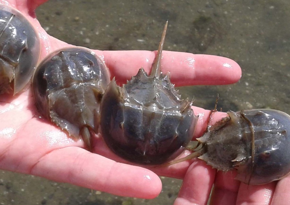


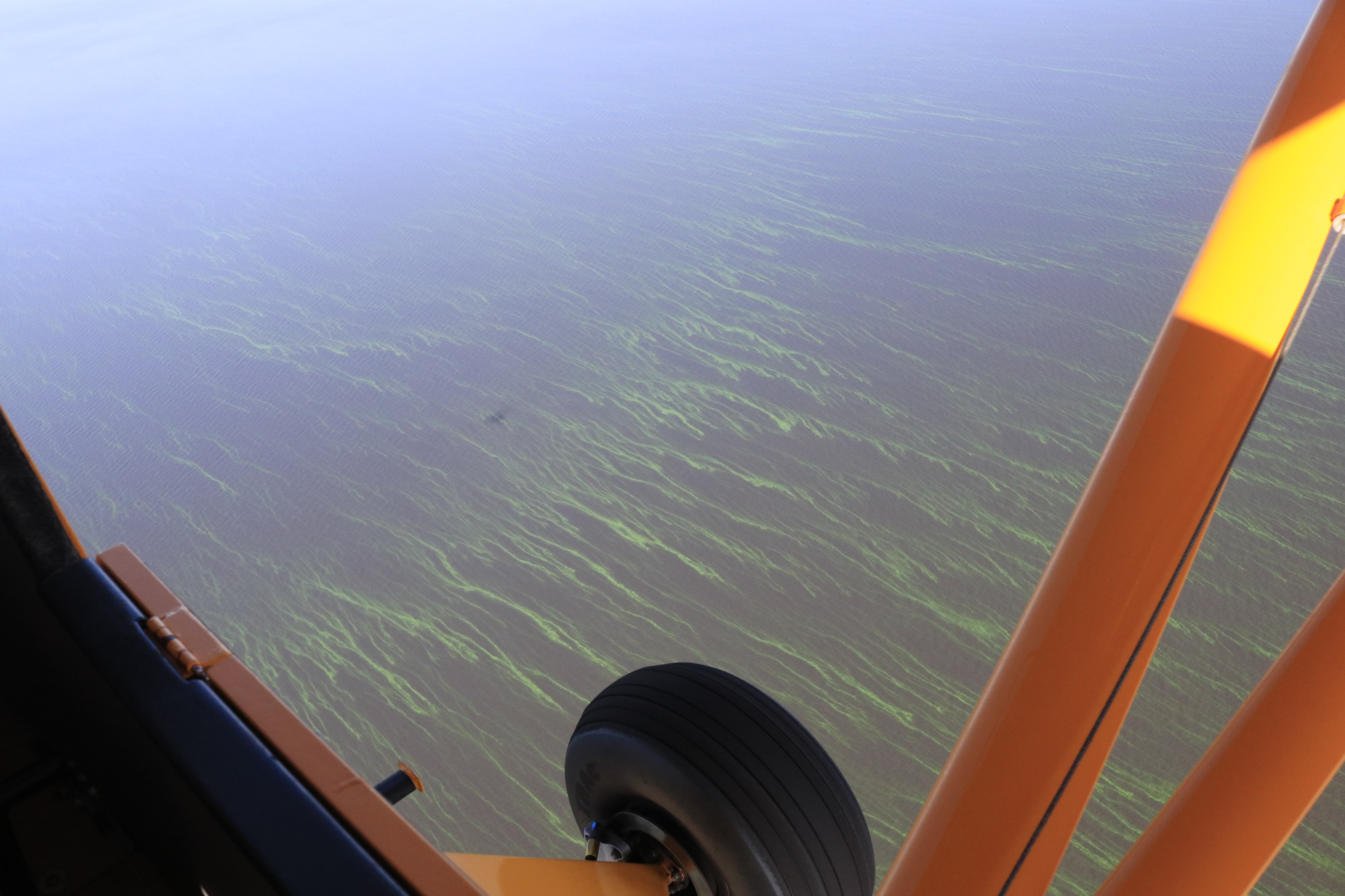


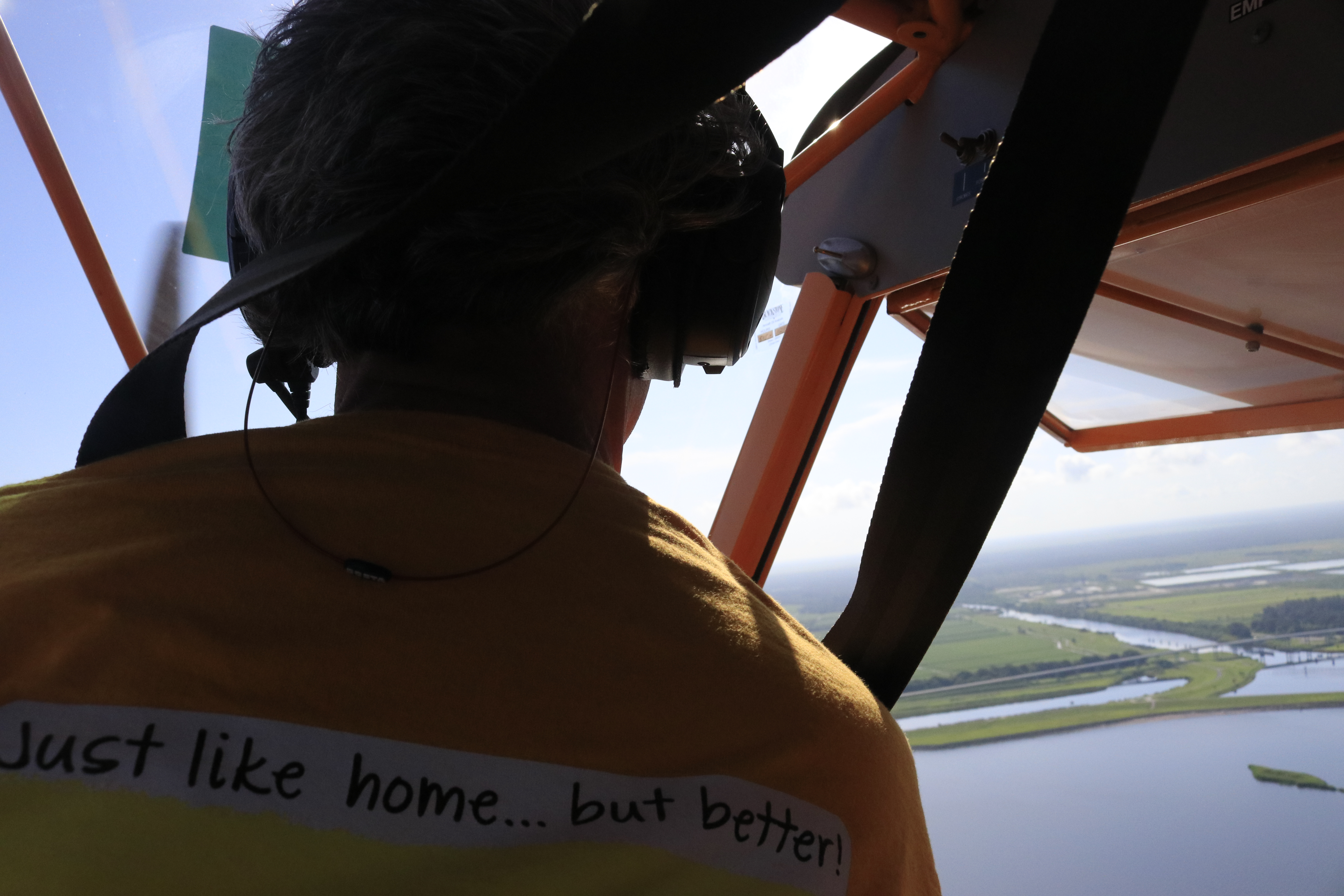


