Tag Archives: Dupuis

LakeO Update Sunday, July 5, 2020

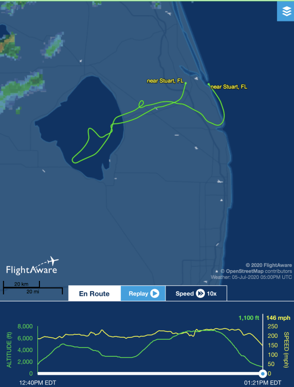
Keeping up the Lake Okeechobee algae bloom documentation, Ed and I flew from Stuart to Lake Okeechobee during a hazy, hot high-noon, on Sunday, July 5, 2020. The algae was much toned down from our previous flights in June. Nonetheless, one could see the pattern, the outline, of the giant bloom from above. Rain may have disrupted its perk but the bloom remains in the water column. The most visual appeared to be in the middle of the lake and again, about a mile or so off Port Mayaca. 

I have included photographs of the journey: St Lucie River at Palm City; flying over western lands and under construction C-44 Reservoir/STA ; FPL cooling pond; algae in Lake O; Clewiston; south rim of lake with agriculture and sugar fields; Indiantown and Hwy. 710; DuPuis and Corbett Wildlife Areas;  one glance back to Lake Okeechobee; and an updated 2020 “Covid-19 portrait” of Ed and me. 

We will continue to document throughout the summer. Keep up the fight! Stop the Discharges! Stop the Algae

~Your eye in the sky

Jacqui & Ed 

St Lucie River at Palm City
Western lands and C-44 Reservoir/STA under construction-5 STA cells  filled
FPL cooling pond and edge of LO
Algae in LO off Port Mayaca
Closer to center of LO

Clewiston
Southern shoreline and agriculture fields, mostly sugarcane
Southeastern shoreline
Port Mayaca, DuPuis, Corbett Wildlife Management Area-dark green

This shot, below, was taken flying back east over the Village of Indiantown. Highway 710 is seen bisecting neighboring Dupuis and Corbett Wildlife Area and John and Mariana Jones Hungryland Wildlife Area. I will be writing more about the protected areas and the highway that cuts through them in the future. 

“Hey get rid of that plastic water bottle would ya? 100 degrees or not!” Jacqui & Ed 2020

The Line Between Past and Present: Corbett Wildlife Area, SLR/IRL

Ed looks outside the plane: a  “line” divides agricultural fields and the wetlands of J.W. Corbett Wildlife Area. 7-8-17.

An overview…
Sometimes it seems there is not a piece of land that doesn’t have the mark of modern-humans on it…but then, we have been leaving our mark for thousands, and thousands of years…

On a recent trip with renowned South Florida photographer Edward Carr, my husband Ed and I flew over the contiguous Dupuis and J.W. Corbett Wildlife Areas ~ “bordering” Martin and Palm Beach counties.

It was quite a view, and I felt embarrassed that I did not know more about these wonderful remaining lands located so close to home. So interesting to see them in a more natural state. The circles of trees, dome-like, standing in shallow water. Shades of green, brown, and blue changing and reflecting with every turn. An animal running into the bush. What was it?! A deer? A panther?

I have to admit, chasing toxic algae sometimes overtake me!.. I must remind myself  “to stop and smell the pond apples!”

Pond apple blossom. Photo by Lisa Jefferson. There was a 32,000 acre pond apple forest on the Southern rim of Lake O prior to development.
Mr Carr was photographing for a documentary on “Big Mound City” the most remarkable of places our human ancestors called home. These native people of Lake Okeechobee’s Belle Glade Culture, built mounds to get above the swamp rather than trying to drain it….as sea level rises, we many have to consider this once again just like the FEMA project in Sewall’s Point!

I find this entirely fascinating…history repeating itself…

I tried to get Ed later in that week to go with me into Corbett for a hike and to explore, but he said it’s too hot right now, he rather fly. It would be “torture in there.” Well, when the weather cools down, I am taking him. What a wonderful piece of natural history to have right in your own back yard.

LINKS:

FWC JW CORBETT: http://myfwc.com/viewing/recreation/wmas/lead/jw-corbett

BIG MOUND CITY: http://myfwc.com/viewing/recreation/wmas/lead/jw-corbett/history/

DUPUIS, SFWMD: https://www.sfwmd.gov/recreation-site/dupuis-management-area

The L-8 Canal runs through Corbett: http://www.dep.state.fl.us/southeast/ecosum/ecosums/l-8.pdf

L-8 & C-51 Reservoir etc: http://my.sfwmd.gov/webapps/publicMeetings/viewFile/8656

Interestingly, Sirkorsky is located in J.W. Corbett: http://lockheedmartin.com/us/what-we-do/aerospace-defense/sikorsky.html

Flight path

Google Earth Dupuis and JW Corbett just east of Lake O and south of FPL reservoir

A view from above

Agriculture fields meet JW Corbett

Edward Carr