On Tuesday, I will raise my right hand on the steps of Florida’s Historic Capitol to take the oath of office in much the same tradition that 45 governors have before me. With my wife, Casey, and our two young children, Madison and Mason, watching, it will be a pointed reminder that to whom much is given, much is required. ~Governor-Elect, Ron DeSantis
Casey and Ron DeSantis. He holds a River Kidz workbook. River Kidz LJ Leighton (pink shorts), Keile Mader also holding book. Carley Collins, Jack Maldonado Benson, Carter Streiber and Congressman Brian Mast, St Lucie River Tour
Tomorrow at 11:00 am, Ron DeSantis will be sworn in on the Capitol steps as the 46th Governor of the State of Florida. I met him once. The date was August 20, 2018 and he and his wife Casey, had come to Stuart to see the toxic-algae water problems for themselves. A boat tour had been arranged by Congressman Brian Mast’s office. The water was a disgrace, all explained why….
Ron and Casey DeSantis were attentive listeners, and took seriously the plight of the St Lucie River. They have young children of their own. Just a few days ago, DeSantis, wrote an op-ed referring to his experiences along the rivers of St Lucie and Calooshahatchee. I believe the tour and the words of the River Kidz had an effect, read below, and I know the kids too will be watching not just DeSantis but what all of us do…
“I will fulfill promises from the campaign trail. That means prioritizing environmental issues, like water quality and cleaning the environmental mess that has resulted in toxic blue-green algae and exacerbated red tide around the state. We will put Everglades restoration into high gear and make it the reality that Floridians have been promised for three decades.” Ron DeSantis, Governor Elect ~Full text, Tallahassee Democrat: https://www.tallahassee.com/story/opinion/2019/01/04/im-committed-pursuing-bold-agenda-florida-ron-desantis/2481606002/)
“Happy your’e here; not happy about the algae!” the River Kidz arrive to meet the DeSantises with River Mom, Cristina Maldonado, River Granny JTL, and Congressman Brian Mast.
Meeting the kidz Joe Negron and Stephen Leighton show Governor-elect DeSantis and Congressman Mast Brain Mast blue green algae in Shepherd Park
12-4-17, ca. 2:45 pm, photos: Ed Lippisch & Jacqui Thurlow-Lippisch
The Army Corp of Engineers has lessened but not stopped Lake O discharges that started September 20th, 2017 just prior to Hurricane Irma. Perhaps as the discharges have gone on at such a high rate for a comparatively long time, the plume has had a chance to extend its territory. In yesterday’s photos, the dark, filthy plume is reaching clearly south beyond the exclusive Town of Jupiter Island.
Yesterday was a beautiful day, but the river and ocean waters of our entire region were ugly, possibly contaminated. How are we to enjoy our property and lives here?
When viewing the aerials below, please note the blue, sapphire-colored water just on the edge of the discharge plume. Yes, of course all estuaries put forth darkened fresh water after a rain event, and Ed and I could see this occurring just south at Jupiter Inlet. Nonetheless, the black, gigantic plume that we repeatedly endure for the St Lucie River/Indian River Lagoon due to discharges from Lake Okeechobee is an aberration.
Please let’s all support Joe Negron and the public’s work to build the EAA Reservoir; clean & send the water south!
Lake O discharges: http://w3.saj.usace.army.mil/h2o/reports.htmLooking south along the southern most area of Jupiter Island.Looking north along Jupiter Island-dark ocean waters. Jupiter Narrows an extension of the IRL on left.Plume -looking north along Atlantic coastEdge of plume; note clean sapphire colored water juxtaposed to dark Lake O/canal plumeAnother angle, Jupiter Island, looking south-blur due to wind and camera movementBack at St Lucie InletIRL, note bare bottom. This area is known as the Sailfish Flats and once had hundreds of acres of seagrass beds.The Sandbar, a popular weekend recreational area for boaters, especially families, surrounded in dark Lake O discharge waters. This is a health issue.Barren Sailfish FlatsSand bottom with no seagrass between Sewall’s Point and Sailfish Point. An area once teaming with life.The Crossroads — no seagrass beds just sand bottomIRL looking northSt Lucie River near St Lucie Inlet dark as coffeeNorth of St Lucie Inlet the plume covers near shore protected reefs as it does south of the inlet.Blue!The plume as viewed from under the wing of the CubPlume edge: The tainted water we are given by our government; the blue –the water we should have by God & Nature.
A lone sailboat is a sea of blackness, confluence of the St Lucie River/Indian River Lagoon, once considered the most biodiverse estuary in North America and full of seagrasses, a nursery for the ocean..http://w3.saj.usace.army.mil/h2o/plots/s308h.pdfI am very fortunate to have a small army of people helping me document the Lake Okeechobee discharges this year. Presently, it is the tremendous rate of government sponsored discharge from Lake O that is destroying the regions’ economy and ecology, right before our eyes, ~once again.
Friends of my husband, pilots Dave Stone and Scott Kuhns, took these aerials yesterday, 11-8-17 around 5 pm. When I asked Scott about the plume, he relayed that it went 15 miles south almost all the way to Jupiter Inlet, and since there is also rain driven, fresh, dark- stained water flowing out of the Jupiter Inlet (not over-nutrified, black-sediment water from Lake O) there was no clear delineation of blackened plume to aqua ocean water, like usual–rather, the waters are all dark….
“How far did the plume go east from the St Lucie Inlet?” I asked. “From the coast, as far as the eye could see…”
End of plume, near Jupiter InletAnother angle end of plume near Jupiter InletUp close of a boat in the plume. Look at the sediment! Covering what once was seagrasses and killing our near shore “protected” reefs.Plume in black water. Brown on black. The ocean? You’d think it was an oil spill.Plume as seen at mouth of St Lucie Inlet near multi million dollar homes in Sailfish Point.Plume at mouth of St Lucie Inlet on south side as seen against Jupiter Island’s state park/Jupiter Narrows.A lone sailboat is a sea of blackness, St Lucie River/Indian River Lagoon, once considered the most biodiverse estuary in North America and full of seagrasses, a nursery for the ocean.Plume exiting St Lucie InletThe north Jetty at the St Lucie Inlet with plume waters going into the Atlantic Ocean. The plume goes east for many miles.
*The ACOE has been discharging from Lake O since Hurricane IRMA hit on Sept 2oth, 2017. The rate of discharge has gone up and down, however increasing over recent weeks. Word is the St Lucie could be dumped on for many more months, possibly through the end of the year. So don’t count on taking your visiting relatives out fishing this holiday season even though you moved here for the water. This ecological disaster is finally seeing light at the end of the tunnel as Senator Joe Negron, alongside the public, and “River Warrior” groups, particularly Bullsugar, has pushed so hard that the SFWMD and ACOE are finally working towards building an EAA Reservoir that will begin the long journey of changing water drainage culture in South Florida, and “sending the water south.” Please get involved and learn more by viewing this SFWMD EAA RESERVOIR website:https://www.sfwmd.gov/our-work/cerp-project-planning/eaa-reservoir
*Thank you to the people, and the children, groups such as the C4CW, Rivers Coalition, grandparents’ HOA email chains, leadership at Martin Health System, and to the those working for the agencies trying to help the St Lucie. As the River Kidz say:
Tonight I am speaking for the first time in public as a commissioner of the 2017/18 Florida Constitution Revision Commission. I have been invited to present to the Martin County NAACP. Everyone is invited. I am very excited about this, and am sharing my notes so others who may not be able to attend can also be part.
As this entire process is “historic,” I have decided to include this experiences on my blog. Please note this post is “in the Sunshine,” will be archived in my CRC email, and open to the public. All comments made will be public record.
CRC 2018NOTES FOR NAACP/CRC TALK 6-15-17
I am proud to present to the Martin County National Association for the Advancement of Colored People. Getting involved in Florida’s 2017/2018 Constitution Revision Commission process will be rewarding!
My name is Jacqui Thurlow-Lippisch. My family has been in Stuart since 1952, and I was part of the first desegregated class to attend Stuart’s Parker Annex, known today as J.D. Parker Elementary. I have many friends in Stuart’s black community; I graduated from both Stuart Middle School and Martin County High School. After graduating from the University of Florida and University West Florida, I worked as a public school teacher and as a real estate agent.
In 2008, I ran for public office, and after a decade of pubic service as mayor/commissioner of Sewall’s Point, (as well narrowly losing a race for Martin County Commissioner in 2016) I was chosen by Senate President Joe Negron to serve on the 2018 Constitution Revision Commission, or “CRC” for short. Quite an honor! I am very thankful to Senate President Joe Negron for giving me this opportunity to serve the people of Florida and expand my experience.
Today my goal for you is to briefly cover the CRC’s history; discuss the CRC “today;” and review how to submit a proposal to the CRC for consideration to go before the voters as a constitutional amendment, on the ballot, in November 2018.
The handouts cover much more material than I will be able to cover in the next thirty minutes and are excellent resources.
BRIEF HISTORY
The history of the Florida constitution is the history of Florida itself.
I recommend two books: Making Modern Florida, by Mary E. Adkins, and The Florida State Constitution, 2nd Edition, by Talbot “Sandy” D’Alemberte. Both are great resources on this subject.
The books discuss:
Florida as a territory and entering the union as a slave state in 1845; succession from the Union in 1861, military occupation following the Civil War; the finally “recognized” constitution of 1885 (and its many others!); overcoming the power of the “Pork Chop Gang”; Reapportionment; and the landmark case of 1962, Baker v. Carr enabling U.S.Federal Courts to intervene in the voting boundaries of the states…
This did happened in 1966, leading to upheaval and redistricting, creating “modern Florida” and its 1968 constitution that is the basis of Florida today.
So what is the CRC and why does it exist? Why does it happen only every 20 years?
Professor D’Alemberte notes with all the political and social instability of the 1960s, it was born…
“in 1965 every effort was made to revise Florida’s constitution when the legislature enacted a statutory CRC, and in 1968 the new constitution had substantial changes relating to the amendatory process. In addition to the two traditional methods of constitutional change: constitutional convention and legislative proposals, the 1968 document added the process of the independent Constitution Revision Commission.“
Chair off the 1968 commission, Chesterfield Smith, stated:
“It is my own personal judgement that above all other matters, the new provisions in the 1968 Constitution authorizing means for further constitutional law changes are the most important things in the new constitution.”
The state never wanted to be in a position again like it was in the 1960s having the federal government tell it what to do…
So since 1968, every twenty years, there is the possibility and encouragement, if needed, for constitutional change through the CRC process, so that the voices of the people will be heard and recorded.
(Yes there are other ways too, but this is the most direct, in that amendments go directly on the ballot.)
The CRC is made up of 37 people. 15 are chosen by the Governor; 9 by the President of the Senate, 9 by the Speaker of the House; and 3 by the Chief of the Florida Supreme Court; the Attorney General is automatically a member. The chair, one of the governors’ 15, is Mr Carlos Beruff.
Let’s look at the diversity of the members:
I think it is a good representation for Florida, however, it must be noted that the commission like Tallahassee right now, is predominantly republican.
We can see there are 22 men; 15 women; 14 minorities. Other notes include 14 attorneys; 5 legislators; 3 former senators, 1 former house representative; 5 other elected officials such as sheriff, clerk, county commissioner, school board member and attorney general; at least 10 educators; including business owners and 3 developers.
Over the past few months, the commission has held numerous public hearings entitled “listening tours” across the state and during this time the public has proposed over 400 unique proposals and 900 all together!
CRC 2018I will read some of the topics that have come up and the order they were presented during one of the listening tours. Please note I am not going to say if I am for or against. This is just to share so you have an idea of what’s coming up. You can watch all of the hearings on the Florida Channel: http://thefloridachannel.org
Ready?
~Voting rights for ex. felons; Amd. 1 Art. 23, privacy and abortion; Legislature’s failure to implement the 2014 citizen’s initiative, Land and Water Legacy; open primaries; issues with write in candidates; insuring veteran’s health; clean water and air as a right; more solar energy; gun rights; gun control; transparency in government; equal rights amendment; right to assisted suicide; right to life; bear hunting; fair districts; non discrimination; independent redistricting; universal background checks/guns; home rule and local government; school choice; support of public schools; term limits for judges; no term limits for judges; cruelty to greyhound dogs/no racing…there are many more!
SUBMITTING A PROPOSAL
In closing, I will share with you how you can submit a proposal and am happy to answer any questions.
An excellent and easy way to submit a proposal is on-line: (above)
Just fill out the requited fields and walk through the prompts; you can practice before you publish.
Obviously you must be familiar with state constitution and the area of the constitution that refers to your topic/proposal, or would if it were there. The Constitution can be read by Article on the site or here: http://www.leg.state.fl.us/statutes/index.cfm?submenu=3
Second, ask yourself what would this change look like in the constitution itself? The wording? After finding the Article and Section, you will insert, and or redact language for your final product.
So proposals can be submitted on-line, emailed; US mailed, or turned in by hand at a public meeting.
Once committees are in place, all proposals will be referred to the correct committee and here it will be determined if the proposal will go before the entire commission for a vote.
So far there are more proposals than 1978 or 1998 and we are far from the finish line!
To give you an idea of past approval numbers: 1998 CRC, nine constitutional amendments went on the ballot and eight were voted and approved by the public to go into the Florida Constitution. 1978 CRC, not one put on the ballot made it. Back then the threshold was 50%; today it is 60%. The Constitution should not be changed easily!
You, the voters, will decide!
So thank you again, get involved and know I am here to help you with the process of making sure your voice is heard and Florida’s constitution is relevant, living and real.
Award winning conservation, hunting and fishing journalist, Hal Herring over S-308, the connection from Lake Okeechobee to canal C-44 and the St Lucie River/IRL, JTL 5-13-17Award page Hal Herring, from his web site
At the recent Bullsugar “Fund the Fight” event, Captain Mike Connor introduced me to Montana based, award-winning fishing and hunting journalist, Hal Herring. I looked Hal straight in the eye, shook his strong hand and said, “It’s so nice to meet you Mr Herrington.” He smiled, eyes sparkling, and replied, “Herring mam. Like the fish.”
Fly Life Magazine writes: “Herring, one of the leading outdoor writers of our time, co-manages the Conservationist Blog for Field & Stream, is the author of several books and is a regular contributor to numerous other well-known outdoor news outlets including High Country News, Montana’s Bully Pulpit Blog and the Nature Conservancy magazine.”
To say the least, I felt honored to be chosen as a tour guide for Hal Herring as my husband and Mike Connor arranged an aerial journey for the visiting journalist. After researching Hal, checking out his website, and reading his article on the Clean Water Act, I knew I was dealing with a gifted journalist. What a great person to have learn about the problems of our St Lucie River!
Hal Herring and JTL, Baron’s back seatContemporary Florida canal map ACOE/SFWMD1839 military/Everglades mapDan, Ed, Hal and JTLCanals C-23, C-24, C-25 and most southerly C-44 connected to Lake Okeechobee.
We prepared the Baron for Saturday. My husband Ed invited friend and fellow fisherman Dr Dan Velinsky. The flight stared with a rough take off. I steadied myself. “Please don’t let me puke Lord…” As Ed gained altitude, things settled down and we were on our way…
After taking off from Witham Field in Stuart, we followed the dreadful C-44 canal west to Lake Okeechobee; diverting north at the C-44 Reservoir under construction in Indiantown; traveled over the FPL cooling pond and S-308, the opening to C-44 and the St Lucie River at Port Mayaca. Next we followed Lake Okeechobee’s east side south to Pahokee, and then Belle Glade in the Sugarland of the EAA; here we followed the North New River Canal and Highway 27 south to the lands spoken about so much lately, A-1 and A-2 and surrounding area of the Tailman property where Senate Presidient Joe Negron’s recently negociated deeper reservoir will be constructed if all goes well; then we flew over the Storm Water Treatment Areas, Water Conservation Areas, and headed home east over the houses of Broward County inside the Everglades. Last over West Palm Beach, Jupiter, north along the Indian River Lagoon and then back to the St Lucie Inlet. Everywhere the landscape was altered. No wonder the water is such a mess…
See red triangle left of right circle. This area of A-1 and A-2 and the reservoir is to be located on top of and closebyOld orange grove being made into the C-44 Reservoir/STA, IndiantownFPL cooling pond on edge of Lake O, IndiantownS-308 at Lake O, Port MayacaOver Lake OA-1 and A-2 area, southern EAA with WCA on leftEdge of Conservation areas next to A-1 and A-2 areasBroward County built into EvergladesAlong the SE coast looking south, FPL’s St Lucie Nuclear Power PlantMartin County, St Luice Inlet
I explained the history, Dan told fish stories, Ed ducked in and out of clouds. All the while, Hal Herring took notes on a yellow legal pad with calmness and confidence. Nothing surprised him; he was a quick study in spite of all the variables. He was so well read, not speaking often but when he did, like a prophet of sorts. He spoke about this strange time of history, the time we are living in, when humans have overrun the natural landscape. He spoke about mankind being obsessed with transcending the limits of the natural world…and the control of nature…but for Hal there was no anger or disbelief, just wisdom. In his biography, he says it best:
“My passions as a writer and storyteller lie where they always have – in exploring humankind’s evolving relationship to the natural world, and all the failures, successes and deep tensions inherent in that relationship…”
In the Everglades region, Hal may just have hit the jackpot!
Today I am again honored to feature the writing of Professor Geoff Norris. This most recent work is a tremendous achievement of time, research, and puzzle piecing. Professor Norris’ past shared articles “Blue Green Algal Blooms in the Lakes, Rivers, and Marine Waters of South Florida Surrounding Lake Okeechobee,” and “Sugarcane and Indians” were extremely popular with many of my readers. Professor Norris has a way of communicating complex topics in an easy and interesting way so that everyone can understand and make the connections. In the 1960s Professor Norris lived and worked as a petroleum exploration geologist in Tulsa, Oklahoma. Subsequently, he spent 40 years at the University of Toronto teaching and performing research in geology. A geologist by training, Professor Norris has a specialized knowledge of fossil algae, their ecology, morphology, and distribution. He has published hundreds of scientific papers on fossil algae and related topics…I encourage you to contact him by email with any questions at rosalex@interlog.com
Thank you Professor Norris. “Together we will create a “better water future!”
Jacqui
Lake Okeechobee blue-green bacterial blooms in Florida: lessons from Lake Erie
In the following article, I have attempted to summarize some of the voluminous literature on Lake Erie and its problem blue-green blooms, and how this might help to understand similar events in Lake Okeechobee. I have included URL web addresses for some of the topics, which can be used to access further information.
Although the blooms are often referred to as blue-green algae, this is quite inaccurate and I can see no further point in perpetuating this misnomer. The blooms are largely or entirely composed of Cyanobacteria, or blue-green bacteria as I have chosen to call them for this article. This is not just for precision and to point up their lack of a nucleus and other organelles in each cell, but serves to underline how these organisms earn a living and perpetuate themselves that is quite different compared to nucleated organisms, the latter including algae, fungi, all green plants, and all animals. This difference is really important.
The topic is vast and my review barely scratches the surface – it’s not meant to, because I am not an expert and am still trying to understand the vast complexity of blue-green bacterial bloom formation. I have tried to unravel and clarify some of the science and scientific investigations that have been important for me, and have used these as examples of the work that is going on or has led to current advances. For every paper I have cited, however, there could be tens or hundreds more that haven’t been consulted or mentioned. I apologize in advance to those many talented scientists that I haven’t mentioned or that I am simply unaware of.
Steel Town
I used to live in Hamilton, Ontario, a prosperous city with thriving iron and steel mills, other manufacturing industries, an excellent university and a great football team, a sort of Pittsburg of the North. It sits on the shores of Lake Ontario on a sliver of land – the Niagara Peninsula – that separates Lake Erie from Lake Ontario. In the early summer after the ice had melted, many of the locals in the mid-1900s would take advantage of the beaches along Lake Ontario to sun themselves and wait until the water was warm enough to swim in. However, you could get a head start on summer by taking a short drive south (less than an hour) to the beaches along Lake Erie where the water was warmer earlier in the summer, and resorts and tourism thrived. Fish were abundant and the lake was very productive for commercial fishing and equally attractive for sport fishing. The beaches were superb for tourism and sun lovers. Lake Erie is large but shallow (average depth about 60ft) and so a baby on a Great Lakes scale from a volumetric point of view (most of the Great Lakes are hundreds of feet deep, the deepest being Superior at more than 1300 ft maximum depth). However, Lake Erie’s smaller volume and shallow waters helped it to warm up quickly in the spring and summer.
The Dead Sea of North America
Then something happened to Lake Erie, starting in the 1960s. The water of Lake Erie became murky and discolored, mass fish kills led to piles of rotting marine life polluting the beaches, the tourists and anglers and sun worshippers stayed away in droves, the resorts closed down, the commercial fisheries were badly hit, and the economy suffered enormously. Algae were blamed but no one was quite sure why they had become so abundant – “eutrophication” was the buzzword of the time. Lake Erie was declared “dead”, which was quite inaccurate since it was swarming with life, but the wrong sort of life. The culprits polluting the environment were a mixture of true green algae (such as Cladophora) and so-called “blue green algae” (such as Microcystis and Aphanizomenon), which in truth are types of bacteria using chlorophyll and other pigments that allow them to live in sunlight (their technical name is Cyanobacteria –called blue-green bacteria in this article), and this is discussed in more detail in my previous blog: https://jacquithurlowlippisch.com/tag/dr-geoffrey-norris/). The plight of the Dead Sea of North America (as Lake Erie became known) was so notorious that one of Dr Seuss’s books for children – The Lorax (1971) – made reference to it in his famous style of doggerel:
You’re glumping the pond where the Humming-Fish hummed!
No more can they hum, for their gills are gummed.
So I’m sending them off. Oh, their future is dreary.
They’ll walk on their fins and get woefully weary
In search of some water that isn’t so smeary.
I hear things are just as bad up in Lake Erie.
The Fix
Very fortunately the mystery of Lake Erie’s “death” was soon solved, thanks to a treaty between the U.S. and Canada dating back to the early 1900s that acknowledged the need to maintain water quality in the Great Lakes’ waters bordering the two countries.
By the middle of the 20th century this had morphed into the International Joint Commission for the Great Lakes. These international efforts were underpinned by government and university-based research in both the U.S. and Canada, which identified phosphorus entering the waters as a major contributor, particularly from agricultural fertilizers on the one hand and from domestic laundry detergents on the other. In 1972 the Great Lakes Water Quality Agreement (GLQWA) was signed between the United States and Canada, by Prime Minister Pierre Trudeau for Canada and President Richard Nixon for the United States. They loathed one another personally, but they knew what was the right thing to do for their countries.
Prime Minister Pierre Elliott Trudeau and President Richard Nixon signing the Agreement.
The Agreement emphasized the reduction of phosphorous entering lakes Erie and Ontario, and, in 1977, maximum levels for phosphorous were added to the Agreement. Also, phosphorus in laundry detergents was finally drastically reduced or banned. Coupled with the U.S. and Canadian Clean Water acts, the International Joint Commission did much to reduce the phosphorus levels in Lake Erie.
International Joint Commission (IJC): “More than a century of cooperation protecting shared waters. Canada and the United States each appoint three of the six IJC Commissioners, including one chair from each country. The two chairs serve concurrently.The Commissioners are appointed by the highest level of government in each country, but once appointed they do not represent the national governments; they operate at arm’s length.The Commissioners traditionally work by consensus to find solutions that are in the best interest of both countries. The Commissioners are supported by U.S. and Canadian Section offices in Washington, D.C. and Ottawa, Ontario.”
So everyone breathed a sigh of relief, phosphorus levels went down, farmers applied fertilizers to their fields differently, consumers chose phosphorus-free detergents, municipalities improved their storm water and sewage treatment facilities, the fish and other wildlife came back to Lake Erie, and Dr Seuss was persuaded to remove the last line in his poem. Further details can be found in a report by the National Wildlife Federation:
For almost 20 years, Lake Erie was not plagued by the blue-green bacteria problem, but other problems did emerge such as exotic zebra mussels that interfered with the distribution of elements important in nutrition, but they seemed at the time to be unrelated to bacterial infestations. Then starting in the mid-1990s, the blue-greens reappeared and became progressively worse leading to super-gigantic blooms that choked the western end of Lake Erie with green muck inches thick and hundred of square miles in extent. Dead zones – biological black holes – reappeared in the Lake as the rotting organic matter sucked the oxygen out of the water, promising certain death to animals that ventured in.
In the summer of 2011 the mother of all blue-green bacterial blooms exploded in Lake Erie, the bloom at its peak being more than 1900 square miles in extent. That is more than 50% greater than the entire state of Rhode Island, or 35% larger than Long Island, or more than six times larger than all of New York City’s five boroughs. This super-giant bloom had an estimated weight of 40,000 metric tons dry weight. The wet weights of algae and blue-green bacteria are generally at least 10 times the dry weight. So, this supergiant bloom had at least half a billion tons of blue-green bacteria living within it – a true monster.
MODIS (Moderate Resolution Imaging Spectroradiometer) satellite Image of Lake Erie on September 3, 2011, overlaid over map of Lake Erie tributaries. This image shows the bloom (in green) about 6 weeks after its initiation in the western basin. From Michalak et al, 2013.
These blooms had a devastating effect on the areas flanking the western end of Lake Erie – Ohio, Michigan, and Ontario – with large agricultural areas and several major cities and industrial towns. Toxins from the blue-green bacteria polluted the drinking water supplies of large cities, and potable water had to be trucked in for the residents.
The “greening” of Lake Erie has been documented by Prof. Tom Bridgeman of the University of Toledo in a presentation:
In his presentation Prof. Bridgman showed how increasing phosphorus in the lake water favored the blue-green bacteria and shut out the normal tiny floating plants (true algae), a situation that had culminated in the American Dead Sea catastrophe of the 1960s. The international agreement on phosphorus reduction in the Great Lakes was a huge success story for Lake Erie, but by the mid 1990s algal biomass was beginning to increase again (eutrophication was returning), and by the early 2000s blue green bacteria such as Microcystis were increasing ten-fold, as the reactive phosphorus in the lake waters increased beyond levels recorded in the 1970s.
What the heck was going on here? Everyone had played their part in reducing phosphorus run-off from agricultural lands, and the municipalities and citizens had cleaned up their act. So where was the phosphorus coming from? Well now the plot thickens.
Farming and Phosphorus
This time, the main problems are thought to be ones that governments have much less direct control over, according to a file posted by Emily Chung of the Canadian Broadcasting Corporation News (2014).
To some extent, they include the application of fertilizers to lawns and golf courses, growing expanses of pavement in urban areas that cause water to drain more quickly into waterways without being filtered by vegetation, and invasive zebra mussels that release extra nutrients into the water as they feed. But those aren’t thought to be the biggest cause.
“We think farming is the major culprit behind the current levels of phosphorus that’s in runoff and the phosphorus loads that are getting dumped into the western basin of Lake Erie,” said Dr. Glenn Benoy (senior water quality specialist and science adviser with the International Joint Commission in Ottawa).
Dr Glenn Benoy
So why is this? Well, there are several things going on. Firstly, corn production is at an all time high because of the push to increase alcohol biofuel production, and soybeans are being produced in gigantic quantities for use as animal feed, oil and protein for human consumption, plastics and biodiesel. Secondly, the introduction of no-till farming practice in the U.S. has led to increased run-off of fertilizer. Thirdly, there’s just not enough infrastructure to deliver in the spring the huge amounts of fertilizer that are required by the corn farmers. Prof. Ivan O’Halloran of Guelph University, Ontario and a specialist in soil fertility and nutrient use commented that the demand by corn farmers is such that there are simply not enough rail cars to satisfy the need. So companies offer discounts to farmers who are willing to apply fertilizer in the fall, which in turn leads to enhanced run-off of phosphorus during the winter storms.
Prof. Ivan O’Halloran
No-till Farming and Glyphosate
And then there is the matter of no-till farming. No-till farming (also called zero tillage or direct drilling) is a way of growing crops or pasture from year to year without disturbing the soil through tillage, and in current practice depends on the use of powerful herbicides such as glyphosate (Monsanto’s Roundup brand being the most popular formulation). Application of glyphosate kills weeds and other vegetation in preparation of the seedbed. Later in the year, another application of the herbicide is used to reduce weeds that might be harming the crop. However, this is only possible if the farmers use genetically modified seeds that are resistant to glyphosate – often referred to as Roundup Ready seeds. In 2014 in the U.S. 98% of soybeans and more than half of corn was Roundup Ready. Advocates of Roundup point out that glyphosate is a compound derived from phosphonic acid in which the phosphorus is strongly bonded to carbon and therefore is not available to plants, unlike fertilizer which contains phosphates (not phosphonates) which has phosphorus bonded less strongly to oxygen, and is therefore more readily available for uptake by plants (often referred to by the acronym DRP – dissolved reactive phosphorus).
Prof. Chris Spiese is a chemist at Ohio Northern University and he decided to test the contribution that glyphosate might make to the amount of dissolved reactive phosphorus running off of cultivated fields. He found that glyphosate acts on the soil to allow the phosphorus bonded to the soil (either being naturally present or due to fertilizer use) to be released by the chemical process known as desorption. He also found that soils richer in both iron oxides and iron hydroxides tend to release by desorption more phosphorus, as do soils that are more acidic. Overall, he calculated that glyphosate is responsible for releasing 20-25% of the dissolved reactive phosphorus in the Maumee watershed, a river discharging into the western end of Lake Erie. Prof. Spiese calculated that for every acre of Roundup Ready soybeans, one-third of a pound of phosphorus comes down the Maumee River. In 2010, according to the Ohio Soybean Council, 4.6 million acres were planted in soybeans, of which about 2 million acres of soybean fields drain into Lake Erie.
If Prof. Spiese’s calculation for the Maumee watershed hold true for all the soybean acreage in Ohio draining into Lake Erie, this would suggest that each year hundreds of tons of dissolved reactive phosphorus are entering the Lake from this source alone. And then there are the other states and provinces bordering Lake Erie that are also involved in soybean production: Ontario 2 million acres; Michigan 1.5 million acres; NW New York, 1/3 million acres; Pennsylvania 1/2 million acres. Of course, not all these agricultural lands drain into Lake Erie but these numbers give some idea of potential dissolved reactive phosphorus input related to soybean production alone.
The Monster Revisited
The super-giant blue-green bacterial bloom of 2011 in Lake Erie required a concerted response from the scientific community to understand just why this had happened. There was no doubt in scientists’ minds that dissolved reactive phosphorus as run-off from agricultural land was a major factor. But why should a super-giant bloom happen in 2011 and not in 2012 when the same agricultural land and its phosphorus run-off were still flanking the Lake and continued to be a constant factor? Something else was involved. So an elite team of scientists from universities, government laboratories, and industrial laboratories got together to investigate, headed up by Prof. Anna Michalak of Stanford University.
Prof. Anna Michalak
In 2013 this team of 29 scientists came up with their report, which was published in the prestigious Proceedings of the National Academy of Sciences.
The team concluded that long-term trends in agricultural practices (e.g. no-till farming) plus increased acreage under intense cultivation (notably soybeans and corn) led to a major pulse of phosphorus into Lake Erie during some unusually intense spring rainstorms in 2011. Then in the late spring and summer unusually quiet but warm weather conditions provided just the right conditions to seed, incubate and grow the bloom in the waters of Lake Erie. The team stated “If a scientifically guided management plan to mitigate these impacts is not implemented, we can therefore expect this [super-giant blue-green bacterial] bloom to be a harbinger of future blooms in Lake Erie.” – because unusual weather events, lower wind speeds, warmer waters, and higher rainfalls are becoming more common and can be expected in the future.
Glyphosate and Blue Green Bacteria
Recent work by scientists at Bowling Green State University has reported the presence of glyphosate in Lake Erie. It is evidently washing out of the no-till crop fields, and reaches a maximum in the summer months. Also it has been found in water treatment plants, peaking in the summer months. Prof. McKay and his colleagues raised the possibility in 2010 that the presence of glyphosate in Lake Erie together with phosphates from fertilizers tend to stimulate the growth of blue-green bacteria, whereas phosphates alone do not do this but favor diatoms, a normal algal component of Lake Erie. It seems that blue-green bacteria can utilize the phosphorus in the glyphosate, which was believed to be otherwise not normally bio-available. Many questions remain to be answered but the intense use of glyphosate in the area around Lake Erie demands rapid action in the very near future to establish just how much glyphosate is involved in blue-green bacterial blooms.
An even more disturbing piece of microbiological and genetic research was done by Prof. Victoria López-Rodas in Madrid together with other Spanish colleagues in 2007. They studied Microcystis, one of the bad boys of the blue-green bacteria family. They found that rare mutations during growth and division of cells could clone a glyphosate-resistant strain that could survive in glyphosate polluted waters. In other words, Microcystis has the potential to develop into a “superbug” unaffected by glyphosate. The odds of a mutation like this occurring were calculated to be a few times in 10 million by Prof. Lopez-Rodas’ team. That’s better than the odds for winning the Jackpot in the Florida Power Ball Lottery (1 in 292 million), but still not great. If you bought hundreds of millions of ticket in the lottery, you would have a good chance of winning at least once, perhaps several times (but at $2 a ticket you financial advisor might have some things to say to you about your investment strategy). However, given a little phosphorus and nitrogen, Microcystis can keep on dividing trillions and trillions of time to form blooms in warm water. With such astronomical numbers, a rare mutation becomes a virtual certainty at some point during cloning, and in the presence of an antibiotic such as glyphosate, a superbug is born.
So far the emphasis has been on phosphorus and how it is important in blue-green bacterial bloom formation. But nitrogen is also very important as a nutritional component for blue-greens and indeed for all life. Green plants need nitrogen to synthesize proteins and other important components in their cells. Although nitrogen is abundant in the atmosphere, it is an inert gas and simply unavailable as a nutrient for many green plants. It needs to be combined with hydrogen (as an ammonia compound) or with oxygen (as a nitrate compound) to be absorbed by the plant. These nitrogen compounds may be naturally occurring in soil, but in agricultural land they need to be added frequently as fertilizer for crops to thrive.
Blue-green bacteria have an advantage over green algae and other green plants because some blue-greens have the ability to synthesize nitrogen compounds directly from gaseous nitrogen – they are said to be able to “fix” the nitrogen. But some other blue-green bacteria are unable to fix the nitrogen and have to depend on another source. Microcystis is a case in point (the blue-green bacteria that are often dominant in the giant blooms in Lake Erie and Lake Okeechobee). Microcystis is highly dependant on a source of nitrogen to thrive. This can of course be provided by run-off from crop fertilizer, but it does not always explain the fluctuations of this and other blue-green bacteria that have or do not have nitrogen fixation ability in Lake Erie, in spite of the fact that the experts all agree that phosphorus – not nitrogen – is the principal limiting factor.
Lucas Beversdorf and colleagues at the University of Wisconsin decided in 2010 to try and solve the problem and improve predictability of toxic blue-green episodes in a beautifully designed and detailed study of Lake Mendota, Wisconsin a much smaller lake (15 square miles) than Lake Erie but about the same depth and with similar temperate seasonal weather patterns.
They found that Microcystis (blue-green non-nitrogen fixer) rode on the back of Aphanizomenon (blue-green nitrogen fixer) in a nutritional sense. Without the nitrogen fixer doing its work first in the spring, Microcystis as a non-nitrogen fixer could not attain dominance and pollute the water with toxic microcystin in the summer. This could be relevant to understanding how the blooms that occurred in the mid-20th century in Lake Erie came about, both Microcystis and Aphanizomenon being important contributors to large blue-green blooms at that time. It could also be important in predicting when blooms can be expected.
Prof. Karl Havens, a biologist at the University of Florida (and formerly of the South Florida Water Management District) has discussed the implications of nitrogen and phosphorus as nutrients for blue-green bacteria in Lake Okeechobee, and the need to reduce both given the physical and biological complexities in a shallow lake.
It has been known for some time that non-nitrogen fixing bacteria are highly competitive when it comes to ammonium compounds in freshwater lakes, possibly explaining why Microcystis and similar blue-green bacteria do achieve dominance in the blue-green blooms when in proximity to agricultural run-off.
Researchers are looking for ways to monitor assess and predict algal blooms of all types. This can be done by sampling the lake waters and analyzing them for various organisms and chemical compounds, such as Dr Beversdorf did for his detailed study of Lake Mendota. However, in very large lakes such as Lake Erie the shear size of the lake makes rapid response to a growing giant algal bloom impossible.
Prof. Joseph Ortiz of Kent State University, Ohio has been actively involved in developing new ways to gather information on giant blue-green bacterial blooms using an instrument on board the International Space Station. From space it can image all of Lake Erie in two days – remember Lake Erie is about 9,900 square miles (241 miles long, 57 miles wide). He uses a technique called hyperspectral visible derivative spectroscopy, quite a mouthful but very important. The hyperspectral imager works in orbit about 220 miles above the Earth’s surface and transmit the results to Dr Ortiz who uses sophisticated analytical methods to identify various types of algae and bacteria in the lake water.
This and related techniques are now being used to forecast blue-green bacterial blooms, in cooperative ventures between NASA and NOAA (National Oceanographic and Atmospheric Administration). For example this was their forecast summary for 2014:
“This year’s forecast is for a western basin Lake Erie cyanobacteria bloom of 22,000 metric tons dry weight (MT), with a 95% predictive interval of 11,000 to 33,000 MT. The bloom size over the last decade (2004-2013) has averaged 14,000 MT, such that this year’s bloom will likely be above average. However, the 2014 bloom is expected to be less than the record bloom of 40,000 MT, which occurred in 2011.”
In August of 2014 the City of Toledo shut down its water supply because of contamination by blue-green bacterial toxins (microcystin), which made it undrinkable for 400,000 residents, confirming the astonishing power of this predictive method.
A Florida Mismanagement Plan for Niagara Falls
Just imagine if the same planning “logic” had been applied to Lake Erie as has happened with Lake Okeechobee. In the case of Lake Okeechobee, agricultural interests took over an Everglades river and associated sawgrass wetlands to drain them for use as sugar plantations. To do this the ancient course of an Everglades river was disrupted by damming its 25-mile wide outflow from Lake Okeechobee, upstream from the Everglades Agricultural Area. In so doing the lake level rose because it had no other natural outlet. Therefore higher shoreline dike construction was needed (the Herbert Hoover Dike) to impound the water to prevent flooding of the adjacent land. All this destroyed a large part of the Everglades, a natural wonder of the world designated an International Biosphere Reserve and a World Heritage Site by UNESCO and a Wetland of International Importance. The “river of grass” in the Everglades became starved for water.
Everglades River of Grass
Meanwhile, the Kissimmee River feeding into Lake Okeechobee and draining another agricultural area was straightened and canalized to remove those annoying meanders that characterize river systems as they approach local base level (the lowest point to which a river can flow). The straightened channels thus allowed rapid fertilizer run-off from the fields, preventing filtering and bio-cleansing in the natural wetland vegetation of the flood plain meanders that would otherwise exist, further contributing to heavy phosphorus loading in Lake Okeechobee and the consequent blue-green bacterial blooms. The straightened channels also contributed voluminous extra water that the lake could not handle. Therefore, the lake managers and flood controllers (the Army Corps of Engineers) directed the overflow waters down a number of canals with outlets to the highly populated Atlantic and Gulf coastlines and the sea, the overflow water being heavily polluted with blue-green bacteria from the giant blooms that grew in the lake.
So let’s work this through for our imaginary Niagara Gorge Agricultural Area, a 7-mile stretch that would be ideal land for growing grapes and other fruits in a valley just below Niagara Falls. Once drained, the imaginary agricultural area would eventually develop lime-rich soils, which would be perfect for high quality wine grapes, and would be similar to the soils in the adjacent Niagara Wine Country. The fruit would be sheltered from the worst of the Canadian winter that might otherwise be unfavorable for growing and ripening the grapes. There would be one big problem: there is too much water in the Niagara Gorge, which transports the Great Lakes waters through the Niagara River into Lake Ontario.
So, the imaginary managers deemed that a dam would be necessary across the Niagara River upstream from Niagara Falls to divert the water elsewhere, and help to drain the Gorge. They knew this would be entirely possible because the Army Corps of Engineers had dammed the Niagara River once before to make repairs to the Falls, back in 1969. Of course, the magnificent Niagara Falls, a real wonder of the world, would cease to exist. Meanwhile, the Lake Erie water level would start to rise and bigger and better dikes would be needed, particularly around population centers such as Buffalo, Cleveland, Toledo, and Detroit, to prevent flooding. This in turn would raise the base level of the inflowing rivers and they would back up and tend to flood more frequently. The imaginary managers decided to straighten the meander channels of the rivers to allow quicker drainage, but this in turn sent a high discharge of agricultural phosphorus run-off into the Lake. The higher loading of phosphorus triggered gigantic blue-green bacterial blooms.
Clearly an outlet would be needed for the imaginary re-engineered Lake Erie high-level water, so the imaginary lake managers decided to discharge the lake water somewhere else. Very fortunately, an older structure – the Erie Canal – still existed and would be ideally suited for modification to act as a spillway or overflow channel. The Erie Canal in turn would channel the water from Niagara into the Hudson River and out into the Atlantic Ocean near New York City. Unfortunately the voluminous discharge of polluted freshwater from the Lake would do two things. First, the blue green bacteria would thrive as the discharge water slowed and became semi-stagnant in the estuaries and coastal regions around Manhattan during the summer. Secondly, the marine wildlife would be severely impacted due to the drastic reduction in salinities by mixing with freshwater. This would lead to the mass death of marine life, together with animals and plants that thrive in marginal marine and brackish environments such as oysters and clams. Millions of New Yorkers and those in adjacent areas would become enraged because the grape and fruit growers in the Niagara Gorge Agricultural Area have caused all this in the first place, due to their insistence on the change of land usage. Meanwhile, the farmers in the newly established Niagara Gorge Agricultural Area are thriving and unaffected by these changes, and blame the towns and cities for inadequate sewage treatment and leaky septic tanks.
Of course, all this is nonsense and absurd – a figment of my imagination. It wouldn’t happen in real life, would it? No one could be that inept or uncaring – or could they?
The chances of such a catastrophe happening in real life are very slim in the Niagara region. Any move by a special interest group planning to monopolize a Great Lakes’ resource would come under the immediate scrutiny the International Joint Commission. In all likelihood they would jump on such a rapacious scheme like a ton of bricks and it would never see the light of day.
It’s a great pity that the people of Florida don’t have an equivalent body with overarching responsibility for maintaining the quality of Florida waters for all Floridians. Unfortunately, sensible planning initiatives over the decades have been circumvented, and most state politicians have been incapable or reluctant to fund policies directed towards protecting Florida’s water resources. It is a dismal story of failure to protect Florida’s natural resources, and continues to be fueled by campaign contributions from Big Sugar to Tallahassee. The more-than-century-long story has been insightfully summarized recently by Jaclyn Blair, a law student at Florida Coastal Law School, Jacksonville, graduating this year (2017) as Juris Doctor. It is recommended reading for anyone wanting to understand the various parts played by corporate interests, citizens concerns, politicians, policies, legalities, and constitutional amendments regarding the destruction of Florida’s natural resources.
I didn’t think up this sub-header, but thanks to PBS for producing a video of that name. In 2007 PBS published this synopsis of their program:
“During the past 125 years, a series of well-intentioned decisions, actions and policies have turned what should have been one of Florida’s greatest natural treasures into an environmental villain. Six thousand years later after if was formed, residents and agencies across the state are now raising the questions: Is it too late for Lake O?”
In 2017 the question is still valid.
Let’s start with the Manager of Lake Okeechobee, the South Florida Water Management District (SFWMD), which describes itself as follows in its mission statement:
“OUR MISSION: To manage and protect water resources of the region by balancing and improving flood control, water supply, water quality and natural systems.
The South Florida Water Management District is a regional governmental agency that manages the water resources in the southern half of the state, covering 16 counties from Orlando to the Florida Keys and serving a population of 8.1 million residents. It is the oldest and largest of the state’s five water management districts. Created in 1949, the agency is responsible for managing and protecting water resources of South Florida by balancing and improving flood control, water supply, water quality and natural systems.
A key initiative is restoration of the Everglades – the largest environmental restoration project in the nation’s history. The District is also working to improve the Kissimmee River and its floodplain, Lake Okeechobee and South Florida’s coastal estuaries.”
Now, let’s take a look at Lake Okeechobee’s basic statistics. It is 730 square miles in area (about 36×29 miles in longest dimensions), very shallow with an average depth of about 9 feet, varies from about 12 ft to 18 ft above sea level, and has a total volume of water of about 1 cubic mile (for comparison, Lake Erie is more than 100 times greater in volume but only about 13 times larger in water surface area). Lake Okeechobee is the largest lake in the contiguous United States, outside the Great Lakes.
Until about 1930, the lake had a natural outflow about 25 miles wide on its south side allowing water to enter the Everglades system. From about 1930 to 1960 a dirt dam was progressively built, 143 miles in length, and extended all around the Lake as the Herbert Hoover Dike. This converted Lake Okeechobee from a dynamic system of seasonal inflow and outflow into a semi-stagnant reservoir, with emergency releases of overflow water into canals discharging east and west into the Atlantic Ocean or the Gulf of Mexico, along heavily populated coastal areas.
Muddy Waters
SFWMD has scientists and engineers working on various aspects of water quality in south Florida, including Lake Okeechobee. For more than half a century, the Lake Managers have been collecting information on water quality such as water chemistry, amounts of phosphorus and nitrogen, temperature, turbidity, and so on. That, of course, is their job as a management agency, and each year they and their contractors collect more than a quarter million samples for analysis, many from Lake Okeechobee. In addition, NOAA has a weather station on the southern rim of the lake and these meteorological data can be integrated with the Managers’ observations on lake water. This is really important information. However, their attention to details of biological data seems to be less precise. Their definitions of bloom formation is based, generally, on the amount of a particular type of chlorophyll extracted from water samples, rather than information on the number and concentration of particular types of bacteria or algae. Nevertheless their information is important, and the Lake Manager’s scientific staff have produced many significant reports analyzing these data to try to explain why bacterial blooms form in the waters of Lake Okeechobee.
Of first rank importance was the assessment by the Lake Manager’s scientists that Lake Okeechobee was eutrophicating, that is becoming enriched in dissolved nutrients (such as phosphates) that stimulate the growth of aquatic plant life usually resulting in the depletion of dissolved oxygen.
Another report by the Lake Manager’s scientists documented the continuing increase and doubling of total phosphorus in the Lake between 1973 and 1984. Fluctuating lake levels and/or resuspension of soft bottom muds my have been involved in the increase. However other studies drew attention to the burgeoning intensive dairy and beef cattle industries to the north, starting in the 1950s, providing nutrients from agricultural run-off flowing down the Kissimmee River into Lake Okeechobee, together with nutrients entering the Lake system from the sugar cane industry to the south of the Lake, often by back-pumping.
Other scientists employed by the Lake Manager attempted calculations to balance the amount of phosphorus flowing from the Kissimmee River into the Lake from the cattle farms to the north, compared with the amount being discharged principally through the St Lucie and Caloosahatchee Canals to the east and west. Their numbers suggested that between 1973 and 2002, each year on average almost 300 tons of phosphorus ended up sinking to the bottom of the Lake. In the early 2000s the situation had reached crisis proportions because the bottom sediments in the Lake had become thoroughly saturated with phosphorus. Any further phosphorus would not have bonded firmly to the bottom sediments but would be available in the lake water for biological activity. In other words, eutrophication was predicted to become much worse, which meant more organisms growing in the lake waters.
Other studies by the Lake Manager’s scientists looked at meteorological information from NOAA and discerned a complex inter-relationship between wind speed, rainfall, inflow from the Kissimmee River, and lake levels, apparently related to “algal” (i.e. bacterial) bloom formation (that is as judged by the amount of chlorophyll extracted from water samples). They also noted a steady increase in lake levels between 1972 and 1978. The maximum amount of algal/bacterial material occurred between May and September in calm summer months when the water temperature typically reaches into the mid-80s.
So the Lake Manager’s scientists had come up with some interesting possibilities as to what conditions promote blue-green bacterial bloom formation, but not everything matched and not everyone agreed. This was a real tough nut to crack. Something seemed to be missing in the puzzle. But some scientists were concerned enough to state in 2009 “that the [Lake Okeechobee] ecosystem is at risk for continued and perhaps worsened eutrophication symptoms under current P [phosphorus] loading conditions.”
Descending the Murky Depths
In 1994 Dr. P. Moore, a soil science researcher attached to the University of Arkansas and Prof. K.R. Reddy of the University of Florida came up with a new idea. It might not be just the lake water that was involved in bloom formation, but the sediments on the bottom of the lake might be implicated in promoting higher phosphorus levels, and particularly the extent of acidity and oxidation or reduction near the sediment-water interface. They arranged for scuba divers to swim down to the lake bottom with special plastic tubes to be pushed into the mud. The divers brought back several cores of the mud for analysis in the laboratory. What they found was that phosphorus can be released from the lake muds when the water mixing with the mud is reducing (i.e. little or no oxygen) and/or acidic, and particularly if iron oxides and iron hydroxides are also present. This is important in a shallow lake where wind can cause the water column to be mixed, bringing oxygen down to greater depths, which assists in retaining phosphorus in sediments. However, in the case of Lake Okeechobee, winds in the calm summer months tend to be minimal, and oxygen concentrations diminish at the lake bottom. Therefore, the reducing conditions help to release phosphorus in the water, just as the water temperatures increase optimally to 75-80 degrees F favoring the growth of bacteria.
Prof. Ramesh Reddy
Glyphosate in Lake Okeechobee
It’s interesting that Dr. Moore’s and Prof. Reddy’s observations about phosphorus release being favored by acid conditions and iron oxides/hydroxides parallels Prof. Spiese’s work on glyphosate in Ohio, which also implicates acidity and iron oxides and hydroxides in the release of phosphorus from cultivated fields and the growth of blue-green bacterial blooms in lakes. Maybe something similar is happening in Lake Okeechobee and surrounding cultivated land.
Well, is glyphosate really present in Lake Okeechobee? I searched the Lake Manager’s website and noted that as early as 2000 glyphosate was being used to exterminate several thousand acres of cattails in and around the lake by aerial spraying.
In addition, the agricultural areas around Lake Okeechobee and in the Kissimmee River watershed are awash with glyphosate, and the farmers appear to have been enthusiastic users since the early 1990s according to the U.S. Geological Survey, whose maps are reproduced below (one for 1992 and another for 2014, but there are others for the in between years).
But the strongest evidence of all for recent years comes from the website of the US Army Corps of Engineers. They head up the Lake Okeechobee Aquatic Plant Management Interagency Task Force, which has this mission statement:
The Corps of Engineers shall chair, and actively solicit participation in the Lake Okeechobee Aquatic Plant Management Interagency Task Force. The Task Force members will represent State of Florida agencies (including the Florida Fish and Wildlife Conservation Commission and the South Florida Water Management District), state Universities, the Corps of Engineers, and other Federal agencies. The Task Force will serve in an advisory capacity, providing multi-disciplinary technical and scientific data from which the Corps’ aquatic plant management strategy, methodology, and research planning and operational efforts will evolve. The focus of the aquatic plant effort will be to benefit the overall ecological health of Lake Okeechobee.
So now it seems that there are two lake managers: The US army Corps of Engineers on the one hand, and the South Florida Water Management District on the other. The Army Corps of Engineers, as well as having absolute authority to open the floodgates for Lake Okeechobee whenever it deems this necessary, has also now got control of the program to exterminate various aquatic plant species by use of powerful herbicides. Is this a matter of too many chiefs and not enough Indians? The Mission of the Army Corps of Engineers is clear: The U.S. Army Corps of Engineer’s mission is to provide vital public engineering services in peace and war to strengthen our Nation’s security, energize the economy, and reduce risks from disasters. Their Vision is equally clear “Engineering solutions for our Nation’s toughest challenges.” Their Motto is clear “Building Strong”. The potential conflict between the two Managers (ACE on the one hand, SFWMD on the other) needs to be rationalized and sorted out to achieve sensible results.
So what can ACE tell us about glyphosate? From time to time the Army Corps of Engineers posts their schedule for spraying programs to control aquatic plants in Lake Okeechobee. For example, they used glyphosate in July 2016 for extermination of cattails in Lake Okeechobee and again in March 2017. So glyphosate is present in Lake Okeechobee, definitely from Army Corps of Engineers’ activities and the SFWMD, starting as early as 1988:
The presence of glyphosate is highly probable from farming activities around and upstream from Lake Okeechobee. It has already been noted that glyphosate may stimulate blue-green bacterial growth, and that the cloning by natural selection of glyphosate-resistant strains is also possible. The Lake Managers have yet to come up with an up-to-date, complete analysis of Lake Okeechobee waters, showing how much herbicide is present – at least I have not been able to find it on their websites or other relevant publications – and how many toxins such as microcystin have been detected on a routine basis. Surely the public has a right to know this vital information.
Where has all the Water Gone?
Well the problem is that the water in Lake Okeechobee generally does not go anywhere, or not where it is meant to be, that is into the southern Everglades. The various planning decisions and missteps over the years have converted Lake Okeechobee into a vast semi-static reservoir. From time to time it gets overfull, even with an enlarged dike, and great volumes of water have to be released by the Army Corps of Engineers to the St Lucie River and the Caloosahatchee Rivers with dire results.
An impressive report appeared in 2015 by a team of experts headed up Prof. Wendy Graham of the Water Institute of the University of Florida. The title of the report says it all: “Options to Reduce High Volume Freshwater Flows to the St. Lucie and Caloosahatchee Estuaries and Move More Water from Lake Okeechobee to the Southern Everglades. An Independent Technical Review by the University of Florida Water Institute”.
It is a very detailed and comprehensive report and well worth reading because it was produced independently at arm’s length from the politicians, and it is for the most part written in plain and comprehensible language. It discusses many options to solve the problem and to start getting the lake water back down to the southern Everglades.
To my mind, the key thing is to include bio-cleaning and remediation of the lake water before it passes south too far down the Everglades system. Constructed wetlands for water treatment have been in use since the mid-1950s, including several system using cattails, reeds, and other aquatic plants to remove such things as nitrogen, phosphorus, and other pollutants from waste water. Such systems could be utilized to good effect in the reservoirs anticipated in areas south of Lake Okeechobee, in effect being “reconstructed wetlands” in place of the former sawgrass plains.
To its credit, the South Florida Water Management District has constructed several large wetlands called Stormwater Treatment Areas, which are designed to remove excess phosphorus and other nutrients from waters immediately north of the Everglades Protection Area. One of them in western Palm Beach County STA-3/4) is the largest constructed wetland in the world.
If the overflow water from Lake Okeechobee is not cleaned to rigorous standards, it will fail to reach the high standards of purity required by federal regulators of the Miccosukee Indian tribal lands in the Everglades south of Alligator Alley (see my blog “Sugar and Indians”):
Well, all the above makes for pretty dismal reading for the most part. But there are several rays of sunshine cutting through the mess that has been created to suggest that all is not lost. Up in Lake Erie there’s a lot of activity on both sides of the border in reconstructing wetlands to replace those lost to drainage and infill schemes over the last century. New treatments are being invented to remove phosphorus and other pollutants from the run-off water before it hits the lake. Some of the links below will lead you to more details.
Down in Lake Okeechobee, the South Florida Water Management District is showing the world how to build gigantic constructed wetlands as a start to cleaning up the Okeechobee water ultimately destined for the southern Everglades. And Florida’s politicians are now making major inroads into passing legislation to fund these schemes, such as Senator Joe Negron’s continuing efforts to get the state House and Senate to agree.
5-7-17: Hutchinson Island along the Atlantic Ocean and confluence of the St Lucie River/Indian River Lagoon, blue waters, seagrass not yet revived from 2013 and 2016 Lake O discharges. Photo Ed LippischMy husband’s flight yesterday over the Atlantic Ocean, St Lucie Inlet, and St Lucie River/Indian River Lagoon is beautiful. But look carefully and you will see a light-colored brownish plume at the mouth of the St Luice Inlet entering the ocean. Finally after months of drought, it has begun raining. And when it rains… (mind you C-44 connecting the St Lucie River to Lake Okeechobee is closed now) the re-directed run-off of waters from canals C-23, and C-24 of course still flow into our St Luice River/Indian River Lagoon.
These canals organized and built during the 1950s and 60s are part of the Central and South Florida Flood Project that the Army Corp built following the hurricane and extensive south Florida flooding of 1949. The run-off waters from these canals and the local watershed are what you see in today’s video.
As damaging as C-23 and C-24 are (they too must be reworked and redirected) they are not the damaging discharges from Lake Okeechobee that throw the St Lucie over the brink as in 2013 and especially 2016 when toxic algae covered extensive portions of the entire St Lucie.
Rio, St Lucie River, Jeff Tucker, toxic algae
…
…
3
Shoreline of Sewall’s Point, Tracy Barnes 6-25-16
…
(Photo mosaic from 2016 shows various photos by Dr Scott Kuhns, Rebecca Fatzinger, (wildlife) JTL/Ed Lippisch, pilot Dave Stone and others.)
In spite of the light brown plume, the short video flight from Jensen to Peck’s Lake shows blue waters near the inlet and mouth of the estuary as it should be, not black water. If Governor Scott does not veto the budget, the reservoir in years to come will help offset the Lake Okeechobee destruction and open the way to truly “send the water south.” #ThankyouJoeNegron
This is very exciting, but believe me, this is no time to let down your guard, as the fight for control of Florida’s waters has really just begun.
Reef system off Sailfish point is covered in black water, sediment, and nutrient pollution when Lake O is discharging. Here after months of drought, and finally some rains we can see the reefs. 5-7-17, Photo Ed LippischMap SFWMD showing canals and basins. Note S-308 or structure s-308 at Lake O and S-80 down the C-44 canal AKA the St Lucie Canal. Both of these structures have to open to allow water to flow into the C-44 canal to the St Lucie River, Indian River Lagoon. All canals are destructive to the St Lucie/IRL yet it is C-44’s Lake O that puts the St Lucie system in complete and total overload.DEP C-23:http://www.dep.state.fl.us/southeast/ecosum/ecosums/c23.pdf
“It is not the critic who counts; not the man who points out how the strong man stumbles, or where the doer of deeds could have done them better. The credit belongs to the man who is actually in the arena, whose face is marred by dust and sweat and blood; who strives valiantly; who errs, who comes short again and again, because there is no effort without error and shortcoming; but who does actually strive to do the deeds; who knows great enthusiasms, the great devotions; who spends himself in a worthy cause; who at the best knows in the end the triumph of high achievement, and who at the worst, if he fails, at least fails while daring greatly, so that his place shall never be with those cold and timid souls who neither know victory nor defeat.”
Theodore Roosevelt, from “Citizenship in a Republic,” Paris, 1910
Joe Negron at River Kidz protests at St Lucie Locks and Dam because of Lake O releases in 2102.River Kidz walk with Senator Joe Negron, Stuart 4th of July Parade 2013
Thank you for keeping your word to the Kidz, and fighting your heart out for Florida’s water future. As you, we will “Never, Never, Never Give Up!”
My outdoor loving niece Julia Thurlow, Peace River trip, Martin County Bar Association. Family photo 2009.
If you are like me, sometimes you read the headlines and ask yourself, “what is going on here?” Florida Forever? Amendment 1? Senate Bill 10? House Bill 761? And today? Representative Matt Caldwell, probably running to replace Adam Putnam’s cabinet position in the Dept. of Agriculture, (certainly friendly with the wishes of US Sugar Corporation) proposing “more land funding” for Florida Forever? Hmmmmm? What does that mean? Is there a trap here? What’s the right thing? What’s going on anyway? How does all this work?
In order to try to answer some these questions, one has to take some time and study history….
In 1963, through the will of the people, the Florida Legislature began the Land Acquisition Trust Fund; in 1972 the Florida Legislature passed the Land Conservation Act for Environmentally Endangered Lands; in 1979 there was a major scandal as the Executive Director of the Department of Natural Resources was convicted of taking kickbacks from a land acquisition transaction and thus emerged the Conservation and Recreation Lands Program with “broader administration and oversight of land acquisition activity; ” “CARL” as it came to be known, expanded in 1981 with Governor Bob Graham’s “Save Our Rivers” and “Save Our Coasts” programs; all the while the citizens of Florida demanded such; Governor Bob Martinez continued the tradition by appointing a “Commission on Florida’s Future” that spawned the 1990 “phenomenal success” of the Preservation 2000 Act; the successor to Preservation 2000, through Governors Lawton Chiles and Jeb Bush was a name we all know and recognize, “Florida Forever.”
Florida was on a roll supporting the wishes of the citizens to preserve the state’s natural beauty before it was plowed down for more agriculture and development. Florida’s population was increasing exponentially…
So…..things are going “well.” The economy was growing. Florida was growing and the monies for land acquisition programs had evolved over the years to “tax the development that was causing a loss of open space in Florida.” Thus ironically the destruction of the state became the source of funds for conserving it. (Doc-stamp tax on the deed for real estate transactions ….) So when real estate was selling there were funds, when not there were not…
Fast forward to 2008. Some call it the Financial Crisis, some call it the Great Recession. Any of us who worked and lived through it, called it scary. During this time real estate values fell drastically. My husband and I in Sewall’s Point, Martin County, lost 40% of the market value of our home almost overnight. In St Lucie County it was as high as 65%.
So even though at this time in 2008 right before/during the giant crash, the state legislature “promised” funding to Florida Forever at former levels, but they did not give it as they couldn’t. So instead they raided trust funds like Florida Forever to “keep the State’s doors open….” and funding for Florida Forever stopped flowing with the drought of Doc Stamp monies.
After a long dry spell, as the economy slowly improved, and people realized things were bad, but that it would not be a repeat of the Great Depression of the late 1920s and 30s, some confidence returned and once again the people of Florida rose up and spoke out to their political leaders about what was important to them.
By 2014, Amendment 1 (Florida Land and Water Legacy) was put on the ballot and eventually the Florida Constitution by a citizens’ initiative with a whopping 75% plus approval calling for 33% of doc stamp money towards land and water conservation. Palm Beach County, the land of the Everglades Agricultural Area and more commissioners gone to jail for land fraud than all the rest, was one of the highest voting blocks. The message was clear. “We are back on our feet, we want to protect Florida, fund land acquisition as before!”
The state legislature did not do this, the numbers go up and down, but never near pre 2008, and never close to 33% of doc stamp money as the intention of the initiative, so now there is a law suit by the Florida Wildlife Federation and others to force implementation thereof. Continually, the legislature cries “separation of powers” and their right to interpret as “they know best….”
It is understandable that the recession has made us all more mindful, but this doesn’t mean we should forget about the environment, especially the St Lucie River, Indian River Lagoon.
Matt Caldwell? Yes, give more money to Florida Forever. But what is really behind your bill?
Joe Negron? He’s the real deal.
When I was a kid, one of my favorite commercials was Chiffon margarine. The message was that Chiffon tasted so much like butter it could even fool Mother Nature. When she found out she was mad and called on her powers with the animals surrounding her saying: “It’s not nice to fool Mother Nature….”
I say the same.
Stop fooling around state legislature and give us the butter. #SupportJoeNegron #SenateBill10
House Speaker Richard Corcoran, public Twitter photo“Corcoran is a fearless political marksman who uses laws, rules, tweets, videos, lawsuits and sheer nerve to lay waste to what he calls “a culture of corruption” in Tallahassee.” –Tampa Bay Times
Due to passionate public input and the remarkable political will of Senate President Joe Negron, last Wednesday, SB10, passed its first goal, the Florida Senate. Today, TC Palm’s headline reads: “Gov. Rick Scott Supports South Reservoir to Curb Lake Okeechobee Discharges.” Amazing. Now, just the House of Representatives remains. And at the Florida House’s helm, is a very interesting man, Speaker Richard Corcoran.
In the news we have read about warring between the House Speaker and the Governor….Negron with his Harvard training stays above the fray, but of course is affected.
Today we are going to put aside the fighting and look deeper. And in doing so we just might find that Richard Corcoran is the “perfect match” to help the problems plaguing the St Lucie River/Indian River Lagoon- because he helped write “Blueprint Florida,” in 2010, the blueprint to overcome corruption and special interest in Tallahassee.
Hmmm? Corruption? Special Interests? Need I name names? 🙂
Some have said this is hypocritical as Corcoran himself is a product of Tallahassee culture, but I say he is for real. It’s kind of like family… like it or not you are part of it, but in very serious ways as you grow up you don’t agree with parts of it. You want better, you want change, especially for your kids.
Let’s check the Blueprint out:
Here are some excerpts and the entire document is linked below. It reads like a manifesto for change. The goal is to leave a legacy by fighting special interests.
Blueprint Florida
“Thomas Jefferson said, “One man with courage is a majority.”
“Our legacy may be forged in fires of resistance to new culture to which we have committed. There many be times where we hear the call to retreat to safety of self-preservation, the shelter of self-promotion, or the promises of security and ease made by the special interests. When those times come, we must remember our pledge to leave a legacy….”
“We desire a future generation to mark our service as a turning point in Florida’s history. The time when we turned toward independence and made our government truly accountable to the people who matter most, Florida’s citizens.”
“Our legacy can only be a gift for future generations if we choose today to put Floridians first no matter what he cost to our own political career. Working together we can crate an effective Blueprint for Florida.”
“We will all leave a legacy. Some will leave legacies that are truly gifts to future generations while others make choices that result in a legacy of burden. This should cause us to pause and consider why we’re doing what we’re doing. What we value the most will determine what kind of legacy we leave.”
Senate Bill 10, the bill associated with Senate President Joe Negron and his goal to stop the damaging discharges of Lake Okeechobee to the St Lucie River and Caloosahatchee… my gosh, up and then down, and then up again…Why such a roller coaster ride?
The last time I went on a roller coaster ride was many years ago when I in my twenties and teaching German at Pensacola High School. I took my IB high school students and 14 visiting German exchange students to Six Flags. I got so sick on the ride that I had to sit on a bench the remainder of the day. The students? They loved it and went multiple times! Roller coasters are not fun for everyone. But one thing’s for sure, if you’re on the ride, and you feel sick, be assured that it will end, but when it hasn’t, hold on! This bill, this ride, won’t end for another month plus, as it has to be voted on by the full Senate and achieve a matching bill in the House….
Thus far, the bill has really gone “double-full-circle-upside down-roller-coaster” in that Stuart’s Dr Gary Goforth ( http://garygoforth.net) mentioned the many configurations available to achieve “the goal” during the January 11th 2017 meeting of the Senate Natural Resources Appropriations Committee. At this time he pointed out that some of those “loopy configurations” on his visual went back to CERP’s birth year of 2000 and the first goals the state and federal government had for an EAA reservoir!
You can watch Dr Goforth’s presentation and see his handout linked at the top of this post. Gosh, I kind of feel sick, yes, there have been so many changes and so many numbers… 60,000, 14,000, 360,000, 240,000, A-1, A-2, my head is spinning! There is so much back and forth! Yes there is, but goodness, you can’t say this isn’t exciting! The St Lucie River and Indian River Lagoon a roller coaster for the whole world to see! Personally, I am going to try NOT to sit out on the bench this time, how about you? 🙂
Here is a Senate staff summary of what part of the rollercoaster ride the bill is on today:
CS/SB 10:
Establishes options for providing additional water storage south of Lake Okeechobee, including the:
o Everglades Agricultural Area (EAA) reservoir project with the goal of providing a minimum of 240,000 acre-feet of water storage; and
o C-51 reservoir project with the goal of providing approximately 60,000 acre-feet of water storage.
Authorizes the Board of Trustees of the Internal Improvement Trust Fund (TIITF) and the South Florida Water Management District (SFWMD) to negotiate the amendment or termination of leases on lands within the EAA for exchange or use for the EAA reservoir project.
Requires lease agreements relating to land in the EAA leased to the Prison Rehabilitative Industries and Diversified Enterprises, Inc., (PRIDE Enterprises) for an agricultural work program to be terminated in accordance with the lease terms.
Requires the SFWMD, upon the effective date of the act, to identify the lessees of the approximately 3,200 acres of land owned by the state or the district west of the A-2 parcel and east of the Miami Canal and the private property owners of the approximately 500 acres of land surrounded by such lands;
Requires the SFWMD, by July 31, 2017, to contact the lessors and landowners of such lands to express the SFWMD’s interest in acquiring the land through the purchase or exchange of lands or by the amendment or termination of lease agreements.
Requires the SFWMD to jointly develop a post-authorization change report with the United States Army Corps of Engineers (USACE) for the Central Everglades Planning Project (CEPP) to revise the project component located on the A-2 parcel for implementation of the EAA reservoir project.
Requires that if, for any reason, the post-authorization change report does not receive Congressional approval by October 1, 2018, unless the district has been granted an extension by the Legislature, the SFWMD begin the planning study for the EAA reservoir project by October 31, 2018, and proceed with the A-2 parcel project component of CEPP in accordance with the project implementation report.
Requires the SFWMD to give preference to the hiring of former agricultural workers primarily employed during 36 of the past 60 months in the EAA, consistent with their qualifications and abilities, for the construction and operation of the EAA reservoir project.
Establishes the Everglades Restoration Agricultural Community Employment Training Program within the Department of Economic Opportunity to provide grants for employment programs that seek to match persons who complete such training programs to nonagricultural employment opportunities in areas of high agricultural employment, and to provide other training, educational, and information services necessary to stimulate the creation of jobs in the areas of agricultural unemployment. The program is required to include opportunities to obtain the qualifications and skills necessary for jobs related to federal and state restoration projects, the Airglades Airport in Hendry County, or an inland port in Palm Beach County.
Establishes a revolving loan fund to provide funding assistance to local governments and water supply entities for the development and construction of water storage facilities.
Revises the uses of the Water Protection and Sustainability Program Trust Fund to include the water storage facility revolving loan program.
Prohibits, beginning July 1, 2017, the use of inmates for correctional work programs in the agricultural industry in the EAA or in any area experiencing high unemployment rates in the agricultural sector.
Beginning in Fiscal Year 2018-2019, appropriates the sum of $100 million from the Land Acquisition Trust Fund (LATF) to the Everglades Trust Fund for the purpose of implementing the water storage reservoir projects, with the remainder of such funds in any fiscal year to be made available for Everglades projects.
The bill provides the following appropriations for the 2017-2018 fiscal year:
The sum of $30 million in nonrecurring funds from the LATF is appropriated to the Everglades Trust Fund for the purposes of acquiring land or negotiating leases pursuant to s. 373.4598(4), F.S., or for any cost related to the planning or construction of the EAA reservoir project.
The sum of $3 million in nonrecurring funds from the LATF to the Everglades Trust Fund for the purposes of developing the post-authorization change report pursuant to s. 373.4598, and the sum of $1 million in nonrecurring funds from the LATF to the Everglades Trust Fund for the purposes of negotiating Phase II of the C-51 reservoir project pursuant to s. 373.4598, F.S.
The sum of $30 million in nonrecurring funds from the LATF to the Water Resource Protection and Sustainability Program Trust Fund for the purposes of implementing Phase I of the C-51 reservoir project as a water storage facility in accordance with ss. 373.4598 and 373.475, F.S.
“Multiple combinations of location, configuration, land area and water depth can achieve the storage and flow objectives of the EAA Storage Reservoir.” Dr Gary Goforth
A quaint church before the water tower, Pahokee, “Welcome Home,” JTLNegronBraynon
Senate President Joe Negron’s District 25 includes the Treasure Coast south to Palm Beach County, and inland to the City of Pahokee in the Glades. Pahokee will be hosting President Negron and Senate Democratic leader Oscar Braynon tomorrow, March 17th at 5p.m. to talk about Senate Bill 10, and the future of the area.
This is a good opportunity to meet our neighbors and learn what they, the people, have to say about Senate Bill 10, and what they want for the future of their historic community. I encourage coastal residents to attend.
The people we support; the environmental destruction of our St Lucie River/Indian River Lagoon, we cannot. The waters of the great Lake Okeechobee flowed south for thousands of years before the rich soils it created were discovered, and our environment was put at risk.
Isn’t there a way more water can flow south as God and Nature intended while enhancing the economics and life style for the people of this area? Can’t we let the people speak for themselves?
Let us try.
Thank you.
Jacqui
_____________________________________
Press Release: Glades County Democrat Newspaper
Area residents invited to hear Senator Joe Negron Mar 15th, 2017 · by Special to the Glades County Democrat PAHOKEE — Florida Senate President Senator Joe Negron and Florida Senate Democratic Leader Senator Oscar Braynon will be at the Glades Community Discussion on Friday, March 17, at 5 p.m. to discuss the future of our historic communities.
This discussion is open to all communities of Pahokee, Belle Glade, Clewiston, South Bay, Canal Point, LaBelle, Okeechobee and Moore Haven.
The Glades Community Discussion will take place at the Pahokee High School located at 900 Larrimore Road.
Free locally grown food for Glades residents will be served. There will be chicken dinners, corn boil and corn giveaway for Glades families.
Photos of beautiful, historic, Pahokee
Hanging in the Presidient Negron’s office if this historic photo from Pahokee of the corn harvest.Pahokee is famous for its streets lined with stately royal palms. JTL…Pahokee’s rich muck soils yield tremendous produce.Black gold up closeA home in Pahokee.Homes in the Glades are built on multiple stilts in the mucky soils. Soil subsidence is an issue.The sugar mill nearby-there are concerns about job loss if land in the EAA is purchased for a reservoir. The area already has a high unemployment rate. The question is, is the present situation the situation Glades residents want for their future?Number sticker on a car in the GladesSenate Districts Florida
Sunset over Lake Okeechobee at Canal Point, neighbor to Pahokee, by Todd Thurlow
S-80 dumps from Lake O into the SLR, image created by Doc Snook, 2013.Regarding Senate Bill 10, and the recent changes made to the bill~
I thought I would just go on-line and compare the first bill to the second with its amendments…kind of like juxtaposing town ordinances between first and second reading. Well, I learned over the past week, that this is not as easy as I had anticipated. In fact, to interpret well, I think I need a lawyer, or to become one.
Nonetheless, today I have gathered information to help us understand what is/has happened with Senate Bill 10. The essence of its changes is encapsulated in these recent words by Senate President Joe Negron about the bill:
“Harmful discharges from Lake Okeechobee have flooded communities on the St. Lucie and Caloosahatchee Rivers with massive amounts of toxic algae that destroyed estuaries and harmed the local and state economies. Unfortunately, incidences like these are not unique in our state and are a symptom of the lack of attention to water resource development. The lost summer must be a wakeup call for all Floridians.”
Powerful words from a Senate President. And between the lines we see that he is trying to build bridges to garner more support…as the powers that be have been repeatedly clubbing the bill over the head, in form with their outdated ideology.
So the bill has changed, it may be slightly wounded but it is still alive, and the dramatic destruction of our St Lucie/Indian River Lagoon has become the seed of change for our entire state. Wow. This is fitting as Martin County has a history of inspiring change and being a leader when it comes to the environment.
Ernest Lyons, the great “Stuart News” newspaper man, and others are in their graves smiling I am sure. He may even be smoking a cigar.
Nonetheless, we must remain the epicenter of this state-wide change…we must keep foucs.
The toxic destruction from Lake Okeechobee is a not by accident, but a rather a state and federally sponsored decision embedded in a power culture that has ruled for over one-hundred years. It is time to crack this wide open, thus even though the bill is morphing Senate Bill 10 must keep the EAA land purchase and reservoir component.
And although it has grown to include others, it still has this critical component.
Concerns?
The Florida Wildlife Federation states:
“Unfortunately SB10 has been substantially amended to include funding for water supply developments (pipes and pumps)…The bill changes the direction of the state’s major land acquisition programs from conservation purposes, to acquisition and improvements to land and water areas to protect, restore, and DEVELOP, water resources…These amendments are concerning…” I trust FWF’s concerns are warranted and should be looked at.
Now for the fun part! Below you can compare the two bills, it has gone from 14 to 27 pages!
The press releases following help interpret the bill’s intent. Below the Florida Senate links are two reporter’s insights that I feel are quite helpful, Isadora Rangel of TCPalm and Nancy Smith from Sunshine State News.
In closing, we must never give up because we are destined to change the long-standing culture of drainage and destruction for the St Lucie River/ Indian River Lagoon and now for the great state of Florida.
MORE PROJECTS ADDED
Bradley also added projects to garner support from lawmakers across the state. Those include:
• Creating a loan program to help government and private entities pay for water storage projects that prevent it “from being discharged to tide or otherwise lost to protect the waters of the state.” The loan would pay up to 75 percent of the project and give priority to alternative water supply in areas with limited water sources or that are threatened by salt water intrusion.
• $20 million for grants to help local governments convert septic tanks to sewer systems or remove muck in the Indian River Lagoon and the St. Lucie and Caloosahtachee rivers, as Gov. Rick Scott has proposed;
• $35 million per year for the restoration of the St. Johns River and its tributaries or the Keystone Heights Lake Region;
• $2 million annually for septic-to-sewer conversions, stormwater projects, muck removal and other water quality projects in the Florida Keys.
Sunshine State News, Nancy Smith
The Coast-to-Coast Comprehensive Water Resource Program includes the following:
— Acceleration of the timing and funding for the state share of the Everglades Agricultural Area Storage Reservoir Project. The bill authorizes the purchase of land for the project from willing sellers in the EAA and does not authorize the use of eminent domain.
— Funding of the state share of all existing Comprehensive Everglades Restoration Plan (CERP) projects in the integrated delivery schedule (IDS), including the Lake Okeechobee Watershed Project, the C-43 West Basin Storage Reservoir Project, the C-44 Reservoir Project, the Western Everglades Restoration Project, the C-111 South-Dade Project, and the Picayune Strand Restoration Project.
— Direction to the Army Corps of Engineers to begin the reevaluation of the Lake Okeechobee Regulation Schedule to take into account repairs to the dike and new southern storage features to increase storage in the lake as early as possible.
— A new bonding program, building on the Florida Forever model that recognizes the need to bond for water resource protection and development across Florida. The bill transfers the remaining $3.3 billion of existing bonding authority from Florida Forever to the Florida Coast-to Coast Water Resources Initiative. The bill does not create additional bonding capacity.
— A new revolving loan financing program and statutory tools to allow the state, water management districts and local governments, to develop and operate water storage and supply facilities to service regional populations addressing the growing need for water supply in the state.
— Dedicated LATF funding to expand Legacy Florida to include projects addressing water quality and restoration with the St. John’s River and the Florida Keys.
— Funding to aggressively address the retrofitting or conversion to central sewer systems of outdated septic systems consistent with Gov. Rick Scott’s leadership on this issue.
— Provisions that encourage reuse by establishing a water reuse grant program, specifically to assist wastewater treatment facilities to expand capacity to make reclaimed water available for reuse.
A biography of the late Ernest Lyons, Stuart News editor and nationally recognized for his writings in support of the environment and the St Lucie River: http://www.flpress.com/node/63
President Negron’s recent press release about his visit to Washington DC to discuss Lake Okeechobee discharges is below as addressed to the Florida Senate. It pleases me to see that his words are in keeping with his first op-ed on the issue published in TCPalm on October 17, 2012. Some people don’t realize how long Senator Negron has been working on this.
In 2012 Senator Negron wrote:
“While the Corps claims that public safely is its top priority, it ignores calamitous results actually inflicted on the St Lucie Estuary. Its erroneous logic goes something like this: in order to avoid possible harm, we will inflict certain harm. The Army Corps is killing our oyster beds and sea grasses, while turning the St Lucie River into a grotesque brown cesspool unfit for swimming or fishing…”
Senator Negron 2014, JTL
President Office — Press Release
FOR IMMEDIATE RELEASE
March 2, 2017
CONTACT: Katie Betta, (850) 487-5229
MEMORANDUM: UPDATE REGARDING LAKE OKEECHOBEE DISCHARGES
TO: All Senators
On Monday and Tuesday of this week, I had the opportunity to meet in Washington with Senator Rubio, Senator Nelson, Members of Congress, senior budget staff, and high-level representatives of the Army Corps of Engineers to discuss the best way to reduce and ultimately eliminate the devastating discharges from Lake Okeechobee. After completing these meetings and reviewing related documents, here are five things I know:
1. If Florida advances funds to complete the rehabilitation of the Herbert Hoover Dike around Lake Okeechobee, the federal government will not repay the money to Florida. We will have simply spent hundreds of millions of dollars of General Revenue funds on what is unquestionably a federal responsibility.
2. As I have consistently advocated from day one, Florida’s best scientists should determine the Lake Okeechobee Release Schedule (LORS) and not the Army Corps of Engineers. Achieving this goal would take an act of Congress, a highly unlikely outcome.
3. Once the Herbert Hoover Dike rehabilitation is complete in 2024, the Army Corps of Engineers is not committed to storing one more gallon of water in Lake Okeechobee. The LORS must go through a multi-year review process, with the Corps predicting only negligible modifications to the release schedule. The Corps wants to avoid expected negative impacts it believes would result if the Lake is managed at higher levels than the present.
4. Under both the Comprehensive Everglades Restoration Plan (CERP) and the Central Everglades Planning Project (CEPP), redirecting damaging Lake Okeechobee discharges southward to improve the flow, timing, and distribution of water through the Everglades has already been authorized. The issue is not if we will have additional southern storage, it is when and where.
5. If the Florida Legislature approves and funds additional water storage south of Lake Okeechobee, the Army Corps of Engineers will reevaluate the order of priority in the 2016 Integrated Delivery Schedule (IDS). Florida is a partner in Everglades restoration and its decisions influence and impact federal participation in the 50-50 matching program. An example of this reality is the Corps’ recent initiation of the Lake Okeechobee Watershed one year earlier than planned after adverse discharge events.
I look forward to discussing this important issue further when we reconvene in Tallahassee next week.
Kings of the Jungle….Created, blended image of Senator and Appropriations Chair, Jack Latvala and Senate Pres. Joe Negron by Florida Politics, available on-line.
This past Monday I was invited to attend The Forum Club of the Palm Beaches as their guest speakers were of interest, Senator and Appropriations Chair Jack Latvala and House Speaker Richard Corcoran. Discussion covered many varied and important topics, but today I have transcribed Senator Latvala’s reply to moderator, Michelle McGovern, who asked Latvala about Senate Bill 10. I find his reaction very interesting as he and Joe Negron have quite a history. The past year they were both competing for Senate President. In the end, Negron attained that seat, but Latvala got something almost equally as powerful, Senate Appropriations Chair.
Sometimes reading between the words is as important as the words themselves…
FORUM CLUB 2-27-17
Question, moderator, Michelle McGovern:
“Senator Latvala we have several questions as you can imagine about Senate President Negron’s priority to buy land south of the lake. Can you comment of the Senate’s plan and also how particularly how the Federal Government will come into play for their portion, and potentially land north of the lake?”
Answer Jack Latvala:
“Well I hope there is no one here, or no one involved in the process, who doesn’t agree that there is a problem that needs to be solved. Certainly if you lived on the water in Martin County, or if you made your living in off the water in Martin County as a fishing guide or marina owner or owned vacation cottages, I saw somebody here today who owned vacation cottages on the water, or the same over in Ft Meyers and Sanibel, if you had to go through, those discharges, what that did to those communities, you would be up in arms about it, and I think we’ve got to find a way of stopping it.
Now that said, that there’s obviously different ideas about how we can stop it. President Negron came up with a plan for two large reservoirs south of the lake, along with trying to support some of the other projects that are already underway. Others have come up with an idea that maybe the way to do it is to spend state money to raise the dike around the lake. The Feds have been pretty slow about coming up with the money to do that. If we raise the dike and repair the dike it eliminates the flood risks… Mayor Wilson from Belle Glade, I saw him here….and their, that’s one of the highest risk for flood of any dike in the country, was right up next with that dike that broke in California. We have a possibility of doing that; and then there are others who have suggested that maybe we should do some of the storage north of the lake.
I think the answer that lies in a combination of all of those and hopefully in the next several weeks we will be able to work together collectively with our partners in the House, with the governor’s office, to try to figure out a way to work where we can solve the problem not.. without putting people out of work put people out of work….unfortunately I think that’s one of the consequences of the reservoir south of the lake, so if we find a solution to the problem that doesn’t put a lot of people out of work then we’re all for it. I want to say though…our senate president is very committed to solving this problem. —He’s had a significant amount of personal sacrifice, professional sacrifice because of his efforts on this, and he has stood firm, and I am standing firm behind him to make sure it happens.”
2-27-17: Forum Club’s speaker: Florida Senator and Appropriations Chair Jack Latvala and House Speaker Richard Corcoran. Go to 45:20 for section of SB10.
Witham Air Field in Martin County is north, just outside of the circles….the circles that designate “No Fly Zones”during Presidient’s Trump’s return home today to Mar-a-Lago in Palm Beach. Many Palm Beachers will be flying into Witham who can’t get into Palm Beach due to the flight restrictions. Perhaps as they pass through they will be learning about the vociferous but sleepy little town of Stuart, to their north, with the toxic water problems stemming from discharges from Lake Okeechobee?
Martin and Palm Beach counties have a long history. In fact, Martin County was formed of north Palm Beach County in 1925. Our destiny is connected…
Looking at the circles on the “Temporary Fly Restriction” map above, sent to my husband, reminded me of some other circles that are also causing a stir. Senate President Joe Negron’s proposed circles for land purchase in the EAA. I know you are familiar with that map! I hope President Trump reads the local paper while he’s here. Or maybe he’ll even get a chance to meet with the President of the Florida Senate?
As we know, in today’s world, anything can happen…
Circles showing Senate President Joe Negron’s proposed land purchase in the EAA
Below is an explanation of the NO FLY as explained by Palm Beach Post reporter Eliot Kleinberg, January 24, 2017
Planned flight restrictions when President Trump is at Mar-a-Lago:
A “no fly” zone in a 1-mile radius. Commercial flights that normally would leave or arrive on a straight line from PBIA must instead angle north or south.
A ring of 10 nautical miles bars all private planes from landing at either PBIA or Lantana unless they came from a “gateway airport,” at which they’ve been screened by the Transportation Safety Administration. Any planes that land at Lantana can’t leave until Trump is gone.
A ring of 30 nautical miles allows only planes traveling to or from fields outside the 10 mile ring, all of those closely monitored by air traffic controllers.
Banned at Lantana during visits: all flight training, practice approaches, parachuting, and flights of aerobatic aircraft, gliders, seaplanes, ultralights, gliders and hang-gliders, balloons, and even crop-dusters. Also banned: banner-towing and sightseeing, maintenance test flights, model rockets and aircraft, utility and pipeline surveys and drones.
A ring of 10 nautical miles bars all private planes from landing at either PBIA or Lantana unless they came from a “gateway airport,” at which they’ve been screened by the Transportation Safety Administration. Any planes that land at Lantana can’t leave until Trump is gone.
And a ring of 30 nautical miles allows only planes traveling to or from fields outside the 10 mile ring, all of those closely monitored by air traffic controllers.
More ominously for Lantana: the restrictions ban from that airport, at leeast while Trump is in town, all flight training, practice approaches, parachuting, and flights of aerobatic aircraft, gliders, seaplanes, ultralights, gliders and hang-gliders, balloons, and even crop-dusters. Also banned: banner-towing and sightseeing, maintenance test flights, model rockets and aircraft, utility and pipeline surveys and drones.
Below is the Report from https://www.aopa.org : Over Palm Beach, FL beginning Friday, February 3, 2017(((Change in times)))
30 NM RADIUS TFR
Location
On the PALM BEACH VORTAC (PBI) 094 degree radial at 1.6 nautical miles.
From the surface up to but not including 18,000 feet MSL.
2 NM EXCLUSION
Location
On the PALM BEACH VORTAC (PBI) 349 degree radial at 30.9 nautical miles.
From the surface up to but not including 18,000 feet MSL.
Location
On the FORT LAUDERDALE VOR/DME (FLL) 004 degree radial at 7.4 nautical miles.
From the surface up to but not including 18,000 feet MSL.
Times:
4:15 PM local Friday, February 3, 2017 until 11:30 AM Monday, February 6, 2017
10 NM RADIUS NO-FLY ZONE
Location
On the PALM BEACH VORTAC (PBI) 094 degree radial at 1.6 nautical miles.
From the surface up to but not including 18,000 feet MSL.
Times:
4:15 PM local Friday, February 3, 2017 until 11:30 AM Monday, February 6, 2017
Affected Public Use Airports
KPBI Palm Beach Intl
KLNA Palm Beach County Park
F45 North Palm Beach County General Aviation
KBCT Boca Raton
No pilots may operate an aircraft in the areas covered by this NOTAM (except as described).
Except as specified below and/or unless authorized by ATC in consultation with the air traffic security coordinator via the domestic events network (DEN):
A. All aircraft operations within the 10 NMR area(s) listed above, known as the inner core(s), are prohibited except for: Approved law enforcement, military aircraft directly supporting the United States Secret Service (USSS) and the office of the President of the United States, approved air ambulance flights, and regularly scheduled commercial passenger and all-cargo carriers operating under one of the following TSA-Approved Standard Security Programs/Procedures: Aircraft Operator Standard Security Program (AOSSP), Full All-Cargo Aircraft Operator Standard Security Program (FACAOSSP), Model Security Program (MSP), Twelve Five Standard Security Program (TFSSP) All Cargo, Or All-Cargo International Security Procedure (ACISP) and are arriving into and/or departing from 14 CFR part 139 airports. All emergency/life-saving flight (medical/law enforcement/firefighting) operations must coordinate with ATC prior to their departure at 561-684-9047 to avoid potential delays.
B. For operations within the airspace between the 10 NMR and 30 NMR area(s) listed above, known as the outer ring(s): All aircraft operating within the outer ring(s) listed above are limited to aircraft arriving or departing local airfields, and workload permitting, ATC may authorize transit operations. Aircraft may not loiter. All aircraft must be on an active IFR or VFR flight plan with a discrete code assigned by an air traffic control (ATC) facility. Aircraft must be squawking the discrete code prior to departure and at all times while in the TFR and must remain in two-way radio communications with ATC.
C. All flight operations not covered in paragraph A. within the 10 NMR area must be security screened by TSA at a gateway airport prior to arriving or departing Palm Beach International Airport (KPBI). Aircraft operators must register with the TSA for gateway screening no less than 24 hours prior to their scheduled departure time. Reservations for screening may begin on February 01, 2017 and last through the duration of the event by calling TSA at 561-616-9650.
D. Gateway airports have been created at Palm Beach International Airport (KPBI), Orlando International Airport (KMCO), Fort Lauderdale International Airport (KFLL), Dulles International Airport (KIAD), Teterboro Airport (KTEB), and Westchester Co. Airport (KHPN) by TSA to accommodate aircraft arriving or departing Palm Beach International Airport (KPBI).
E. TSA screening will not be available on Friday 2/3/2017. TSA screening will be available from 1702041300 UTC (0800 local 02/04/17) to 1702042200 UTC (1700 local 02/04/17), 1702051300 UTC (0800 local 02/05/17) to 1702052200 UTC (1700 local 02/05/17), and 1702061300 UTC (0800 local 02/06/17) to 1702061500 UTC (1000 local 02/06/17). Pilots, crew and passengers must provide valid government-issued photo identification to the TSA at the gateway airport. Gateway screening will include id verification and vetting of all pilots, crew and passengers, screening of persons and baggage, and inspection of the aircraft. No firearms on board aircraft will be authorized.
F. On departure from a gateway airport aircraft must maintain radio contact with ATC and continuously squawk an ATC-assigned discrete code. Intermediate stops while enroute are not authorized unless an emergency exists.
G. The following operations are not authorized within this TFR: flight training, practice instrument approaches, aerobatic flight, glider operations, seaplane operations, parachute operations, ultralight, hang gliding, balloon operations, agriculture/crop dusting, animal population control flight operations, banner towing operations, sightseeing operations, maintenance test flights, model aircraft operations, model rocketry, unmanned aircraft systems (UAS), and utility and pipeline survey operations.
H. FAA recommends that all aircraft operators check NOTAMs frequently for possible changes to this TFR prior to operations within this region.
For me this memorandum, perhaps more than other work published, helps the everyday person understand Senate Bill 10. Thus I share today. Thank you Senate President Joe Negron, “Champion of champions,” for the St Lucie River/Indian River Lagoon!
THE FLORIDA SENATE
SENATOR JOE NEGRON President
MEMORANDUM
SUITE 409, THE CAPITOL, 404 SOUTH MONROE STREET ▪ TALLAHASSEE, FLORIDA 32399-1100 ▪ TELEPHONE (850) 487-5229 Senate’s Website: http://www.flsenate.gov
TO: All Senators
FROM: Joe Negron, President
SUBJECT: Protecting Coastal Counties from Polluted Discharges DATE: January 26, 2017
I greatly appreciate the support many of you have provided over the last several years as my home community and others across our state have been flooded with billions of gallons of polluted water that destroys our estuaries and harms our local economies. Today Senator Bradley filed Senate Bill 10, an act relating to water resources, to begin the formal process of purchasing land to increase water storage south of Lake Okeechobee. This legislation provides a clear plan to address this plague on our communities in a manner that respects the interests of the agricultural community and private land owners. While I have had the opportunity to discuss this critical issue with each of you, I wanted to provide a brief summary of how we arrived at this solution as well as a summary of Senator Bradley’s legislation.
Background: Record rainfall this past year resulted in unseasonably high water levels in Lake Okeechobee, which threatened the integrity of the Herbert Hoover Dike. To maintain safe water levels, the Army Corps of Engineers authorized the release of billions of gallons of water from the Lake to the St. Lucie and Caloosahatchee Rivers. Such freshwater discharges cause significant environmental damage by lowering the salinity levels of the estuaries and introducing pollutants into coastal waters. Due to the discharges this summer, massive amounts of toxic algae that originated in Lake Okeechobee were sent to the estuaries and coastal waterways.
The extent and severity of the blooms resulted in Governor Scott declaring a state of emergency in four Florida counties.
These algal blooms have occurred before and will occur again unless high volume discharges from Lake Okeechobee are stopped and pollution in the Lake Okeechobee basin is abated. Algal blooms are not simply an unsightly nuisance for residents and tourists. They bring real health risks to humans and wildlife and result in severe economic damage to local businesses.
January 26, 2017 Page 2
As a result of the high volume discharges, coastal communities experienced enormous harmful algal blooms with devastating impacts not only to the ecology of local waterways, but also to residents, fishermen, and local businesses.
Despite the sincere efforts of our state and federal government to plan and fund long-term solutions to address rising water levels and pollution in Lake Okeechobee, year after year as the Lake levels rise, the solution is to flood my community and many others across our state with billions of gallons of polluted water.
From Governor Jeb Bush’s historic support of the bipartisan Comprehensive Everglades Restoration Plan (CERP) in 2000 to the recent University of Florida Water Institute study commissioned by the Senate and completed in 2015, for nearly two decades, there has been scientific consensus and recognition by state leaders that additional water storage south of Lake Okeechobee is necessary to stop this ongoing problem. This sentiment was reiterated as speaker after speaker addressed our Appropriations Subcommittee on the Environment and Natural Resources calling for increased storage south of the Lake.
Senate Bill 10 authorizes bonding a portion of proceeds from the Land Acquisition Trust Fund, set aside by the voter-approved Water and Land Conservation Amendment (Amendment 1, 2014), to purchase land and construct a reservoir south of Lake Okeechobee to reduce harmful discharges to the St. Lucie and Caloosahatchee estuaries.
Senate Bill 10 Summary: Senate Bill 10 authorizes the issuance of bonds to raise over a billion dollars to acquire 60,000 acres of land and build a reservoir south of Lake Okeechobee to reduce harmful discharges to the St. Lucie and Caloosahatchee estuaries.The reservoir is expected to hold 120 billion gallons of water, approximately as much water as was discharged from Lake Okeechobee into the St. Lucie Estuary between January and May of 2016. The creation of significant storage capacity south of the Lake will help manage Lake levels in anticipation of periods of high rainfall like this year’s predicted El Nino weather pattern. Storing water during the wet season provides the additional benefit of allowing water to be sent south to hydrate the Everglades and Florida Bay, or for agricultural use, during the dry season.
The estimated cost of a reservoir on 60,000 acres of land providing 120 billion gallons of storage in the area south of Lake Okeechobee is roughly $2.4 billion. With the federal government paying at least half of the cost of such a reservoir, the state’s commitment would be $1.2 billion. The bill authorizes the use of approximately $100 million of documentary stamp tax revenue set aside by the Water and Land Conservation Amendment (Amendment 1, 2014) annually over the next 20 years to finance land acquisition and construction of the reservoir.
January 26, 2017 Page 3
The bill directs the South Florida Water Management District (SFWMD) to begin the formal process of purchasing land from willing sellers. The project is subject to Congressional approval to secure the 50/50 cost sharing agreement authorized for other CERP projects.
If the SFWMD is unable to identify sellers of land appropriate for a reservoir through an open solicitation by the end of 2017, the legislation authorizes the Board of Trustees to exercise the option with U.S. Sugar entered into in 2010 to buy 153,000 acres of land in the Everglades Agricultural Area, for the purpose of securing the 60,000 acres necessary for the reservoir and to begin planning the construction of the reservoir.
If the state is ultimately unable to purchase land for the reservoir by November 30, 2018, the legislation increases the ongoing Legacy Florida appropriation by an additional $50 million for the CERP, which includes a reservoir in the Everglades Agricultural Area as a key component. This is in addition to Legacy Florida’s existing commitment of $200 million. Legacy Florida also requires preference among these projects to be given to projects that reduce the harmful discharges from Lake Okeechobee to the St. Lucie or Caloosahatchee Estuaries.
As we move forward, I have a personal mission to work with the agricultural community, to work with Florida’s best scientists, and to work with every member of the Legislature, to protect our estuaries, to protect our lagoons, and to put the harmful discharges from Lake Okeechobee that destroy our environment and harm our economy into the past pages of history instead of the daily front pages of newspapers. I appreciate your consideration of this proposal and look forward to discussing it further in the days and weeks ahead.
(For a full copy of Senate Bill 10, go to http://www.flsenate.gov/ and put 10 into “Bill” section at top of page.)
Reporter Tyler Treadway’s Stuart News articles today poses the question: “Can State Build Reservoir on Public Land to Move Lake O Water South?”So, I thought I’d share this map of Everglades Agricultural Area Lands in Public (State) Ownership along with a list of owners created by the Treasure Coast Regional Planning Council. The piece noted in the article is the around the lighter looking triangle, #10 . It’s a great map and very educational…In any case, with any argument, #SupportJoeNegron
#s enlarged
‘For his part, Negron said he just wants to get whatever land is needed to “store, clean and move enough Lake Okeechobee water south to reduce and ultimately eliminate the discharges. I’m open to considering all options: private land, state land, federal land or any other.” ‘ Stuart News
CEPP, 2000.“A1” Reservoir was never built but rather the A1 Flow Equalization Basin instead
In my opinion, one should support Senator Negron’s controversial land purchase to build an EAA Reservoir, because the Reservoir should have already been built. It is a project that has been expected for almost two decades.
A summary–
Due to water quality lawsuits against sugarcane growers, during the 1980s and 90s, the State of Florida had to build six Storm Water Treatment Areas to clean runoff water using Everglades Agricultural Area land, taking valuable sugarcane out of production. (Orange shows STAs) Unfortunately, the industry brought this upon itself as for many years its water runoff had been polluting Everglades National Park and Tribal Lands.
.
The problem was so bad, that on top of the Stormwater Treatments Areas, Congress appropriated the beginnings of the Comprehensive Everglades Restoration Plan. Yes, “CERP” has a plan for “EAA Storage.” A Reservoir, to be the heart of clean water flowing south. (See 4 down left of image below) CERP (https://www.nps.gov/ever/learn/nature/cerp.htm)
At the beginning of CERP it was determined that the Reservoir/s were to be built near Stormwater Treatment Areas between the Miami and New River Canals. Although they tried, the SFWMD and ACOE never got very far building the Reservoir/s and, you’ll notice “EAA Storage” is still listed on the ACOE calendar of projects, scheduled to begin in 2021. (http://evergladesrestoration.gov/content/cepp/meetings/012512/Recap_EAA_Reservoirs.pdf)
This shows an area of the EAA Reservoir/s proposed between the Miami and New River Canals.
“Why?” You might ask, “didn’t the EAA Reservoir/s get built ?”
Then on top of the US Sugar and the Recession situation, a Federal law suit that had been dragging on for years was settled and really changed things for the Reservoir/s. In 2010, Governor Rick Scott, “negotiated” a long-standing EPA law suit agreeing that the state of Florida would build more water quality projects to clean sugarcane runoff in the EAA that continued to destroy fauna and pollute Everglades National Park. This “fix” became known as “Restoration Strategies.”(https://www.sfwmd.gov/our-work/restoration-strategies)
Just recently, in December of 2016, Congress authorized CEPP. CEPP consist of six components of CERP mentioned earlier. One of CEPP’s components is the “EAA Reservoir.” This sounds great, but….
So in conclusion, neither Restoration Strategies nor CEPP will provide the Reservoir that was underway before everything changed in 2008, nor will their water come close to adding up to “a Reservoir.”
Supporting Joe Negron’s land purchase of 60,000 acres is the ground work for building a Reservoir that should have already been built!
My recent Glades tour with former Pahokee mayor, JP Sasser, lasted seven hours, and one of the most unexpected things I got to see was Storm Water Treatment Area 3-4. I have read about the STAs, flown over the STAs, and have had many discussions with engineer, Dr Gary Goforth, who is an “Architect of the STAs,” but nothing prepared me for what I felt when I unexpectedly saw an STA from the ground, or the other mystery I’d learn about that day.
So just about when my tour of the Glades was over, JP looked at me and ask: “Do you want to see the where the big reservoir was supposed to be?”
“Yes!” I exclaimed.” The reservoir? Hmmm. I’d heard stories of “the reservoir” but I really didn’t get it. Why didn’t it get finished? And what is it today? And then of course river advocates like me are supporting Senate President Joe Negron’s reservoir. What’s the deal with all these reservoirs? So confusing…
JP stopped the car, his blue eyes dancing: “We’ll have to drive south….”
“Please!” I begged, knowing I may never have this opportunity again.
So JP turned the steering wheel 180 degrees in the middle of all the sugar fields and headed south of Belle Glade on Highway #27– driving right along the historic North New River Canal that I did know something about.
We drove, and we drove, and we drove…through sugar field after sugar field. And then, there it was, to my right, what appeared to be blowing reeds surrounded by shallow sparkling waters, silver and white, reflecting clouds in a blue sky. Birds flew by. It was beautiful. Miles long. My eyes welled up, and I thought about how amazing it was to see water in this place…”It’s like…..the Everglades….”
We drove until we got to the SFWMD’s STA 3-4 entrance gate and I asked JP to pull over so I could get a picture. I was unsure…So to JP, a Glades local, this area has to with “the reservoir,” but here we are at an STA? As I was pondering, we drove further into Broward County and JP pointed out many new-looking pump stations to send water south. I couldn’t stop wondering about “the reservoir.”
When I got home I did some research.
I believe, in short, this is the story. Please chime in if you know more.
After lawsuit/s due to long-standing polluted EAA water impacting southern lands, and after “acts of the Legislature,” in the 1990s a “Settlement Agreement,” was obtained. Thus the state of Florida had to construct 32,000 acres of storm water treatment areas (STAs) in the EAA (Everglades Agricultural Area) to clean water leaving the EAA and going into Water Conservation Areas and Everglades National Park.
By 2000 the first of six had been constructed, and by 2004 the first water ran through. Thus the building of the STAs is associated with the law suits. At the same time, Congress was working legislatively on CERP, the Comprehensive Everglades Restoration Plan. It was approved by Congress in 2000. But it was moving too slowly, so in 2006, Florida’s state legislature approved LOER (Lake Okeechobee and Estuary Recovery Plan) and under Jeb Bush chose 8 projects of CERP to “accelerate.”
One of the “Acceler 8” projects was the A-1 Reservoir. This reservoir was to be located basically right above STA 3-4 and it had three water components, one for agricultural use; one for the environment; and one for people.
Well time moves on and we are now post Jeb Bush, and into Charlie Crist’ governorship who in 2008 announced that the SFWMD would be negotiating with United States Sugar Corporation (USSC) to acquire as much as 187,000 acres of their land for Everglades Restoration! Lots of internal fighting. Environmentalist are excited about historic land acquisition, but many others are irritated that Everglades Restoration (CERP/Acceler 8) will be halted in order to purchase lands. Other sugar companies in the EAA are impacted as they share mills with USSC. US Sugar surprised everyone with this announcement. Not very nice! Some people in the ag industry are furious. Politics. Lawsuits. But such an opportunity!!! The Great Recession hits. The A-1 Reservoir and its 3 components are halted in order to possibly purchase the USSC lands.
Even more lawsuits ensue including one from the Miccosukkee who want the reservoir completed as their lands are being depleted. Time is of the Essence.
The recession gets worse…the USSC land deal falls apart. Fewer lands are purchased. In 2010 Tea Party and “Jobs” Governor Rick Scott comes to power and negotiates with the Federal Government over of a law suit that included creating Numeric Nutrient Criteria for Phosphorus coming out of the EAA. “10 parts per billion” becomes the number. Some feel he sold out, others think it’s good.
In any case….the SFWMD now implements what the District had been planning as things were falling apart and money got tight, not a 3 part deep reservoir but rather a shallow Flow Equalization Basin, or FEB, in the A-1 reservoir lands above STA 3-4.
Thus the “Restoration Strategies,” law suit brought to the table by Rick Scott and State Legislature funded the A-1 Reservoir FEB and has more to come. What is important to note is that the A-1 FEB and the STAs were created to clean EAA sugar/agricultural runoff, due to lawsuits, not to hold, clean, and convey overflow Lake Okeechobee water that is destroying the estuaries…This is different.
And that’s why we environmentalist are talking about “a reservoir” today…a reservoir that would help the estuaries…because we don’t have one.
On the way home, JP and I talked.
He is concerned that Negron’s 60,000 land purchase for a deep water reservoir could take so much land out of sugar production that one of the EAA’s four mills would not have enough cane to process, close, and put people out work. Pahokee cannot afford this…
“This stinks,” I thought to myself. “Do we have to choose?” Why can’t people in the Glades and the Environment flourish? Everything is so confusing around here. This too should not be a mystery…
I noticed after writing this post that I did not report uses of reservoirs correctly thus I am adding this slide on 12-16-16, one day later. This slide shows what the reservoir compartments were proposed for in this 2012 SFWMD presentation slide by Matt Morrison. I had included “people/water supply” and this was incorrect. The entire presentation is linked below title EAA Storage Reservoirs, 2012. JTL
As you know, we are on a Road Trip. We are driving through not only to learn about the Glades, but also to learn about ourselves. Whether we realize it or not, we are all connected. We are related by history, by the drainage of the Everglades, and by a “better water future” we have no choice but to build together.
This map of the Glades is from the Florida Memory Project. It maps flood damage from two great hurricanes. Notice that the 1926 Hurricane damaged mostly the western part of the lake near Moore Haven, where as the 1928 Hurricane most intensely hit the eastern communities around Belle Glade. The towns/areas of Canal Point, Pahokee, Bacom Point, Belle Glade, South Bay, Lake Harbor, Bare Beach, Clewiston, Moore Haven and Newell all had to rebuild. “Chosen” near Belle Glade was chosen to be lost…
These past hurricanes define the history and the nature of some of the people of the Glades. The ones who “made-it” are survivors beyond anything we can possibly envision.
As Mr Lawrence E. Will an old family, a politician, and a prolific writer from the area wrote in HURRICANE:
“One word describes it. It was Hell. A raging inferno of rolling, swirling waters, of shrieking, demoniac winds, of lashing rain and of darkness, black and absolute. There were no atheists that night on the shores of Okeechobee! Then for the those still living came the second phase of hell; the phase of desolation and despair; of searching in the flooded woods and marshes, in elder clumps and sawgrass for the horrible remains of family and friends and neighbors; of loading them into trucks by unending scores; and finally of burning them in help of dozens when they could no longer be transported. It is hard to know which hell was worse…”
As we know in the 1930s the Herbert Hoover Dike was built to avoid such a disaster from happening again…but there is always the question of whether it will or not. It is dangerous to live on the low side of a dike.
As advocates of the St Luice River/Indian River Lagoon, we must be sensitive when discussing Senate President Joe Negron’s proposal for 60,000 acres to be purchased south of the lake to store, convey and move water south to the Everlgades. One can see how shouts of “Send the Water South” may send some people living south of the lake “over the edge…”
We must always make clear that when discussing Everglades resoration and improved health of the St Lucie River/Indin River Lagoon, safety, and economic prosperty for the Glades communties comes first. We know and respect their past…
Recently, in response to Senate President Joe Negron’s proposal to purchase 60,000 acres of land south of Lake Okeechobee, a movement began called #GladesLivesMatter. This group is concerned for the future of their communities due to the intensifying coastal cry: “Send the water south!”
Tension or misunderstanding between the Glades and the Coastal Communities is not a new theme. As we’ll learn, with creativity and determination it has been overcome before. Maybe we can learn something from the past and try to achieve this too?
In 1917, the year the West Palm Beach Canal was constructed and roads were first available from the coast to the Glades, Palm Beach County Chamber of Commerce president, T.J. Campbell wrote a Post article urging his readers to “take a growing interest in the people who live in rural communities, and make their living from the products of the soil.”
According to Palm Beach County historian James D. Snyder, Campbell’s article was unintentionally patronizing in that, “it chastised the urbanite for too often viewing the ruralists with feelings not unmixed with contempt or at least a certain pride of superiority.”
Sound familiar?
After some ruffled feathers, deliberation, and discussion it was decided that Campbell was making a point and that both sides needed each other, and both sides misunderstood the other.
So with the new transportation routes a motorcade (road trip) was organized to Belle Glade. It was a success and the coastal residents were amazed. To show good will, in the months following, the American Legion of the Glades traveled to the coast and marched in the 1921 Palm Beach County parade. They performed a song-poem as the “Muck Rats” and were the hit of the parade!
I’m from old Lake Okeechobee,
Where they raise gators,
Beans and pertaters,
Catfish and termites and Prohibition haters,
Custard apple, moon vine,
Catfish and moonshine,
All the time!
Even if the main thing in common was that many of the Coastal and Glades residents were “Prohibition haters,” of which we’ll learn about tomorrow, this effort of goodwill bettered relationships. And in the end, both sides made the effort. Why not take a drive? A road trip? You just might be amazed… 🙂
The chart below provides a good visual of 2016 Lake O releases though the C-44 Canal from S-80 comparing 2016, 2013, and 2015. S-80 discharges include the surrounding man-made basin as well as releases from Lake Okeechobee. This info has been compiled by my brother, Todd Thurlow, http://www.thurlowpa.com/LakeOLiveData/ via SFWMD. (Automatic updates every 7 days.)
Via TT3Via TT3
In order to fix a problem, you have to know what the problem is…..yesterday’s visual makes clear to all the problem. Don’t be mistaken, this problem although overwhelming, can be greatly alleviated –“fixed.”
In March of 2015, the University of Florida published: OPTIONS TO REDUCE HIGH VOLUME FRESHWATER FLOWS TO THE ST LUCIE AND CALOOSAHATCHEE ESTUARIES AND MOVE MORE WATER FROM LAKE OKEECHOBEE TO THE SOUTHERN EVERGLADES. This was an independent technical review by the University of Florida Water Institute.
The 134 document summarizes three things necessary to give relief to the estuaries:
200,000 acre-feet of water storage within the St Lucie River watershed. (*For C-23, C-24, C-25 and C-44 canal alone—not including releases from Lake Okeechobee through C-44 JTL)
400,000 acre-feet of water storage within the Caloosahatchee watershed.
approximately 1,000,000 acres of water storage distributed north and south of Lake Okeechobee.
Senate President Elect Joe Negron’s plan for land purchase in the EAA fulfills part of #3. This reservoir would be “dynamic,” meaning that in simple terms it would hold, clean, and move water south to the Everglades. In other words, it would move multiple acre feet over time.
Our St Lucie River is degrading in ways that may not be reversible. We must work for land purchase south of Lake Okeechobee to begin to alleviate the destruction. —We must not just support, but also help Joe Negron. Get ready for Florida’s legislative session 2017.
The Fanjul Brothers, Plantation Services Land Report 2012
“Who Owns the Land? Mapping Out Florida’s Water Future.”
Stofin Co. Inc. is #7 on the Treasure Coast Regional Planning Council’s (TCRPC) map of land ownership in the Everglades Agricultural Area, (EAA). These lands lie on the eastern side of the EAA and comprise 7,189 acres. Stofin Co. is affiliated with Fanjul Corporation more widely known to river activist as “Florida Crystals.” As we know, Fanjul Corporation is a large sugar and real estate conglomerate with interest in Florida, the Dominican Republic and soon to be in the brothers’ homeland, Cuba, once again. The family is very influential in all politics and donates extensively to both the Democratic and Republican parties.
We can see by doing just a bit of research that some of the same officers of Fanjul Corporation are also listed in Stofin Co. Inc. such as Erik J. Blomqvist and Luis J. Hernandez.
Looking at our TCRPC map I have colored #7 parcels in orange just as #2 Okeelanta Corp. and #3 New Hope Sugar Co. were. As we learned earlier those too are Fanjul Corp. lands. I have just added a purple dot to differentiate. So far all in ORANGE below is Fanjul holdings.
It is interesting to compare the TCRPC map with the historic maps also below and note the “shape” of the original “river of grass” before it was dammed and destroyed by agricultural development in the EAA. Note how the river veered off to the right, or in an eastly direction. Surveyor, Chappy Young’s map shows the westerly development over the years into the “Everglades’ agreeed boarder” from the east. We have swallowed her up in every direction. She needs to be restored. It only makes sense that some of the overflow water from Lake Okeechobee destroying the St Lucie River/Indian River Lagoon is allowed to go south again. Thank you for reading my blog and for caring about the health of the St Lucie River/Indian River Lagoon and the Florida Evergldes.
Historic map from 1948 book “Lake Okeechobee” written in 1948 by Alfred Jackson and Kathryn Hanna as part of the Rivers of America Series.War map of the Everglades created during the Seminole Wars, 1856.West of the red lines shows the edge of what was once the Everglades in South Florida. Development has crept and continues to creep over this edge. (Photo/map courtesy of Chappy Young,/GCY Surveyors, 2014.)Senator Joe Negron’s proposed aquisition map in the EAA, 2016.
“Who Owns the Land in the EAA? Mapping Out Florida’s Water Future.”
Today we learn about King Ranch, #4 on the TCRPC map of land ownership in the Everglades Agricultural Area (EAA).
King Ranch is full of history and mystique and part of Texas’ long US history with Mexico. They are “Americana” even on the road. Perhaps you have gotten behind a truck with their brand symbol? Maybe you own one of those trucks? King Ranch is a huge company and has many different interests.
One of King Ranch’s major interests in Florida is Consolidated Citrus and they have an office in Indiantown in Martin County.
Not everything has been a royal flush for King Ranch. Over the decades the company has had to change out their fields because of the loss of orange groves due to canker and citrus greening. In Martin County alone basically 98% of the groves are fallow. A terrible loss. But to remain King, one must adapt, and they have according to Stuart Magazine “growing sod, corn and sugar, as well as testing out perennial peanuts and organic rice.”
So as the orange groves die, some are replaced with sugarcane.
You may recall articles about Rick Scott and the Florida Legislature a couple of years back going to visit King Ranch in Texas with the support of U.S. Sugar Corporation money? Yes, “these guys are buds.” They do business together and they play chess together. There are kings, queens, knights, rooks, and pawns.
So according to the map, King Ranch owns 19,755 acres in the Everglades Agricultural Area.” I have colored this in dark blue. They may not be the largest land owner, but considering their influence they certainly are King.
Negron’s proposed land mapTCRPC map of land ownership in the EAA 2016
*Mr. Mitch Hutchcraft of King Ranch serves on the South Florida Water Management District. He was appointed by the Governor.
TCRPC EAA map 2016Senator Negron’s possible land acquisition map 2016/17
“Who Owns the Land South of the Lake? Mapping Out Florida’s Water Future.”
Today we discuss #3, New Hope Sugar Corporation. It is difficult to find much information on the company, however, it is part of the Fanjul family’s holdings. It is also the same name, as we learned yesterday, as the Fanjul charity: New Hope Charities whose mission is to help families in the Glades.
Let’s look at the charity again…
Their website reads: “New Hope Charities was incorporated as a 501(3)(c) charity in 1988 offering support to remote, distressed and underserved segments of society. The first program implemented by New Hope distributed food to needy families living in the “Glades” area of western Palm Beach County. Currently, we operate a multi-service center in Pahokee, Florida, the second poorest city in the United States. The Family Center consists of a Day Care Center, a Youth Center, an Education Center, a Health Center, basketball courts, and an open field for soccer, baseball and football.”
Now back to the land…
I have colored in New Hope Sugar Corp. in the same orange highlighter as Okeelanta Corporation, but added a red dot to differentiate. New Hope Charities above mentions Pahokee as the nation’s second poorest town. Pahokee is south of the Martin County Line along the rim of Lake Okeechobee; it is not far away. The point of my blog series is to show landholdings, but I think the “New Hope” theme lends itself to a discussion on something more.
New Hope Sugar Corp orange with red dot, #3. Fanjul holdings.Map south of Lake O, Pahokee is marked
I have been blogging for four years now, it is becoming clear to us all that there is a bridge to be crossed, a hand to be held if we are going to go any further. Since the beginning of our river journey there have been cries from the interior of the state/south of the Lake. Cries of fear that we want to “send the water south” and destroy their cities and livelihoods…Even thought we know this isn’t so, this is understandable— and let there be no mistake about it: #GladesLivesMatter
I think it is time we talk about this openly. We must address the fears and the realities and we must begin to help…because there is so much help we can do for these communities and for a better water future for our state.
What got me thinking on all this was researching New Hope Sugar Corporation, #3 on the TCRPC map. I realized I have never thought that much about these areas south the Lake, except maybe when my father told me some of the best football players come from Pahokee and Belle Glade. I have driven through before and I have flown over. But have I ever walked inside? No I have not. After I finish this “land south of the Lake series” I think it is time to go inside this world and see how we can help.
We have got start a conversation including the Glades communities, a plan to help the poverty in Pahokee and Belle Glade and other Glades communities. We have to talk about Everglades Restoration as a plan for everyone. I am sure the Fanjul’s New Hope Charities with same name as their Sugar Corporation is doing great work, but why couldn’t Everglades restoration offer something more? Because in order to create more than hope, we must move beyond charity…
Excerpt NY Times Article, 2013… In the Glades, the “official” jobless rate has always been a joke because so few people are even on the books. Many of the agricultural jobs disappeared as vegetable production turned into sugar growing, now largely mechanized.
If we are trying to go somewhere; if we are trying to achieve a goal; if we are tying to win a war; maps are critical for success. They give direction. They give confidence. They provide vision…
The map above is the proposed land purchase of Senator Joe Negron, and before we dive into this map we need to consider the map of the Florida Senate, how its representation will change November 8th, and why this is important to us along the St Lucie River/Indian River Lagoon.
Last year the Senate maps were redistricted due to a law suit, but its effect will play even more out “now.”
According to TC Palm reporter, Isabella Rangel, the redistricting resulted in two things:
new boundaries for state Senate districts that required all 40 seats be on the ballot in 2016; and the renumbering of those districts that determined the fate of many senators.
People elected in odd-numbered districts will have a four-year term. Those in even-numbered districts will have a two-year term, followed by a four-year term if they haven’t reached their term limit.
What a shift! Every seat is up for reelection and the districts and timing has changed…And who is going to be keeping hold of the reigns on this wild stallion should he win his district?
President Elect Senator Joe Negron of course…
For us, advocates for the St Lucie River/Indian River Lagoon, we must think beyond ourselves. When maps change, power shifts. We should be watching this statewide election very closely. Look at the maps now and think of who you know in any of the districts ….because it will take more than Joe Negron to win this war. It will take all of us.
Former Senate districts, 2016Portion of new Florida Senate map. Martin County has changed to District 25 rather than 32 and 21.
EAA Reservoir in white section-Planning Phase Proposed
Recently, Senator Joe Negron proposed as part of his goal-set as incoming Senate President the purchase of lands in the Everglades Agricultural Area south of Lake Okeechobee. The idea of a reservoir is not a new one, but is certainly an idea whose “time has come.” To have the Present of the Senate supporting this idea is unprecedented!
As we move forward, it is important to know that this concept has been “on the books” since the beginning of Everglades restoration and is doable. We have all been really fighting for land since 2013, but the Comprehensive Everglades Restoration Plan took shape in 2000. Unfortunately is not taking shape very quickly as it is caught in the tar-pits of government and can’t seem to break free.
So now we the state must take leadership.
The chart I want to share with you– in case you are unfamilar —so you can see the “tar-pit”— has a confusing name.
It is called the “Integrated Delivery Schedule” or (IDS).
But what does that mean?
The Army Corp of Engineers “IDS” as seen above, in many colors, is like a goal sheet, but because there are so many moving parts going on simultaneously and they because they are dependent on each other, the chart is multi-dimensional rather than just “one, two, three.” Nonetheless, the projects are “in order”…just think of it as a “list of things to do” from top to bottom…as the money comes in and the ACOE tries to get things done between politicians and stakeholders fighting.
OK to stick on point, I want to call attention to the bottom of the sheet. Third from the bottom in white you will notice a line that reads: “EAA Storage & ASR/Decomp Ph2.”
EAA storage is referring to water storage for Lake Okeechobee in the EAA; ASR is an entire other subject–like deep injection wells in the aquifer to store and retrieve water. Obviously the two concept were seen to work together.
It is all very complicated and I will write more about it in the coming months, but Senator Negron’s proposal has the potential to put the EAA reservoir higher up on the list, save the St Luice River/Indian River Lagoon, promote faster Everglades Restoration and pull us out of the tar-pits.
I for one am very thankful to Senator Negron, and I plan on pulling this Mammoth out by his tusks! 🙂
Jacqui
La Brea Tar Pits,CA
Here are some insightful links on the subject.
1. “Florida Audubon 2016: The Role of the EAA in Everglades Restoration Storing water in the EAA is one of the central components of the Comprehensive Everglades Restoration Plan (CERP). The EAA Reservoir project in CERP sought to hold water from Lake Okeechobee and farm runoff in the wet season and release this water south in the dry season. A er leaving the reservoir, freshwater would move through the network of man-made filter marshes called Stormwater Treatment Areas to remove phosphorus and other nutrients that are harmful to the plants and wildlife before continuing its path through the Central Everglades, Everglades National Park, and Florida Bay. Although an initial plan for the EAA Reservoir project was developed, the project was not constructed. The original location on for the project is now being used for two shallow water storage structures known as Flow Equalization on Basins (FEB). One FEB is part of the Central Everglades Planning Project (CEPP) project while another is part of the State of Florida’s Restora on Strategies plan required to meet water quality standards. These are important projects, but as recognized in the CEPP plan, the EAA Reservoir project is s ll necessary to achieve the goals of restoration on.1 There is an urgent need for state and federal agencies to come together to plan for water storage in the EAA.” (http://fl.audubon.org/sites/g/files/amh666/f/audubon_eaa_reservoir_may2016.pdf)
A photo with Senator Joe Negron at his designation as Senate President made to look “more historic.” 12-2-15. (Photo Ed Lippisch)
On December 2nd, 2015 my husband Ed and I flew to a historic event in Tallahassee, the designation of local politician, Joe Negron, as President of the Florida Senate.
To try to bring understanding and light to Joe’s accomplishment is really not possible for me… His world is one few know, including myself. I have supported Joe Negron all along the way, first working together in 2012 on Lake O issues when I was mayor of Sewall’s Point. Yes, the ACOE was releasing that year too and the River Kidz were protesting at the locks even then…..I believe in Joe. I believe too that that you have to cut people a break who are “in the Lion’s Den.” It is easy to sit outside of the cage and yell “how to tame,” “how to win,” and “how not to get eaten….”
I admire people who try tame lions…..Don’t you? Could you tame them?
Sitting in the balcony during the event, I recorded what I could of Senator Negron’s acceptance speech. He noted four goals: making Florida’s top universities even greater, dealing with the Lake Okeechobee dilemma, not criminalizing adolescence, and embracing the Constitution.
Today I have transcribed the part of Senator Negron’s speech from my iPhone recording. This part is about his goal for Lake Okeechobee. I am thankful “beyond words for these historic words…” “Thank you Joe!” Every one of us who were part of the fight to right the Lost Summer are part of the spirit of this historic speech! We have come a long way since 2013! And get ready for the ride of the future mostly in 2016-2017.
Here we go…
Words of Joe Negron 12-2-15, Florida Senate Chambers:
“Issue number two, let’s solve the Lake Okeechobee dilemma. …In the summer of 2013 there were near historic levels of rainfall in south Florida and Lake Okeechobee rose to the levels where the ACOE made the decision to have massive releases east and west in order to protect the integrity of the dike. And in the community that I represent, 136 billion gallons of water was sent from Lake Okeechobee into the St Lucie River and Indian River Lagoon.
It also had an adverse effect on southwest Florida with water going to the Caloosahatchee to the Ft Meyers area. Our community came together, and this Senate stepped up, and President Gates appointed a “select committee.” We met in Stuart, and I promised people “measurable progress in a reasonable time.” The then speaker of the house, Speaker Weatherford, also came to our community to visit. We had a group called the River Kidz that were young people who came together to support our efforts… there was some excellent reporting by the Stuart News on this issue that led to not only local coverage but also state coverage and national coverage which was very effective at bringing the attention of the state to our issue.
We funded 231 million dollars in projects. These were not studies, they were not groups sitting around talking about what to do. These were tangible things. Thanks to Governor Scott’s support for bridging two and a half miles of the Tamiami Trail so that water can flow south from Everglades National Park into Florida Bay. That’s going to be a step in the right direction. We just broke ground on the C-44 reservoir which will store basin run off and also assist our in not having water go into the lake….
My goal is before I finish my time in the senate and pack up boxes and put them in the Jeep and go back go Stuart—I have a personal goal/mission and that is to work with the agricultural community, to work with Florida’s best scientists, to work with all of us as a legislature who have background and knowledge on this issue and we will permanently protect our estuaries, protect our lagoons, come up with a way to not have these terrible discharges from Lake Okeechobee that destroy our environment. That’s one of my goals….”
Senator Joe Negron
Designee President to the Florida Senate
Joe Negron at River Kidz protests at St Lucie Locks and Dam because of Lake O releases in 2012..2013 Joe Negron at River Kidz protest at Locks.….2015 Senate chambers. Color guard.….2015 Senator Negron in his seat in Senate chambers.….2015, Gov. Scott and others…….2015 Joe Negron makes his acceptance speech for designated Senate President 2017-2018.…..The historic Florida capitol.….Today’s Florida capitol.
Audio file Jacqui Thurlow-Lippisch 12-2-15: (Go to website if not available)
El Nino means possible heavy rains for our SLR/IRL region during the coming winter.
I woke up this morning to the percussion of hard, fast rains hitting our tin roof… In my foggy state of slumber, I bumped Ed’s shoulder, “How are you going to take out the dogs?”
Rolling over, I started thinking about what I’d heard on Tuesday’s Army Corp of Engineer Periodic Scientist Call: “…How are we going to prepare if NOAA’s El Nino rain predictions are right? What if there is up to seven feet of water that fills the lake?….”
Seven feet? That would mean releases from Lake Okeechobee this Florida winter.
Remember 2008 and Tropical Storm Fay? For reference, that storm raised Lake Okeechobee by more than three feet in no more than few weeks. The lake fills up six times faster than it can be “drained”….and as we all know, we are the drainage pipe.
It’s an odd thing how the flow of water going south to the Everglades is blocked by the EAA (Everglades Agricultural Area) so now the over-flow is directed to the St Lucie River and Caloosahatchee. But it’s a reality. A reality that one day must be changed.
We must restore the flow of water to the Everglades and halt releases to the SLR/IRL. This requires land purchases and reservoirs.
Remember–too much fresh water, as during releases from Lake Okeechobee, is a pollutant to our St Lucie River/Indian River Lagoon— altering salinity, destroying spawning/fisheries, wiping out seagrasses and food throughout the food chain, lowering property values and the right of residents and their children to have “peaceful enjoyment” of their property…Yes, I can clearly state that toxic algae blooms and fish lesions do not precipitate peace for the Town of Sewall’s Point, nor for Martin and St Lucie Counties.
So how do we prepare? We must educate ourselves ahead of time; we shouldn’t over fertilize; we should get our septic tanks checked; and we should contact our legislators now saying we want to see a plan. We want to know ahead of time what may happen if indeed seven feet of water fills the lake between December and this coming May. How will we adapt to knowns and unknowns? We can’t just wait. Not when it’s this clear…we must be proactive on every level.
Legislative delegation Senate President Negron, Representative Harrell and Magar, what are we doing now to deal with all this water and what are we going to do in the future? The C-44 Reservoir/STA is great but it does not address Lake Okeechobee…. Why are we wasting the valuable water? What about Amendment 1 and the purchase of lands?
Since the SFWMD killed the 46,800 acre EAA US Sugar option, where do we go from here? (Map Everglades Foundation, River of Grass 2008.)Foot stepping on a roach, stock photo, internet.
I likened it to watching someone step on a roach. It was terrible. With the a motion from Kevin Powers, the South Florida Water Management District just squashed it.
Last Thursday, on May 14th 2015, the SFWMD, with absolutely no mercy at all, killed the option land contract to purchase 46,800 acres from US Sugar Corporation. This option land purchase has been the greatest hope for local environmentalists, the River Warriors, the Everglades Foundation, and many others to lay ground for a future that would not discharge so much fresh, polluted, water from Lake Okeechobee into the St Lucie River/Indian River Lagoon.
The hope was that a reservoir could be built on this land to then store, clean and convey water south to the Everglades.
Well, it’s dead. No use bemoaning the situation. Let’s brush ourselves off and keep going. Even though the SFWMD killed this option, there are still others.
The best thing to do now is to “read up” and get smart about at what is “on the books” because a reservoir in the EAA is on the books as part of the Central Everglades Restoration Plan known as CERP. It may not be as good as the 46,800 acre option, but it would be something… And we must enlist Senator Joe Negron as he is our only Indian guide. ((http://www.flsenate.gov/Senators/s32)) To include a land purchase for this reservoir, whether it be in the Everglades Agricultural Area or not, through bonding of Amendment 1 monies is our war plan.
Negron’s idea is to crank up talking to scientists and experts on the best property currently available to build a reservoir. We need about 50 to 60,000 acres, as set out in the 2000 CERP…
The dysfunctional 2015 Florida State Legislature is not a great horse to bet on, but we have no other choice. Let’s saddle up and move on.
Katy Lewey and her daughter Hannah of St Lucie River Kidz lead the way at the “Clean Water/Amendment 1 Rally,” Tallahassee, Florida 2015. (Photo Jacqui Thurlow-Lippisch.)
Question posed to River Kid: “So do you think you’ll become a politician?”
“Ummm..no…but I think I’ll be a better public speaker….:)”
This blog post is a follow-up to yesterday’s: “Tallahassee or Bust! River Kidz and the Clean Water Rally, Tallahassee, 2015.”
Yesterday, River Mom, Nic Mader, dropped off Naia, Olivia, Keile and I in front of the state capitol building for the Clean Water/Amendment 1 Rally…The sounds of speakers and music filled the air; the bright colors and black skeletons of Janeen Mason’s Solidarity Fish project could be seen in the distance….(http://www.solidarityarts.com); various members of the RIVER WARRIORS, and others, came up to say “hello;” it was a cool, bright, sunny day and a sense of history exuded from every giant oak tree draped with spanish moss….
“Girls stop.” I said.
Naia, 14, Olivia, 13, and Keile, 10 turned around and looked at me inquisitively.
“River Kidz, I want you to look around you for a minute. I want to share something with you that you may not think too much about… “THIS is part of the First Amendment, of the United States of America: “the right of the people to peaceably assemble, and to petition their government”…not all countries of the world allow this. My friend Aletha Jones teaching in China in 1989 when their government brought tanks into Tiananmen Square opening fire. Our country and our form of government, have many failures…but our “right to assemble” is key to what is “good” in our democracy….Participate today and know, you too, are a part of this great history of our country ….”
The girls nodded their heads in partial understanding, used to my occasional rants, and we walked to the steps of the Florida capitol to be a part of the “Clean Water and Amendment 1 Rally” for the State of Florida’s historic 75% passage of the “Water and Land Conservation Initiative, Amendment 1, 2014.” (http://ballotpedia.org/Florida_Water_and_Land_Conservation_Initiative,_Amendment_1_%282014%29)
The rally was a message to the governor and the legislature to spend those monies as is intended within the language of the bill. For those of us coming from the St Lucie River/Indian River Lagoon Region, this means spending some of this money to purchase option lands south of Lake Okeechobee to store, clean and convey water south to the Everglades, in time, saving the dying estuaries of St Lucie/IRL and Caloosahatchee rivers.
Springs sign-Katy Lewey overseeing the SL and Martin River Kidz.
Before the capitol and on its stairs, were people from all over the state; we even saw Dr Bob Knight, a legend in the springs movement. Most of Florida’s springs have been equally deviated by poor “water” decisions by state, federal and local governments.
It was a whirlwind of a day. The River Kidz were able speak at the rally; write short speeches, and to present them before Representative Larry Lee, Senator Joe Negron, and then, again, at the Senate Natural Resources Committee. They passed out their new River Kidz Second Edition Workbook, “Marty the Manatee” inspired by Mr Marty Baum, the Treasure Coast Indian Riverkeeper.
It was a good day.
Did we feel “warm and fuzzy feedback” regarding our request for option land purchase in the Everglades Agriculture Area (EAA) south of Lake Okeechobee?
“No.”
Did I hear such things as “Steve Crisafulli, the House Speaker may want to be the Commissioner of Agriculture, and Adam Putnam does want to be governor.”….”agriculture/sugar does not want to sell the land now”—“and believe you me they are 20 years ahead the rest of you investing millions, if not billions of dollars, on a state and national level—–to influence politicians”…..”but its not all doom and gloom—things are moving”—–“and the subsiding EAA lands”—-“oh yes, and the future of Cuba,” “you never know—- maybe”…..”it’s changing so fast…”the advocacy along the Treasure Coast is noticed and making a difference…”
YES. I did hear such things….
🙂 (I will never reveal my sources but I can tell you I have good ones and spoke to many people…..)
Did we, the River Kidz: did I Jacqui Thurlow-Lippisch, and River Mom , Nichole Mader find “this” discouraging?
“Yes, and No.”
Yes, because coming up against any wall is never fun when one is looking to go forward…
Nonetheless, I also know, and have been told, all this pushing IS having effect. I also know it may push the “powers that be” faster into what-ever-it-is that breaks this wall of historical government/agriculture “self-interest,” because water and the flood gates of the people will in time bring it down.
Of that I am certain.
Thank you River Kidz! Thank you all! For securing a better water future!
Maggy Hurchalla…Mark Perry before the Senate Natural Resources Committee.Cris Costello, Sierra Club.Kidz with aide in Senator Simmon’s Office, delivering their workbook.Senator Dean’s office, chair of the Nat’l Resources Senate Committee.Former Attorney General, and House of Representatives, Bill McCollum and others in background during Senate meeting.Senator Negron’s office.Representative Lee’s office.Senate schedule.Olivia Siegle’s speech.Keile Mader’s speech.Naia Mader’s speech.River Kidz before the capitol building.
Bessey Creek (winding left into today’s Palm City) along exiting point for C-23 into the St Lucie River. The canal was built between 1959 and 1961. Bessey Creek used to be a flowing, clean beautiful creek–today it is polluted.(Photo Thurlow Archive, 1965)
Press Release for “Hybrid Wetland Technology Treatment Project Groundbreaking:”
Because of my Sewall’s Point commission position, I received an invitation to attend yesterday’s groundbreaking of Martin County’s “Bessey Creek Hybrid Wetland Treatment Technology Project” ceremony located about 2.1 miles north of SW Citrus Boulevard in Palm City. I was honored that they invited me, so I decided to go. I have read about the project for a couple of years now, but of course I am no expert on chemical cleaning of filthy storm water running into our waterways.
On the way there, I was thinking:
“Does Bessey Creek really start all the way out here?”
I always think of the mouth of Bessey Creek, which intersects with the notorious C-23 Canal as the border of Martin and St Lucie Counties, when I think of Bessey Creek.
Driving so far away from the coast, memories came back to me of Martin County High School in the 1980s, and the great parties off of Boat Ramp Road! (I’ll stop there…. 🙂
Years ago, before the draining and canal building of the 1920s and after, these Palm City area lands were mostly “wetlands” but now they are “dry.” When I was young, it was mostly cows “out here,” but now it is thousands of people and agricultue.
Bessey Creek area by groundbreaking off Citrus Blvd. (northern part of photo Google map photo)This photo is more south-easterly showing where Bessey Creek exits into SLR. (Google Earth) Today’s version of 1965 photo at beginning of this blog post.
The groundbreaking was very well done and elegant Vice-Chair of the Martin County commission, Ann Scott, led the ceremony. Commissioner, John Haddox, was there as well. Deb Drum’s team, from the county’s Ecosystem Restoration and Management Division of the Martin County Engineering Department is the lead organizer for the project itself. One of the many things they are working on!
The Florida Legislature, especially Senator Joe Negron, and the Florida Department of Agriculture also very much helped with this 3 million dollar “turn dirt” project. According to Mr Budell from the Department of Agriculture, the Bessey Creek project is one of about 10 in the state and mid-sized in comparison.
Deb Drum, MC (Photo JTL)Senator Joe Negron, Rich Budell, FDACS and MC Administrator, Taryn Kryzda. (Photo JTL)Part of area to be constructed. (Photo JTL)Artist drawing of project to come. (Photo JTL)
I am happy to see the Agriculture Department’s involvement as “Ag.” plays a huge role in the problem in the first place and without them, as powerful as they are, like it or not, we will never get anywhere…
After the ceremony, Tom Debusk from the company “Watershed Technologies” (http://www.watershedtechnologiesllc.com/technology/) gave a presentation explaining how the system operated. The link above is an excellent resource and also has previous articles from TC PALM.
As usual, during the presentation, I had to ask a lot of questions to understand, and Mr Debusk was very patient with me, but basically the remaining pathetic “headwaters” of Bessey Creek start somewhere between Boat Ramp Road and Citrus Blvd, close to where we were all standing. The county is leasing (for almost nothing) this land from the state. It will be up and running in one year.
How does it work?
Well, simply put, a pond like treatment area will be built and take diverted waters from Bessey Creek and treat them with a combination of aluminum sulfate (basically a salt that is non poisonous and has natural properties to clean water (http://en.wikipedia.org/wiki/Aluminium_sulfate,) and aquatic plants that will “uptake” mostly phosphorus, but also some nitrogen, and other pollutants from the water. So pollutants will be “separated” or “taken in”….leaving the water clean as it meanders to the St Lucie River/Indian River Lagoon.
We must keep in mind of course, that phosphorus and nitrogen come from the surrounding lands: equestrian community; decorative plant farms; ranch homes; (fertilizer and animal waste….etc…)
Tom Debusk of Watershed Technologies explains the project. (Photo JTL)Glass files showing how aluminum sulfate separates the P and N and other pollutants causing them to fall to the bottom and form a clay like substance that can be removed and recycled (as a type of fertilizer) or just put in the land fill. (Photo JTL)Concentrated removal of pollutants from water, now as hard as a rock.
I was happy to learn that the chemical aluminum sulfate won’t hurt wildlife (or people), but I did wonder about dealing with “source pollution” so we are not just paying to clean water that surrounding landowners are continually making dirty….I was assured that surrounding areas are being educated not to shovel horse poop along the creek and Best Management Practices are continually being refined. (http://solutionsforyourlife.ufl.edu/hot_topics/agriculture/bmps.html)
I drove off thinking feeling good and thinking about how “water/the river” is seeing her day in the sun. I also drove off hoping that with all of our various efforts we can clean up a river whose surrounding wetlands and highlands we have turned into a “drained ant-pile of people.”
….Kudos to Marin County and the State for their efforts!
Juvenile hawk, North River Shores, 11-1-14. “Birds of Prey” have excellent vision. (Photo Todd Thurlow.)
The 2014 mid-term election is now over, but our job is just starting.
We must watch the governor; we must watch his administration and agencies; we must watch our town, city, county, state, and congressional candidates. We are tired yes, but we must not take our eyes off them, not for a second.
Whether you voted for them or not, “winning the election” means that these candidates are working for you. But if you do not communicate with them, or watch what they are doing, don’t be surprised if they wander from their promises and goals. It is only through the pressure and support of the people that the representative process works.
The stately hawk in the photo above was taken by my brother Todd Thurlow, (http://thurlowpa.com) at his North River Shores home this past weekend during the Stuart Air-Show. I think the hawk is symbolic for what we must do and how we must conduct ourselves. The hawk was not afraid of my brother or the loud and larger airplanes in the sky. It just kept watching……
As far as identifying the hawk, I cannot tell if it is a red-shouldered, red-tailed or another type as the bird’s markings have not yet matured, and I am no expert of the avian species. If you know, please share!
What I do know though, is that this bird’s eyesight, particularly because it is a “bird of prey,” is one of the very best in the animal kingdom.
Close up of hawk eye. Public photo.
“The visual ability of birds of prey is legendary, and the keenness of their eyesight is due to a variety of factors: eyes size to body mass; eyes shape and make up– with more receptors, foveae, rods and cones giving the bird spectacular long distance vision, seeing more than 6-8 times better than humans.”
Let this young hawk inspire us. Let’s not take our eyes off our elected officials!
Help me watch them; help me push them; help me encourage them to fight the next four years for sending more water south from Lake Okeechobee, and over all water quality for our area canals, St Lucie River and Indian River Lagoon.
Hawk with airplanes from air-show in distance. (Photo Todd Thurlow.)
Congratulations especially to winners Senator Joe Negron; Congressman Patrick Murphy and Martin County Commissioner, Ed Fielding whom I supported and promoted in this election. I will be watching! 🙂
THIS ARTICLE WAS WRITTEN FOR MR LARRY ROBINSON AND HIS “CUB CLUB” THAT WILL BE FLYING INTO HISTORIC BUCKINGHAM FIELD AIRPORT CLOSE TO THE CALOOSAHATCHEE RIVER IN LEE COUNTY; I THOUGHT THIS MIGHT BE OF INTERESTS TO ALL.
Cub Club of Florida
When flying into Buckingham Airport near Ft Meyers, one will surely get a view of the beautiful Caloosahatchee River that runs from Lake Okeechobee to the Gulf of Mexico.
The river, named after the warlike Calusa Indians, has a great history and is unfortunately under great pressure due to man-made changes in its surrounding hydrology. The original lands of the watershed allowed for the waters of the Kissimmee Valley, near Orlando, to move south through the then winding Kissimmee River, into Lake Okeechobee, and then slowly make their way to the Florida Everglades.
Historic flow of Lake Okeechobee. (Map courtesy of Everglades Foundation.)
Before the late 1880s, the Caloosahatchee was not truly connected to Lake Okeechobee; its headwaters started at Lake Hicpochee, west of today’s Clewiston. Marshlands filled from Lake Hicpochee to Lake Okeechobee in times of heavy rain “connecting” the waterway but this was not lasting.
In the late 1800s investor and land owner, Hamilton Disston, following an old Calusa Indian canal, connected the river permanently to Lake Okeechobee by digging a wide canal. This was done in order to drop the level of the lake and drain the surrounding lands for agricultural development.
Disston was not completely successful but he did inspire others to complete his work in the early 1920s.
Redirection of the waters of Lake Okeechobee through the Caloosahatchee and St Lucie Estuaries. (Map courtesy of Everglades Foundation.)
People had been farming in Florida south of the Lake Okeechobee since the late 1800s as the muck was very rich and produced wonderful crops. But flooding was a constant issue.
After the horrific hurricanes of 1926 and 1928 that completely flooded the area south of the lake and took thousands of lives, the state of Florida begged the federal government for flooding assistance which resulted in the Cross State Canal being built from Ft Meyers to Stuart and the building of the Herbert Hoover Dike around southern Lake Okeechobee.
The canal allowed not only for east west navigation across the state, but also redirected the waters of Lake Okeechobee that traditionally flowed south to be sent east and west through nearby estuaries: the Caloosahatchee on the west and the St Lucie River/Southern Indian River Lagoon on the east.
After another great storm and flood in 1948, and repeated outcry of the state and public, the Army Corps of Engineers “improved the system” through the Central and South Florida Project by widening and deepening already constructed canals and by building many more.
By the 1960 the Everglades Agricultural Area (EAA), south of the lake, became the number one sugar and vegetable producer of the state and one of the top in the nation; fortunes were made in the post-wartime era.
Simultaneous to the success of the EAA, development exploded along the two estuaries, the Caloosahatchee, and St Lucie/Southern Indian River Lagoon. Both of these areas depended heavily on fishing, tourism, and real estate values for their economies so when Lake Okeechobee would overflow and billions of gallons of fresh water would pour into the estuaries disturbing the brackish balance, killing seagrasses, destroying fishing stock and wildlife, of course these cities along the coasts complained.
Over time, even more people have moved the Caloosahatchee and St Lucie areas, and the massive population of Orlando has complicated the situation as “Orlando’s” polluted water full of nitrogen and phosphorus from fertilized lawns and farmlands travels south filling Lake Okeechobee. Since the water cannot go south, it is redirected to the estuaries. As a result, the Caloosahatchee and St Lucie estuaries experience toxic algae blooms during heavy destructive discharges.
This “health and safety” situation came to a head recently during the summer of 2013 when the Army Corps released from Lake Okeechobee for five months straight: May 8th- October 21st. This time became known as the “Lost Sumer” as health departments warned citizens and pets to stay out of the water for months on end.
Due to public outcry, Florida Senator Joe Negron, chair of the Appropriations Committee, organized a “Senate Hearing on the Indian River Lagoon and Lake Okeechobee Basin” that included studies of both estuaries. Congressman Patrick Murphy invited citizens to Washington DC.
The east and west coasts and many politicians unified during this time, thousands rallied, and news of the toxic waters was told by local, state, national and global media.
The Florida governor, state legislature, US Congress, along with “water managers,” Army Corp of Engineers and the South Florida Water Management District, felt tremendous pressure to find alternative ways to store water and clean water north of the lake and to “send more water south.”
Under the 2013/14 state legislative sessions the state legislature and federal government designated monies for both estuaries to help abate these issues. Part of the Tamiami Trail was even “opened” to allow more water to flow south and plans are being made to lift and open more areas in the future. University of Florida water experts are studying the issue.
Unfortunately, in spite of what can be done, this is just the tip of the iceberg as the amount of water that needs to be redirected away from the estuaries is enormous, truly beyond comprehension. This is why many believe Everglades restoration plans are taking entirely too long and that we must find a way to fully restore the Kissimmee River and create a third outlet south of the lake.
St Lucie River Initiative’s Report to Congress 1995; River Dayz ’96 Festival booklet; and historic newspaper info in this article courtesy of historian Sandra Henderson Thurlow.
A woman’s right to vote did not come come in a day; stopping the horrors of slavery in the Untied States took a civil war and the life of one of our greatest presidents; most recently, we are seeing a revolution in gay rights.
These movements take time, but eventually, there is tipping point were things begin to change direction. As we know, our river movement has been going for almost 85 years as the first time the Martin County commission asked the ACOE to stop releasing Lake Okeechobee water into the St Lucie River was documented in their minutes of 1930.
1930 request of the MCBOCC for the ACOE to halt releases from Lake O to SLR.
Today I wanted to encourage you not to feel discouraged that the St Lucie Indian River Lagoon movement has been going on so long, but to feel empowered that you are part of something that is big, that takes years, and has a moral element to it just like human rights. This moral element is what in time will force the State of Florida and the United States of America to scrutinize our destructive drainage practices of the past.
As it says in our Declaration of Independence: When in the Course of human events, it becomes necessary for one people to dissolve the political bands which have connected them with another, and to assume among the powers of the earth, the separate and equal station to which the Laws of Nature and of Nature’s God entitle them, a decent respect to the opinions of mankind requires they should declare the cause which impels them to the separation.
For me, this document gives permission to pull away when necessary. We are and have been pulling away. We envision something better and we are willing to fight for it. Just for the record, some of those before us include:
1. Commercial fishermen in 1925, two years after the canal opened in 1923, in the newspaper of the day, The Florida Developer fought the destructive abundance of fresh water from the lake.
2. A 1931 article from The Florida Developer’s editorial team notes it was “critical” that the releases from Lake Okeechobee be stopped.
3. 1945 another paper, The Stuart Messenger notes that the river had turned into a “mud soup,” killing fishing; tourism; and real estate.
4. 1958 local citizens filled the Martin County Courthouse to discuss with a delegation of the Flood Control District and the Army Corps of Engineers the possibility of a third outlet from Lake Okeechobee. Although hopes were high, nothing materialized.
5. Editor, and writer for the Stuart News, Ernest Lyons (1931-1974) wrote many award-winning articles against over canalization in our area of not only C-44 from Lake Okeechobee but also C-23, C-24 and C-25 further north that drained even more polluted fresh water into the rivers. His newspaper/writing career continued for many years.
6. In the early 1950s the Izzak Walton Group; the Martin County Conservation Committee and the St Lucie- Indian Rivers Rivers Restoration League all fought for the river even garnering meetings with top government officials. Apparently the ACOE met with locals and a report was done “but nothing ever happened…”
7. In 1990 Ernest Lyons, who had been prominent in all groups listed in #6, died: to fill that void, “Leadership Martin County” in 1992 , with the help of Mr Bud Jordan, Kevin Henderson and Tim Kinane, founded the St Lucie River initiative whose report to Congress is today’s blog photo. Their “River Dayz Festival” on behalf of the river brought hundreds together, they created river materials for elementary, middle and high school students, focused on muck removal and business support.
8. In 1993 the Greater Martin County Board of Realtors joined in its support of the St Lucie River/Indian River Lagoon, sending out a letter stating that the organization had joined the St Lucie River Initiative and encouraged a “call to action to contribute to the organization and to write letters to government officials.”
9. In 1998, after the worst toxic algae bloom and fish kill/fish lesion outbreak ever documented in Martin County during heavy releases from Lake Okeechobee, the Rivers Coalition came into being unifying businesses and an education program as well as developing the Rivers Coalition Defense Fund set up to sue the Federal Government and others on behalf of the St Lucie River/Indian River Lagoon. Realtor Leon Abood, became the longstanding and outspoken chair.
10. On December 4th, 2010, a Rivers Coalition Lawsuit against the Federal Government was heard in the Court of Federal Claims in Washington DC. According to edited words of Karl Wickstrom, chair of the Defense Fund at that time, U.S. District Judge Lynn Bush wrote in her explanation:
“The St. Lucie River is by all accounts, a national treasure.The longterm environmental consequences of defendant’s, U.S. Army Corps of Engineers,’ massive discharges into the river are tragic, and the court takes note of plaintiffs’ tireless efforts to reverse that damage.”
The court ruled that a remedy to stop the harmful discharges must come not from the courts but from Congress; she dismissed the case, but it garnered national attention and moved issues of the river forward.
11. In 2011 the River Kidz were born of two 5th grade girls and became a division of the Rivers Coalition. They held two river rallies at the St Lucie Locks and Dam in 2012 during discharges from Lake Okeechobee. Senator Joe Negron, Chairwoman Sarah Heard, and other politicians mingled with parents looking for a way to deal with the discharges. Congressman Patrick Murphy later also supported the Kidz in their efforts. The key: parental involvement and youth.
12. 2009-2011, going public in 2012/13, it was realized a that a super bloom and brown tide algae bloom had killed 60% of the seagrasses in the northern and central IRL. Unusual Mortality Events (UMEs), declared by NOAA, followed for both endangered manatees and the protected bottle nosed dolphins. Hundreds of pelicans also died. This galvanized the counties of the IRL, southern, central and northern alike.
13. 2013, the ACOE starts releasing from Lake Okeechobee May 8th until October 21st. This time becomes the “Lost Summer,” toxic conditions ensue. Young Evan Millar and Clint Starling and others call for a rally at the locks on Facebook. Over 5000 show up. Beach rally later brings over 2000. Hands Across the Lagoon unifies thousands across the 156 mile lagoon as well. The STUART NEWS/SCRIPPS NEWSPAPERS starts a river news campaign that has educated thousands and is still going today. St Lucie County as well as Lee County River Kidz is born…
14. 2013 the Sugarland Rally in Clewiston; Senator Negron’s Senate Hearing on the Indian River Lagoon and Lake Okeechobee Basin; Congressman Murphy invites the state and local officials, the River Warriors, and River Kidz to to a meeting on the Indian River Lagoon and Lake O. in Washington DC. …..Commissioner Ed Fielding forms the Indian River lagoon County Collaborative unifying all counties along the lagoon. (Palm Bach quits.)
15. In 2014 the fight has continued. The pressure has not let up. Presently the University of Florida is studying the issue of “sending water south…”
16. 2014, last week, the South Florida Water Management District and Dept of Environmental Protection and others recommend against Sugar Hill, a proposed development in Hendry County on option lands, most designated for Everglades restoration or trading.
It has been a long journey, but I am confident that the tipping point is coming. We have over drained our lands, we have destroyed our rivers and lakes, we are wasting 1.7 billion gallons of fresh a day to tide knowing we have a growning population coming…
If nothing else, it will be the need for fresh water and the knowledge that wasting it is wrong that will in the future push the St Lucie/Indian River Lagoon movement tipping over the edge…
Casey and Ron DeSantis. He holds a River Kidz workbook. River Kidz LJ Leighton (pink shorts), Keile Mader also holding book. Carley Collins, Jack Maldonado Benson, Carter Streiber and Congressman Brian Mast, St Lucie River Tour

 Meeting the kidz
  Joe Negron and Stephen Leighton show Governor-elect DeSantis and Congressman Mast Brain Mast blue green algae in Shepherd Park


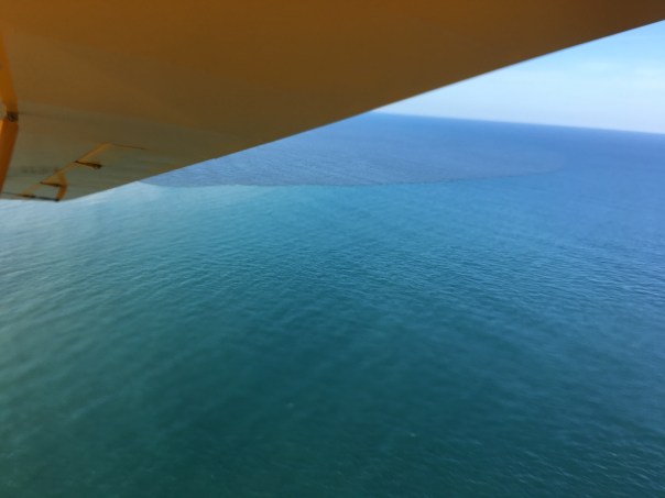


 The ACOE has EAA Storage on their construction schedule for 2021. By 2021 the estuaries will surly be dead.