Tag Archives: change

Tales of the Southern Loop, Marathon to Key West, Part 5

Tales of the Southern Loop, Stuart to Boyton, Part 1

Tales of the Southern Loop, Boyton to Miami, Part 2

Tales of the Southern Loop, Miami to Tavernier, Part 3

Tales of the Southern Loop, Tavernier to Marathon, Part 4    

Tales of the Southern Loop, Marathon to Key West, Part 5

The trip from Marathon to Key West was stunning. The sun was shining, it was the 11th of September, 2020, and the water was turquoise blue. Ed rounded Adrift under the Seven Mile Bridge, once the area of Henry Flagler’s famous Oversees Railroad. 

-Entering the Atlantic- going under the 7 Mile Bridge, Key WestAfter about an hour, I noticed something. I walked up the ladder to the upper helm.

“Babe when you come down can you tell me if it smells down here?” 

“What smells,” Ed asked.

“The cabin.”

“The salon? It smells? Did you flush properly?” he inquired. 

I rolled my eyes, “yes,” I replied, wondering if I did hold the foot pedal down long enough to draw water. 

We had another five hours before we reached Key West; I decided to put “the smell” out of my mind. As we looked out upon liquid glass water, I could see Ed smiling, stress free.

-Ed looks upon the blue Atlantic! The trip was absolutely beautiful. It was quiet and the water was almost like a blue mirror. I knew that the Keys, like all Florida, has water issues, but on a day like today you would never know. Ed and I enjoyed looking back and forth at each other so pleased that we had decided to actually take this trip. Taking three weeks off was something Ed had never done before; we both agreed  to do it NOW as “we’re not getting any younger.”

I climbed around the bow and again walked up the ladder. “On my deathbed I am going to be so glad we took this trip!” I shouted.

Ed smiled,“Always the optimist!” he replied.

I laughed and returned to the kitchen to make lunch.

“I think this is the prettiest kitchen anyone could have,” I said to myself. I looked for dolphins and sea turtles while I made peanut butter and jelly sandwiches. 

-Looking out the window-Approaching Key WestThe time flew by and as we reached Key West I worried about docking as it was getting windy. A&B Marina dockhands, Ty and Kyle, ran out to greet us and thus docking was a non-issue. We did notice right away that we were one of the smallest crafts in the marina; it was filled here mostly with super yachts and large sports fishing vessels.

“I think I’m beginning to suffer from an inferiority complex.” Ed noted looking around.

“I bet they’e not having as much fun as we are!” I quickly replied. 

Ed smiled. 

“Ty please bring us two bags of ice.” I was thinking of happy hour.

“Yes mam.” He said. 

-One of many yachts at A&B MarinaTrue happiness always seems to be short lived, doesn’t it? 

Ed rounded the corner. “What’s that smell?” He inquired.

“I told you, it’s coming out of the bathroom or bedroom. I can’t tell. This trawler should be able to hold more than a few days….” I complained.

“Well, we better pump out.”

“We just pumped out before we left.” I wined.

Ed retrieved a pair of gloves from under the sink and didn’t answer.

When Ty returned with the ice, we told him we wanted to pump out too. Living on the boat really mades one conscious of one’s footprint: water usage, food, plastic bottles, cans, waste, soap… It created an awareness I hoped to bring back to my household. 

Ed and Ty hooked up the giant vacuum. The large yellow tube looked like a fat winding snake. The apparatus slurped and groaned sucking all out of the holding bin. “Gross!” Hard to believe that it wasn’t until the Clean Water Act and the environmental movement of the 1970s that dumping human waste directly into the oceans began to change. Today we are still dealing with the residual problems that accompany our latest way to deal with sewage sludge, Biosolids.

-Ed pumping out sewage
After we pumped out, we decided to take a walk to allow Adrift to air out! Due to Covid-19, the cruise ships had not come into Key West so Ed and felt like we had this historic city all to ourselves. We took a few hours to enjoy the architecture, shared a couple of beers on Duval Street, visited the Ernest Hemingway estate, and laughed at the plethora of chickens, and roosters that greeted us at every corner who thankfully had escaped a tradition of cock-fighting.

-Photos from the Historic District of Key West  Thank God we had pumped out because by the next day, September 12, the storm that had been brewing behind us since Tavernier edged up to Key West. Hurricane Sally was forming just next to us!

“I’m really glad we left Tavernier when we did,” said Ed.

And you guessed it. What was the number one question while we were in lock-down inside the boat?

“What’s that smell?”

Obviously it was more than a pump out issue!

One thing that worried me more than smells, was hurricanes. I was very aware that our trip was taking place at the height of hurricane season, but it was the only time Ed could get away from the office. Thunder rattled the dishes and lightning lit up the sky. The trawler repetitively hit up against the dock. We held our noses finally falling asleep. By morning eleven inches of rain had fallen and much of Key West was flooded. But boy was it good to get out into the fresh air! 

Ed and I decided to not yet work on “the smell,” but we did immediately resume our roles as tourists! 

Hurricane Sally formed just northeast of Key West from a tropical storm, September 11th and 12.

Click her for video of Hurricane Sally forming!

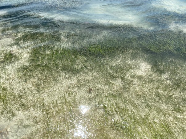
-A very wet rooster the morning after tropical storm’s torrential rains-Ed at the laundry matt and enjoying ourselves as TOURISTS!The Key West Butterfly & Nature Conservancy  -Key West Trolly Tours – sight seeing! -A modern day conversation with Henry Flagler 🙂-View of the Key West Lighthouse from the Hemingway Home  & photos of 2 of 60 cats, most with 6 toes!-Mural on Duval Street-The classic Key West tourist photo: Southern Most Point USA -Resident iguana on ONE HUMAN FAMILY art After sightseeing, Ed and I went to West Marine and bought a filter to hopefully fix the toilet. But to take advantage of good weather, we first we took a spin in the dingy to check out the water. Amazingly enough, it looked terrific. There were queen conch hiding in lush seagrass beds, many water birds diving, and minnows and other fish jumping. The water appeared healthy in spite of the large mooring area, marinas, and heavy boat traffic.

I thought about the all of history I had learned in Key West. As with most places there was an earlier era where people thought there were no limitations of their natural resources, and Key West was one of those places! 
-The large sign below is erected in the heart of the city called the Historic Seaport of Key West. This area was once known as the Key West Bight where green sea turtles, pink shrimp, and sponges were harvested until exhaustion. Basically until no more were left…

This is not a part of Key West history we like to brag about, but perhaps it’s the most important story of all. The story of change, the story of recognizing poor practices and changing one’s ways. 

It might not be a perfect story but like the Atlantic’s blue glass water it reflects a beauty. Human beauty. The beauty to be able to do better,  to change. 

Ed looked at me, “Speaking of change, let’s go change that filter!”  🙂


FIU historic photos Key West, FL, ca. 1907


Key West Aquarium 2020, Educating People About & Protecting Sea Turtles

“See you next for part 6, Key West to Cape Sable” 


How Things Change ~1971 Aerial East Ocean Blvd.

Stuart, St Lucie River, Sewall’s Point, Indian River Lagoon, and Hutchinson Island, Atlantic Ocean, Martin County, Florida 1971

St Luice Blvd (L) East Ocean Blvd.(R)  1971, courtesy, archives historian Sandra Henderson Thurlow.

“I have enjoyed looking at this aerial taken in 1971. Too bad our little house on Edgewood is out of the photo. It shows the location of the future Monterey Road through the Krueger property. The Krueger building to house Merrill Lynch has not been built yet but you can see the little surgery center was already built. I think I can see Mimi and Grampy Tom’s house in Snug Harbor–at least the driveway. So many things yet to be built.” Mom

My mom, local historian, Sandra Thurlow, recently shared this aerial with my brother, sister and me as we grew up here in Martin County. It’s a really great photograph capturing a growing community. Look how Hutchinson Island, Sewall’s Point, and even parts of East Ocean were undeveloped. No Indian River Plantation, later renamed “Marriott Hutchinson Island.” No Cedar Point Plaza. No Benihana! White sands shine through the remaining forest denoting scrub habit, home to threatened and endangered scrub jays and gopher turtles. This sand pine scrub habitat that made up most of Florida’s east coast is now considered one of the most endangered habitats in the world. The East Ocean Mall on the right sits next to a flower farm. At this time flower farms were giving way to roads and development. Already, the freshwater ponds have been directed and drained, and obviously thousands of sand pines have been mowed down for condos, houses, farms, roads, and shopping centers. By 1971 this area was fully on its way to build-out as we see below in 2020.  Nonetheless, from air and ground this area of Martin County stands out as one of the most beautiful.

But it would be fun to bring back some of the scrub habitat ~easy to do by just altering our yards. How things could change…

Close-up Google Earth 2020
Google Earth 2020


Earth Day Must Mean Change…

Earth Day 2020 will certainly go down in the history books. The worldwide outbreak of Covid-19 gives all of us a new lens to view the world, our fragile blue planet… Certainly everyone sees “change” differently. For those of us along the Treasure Coast, when we think of Earth Day we may think of water. Since 2013, thousands of us have come together amplifying a longstanding fight  for clearer, cleaner water. We started a modern movement that caught traction, and indeed, changed the political landscape and perceptions of Floridians. We are making progress! But big change comes slowly, thus we must do all we can ourselves right now. It must start with “little things,” like with how we think about pollution; how we live; how we use, develop, and protect ours lands; how we manage our pesticide-fertilizer-water-hungry lawns, or get rid of them all-together; how we think about food, transportation, and most important, our expectations of large scale agricultural production. It’s overwhelming really. But it’s a must. Earth Day cannot just be a celebration, a recognition, it has to bring real change, right now.  

NASA 2015 Blue Marble

NASA the blue marble series- our fragile planet from outer space

2013, 2016, 2018 JTL/EL: St Lucie River/Indian River Lagoon and Lake Okeechobee during multiple toxic algae crises, not long ago, a strong reminder of the need for continued change. We cannot ever again allow such polluted waters upon our Earth. 

Photo: Dr Scott Kuhns, 2018

Photo: Mary Ratabaugh, Central Marine 2018

Bathtub Beach Historic Photos; “The Only Constant is Change.” SLR/IRL

Bathtub Beach has become a preoccupation this week, and its story “teaches us.” I asked my historian mother if she had any historic photos. Of course, she did, along with insights of this special place in Martin County.

The first thing she said was, “I have been fascinated with the giant black mangroves that used to appear when the Bathtub’s sands eroded. I have a bunch of these photos…”

In my childhood days, this sometimes appearing ancient forest was a conundrum, then a lesson, that things are ever-changing, and barrier islands really are moving. “How could there have been a forest there?” I’d ask my mother, “It’s in the sea?”

This part of Hutchinson Island was developed early on as “Seminole Shores” and there is one photo below that clearly shows the water washing out over the road way back then in the 50s (sepia colored aerial.) Interesting.

From the aerials, one can see how developer, James Rand added the marina we know today as part of Sailfish Point. This type of construction was later outlawed in the 70s due to its serious environmental ramifications. Many of our older area marinas were built this way.

Some may remember famous “Rand’s Pier” that withstood the ocean’s occasional violence for many years. It was still there in the photos towards the end of this blog post that I took in 2007. It has since washed away…

The circular, unusual, worm-reef, giving Bathtub Beach its name, is most beautiful. Although people are not supposed to walk on it, they do; and today’s constant/desperate re-nourishment sands washing back into the ocean must certainly have a negative effect.

As a kid I swam over the reef at high tide catching tropical fish with a net my mother made by hand. Once a moray eel put its face on my mask and I learned not to put my hand in a hole!

Look at photos closely and you will notice many details.

In the first photo, you will see there is no Wentworth house falling into the ocean, and then it appears; the ancient forest foreshadowing its fate.

The final aerial is recently dated and from a tourist website, shared by my life-time friend Amy Galante. This photo packages Bathtub Beach as we all envision it. Airbrushed. Restored. Never changing. And “perfect.”

Fortunately, or unfortunately, perfection takes constant change.

November 22, 1992, before the Wentworth house was built. Erosion reveals ancient black mangrove forest. Photo, Sandra Thurlow.

December 6. 2003, after the Wentworth house was built, also showing ancient black mangrove forest. Photo, Sandra Thurlow.

“This one is good because it shows the reef.” Photo, 1994, Sandra Thurlow.

“The date of the Seminole Shores photo that shows the pool, etc. was, July 6, 1959. They started dredging the marina in October 1957. The washout below would have been a little before then when they were improving the road to Seminole Shores.” Photo, archives of Sandra Thurlow.

“This photo shows the position of pier in Seminole Shores and a close up of added  marina in IRL ca. 1950s. Today’s Bathtub Beach is just north of the pier.” Photo archives of Sandra Thurlow.

“As mentioned, the washout would  have occurred when they were improving the road to Seminole Shores. (Look to southern portion of scraped and treeless area for washout over road.) Although this photo is the most detailed I have of the area,  unfortunately there is not an exact date on this Ruhnke aerial. It is before they began to develop Seminole Shores. Perhaps that log looking thing in the water is the first part of the dredge?” Photo, archives of Sandra Thurlow

1957, construction of Rand’s Pier. Again, Bathtub Beach is just north of this area. Photo, archives of Sandra Thurlow.

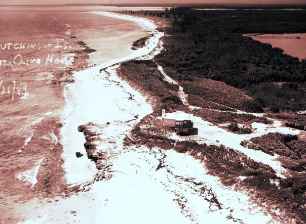
Dated, 6-26-49, this Ruhnke aerial reveals much from an earlier era: the St Lucie Inlet, the shoreline of south Hutchinson Island, the Clive House built behind the dune and Anastasia Rock formation, road cut through heavy vegetation, and reflecting coquina sands.  Drowned trees in the distance are visible in the crescent of the shoreline showing the remains of the black mangroves. Notice the dark peat underneath them along the shoreline. At low tide the worm rock reef is revealed creating what came to be know as Bathtub Beach. Photo, Ruhnke Collection, Thurlow archives.

The photos below were taken by me in 2007.

Bathtub Beach 2007, JTL Remains of black mangroves  in ocean looking towards worm reef is revealed by Mother Nature once again…

Bathtub Beach 2007, JTL

Bathtub Beach 2007, with tree trunks. JTL

Bathtub Beach 2007, JTL

Bathtub Beach’s famous worm reef, 2007, JTL

Bathtub Beach,  worm reef growing on ancient black mangrove trunk. This area fills with sand and then naturally erodes based on tides and storms.  2007, JTL

Bathtub Beach 2007, remains of Rand’s Pier. JTL

Beach re-nourishment, Bathtub Beach 2007, JTL

Erosion, roots hold in sand. Bathtub Beach 2007, JTL

Bathtub Beach 2007. Structures and walkways have been replaced many times due to erosion over the years. JTL

Worm reef grows on ancient black mangrove trees. Bathtub Beach 2007, JTL

Bathtub Beach aerial —

Airbrushed and in “all her glory.” 2016 advertisement for Martin County’s Bathtub Beach: http://florida-wilderness.com/wp-content/uploads/2016/02/bathtubbeach.png

Earlier blog post “Bathtub Beach Bye-Bye” https://jacquithurlowlippisch.com/2017/11/14/bathtub-beachbye-bye/

History Seminole Shores:

Documenting the Discharges 11-8-17, SLR/IRL

A lone sailboat is a sea of blackness, confluence of the St Lucie River/Indian River Lagoon, once considered the most biodiverse estuary in North America and full of seagrasses, a nursery for the ocean..
http://w3.saj.usace.army.mil/h2o/plots/s308h.pdf
I am very fortunate to have a small army of people helping me document the  Lake Okeechobee discharges this year. Presently, it  is the tremendous rate of government sponsored discharge from Lake O that is destroying the regions’ economy and ecology, right before our eyes, ~once again.

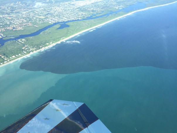
Friends of my husband, pilots Dave Stone and Scott Kuhns, took these aerials yesterday, 11-8-17 around 5 pm. When I asked Scott about the plume, he relayed that it went 15 miles south almost all the way to Jupiter Inlet, and since there is also rain driven, fresh, dark- stained water flowing out of the Jupiter Inlet (not over-nutrified, black-sediment water from Lake O) there was no clear delineation of blackened plume to aqua ocean water, like usual–rather, the waters are all dark….

“How far did the plume go east from the St Lucie Inlet?” I asked. “From the coast, as far as the eye could see…”

End of plume, near Jupiter Inlet
Another angle end of plume near Jupiter Inlet
Up close of a boat in the plume. Look at the sediment! Covering what once was seagrasses and killing our near shore “protected” reefs.
Plume in black water. Brown on black. The ocean? You’d think it was an oil spill.
Plume as seen at mouth of St Lucie Inlet near multi million dollar homes in Sailfish Point.
Plume at mouth of St Lucie Inlet on south side as seen against Jupiter Island’s state park/Jupiter Narrows.
A lone sailboat is a sea of blackness, St Lucie River/Indian River Lagoon, once considered the most biodiverse estuary in North America and full of seagrasses, a nursery for the ocean.
Plume exiting St Lucie Inlet
The north Jetty at the St Lucie Inlet with plume waters going into the Atlantic Ocean. The plume goes east for many miles.

http://w3.saj.usace.army.mil/h2o/reports.htm–cfs over 4000 has been going on for weeks. A total blowout.
 

Lake O is connected to the St Lucie through the C-44 canal.
*Lake O level:http://w3.saj.usace.army.mil/h2o/currentLL.shtml

*The ACOE has been discharging from Lake O since Hurricane IRMA hit on Sept 2oth, 2017. The rate of discharge has gone up and down, however increasing over recent weeks. Word is the St Lucie could be dumped on for many more months, possibly through the end of the year. So don’t count on taking your visiting relatives out fishing this holiday season even though you moved here for the water. This ecological disaster is finally seeing light at the end of the tunnel as Senator Joe Negron, alongside the public, and “River Warrior” groups, particularly Bullsugar, has pushed so hard  that the SFWMD and ACOE are finally working  towards building an EAA Reservoir that will begin the long journey of changing water drainage culture in South Florida, and “sending the water south.” Please get involved and learn more by viewing this SFWMD EAA RESERVOIR website:https://www.sfwmd.gov/our-work/cerp-project-planning/eaa-reservoir

*Thank you to the people, and the children, groups such as the C4CW, Rivers Coalition, grandparents’ HOA email chains, leadership at Martin Health System, and to the those working for the agencies trying to help the St Lucie. As the River Kidz say: 

The Long Forgotten Wetlands of East Ocean Boulevard, SLR/IRL


4th Street/East Ocean Blvd 1957, Stuart, Florida, Arthur Ruhnke. Courtesy archives of historian, Sandra Henderson Thurlow.  
“See that white strip just below the wetland? That is the extension of Flamingo Drive that skirts the pond behind the old car wash. They just dug a retention pond and conducted the water to it. All of that pineland is covered with condominiums today.” (Cedar Point, Vista Pines, and Kingswood)~ Sandra H. Thurlow


__________________________________________________

Today we drive over the Indian River Lagoon and St Lucie River surrounded by “civilization,” and forget that once it was once a wetland and pine forest full of wildlife. In the course of a lifetime, these things are long forgotten.

The above 1957 photograph hangs in my brother’s law office. When I visit him, I find myself staring at it for long periods of time. It is one of those rare photos that really puts things into  perspective. The road construction through the wetlands, (note it going through the pond, and pine forest) was all taking place around the same time that the “Bridges to the Sea,” from Stuart to Sewall’s Point, and Sewall’s Point to Hutchinson Island, were completed. It’s amazing to see what the landscape once looked like. The road in the photograph, Fourth Street, was renamed “East Ocean Boulevard” in 1960, and is a major thoroughfare to the  beaches today.

Jenny, Todd and I 1973, alligator in background.
I remember early East Ocean Blvd, although it was already quite changed by the time I was born in 1964. My family lived at 109 Edgewood Drive in Stuart, a short distance away from these wetland ponds under development. I recall Scrub Jays in our back yard and feeding them peanuts. By 1974 the family moved across the river to Sewall’s Point “growing and improving” with the changing landscape.

By 1979, when I was fifteen  years old, riding my bike over the bridge to Stuart to work at the Pelican Car Wash, the beautiful wetland pond had been relegated to a retention pond for run off.  Over the next two decades, you didn’t see wetlands and ponds anymore, or wildlife, just condominiums, office buildings, and shopping plazas. The state four-laned East Ocean Boulevard and built higher bridges to the ocean too.

Believe it or not, the pond in the aerial is still located behind a gas station that used to be the car wash. It is not even a shadow of its former self. Two days ago, I drove by and noticed that there was an extensive algae bloom in the pond backed up to the  parking lot and gas pumps; the water reflecting a sickly shade of green.

I sat there thinking about the long forgotten pond in the middle of East Ocean Boulevard in the photo I love in my brother’s office, wishing the developers had figured out a way to go around the pond. As the shortest distance between two points, over time, is not always a straight line.

East Ocean Blvd 1957, courtesy historian, Sandra Henderson Thurlow
 

Flamingo and retention pond at Flamingo and East Ocean 2017, once a wetland.
Google map of East Ocean Blvd. through what was once wetland and forest, 2017.
1940s Dept of Agriculture photographs of Martin County showing wetlands. Courtney Todd Thurlow and UF archives.
Overlay 1940 aerials over Google map today, Todd Thurlow.
USDA History of Wetland Development in Florida: https://www.nrcs.usda.gov/wps/portal/nrcs/detailfull/fl/newsroom/features/?cid=stelprdb1252222

Bridges to the Sea, Luckhardt Vignette TCPalm Series: http://archive.tcpalm.com/news/historical-vignettes–martin-county-bridges-and-bridge-tenders-ep-306449407-342336761.html

The Dramatic Shifting Sands of Ft Lauderdale, SLR/IRL

FullSizeRender 4
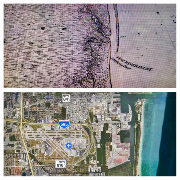
Comparison of 1883 historic map and Google Earth image 2017, Ft Lauderdale’s New River Inlet

Today I am sharing two creations of my brother, Todd Thurlow. Entitled “Ft Lauderdale House of Refuge/Life Saving Station,” and “Short Version,”they were originally for my mother, Sandra Henderson Thurlow and Timothy Dring’s “Image of America, U.S. Life Savings Service” book presentation at the Elliott Museum.

For me, Todd’s videos are mind-boggling as they bear witness to how much and how fast we humans can change the  environment. Like an army of ants, we organize; we build; we destroy; we create…

By comparing and contrasting Google Earth maps of today with historic maps from 1883, 1887, and 1935, Todd’s “time capsule flight,” takes us through time and space to see the shifting sands of the multiple New River Inlets; Lake Mabel that morphed into Port Everglades; remnants of the forgotten Middle River that spread and contracted into new canals and developments; and of course, for mom, House of Refuge #4, that once rested north of a New River Inlet that today we can see is completely filled in, while beach-goers relax in reclining chairs like nothing ever happened!

Maybe one day we humans can use all this energy and ability to really fix our waters that have been destroyed during all this construction? Wouldn’t that be a dramatic video?

In closing, in the early 1900s, the New River… that was believed by the Seminoles to once be an underground river that collapsed and the Great Spirit revealed during an earthquake… was selected by modern-day humans as the “natural channel” to connect two of the largest drainage canals from Lake Okeechobee to the Atlantic Coast, the North New River/South New River, and the Miami.

Please watch and enjoy Todd’s videos below!

Long Version with old New River Inlet:

(Link to video: https://www.youtube.com/watch?v=Ge1bCV5Tz5Q)

Short Version:

(Link to video: https://www.youtube.com/watch?v=oYWga93XL3w)

f10595-gif

1936 historic write-up, Francis H. Miner,  Federal Writer’s Project Ft Lauderdale, https://www.broward.org/library/bienes/lii10210.htm

Click for enlarged images:

To contact Todd: http://www.thurlowpa.com and you can access all of Todd’s videos here: http://maps.thethurlows.com.

Kait Parker’s “Toxic Lake, The Untold Story of Lake Okeechobee,” SLR/IRL

IMG_7748.jpg
Kait Parker’s website: https://kaitparker.com

Vimeo video link: (https://vimeo.com/194372466)
Website Toxic Lake video and article : (http://www.toxiclake.com)

On May 10th, 2016 there was a knock on my front door. I was expecting somebody. Kait Parker and her team from the Weather Channel had arrived via New York to do a story on the St Lucie River/Indian River Lagoon.

The group was upbeat and friendly. They interviewed Ed and me in our kitchen, and later we took them up in both the Cub and the Baron to shoot footage and to get “the view.” –The aerial view of the discharges from Lake Okeechobee that had started this year on January 29th.

What really struck me about Kait was that although this Texas girl’s beauty, talent, and ambition had moved her beyond the Treasure Coast to Atlanta’s Weather Channel, (Kait had been a well-known and loved meteorologist for three years at WPTV, the West Palm Beach/Treasure Coast NBC affiliate), she had come “home” to see what the heck was going on. She, as so many others, had heard the horrible stories of destruction facing the St Lucie River/Indian River Lagoon.

I commend Kait for coming back to see for herself and for using her fame to share our story with others. This gesture will not be forgotten and “Toxic Lake” is already making waves! Waves of change.

Thank you Kait.

13177920_866670106794672_9077317480558941624_n.jpg
With Kait Parker

13220968_866670130128003_49667077217337170_n.jpg
Getting camera and barf bag ready just in case

13177421_866670136794669_2482155466641419185_n 2.jpg
Ed explaining something.

13102866_866670116794671_5036972925007835261_n.jpg
Smile

13221478_866670173461332_4235258640774153875_n.jpg

IMG_1749.JPG
Discharges from Lake O through the St Lucie Inlet 5-10-16

IMG_1756.JPG
Plume rounding Jupiter Island through St Lucie Inlet 5-10-16

IMG_1758.JPG
St Luice Inlet 5-10-16

IMG_1763.JPG
Crossroads and SL Inlet 5-10-16

*Thank you Kait Parker,Spenser Wilking,and Andy Bowley.

1884 Rand, McNally & Co. Map, the Everglades and Lake Okeechobee,”My How Things Change…”SLR/IRL

001
Rand, McNally, and Co. 1884 (Bloomfields Illustrated Historic Guide) Library of Sandra Henderson  Thurlow.

Yesterday, my mother, historian Sandra Henderson Thurlow, came across this map while going through some old things…isn’t it a beauty? Look at the sprawling Everglades! Look at how the St Lucie River was not connected to Lake Okeechobee– at all…Look how at that time the inlet, Gilbert’s Bar, our inlet, was open…naturally.

When my mother came across this image, she wrote my brother and I:

“I know Todd has every map there is but still holding an original is fun and I thought the configuration of Lake Okeechobee was interesting on the 1884 Rand, McNally & Co. map tucked in the back of Bloomfield’s Illustrated Historical Guide. Of course it was too big for me to scan the whole thing. I love it that I know right where I am on this map. I am about on the former Dade/Brevard County line as I type this.” Mom

What is she talking about? Our family home in Indialucie, Sewall’s Point, named so as it is located between the St Lucie River and Indian River Lagoon, sits on the border of what once was Dade and Brevard counties. Since I was a kid there has been a piece of wood nailed to a tree, in my parent’s back yard that reads: “Dade County.”

My, how things change..too bad we didn’t save more our state’s natural water connections. Swamp or no swamp, it must have been beautiful. But I am glad our family home in now in Martin and not Dade County. 🙂

Jacqui


FullSizeRender
Map of Florida’s changing counties. (SHT)


Rand,McNally’s history: (http://designorati.com/articles/t1/cartography/385/a-brief-history-of-rand-mcnally.php)

Rand’s Pier Remembered, Seminole Shores-Sailfish Point, SLR/IRL

Rand's Pier 1957. Photo via Sandra Henderson Thurlow and Thurlow Archies.
Rand’s Pier being built in 1957; the pier  was built out 400 feet into the Atlantic. I visited the pier often through the 60s-80s growing up in Martin County. Photo Sandra Henderson Thurlow archives.

Aerial of Seminole Shores. Thurlow Archives.
Aerial of Seminole Shores. Thurlow Archives, ca. 1950s.

I think it is typical to think the time one grew up in was the “best of times,” but I feel mine really was…

One of my fondest memories of growing up in Stuart is visiting Rand’s Pier at Seminole Shores on Hutchinson Island. This area became today’s Sailfish Point. Tromping through the hot sands, my mother would lead my brother, sister, and I down a long, winding, sand-spur/beach-sunflower covered path. Finally, we would arrive at our destination, a pier that would provide shade and shelter for the outing.

From here my brother, sister, and I would take our buckets and nets and catch baby fish, collect shells and sea glass, or dig holes and bury each other up to our necks.

1957 Seminole Shores. (Photo Thurlow Archives)
1949 Seminole Shores. (Photo Thurlow Archives/Ruhnke)

The pier was a reference point for a time past, and man gone, who my mother said was famous. The man was James Rand Jr. of Rand Ledger Corporation decent who went on to build his own fortune. An impressive eccentric,  a Harvard graduate, with his share of troubles—but always a gifted business man— he did many wonderful things for Martin County including becoming a benefactor to the hospital and helping found and fund the Florida Oceanographic Society. Although it was not to be his fate, he had dreams of fully developing what was then known as Seminole Shores—-today’s Sailfish Point.

According to the History of Martin County: “In the early fifties James Rand acquired part of what was known as Seminole Shores on Sailfish Point three miles south of the House of Refuge. It was his intension to develop the area with exclusive residences, a marina, a clubhouse, cabanas, and a restaurant. He built the marina, the clubhouse and yacht basin, laid out and paved a number of streets, and built some thirty cabanas  in a semicircle around a swimming pool, facing the ocean that one might take advantage of either fresh or salt water bathing.  He also put in the telephone lines for the south end of the island at a cost of approximately $15,000…”

When my siblings and I were running around we did not think much about the man who built the pier, or put in the telephone lines, or helped make the island accessible for us to play. But his name always stuck in my head as someone who had made a difference to Martin County. The years have passed and Martin County has changed.

Today, Sailfish Point is beautifully developed– certainly beyond what Mr Rand would have ever imagined. The pier? Time tide and time have taken it: it has washed away– But when I walk the beach I still look for it and remember the “best of times”…

Pier 2009. (Photo JTL)
Remaining pier 2009. (Photo JTL)

My husband Ed under the pier in 2009. The pier washed away a few years later after a great storm.
My husband Ed under the pier in 2009. The entire pier washed away a few years later after a great storm. (JTL)

Beach sunflowers
Beach sunflowers…(JTL)

James Henry Rand Jr. 1886-1968: (http://www.wikitree.com/wiki/Rand-1):
Historic Vignette including story of James Rand and his good works, historian, Alice Luckhardt: http://www.tcpalm.com/news/historical-vignettes-interesting-stories-and-facts-about-martin-county-part-2-ep-349553375-340215561.html

Hutchinson Island’s Indian River Plantation, the Shifting Sands of Time, SLR/IRL

Hutchinson Island 1957
The barrier island of Hutchinson Island, 1957. Atlantic Ocean on left. Indian River Lagoon on right. Photo courtesy of Thurlow Archives.

The sands of time….shifting, reforming,  just like my childhood memories. 1977–Seventh grade—I remember riding my bike with my best friend, Vicki, out to Hutchinson Island. No  traffic. Along the way we would take our hands off the handle bars holding them over our heads, laughing and shouting “look mom!”

A veritable paradise and giant playground we left our bikes at Stuart Beach not locking them and jumped into the ocean.

This photo was taken in 1957, twenty years before Vicki and my bike ride, but it was still relatively undeveloped at that time. If my memory serves me correctly Indian River Plantation’s first condo, The Pelican, went up in 1976 and later in the 1980s the establishment filled out to its final glory. Later sold to the Marriott these lands, though altered, remain a beautiful part of Martin County with public beaches for all to enjoy.

I got ahold of this photo from my mother asking her what kind of vegetation pre-development was on the island. This was her reply:

“This aerial was taken on October 16, 1957. The causeway was under construction as were improvements to Stuart Beach. It is hard to tell what kind of trees are there. They were probably a variety of things, oak, salt bush, cabbage palms, palmetto and Australian pine. The later were growing at the House of Refuge at this time so they were no doubt popping up everywhere. It was “disturbed land” since patches of it had been cleared for farming. Mangrove would be growing along the water but I doubt they had reached inland yet. You can see the new piles of sand indicating mosquito ditches had recently been dug. Notice the little Beach Road.” Historian,  Sandra Henderson Thurlow

Thinking a bit more about this area I asked my brother, Todd Thurlow, if this area formed “the fan” because it was once an inlet, such as the Gap, he talks about so much. He sent me this:

“The steady forces of long shore drift have operated over the eons to produce not just the current BI and previous BIs such as the ACR on the mainland, but even the peninsula of Florida itself (Schmidt 1997). The strong linearity of the east central and southeast Florida coastline, its low fractal dimensionality (Rial n.d.), indicates the steadiness and consistent directionality of these forces. Chaotic events like storms, on the other hand, produce drastic BI and lagoonal modifications via overwash and tidal inlet cuts, and leave chaotic, or irregular (“squiggly”) backbarrier shorelines, the former producing overwash fans, and the latter producing flood tidal deltas (Figure 3-6).

Figure 4-19. Cartographic signatures of geomorphic stability and instability. Map to left is most north, right map is most south”

Alan Brech, NEITHER OCEAN NOR CONTINENT: CORRELATING THE ARCHAEOLOGY AND GEOMORPHOLOGY OF THE BARRIER ISLANDS OF EAST CENTRAL FLORIDA, 2004.
——————————

Translation: Breaks occurring during storms create overwash fans. (e.g. IRP and Sailfish Point). Tidal inlets produce flood tidal deltas, somewhat like the old Gilberts Bar. BI = Barrier Island; ACR = Atlantic Coastal Ridge. —-Todd Thurlow, “Time Capsule Flights:”(https://www.youtube.com/playlist?list=PLDaNwdmfhj15bmGNQaGhog9QpkQPAXl06)
The shifting sands of time… So many wonderful memories, and so many more to make as times and sands continue to change.

IRP Marriott today, Google Maps.
IRP Marriott today, Google Maps 2015.

Wide view, red dot is IRP Marriott.
Wide view, red dot is IRP Marriott 2015. Sewall’s Point east.

____________________________________
The IRP Marriott today/photos:(http://www.marriott.com/hotels/travel/pbiir-hutchinson-island-marriott-beach-resort-and-marina/)

Mullet Jump! St Lucie River/Indian River Lagoon

A mullet jumps in the St Lucie River off North River Shores. (Photo Todd Thurlow, 10-10-15.)

Mullet are famous for being excellent jumpers. In fact, Florida Fish and Wildlife states “it’s often easy to identify their locations by simply watching for jumping fish.” Me? When I see a mullet jump, I have a tendency to personify thinking, “now there’s a happy fish!”

This beautiful jumping mullet-sunset photo was taken by my brother, Todd Thurlow, this past Saturday evening, October 10th, 2015  just off of North River Shores.

Former Stuart News editor and river advocate Ernest Lyons wrote about mullet jumping in his essay ” Never a River Like the St Lucie Back Then.”

There was never a river to compare to Florida’s St Lucie I when I was young….the river fed us. You could get all the big fat mullet you wanted with a castnet or a spear. If you were real lazy, you could leave a lantern burning in a tethered rowboat overnight and a half-dozen mullet would jump in, ready to be picked off the boat bottom next morning….at the headwaters of the south fork of the St Lucie….the waters were clear as crystal… (Ernest Lyons 1915-1990)

Today, the water of St Lucie River/Indian River Lagoon are anything but clear, but “hail to the mullet that are still jumping!”

Sunset over the St Lucie, Todd Thurlow, 10-10-15.

......
……

....
….

Mullet: Florida Fish and Wildlife: (http://myfwc.com/fishing/saltwater/recreational/mullet/)

Ernest Lyons, Stuart News editor, writer and award winning conservationist: (http://www.flpress.com/node/63)

Todd Thurlow: (http://www.thurlowpa.com)

SFWMD’s St Lucie River history (http://www.sfwmd.gov/portal/page/portal/xweb%20protecting%20and%20restoring/stlucie)

Florida Sportsman, by Larry Larsen, Fishing Mullet Schools: (http://www.floridasportsman.com/2013/09/24/mullet-schools/)

Why Mullet Jump, by Terrie Gibson/Visit Florida: (http://www.visitflorida.com/en-us/fishing/articles/2013/february/8431-why-mullet-jump.html)

Stop by the Stuart Heritage Museum to purchase Ernest Lyons’ books with writings about the St Lucie River:(http://www.stuartheritagemuseum.com)

Sailfish Point’s Seawall “in the Sea”… St Lucie River/Indian River Lagoon

The seawall at Sailfish Point  right next to the ocean. 7-26-15. (Photo Ed Lippisch)
The seawall at Sailfish Point’s Dunes Condominium is right next to the ocean. St Lucie Inlet lies beyond this point by about a quarter-mile. 7-26-15. (Photo Ed Lippisch)

Yesterday afternoon, Ed and I had hoped to walk our dogs, Bo and Baron, to the St Lucie Inlet, but were cut off by an incoming tide and a Sailfish Point’s seawall. Having grown up  in Martin County, it is amazing to see such changes “right before my 50-year-old eyes…”

Of course when I was a kid there was no Sailfish Point development, no seawall, no apparent sea level rise, just the beach sun-flowered sand dunes and Bathtub Beach changing daily to the winds of time with the remnants of James Rand’s “Seminole Shores” development crumbling…

Today Sailfish Point is here. Its 625 homes are some of the most exclusive in the county. Built in the 1980’s it was developed by Mobile Oil Corporation. The area brings tremendous tax revenue to everyone and to every school in Martin County…if it washed into the sea there would be issues for all.
Sailfish Point: (http://www.sailfishpoint.com/martin-county/)

It must be noted that the St Lucie Inlet itself is responsible for some of this erosion…the inlet was opened permanently in 1892 by pioneers led by Captain Henry Sewall of Sewall’s Point. Naturally the inlet would open and close with tides and time. Opening the inlet permanently now defines our county, and we would not give it up;  but as all things in life: there are both positives and negatives to every action.

Today the waters of the ocean are encroaching….and time seems to be speeding up.

Building on barrier islands is not particularly long-term in that barrier islands are meant by nature to turn over on themselves like a conveyor belt. On the other hand, I have been to the Breakers Hotel in Palm Beach and their seawall is right up to the historic hotel and has been for years….We stave off the ocean as long as we can. Much of Florida east coast is built on barrier islands…

What does the Bible say? “The wise man built his house upon a rock…”

Anyway….today I wanted to share Ed and my walk as it is symbolic of our times.

Google map showing Hutchinson Island with Sailfish Point south next to St Lucie Inlet. East is Atlantic Ocean and west is the Indian River Lagoon and Sewall's Point.
Google map showing Hutchinson Island showing St Lucie Inlet. Sailfish Point immediately north of inlet. East is Atlantic Ocean and west is the Indian River Lagoon and Sewall’s Point and St Lucie River.

Other than the surreal seawall and encroaching sea….there were many sea turtle nests, marked by the Fish and Wildlife Commission. Many turtles had laid their eggs right up against the seawall! Many of them! I counted at least 50 just in our short walk. Good for the turtles but it seems many nest are doomed to wash away… For thousands of years these turtles have returned to the beaches of their birth to lay eggs. Now many of them literally come up “against a wall.”

Turtle nest right up the seawall at Sailfish Point. 7-26-15.(Photo JTL)

Turtle nest close to SP's seawall. (JTL)
Turtle nest close to SP’s seawall. (JTL)

Sea turtle nest. (JTL)

I must mention that the people of Sailfish Point are also “up against a wall,” as they have to worry about their homes falling into the sea….Here one sees a sea wall repair taking place. I don’t think the sea wall is that old in the first place.

Home at Sailfish Point undergoing seawall repair. 7-16-15. (Photo JTL)
Home at Sailfish Point undergoing seawall repair. 7-26-15. (Photo JTL)

Ed looks inside sea wall being repaired. (Photo JTL)

The most intense erosion seems to be the north area of Sailfish Point, closest to Bathtub Beach….and it is summer. This should be the time the ocean, sands and tides are most forgiving. Winter waves are much more brutal, unless there is a hurricane of course….

The other interesting anomaly Ed, Bo, and Baron and I experienced was the hundreds of sea hare mollusks that had washed up on shore. Ed Killer of TC Palm just wrote a great piece on these interesting, harmless creatures that scientists believe are washing ashore due to cold water upswells and algae shifts in the ocean–their swimming affected, they slow down and are carried to shore by the waves fated to dry out in the sun.

As Ed and I walked back I picked up as many as I could and threw them back into the ocean knowing that really I was only “buying them some time.” Chances are they will wash right back up on the shore. In the end, nature always wins. In time, we like the sea hares, will find this out , but until then it’s a great walk on the beach, isn’t it?

A sea rabbit that had washed ashore near Sailfish Point 7-26-15. (Photo Ed Lippisch)
One of hundreds of sea hare mollusks  that had washed ashore near Sailfish Point 7-26-15. (Photo Ed Lippisch)

Video of sea hare: (https://youtu.be/_Oa_xeM67p0)

Ed stands with Bo and Baron in front of the seawall at Sailfish Point looking towards the sea....(Photo JTL)
Ed stands with Bo and Baron in front of the seawall at Sailfish Point looking towards the sea….(Photo JTL)


Playing  fetch with Bo and Baron, (Photo JTL)
Playing fetch with Bo and Baron, (Photo JTL)

Jacqui and Ed, Bathtub Beach, Stuart, Florida. 2015.
Jacqui and Ed, near Bathtub Beach, Stuart, Florida. 2015. We had fun even though the beach is not what it used to be….

THIS ADDITION CAME IN FROM MY BROTHER TODD: AMAZING!

Jacqui–

Interesting blog post!

In the meantime I thought I would respond to your post with a rough video of Sailfish Point while eating my lunch…..


Here it is: https://www.youtube.com/watch?v=TW8URTQG2o0&feature=youtu.be

(https://youtu.be/TW8URTQG2o0)
It is a movie of the following:
1. 1935 NOAA Chart – note the jetty already in place
2. 1940 Aerial
3. 1952 Aerial
4. 1968 Aerial – quick. I should have skipped it.
5. 1970 Aerial – note the old “Empire of the Ants” pier and the strange water slick to the south.
6. 1981 Aerial – showing the construction of Sailfish Point.

Look at these two screenshots of the beach just a few months apart late last year—-Todd Thurlow

Google image seawall is covered 8-12-14.

Google image seawall is uncovered
Google image seawall is uncovered 12-2-14.

Sea Hares:(https://en.wikipedia.org/wiki/Aplysiomorpha)

Barrier Islands:(https://en.wikipedia.org/wiki/Barrier_island)

Human Causes of Coastal Erosion:(http://www.coastalwiki.org/wiki/Human_causes_of_coastal_erosion)

History of St Lucie Inlet jetty:(http://www.oceanscience.net/inletsonline/usa/doc/St._Lucie.htm)

Dredge/Fill, “Changing History,” Frances Langford’s Outrigger Resort, Indian River Lagoon

Aerial of Francis Langford's Outrigger Resort's marina, ca. 1955. Visible is the dredge and fill it took to accomplish this project. (Photo courtesy of Thurlow archives.)
Aerial of Frances Langford’s Outrigger Resort’s marina, restaurant, and compound, built in Jensen/Sewall’s Point ca. 1955. Visible is the dredge and fill it took to accomplish this project. (Photo courtesy of Thurlow archives.)


"Mt Pisgah," the area contiguous with north Sewall's Point that was her home. (Photo ca. 1950s, courtesy of Thurlow Archives.)  Note cleared lands and orange groves.)
“Mt Pisgah,” the area of Rio, contiguous with north Sewall’s Point, that was Mrs Langford’s home. (Photo ca. 1950s, courtesy of Thurlow Archives.)

At last week’s Everglades Coalition Conference, (http://evergladescoalition.org), one of my favorite quotes was repeated by respected Martin County resident, and nationally renowned environmentalist, Mr Nathaniel Reed:

“Not knowing your history, is like walking into the middle of the movie.”

For us to be effective advocates for the now impaired St Lucie River/Indian River Lagoon, (http://www.dep.state.fl.us/southeast/ecosum/ecosums/SLE_Impairment_Narrative_ver_3.7.pdf), it is important to know our history, especially the history of ourselves.

Prior to the 1970s, the passage of the Clean Water Act, and the national environmental movement, “dredge and fill”was commonplace. Dredge and fill includes the dredging of canals that have created our Atlantic Inter-coastal Waterway; the dreaded Okeechobee Waterway; canals draining South Florida below and around Lake Okeechobee; the Everglades Agricultural Area; as well as  many prominent subdivisions and commercial centers that we relish today.

Postcard photo of Francis Langford's Outrigger Resort ca. 1960s)
Postcard photo of Frances Langford’s Outrigger Resort ca. 1960s)

After people realized the environmental degradation that unfortunately went along with these projects, (some include: turbidity in the water column, destruction of seagrass and wildlife habitat, and sometimes the release of heavy metals and other pollutants harbored in the bottom sands and sediments,) getting permits to “do such” became much harder.

Today the FDEP, Florida Department of Environmental Protection,(http://www.dep.state.fl.us/water/wetlands/erp/dffact.htm), and the EPA, Environmental Protection Agency, together with the Army Corp of Engineers, (http://water.epa.gov/lawsregs/guidance/cwa/dredgdis/primarily oversee such projects; many are not granted or take so long people give up. 

Another aerial of the completed  marina in 1965. (Photo courtesy of Thurlow Archives.)
Another aerial of the completed marina in 1965. (Photo courtesy of Thurlow Archives.) Note healthy looking seagrasses right off shore.

Mrs. Frances Langford  (http://en.m.wikipedia.org/wiki/Frances_Langford), who built the well-known “Outrigger Resort and Marina, “in the 1950s, just north of Sewall’s Point, became an “environmentalist” in her later days, bestowing tremendous monies toward the Florida Oceanographic Society on Hutchinson Island, (http://www.floridaocean.org).

And yes, she gave to just about every charity in town! The point is, she loved helping “create” Florida Oceanographic in her later years, and in the 1940s and 50s people really did not realize the true extent of the destruction their dredge and fill projects were causing to the world that they loved. I believe this even holds true with some of the worst offenders of the agriculture and development industry who have, in essence, destroyed Florida and its waters. 

But times change, and people change. I believe there is a movement of change right now to “send water south” again…to fix our state, and yet to allow businesses that came into being, during earlier times of our history, to survive and adapt.

Frances Langford 1940s. (Public photo.)

Singing to the troops with Bob Hope. "The favorite time of her life..." (Public photo.)
Singing to the troops with Bob Hope. “The favorite time of her life…” (Public photo.)

As I mentioned, to be able to change the St Lucie River/Indian River Lagoon, we first must learn to look around, to be aware, and to be able to recognize the history of our own area as we try to change the bigger state picture as well.

Once you start looking, you will see that “dredge and fill” is all around us.

You may ask yourself:

“How is a huge boat, going through the IRL that on average is three feet deep?”

“How are those boats coming from Ft Meyers across Lake Okeechobee into the St Lucie River/Indian River Lagoon?”

“Am I living on what used to be a spoil island or the edge of a coastal community of fish and birds?”

“Am I living in a former wetland?”

I know, that although I do not live on the river, “I am;” I live in a coastal hammock in Sewall’s Point, a bird sanctuary.

There is no turning back, but we can change how we create a new history in the future.

By knowing history, there is a way to “rebuild”and “reeducate.” Whether it is starting in your yard, or changing state policy…

So look around you. Learn your history, view the “full movie”…And may the great waters of Florida flow again with life, beauty, and all the generosity of the late Frances Langford.

Francis Langford in her later years stands before photos decorating the Francis Langford Outrigger Resort. (Public photo>)
Francis Langford in her later years stands before photos decorating the Francis Langford Outrigger Resort, Rio, Florida. (Public photo.)


Looking at Our Barrier Islands Through New Eyes, SRL/Indian River Lagoon


Looking out to the Atlantic Ocean through and old black mangrove that was exposed by erosion of Bath Tub Beach,  2009.
Looking out to the Atlantic Ocean through and ancient black mangrove that was exposed by erosion off of Bathtub Beach.. (Photo 2009, JTL)

There have been many times over thousands of years that the ocean has broken through Hutchinson Island and flowed into the Indian River Lagoon off of Sewall’s Point. Most recently, in 2004, after hurricanes Jeanne and Francis.  Also in the early 1960s, at Peck’s Lake*, on Jupiter Island.  But of course we “repair” the areas and “put them back”…for a little while anyway….

Peck's Lake breakthrough 1948, Jupiter Island. (Ruhnke Collection, Thurlow Archives, from the book "Sewall's Point," by Sandra Henderson Thurlow.)
Peck’s Lake breakthrough ca. 1960, Jupiter Island. (Ruhnke Collection, Thurlow Archives, from the book “Sewall’s Point,” by Sandra Henderson Thurlow.)

I have been fortunate the past few years in my river photography to see the island by air in my husband’s airplane; it never ceases to amaze me that Hutchinson Island, as all barrier islands, is really just a ribbon of sand….

So, of course Mother Nature comes  through….

Sand piled hight at Bathtub Beach, 2014.
Sand piled hight at Bathtub Beach. (Photo 12-10-14, JTL)

Bathtub Beach is an area that Nature seems determined to reclaim soon. Yesterday, as many, I drove to see the “State of Emergency” claimed by Martin County at Bathtub Beach.

Looking to the ocean....
Looking to the ocean….(Photo 12-10-14, JTL)

There was a young couple that had scaled the piled protective sand and I struck up a conversation with them.

“Hi, I’m Jacqui. This is amazing isn’t it?”

The young man replied: “Yeah we came yesterday, and the waves were 10 to 12 feet!” The water was all the way up to this fake dune. Look, you can see the sand is still wet.”

Former Wentworth house, Bathtub Beach, 2014.
Former Wentworth house, Bathtub Beach.  (Photo  12-10-14, JTL)

“Wow,” I exclaimed. “Yes, I have seen this before. It’s incredible. You just have to wonder if one day the ocean will come through so hard she takes it all. This would be terrible for the people who live here…”

The response from the young man?

“Well, at least the river will be cleaner….”

I was amazed to see how far the river culture has expanded, and perhaps the values of a younger generation…

Rather than get into a political conversation with a nice young couple just here to explore, I said how nice it was to meet them, and ran down the sand pile in my high heels to get to my car before I got a ticket.

Wormrock at Bathtub Beach 2009.
Wormrock at Bathtub Beach (Photo 2009, JTL)

At 50 years now, I have known our beaches since I was a kid walking around on the worm reef catching fish with a homemade net, before we knew that was “bad” for it. During my youth, the older generation began to really build on Hutchinson Island, which was not such a good idea either….The same goes for the low areas of the Town of Sewall’s Point, across the Indian River, where I live and sit on the town commission. These areas are very vulnerable. It’s a problem.

So how do we deal with this “realization,” that we have built on Mother Natures’ front line? Do we retreat, as in war, knowing we will never win, or do we harden our areas reinforcing the shoreline and our homes as long as we can? Do we spend millions of dollars putting concrete seawalls and dredged sand on our shorelines that will surely eventually wash away and each time, not to mention it covers and destroys our “protected” off shore reefs and sea grasses?

These are the difficult questions, and if we follow the model of South Florida that has been dealing with these issues of sea level rise, and just the “normality” of living on a shifting sandbar that God wants to roll over on itself like a conveyor belt, every few hundred to a thousand years, we have some big problems ahead of us. We can reinforce our shorelines and raise our houses, but in the end, Nature will win. In our short lifetimes, we may not see the “grand change,” but our children and grandchildren will.

For instance, the photo at the beginning of this blog is an ancient black mangrove with a hole in it looking towards the ocean. These mangroves are exposed during high erosion because Hutchinson Island is rolling over on itself. This is called “transgression.”

To repeat, much of the construction on barrier islands happened before people fully understood that these places are particularly volatile.  The clues have been accumulating for decades: beachfronts are thinning, storms regularly swallow dunes and send sand flowing to the far side of the island…  Slowly, geologists and government entities have realized  that the very nature of barrier islands truly  is to “roll over,” typically toward the mainland, as waves and weather erode one side and build up the other. Barrier island ecology is not fully understood; there are many theories. It is complex, but some things we understand now…

Thus when the erosion is greatest, the remnants of an ancient mangrove swamp on the ocean side of the island can be seen….Kind of bizarre isn’t it?

What do they say? “The only constant is change.”

Yes, times are changing, the climate and the oceans are warming; no matter the reason, this has happened before. Our job, as it always has been, is to adapt. But in the world of money, real estate, and ad-valorum tax values to governments—along the Indian River Lagoon, this may never occur, until the ocean is truly upon us…

Ancient swamp on ocean side....
Ancient swamp on ocean side…..(Photo 2009, JTL)

view towards Sailfish Point...2009
Northerly view of Bathtub Beach and exposed ancient mangrove swamp….(Photo 2009, JTL)

Today even with high erosion the ancient mangrove swamp is under the sand. You can see one sticking up...
Today even with high erosion the ancient mangrove swamp is under the sand. You can see one sticking up…(Photo 12-10-14, JTL)

This photo that I found pn Nyla Pipes Facebook page. The view of ocean action along the Atlantic Coast is very telling....
This photo that I found on water/river activist Nyla Pipes’ Facebook page. The view of ocean action along the Atlantic Coast is very telling….

________________________________________

NOAA, Coastal Hazards: (http://oceanservice.noaa.gov/hazards/natural-hazards/)

Barrier Islands: HOW STUFF WORKS: (http://science.howstuffworks.com/environmental/conservation/issues/barrier-island6.htm)

___________________________________________

*Originally, I wrote” 1948: as well as “1960” in this blog post as the years that Peck’s Lake opened. Due to communication with my mother, historian, Sandra H. Thurlow, I have changed my blog to say only “1960s.” She believes there was an error in a  photograph used in her book, “Sewall’s Point,” in that the photo she used in her book said 1948 but she now, after seeing old shared photos from John Whiticar, thinks this date is incorrect. Please read below:

Peck’s Lake Inlet        

The photograph of a wash over at Peck’s Lake in Sewall Point on page 19 is identified as “1948” because it an 8 x 10 print in the Ruhnke/Conant Collection we purchase had that date written on the back.

Year later I began to suspect this was in error.

The clincher was a group of photos that John Whiticar came across that were obviously from Ruhnke which included the washout I had labeled 1948 with others that were obviously from the 1960s because of a flower farm in the background. There were also photos of the drowned trees and Ruhnke family photos of a visit to Peck’s Lake.

A Nov. 11. 1963 article in the Stuart News about Inlet worked said, “Also in April of this year the Martin County Commission passed a resolution asking the Corps of Engineers to take action to insure the boating public would always have as safe an inlet from the ocean as was available at that time through the storm-opened Peck’s Lake Inlet, closed by the Corps this past summer. 

_____________________________________________________________________

12-30-14 I received the numbers on costs from Martin County for beach re-nourishment over the years; I am adding the list here as a photo so I can share it with  comments on this blog:

Beach Renourishment Numbers from Martin County 2014.


Life is a Changing River: Ernest Lyons, River Kidz and the Indian River Lagoon

The Ernest Lyons Bridge spends the Indian River Lagoon from  Sewall's Point to Hutchinson Island. Mr Lyons was an eloquent and outspoken river activist in his day.
The Ernest Lyons Bridge spans the Indian River Lagoon from Sewall’s Point to Hutchinson Island. Mr Lyons (1905-1990), an eloquent and outspoken Stuart News river activist, remains very much “alive” in Martin County. (Photo by Jacqui Thurlow-Lippisch)

Life is a Changing River

“And what a marvelous river it was, with the pelicans diving into the mullet schools, bald eagles screaming as they robbed ospreys of their prey,  a river teeming with interesting things to see and do, and such good things to eat…Pompano jumped into the boats. Tasty oysters were abundant–‘squirt clams put hair on your chest.’ How sad it is to see it change. But life, too, is a changing river. I suppose  the river today is just as wonderful to those who are as young as I was in 1914.” —-Ernest Lyons, 1964, as transcribed by historian Sandra Henderson Thurlow.

Ernest Lyons was one of  Martin County’s  most prolific, and outspoken environmentalist and river advocates. His award winning Stuart News columns were published across the nation romanticizing and documenting pre and post World War growth that turned “sweet watered streams into walled canals.” (http://www.flpress.com/node/63)

Nonetheless, he recognized the power of river’s magic for all generations. He wrote the above, the year that I was born, in 1964.

Yesterday, 10 year old,  St Lucie County River Kidz member, Aidan Lewey, spoke before the South Florida Water Management District’s Governing Board that was voting whether to support the Central Everglades Planning Project, (CEPP), a project that  should, in time, redirect  approximately 20% of the waters from Lake Okeechobee “south.”

Part of what Aidan said was: “Please find it in your hearts to complete (CEPP) for the kids and for the mammals that are dying every day, because there is too much pollution coming into our playground…”  Because to Aidan, and to his generation, just like Mr Lyons said, “the river today, is just as wonderful to those who are as young as I was in 1914.”


References:

Today’s Stuart News headline regarding the SFWMD CEPP vote, by Tyler Treadway: WEST PALM BEACH — The South Florida Water Management District board unanimously gave the go-ahead Thursday to a project designed to ease, but not end, catastrophic Lake Okeechobee discharges to the St. Lucie River estuary and Indian River Lagoon.

Official CEPP information: (http://www.evergladesplan.org/pm/projects/proj_51_cepp.aspx)