My entire family invites the you to attend! Happy Holidays & cheers to a Celebration of Local History!
A Pictorial History of Palm City, Florida
Thursday, November 21, 4-7pm “Book Launch/Celebration Party” at Palm City Social, 3168 SW Martin Downs Blvd., Palm City, FL 34990. Pre-signed books and unopened wrapped books will be available for purchase.
Saturday, December 7, 10am-3pm “Book Signing” at Stuart Heritage Museum, 161 SW Flagler Avenue, Stuart, FL 34994. Sandra and Jacqui will be available to inscribe a book or books as gifts or other.
Saturday, December 14, 1-4pm, “Book Signing” at Peter and Julie Cummings Library, 2551 SW Matheson, Ave. Palm City, FL 34990. Sandra and Jacqui will be available to inscribe a book or books as gifts or other.
“Meet the authors who will share bits of their incredible journey compiling their recently published book which contains rare photographs and maps that tell the story of Palm City’s land and water. A chance to drop by, purchase books and visit with the authors! A Pictorial History of Palm City, Florida focuses on water, its gifts of beauty and sustenance as well as attempts at its management. It honors pioneer families as well as early developers and helps new residents understand and appreciate the place they call home. Sandra Henderson Thurlow has-been collection and sharing regional history of decades and has been joined by her daughter, Jacqui Thurlow-Lippisch to produce this book. Jacqui is a political activist for better water management and has become an expert on water issues. Together they know that the environment and history are not separate.”
Books run $39.95 for a single book and $399.50 for a box of ten book. Plus tax. 🙂
Today’s post is Part 2 of “Palm City, Empire of the Everglades,”written for the upcoming, 2024, official 100 year anniversary of the completion of the St Lucie Canal. This canal was renamed the C-44 Canal after the federal government’s incorporation of the canal into the construction of the Central and Southern Florida Project -post “great flood” of 1947.
I prefer to call C-44 it by its first and more personal name, the St Lucie Canal.
Below is part two of a transcription of an historic 1923 Miami Herald article from my mother Sandra Thurlow’s local Martin County, Florida, history archives. Today’s historic article gives insight into a world forgotten. A world of excitement for “drain baby drain,” with little if any concern or knowledge of the health of Florida’s state waters or the greater environment.
In the few remaining paragraphs of the article the reporter, William Stuart Hill, notes how many miles of ditches have been dug, what dredging contracts have been executed, what equipment will be purchased for even more ditching to drain into the St Lucie River and St Lucie Canal, and what roads are available – by today’s standards very few!
It was a world set out to drain the Everglades and a tremendous determination to create an empire of agriculture. In 1923, there was no Publix at every corner, nor FEMA to come help if a hurricane brought you to your knees and the drainage of the land to produce food became extensive.
Thank you to my mother for sharing these old articles and pointing out the important history of Palm City, Florida. As we learn about our past, we can build a better future.
I am posting this photograph to give an idea of what a drag line machine/excavator look like as referred to in the article as one hoped to use by F.A. McKinzie, via Florida Memory. http://www.floridamemory.com/items/show/105693
The drainage district has recently sold bonds amounting to $100,000 to carry on a more comprehensive plan of drainage than the one originally intended and has awarded a contact to F.A.McKenzie, of Miami, for widening and deepening the original outlets and doing other work. Mr McKenzie’s contract provides for the payment by the drainage district to him of $75,000. Supervisors of the drainage district are: G. Wuckner, F.C Garde and O. Coffrin, all of Palm City. The drainage district was created under the general statutes by petition to the circuit court.
Map of Palm City Drainage District. This map is not from the Miami Herald Article, but from my mother, Sandra Thurlow’s archives. It shows the many ditches dug to drain the land of Palm City Farms in the Palm City Drainage District created in 1919.
Mr. McKenzie is making preparations to begin work immediately on the execution of an Economy drag line excavator, and intends buying a Bucyrus machine.
A hard surface road extension seven miles through the district, and leads from Palm City to Tropical City and thence back to Stuart, a total distance of 21 miles.
The Palm Beach County Land company, at its own expense, dug 40 miles of drainage ditches, exclusive of 80 miles of road ditches, at a cost of $63,720. It also built more than 40 miles of dirt roads in Palm City Farms, on the outer lines of the sections, at an expenditure of $38,783.
Transcription/article end. JTL
Maiami Herald, 1923.
I am including the map below from 1928 (five years after the Miami Herald article) as it shows what roads were in the Palm City area although Palm City is not on the map. Road to the Glades, today’s Highway 76 or Kanner Highway, US 1 -some that was linked with today’s AIA or Dixie Highway, and what was known as “Loop Road” off of 96A (opposite direction of today’s Pratt Whitney Road going to Citrus Blvd.) are visible as is the infamous St Lucie Canal built first from 1916-1924. Again, thank you to my mother for sharing all of these historic documents in my obsession to document the history and thus aid in a better water future for the St Lucie Canal and St Lucie River.
Today I share yet another remarkable historic article from my mother Sandra Thurlow’s archives. This time from the Miami Herald, 1923. The significance of this article, that I have transcribed and broken down into two parts, is that it tells the story of Palm City, Florida, as part of the “Empire of the Everglades;” this a past of Palm City that most of us don’t know.
Indeed, Palm City was founded partially as Palm City Farms and even had its own drainage district. We have altered the land so we can be productive and live here, and today, and in the future, we try the best we can to put some of the water back on the land to clean it and bring all back to health. Also this article is shared as 2024 is the official 100 year anniversary of the St Lucie Canal.
“Empire of the Everglades,” Miami Herald, 1923, Part 1 as transcribed by JTL
~Transcription begin
“The Great Prairie of Florida”
Palm City Drainage District Lets Contract for Additional Ditches
Will Expend $100,000 Supplementing the Original Drainage Plan; 900 Acres of Citrus Trees Growing In the Reclaimed Area; C.C. Chillilngworth Is the Developer.
By William Stuart Hill
Back of Stuart, in the Palm Beach county, lies Palm City, then Palm City Farms and the Palm City Drainage District, the latter extending almost to the St. Lucie canal and containing 14,300 acres of land and prairie.
Palm City is situate on the shore of the south fork of the St. Lucie river, and its inhabitants have access to the other bank by means of the Palm City bridge, and to Stuart two miles away, by means of a hard surface road. Another road, to the south, connects with the Dixie highway at a considerable distance below Stuart.
The Palm City drainage district was formed recently to supplement the work of drainage begun and achieved by the Palm Beach County Land company, original owner and developer of the Palm City Farms, C.C. Chillingworth, attorney, of West Palm Beach, is owner of the Palm Beach County Farms company and retains about 5000 acres of the original 10,000 acre tract. The remainder has been sold to settlers.
There are 28 citrus groves in Palm City Farms, comprising 900 acres. The largest of these, the grove owned by the Niagara Fruit company, contains 160 acres, and is said to be the largest citrus grove on the east coast of Florida. There are also considerable plantings of avocados and one guava grove in the drainage district, which takes in 6,200 acres not in the Palm Beach Farms.
The land within the drainage district is well adapted to citrus culture and has the double advantage of easy drainage and easier irrigation. The highest elevation in the district is 27 feet above sea level. Artesian water may be had, with flowing wells at a depth of approximately 600 feet.
During the years between 1912 and 1916, the land company spent $102,000 in the digging of drainage ditches and the construction of the roads within its 10,000-acre tract. Three main outlets were provided, one through Danforth creek, another through Bessey’s creek, and a third large ditch, emptying into the south fork of the St Lucie river near the outlet of the big St. Lucie Everglades drainage or control canal.
Today’s blog post is about western Martin County Florida’s Palm City. This post includes my mother’s inspiration, my brother Todd’s time capsule flight video, and my writing.
Palm City was once narrow strips of pine flatlands interspersed with hammocks, ponds, wide prairies, sloughs, sawgrass and cypress trees. Today it is a bustling part of Martin County due to the drainage of the C-23 canal on the north, and the C-44 canal on the south. When one attempts to unravel the long history of drainage of Palm City, it is helpful to think in three connected but separate levels: local, state, and federal.
In 1919 the Palm City Drainage District was created. It was established for a local level as a special drainage district by the Florida Legislature with a lifetime of fifty years. It was primarily created to drain newly established Palm City Farms. Miles of canals and ditches were dug to drain into Bessey Creek, Dansforth Creek, and the South Fork of the St Lucie River. Some of these canals and ditches still exist today or have been incorporated into larger canals.
Digging of the St Lucie Canal in the south began around 1915 lasting into 1926. It was dug by the Everglades Drainage District, State of Florida, from the South Fork of the St Lucie River to Lake Okeechobee. After the deathly hurricane of 1928, the federal government authorized widening and deepening the St Lucie Canal to create the Okeechobee Waterway also known as the Cross State Canal from Stuart, across Lake Okeechobee, to Ft Meyers. Doing so allowed the St Lucie Canal to conveniently function as the main outlet for Lake Okeechobee’s flood waters. Later, after the great flood of 1947, the canal became part of the Central and Southern Florida Plan and renamed C-44 becoming part of the giant Central and Southern Florida Flood Control System of the Army Corp of Engineers.
The great flood of 1947 called not just for the widening and depending of the St Lucie Canal and enlargement of its structures, but the federal Flood Control Act of 1948 authorized more canals, levees, and structures to be built by the Army Corps of Engineers throughout southern and central Florida. Among the new canals were the C-23, the C-24 and C-25 canals of Martin and St Lucie counties -all discharging into the North Fork of the St Lucie River. The state asked for and supported this. The C-23 is the border between Martin and St Lucie Counties. Of course there were major unintended consequences that added to the discharges of the St Lucie Canal and the original Palm City Drainage District. This plethora of fresh, dirty water has all but killed the St Lucie River. Improving the health of the St Lucie is the goal of local, state, and federal restoration efforts today.
-Below: the federal government’s (ACOE) Central and Southern Florida Flood Control Project authorized by Congress in 1948 included C-23 on the border of Martin and St Lucie Counties, C-24, and C-25,- and enlarging the flood control structure along the St Lucie Canal. Once this system was built out it was turned over the state of Florida’s Central and Southern Flood Control District; however, the ACOE kept the St Lucie Canal now named C-44, for federal flood control. The Central and Southern Flood Control District, a Florida state agency that followed the Everglades Drainage District in 1949, became the South Florida Water Management District in 1977. -Below: A 1973 C&SFP update map, Army Corp of Engineers. Green never built thank God!
Poppleton Creek and St Lucie River, April 17, 1952, courtesy archives Sandra Henderson Thurlow.
This remarkable 1952 historic aerial photograph shows Poppleton Creek and what were once pioneer Hubert Bessey’s lands near Downtown Stuart. Within the bucolic photograph early stages of C-23’s white sands, as seen piled on the land in the upper right hand corner of the photograph, foreshadow the river’s future. This canal divides Martin and St Lucie County and is considered the “most polluting,” excluding C-44 when open for Lake Okeechobee.
Looking across the beautiful St Lucie River we see in the distance the virgin pinelands and wetlands of parts of today’s Palm City. Interestingly, if one continues west one will stumble upon the proposed lands to be developed by the Kiplinger Family, Pineland Prairie.
Go west young man, go west?
Time shall tell…
If we do, we may have more regard for the land than we did in 1952 and bring relief to the river that brought development and love of our area here in the first place.
You can use Poppleton Creek on the right as a reference point, Google Earth 2017Google Earth image 2017.
I am adding additional photos to this blog post for reference to questions posed. The Fairchild photos below are dated 1925 and in them you can see the white sands of the C-44 piled on the land connecting to the South Fork of the St Lucie River. The C-44 canal was built between 1915 and is documented to have opened in 1923. Dates vary by a few years depending on sources and it too was enlarged/deepened in the 40s and thereafter.
“What is that huge white stripe on the horizon??” I said. It’s looks like a giant 20-mile-long spaceship runway.
Well, it’s the spoil from the freshly-dug Okeechobee waterway. See it in the attached comparison from Google Earth.” Todd Thurlow
1925 Fairchild aerial, note white sands from C-44 canal in upper right area of photo. (Courtesy Thurlow Archives)Another perspective showing white sands more clearly of C-44 canal linking with South Fork of St Lucie River.My brother Todd’s Google Earth comparison showing C-44 and South Fork today. (Google/Todd Thurlow)
“Too Unthinkable” sits in the algae waters of the St Lucie River-with Evinrude motor. JTL 6-26-16
The blue-green algae, the cyanobacteria–sometimes toxic— that we first saw in aerial photos over Lake Okeechobee weeks ago, is not only here, it is everywhere…our river has been made completely fresh by our government. Now the algae is blooming fluorescent green-blue, dying a putrid brown-green, flowing out of our inlet, and poisoning not only or rivers’ shores but our beaches.
On the widest level, this is a health hazard brought upon us by a “knowing government.” Our state, federal, and local governments have seen this coming for years. The slow and steady destruction of the St Lucie River/Indian River Lagoon is well documented.
Now, in 2016, all of Martin County’s beaches and the southern most beach of St Lucie County are closed. Palm City; Stuart; Rio; Sewall’s Point, Jensen. All waters are off limits. “Don’t Touch the Water.” –A health, safety and welfare issue for the people, a nightmare for local government, and a complete environmental and economic disaster for us all.
Included for purposes of documentation– to be added to the thousands of other posts on social media this weekend— I share the following, some that were shared with me…Divided into 8 sections: 1. Algae in the waves at Bathtub Beach, by JTL; 2. algae aerials at C-44, S-80, and S-308, by Dr Scott Kuhns; 3. Lake Okeechobee and St Lucie River’s extensive algae bloom, by jet pilot Dave Stone, and local pilot Ron Rowers; 4. Rio, a residential disaster, Jeff Tucker; 5. Sewall’s Point as seen from the Evan’s Cray Bridge with a river full of algae by walker Tracy Barnes; 6. Rebecca Fatzinger’s duck eating algae; 7. my Uncle Dale Hudson’s lead to Snug Harbor’s Marina “a multimillion dollar disaster,” and 8. Really blue-algae at Central Marina, Stuart/Rio.
The outpouring of the public is immense, and the powers that be, must look our way. Document, call, write, demand, and VOTE.
Jacqui
I. Bathtub Beach, JTL
Algae rolling in the tide at Bathtub Beach on Hutchison Island, 6-26-16, JTL
II. Photos by Dr Scott Kuhns Lake Okeechobee, Port Mayaca (S-308), St Lucie Locks and Dam (S-80) and C-44 canal. All aerial photos taken 6-25-16.
St Lucie Locks and Dam 6-25-16 Dr Scott KuhnsEast side of Lake O north of Port Mayaca 6-25-16S-308 structure at Port Mayaca, heavy glare on Lke Okeechobee–bloom visible on bottom left area of photograph.C-44 Canal connecting to St Lucie RiverC-44 canalC-44 canalNear Fuge Street in Martin County approaching Palm City from C-44 as it connects to the South Fork of the St Lucie River where original curves still can be seen.
III. Professional jet pilot Dave Stone coming from Lee County to Martin County 6-26-16.
Aerial Video St Lucie River approaching North River Shores at 700 feet.
Lake Okeechobee from 13,000 feet, Dave Stone 6-26-16. Mr Stone said algae on the top of the lake is visible as far as the eye can see.Near the Harborage Marina in Stuart, Roosevelt Bridge in background
……Rio approaching Roosevelt Bridge from Sewall’s Point….….…Sewall’s Point SLRSewall’s PointFloridian on west side of SLR–the border of Martin and St Lucie Counties.
IV. Jeff Tucker, Rio
Rio St Lucie River, Jeff Tucker 6-24-16……green algae turning blue=toxic.
Duck in St Lucie River’s bloom, Rebecca Fatzinger 6-24-16.
VII. Dale Hudson, alerted Ed and I to Snug Harbor Marina where we took these photos yesterday.
Snug Harbor Marina, JTL Ed looks on.blue on walldead oysters
VIII. *Central Marina, Rio/Stuart blue algae
Central Marina blue green algae….Green algae turning blue at Central Marina 6-27-16.….
“Too Unthinkable”
“Too Unthinkable” sits in the algae waters of the St Lucie River, 6-26-16. JTLSFWMD canal and basin map. C-44 canal is the canal most southerly in the image, Lake O is released into the SLR through the C-44 canal. All canals and the lake destroy our estuary. The water must be redirected south and stored north and south. Fill the canals in; they have killed this area. JTL
Early rendition of a portion of the “Everglades” (Painting in my parents home, Tom and Sandra Thurlow.)Cover of book, 1910 by Walter Waldin.…..…..…….
This past Friday, I attended a Treasure Coast Regional Planning Council meeting and was treated to a wonderful presentation entitled: “A Brief History of Florida Water Management 1800-2000 Ponce to CERP.” The talk was given by Mr Bob Ulevich, president of Polymath Consulting Services, L.L.C. ” (http://polymathconsultingservices.com). Bob” is a beloved man who has a long history himself as senior water resources project manager for the South Florida Water Management District. Bob is considered the “father of water farming.”
His presentation left me speechless, once again being reminded of the history of agriculture in the state of Florida and its deep intertwinement with the state’s government and politicians….basically they are one in the same. This is how it is….St Lucie River/Indian River Lagoon and every inch of the rest of the state. “We” may not like this, but we must accept this…
With rumor that Adam Putnam, the Commissioner of Agriculture, could be our next governor, it is critical to refresh our memory on this historic relationship. Today I will share a book a from my historian mother’s shelf and also post the raw iPhone footage of Bob speaking before the council. It is my belief that we have got to learn to understand this historic relationship along with the power agriculture yields and “work with it,” in our quest for better water quality. They too are “naturalist” at heart….they are. Some of them in our South Floirda region have just “morphed,” and need some help getting back to their roots. 🙂 They hold the key to Florida’s water future.
The first page of the booklet talks about “getting back to nature” as farming is deeply intertwined with nature. Unfortunately today many of the intense practices of farming destroy nature and our water resources.
…
This is an another excerpt from the book:
….the independent countryman’s life must appeal, for he is a free man, master of himself, is conversant with nature in its many moods, enjoys the first fruits of the earth with the gleam still on them, and all its first impulses and pleasures….”
…..
“No wonder, then, the cry of today is, “Back to the back and nature.” And back we must and will go, for this threatening catastrophe is too appalling to be passed by unchallenged.”
The catastrophe Mr Waldin is speaking of is that so many people were leaving America’s lands to go to the cities, that the “vitality of our nation was being drained proportionately…” Mr Waldin feared the lands would be empty and all would move to the cities…..It basically has happened, hasn’t it!
Below are the links to Mr Ulevich’s presentation, his presentation does not encompass the little book. I added that. Bob speaks on “A Brief History of Water Management 1800-2000 and although my “Jacqui home videos” are poor quality, you can hear the message. I had to break the videos up into 15 minutes sections as my You Tube account is not set to post anything over 15 minutes…Bob’s presentation is excellent. For those of you who have time to listen, you will enjoy it very much and learn a ton! Bob will finish his presentation next month covering approximately from 1910 to today.——– And that’s where we get to hear “the rest of the story….” 🙂
“Everglades Drainage District Map, 1947, by Alfred Jackson and Kathyrn Hannah’s book “Lake Okeechobee” from the “Rivers of America” series. Note Township 40 Range 39 is within the District. That was just a section away from the Gomez Grant where the Ashley Gang lived”—-Sandra Henderson Thurlow, historian.“1920s map — Source: Leslie’s New World Atlas (New York, NY: Leslie-Judge Company, 1920) in Univ. of South Florida collection —- which shows that there was more swamp land than census notes…” Alice Luckhardt, historian.Historic map, ca. late 1800s, unknown source. Courtesy of Sandra H. Thurlow, historian.
Today our St Lucie River/Indian River Lagoon Region is referred to as the “Northern Everglades,” back then, it was all the “Everglades”….
Today’s historic photos were shared because of my last two days of blogging featuring my brother Todd’s flying video showing where the dreaded C-44 canal entered the South Fork of the St Lucie River in 1923 connected from Lake Okeechobee.
Alice Luckhardt, friend and local historian, has been trying to figure out where the Everglades actually “started” in Martin County as she is writing a history of Martin County’s infamous Ashley Gang. (They used to hide out in the Everglades.) Alice’s Leslie’s New World Atlas 1920s map, the second from the top of this page, kind of makes Martin County “look” pretty dry….as do the other two maps shared by my mother…
Viewed closely, the old maps show different “Everglades” boarders as seen most clearly in the 1949 Everglades Drainage District map at the top of this page. This map comes from my mother’s files and she notes that it shows “Township 40, Range 39, in Martin “in” the Everglades….
So what determines “the Everglades?”
Of that I am not certain but in my mind it is a swamp. But swamps in Florida “come and go” with the rains. Also the Everglades has many different faces/landscapes that are part of a greater whole–different kinds of micro environments like pine forest, hardwood hammocks, mangroves forests, endless sawgrass prairies, tall ancient cypress forests, marshlands, wetlands, ponds, some higher ridges separating rivulets and standing water, little creeks that come and go, shallow clean fresh water flowing ever so slowly across white sugar sands…Aggg! Did I just say that! 🙂
So anyway, I then went to the US Government maps my brother showed me awhile back and here one can see the “little ponds “of the Everglades right there in Stuart, Jensen Beach, and of course in what is today’s Palm City. They were in today’s St Lucie County too. Wouldn’t this be the “everglades?”
In fact, when I was a kid, there was a large pond near our family home on East Ocean Boulevard across from today’s Fresh Market. Now it’s gone…and the road goes through…”They” moved it….
I think we have really moved just about “everything.” Nonetheless, that doesn’t mean we can’t put some of it back, or start draining and saving water in a new way. Studying old maps and aerials is a good place to start!
US Government 1940s aerials show little ponds all over Martin County. (UF)
*Thank you to historians Alice Luckhardt and Sandra Thurlow and Todd Thurlow for sharing their cool old maps!
Coyotes are one of the most adaptable animals on the planet and have made their way to the Indian River Lagoon. (Public photo, ” Florida coyotes.”)
Coyotes are here along the St Lucie River/Indian River Lagoon.
Coyotes were historically associated with the American West, but now they are now in most states and have been reported in 66 of 67 Florida counties, other than Monroe. There is no one to thank for this but humans. With the near eradication of the the American wolf and family of big cats related to the mountain lion since the 1800s, coyotes have no natural predators, other than man, and thus the coyote has flourished.
Most recently, along the Treasure Coast you many have read about Indian River County using cameras to see if coyotes are raiding sea turtle nests, or the controversial trapping and killing of the coyotes at Witham Field in Stuart interfering with plane landings, or the many residents in Palm City or western St Lucie County, who say they hear coyotes howling at night. Coyotes have also, within the past six months, been reported in the Town of Sewall’s Point, in the vicinity of South River Road on the south end, and Castle Hill in the north.
Photo of coyote in south Sewall’s Point on River Road. (Courtesy of Sewall’s Point Police Department, 2014.)
As a long time resident of Sewall’s Point, I love the wildlife and encourage all to live in harmony with these animals. They are God’s creatures and they keep the rat population down! I have seen both grey and red foxes, as well as many bobcats. I have friends who swear in Sewall’s Point’s earlier days, they witnessed panthers.
But I have yet to see a coyote. Unlike native bobcats who are solitary animals, unless mating or raising young, coyotes usually hunt in pairs and belong to a pack of about six members.
Coyotes are in the dog family and are related to wolves, foxes and domestic dogs. Coyotes and dogs can mate although this is unusual as coyotes have specific social ties and mate only once a year. When dogs and coyotes do mate, the hybrid offspring is called a “coydog.” Coydogs are well documented out west and are said to make poor pets, as more often than not, they are very high strung.
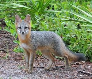
The photo below is a grey fox for comparison. Coyotes are taller and weigh more than foxes; in our area sometimes weighing up to 30 pounds, whereas a fox may be closer to 12.
Grey fox. Both grey and red foxes are much smaller than coyotes. (Public photo.)
Should we be scared? I don’t think so. We just need to be smart, coy and cautious, like the coyote.
Many Native American myths laud the craftiness of “coyote” and often in Native American mythology, he is so respected, he is portrayed as the “Creator.” He is respected for being “ubiquitous,” as he is so successful, “he appears to be everywhere at once,” or “seems to appear everywhere at the same time.” He is not to be outsmarted.
One thing for certain, now that coyote is here, chances are, he will not go away. We must learn to live with him by keeping our distance, not leaving pets out for long periods unattended, in the evening or early mornings, and by not feeding him. He is smart enough to feed himself.
It is said we all have a bit of fear in our inner most nature, as the collective memory recalls the earlier times of fires and wolves, but then humankind tamed the wolf and hence today, we have “man best friend,” our dogs.
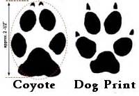
Coyote/Dog tracks
Remember that the coyote is related to dogs if you see him, and if you look him in the eye ask for a sliver of his adaptability and success surviving on an ever changing planet and an ever changing Indian River Lagoon.
I added this photo from Dr Gary Goforth 8-13-15 that was taken this February in Foxwood off 96 A in Martin County.
MOULTRIE DIGITAL GAME CAMERA G. GoforthMOULTRIE DIGITAL GAME CAMERA G.Goforth
_______________________________
I added this link on 8-13-15 written by my classmate Angeline Scotten whom I met last week at the UF Natural Resouces Leadership Institute. She is an expert on the subject of coyotes for the Florida Fish and Wildlife Commission. This article was written for Hernando County but certainly applies to us as well. I found it very informative. (http://hernandosun.com/coyotes_in_hernando)
I taught middle and high school for many years, and I still have numerous friends in the profession. Last week, I received a phone call from teacher, Maureen Breslauer, whose son now attends Bessey Creek Elementary School in Palm City. She asked if I’d like to be filmed by the school’s media specialist, Kelly Middleton, creating a River Kidz public service announcement, as the school, headed by outstanding, Principal Defenthaler, has been learning about river issues and were having a T-shirt day. I was grateful to Maureen for the opportunity to share the concept of “River Kidz” through the morning news. The product reminded me of who I am “most,” at heart, a teacher, and very funny in that in “a moment,” I became the “River Lady.” We did it in one take! For any you who watched MrRoger’s Neighborhood growing up, I think you’ll get a kick out of the video.
*River Kidz, a division of the Rivers Coalition: (
Captured melanistic bobcat from Martin County (Photo courtesy of Busch Wildlife Center, 2007)
The Martin County Difference” is an expression that one often hears from locals that means exactly what it says, “things are different here…”
Not only are the different, they are exceptional. We have the beautiful St Lucie River and Indian River Lagoon, a four story height limit, a strong urban service boundary, great public schools, a strong fertilizer ordinance, public beaches and black bobcats…
When I was a kid growing up in Stuart, one sometimes heard stories from the kids that lived in Indiantown or Palm City about “black panthers.” And someone who had seen them would swear on their mother’s grave this to be true. Supposedly these stories had been around for many, many years coming down from parents and grandparents.
More recently in 2008, my first year on the Sewall’s Point commission, the town had at least three “normally colored” bobcats and multiple kittens. The sightings were very exciting but scared some residents who had moved here from up north so I started reading about bobcats in great detail. Eventually we had Dan Martinelli of the Treasure Coast Wildlife Center speak before the commission and things calmed down but my fascination with these beautiful creatures did not.
I talked about bobcats a lot during this time and in the course of a discussion, one of my husband’s physician friends who lived in Palm City, with great excitement told a story of seeing a black bobcat in Palm City walk across his yard. That same year one of the Guatemalan landscape workers in the town, knowing I loved animals, struggled wide eyes to tell me about the black panther he had seen walking along a fence, close to Lake Okeechobee and the St Lucie Canal, that he had seen while fishing with his son.
According to my reading there have been more reports of melanistic bobcats in Martin County than anywhere else in the country, mostly near the area of the St Lucie Canal, Lake Okeechobee and Loxahatchee.
If you want to find these reports, google “melanistic bobcats martin.” These posts are not entirely scientific but they are documented. They say there have been sightings for the past 80 years.
Although I never seen a black bobcat, popular lore says the exist, I believe it, and it’s certainly better documented than Sasquatch who many of my high school friends claimed to see too.
What an incredible place to live! The “Martin County Difference!”


