I walked out of the hotel and asked the staff person by the door if he could point me in the direction of the Santa Fe River.
“It’s just on the other side of the road,” he said pointing to Alameda Street.
The man’s name was Ben, and he told me he grew up in the area. “When I was a kid the river was higher and flowed, but now it’s not much more than a trickle.”
I asked him if there was any wildlife in the river. He looked down. “No, not since long ago when they dammed it creating a reservoir back in the 1943.”
Before Ed and I left Santa Fe, New Mexico we decided to drive up and see the reservoir located near the Randall Davey Audubon Center at 1800 Canyon Road. When we got there it was closed, and had been since 1932, in order to protect this precious watershed.
When I pulled up information on the Nichols Reservoir, it said the City of Santa Fe through the Nichols Reservoir and the McClure Reservoir, further up the Sangre de Cristo Mountain Range, have the right to store up to 4000 acre-feet combined for their city’s use. However, the Rio Grand Compact controls 2,939 acre-feet of the capacity depending on the water levels in the Elephant Butte Reservoir…so if Butte is low, the city is obligated to release water from the Nichols Reservoir to supply Colorado and Texas…
I turned to Ed and said, “if I’m not mistaken, over many years the Army Corp has easily discharged over up to 5000 cubic feet per second and that is that is over 9000 acre feet a day- for months at a time- of fresh water Lake Okeechobee discharges into the St Lucie River/Indian River Lagoon. In 2013, it was over 5700 cubic feet per second for weeks and weeks, and S-80 can release up to 16,900 CFS or 33,520 acre feet per day if necessary.”
What a waste! And those people in New Mexico are fighting over “crumbs.”
Prior to the 1970s, we used to dump sewage directly into the ocean; now we make fertilizer out of our own human waste and spread it on agricultural lands throughout our state. When it rains, nutrients and metals run right back into our estuaries….is this the answer, or another disaster? What are our options?
If you live close by, please attend this Thursday’s Rivers Coalition meeting to learn more. It was Mr. Gary Roderick who inspired me in 2008, when I was a new commissioner for the Town of Sewall’s Point, to take a deeper look at the causes of environmental destruction of our rivers. He is a knowledgeable and versed having worked both in government and as an environmental consultant.
Please join us!
Below, I am including two former blog posts on the subject: 1. Drowning in Our Own Human-Excrement-Fertilizer; and 2. Spreading Refined Human Waste on the Lands, “Biosolids,” St Lucie River/Indian River Lagoon.
Drowning in Our Own Human-Excrement-Fertilizer, SLR/IRL:
Informational links and summary of where name biosolids came from:
“As public concern arose about disposal in the United States of increasing volumes of solids being removed from sewage during sewage treatment mandated by the Clean Water Act, the Water Environment Federation (WEF) sought a new name to distinguish the “clean,” agriculturally viable product generated by modern wastewater treatment from earlier forms of sewage sludge widely remembered for causing offensive or dangerous conditions. Of three-hundred suggestions, biosolids was attributed to Dr. Bruce Logan of the University of Arizona, and recognized by WEF in 1991.” The story of “biosolids” WIKI
TCPalm’s Elliott Jones reported this morning that Stuart has received a whopping 11.30 inches of rain just so far this month! (The average being 7.14.)
Although due to the recent drought, the ACOE/SFWMD are not dumping Lake Okeechobee through Canal C-44, canals C-23, C-24, C-25, and areas along C-44, as well as our own basin, are draining right into the St Lucie River/Indian River Lagoon. Very little of this water is cleansed before it enters and thus is damaging to the eco system. Next time you see water draining through a grate in a parking lot, think about this. Remember too that before the major canals were constructed the 1900s, the river received less than half the water it gets every time it rains today.
SLR at “Hell’s Gate” looking at Sewall’s Point, Sailfish Point and the St Luice InletDrainage changes to the SLR. Green is the original watershed. Yellow and pink have been added since ca.1920. (St Lucie River Initiative’s Report to Congress 1994.)
The aerials below were taken 6-13-17 by my husband Ed Lippisch and pilot Dave Stone. It is important to monitor the river all of the time so we can view changes.
“Rain stained” we are; please remember not to fertilize during the rainy season. The birds on Bird Island will appreciate it! (http://befloridian.org)
TC Palm, Elliott Jones, 6-19-17Bird Island, IRL east of Sewall’s PointBird IslandIRL St Lucie Inlet and Sailfish PointSailfish Flats, IRLCrossroads, confluence SLR/IRL off Sewall’s PointSpoil Island off Sailfish, bird also roosting here!Sick looking seagrass beds in IRL looking south towards Jupiter Narrows““SL Inlet near Sailfish Point, no black plume but darker colored watersJupiter Island’s state park at St Lucie InletSailfish PointSt Lucie Inlet looking southinlet againClear ocean water at jetty, St Lucie InletLooking back to St Lucie Inlet mixed colored waters but not black as with Lake O water releasesSt Lucie Inlet between Jupiter Island’s state park and Sailfish Pointinlet againLooking north to SL InletJettyHutchinson Island and Sailfish Flats in IRL. Sewall’s Point in distance.Parts of the Savannas near Jensen , IRL and Hutchinson Island in distanceSavannas State Preserve Park
Canals draining water into SLR/IRL after rain events:
Advocacy has many faces, but none perhaps more powerful than a handwritten note or letter. Why? Because it takes effort; because it is thoughtful; and because it is old-fashioned, rare, and special. My mother taught me this…
In a world where furious Tweets and Facebook posts, or better yet, a Snapchat allows one to “live in the moment and then erase it,” we are surrounded by communication that holds impermanence. The hand written note leaves a lasting impression… especially in the “rough and tumble,” yet traditionally based world of politics.
Mind you, your note or letter need not be long; it must just be sincere.
I am asking you to please get out your stationery and write Speaker of the House, Richard Corcoran, and ask for support of House Bill 761 in matching format to updated Senate Bill 10. Right now this bill is being held; should finally be heard in committee soon; and of course, is certainly being negotiated with the Senate President Joe Negron.
Remember that Representative Corcoran is one of the authors of “Blueprint Florida” whose goal it to “leave a legacy for future generations and overcome the corruption and influence of special interests”. I wrote about this the day before yesterday.
Over the past hundred years, agricultural special interests, with little or no thought of the long-term consequences, have absolutely decimated one of the greatest wetlands of the world and thus its wildlife… our Florida Everglades.
House Bill 761 and Senate Bill 10’s goal of reducing the damaging discharges from Lake Okeechobee to the St Lucie River and Indian River Lagoon, Caloosahatchee, and sending clean water south to Florida Bay and the Everglades is a legacy not only of a lifetime but, for a millennium.
Please write Speaker Corcoran today and ask for support:
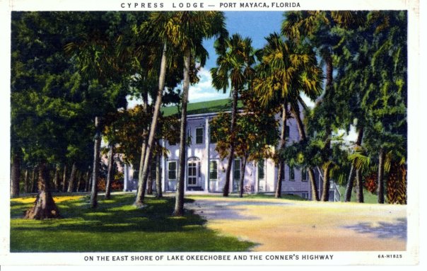
Historic Postcard courtesy of historian Sandra Henderson Thurlow.Back of post card
If one drives to end of Kanner Highway adjacent to the C-44 Canal connecting the St Lucie River to Lake Okeechobee, there is a gem to see. A place that will take you back to an earlier time. The name of this place is the “Cypress Lodge,” in Port Mayaca.
According the “History of Martin County,” this beautiful lodge first opened its doors in 1938 and is *now operated by Mr and Mrs Charles Dorrell functioning as a resting stop for tired motorist crossing the state from north to south, or east to west.”
Page 253 reads: “The lodge, boasting an outstanding cellar, is colonial in design, built originally as a tavern, has been operating ever since. The two-story all cypress building with a large dining room, is staffed mostly by residents of Pahokee, Canal Point, and surrounding towns. It is said more people work in Port Mayaca than live there.”
Just last week I learned that friend, and long time Stuart resident, Elsie Jean Stewart, has deep ties to the property as her parents were married there. She recently shared with me a wonderful family photo of the young couple. Their tremendous smiles in black in white were full of color. What days these must have been…
I recently drove out past the lodge on my way to Belle Glade while daydreaming what the area was like as in the mid-1800s between Seminole Wars. I saw a giant cypress forest full of wildlife and there was no dike around the lake, so from horseback, I could see over the wide expanse of Lake Okeechobee….
Those things are gone and the lodge was built later, but it is still connected. I have been curious to see the structure as I have been missing it on my recent drives to Belle Glade. On my last trip, I figured out that at some point the historic Connors’ Highway had been rerouted so now at the Lake, one must turn north rather than south to see the familiar structure.
When I found the lodge, I took some photos to share. Still beautiful. Still timeless. I believe today it is a private residence. Thankfully it is still here and remains a gem of Martin County’s fascinating history around Lake Okeechobee.
The Cypress Lodge and Port Mayaca are located west near S-308 at Lake Okeechobee. You can see the C-44’s connection from the Lake to the South Fork of the St Lucie River/Indian River Lagoon.
2-18-17: Correction!
Today I figured out, thanks to an article by the Luckhardts, that although not mentioned in the “History of Martin County” on page 252-3 , it was Paul M. Hoenshel of Miami who originally built and operated the lodge. Hoenshel is the grandfather of Elsie Jean Stewart whose “parents were married in the lodge” that I mention…. Jacqui
“Once You have tasted flight you will walk the earth with your eyes turned skyward, for there you have been and there you will long to return.” Leonardo da Vinci (1452-1529)
I would like to thank former mayor of Pahokee, JP Sasser for on November 29th guiding me through a seven hour tour of the Glades! At first you may think JP and I are unlikely “friends.” Actually we have something very much in common in that we have both been mayors of small Florida cities.
Yes, there are also a few serious things we don’t have in common such as our opinion regarding land purchase in the Everglades Agricultural Area, (EAA), for a reservoir to alleviate the destruction of the St Lucie River. Also, Sasser has written extensively about concerns regarding the direction of the Rivers Coalition. I have been on the Rivers Coalition Defense Fund for six years. Mayor Sasser and I have not always been on the same page. For me this is O.K. JP and I having differences of opinion shouldn’t preclude working together. At this point in my river journey, I am going to do all I can to build relationships. To find common ground. “Common muck” should I say?
Anyway, enough politics. My tour was awesome! For this post, I will just concentrate on Pahokee.
JP and I met at Canal Point, at the USDA Sugarcane Field Station that dates back to 1920 about ten miles south of the Martin County/Palm Beach County line at the WPB Canal.
Pahokee has about 6000 residents. It has beautiful new schools. Many of the lands are owned by family farmers and the Fanjul family. The population is about 80% black and 20% white. Everyone I met was friendly and happy to see me.
Locals fishing at marina
JP asked me where I wanted to go. I asked him to take me to the Pahokee Marina and Tiki Bar that he so famously worked for during his mayorship. This marina is within view of Port Mayaca in Martin County. JP’s dream was that this marina would become the basis for economic development and diversity of Pahokee. The city desires economic development. (http://www.mypalmbeachpost.com/news/business/guy-harveys-resort-chain-eyes-site-in-okeechobee-c/nmwGw/)
I learned that Pahokee unlike much of the Glades is thirteen feet above the lake. It is high ground. The town is just a few miles long and 500 feet wide right along the dike. One sees dike, houses, road and then fields…Thus when the ACOE recently wanted to make improvements and “go out 500 feet out from the dike” they would have basically had to had to knock down the city.
I learned that much of the lands close to the Lake were covered with Apple Custard Trees that had been removed in the early 1900s and thus the lands have excellent deep muck soil that grows not only sugarcane, but sod, corn, vegetables, and supports tree farming. Pahokee is known as “Muck City.”
JP then took me off the beaten track to see his horses and donkeys. So here is something else we have in common. A love of animals!
We drove on…JP showed me the remains of the Pelican River which led to Pelican Bay that I had read about in my book. This was the area where the Palm Beach Times reported over 400 dead after the 1928 Hurricane. I tried not to imagine…
We then drove to Pahokee’s original graveyard that had to be moved along with its resting bodies to Port Mayaca in Martin County after the 1928 Hurricane. There was a plaque that listed those who had been buried there. A sad thought, but here is another way Martin County and the Glades are connected.
We visited the airport. Very nice. Right along the lake. In fact this area was once lake bottom. Bizarre. Hmmm…My husband Ed would like this airport I thought. More possibilities for economic development?
Again back to the dike. It always goes back to the dike…
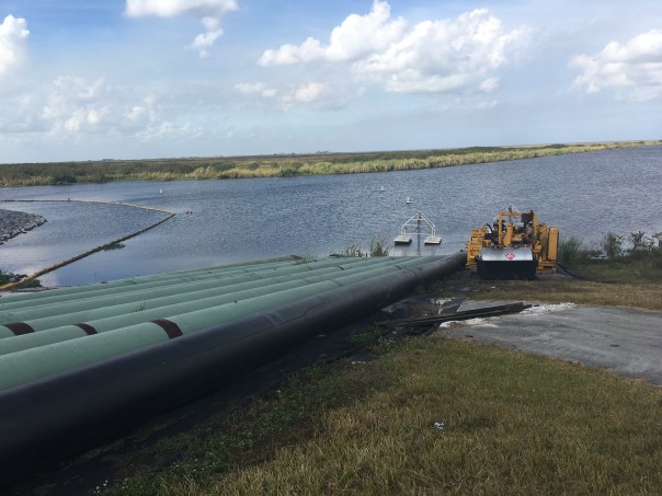
We checked up on ACOE repairs where they had draped the pipes carrying water to the fields over the dike like spaghetti and then JP took to me to lunch….
Part #2 will be entitled: “The Best Fried Chicken of My Life.” Please see photos below.
JP at Pahokee MarinaDriving on road atop the dike by marinaView from dike looking south. Homes stand right next to the dike.Old Pelican RiverTree Farm looking from dikeJP’s horese and donkeys
Original Pahokee graveyard at base of dike
Old GraveyardPahokee’s nice new roads with lovey houses on right and fields on other side of roadCanal and control structure to fieldsLocation of airport, once lake bottom
JPRepair of dike ACOE with water for irrigation from lake over dike so they can get to culverts
Today I will continue my series “Who Owns the Land South of Lake Okeechobee? Mapping out the Future of Water.” Hurricane Matthew caused a slight interruption, but now we shall continue. 🙂
Here we go!
Number two on the TCRPC map (above) is Okeelanta Corporation. “Okeelanta is a division of Florida Crystals, the word is a combination of two made into one. “Okee,” coming from “Okeechobee,” and “lanta,” coming from “Atlantic.” Cleverly named for a location between Lake Okeechobee and the Atlantic Ocean. Okeelanta was a historic town founded by writer and politician Laurence E. Will’s father. The town stood about one mile below South Bay. It was destroyed in the 1928 Hurricane: http://www.pbchistoryonline.org/page/okeelanta
I’m not sure if the company Okeelanta is named after the town, but I believe it was bought, and I know it is now owned by the Fanjul family of Cuba who owns Florida Crystals. As many of us know, the Fanjul family came to South Florida because of Fidel Castro’s 1959 Marxist Revolution. The family moved to Florida along with other wealthy, dispossessed families. Here with the support of the US Government the Fanjuls rebuilt their fortune as the US grew to be a leader in the world sugar trade, at the expense of the Florida Everglades.
In regards to the map, it must be noted that compared to US Sugar Corporation, the Fanjul family are relative”newcomers.” This is why their land holdings are further south of Lake Okeechobee. They acquired lands as the industry expanded after 1960.
Sometimes I say “until the Cuban Revolution there were only 100,000 acres of sugar cane in the EAA.” This is probably off, but you get the point. As Laurence E. Will in his historic book noted in a previous post: “After the Cuban Revolution, for a short time our government permitted the unrestricted panting of sugar cane…”
Again I stress that the expansion of these lands by the US Government is what allowed this area to be convered from Everglades to sugar fields, and it is only our state and national governments that can encourage and fairly compensate land owners for lands purchased in the EAA to allow water storage in an area that should never have been 100% developed in the first place. We have to encourage land owners to please be a part of the solution of allowing storage of excess water and helping more clean water move south…
According the TCRPC map Okeelanta owns 86,793 acres of land in the Everglades Agricultural Area, (EAA.) A lot!
I have colored in the #2s with orange highlighter so you can see these lands more clearly and how the intersect with Senator Joe Negron’s circles for possible proposed land acquisition. Remember that 9 days ago I colored in United States Sugar Corporation’s (USSC) lands in purple crayon. They are #1.
So now we can clearly “see” what lands are owned by USSC and by Okeelanta.
“Okeelanta Corporation, a sugarcane company, engages in farming, milling, packaging, and distributing sugar cane. It has a 67,000 acres facility that includes cane fields, a mill, refinery, packaging and distribution center and a power plant. The company was incorporated in 1984 and is based in West Palm Beach, Florida. Okeelanta Corporation operates as a subsidiary of Florida Crystals Corporation.”
As we shall see in future posts, the Fanjul holdings have various names, thus they own more land than noted in the map above. Like them or not, the family is clever just like the name “Okeelanta” and infamous for their political influence. The two most well known brothers are noted for ties to different political parties: Alfonso Fanjul, Democratic Party while Pepe, contributes to Republican Party. For the record the other brothers names are Alexander and Andres. And they have a sister. Her name is Lillian Banjul Azqueta and she is president and founder of New Hope Charities.
As controversial as the family is, they do a lot of good for the poor Glades communities and they own what we want. We must work together for a better water future for Florida that includes our St Lucie River/Indian River Lagoon.
Post Hurricane Matthew, I am sharing Dr Gary Goforth’s “Updated Lake Okeechobee Discharges to the Estuaries and Everglades,” dated yesterday, October 10, 2016 as sent to state and local officials, as well as the press. Many helpful visuals are attached.
Dr Goforth continues to lead in documenting the destruction of what was once lauded as North America’s “most biodiverse estuary,” our beloved St Lucie River/Indian River Lagoon…
Through shared knowledge, we advocate for a better Florida water future.
More than 204 billion gallons of polluted Lake water has been discharged to the St. Lucie (25% of total Lake discharges); more than 456 billion gallons of polluted Lake water has been discharged to the Caloosahatchee (55% of Lake discharges). By contrast, only 20% of Lake discharges has been sent to the south, with only 6% sent to the STAs/Everglades.
Ag runoff continues to contribute significant amounts of flow and pollution load to the St. Lucie: 39% of flow, 53% of total phosphorus and 42% of total nitrogen.
Gary
I added a chart comparing monthly Lake flows to the STAs – 2016 releases to STAs has been significantly less than 2014 and 2015.
The Florida Water and Land Conservation Initiative, Amendment 1, is more than just hope. It will help save our Indian River Lagoon. (Photo Jenny Flaugh, St Lucie River sunset.)
Amendment 1, the Florida Water and Land Conservation Amendment is the voice of generations of people, people who have been diligently working to restore and protect the natural water and land resources of Florida. These same people were, in essence, robbed by their government. The Land Acquisition Trust Fund, Florida’s conservationists, ethical business people, and protectionists, are not going to allow this to happen again.
Over many years, governors and legislative bodies have taken or “swept” trust fund money from multiple interests. This was done by the Bush administration and more recently by the Scott administration. Through out the years, Democrats have done it too. It is a long standing, accepted way of “ruling.” And yes, there are a hundred “good” reasons to do so, if one is a politician, like the financial crisis of 2008, and the fall out afterwards.
Nonetheless, it is wrong. Immoral. Governments should not call the hard collected, established, monies of special interest groups TRUST funds if they are legally allowed to take them when times get tough. This mode of operandus takes advantage of and confuses a public that has purposely been uninformed by its leaders. It simply is not good government.
This is where Amendment 1 comes in. To restore a program for lands and now waters in our state, one that cannot be taken away.
On April 16th at 2pm, at Indian Riverside Park, supporters of the constitutional amendment, #1, FLORIDA WATER & AND LAND CONSERVATION INITIATIVE (2014) will hold an educational forum to educate on why it is critical that we all vote yes on this amendment in November.
I have provided the formal wording below so you can read the document, but I will summarize why it is a good thing:
1. First, it does not allow future monies to be commingled with the General Revenue Fund of the state. (taken/stolen/redirected by the state legislature)
2. Second, it supports a committee that has the ability to use funds collected from 33% of documentary tax stamps (real estate charges the state collects form homebuyers) to purchase lands across the state including the Everglades Agriculture Area, (EAA) the Everglades Protection Area, (EPA), water areas, conservation easements, wetlands, forests, fish/wildlife habitat/management areas, drinking water lands, lands protecting water quality and and quantity for springs, rivers, streams, spring sheds, recharge areas for groundwater/aquifers, recreational lands, open spaces, rural landscapes, farm and ranches, and historic or geologic sites.
Here is the legal language:
SECTION 28. Land Acquisition Trust Fund. —
a) Effective on July 1 of the year following passage of this amendment by the voters, and for a period of 20 years after that effective date, the Land Acquisition Trust Fund shall receive no less than 33 percent of net revenues derived from the existing excise tax on documents, as defined in the statutes in effect on January 1, 2012, as amended from time to time, or any successor or replacement tax, after the Department of Revenue first deducts a service charge to pay the costs of the collection and enforcement of the excise tax on documents. b) Funds in the Land Acquisition Trust Fund shall be expended only for the following purposes: 1) As provided by law, to finance or refinance: the acquisition and improvement of land, water areas, and related property interests, including conservation easements, and resources for conservation lands including wetlands, forests, and fish and wildlife habitat; wildlife management areas; lands that protect water resources and drinking water sources, including lands protecting the water quality and quantity of rivers, lakes, streams, springsheds, and lands providing recharge for groundwater and aquifer systems; lands in the Everglades Agricultural Area and the Everglades Protection Area, as defined in Article II, Section 7(b); beaches and shores; outdoor recreation lands, including recreational trails, parks, and urban open space; rural landscapes; working farms and ranches; historic or geologic sites; together with management, restoration of natural systems, and the enhancement of public access or recreational enjoyment of conservation lands. 2) To pay the debt service on bonds issued pursuant to Article VII, Section 11(e). c) The moneys deposited into the Land Acquisition Trust Fund, as defined by the statutes in effect on January 1, 2012, shall not be or become commingled with the General Revenue Fund of the state.
The local forum on April 16th is sponsored by the Treasured Lands Foundation and the Martin County Taxpayers Association, the event features a host of elected officials and environmental experts, including U.S. Rep. Patrick Murphy; Eric Draper, executive director of Audubon Florida; Mark Perry, executive director of Florida Oceanographic Society; Sarah Heard, chair of the Martin County Commission; Troy McDonald, mayor of Stuart; Jacqui Thurlow-Lippisch, commissioner of Sewall’s Point; Eve Samples, Stuart News columnist; John Nelson, president of the Martin County Audubon Society and Maggy Hurchalla, leading environmentalist.
I hope this blog has been helpful as sometimes all this can be convoluted and confusing.
I encourage you to attend the forum on April 16th as I will be speaking along with others. More important, in November, please vote for Amendment 1, the Florida Water and Land Legacy.
This amendment is the voice of the people and is truly tailor made to, over time, help our ailing St Lucie River and Indian River Lagoon.
OVERVIEW: The water system for South Florida starts in the chain of lakes, just south of Orlando. This water runs south, along the canalized Kissimmee River, making it to Lake Okeechobee in just a few days, a trip that took months before the snake like river was turned into a canal by the Army Corp and the State of Florida in the 1960s. The now unfiltered water is full of pollutants, nitrogen and phosphorus it picks up along the way.
The giant lake, once open to the south to nourish the Everglades, has been closed off by a dike since the late 1920s. Thus when the lake water rises too high for the “safety” of agriculture, mostly sugar, south of lake, the water is diverted east and west through the estuaries: the Caloosahatchee and the St Lucie.
From this diverted water, billions of gallons goes to tide through the Gulf of Mexico on the west, and the Atlantic Ocean on the east. Along the way, the estuaries are destroyed of all life and the economies of the surrounding cites are decimated.
At South Florida Water Management meetings, stakeholders fight over water rights…
For the St Lucie, dumping billions of gallons to tide, there are toxic algae warnings from the health department and state; salinity is so low oysters and seagrasses have died off by 99%; wildlife suffers and dies; business and recreation are at a standstill; children go back to school speaking of the “lost summer…”
Yes, the estuaries have been the dumping ground for Lake Okeechobee since the 1920’s when the estuaries were canalized by the State of Florida and the Army Corp of Engineers…
And yes, Martin County residents have fought against this destruction before, but this time it is different…
This summer a “Riverlution” began….
Right now, this “Riverlution” is building and organizing….
This new blog is dedicated to the “Riverlution” of Martin County, Florida, 2013. May it educate and inspire you….as you inspire me!
For the Estuaries,
Jacqui Thurlow-Lippisch, Commissioner, Town of Sewall’s Point


 Today I will continue my series “Who Owns the Land South of Lake Okeechobee? Mapping out the Future of Water.” Hurricane Matthew caused a slight interruption, but now we shall continue. 🙂


