Tag Archives: historic map

The Everglades’ Boundary of 1910, and Today’s Toxic Lake Okeechobee, SLR/IRL

Historic map, Palm Beach Farms Company Lands ca. 1910 showing “edge of Everglades.”  Archives, Lawrence E. Will Museum of the Glades, Belle Glade, Fl.

Looking back gives us perspective when looking forward.

This old map showing the Palm Beach Farms Company Lands is interesting as is shows where people saw the “edge of the Everglades” when they were first developing around 1910.

Today it is hard to judge where we are and what “was” the Everglades…Some of us are literally “in it.”

Looking back, it is easy to see how  after over 100 years the waters of Lake Okeechobee are becoming more and more “toxic.” Kind of like a fish tank that can never be cleaned out….

One has wonder if the developers of the Everglades ever considered what would happen to the lake by building and developing farm lands right in the way of the natural flow, and then really blocking it by eventually putting a dike around the lake? In this map, the push was to develop lands further west beyond the eastern ridge…Think all all the development today out west beyond the ridge and into the historic Everglades!

Perhaps in their wildest dreams the early developers  would have never envisioned how many people live in south Florida today. Maybe they didn’t care. In any case, today we all here in South Florida are connected somehow to Lake Okeechobee, Florida’s  “liquid heart,” for drinking water, recharge, recreation, property values, and our health.

Over our history the human spirit has overcome greater threats than toxic algae; I am confident we will once again.

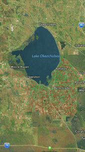
SFWMD satellite map South Florida. Red lines denote historic Everglades.
SFWMD
Lake O eastern shoreline, Port Mayaca, 7-21-17, JTL
Lake O, 7-21-17


LINKS:

Lawrence E Will Museum of the Glades: https://www.museumoftheglades.org

https://www.facebook.com/lawrenceewillmuseum/

Lake O acres today?/451,000: http://www.lakelubbers.com/lake-okeechobee-107/

Township and Range? the squares: http://www.jsu.edu/dept/geography/mhill/phygeogone/trprac.html

Palm Beach Farms Company Lands-History (-bottom of blog by Ginger Peterson, Boyton Historical Society: http://www.jsu.edu/dept/geography/mhill/phygeogone/trprac.html

Remembering Lake Okeechobee’s Moonflower This Easter, SLR/IRL

Florida map 1500s
Moon flower, public image

Florida translates to “Flowery Easter” and was christened such by Ponce de Leon in 1513. Yes, we were a “land of flowers!”

Everglades Wildflowers: http://www.wildflowersearch.com/search?oldstate=gmc%3A25.32%2C-80.93%3Bgms%3A12%3Blocation%3AEverglades%3Belev%3A1%3Btitle%3AEverglades%20Wildflowers%3B

The wildflower I would like to remember in “all its glory” this Easter is the moonflower whose sweet fragrance used to fill Lake Okeechobee’s shores.

David Troxtell of the Marie Selby Botanical Garden in Sarasota writes:

Not too long ago, Florida’s giant Lake Okeechobee would fill with rainwater and flood its southern banks every year during the wet season. The water’s slow journey through the Everglades’ 100-mile long “river of grass” and out to Florida Bay and the Gulf of Mexico would take months.

At the very beginning of this journey would have been a floodplain covered in a massive pond apple forest, completely blanketed in moonvine. Pond apple is a native tree which grows in regularly flooded areas, and is a preferred host for the moonvine. It has also become a rare sight in the state outside of the Everglades due to development, mostly agriculture.

The massive forest of moonvine and pond apples covering 32,000 acres along the southern edge of Lake Okeechobee was destroyed in less than a decade…” (http://selby.org/moonvine-morning-glory-family/)

What is exciting is that there is a resurgence of interest in reestablishing the pond apple also known as the custard apple which would inadvertently include the moonflower. The Art Marshall Foundation worked on such, but many were destroyed in the hurricanes of 2004 and 2005. Sarah Brown, a local South Florida photographer, has a show presently at the Lawrence E. Will Museum of the Glades. Many of her photographs feature the few remaining custard apple trees and moonvines. Zachariah Cosner, a student at University of Miami, is writing a book on the subject and I will be featuring his work more in the coming months.

So on this sacred Easter, remember, there is hope of recovering some of Florida’s wildflowers for which we are named. May we once again be Florida, “land of flowers.”

Sarah Brown Images, http://www.sarahbrownimages.com

Nativeg8r, Pinterest image of moonflower
Moonflower center, Rebecca Fatzinger

Lake Okeechobee 1874,1974, 2074? SRL/IRL

Map from Fred Ober's 1874 expedition.
Map from Frederick Ober’s 1874 expedition.

(For even more insight watch this Time Flight Video by Todd Thurlow, https://youtu.be/sJkMOIqjr_I?t=1m7s “South Bay and Lake Okeechobee”)

Today we continue looking at parts of a 1974 text entitled: “Environments of South Florida, Present and Past,” by Patrick J. Gleason, lent to me by Dr Gary Goforth.

Today’s map of study was created by Frederick A. Ober.

Fred Ober was a man who once ran a shoe shop, but one day, with a dream in mind, literally “threw off his shoes.” He decided to go on an adventure and make something more exciting of his life. In 1974 he visited and documented our Lake Okeechobee and surrounding Everglades.

Our text ironically, looks at Lake Okeechobee 100 years after his visit–published in 1974.

To look at the map and see such notes as “commencement of cypress belt with sandy shore” along the east side; “custard apples, and marshy lands, —-sand beach on the south side”; and “palmetto ridge and Kissimmee Prairie in the north,” really take one to another world.

—A world that basically does not exist anymore.

We scraped it clean. We rearranged it. We built it out. We drained it. We diked it.  We planted seed. We erected houses. Maybe one day the young people will try to put some of it back. It must have been spectacular.

What will it look like in another 100 years? Will today’s Google map below appear as obsolete as Ober’s? What do you think? Is there a way to go back? Envision 2074.

....
….cover of text, 1974
south rim
south rim
Kissimmee River area north
Kissimmee River area, north
NE area of lake
NE area of lake
the lake up close
the lake up close
Today's Google map, 2016.
Today’s Google map, 2016.

Frederick Ober: (https://en.wikipedia.org/wiki/Frederick_A._Ober)

Cane Slough? Maidencane not Sugarcane! St Lucie River/Indian River Lagoon

The J.J. Pichford Family camping at Cane Slough ca. 1918. (Archives, historian, Sandra Thurlow.) photo copy courtesy of Sandra Henderson Thurlow.
The J.J. Pichford Family camping at Cane Slough ca. 1918. (Archives, historian, Sandra Thurlow.)
1909-11 ACOE Drainage map Kissimmee and Caloosahatchee Rivers. (Courtesy  historian Sandra Henderson Thurlow.)
1909-11 ACOE Drainage map Kissimmee and Caloosahatchee Rivers. (Courtesy of Stephen Dutcher and historian Sandra Henderson Thurlow.)
Google Map image includes much of what was Cane Slough in the historic map.
Google Map image includes much of what was “Cane Slough” in the historic map.

In these parts” it’s very important to know the definition of “cane!”

Yesterday’s blog referred to “Cane Slough”on the historic 1909 map by the Army Corp of Engineers.  I made a joke about “cane” not meaning “sugarcane” as one may first think when hearing the word “cane” today. After publishing the post, I learned even more about “cane” from a long time family friend and wanted to share this with you today.

Fred Taylor informed me that “cane” is referring to “maidencane,” and that there are still places where  maidencane grows today, it is great for wildlife and also the cows eat it. I think I had thought that MAIDENCANE was a hard-rock band…According to the Florida Wildlife Commission:

Maidencane: This vaulable and common native can form large stands in the water or even on dry banks. It may be confused with torpedo grass, para grass, cupscale grass or blue maidencane. It provides food, protection and nesting materials for wildlife.

Maidencane is a grass. rhizomes extensive; stems to 6 ft. long, narrow, leaning or erect; leaf blades flat or folded, wide, to 1 in. wide, to 12 in. long, tips pointed, usually smooth; sheaths loose, hairless to hairy; inflorescence erect, narrow, spike-like, closed, 4-12 in. long, ascending branches pressed to main axis; spikelets stalked, flowers to 1/8 in. long, green, pressed against branches. ( FWC:http://plants.ifas.ufl.edu/node/306)

Who is the woman with the rifle in the classic historic photo above? She is Mrs J.J. Pichford.

Mrs J. J. Pichford has just shot a wild turkey for dinner. She is camping at “Cane Slough” around 1918. Her young son nearby, they stand in what is a now developed portion of our St Lucie/Martin County region.

On the back of the photo,  my mother wrote: Wagon Wheel Hammock–Would travel by wagon through White City to the back country where there were no roads. Young Robert would always fear his family would get lost in the wilderness…

Well that wilderness is gone today, and my husband Ed is lucky if I’ve had time to stop by Publix! Times have changed as has our treasured St Lucie River/Indian River Lagoon Region, but apparently there is still some maidencane left if you know where to look. 🙂

Maidencane, public photo.
Maidencane public photo.
The J.J. Pichford Family camping at Cane Slough ca. 1918. (Archives of historian, Sandra Thurlow.)
The J.J. Pichford Family camping at Cane Slough ca. 1918.

Original blog post mentioning Cane Slough: (http://jacquithurlowlippisch.com/2015/06/03/1909-acoe-drainage-map-st-lucie-riverindian-river-lagoon/)

Full map...
Full map…