One of the most rewarding parts of my advocacy is the people I meet, especially the “young people.” As a former teacher, and having no children myself, I feel a special connection. If they ask for advice, I encourage them in every way possible to relay their story and their concerns, uncensored. “Speak out! Speak out for the environment!”
A few months ago, a young lady by the name of Mariya Feldman contacted me. She had been working as a teacher in Pahokee, Florida, and was concerned about the poor air quality caused by the burning of nearby sugar fields and the effects it had on her students’ health.
I have experienced this burning from both the air, and the ground; I was interested in her story.
Burning sugarcane fields in the EAA. (Photo Ed Lippisch and Jacqui Thurlow-Lippisch, 2012.)Well, months later, Mariya contacted me again, this time she had completed her video production. She intermixed her topic of interest, poor air-quality and human health, with the health issues regarding the 2016 toxic algae outbreak in the St Lucie River caused by discharges from Lake Okeechobee. In the months previous, I had spoken openly to her and allowed her to record my interview and use it in her video. My interview, interwoven with others is included. Mariya has collaborated well to get her point across. She is a modern day student investigative reporter. I am excited to see where her talents, technological abilities, and passions will take her in the future.
I feature her work today in a You Tube Video below. Please watch it. It will make you think!
I thank Mariya and all the young people working for a clean and healthful environment for the next generation. Never give up. Never stop speaking up! It is up to us for sure.
We all know that young people are the largest key to a “better water future” for our great state of Florida. Recently I opened my mailbox to find the “Florida Coastal Law Review’s Special Symposium Issue: A look into the 2017 Florida Constitution Revision Commission/Fall Issue, Volume 18.” It is very excited to see what topics the students are covering. I read the whole thing! All of the articles are powerful expressions. My favorite? “Sugar, Politics, and the Destruction of Florida’s Natural Resources,” by Jaclyn Blair.
After such a difficult few weeks watching the state legislature pass the ball back and forth and finally catch SB10 and HB761, and then the false cry that Florida Forever could not be funded, the Law Review publication really lifted my spirits. I was so excited that I decided to call the law school, garnering more information and received permission to share.
The best way I know how, and with my limited time today, I am just going to photograph the article and post it. Even if you read the first few pages, you will be impressed. I have a better format, but cannot post PDF format on my blog. Email me if you’d like a PDF or call the law school at 904-680-7700. The Editor-in Chief, Dylan W. Retting, is a great help.
Close up toxic algae, SLR, 2016, JTLIn closing as I’m off to Panama City, more than anything…more than any bill or any politicking…. seeing young people pick up the torch for our waters and our environment is an inspiration. An inspiration for a true and longer-lasting, “better water future.”
Thank you to the students of Jacksonville’s Florida Coastal Law Review! I am impressed!
Today I share the second paper of guest, Geoffrey Norris Ph.D. I recently shared Blue-green algal blooms in the lakes, rivers, and marine waters of south Florida surrounding Lake Okeechobee.
I must admit, I hesitated publishing this second paper, “Sugarcane and Indians,” as I am sure some may interpret it as “politically incorrect.” I apologize to anyone who may, but I decided to print Dr Norris’ paper because the main message is important.
The message is:
“Is Sugar’s use of ripening stalks with “Roundup” feeding toxic algae blooms and why are lands/waters south of Lake Okeechobee “protected” while ours of the northern estuaries are not? “
You will learn something about this in Dr Norris’ paper below, and I thank him for sharing his work.
In closing, I believe we have something important to learn from history and the Native People of North America; I admire them. They are great warriors and respect Nature, the gift of our Creator. And in the case of the Miccosukee, they “never surrendered” and if I have anything to do with it, neither will we.
..”In the 1960s, I lived and worked as a petroleum exploration geologist in Tulsa, Oklahoma. Subsequently, I spent almost 40 years at the University of Toronto in teaching and research in geology…A geologist by training, I have a specialized knowledge of fossil algae, their ecology, morphology, and distribution. I have published hundreds of scientific papers on fossil algae and related topics.” ~Geoffrey Norris Ph.D.
rosalex@interlog.com
Sugarcane and Indians
Executive summary
The area around Lake Okeechobee accounts for almost half the total production of sugarcane in the United States.
Sugarcane in south Florida is very needy of phosphorus and potassium fertilizers, but nitrogen fixed in the muck soils largely eliminates the need for extra nitrogen fertilizers.
Sugarcane also demands the use of the phosphorus-rich herbicide “Roundup” (glyphosate) several times each year. Firstly, in the fallow season (approximately May-September) to control weeds and allow the sugarcane underground rhizomes to regenerate. Secondly, as the new shoots come through in the Fall to continue weed control. Thirdly, during maturation and harvesting (October through March) glyphosate is applied to “chemically ripen” the sugarcane and improve sugar yields.
Land south of Lake Okeechobee could be used for storage and bio-cleansing of excess lake water. However, the 1997 water quality agreement between the Environmental Protection Agency and the Miccosukee Indians (aka Mikasuki, Miccosuki) states that phosphorus shall not be present in quantities greater than 10 parts per billion, and that no substance shall be present to stimulate algal growth and produce objectionable algal densities in the 300,000 acres of tribal lands in the Everglades south of Alligator Alley.
This legal agreement would suggest that Lake Okeechobee waters destined for southern storage must be cleaned to rigorous standards before discharge into southward flowing streams feeding the Everglades, at least near the Miccosukee tribal lands.
A case could be made for the sugar industry and related agriculture to “clean up its act” to mitigate the effects of heavy fertilizer and herbicide usage on the environment in general and on lake and stream waters in particular.
Sugarcane and Indians
First about nutrients and farm land and how much is planted in sugarcane.
Here are three maps that graphically answer the question about the extent of sugarcane plantations:
A couple of years ago I had the opportunity the fly over the area south of Lake Okeechobee in a light plane at about 1000ft altitude. The extent of the sugarcane is truly mind-boggling. Its plantations surround the entire southern perimeter of the Lake and reach to the horizon. Smaller plantations occur elsewhere around the Lake. It is a very big operation.
Now to the nutrients themselves. I had a great deal of difficulty finding precise information on how much fertilizer is applied per unit area. There were general articles that confirmed that sugarcane is very needy of nitrogen, phosphorus, and potassium fertilizers together with other elements. It is after all a giant grass, so just think how much stuff you have to put on your own lawn to make it grow green! Apparently, in the south Florida area the need to apply nitrogen fertilizer to sugar cane is not so critical because the mucky soils generate their own nitrates through soil microbial activity. However, phosphates must be applied as fertilizer for sugarcane at various times of the year together with potassium etc. But actual numbers were hard to come by, other than that sugarcane is voracious for fertilizers. This is when I stumbled upon some marvellous work that the U.S. Geological Survey has been doing on the extent and the total quantitates of pesticides being applied to farmland across USA. I used their maps of glyphosate (Roundup) as what I thought might be a reasonable proxy for phosphate fertilizer. In other words, if you use Roundup as a weedkiller on crops, then very likely you will be using fertilizer as well. It turns out I was right and I was wrong! First take a look at this summary map for two separate years, 1992 being the earliest year available in this USGS study:
Details are difficult to see in these summary maps but the originals are much clearer. The area around Lake Okeechobee was already in 1992 applying large amounts of glyphosate, and this intensified in succeeding years. What I didn’t understand was why the sugarcane fields should be so needy of weedkiller – fertilizers OK, but why so much weedkiller? It would seem that 25% of the cost of sugar production is due to heavy nutrient need (up to 75 lbs phosphate per acre, with 400,000 acres in sugarcane in south Florida). But weedkiller. Then I dug deeper following your email comments and found out why. Indeed glyphosate is used at least three ways on sugarcane as follows:
Firstly, during the fallow season (approx. May-September 2016) following harvesting, glyphosate is applied to control weeds which would otherwise grow up and choke out the underground cane sugar rhizomes left in the ground to regenerate as the next crop.
Secondly, glyphosate application continues in different amounts as the new shoots come through in the Fall. This is tricky because glyphosate kills just about anything that is green, but careful control can kill the young weeds while not harming – at least not very much – the young sugarcane shoots. Other herbicides are also involved but glyphosate is the big one.
Thirdly, the sugarcane matures and is harvested in the winter months at various times from October through March. During this time the stem of the sugarcane ripens and becomes rich in sugar (sucrose) prior to going to the mill. Astonishingly (to me anyway) it has been found that about a month or two prior to harvesting, another application of glyphosate will help ripen and enrich the crop with significantly more sugar. This process is called “chemical ripening”. Other chemicals can be involved but glyphosate is a popular choice (it got cheaper once Monsanto’s patent expired in the year 2000).
So yes, I think cane sugar farming is being pursued intensively, but I’m not sure how it can be stopped. Its effects on Lake O could be mitigated as discussed in my previous document but stopping an entire industry would be almost impossible to my mind. Cleaning up the sugar industry might be a more realistic aim.
Change of land usage and water flow.
It would be nice to think that Lake Okeechobee water could be redirected southwards along its original historic course on its way to the Everglades. Here’s a graphic of how things used to be:

For thousands of years, water drained from Lake O through a wide series of shallow tributaries and interconnected lakes to the Everglades. It’s unlikely that this could be recreated but certainly use of land south of the Lake for water transport and storage and bio-cleansing of some sort or another would be an improvement. However, it would seem that this is unlikely given the actions of the U.S. Environmental Protection Agency and its agreement in 1997 re the Clean Water Act with the Miccosukee Indians, a tribe which occupies part of the Everglades.
This agreement set out comprehensively water quality standards for the Tribes drinking water, wildlife habitat water, and recreational water (boating, swimming etc). In particular, Section 3 reads:
MICCOSUKEE ENVIRONMENTAL PROTECTION CODE
SECTION 3. Tribal Water Quality Standards
The following minimum water quality criteria shall apply to all surface waters of the Miccosukee Tribe of Indians of Florida unless those water bodies are designated with higher or stricter water quality standards. Stricter standards for a given water body shall supersede these general Water Quality Standards. These standards shall provide a legal basis for including whole effluent toxicity requirements in all federally issued permits.
(there follows a list of 16 physical, biological, and toxicological conditions of which these two are particularly germane):
E. NUISANCE CONDITIONS: Plant nutrients or other substances stimulating algal growth, from other than natural causes, shall not be present in concentrations that produce objectionable algal densities or nuisance aquatic vegetation, or that result in a dominance of nuisance species instream, or that cause nuisance conditions in any other fashion. Phosphorus and nitrogen concentrations shall not be permitted to reach levels which result in man-induced eutrophication problems. Total phosphorus shall not exceed 10 parts per billion in Class III-A waters. In Class III-B waters, total phosphorous discharges shall not be made which result in undesirable aquatic life effects or which result in chronic or acute toxicity to aquatic life.
N. NUTRIENTS: In no case shall nutrient concentrations of Tribal Class I or Class III-A surface waters be altered so as to cause an imbalance in natural populations of aquatic flora or fauna. Total phosphorus concentrations shall not exceed 10 parts per billion in Class III-A waters. In Class III-B waters, nutrients shall not be discharged which result in undesirable aquatic life effects or which result in chronic or acute toxicity to aquatic life.
So what this and other sections of agreement mean is that nutrient-rich water from Lake Okeechobee must be cleaned to rigorous standards before discharge into southward flowing streams feeding the Everglades. So bio-cleansing within the Everglades – or at least near the Miccosukee tribal lands (about 300,000 acres in the vicinity of the Tamiami Trail and Alligator Alley) is not a possibility within this legal framework.

However what’s good for the goose is surely good for the gander. I looked into the history of the Miccosukee Indians, and it would seem they are only fairly recent arrivals in Florida, arriving about the same time as Stuart was being settled. The Miccosukee appear to have originated in what is now Georgia and then migrated south to north Florida where they became entwined with the Seminoles. After the Seminole wars of the 19th century they migrated to central Florida in the late 1800’s and then decided to disentwine themselves from the Seminoles as a culturally distinct society. They appear to have seen an opportunity during the construction of the Tamiami Trail in the first quarter of the 20th century and migrated further south and became embedded in the adjacent Everglades. First Florida (1957) then federally (1962) they became recognized as a tribe distinct from the Seminoles.
Meanwhile in th early 20th century, as the migrant Miccosuki Indians were settling down in their new home in the Everglades as “Trail Indians”, Stuart was incorporated as a town (1914) then a city (1925) after being settled by migrant northerners about half a century earlier. Total population of Stuart is now about 16,000.
640 migrant Indians – how many are fishing and frogging? 16,000 migrant non-Indian northerners – how many lives and livings are being disrupted by ruined beaches and waterfronts?
the Indians pushed for a great deal from EPA and got it. So now a total of about 640 Miccosukee (Mikasuki) Indians (some now living in Miami-Dade and not the Everglades) can pursue their supposedly traditional way of life (fishing, frogging, subsistence agriculture) plus gaming resorts and casinos and tobacco shops – while many of the 151,000 citizens of Martin County are prevented from pursuing their traditional way of life. Surely our waters (habitat, recreational, drinking) should be subject to the same rigorous standards as laid down by the EPA/Clean Water Act for the people living in the Everglades.
We are all equal – as George Orwell said – but some are more equal than others. Well, so it seems. What do you think?
_________________________________________________________
Last week, Ed and I toured guests in the Baron to see elements of the Everglades Agricultural Area. It was a beautiful day and clear as a bell. “Clear as a bell” until the smoke from the burning sugarcane fields built up actually causing turbulence on the way home.
Witnessing the burning from the sky is quite dramatic and few get to see, thus I am sharing today. I took these photos in the area north of the east/west running Bolles Canal; there is a map below, but you’ll have to search to find the Bolles. Look right under Lake Okeechobee. I am also including videos, and educational links for understanding.
Jacqui
*The video above was taken in the EAA during a tour in 2016. Some viewers must go to web site to view:https://jacquithurlowlippisch.com
SFWMD map showing STAs and WCAs. (Storm Water Treatment Areas clean the water of excess phosphorus and nitrogen from agriculture and developement via vegetation and then flow into the Water Conservation Areas, from here the water has been cleaned of phosphorus and nitrogen and hopefully meets standards that allow it to go into the Everglades.)Senator Negron’s proposed land purchase of EAA lands for Everglades Restoration’s EAA Reservoir, 2017–a familiar map right now shown for education and perspective.
The Fanjul Brothers, Plantation Services Land Report 2012
“Who Owns the Land? Mapping Out Florida’s Water Future.”
Stofin Co. Inc. is #7 on the Treasure Coast Regional Planning Council’s (TCRPC) map of land ownership in the Everglades Agricultural Area, (EAA). These lands lie on the eastern side of the EAA and comprise 7,189 acres. Stofin Co. is affiliated with Fanjul Corporation more widely known to river activist as “Florida Crystals.” As we know, Fanjul Corporation is a large sugar and real estate conglomerate with interest in Florida, the Dominican Republic and soon to be in the brothers’ homeland, Cuba, once again. The family is very influential in all politics and donates extensively to both the Democratic and Republican parties.
We can see by doing just a bit of research that some of the same officers of Fanjul Corporation are also listed in Stofin Co. Inc. such as Erik J. Blomqvist and Luis J. Hernandez.
Looking at our TCRPC map I have colored #7 parcels in orange just as #2 Okeelanta Corp. and #3 New Hope Sugar Co. were. As we learned earlier those too are Fanjul Corp. lands. I have just added a purple dot to differentiate. So far all in ORANGE below is Fanjul holdings.
It is interesting to compare the TCRPC map with the historic maps also below and note the “shape” of the original “river of grass” before it was dammed and destroyed by agricultural development in the EAA. Note how the river veered off to the right, or in an eastly direction. Surveyor, Chappy Young’s map shows the westerly development over the years into the “Everglades’ agreeed boarder” from the east. We have swallowed her up in every direction. She needs to be restored. It only makes sense that some of the overflow water from Lake Okeechobee destroying the St Lucie River/Indian River Lagoon is allowed to go south again. Thank you for reading my blog and for caring about the health of the St Lucie River/Indian River Lagoon and the Florida Evergldes.
Historic map from 1948 book “Lake Okeechobee” written in 1948 by Alfred Jackson and Kathryn Hanna as part of the Rivers of America Series.War map of the Everglades created during the Seminole Wars, 1856.West of the red lines shows the edge of what was once the Everglades in South Florida. Development has crept and continues to creep over this edge. (Photo/map courtesy of Chappy Young,/GCY Surveyors, 2014.)Senator Joe Negron’s proposed aquisition map in the EAA, 2016.
Today we start learning about land owners inside the Everglades Agricultural Area (EAA) as listed on the above map; some will own land within Joe Negron’s proposed circles for land acquisition, and some will not. In any case, we should know them all.
#1 United States Sugar Corporation, “Old Granddaddy”
When talking about United States Sugar Corporation, (USSC), we must remember that we are talking about “Granddaddy,” the oldest of the sugar producers of the EAA. Granddaddy is listed on the Treasure Coast Regional Planning Council’s map as owning 140,451 acres of EAA land. I have colored the #1s in with a purple crayon to get a better idea of how these lands line up with Joe Negron’s circles. This non-tech approach I’m sure has my brother Todd cringing, but for me, a former 8th grade teacher, it works! Mind you it is just a “guestamation.” 🙂
Perusing the #1s I’ve colored in, we see vast land holdings. USSC has a long history in Florida, rising from the ashes of the failed Southern Sugar Company of Clewiston of the late 1920s to their Godlike political and production influence today. USSC owns some of the “muckiest of the muckland” closest to the lake, as they were there first. They own the most black gold….
General Collection Florida Memory, Clewiston ca.1929.
How did they rise to such power?
It was auto industry legend Charles Stewart Mott’s applied business principles and a twist of fate in the American political climate that lifted USSC to its tremendous status. Let’s review…
Mr Lawrence Will, well-known historian for people like my mother wrote in his 1968 book, “Swamp to Sugar Bowl:”
“…although Southern Sugar Company owned some 100,000 acres of the best land around the lake, under U.S. government regulations, the state of Florida was permitted to produce only nine tenth of the one percent of the nations needs. However, when Fidel Castro took over Cuba the Everglades reaped the benefit. For a short time our government permitted the unrestricted planting of sugar cane. Oh Brother, you should have seen how cow pastures and vegetable fields were plowed up and planted! Now we have 189,500 acres of sugar cane in the Glades.
By the 1980s USSC became a leading sugar producer in the United States as they are today. The key here is the effect on our waterways due to the politics of the Cuban Revolution.
Jumping ahead to 2007/8, an unprecedented opportunity was presented: Granddaddy offered a full buy out. USSC was on the table. Incredible! But not everyone liked then Governor Charlie Christ nor did the legislature appreciate him taking the situation into his “own” hands…nor did all trust US Sugar. The state had been implementing CERP since 2000. Now this giant opportunity was a gift but a wrench as well. Environmentalists were excited but wary. Politicians took sides. Other sugar companies fumed.Tempers flared. Blame. Intrigue. Posturing…Sound familiar?
Anyway, by the time the Great Recession bit down on the nation full force in 2010, a smaller land purchase had been negotiated by the SFWMD, and the drama of Florida politics and sugar was playing out. The land sale was but a shadow of its former self for Everglades Restoration and USSC left an option on the table through 2020 just in case there’s ever money in system again.
Exhausting.
After the SFWMD killed the EAA US Sugar Lands option, where do we go from here? (Map Everglades Foundation, River of Grass 2008.)
So …Granddaddy is still in control. But before we leave him, let’s remember this:
One of the unintended consequences of the proposed 2008 USSC “failure” we forget to talk about (sometimes in the excitement of hoping one day USSC will willing want to see their lands again,) was the halting of “more than a dozen projects already under way in 2008.
…among them (was) a massive reservoir in western Palm Beach County that was seen as a major step toward restoration of the Everglades.” (New York Times.) This reservoir would have alleviated discharges to the estuaries. This would have been a reservoir similar to the one we wish to create now.
Yes, the A-1 Reservoir, as it was known, was hit on two sides: halted for the USSC land purchase, and it also collided with yet another water issue, a law suit with the federal government over water quality standards, RESTORATION STRATEGIES. This one was guided to a close by then new Governor Rick Scott.
Thus the A-1 Reservoir became a shallow rather than a deep water reservoir. She never came into her full glory…
In in any case, the deep water reservoir needs to be back at the top of the list. Maybe if he’s in a good mood this year, Granddaddy can help her out. 🙂 Let’s be sweet and see what happens…becasue nothing will happen with out Granddaddy….
JTL vs the Political Machine, A Retrospective, Part #5
When I saw my mother yesterday, she said, “Jacqui, I think you need to stop writing about those PACs…I get it now…” One of my Grassroots Team members implied that I may ruin my reputation for running a clean campaign, and compromise my chances to run again, with all the harsh comments coming in on my recent posts….My husband looked at me wide-eyed over a glass of wine: “I thought you tried to keep your campaign out of the blog…?” Joe Catrambone, CEO of the Stuart Chamber, who I like very much, sent out a group email saying: “Jacqui isn’t accepting defeat very well! Speaks volumes doesn’t it!!!”
For those of you who are uncomfortable, or think I am a sore loser, please don’t fret. Today will be my final day investigating those who spent time and money to affect my loss for Martin County Commission District 1.
I do apologize to the Stuart Chamber as they really don’t belong in the category of reptiles as they chose not to send out a negative post card against me, just for Doug Smith; I was simply trying to make the point that the influence of Tallahassee affects home.
Early on, in my own head, I knew that whether I lost or won, I would be reporting on the outcome dynamics of the campaign in my blog. Writing on this issue is all part of my river journey. I know what I am doing, and it will be shared. These insights in time will help us get closer to saving our dying river…
Mom, “don’t worry,” I will stop taunting the alligators very soon! 🙂 But first we must try to see the truth behind the scenes.
Here we go:
#5
Our last PAC to add to the previous three days of postings: Write in Candidate Chase Lurgio; Martin County Firefighters Union’s “Citizens for Public Safety;” C-Pac; and “Committee to Elect Real Conservatives;” (all ridiculous names) and today’s”Committee to Protect Florida.”
So when we look at the third negative post card that came out against the JTL campaign, we see on the bottom it reads: “Paid electioneering Communication for by Committee to Protect Florida, PO Box 102005 Tallahassee, FL 32302.” It is yet another ad full of lies, but I do appreciate that they used two of my favorite pictures of myself, my younger looking real estate head shot from 2007 and the hysterical “piranha photo” Ed took of me in Peru along the Amazon River.
This PAC’s chairperson is Mr Roger “Rockie” Pennington. Mr Pennington is a very well-known in Tallahassee politics. I first heard about Mr Pennington, when I was told in the last campaign cycle that he ran Doug Smith’s campaigns. At the time I wondered why Doug would use someone from Tallahassee….
Rockie Pennington owns Southern Campaign Resources, and according to his website “has been a fixture in Republican politics for nearly four decades.” You can read more here: http://www.southerncampaigns.com
Let’s look up who contributed to his PAC: ironically the Florida Chamber of Commerce at over $100,000 dollars, Florida Jobs Pac, $50,000. These are the same PACs that gave money to C-PAC and Committee to Elect Real Conservatives from yesterday with sprinkles of the sugar industry.
But what is even weirder is when you look up “Nature Coast Conservatives” that gave the lion’s share of the donations, $100,000s of dollars. This PAC is run by Roger Pennington’s partner in Southern Campaign Resources, Mr Mark Zubaly who is listed along with Rocky Pennington on the bio page of Southern Campaign Resources.
As the bio states “(Mark) is a partner in two Tallahassee-based companies that count at least one-fourth of the Florida Legislature among their clients: Southern Campaign Resources, a political consulting and lobbying firm, and Summit Communications, a media production firm. He also serves as the campaign consultant to a number of Florida’s city, county and judicial elected officials.”
And yes…Mark Zubaly was also Rockie Pennington’s PACs treasurer…
Of course as you dig deeper the money keeps going and going and going….
So The Doug Smith Campaign had its own campaign manager with his own PAC with his own partner funding the PAC from his own PAC that uses many of the same questionable donors that were linked to, C-PAC, and the # 2 post card of Josh Cooper who ran opposition research for the Governor. On top of this there was the Firefighters Union PAC, Citizens for Public Safety, sending out positive post cards for Doug Smith, sending out negative post cards against JTL all the while building signs, placing signs, making negative phone calls against JTL, pulling up opposition JTL signs, and waving….
I’d say we did pretty well considering our opponents! What an alligator pit!
I feel like we’re in a Carl Hiaasen book! We don’t even need to go to Miami!
In conclusion, The Jacqui Thurlow-Lippisch Grassroots Campaign lost to this Political Machine by 2.9% or 677 votes…raised considerably more money and had considerably more diverse support. Supported a clean river and land purchase south of lake…in any case, did not support the status quo…
Wow! What a race!
It was exciting!
And now that we know who we’re in the pit with, maybe next time we’ll get them on their backs and Protect Florida For Real.
Confluence of SLR/IRL at Sewall’s Point. “The Crossroads.” 7-22-15. (Photo Ed Lippisch)
Of course when it rains the waters of the St Lucie River/Southern Indian River Lagoon get darker due to runoff into the river. But unless it keeps raining, the water will clear up. The government likes to call this water “storm water.” This is all of the water that flows into the river from people’s yards, roads, agriculture fields, etc….
Lately it seems to me, our recent storms, like yesterday, and a few days before have concentrated right along our coast. I am not certain, but I looked on the South Florida Water Management District’s website and it did not appear that C-23, C-24 and C-25 were open or if they were it was not a lot. To check C-44 you have to go to the ACOE website; it is definitely not open. So I think most of what we are seeing right now in our river is runoff from the lands closest to the coast not necessary connected to canals. You can see a basin map below.
Canals in Stuart, C-23, C-24, C-25 built in the 50s and 60s. C-44 connected to Lake Okeechobee constructed in the 1920s.
So anyway, the photo above with the murky-grey colored water was taken yesterday 7-22-15; it was an outgoing tide; and it was around 11AM. Thank you Ed!
Today, I will share some of Ed’s photos and then compare others from when there was some rain, and the ACOE was dumping into our river JUST FROM LAKE O, and others from very rainy times when dumping from Lake O and the area canals of C-23, C-24, C-25 and C-44 by ACOE/and SFWMD was “constant.”
THESE PHOTOS IMMEDIATELY BELOW FROM yesterday 7-22-15 in the area of Sewall’s Point. They show grayish-murky waters from storm water coastal runoff but green-blue shines through…
Confluence of SLR/IRL at Sewall’s Point. “The Crossroads.” 7-22-15. (Photo Ed Lippisch)Sailfish Flats looking towards Sewall’s Point. Hutchinson Island in foreground. 7-22-15. Photo Ed Lippisch.Runoff plume as seen over St Lucie Inlet 7-22-15. Jupiter Narrows on left and S. Hutchinson Island. (Photo Ed Lippisch)Reefs off Hutchinson Island. north of SL Inlet 7-22-15 St Lucie Inlet so appear clear. (Photo Ed Lippisch)
THIS PHOTO BELOW IS FROM July 14th, 2015, a week ago. It had not recently rained and my yard was bone dry. It was an incoming tide. Sewall’s Point and confluence of SLR/IRL appears very “blue.” It is beautiful although seagrasses and the benthic community are still “recovering.” Blue does not mean the river is “healthy,” but BLUE IS GOOD.
Sewall’s Point looking north SLR/IRL from the air 7-14-15. (Photo Ed Lippisch)
THIS PHOTO BELOW IS DATED May 18th 2015. This is the tip of South Sewall’s Point looking towards the St Lucie Inlet and Jupiter Narrows. Sailfish Point is under the wing. It was not raining much at this time in March of 2015, but the ACOE/SFWMD was dumping from Lake Okeechobee because the lake was “too high.” The river looked brown and gross.
Flying north at convergence of SLR/IRL at St Lucie Inlet. (Photo Jacqui Thurlow-Lippisch, 3-18-15.)
Ironically, now we appear to be on the verge of a serious “water shortage”….too bad there isn’t a place to store this water somewhere north and/or south of Lake O….that the ACOE and AFWMD dump during the dry season trying to get the lake down in case there is a hurricane….The agriculture community could use that water now as could the Everglades, Miami/Dade, wildlife etc…..the C-44 STA/Reservoir is wonderful and we are thankful but it is only for C-44 BASIN RUNOFF not Lake O.
THIS PHOTO BELOW IS SEWALL’S POINT’s west side, IRL, looking north with the confluence of the SLR/IRL in foreground. This was September of 2013 during some of the highest releases from Lake O and C-23, C-24, C-25 and C-44. This is when the river was toxic and there were signs not to touch the water. It is very dark brown. Too dark.
Looking north toward Sewall’s Point on east/left. The Sailfish Flats are to the right/east as is Sailfish Point. (September 2013.)
THIS DISGUSTING SHOT BELOW is of the St Lucie Inlet with Sailfish Point foreground. This photo was also taken in September 2013 during very high discharges from Lake O especially and the C-23, C-24, C-25 and C-44. Yes. It was raining! And certainly coastal storm-water runoff not going into canals as seen in the photo at the beginning of this blog was also included. It was all horrible, but the biggest single overdose during this time was from Lake O.
September 2013, St Lucie Inlet JTL.
At this time our river was almost black in color and had a strange consistency due to all of the sediment and pollution in the water. During this year of 2013 our river lost about 85 percent of its seagrasses and ALL of its oysters. The releases lasted from May through October. Salinity was way down and 0 in some places. Algae blooms, toxic in nature, were documented from Palm City to Stuart to Sewall’s Point. The Sandbar at the mouth of the inlet was posted as a health hazard area by Martin County. Real estate sales were lost and animals were absent; it was a true state of emergency as filed with the state by many local governments.
We live in a state of unbalance.
South Florida is a swinging pendulum of too much water and not enough water. It makes no sense. We waste water, yet we encourage more people to come to South Florida when do often don’t have enough as it is because we are dumping it all…
We want things to be like they were in 1970 and 80….
We want to be the sugar and vegetable basket for the world, and have everyone move here… Well no matter how much sugar we produce, or how many houses we build, “we can’t have our cake and eat it too.”
We need more storage south and north of Lake Okeechobee. If we can engineer to send a camera to photograph Pluto 2.7 billion miles away, can’t we fix things here at home?
Well, unless we can figure out how to live on Pluto, we are going to have to—
Pluto 2015 as photographed by NEW HORIZONS spacecraft.
“Be Floridian. Don’t Fertilize.” Photo adapted from “Beauty of Nature” photos sent to me by Anna Marie Wintercorn, 2015.*
The “Be Floridian” program was born over a decade ago of the Tampa Bay area. This program has many elements, but most noteworthy is that “strict” fertilizer ordinances evolved collaboratively along the counties and cities of Florida’s “southerly” east coast.
Today, Tampa Bay has more seagrass than it did in the 1940s. This is in spite of the area’s high population. Certainly, they have different issues than we, and “no Lake O,” but the goal is clear: “if they did it there; we can do it here…improve our waters.”
On Florida’s east coast, in 2010, the peninsular Town of Sewall’s Point, my community, was the first to implement in a strong fertilizer ordnance. With the 2011-2013 melt down of the Indian River Lagoon due to super-algae blooms killing approximately 60% of the northern/central lagoon’s seagrasses, and the toxic “Lost Summer” of excessive dumping from Lake Okeechobee and area canals along the St Lucie River/Indian River Lagoon, communities all along the Indian River pushed their governments to implement strong fertilizer ordinances. —Making a statement that they were “fed-up” with dead waters, and were willing themselves to put “skin in the game.”
In case you don’t know, there are variations, but basically a “strong fertilizer ordinance” is one that does not allow fertilization with phosphorus and nitrogen during the summer rainy/hurricane season.
Recently there was an article in the “Stuart News” asking the question of whether or not these strong fertilizer ordinances are “working” along the IRL. The expert on hand replied it is “too soon to tell…”
I beg to differ, and here is why.
Of course they are working.
A four-year old can tell you they are working.
Ad in Stuart News. Martin County has a strong fertilizer ordinance and is now promoting the BE FLORIDIAN program here in Martin County. Dianne Hughes and Deb Drum deserve applause for these great ads, 2015.
I use this analogy a lot when discussing Lake Okeechobee and the Everglades Agricultural Area’s 700,000 acres south of the lake blocking the natural flow of water from the northern estuaries to the Everglades.
In spite of the sugar and vegetable empires south of the lake trying to convince us that it is water from Orland and the Kissimmee River killing our St Lucie River/Indian River Lagoon, any four-year old studying the River Kidz program will point to the area directly south of the lake as biggest problem forcing the water up and out the estuaries rather than allowing it to flow south as nature intended…We need a third outlet south of the lake. There is too much water to hold it all north. End of story. I don’t need a study to tell me this. I know it. A four-year old knows it. You know it.
Back to fertilizer….last night it rained hard here in Sewall’s Point. My rain gauge says two inches. Seemed like more than that. If my yard had been fertilized of course that fertilizer would have gone into the gutter and down the drain and into the Indian River Lagoon. You can go out and watch this from my driveway.
It must be noted that until the ACOE and SFWMD (collaborating at the direction of our government) stop dumping from the lake and out over expanded canals, we will never know our “area’s” levels of phosphorus and nitrogen.
For example, the ACOE began releasing into our SLR/IRL this January and just stopped a few weeks ago, so if a scientist had done her or her study recently, they would be measuring nutrients that came into our river from “other places” too.
But we, here, are doing our part and can feel good about this…keeping our house in order will help push order in the houses of the state and federal governments that are presently quite un-orderly.
Enforcement? Let’s focus on education. As we can see. It’s working! Five years ago people weren’t even aware that fertilizer was an “issue.”
As a sidebar before I close, I recently had the pleasure of meeting Mr Woody Woodraska who headed the SFWMD in the 1980s before it was under the anvil of the governor and the state legislature. The topic of visiting Cuba arose. My husband Ed and I will be visiting Cuba this fall with our church, St Mary’s.
Mr Woodraska said: “Oh, you are going to love it..”
In the course of telling his story visiting as a competitor in the Ernest Hemingway competition, he alluded to Cuba’s long repressed economy and how this kept fertilizers, via the agriculture industry, from ruining Cuba’s waters, fish and wildlife. Thus overall, Cuba’s waters are healthy and beautiful today.
We here in Florida, on the other hand, have developed every piece of land right up to edge of every river, some with septic tanks, and torn out the native plants and replaced with plants that we must fertilize; agriculture is a corporate producer going through literately tons of fertilizer every day; canals not only to drain our land, but we build houses along them; a turf grass industry flourishes in South Florida that sells 25% of all turf-grass in the WORLD; wonderful universities, like my alma mater and family connected University of Florida, do research and watch the industry’s back to “keeping our economy rolling!”
Yeah…rolling right over our fish, and our wildlife, and over ourselves as we see our own economy suffering from dirty waters.
Whew. I need a cup of coffee.
Sorry to be so opinionated, but I just can’t stand it. Fertilizer that is. In fact I have a file on my computer called DEATH BY FERTILIZER. Here are some pictures; thanks for reading my rant, have a good day, and I will not say “happy fertilizing!” 🙂
Grass going right over edge of canal….photo DEP.Ag runoff from fields into canals DEP photo.An ad from the west coast of Florida, 2014.When it rains a lot all runoff from yards goes into the SLR/IL taking fertilizer, pesticides and herbicides with it. This kills seagrasses by supporting algae blooms Animal and fish suffer. (JTL)Ad west coast near springs.Ad on bus west coast or Gainesville.River Kidz protest Florida legislature’s trying to outlaw local governments from creating stricter fertilizer ordinances than the states. 2012. (Nic Mader)
RK artwork 2011. Save the dolphins. Fertilizer is not good for their skin, or seagrasses needed by the fish they eat.
The National Research Council’s book “Clean Coastal Waters, Understanding and Reducing the Effects of Nutrient Pollution,” National Academy’s Press, 2000, is the best book I have read on this subject. It can be ordered on line.
The J.J. Pichford Family camping at Cane Slough ca. 1918. (Archives, historian, Sandra Thurlow.)1909-11 ACOE Drainage map Kissimmee and Caloosahatchee Rivers. (Courtesy of Stephen Dutcher and historian Sandra Henderson Thurlow.)Google Map image includes much of what was “Cane Slough” in the historic map.
In these parts” it’s very important to know the definition of “cane!”
Yesterday’s blog referred to “Cane Slough”on the historic 1909 map by the Army Corp of Engineers. I made a joke about “cane” not meaning “sugarcane” as one may first think when hearing the word “cane” today. After publishing the post, I learned even more about “cane” from a long time family friend and wanted to share this with you today.
Fred Taylor informed me that “cane” is referring to “maidencane,” and that there are still places where maidencane grows today, it is great for wildlife and also the cows eat it. I think I had thought that MAIDENCANE was a hard-rock band…According to the Florida Wildlife Commission:
Maidencane: This vaulable and common native can form large stands in the water or even on dry banks. It may be confused with torpedo grass, para grass, cupscale grass or blue maidencane. It provides food, protection and nesting materials for wildlife.
Maidencane is a grass. rhizomes extensive; stems to 6 ft. long, narrow, leaning or erect; leaf blades flat or folded, wide, to 1 in. wide, to 12 in. long, tips pointed, usually smooth; sheaths loose, hairless to hairy; inflorescence erect, narrow, spike-like, closed, 4-12 in. long, ascending branches pressed to main axis; spikelets stalked, flowers to 1/8 in. long, green, pressed against branches. ( FWC:http://plants.ifas.ufl.edu/node/306)
Who is the woman with the rifle in the classic historic photo above? She is Mrs J.J. Pichford.
Mrs J. J. Pichford has just shot a wild turkey for dinner. She is camping at “Cane Slough” around 1918. Her young son nearby, they stand in what is a now developed portion of our St Lucie/Martin County region.
On the back of the photo, my mother wrote: Wagon Wheel Hammock–Would travel by wagon through White City to the back country where there were no roads. Young Robert would always fear his family would get lost in the wilderness…
Well that wilderness is gone today, and my husband Ed is lucky if I’ve had time to stop by Publix! Times have changed as has our treasured St Lucie River/Indian River Lagoon Region, but apparently there is still some maidencane left if you know where to look. 🙂
Maidencane, public photo.Maidencane public photo.The J.J. Pichford Family camping at Cane Slough ca. 1918.
School bus reads HAVANA OR BUST! My father’s Stuart High senior trip for Stuart High, went to Cuba in 1954. (Photo Tom Thurlow)My father’s 1954 senior class, Stuart High School, Martin County, Florida. My father is in back row, far right second from end.(Photo Tom Thurlow)The book “Swamp to Sugar Bowl” was written in 1968 by Lawrence E. Will. (Borrowed from the library of Sandra Henderson Thurlow, historian.)
It is good to learn about the history and issues of the Everglades, South Florida, and our St Lucie River/Indian River Lagoon so that one day, in spite of the difficulties we face today, we will be able to fix our problem in the future…
Perhaps the greatest reason the our former Everglades are now overflowing with sugarcane fields is due to politics between Cuba and the United States. My father graduated from Stuart High School in 1954, and believe it or not, his senior trip was to Havana! Soon after, Castro’s revolutionaries took over Cuba in 1959. And as they say the “rest is history…” as the growing sugar fields blocked the flow of water south to the Everglades, the fate of our precious St Lucie River/Indian River Lagoon seemed forever doomed. But it is not, as nothing lasts forever.
This weekend my mother handed me a book entitled “Swamp to Sugar Bowl” by historian, author, businessman, and politician, Lawrence E. Will. I read the little book with great enjoyment. Although many things have changed since the book was written in 1968, it provides great insights.
This week I will be sharing some aspects of the books. Today I will quote a few excerpts from chapter 22, “Florida’s Sugar Bowl.”
“Brother if you’re addicted to using sugar you should come here to these Everglades. Sugar and molasses bring in 110 million to these glades each year, so let’s take a quick look at this sugar bowl. Back in 1922, at Moore Haven, the first feeble attempt was made at producing sugar, but the following year in Canal Point the first successful mill began to operate.
Map showing Canal Point. (Laurence E. Will)
This company was taken over by Southern Sugar Company, now the U.S. Sugar Corporation which ground its first cain in Clewiston in 1929. Although this company owned some 100,000 acres of the best land around the lake, under the US government’s regulation, the state of Florida was permitted to produce only nine-tenths of one percent of this nation’s needs.
However when Fidel Castro took over Cuba, the Everglades reaped the benefit. For a short time our government permitted the unrestricted planing of sugar cane. Oh brother, you should have seen how cow pastures and vegetable fields were plowed up and planted! Now we have 189,500 acres of sugar cane in the Glades.” –Lawrence E Will, 1968
US Sugar and Florida Crystals map ca. showing ownership of lands, and option to buy lands for state of Florida, 2008.Stats of Sugar average in Florida, 1991, Source Hazen and Sawyer, 1993)
I am not certain how much land U.S. Sugar Corporation owns today, but the Everglades option map from 2008 and IFAS statistics from 1993 show over 450,000 acres combining US Sugar and Florida Crystals.
Sugar has been grown in the glades since the 1920s but it exploded in the glades in the 1960s and became heavily supported by the US government due mostly to political reasons.
Yesterday, reviewing Everglades/IRL history, we learned about Storm Water Treatment Areas (STAs) that clean Lake Okeechobee water going to the Everglades; today we will take a look at their “older brother and sisters” the Water Conservation Areas ( WCAs),changed but remaining parts of the Everglades, that deliver water to Everglades National Park, and are protected as part of the Everglades themselves…
The Water Conservation Areas, the three large red images in the photo at the beginning of this blog post, comprise 900,000 acres. For reference, the Everglades Agricultural Area (EAA) is 700,000 acres. As we learned yesterday, the STAs were built in 1994; the WCAs are were developed/created in 1948.
According to United States Geological Survey, (USGA,) the WCAs were developed as part of the (1948) Central and Southern Florida (C&SF) Project.
It followed tremendous flooding in 1947, and inspired the widening and deepening of the C-44, (St Lucie) C-43, (Caloosahatchee) canals, the building of C-23, C-24, C-25 in Martin and St Lucie Counties, as well as many, many, other projects around and south of Lake Okeechobee. The Army Corp of Engineers did what they were charged to by the state and the US Congress, and as usual they did it “too well,” over draining the state with the continued destruction of the northern estuaries. On top of that, today we waste on average 1.7 billion gallons of valuable water to tide every day. (Florida Oceanographic Society, Mark Perry.)
So anyway, the WCAs were also “created”during this time; they on the other hand are a good thing…
According to the USGA web site:
They were designed for use as storage to prevent flooding, to irrigate agriculture and recharge well fields and as input for agricultural and urban runoff.
They are also recharged by rain, but leeves were built around the WCAs so water flows into them and then slowly streams into Everglades National Park by the hand of man, not Nature…
The USGA also states that:
Historic flow of water and the quality of water through the WCAs have been greatly reduced. These conditions have resulted in decreased wading bird populations due to shortened hydroperiods, invasion of the native environments by exotic plants and fish, and conversions of sawgrass communities to cattail/sawgrass mixes.
Recently, Martin County’s Dr Gary Goforth (http://garygoforth.net), formerly of the SFWMD, and one of the primary creators of the STAs, has been revealing publicly at River Coalition meetings and SFWMD meetings that although more STAs have been built since 1994 to bring and clean water into the WCA/Everglades, less water is actually getting there!
2014 was the first year in ten years that a substantial amount of water (over 250,000 Acre Feet) was sent south. (See chart below.) This is odd isn’t it? And until last year, most of that water was EAA water used to water their crops, not “overflow” Lake Okeechobee water.
Dr Goforth’s chart showing amount of Lake O. water sent south to the STAs from 1995-2014.
I believe it was the public outcry that inspired the ACOE and SFWMD to send more water south last year through the STAs and WCAs.. .The problem lies with the SFWMD and ACOE mostly because in 1994, by law, phosphorus was limited into Everglades National Park. This is understandable, but adds to our St Lucie/Indian River Lagoon continued destruction.
Even with all of the STAs and the WCAs nature cannot take up all of the man-made phosphorus and nitrogen from farming and development. So what can we do?
We must return more of the EAA land to nature or at least “man-made” nature…we must purchase the option lands….
Option Lands Map SFWMD River of Grass, Option 1 is 46,800 acres and shown in brown. (SFWMD map, 2010)
THIS ARTICLE WAS WRITTEN FOR MR LARRY ROBINSON AND HIS “CUB CLUB” THAT WILL BE FLYING INTO HISTORIC BUCKINGHAM FIELD AIRPORT CLOSE TO THE CALOOSAHATCHEE RIVER IN LEE COUNTY; I THOUGHT THIS MIGHT BE OF INTERESTS TO ALL.
Cub Club of Florida
When flying into Buckingham Airport near Ft Meyers, one will surely get a view of the beautiful Caloosahatchee River that runs from Lake Okeechobee to the Gulf of Mexico.
The river, named after the warlike Calusa Indians, has a great history and is unfortunately under great pressure due to man-made changes in its surrounding hydrology. The original lands of the watershed allowed for the waters of the Kissimmee Valley, near Orlando, to move south through the then winding Kissimmee River, into Lake Okeechobee, and then slowly make their way to the Florida Everglades.
Historic flow of Lake Okeechobee. (Map courtesy of Everglades Foundation.)
Before the late 1880s, the Caloosahatchee was not truly connected to Lake Okeechobee; its headwaters started at Lake Hicpochee, west of today’s Clewiston. Marshlands filled from Lake Hicpochee to Lake Okeechobee in times of heavy rain “connecting” the waterway but this was not lasting.
In the late 1800s investor and land owner, Hamilton Disston, following an old Calusa Indian canal, connected the river permanently to Lake Okeechobee by digging a wide canal. This was done in order to drop the level of the lake and drain the surrounding lands for agricultural development.
Disston was not completely successful but he did inspire others to complete his work in the early 1920s.
Redirection of the waters of Lake Okeechobee through the Caloosahatchee and St Lucie Estuaries. (Map courtesy of Everglades Foundation.)
People had been farming in Florida south of the Lake Okeechobee since the late 1800s as the muck was very rich and produced wonderful crops. But flooding was a constant issue.
After the horrific hurricanes of 1926 and 1928 that completely flooded the area south of the lake and took thousands of lives, the state of Florida begged the federal government for flooding assistance which resulted in the Cross State Canal being built from Ft Meyers to Stuart and the building of the Herbert Hoover Dike around southern Lake Okeechobee.
The canal allowed not only for east west navigation across the state, but also redirected the waters of Lake Okeechobee that traditionally flowed south to be sent east and west through nearby estuaries: the Caloosahatchee on the west and the St Lucie River/Southern Indian River Lagoon on the east.
After another great storm and flood in 1948, and repeated outcry of the state and public, the Army Corps of Engineers “improved the system” through the Central and South Florida Project by widening and deepening already constructed canals and by building many more.
By the 1960 the Everglades Agricultural Area (EAA), south of the lake, became the number one sugar and vegetable producer of the state and one of the top in the nation; fortunes were made in the post-wartime era.
Simultaneous to the success of the EAA, development exploded along the two estuaries, the Caloosahatchee, and St Lucie/Southern Indian River Lagoon. Both of these areas depended heavily on fishing, tourism, and real estate values for their economies so when Lake Okeechobee would overflow and billions of gallons of fresh water would pour into the estuaries disturbing the brackish balance, killing seagrasses, destroying fishing stock and wildlife, of course these cities along the coasts complained.
Over time, even more people have moved the Caloosahatchee and St Lucie areas, and the massive population of Orlando has complicated the situation as “Orlando’s” polluted water full of nitrogen and phosphorus from fertilized lawns and farmlands travels south filling Lake Okeechobee. Since the water cannot go south, it is redirected to the estuaries. As a result, the Caloosahatchee and St Lucie estuaries experience toxic algae blooms during heavy destructive discharges.
This “health and safety” situation came to a head recently during the summer of 2013 when the Army Corps released from Lake Okeechobee for five months straight: May 8th- October 21st. This time became known as the “Lost Sumer” as health departments warned citizens and pets to stay out of the water for months on end.
Due to public outcry, Florida Senator Joe Negron, chair of the Appropriations Committee, organized a “Senate Hearing on the Indian River Lagoon and Lake Okeechobee Basin” that included studies of both estuaries. Congressman Patrick Murphy invited citizens to Washington DC.
The east and west coasts and many politicians unified during this time, thousands rallied, and news of the toxic waters was told by local, state, national and global media.
The Florida governor, state legislature, US Congress, along with “water managers,” Army Corp of Engineers and the South Florida Water Management District, felt tremendous pressure to find alternative ways to store water and clean water north of the lake and to “send more water south.”
Under the 2013/14 state legislative sessions the state legislature and federal government designated monies for both estuaries to help abate these issues. Part of the Tamiami Trail was even “opened” to allow more water to flow south and plans are being made to lift and open more areas in the future. University of Florida water experts are studying the issue.
Unfortunately, in spite of what can be done, this is just the tip of the iceberg as the amount of water that needs to be redirected away from the estuaries is enormous, truly beyond comprehension. This is why many believe Everglades restoration plans are taking entirely too long and that we must find a way to fully restore the Kissimmee River and create a third outlet south of the lake.
Historic postcard ca. 1910 “Growing Sugar Cane.” Postcard courtesy of Sandra Henderson Thurlow.
The problem with “Sugar” is its location.
The war cry of the Rivers Coalition is “Move the Water South!”
Right now, this is not possible as the majority of the lands south of Lake Okeechobee are “blocked,” “taken,” “owned,” by the sugar industry. The 700,000 acres of the Everglades Agricultural Area (EAA) consist of mostly sugar cane on prime agricultural muck lands, some of “the most productive in the world.” “Cha, Ching!”
These lands that formerly allowed sheet flow from waters north of the lake to overflow and to nourish the Everglades have been drained since the early 1900s on a small level and then extensively after World War II and the Cuban Revolution. It was earlier in 1923 that Lake Okeechobee was first connected to the St Lucie River/Indian River Lagoon by the Army Corp of Engineers (ACOE) through the construction of the C-44 canal allowing massive drainage from Lake Okeechobee into the St Lucie River/IRL keeping the lands south of lake “dry.”
EAA. SFWMD map.
According to David McCally in his book The Everglades, An Environmental History published in 1999:
“What drainage accomplished in the Everglades was the conversion of a derelict system to a developmental one. A developmental system results when the natural world is converted into the basic infrastructure for intensive human development. Ironically, the modern American version of development is actually rooted in extensive destruction, but since that destruction does not lay waste human achievements, it is often ignored, and the close relationship between human development and the destruction of the natural world is overlooked.”
Proposed Everglades canal system/drainage, state of Florida, 1914.
Perhaps in the past this “destruction” was overlooked, but not today. A new value system has arisen. The people want the natural systems of the Northern Estuaries and the Everglades “to return.”
In my opinion, part of returning this paradise is finding a way for a third outlet from Lake Okeechobee. There are many parts to the puzzle and this is one of the major pieces.
It will be interesting with the governor’s race warming up to see what the message is on “moving water south.” The University of Florida study sponsored by Senator Negron’s Senate Hearing on the Indian River Lagoon and Lake Okeechobee Basin will not be finished until Spring of 2015. Therefore the candidates will have to speak on their own.
Rick Scott and Charlie Christ have basically kept silent on sugar/water issues so far. At some point, both, who have close ties to the sugar industry, will have to speak on the difficult position of sugar blocking the Everglades’ waters and destroying the northern estuaries.
Let’s sum it up now, before I start to sweat and need a sweet tea.
“Location, location, location….” Some things never change, but some things do, and that is up to us.
First major canals south of Lake Okeechobee, Miami and New River 1911. Drawing shows marsh lands, “swamp,” of the Everglades.
Coat of Arms, Andros, Bahamas, 2014. As seen at Andros Airport. (Photo by Jacqui Thurlow-Lippisch 8-14)
I was recently struck by this beautiful coat of arms, or crest, or piece of art, hanging in the airport in Andros, Bahamas. My husband and I had flown there; it is only a 45 minute flight from Stuart. Adros, as most all the islands in the Bahamas, has a connection to our St Lucie River/Indian River Lagoon region here in Martin and St Lucie Counties.
Before I start, I’d like to say that I was not only struck by the beauty of this crest with its sailfish, flamingo, and conch but somewhat taken aback by the Spanish ship in the middle under the ancient South American Indian sun symbol of the Great Creator.
The words under the crest read, “forward, upward, onward, together…”Hmmm?
Italian, Christopher Columbus, sponsored by Spanish, king and queen, Ferdinand and Isabella, came to the Bahamas first in 1492 by ship; years later as the Caribbean became filled with mining operations and sugar plantations of great wealth, the native Arawak/Lucayns people of the islands were forced into slavery. The natives fiercely resisted, but most died of small pox due to having no immune system against Spanish disease. According to documentation, by 1520 the culture was “extinct.” As a former culture they had thousands (40,000 across the Bahamian Islands.)
The story of their annilation is one of the the most brutal instances of genocide in our human history.
Later captured African slaves were forced to replace the Arawak peoples on plantations, and ironically later in the 1800s the Black Seminoles of the United States emigrated via canoe from Florida to Andros. Many live there today in Red Bay working as sponge divers and artisans. After great tribulation, and they are still struggling today, the Bahamas became independent this time from England in 1973.
Time goes on. Things change and people move on for new dreams. Dreams in America. Where justice prevails for “all.”
One of the black families that came to our Indian River Lagoon Region in 1898, not from Andros but from Exuma was the Christie Family. My family holds the Christie family very dear as my mother, who wrote the History of Sewall’ Point in 1992, formed a close relationship with the Christie family as they had worked not as slaves, but a free men and women over generations, for the Andrews family and others who held great land holdings and beautiful winter properties on the peninsula of Sewall’s Point.
According to historian and author, Sandra Henderson Thurlow, “No one family has lived on Sewall’s Point with out interruption longer than the Christies. Their friendships knew no color barrier.”
The Christie Family’s knowledge and relationships with the powerful early families of Sewall’s Point is really what gave my mother, the ability and foundation to write her first book which has led to her career and great documentation of our area.
For the past seven years, I have served with Commissioner and former Mayor, James A. Christie, Jr. who is one of longest-serving public servants of the City of Stuart along the St Lucie River/Indian River Lagoon. We serve on the Treasure Coast Council of Governments together. As an elected official, Mr Christie has been a great supporter of the river movement. He will be retiring this September; I will be there to honor him.
So, yes, it really struck me, considering the destruction of native peoples, the environment, slavery, the birth of new counties and the death of old ones, that the crest was so happy and beautiful and read “forward, upward, onward, together…” surrounded by the birds and fish and sea life.
May we find the optimism in this difficult and sometimes horrific world. Let’s save our rivers and yes, let’s work together to “overcome.”
——————————
A great book is on “this subject” is History of the Caribbean by Frank Moya Pons


 Sugarcane and Indians
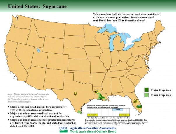


 Today we start learning about land owners inside the Everglades Agricultural Area (EAA) as listed on the above map; some will own land within Joe Negron’s proposed circles for land acquisition, and some will not. In any case, we should know them all.