I am posting this, not because I want to but because I have to. I much rather be enjoying the day instead of once again sitting at my computer. But time is of the essence.
This morning I read a comment by TcPalm reporter, Ed Killer, on Facebook stating the ACOE’s pulse release schedule for the St Lucie River.
If this is true, and with Ed Killer posting, I believe it is, the ACOE will start releasing again Monday, 6-25-18. I did not know this until I read his post.
Today, my husband Ed and I were flying other people over Florida as usual, and during our flight I took this video expecting maybe some algae in C-44 but instead also found the gigantic bloom against the gates of S-308 in Lake Okeechobee leading into C-44/SLR.
So I wrote on Facebook:
I am so over this, but cannot fail to report. According to Ed Killer ACOE will start discharging from Lake O tomorrow in spite of Governor’s Emergency Order. Look at this algae mess waiting at gates of Port Mayaca. Write ACOE’s LTC Jennifer Reynolds and politely ask for ACOE to wait and to have DEP test again: jennifer.a.reynolds@usace.army.mil (JTL-S-308 video taken 6-24-15 at 12pm) #toxic2018
As Monday is tomorrow, and I fly to DC with the River Kidz tomorrow, I am posting this now. I truly believe considering the circumstances, that the ACOE should refrain from discharging at S-308 or S-80. And the state’s FDEP (Florida Department of Environmental Protection) should have this water tested, again, as bloom has changed.
To just dump this on the people of Martin County along the St Lucie River is a crime.
Respectfully,
Jacqui
PLEASE WATCH THE VIDEO
The recognizable shape of S-308 the entrance to C-44 and the SLR. Lake O’s connection to the river—obvious massive algae bloom at gates.Bloom as satellites show is throughout and scattered in lake. This shot is looking more towards middle of lake in southern area.
Entrance to Caloosahatchee on west side of lake and near Clewiston Bloom is all through lake.
Present Lake O algae bloom, as first publicly reported June 2nd, has grown to approximately 253 square miles. Although larger, this bloom appears less dense from space than either the June 24th or July 2nd 2016 images – that measured approximately 239 square miles. Image courtesy of Todd Thurlow, 6-20-18. See other satellite images here: http://www.thurlowpa.com/LakeOImagery/
The algae in Lake Okeechobee is Mother Nature’s political checkmate, the time in chess in which the King cannot escape…
Thank you to Department of Environmental Protection Secretary, Noah Valenstein, whose Emergency Order directed by Governor Rick Scott, announced yesterday, will implement an array of new actions to move more clean water south into the conservation areas and away from the estuaries.
Sending algae that is potentially toxic to the communities of the St Lucie River and the Caloosahatchee is political suicide even for the Army Corp, an entity that is basically untouchable, like a King.
But since the state is legally in charge of water quality, not the Corp, the order comes from Florida’s Executive Branch as they, became aware of the seriousness of the problem. The Corp has reported they were lessening discharge amount anyway, however, they did not recognize the health threat of the algae…
Nobody wants to purposefully poison the estuaries, but the Federal Government and the State of Florida does when algae, potentially toxic, is sent through gates connected to Lake Okeechobee. We are all in a difficult situation, a chess game whose rules are outdated and were created years ago…
And even if there is “limited capacity” to move water south, it can be done. “Something” is “everything” in this water game of chess. We must take what we can get, check the King, and then go back for more – the goal to close the gates forever. “Checkmate.”
In my opinion, this emergency order is a real move that will send more water south and help reinforce a “send water south,” political culture that all Florida must embrace!
God Save the Queen, our one and only, “Mother-Nature.”
(I have updated this post due to spelling errors, etc.. 6-24-18. Sorry. I, like everyone, am exhausted. JTL)
Taken this morning, 6-19-18, at St Lucie Locks and Dam, Mr. Greg Langowski, Regional Director for U.S. Senator Marco Rubio, has perfectly documented by video what is happening….
~The algae from Lake Okeechobee, and whatever else is now in the C-44 canal since the ACOE started discharging from Lake Okeechobee on June 1st, is clearly, – like an endless line of green ooze – getting sucked into the backside gates at St Lucie Locks and Dam, only to be spit in aerated form out the other side into the St Lucie River – where it will later re-congeal possibly into toxic gatherings.
Talk about throwing your trash over the fence….
Thank you Greg for this video, and hopefully the ACOE, The Florida Department of Environmental Protection, the SFWMD, and the Department of Water Quality and Best Management Practices of the Department of Agriculture will see and then visit themselves.
Things are happening almost in real-time today. My brother, Todd, sent me the L7 and Sentinel satellite images from yesterday revealing an approximate 102 square mile bloom in Lake Okeechobee.
I, in turn, wrote a blog post and sent the image to my husband, Ed Lippisch, who had flown across to west coast of Florida this morning.
Not too long after sending Ed that image, I look at my phone and it says “shared” photos from Ed, so I start looking at them. They are of the bloom in L.O. – over the broad area where the satellites had detected algae.
The phone rings, it’s Ed, he says” I just landed in Stuart.” I reply, “Great photos. Horrible. Thanks.”
He says: “Jacqui it was unbelievable. Very large bloom, it ran above Port Mayaca to about the southern shore of the lake and westerly. Very much like the satellite image you sent me, but even further north…”
So here are Ed’s unedited photos taken and then sent to me at 1:14pm, 6-16-18. Today.
I could never do what I do without the people who help me. My husband, his pilot friends, the everyday people sending me “toxic-algae” imagery, the River Warriors community, and when it comes to striking the bull’s-eye, my science-studied-lawyer, little brother, Todd.
Just hours ago, Todd forwarded these images from satellites, Landsat 7, and Sentinel 2, clearly showing a large algae bloom photographed yesterday in Lake Okeechobee. 102 square-miles of it!
So Florida state agencies, and others…
…Do not tell me the algae comes from our river. It does not. We have been through this before….
The algae, that can become toxic, and maybe already is, starts in, and comes from the crock-pot of Lake Okeechobee. The Army Corp of Engineers should stop discharging right now. Right when the Colonel sees these images. And these images have been seen, because NASA makes these images available to the Corp.
When a satellite image like this is made public, it cannot be ignored.
The ACOE should close the gates of S-308 until DEP has tested all edges of this large bloom. And work for never discharging when there is an algae bloom in Lake Okeechobee.
Stop the discharges from Lake Okeechobee!
LE07_L1TP_015041_20180614_20180614_01_RT-cropSentinel-2 L1C from 2018-06-15Sentinel-2 L1C SWIR from 2018-06-15Sentinel-2 L1C NDVI from 2018-06-15Sentinel-2 L1C SWIR crop from 2018-Sentinel-2 L1C NDVI crop from 2018-06-15
St Lucie River looking across from Central Marine to Martin Health.
Mary Radabaugh called me this morning.
“Jacqui, get dressed and come on over here to Central Marine! It’s happening again, and this time there are logs, algae logs. I have never seen this before.”
since May 23rd, Mary and I had been exchanging photos of the water in the St Lucie River at the marina she and her husband have managed for many years. The marina that brought national toxic algae coverage in 2016. The marina that the SFWMD and DEP did core samples of river bottom in 2005, but have been quiet since. The marina that is the ground zero of zeros…
So I got dressed and headed over.
The waters have slowly been changing, worsening since the C-44 basin waters opened into the river about March 15th. And Mary has documented this change on her Facebook page. After June 1st, when the ACOE opened S308 to discharges of Lake Okeechobee, things have sped-up and are starting to crescendo.
Only three days ago the waters of the St Lucie River were primarily a dark cloudy coffee brown sometimes with little specs. Then as winds and tides push the specks and foam in the river into the pocket of the marina, the now green specks of particulate start to organize. It is incredible to see that just from yesterday, to today, the algae has bloomed in bright fluorescent green slicks. In 2016, this happened all over the river, primarily in marinas, coves, along shorelines, against dock pilings and any other place the forever thickening algae would get “hung up.”
It is happening now too, but not as extreme. Yet.
This all happens because over the past 100 years the St Lucie River’s basin has been expanded tremendously, erroneously, taking on developed-land’s, and agricultural canal water (C-44, C-23, C-24) that pollutes and turns the brackish estuary fresh. Once the canals have almost killed the river, then the ACOE opens the gates of Lake Okeechobee without even checking the water quality from the SFWMD, or better yet, the Department of Environmental Protection (DEP). Just let ‘er roar!
This time, as was the case in 2016, an algae bloom in the lake is being transferred into the river through C-44. This is totally obvious with arial photography. The blooms start in the lake.
But since the river is now fresh, from all the canal water, the microcystis algae coming and once living in Lake O can live here too, and bloom toxic…
That the federal and state governments do this to their own people is mind-boggling. I know there are many water bodies around the county with algae issues, but we are certainly the only place in America where the government is knowingly dumping it on to a community of people.
There have been many opportunities over the years to fix the situation, but no, pure crises of the past few years is necessary before considering a fix….yes and thank God the EAA Reservoir is on the horizon. We must hold fast!
Today, I am sharing the photos of the Central Marina algae and its blooming.
Tomorrow we shall see what else it brings….this algae has not been tested yet, but one thing is for sure, if history repeats itself, it surely will be toxic.
In closing, be sure too to watch the poor manatee eating the algae off the seawall. Having survived millions of years as a species, he or she certainly deserves better.
TIMELINE TWO DAYS
Tuesday, June 12, 2018 7:58 AM
By afternoon it was swirling into designs.
Tuesday, June 12, 2018 2:59PM
And then by today, it was filling in those shapes with fluorescent green.
I, as many, have seen and received multiple algae reports via Facebook, text, and through the tremendous reporting of Tyler Treadway of the Stuart News. Now, I am encouraging everyone to take the time, and it doesn’t take much, to report their algae sightings in the St Lucie River/Indian River Lagoon to the Florida Department of Environmental Protection, (DEP).
It was Mike Connor who reminded me to do this, after my husband Ed accidentally spotted the algae lines by plane off Port Mayaca ~in Lake Okeechobee~ on June 2nd, the day after the ACOE started discharging.
At first I thought, “I’m too busy for that…” and then I realized of course I need to report to DEP because then the state is obligated to document and to test it for toxcidity.
Better yet, if everyone who is reporting via social media and text called DEP, there would be so many test sites for DEP to test, it would exhaust their resources.
Oh well…
Since our resources are gone, this is only fair.
As they say: “All is fair in love in war.”
Please report algae sightings; see link below.
If you can’t figure it out this unclear website, call the Governor’s office: 850-488-7146 or Noah Valenstein the head of DEP: 850-245-2118.
When the St Lucie River/Indian River Lagoon start to deteriorate due to discharges, things start going downhill fast. And when my husband Ed and I start taking and sharing aerial photos, my world becomes a bit chaotic.
Sometimes there are days of hundreds of photos to look through, and knowing the importance of getting them out immediately, choices have to be made. Facebook is a better medium than my blog for real-time info as it takes less time, but my blog is better for historic documentation as it is “permanent.”
So today I am sharing more of Ed’s photos from 6-5-18, and some you may have already seen. Mind you, after heavy rains, stormwater has been pouring in from many canals but, always, like clockwork, after the ACOE starts discharging from Lake Okeechobee, the river looks not just cloudy-coffee brown, but contaminated.
The ACOE started discharging from Lake Okeechobee on 6-1-18, and as most of you know, now, there are not only algae blooms spotted in the lake, as Ed accidentally found on 6-2-18, and others also documented, but also in the St Lucie River. More than likely, there will be more and more algae bloom popping up as the Lake O water makes its way down the estuary, over the tip of Sewall’s Point, towards the St Lucie Inlet. Algae floating down the river is disgusting enough, but toxicity is the real question…
Ed and I will take and share more aerials in the future, to document the algae blooms should they explode, but until then, here are some photographs from 6-5-18 that I had not yet archived on my blog. Sadly enough, although there is no algae in these pictures, I cannot say they will make you feel any better.
Never take the pressure off politicians to build the EAA Reservoir and get it to where it needs to be to clean and filter this water to send south as Nature intended. Government knowingly contaminating its citizens is not an option. Health, Safety and Welfare is a responsibility.
Photos taken 6-5-18 showing SLR/ILR near Sewall’s Point; Jupiter Narrows; Atlantic Ocean/beach over nearshore reefs along Jupiter Island just south of St Lucie Inlet; out in ocean near Peck’s Lake; Sailfish Point/Sailfish Flats area; and Bird Island, a Critical Wildlife Area, for many threatened and endangered birds.
SLR on west /IRL on east – looking towards Sewall’s PointJupiter Narrows near St Lucie InletA Coffee Ocean along Jupiter Island just south of St Lucie InletDischarges in waves looking east to Peck’s LakeDischarges going over near shore “protected” reefsDischarge plumePlume out about 2 miles in Atlantic/documented at 5 over days by fisher peopleSimilar photos give felling of flying overReefs with plume coming onSelfish Point and Sailfish Flats area one the “most biologically diverse in North America.” Seagrass is gone due to receptive discharges episodesCircling home- close up souther tip of Sewall’s PointAgain circling ove Sailfish Flats on way back to Witham Field.Bird Island just off of southeast Sewall’s Point is home to hundreds/thousands of birds. Many threatened and endangered species raise their young on this island that was designated a CWA or Critical Wildlife Area by FWC in 2014. At the time it was the first to be designated in 20 years.
Since my husband, Ed, accidentally spotted an algae bloom in Lake Okeechobee, while running new engines on the Baron, I have posted many photos on Facebook and the word is out.
Nonetheless, for purposes of documentation, I am going to post some of the photos again on my blog for historical purposes and for those who do not use Facebook.
~Ed noticed the “lines of algae” in the lake on June 2, two miles or so northwest of Port Mayaca, the day after the ACOE started discharging from Lake O into the St Lucie River. Absolute chance, fate, or a tip from above, however you decide to look at it.
Since this time others have documented on the ground and DEP should be testing for toxicity.
So, after seeing the bloom on Friday, Ed went back the following day on Saturday in windy conditions so I stayed home–in the yellow plane, the Cub, getting more pictures of bloom, looking about the same but more dispersed from rain perhaps. These photos at lower altitude also include drainage structures around the lake, as well as the destruction of the St Lucie River/Indian River Lagoon at Sewall’s Point and the St Lucie Inlet.
Photos will continue to be taken as we once again, document the discharges, and once again have seen first-hand, like we did in 2016, without the warning of our government, that the algae that contaminates the St Lucie River starts in Lake Okeechobee.
I woke up to seeing sunshine through the window. I looked at my phone. My brother’s text read: “S-308 just jumped to 1484 cfs and its climbing.”
(Go to St Lucie River for reports: http://www.thurlowpa.com/news.htm)
In Sewall’s Point, today is the first morning in three weeks that it hasn’t been raining, or just about to. My porches have been slick with moisture and leaves. The frogs in my pond are so loud at night I have to put in ear-plugs. My husband and I laugh saying you can count sheep, but there is no sleep!
In spite of all of this and the fact that the ACOE has been discharging from C-44 canal basin since around May 16, and the St Lucie River already looks like hell, it is still disappointing and heart-wrenching when they formally “open the gates.” ~To Lake Okeechobee that is…
In spite of the history, or knowing why they do it, it just seems so wrong that little St Lucie has to take basically one-third of the crap water for the state. Sorry and I know my mother will not like that word, but its the truth. Thank God for Joe Negron and his work last year as President of the Florida Senate and resurrecting the EAA Reservoir. And curse to any new Governor who does not help it be fulfilled.
The natural drainage basin of the St Lucie River shown in GREEN below was much smaller than it is today. The introduction of four man-made drainage canals dramatically altered its size and the drainage patterns. This primarily being C-44, the canal connected to Lake Okeechobee (bottom). One can see from the map image that C-44 Basin and of course Lake O’s water, the most effective assassins, were never part of the St Lucie Basin as were not Port St Lucie’s C-23, C-24, and C-25 system. These canals have killed our river!
The EAA Reservoir must be built, and in time, more water must move south to Florida Bay. We shall be fixed or compensated or a combination of both for our now noxious-reality. We will not accept this fate. Who knows what this summer shall bring. But one thing is for sure, this life along the St Lucie, is now toxic.
Drainage changes to the SLR. Green is the original watershed. Yellow and pink have been added since ca.1920. (St Lucie River Initiative’s Report to Congress 1994.)
A lone Great Egret looks for fish along a putrid looking, foam filled river. All images taken yesterday, 5-31-18 at Ernest Lyons Bridge. JTL
Thank you to ACOE for the following information and press conference yesterday.
Lake O water management slide_20180531: this slide shows lake levels comparatively. The lake is now high going into hurricane season, starting June 1st, ironically today. The lake is managed as a reservoir for agriculture.
Email 5-31-18
All,
The U.S. Army Corps of Engineers (USACE) Jacksonville District will start releasing water from Lake Okeechobee this weekend as part of its effort to manage rising water levels.
The discharges are scheduled to begin Friday (June 1). The target flow for the Caloosahatchee Estuary is 4,000 cubic feet per second (cfs) as measured at Moore Haven Lock (S-77) located in the southwest part of the lake. The target flow for the St. Lucie Estuary is 1,800 cfs as measured at St. Lucie Lock (S-80) near Stuart. Additional runoff from rain in the St. Lucie basins could occasionally result in flows that exceeds the target.
“Historic rain across the region since the middle of May has caused the lake to rise more than a foot,” said Col. Jason Kirk, Jacksonville District commander. “We have to be prepared for additional water that could result from a tropical system. The lake today is above the stage when Irma struck in September, which eventually caused the water level to exceed 17 feet. A similar storm could take the lake to higher levels.”
Today, the lake stage is 14.08 feet, up 1.25 feet from its 2018 low which occurred May 13. The lake is currently in the Operational Low Sub-Band as defined by the 2008 Lake Okeechobee Regulation Schedule (LORS), but within one foot of the Intermediate Sub-Band. Under current conditions, LORS authorizes USACE to discharge up to 4,000 cfs to the Caloosahatchee (measured at S-77) and up to 1,800 cfs to the St. Lucie (measured at S-80).
“Forecasts indicate more rain is on the way in the coming week,” said Kirk. “Additionally, long-range predictions indicate increasing probabilities of above-average precipitation for the rest of the wet season. We must start aggressively managing the water level to create storage for additional rain in the coming wet season.”
Images from: The Boyer Survey: An Archaeological Investigation of Lake Okeechobee, 2011 by Christopher Davenport and others, PBC.
To archeologists Pelican Lake is regarded to have been the headwaters of what was once Pelican Bay and the Pelican River east of Lake Okeechobee. One of the first to write about this lake was Lawrence E. Will whose family was the first to grow sugarcane in the sawgrass areas rather than the custard apple region south of the lake. Will was an amazing documenter and the Museum of Glades in Belle Glade is named for him today. Although the Will’s have been remembered through the museum the remains of Pelican Lake, Pelican Bay, and the Pelican River are all but forgotten.
For purposes of time, we will first focus on Pelican Lake.
According to the Boyer Survey, other than Will, very few facts were written about Pelican Lake ~named so, obviously, for being the home once to many pelicans. Today, by working backwards, archeologist are finding out more facts, through the study of historic photographs, aerial vegetation and soil patterns, and the use of Google Earth. With these tools, similar to what my brother uses in his Time Capsule Flights (https://jacquithurlowlippisch.com/todd-thurlows-time-capsule-flights/) the ancient river beds are being revealed. Archeologists study such to find the villages of ancient people who lived along these lakes and these so-called “dead rivers,” that were anything but dead. The data revealed about the dead lakes and rivers, “refutes the South Florida Water Management District’s findings suggesting these rivers were “very short.” (Solar et. al 2001:2-19). They were not short; some were miles long! In the case of the Pelican River, it has revealed itself to be 16.3 miles long, its waters beginning in Pelican Lake. (Boyer Survey p. 246)
So poor Pelican Lake. If you view the images from the Boyer Survey below you can see how in the early 1900s the lake was drained for development as reclaimed land.
The Boyer Survey: An Archaeological Investigation of Lake Okeechobee, 2011The Boyer Survey: An Archaeological Investigation of Lake Okeechobee, 2011The Boyer Survey: An Archaeological Investigation of Lake Okeechobee, 2011Google Earth 2018. Larrimore Road is the middle of what once was Pelican Lake in Pahokee.Ancient river beds, lake and bay revealed: The Boyer Survey: An Archaeological Investigation of Lake Okeechobee, 2011
In 1918 famed Botanist John Kunkle Small wrote that Pelican Lake was “the most beautiful lake during the day or night” and was disheartened upon returning to the area seeing that the beautiful lake had been drained and reduced to either “weeds or agricultural fields.” SEE HIS INCREDIBLE PHOTOS HERE:
The Boyer Survey notes that Pelican Lake is just one example of how much and how fast the area around Lake Okeechobee changed as drainage effort progressed. The last major changes occurred when the Herbert Hoover Dike was completed in the 1930s and vast expanses of lakebed were “permanently” made into sugarcane fields.
This is why the lake is smaller by about 30% today and cannot hold as much water. A lot of that water is discharged today destroying the St Lucie and Calloosahatchee Rivers. It is important for us to know our history so we can fix the mess we are in today. There were no dead rivers or lakes. The only dead ones are the ones we killed. The southern edge of Lake Okeechobee was flowing with rivers and life. Life, that we have conveniently forgotten.
Florida Memory, early Everglades drawing, Anonymous.
We have really killed them. A Google Search will bring up practically nothing, although they were probably the most interesting Everglades’ feature of all. Lake Okeechobee’s “Dead Rivers,” entitled as such as they were “perceived not to go anywhere…” but they did…they flowed out of Lake Okeechobee, running through the custard apple forest, and then disappeared into the sawgrass river of grass, today known as the Everglades.
The engineer of Hamilton Disston stated that there were 17 rivers leading out of Lake Okeechobee. Some of the larger ones were named the Dead, Democrat, Dowell, Forked, Hidden, Copper, Hutchinson, Leatherman, Menge, Pelican, and Ritta. Some were miles long, over 100 feet wide, and many feet deep. These rivers flowed curvaceously through the custard apple/pond apple swamp that extended from the lake’s rim as far as four miles south. Today these locations encompass the cities south of the lake especially Pahokee, Belle Glade, South Bay, and Clewiston.
Presently, the south and eastern shores of Lake Okeechobee are devoid of these once very rich-with-life rivers as they have been cut-off, redirected into canals, filled in, or diked. Apparently it was documented that the “dead” rivers could flow north or south depending on rainfall. We found it more efficient to drain the Lake and to eventually erect a dike destroying all of the wildlife highways.
The Boyer Survey: An Archaeological Investigation of Lake Okeechobee, 2011, by Christopher Davenport and others–from which these images and much of the information in this post comes from, show where some of these ancient and now “dead” rivers flowed. One thing is for sure, they were never really dead, until we killed them. I think it is important to, at least for our memories, bring them back to life; we will learn more about them.
IFAS: http://conference.ifas.ufl.edu/geer2008/Presentation_PDFs/Thursday/Royal%20Palm%20VIII/1040%20C%20McVoy.pdf SFWMD notes dead rivers “as a mile or less.”The Boyer Survey: An Archaeological Investigation of Lake Okeechobee, 2011The Boyer Survey: An Archaeological Investigation of Lake Okeechobee, 2011The Boyer Survey: An Archaeological Investigation of Lake Okeechobee, 2011The Boyer Survey: An Archaeological Investigation of Lake Okeechobee, 2011The Boyer Survey: An Archaeological Investigation of Lake Okeechobee, 2011Google Earth 2018.
My grandfather, J.R. Henderson, was a well-known soil-scientist back in the 1930s for the University of Florida.
I remember him telling me things about cows, plants, and the lands under them when we were driving on the “Sunshine State Parkway,” from Gainesville to Stuart. I think of my grandfather more these days and believe the study of geology and soils are in my blood although I know almost nothing about them.
So to educate ourselves and the those young people of the future we continue our study of the Boyer Survey of Lake Okeechobee, by Christopher Davenport and others–and today we will look at the section entitled Region Geology.
The Lake Flirt Formation is noted to consist of three thin limestone layers the uppermost being caprock. This is often used by landscape companies to beautify our yards. I don’t understand how it is mined without jeopardizing the aquifer, but that’s another blog…
On top of the capstone and limestone layers are sands from the Pamlico Formation. These sands were blown across the state from east to west forming dunes over thousands of years. There is also clay that “resulted from deposit under Holocene ponds and marshlands.”
Source: Florida’s Fossils: Guide to Location, Identification, and Enjoyment By Robin C. Brown
That’s just a quick review. But might get you interested again.
It is extremely humbling to refresh one’s memory on all this stuff we learned in grade school, as we are living in “the top layer” of millenniums. We in time, will just be another layer of an ancient coral formation we live upon, Florida. Nonetheless, it is important to know what is around us, above us, and under us. 🙂
From my grandfather’s book: Florida Geological Survey 18th Annual Report, 1927. The map show the various shorelines of Florida as sea levels have risen and fallen.
Satellite map of South Florida, public image ca 2005.The mole knows what under – he lives there! 🙂
Water skiing in the St Lucie River/Indian River Lagoon at Michele White’s house with great friend Kevin Wilkinson, 1980.The Boyer Survey: An Archaeological Investigation of Lake Okeechobee, 2011, Christopher Davenport and othersSFWMD before and after satellite image effect
As I got to “Physiographic Regions,” when reading the Boyer Archaeological Survey, I had to look up the definition of physiographic. My mind kept wandering to Physical Graffiti, the title of an album by Led Zeppelin, and the fun days of Martin County High School skiing the in St Lucie River/Indian River Lagoon with my best friends.
In retrospect, Lake Okeechobee and the St Lucie River were already dying by the time I was in high school. Today, I wish I had learned more about our ailing ecosystem when I was younger, and not finally caught on when I was 40 over ten years ago. “Catching-on,” this is my hope for the next generation as there are serious impacts we won’t be able to ignore, happening, and on the way. Knowing what “physiographic regions” means will help us understand what we can do.
Physiographic is defined simply as “the branch of geography dealing with natural features and processes.” So the Figure 5. map above shows what the surrounding ecological communities were before they became developed as today’s counties. These areas are labeled as the Eastern Flatlands; the Everglades; the Western Flatlands; Big Cypress Swamp; and the Mangrove and Coastal Marsh.
As we know the Everglades is one of the largest freshwater marshes in the North America and the world. It starts trickling up in the Kissimmee River Basin above Lake Okeechobee. Unfortunately, this area of the map is always cut off so we think in terms of south.
Basin Management Action Plans,. The Kissimmee River is north of Lake O. Florida. TCRPC doc. 2015.
The open marshes of Lake Okeechobee extended from the southern rim of Lake O and the Loxahatchee Slough south to the mouth of the Shark River Slough at Florida Bay and the former Miami River. Florida Bay is presently, and has been, experiencing extensive algae blooms due to lack of fresh water and the once beautiful Miami River, attached by canal (since 1911) to Lake O? “Dead.”
The Boyer Survey image once again for comparison.Map of Canals 1924 Florida Archives.
The eastern and western flatlands to the east and west of Lake Okeechobee (Stuart/Ft Meyers ) were similar in vegetation types and animals. The Boyer Survey notes “both can be described as mosaic landscapes consisting of wet prairie, palmetto and dry prairies, pine forest or flatwoods, cypress forests, mixed swamp forests as well as ponds and sloughs; these areas were low, sandy, and poorly drained.” The Loxahatchee River drained the eastern flatlands into the Atlantic, and the Caloosahatchee River drained the western flatlands into the Gulf of Mexico. Today these waters flow by way of the ACOE/SFWMD Central & Southern Florida project’s water control structures slowly making everything as “dead” as the Miami River.
Until we treat waterway funding like roads, (FDOT:http://www.fdot.gov/transit/functionsgrantsadministration.shtm) Mother Nature’s water highways will become even more of a backed-up, misdirected, putrid mess. We must stop trying to direct her like a God, and let more of her natural features return. After all, Nature is a House of the Holy and we never know when the Rain Song will begin…
With my niece Evie Flaugh at Women of Distinction 2018. Evie was recognized for co-founding River Kidz seven years ago.
I hope everyone had a happy Mother’s Day yesterday! One of our “around the table” family discussions went like this:
Jacqui:” I’m getting a new headshot this week because now my hair is gray.”
Sister Jenny: “Why? Are you running for office?”
Jacqui:” No, not now. But I want my blog photo to look like me.”
Sister Jenny: “Why!” 🙂
Whether it’s my hair, or our natural landscape, things are always changing! I think it’s important to let young people, like my niece Evie, Jenny’s daughter, almost 18 and entering the world, know what our natural landscape looked like “before,” as they will be dealing with water issues we can’t even imagine.
One of the least documented changes of Florida is the demolition of the pond apple belt of Lake Okeechobee. I hope in time, the younger generation finds a way to recreate its original natural purpose that was to strain, slow down, and clean the lake water flowing south into the sawgrass plains of the Everglades. Another benefit was flood protection. Nature’s adapted protections out-do mankind’s every time…
Full image, Lake O pond apple belt. The Boyer Survey: An Archaeological Investigation of Lake Okeechobee, 2011.The pond apple belt today is gone, replaced by the cities/areas of Port Mayaca, South Bay, Belle Glade, Pahokee, and Clewiston. The pond apples were torn out to access the value muck soil beneath them. Google Earth image.
In pre-drainage times, the original features of Lake Okeechobee helped contain it. There was the Okeechobee Sand Ridge; the Southern Ridge; the Spillover Lands; and the fossilized coral ridge.
The Sand Ridge extended from Martin County to Palm Beach County ~just north of Pahokee. There was a cut in this ridge where water could more easily escape east at today’s historic village of Sand Cut along the eastern shoreline. Archaeologists believe this Sand Ridge running along the lake was an old shoreline. It is stated in the research of the Boyer Survey, An Archaeological Investigation of Lake Okeechobee, by Christian Davenport, Gregory Mount and George Boyer Jr., that only the eastern shore of Lake Okeechobee was “defined by a sand shore.” Today the Army Corp has built a dike along and over this sand shore with the addition of extra boulders for protection. Very unattractive. The original pond apple forest would not just have been more lovely, but would have helped in times of storms ~ similar to how mangroves, even in front of a seawall, do today.
The Southern Ridge was a high muck ridge that had formed at the southern end of the lake and was located in a “massive belt of pond apple trees.” This forest was completely mowed-down to access the deep muck for agricultural purposes. It was 32,000 acres! (Lawrence E. Will) The towns of *Port Mayaca, Pahokee, Belle Glade, South Bay, and Clewiston south today’s Lake Okeechobee are located in what was once the pond apple forest. Surreal, isn’t it?
These trees grow closely together and can get very large. They have weird roots kind of like mangroves. My husband Ed and I bought a lot along Overlook Drive in Stuart and oddly or interestingly enough in this area there are pond apple trees. According to the study, the original lands of Lake Okeechobee sloped towards the lake, meaning the lake would have been as much as two miles wider during periods of high water. (The forest and the shape of the land held the water in the lake.) Along the southern edge “dead rivers” cut through this muck ridge and were the primary outlet during times of high waters. (Boyer Survey)
Pond appleGiant pond apple trunk, near Overlook Drive in Stuart, FL.2017.JTLFlorida Memory photo, pond apples belt at rim of dead river/creek. John Kunzel Small 1869-1938.
Spillover Lands was the archeological term for the lower-sawgrass plains extending beyond the southern side of the pond apple forest. Here sheet flow was created that moved and melded into the Everglades, basically a littoral marsh.
By the way the “dead rivers” were anything but dead, some very deep and very long. The word “dead” was applied as some of the original explores could not find “the end,” and I believe this word suits today’s powers well as the word “dead” makes one think they had no life. The complete opposite is the truth. They were full of life! All the animals of the Everglades, including hundreds of birds colonies lived in these areas that were completely DESTROYED.
The final formation mentioned in the Boyer Survey is an ancient Fossilized Coral Ridge (Reef) that runs from approximately Okeelanta to Immokalee. In pre-drainage times, this muck covered reef caused a higher elevation that is thought to have helped retain some of the water within the Spillover Lands during times of low water. Hmmm? Another Nature feature that works better than our manmade ideas for drought protection today – deep well injection, and other brilliant ideas….
Well, I hope you enjoyed today’s lesson! And I hope some young people like my niece Evie in the photo at the beginning of this blog read this post some day. Gray hair can be dyed or glorified, but the natural features of Lake Okeechobee in the heart of Florida, they must be rebuilt as part of today’s modern eco-system.
River Kidz workbook 2, “mythical pond apple forest,” Julia Kelly, 2014.
I recently took trip with my husband; I accompanied him on business to Santa Fe, New Mexico. While I was there, I visited the Museum of Indian Arts and Culture. The museum focused on the remarkable Pueblo people that had originally settled along the Santa Fe River because of its water and transportation. The museum was gifted telling stories, and it got me thinking about the native people who lived around Lake Okeechobee, and how their story is not so well told.
Belle Glade Culture, People of the Water, possibly (450BC-1600AD) Courtesy Florida Museum of Natural History.Belle Glades Culture area around Lake O and Kissimmee, source: The Boyer Survey.
(Adapted from, The Boyer Survey: An Archaeological Investigation of Lake Okeechobee, 2011)
In the fall of 2006, the South Florida Water Management District lowered Lake Okeechobee as a hurricane was expected, but it not come. Much to the District’s dismay, severe drought came instead. As the water in Lake Okeechobee evaporated, its depth went from a normal (at the time) of 18-20 feet to a recorded low of 8.8 feet. Although this was a negative for the ecosystem, it allowed human remains and artifacts of what is referred to as the “Belle Glade Culture” to be exposed. Artifacts and bones began to comprehensively reveal their stories of *pre-Columbian (*before the arrival of Columbus to the New World) times. These native americans over a period of 2,700 years built extensive earthworks and canals, adapting the surrounding wetlands to be suitable for their people to live. The Lake, of course at that time, more than supported their hunter-gatherer-fisher lifestyle and complex culture. The Belle Glade Culture was part of a greater exchange network and traded with other groups from distant locations.
These Native Americans living around Lake Okeechobee were the descendants of people who migrated to the peninsula approximately 12,000 years before. Out of that small group of prehistoric nomads developed an array of cultures that spread across Florida that eventually contained hundreds of thousands of inhabitants. Like Santa Fe’s Pueblo, they were a remarkable culture. However, unlike the Indian cultures of the west, many of the Florida native people, and especially the Belle Glade people, are not well-known.
These ancient people of the water are the muffled voice of Lake Okeechobee ~just as the voice of the lake itself that is now dammed, diked and controlled. May the Belle Glade people, and the heart spirit of Lake O be revealed…
Although we do not know what these people looked like a visit to the Lawrence E. Will Museum of Glades (https://www.museumoftheglades.org) by appointment is a great place to start. Also artist Theodore Morris, has spent his life trying to recreate these related people:
When in Washington D.C. last week, the Everglades Foundation and various groups met with both Republicans and Democrats, with new members of Congress and “old.” During the visits I asked what was the best way for the people of Florida to influence members of Congress to “vote for the EAA Reservoir.”
The answer? A handwritten note. ~And yes, it takes two weeks to be thoughtfully and carefully processed for safety reasons, making it even more “valuable.”
I have written about hand-written influencing before: Advocacy has many faces, but none perhaps more powerful than a handwritten note or letter. Why? Because it takes effort; because it is thoughtful; and because it is old-fashioned, rare, and special. My mother taught me this… In a world where furious Tweets and Facebook posts, or better yet, Snapchat allows one to “live in the moment and then erase it,” we are surrounded by communication that holds impermanence. The hand written note leaves a lasting impression… especially in the “rough and tumble,” yet traditionally based world of politics.
Mind you, your note or letter need not be long; it must just be sincere…
Politicians often get thousands of emails and if they are a “canned” this can almost become a nuisance. But when the hand written note comes in, the politician takes notice.
Below are the committees that hold the fate of the EAA Reservoir in their hands. Please consider writing a note, postcard, or letter. Look through the lists of members, who do you know? If none chose one to write to anyway. Your letter need not be technical, just sincere with the spirit of asking for Congress to “Save Our Northern Estuaries, Our Everglades.” 🙂
Fifty years have passed since my parents took this picture. The family was visiting the zoo and my mother told me to stand on the back of the giant tortoise for a photograph. I was four years old, and I refused. I “didn’t want to hurt the turtle” by standing on its back. My mother held the power in the negotiations. She won and I lost. I stood on the poor tortoise, but made sure my mother and father knew that I was mad about it. I gave it my best frown as there was no way I could hide my dismay ~as I wished to befriend and pet the turtle, not to stand on it.
The 1968 photo has become a family classic.
Over the years, I have learned that it is often the case, when dealing with the environment, that people with more power than I, tell me what to do. I often end up “standing on the turtle,” but today I smile. I have learned to conform, and I have definitely accepted that being mad, or mean, will get me few friends and even fewer successes.
This week, when I was in Washington DC with the Everglades Foundation, I was assigned to a great lobbying team. Our job, along with others, was to convince key congressional members of two things: 1. Authorization of the EAA Reservoir through the Water Resources Development Act as a portion of the CERP, (Comprehensive Everglades Restoration Plan), the master plan to restore the Everglades, that is cost-shared 50/50 between the State of Florida and the Federal Government. 2. Increase the Federal Funding for CERP as the federal contribution needs to increase to at least $200 million to begin to meet its cost-share commitment.
The feedback we got from the lobbied members of Congress was positive; however, sometimes I felt like that little girl standing on the tortoise when members in power told me that even with the approvals, if they were approved, Everglades restoration and improving the state of the Northern Estuaries and Florida Bay will take many, many years. “After all the Army Corp of Engineers has a very specific process…”
I smiled, but deep down inside I was frowning.
The environment, like the giant tortoise, should be treated more respectfully. Slow is for turtles, not for crises.
My lobbying team, SMILING, Everglades Foundation Summit 2018, #Nowor NeverGlades, John Adornato, National Park System; JTL, Tori Liner, “Path of the Panther;”Mark Perry, Florida Oceanographic Society (http://www.evergladessummit.org)
Algae pouring in from Lake Okeechobee from Central Florida waters, 2016.Algae bloom in Lake Okeechobee is estimated to be 263 square miles as shown in this NOAA satellite image on 7-2-16 shared by FOS on 7-6-16, Todd Thurlow.Everglades Foundation handout 2018
My husband, Ed, took these photos of the Indian River Lagoon at the St Lucie Inlet on 2-28-18, just a few days ago. They are certainly beautiful enough to sell real estate…The turquoise water is so pretty one could easily overlook the sand desert below the surface waters.
Enjoy the blue water, but know that especially since 2013, our seagrass beds have been decimated by black sediment filled waters and toxic discharges from Lake Okeechobee. Seagrasses are the nursery for all sea life, especially the baby fish. These beds need time to reestablish if they ever will.
True beauty has something to offer, not just “surface water.” Keep your eye on the lake and fight against any coming releases this summer so we can get life back in our dear dead river.
When I was a kid, many of Stuart’s older restaurants had signs. Some locals may recall Jake’s on US1, or still today, Harry and the Natives in Hobe Sound. There are certainly others, nevertheless, there seem to be fewer restaurants with funny signs hanging on the walls than when I was a kid.
Thus it was awfully refreshing when Ed and I were at Lake Okeechobee this past Monday and I forced him to drive north, close to the rim, on the Old Conners’ Highway to J&S Fish Camp. He was hemming and hawing the whole way, thinking I didn’t know where I was going, but I did. When we finally got there, after driving about four miles north of Port Mayaca, we had a beer in the Tiki Bar, read the collection of signs, listened to an awesome old jukebox playing our favorite songs, and laughed so hard we felt like we were young again.
With all of the development in Florida right now, and 26,000,000 people expected to live here by 2030, places like this become even more wonderful.
That they are “one in a million” is just a sign of the times….
Campgrounds outnumber lodgings along Lake Okeechobee, drawing visitors outdoors. Wayne McSwain, who was raised in Belle Glade, remembers camping along the shoreline of Lake Okeechobee. “You camped along this canal, because there were a lot of trees here,” he said, pointing down from his perch atop the Herbert Hoover Dike, “and you came out here and swam every day, and water-skied… and you didn’t worry about the alligators at all.”
McSwain’s father ran the grocery store on the road to Torry Island, along the way to Slim’s Fish Camp. “It was (started by) the Corbins,” McSwain said. “A lot of people from out of town came over here for fishing.” To get to Slim’s, you cross one of the last remaining manually operated swing bridges in the United States. “I was 14 or 15 when Slim let me turn the rod to make the bridge pivot out of the way,” McSwain said. “It was fun for me, and I bet he got paid for it, too.”
Camping along Lake Okeechobee has changed since McSwain’s youth. With construction of the dike, a key protective barrier given the seasonal threat of water-intensive hurricanes, away went the views and the easy access. Still, the lake draws campers all year. They settle into fish camps, bring RVs for the winter to the campgrounds lining the eastern shore and hike into primitive campsites along the Florida Trail. The one campground with a view of the blue horizon was briefly known as Pahokee State Park. “The land still belongs to the state,” said McSwain, “but they’ve leased it out to campground operators for the past 30 years or so.” It’s now Lake Okeechobee Outpost KOA with a lakefront pool and restaurant.
At J&S Fish Camp, regulars crowd the bar at 10 a.m. “We know we’re the oldest fish camp around the lake,” said manager Ted Miller. “The cabins were built for the people who worked building the dike.” For the price of “a beer and a stay in a cabin,” the murals of alligators and lakeshore came from an artist’s brush, and the 1930s cabins took on tropical hues. Lake levels affect business dramatically. “When the locks are open,” said Miller, “we have fishermen come in for boiled peanuts and a beer and to have a look.”
I guess one could say the St Lucie River is getting a new year’s present in that yesterday was the last scheduled release from Lake Okeechobee by the Army Corp of Engineers. The entire situation has a similar theme to an abusive relationship where the beaten thanks their oppressor for finally halting…
Due to Temporary Flight Restrictions (TFR) because of the President’s visit to Palm Beach, it was not possible to fly south along Jupiter Island from Witham Field in Stuart, however, when the wind and runway changed my husband, Ed, was able to get a few aerials at the Crossroads of the St Lucie River and Indian River Lagoon around Sewall’s Point. No seagrass, but the water already looks better.
After being decimated in 2013; part of 2015; toxic in 2016; and experiencing a no-holds-barred discharge rate since September 20, 2017, post Irma; we will continue to fight for the EAA Reservoir’s success and a better 2018 for our St Lucie River.
We shall never, never, never, give up!
Please see links to my brother Todd Thurlow’s website for St Lucie Canal Real Time Flows S-80 Cumulative 2017 and Latest Lake O Satellite Imagery
12-4-17, ca. 2:45 pm, photos: Ed Lippisch & Jacqui Thurlow-Lippisch
The Army Corp of Engineers has lessened but not stopped Lake O discharges that started September 20th, 2017 just prior to Hurricane Irma. Perhaps as the discharges have gone on at such a high rate for a comparatively long time, the plume has had a chance to extend its territory. In yesterday’s photos, the dark, filthy plume is reaching clearly south beyond the exclusive Town of Jupiter Island.
Yesterday was a beautiful day, but the river and ocean waters of our entire region were ugly, possibly contaminated. How are we to enjoy our property and lives here?
When viewing the aerials below, please note the blue, sapphire-colored water just on the edge of the discharge plume. Yes, of course all estuaries put forth darkened fresh water after a rain event, and Ed and I could see this occurring just south at Jupiter Inlet. Nonetheless, the black, gigantic plume that we repeatedly endure for the St Lucie River/Indian River Lagoon due to discharges from Lake Okeechobee is an aberration.
Please let’s all support Joe Negron and the public’s work to build the EAA Reservoir; clean & send the water south!
Lake O discharges: http://w3.saj.usace.army.mil/h2o/reports.htmLooking south along the southern most area of Jupiter Island.Looking north along Jupiter Island-dark ocean waters. Jupiter Narrows an extension of the IRL on left.Plume -looking north along Atlantic coastEdge of plume; note clean sapphire colored water juxtaposed to dark Lake O/canal plumeAnother angle, Jupiter Island, looking south-blur due to wind and camera movementBack at St Lucie InletIRL, note bare bottom. This area is known as the Sailfish Flats and once had hundreds of acres of seagrass beds.The Sandbar, a popular weekend recreational area for boaters, especially families, surrounded in dark Lake O discharge waters. This is a health issue.Barren Sailfish FlatsSand bottom with no seagrass between Sewall’s Point and Sailfish Point. An area once teaming with life.The Crossroads — no seagrass beds just sand bottomIRL looking northSt Lucie River near St Lucie Inlet dark as coffeeNorth of St Lucie Inlet the plume covers near shore protected reefs as it does south of the inlet.Blue!The plume as viewed from under the wing of the CubPlume edge: The tainted water we are given by our government; the blue –the water we should have by God & Nature.
Last Thursday on November 16, the ACOE reported they will reduce the amount of water they are releasing from Lake Okeechobee. The Corp had been releasing at a high rate, on and off, since September 20th. New targets are 2800 cfs east and 6500 cfs west.
Photos below were taken yesterday, 11-19-17 by my husband, Ed Lippisch. We will continue to document the discharges from Lake O, and area canals.
As Thanksgiving approaches, we are thankful the discharges are lessened and that the SFWMD and the public are working hard to plan the EAA Reservoir Senator Negron fought for… We the people of Martin County, will not be satisfied until these discharge stop. The river has its hands full with unfiltered discharges draining agriculture and developed lands from C-23, C-24, C-25 and C-44. All must be addressed.
“And where the river goes, every living creature that swarms will live, and there will be very many fish. For this water goes there that the waters of the sea may become fresh; so everything will live where the river goes…” Ezekiel
St Lucie Inlet, Sailfish Point R, Jupiter Island L, and Sewall’s Point and mainland Stuart in distance.Sewall’s PointManatee PocketHell’ s Gate Sewall’s Point to rightC-23 main SLRConfluence of SLR/IRL at Sewall’s Point’s southern tipSewall’s PointIRL looking towards Sewall’s Point and Stuart. Incoming tide pushes plume waters north into IRLsomewhere looking down…
SFWMD canal and basin map. C-44 canal is the canal most southerly in the image and was connected to Lake O in 1923. C-23, C-24 and C-25 were built later in the 50s as part of the Central and South Florida Project that over-drianed South Florida causing many of the water problems we live with today.Atlantic ocean off Jupiter Island, plume water moving south over nearshore reefsIRL near Sailfish Flats where seagrass forests used to flourish housing many fish…Hutchinson Island looking to IRLRoosevelt Bridge SLRC-23 SLR
A lone sailboat is a sea of blackness, confluence of the St Lucie River/Indian River Lagoon, once considered the most biodiverse estuary in North America and full of seagrasses, a nursery for the ocean..http://w3.saj.usace.army.mil/h2o/plots/s308h.pdfI am very fortunate to have a small army of people helping me document the Lake Okeechobee discharges this year. Presently, it is the tremendous rate of government sponsored discharge from Lake O that is destroying the regions’ economy and ecology, right before our eyes, ~once again.
Friends of my husband, pilots Dave Stone and Scott Kuhns, took these aerials yesterday, 11-8-17 around 5 pm. When I asked Scott about the plume, he relayed that it went 15 miles south almost all the way to Jupiter Inlet, and since there is also rain driven, fresh, dark- stained water flowing out of the Jupiter Inlet (not over-nutrified, black-sediment water from Lake O) there was no clear delineation of blackened plume to aqua ocean water, like usual–rather, the waters are all dark….
“How far did the plume go east from the St Lucie Inlet?” I asked. “From the coast, as far as the eye could see…”
End of plume, near Jupiter InletAnother angle end of plume near Jupiter InletUp close of a boat in the plume. Look at the sediment! Covering what once was seagrasses and killing our near shore “protected” reefs.Plume in black water. Brown on black. The ocean? You’d think it was an oil spill.Plume as seen at mouth of St Lucie Inlet near multi million dollar homes in Sailfish Point.Plume at mouth of St Lucie Inlet on south side as seen against Jupiter Island’s state park/Jupiter Narrows.A lone sailboat is a sea of blackness, St Lucie River/Indian River Lagoon, once considered the most biodiverse estuary in North America and full of seagrasses, a nursery for the ocean.Plume exiting St Lucie InletThe north Jetty at the St Lucie Inlet with plume waters going into the Atlantic Ocean. The plume goes east for many miles.
*The ACOE has been discharging from Lake O since Hurricane IRMA hit on Sept 2oth, 2017. The rate of discharge has gone up and down, however increasing over recent weeks. Word is the St Lucie could be dumped on for many more months, possibly through the end of the year. So don’t count on taking your visiting relatives out fishing this holiday season even though you moved here for the water. This ecological disaster is finally seeing light at the end of the tunnel as Senator Joe Negron, alongside the public, and “River Warrior” groups, particularly Bullsugar, has pushed so hard that the SFWMD and ACOE are finally working towards building an EAA Reservoir that will begin the long journey of changing water drainage culture in South Florida, and “sending the water south.” Please get involved and learn more by viewing this SFWMD EAA RESERVOIR website:https://www.sfwmd.gov/our-work/cerp-project-planning/eaa-reservoir
*Thank you to the people, and the children, groups such as the C4CW, Rivers Coalition, grandparents’ HOA email chains, leadership at Martin Health System, and to the those working for the agencies trying to help the St Lucie. As the River Kidz say:
If the discharge waters of Lake Okeechobee filled up the City of Stuart, Florida. Last Thursday, they would have reached the top of Stuart’s iconic water tower that stands at 134 feet.
Stuart, North of Monterey.
Whereas, if the ACOE’s discharge waters of Lake Okeechobee were “filling up the City of Stuart,” last Thursday, October 26, these polluted waters, would have reached the top of Stuart’s iconic 134 foot water tower…
Whereas, once again, our economy and ecology is completed devastated, and high bacteria levels in the water are exacerbated therefrom….We shall remember this day…
We shall, therefore, designate, Thursday, October 26, as “Water Tower Day” and say together: “Lake O discharges have reached the top; this must STOP!”
Stop the Discharges
Yes, to put the Lake Okeechobee discharges into perspective, last Thursday the cumulative 2017 ACOE/SFWMD discharges from S-80 passed 134 “Stuart Feet”. The Stuart water tower is 134 feet tall. See my brother Todd’s cumulative total page below:
– In the lost summer of 2013, Stuart/Martin County received 284 “Stuart Feet”, 2.1 times the height of the tower.
– In 2017, the gates did not open until September 5. So it took only 52 days to accumulate that same amount of discharges!
– In 2013, the discharges started on May 8 (with the exception of some small pulses earlier in the year). That year, it took 91 days to hit a cumulative “134 Stuart Feet” – on August 7.
In other words, the discharges have been almost twice the rate as they began in 2013. You can see this in the slope of my brother’s graphs in the web page above. This doesn’t really mean a lot though. In 2013 the discharges didn’t really begin to accelerate until mid-July. At that point, the rates of discharge were comparable to what we are getting now.
– At the current average of about 4200 cfs, we would hit the 2013 total of 284 Stuart feet in another 42 days (December 9). If they are saying the discharges could continue for months, this could happen. We could have another record year, even though the disaster didn’t start until September. Maybe they will throttle it back a little or start pulsing again so it won’t be the case. In any event, this is already another lost year…
(This blog post was based on writing and ideas by my brother and contributing blogger, Todd Thurlow, http://www.thurlowpa.com)
* I edited this post from “today” to “last Thursday.” An ever rising story. 🙂 JTL
These aerial photos over the St Lucie Inlet were taken by my husband, Ed Lippisch, Sunday, October 29, 2017, at 1:45pm.
The number one issue here is the polluted waters of Lake Okeechobee being forced into the SLR/IRL because they are blocked by the Everglades Agricultural Area from going south.
The ACOE has been discharging Lake O waters into the St Lucie since mid-September. These over-nutrified and sediment filled waters continue to destroy our economy and ecology on top of all the channelized agricultural and development waters of C-23, C-24 and C-25. Stormwater from our yards and streets also adds to this filthy cocktail.
Near shore reefs, sea grasses, oysters, fish? A human being? Better not have a cut on your hand…Not even a crab has an easy time living in this.
We move forward pushing the SFWMD and ACOE for the EAA Reservoir with these sad photos and the fact that our waters are putrid at the most beautiful time of year as motivation. We will prevail. One foot in front of the other.
Martin County High School under construction. The school replaced Stuart High School and opened MCHS doors in 1964. (Ruhnke, Thurlow Collection)
Recently, I attended the ribbon-cutting for Martin County High School’s Administration and Classroom Building. They even opened a time capsule from the school’s origins in 1964. I hardly recognized the place…having graduated in 1982. It was so much bigger and better than when I attended. The place has come a long way from being what was literally once the county dump.
When I got home my mother had sent me a historic photograph via email (above.) I looked at it wondering what it was. I wrote back: “Where is that? Somewhere near Frances Langfords? IRL?”
I couldn’t believe it when she replied that it was an aerial of Martin County High School in 1964. I didn’t even recognize it! All these years, and I have never really realized the school lies so close to the St Lucie River. In fact, it lies not too far from where the South Fork of the St Lucie River was connected to the St Lucie Canal, today known as C-44. The link that allows polluted water in from Lake Okeechobee. A link that should be closed…
This Google map shows location with the purple pin.Another map from Mr Young identifying location.
In her Vignettes, local historian Alice Luckhardt writes about the first school in Stuart. ~Stuart became the county seat of Martin County in 1914:
“Stuart’s first school was a one room building, about 12 x 16 feet, built in 1891 on the banks of the St. Lucie River, to accommodate the community’s children; the first teacher was Kate Hamilton whose salary was about $30 a month, but at that time there were not 12 grade levels and very few students.”
Imagine being taught, along the shores of a clean, beautiful, fish filled, St Lucie River….what a day, what an education, that must have been….
Aerial of Martin County High School, Kanner Highway Stuart, on line -MCHS E. Hassert, TCPalm 2015Martin County, FlSFWMD canal and basin map. C-44 canal is the canal most southerly in the image.
Without documentation, there is no record. With no record, there is less chance for improvement.
Yesterday, Ed, Luna, Bo and I continued to document the discharges, right now, coming mostly from Lake Okeechobee.
There are serious signs of stress in the estuary including reports of leisoned fish that I have posted on Facebook. The rest, from above, we can see for ourselves…
“Keep the pressure on” for the reservoir and for replumbing the great state of Florida.
Say No to Lake O
“Say No to Lake O,” this is one of the rallying cries of the River Kidz. If only it were as easy as just saying “no.” According my numbers-man, my brother Todd, the “St Lucie River has taken in more than 86+ billion gallons this year, enough to put Stuart under 111 feet of water. This is only enough to take 6 inches off of the lake.” The west coast is taking most of the lake level reducing water and of course they are screaming “say no to Lake O” too.
Eco-Voice, present west coast advocacy, 10/17.Realistically, with the Army Corp of Engineers reporting the Lake level at 17.07, today, it will be a few more weeks of releases to get near or under 16 feet. A safer number for the dike and for the people who live in fear of it breeching. Not to mention the 525,000 of acres of protected sugarcane… http://w3.saj.usace.army.mil/h2o/reports.htm
Black Gold, the muck soils south of Lake Okeechobee. (Photo JTL, 2014.)I do believe the authorities are getting the message, though…so keep screaming. SAY NO TO LAKE O! For everyone!
I think our water culture is changing, and the government is being forced/inspired so they can get reelected and respected…. to improve our water/rivers situation. Just yesterday, I got an email about a woman whose Bascom Palmer doctor notes she has an eye infection in her cornea very possibly from “walking the bridge,” repeatedly over the St Lucie River.
I am not making this up.
These health issues are real. More and more people are realizing this. Lake O and other canal unfiltered pollution must halt.
So it looks like the Lake Okeechobee is going down, but we are still going to get releases for while. (See the info below on my brother’s site.) Things are still bad, but they are getting better.
~Never stop screaming “Say No to Lake O,” we owe it to ourselves, and to the future.
Hydro. Lake is going down._________________________________________________________________
Great information below!
Jacqui,
It looks link the lake is coming back down. See the graph links on my Firm Favorites Page:
It’s hard believe that we have taken 86+ billion gallons this year, enough to put Stuart under 111 feet of water. But this is only enough to take 6 inches off of the lake. The west coast is taking most of the lake level reducing water.
By the way, I have a new link of my Lake O Satellite imagery page that will actively pull up the last 7 days of low res images from all three satellites: St Lucie River Discharges Latest Lake O Satellite Imagery (http://www.thurlowpa.com/LakeOImagery/) Click on the “Terra/Aqua/Suomi Last 7 days icon”.
Best regards,
Todd
Thomas H. Thurlow III THURLOW & THURLOW, P.A. 17 Martin L. King, Jr. Blvd. Suite 200 P.O. Box 106 Stuart, FL 34995-0106 Phone: (772) 287-0980 Facsimile: (772) 220-0815 Email: todd@thurlowpa.com Web: http://www.thurlowpa.com
This first hand account of a man who is considered Stuart’s most important business leader, river captain, and pioneer, Stanley Kitching, gives rare insight into what it was like to take a drive to see the new St Lucie Canal, Lake Okeechobee, and the Everglades in 1918.
My mother sent her transcribed work first published in the Stuart Messenger, entitled “A Stuart Pioneer Away From Home,” stating: “Jacqui, You might find this interesting. It’s about the Custard Apples.” The custard apple forest was 32,000 acres along the southern rim of Lake Okeechobee that like a giant sieve strained the southern flowing waters of Lake Okeechobee before entering the sawgrass river of the Everglades. That forgotten forest was demolished to access the very richest of the Everglades Agricultural Area’s famous “black gold.” There are very few first hand accounts of this forest so this article is special. Many other parts of the story will captivate you as well.
Enjoy! And “thanks mom!”
~Jacqui
P.S. The digging of the St Lucie Canal, (C-44,) from Lake Okeechobee to the South Fork of the St Lucie River, was started in 1915, but not opened until 1923.
_____________________________________________
Stanley Kitching, photo Susan Barker Leek, Stuart on the St Lucie page 100, by Sandra Henderson Thurlow.
Stuart Messenger
July 25, 1918
Transcribed by Sandra Thurlow, Sept. 22, 2017
A STUART PIONEER AWAY FROM HOME
TAKES TWO WEEKS VACATION NEAR HIS OWN BACK DOOR
CAMP ON OKEECHOBBE-ST. LUCIE
Party Included Mr. and Mrs. Charles Christensen, Mrs. Smart, Mrs. Robinson and Stanley Kitching.
Like a great many Stuart people, we had heard stories about the wonderful Everglades, Lake Okeechobee, the rich soil, bumper crops, and the great Stuart-St. Lucie canal, so on July the Fourth our party consisting of Mr. and Mrs. Chas. Christensen, Mrs. Smart, Mrs. Robinson and myself started out to see the wonderful country lying to the west of Stuart.
We left Stuart at 9 a.m., with two cars, a Ford and a Dart, the Ford in the lead, of course. Each car was loaded to the limit. We estimated the weight in each car to be about 800 pounds. Consisting of tents, cots, cot pads, suit cases, fishing tackle, guns, axes, spade, rope, tent poles, nails, extra tires, gas, oil, spiers, mosquito bar, and enough groceries to last our party three weeks, also a lantern and flashlights and five heavy army blankets.
Just before starting we discovered a leak in the radiator of the Dart, but as we expected to find plenty of water along the road we didn’t let that bother us. We made our first stop twelve miles from town to fill the radiator as we were in cane slough and the sand on the fill was heavy and pulling hard, we put in water several times between there and the Platt place. After leaving the Platt place we left the main road and followed a cut off through the woods, passed a deserted Indian village and a mile further on came to another Indian village. We were now in the territory known as Indiantown. A squaw came out and told us we were on the right road. One mile on we passed another deserted Indian village. We found the wood’s road much easier to travel as the ground was harder. We arrived at the dam across the St. Lucie-Stuart canal at 12 noon, distance 30 miles. The dredging company were hauling a tug over the dam and we had to lay planks and board around the bow so we could pass. We got over the dam at 1 o’clock with the kindly assistance of some of the men from the big dredge.
Everglades, we ate lunch here, surrounded by a drove of genuine razor back hogs of all sizes. There is a sign on a pine tree at this point which reads 30 miles to Stuart.
Shortly after leaving the dam the road leaves the pine timber and climbs the fill made by the dredges. This fill is composed of rock, marle and shell, and we traveled it in high gear. Six miles from the dam the road enters the cypress timber, on the edge of the canal. It is very rough here for a short distance and everybody gets out of the cars but the drivers. This belt of timber extends nearly all around the shores of the lake, which looked like the Atlantic ocean on a calm day. It started to rain at this time. The road followed the lake shore, winding through the rag weeds which grow between the water’s edge and the timber line to a height of 8 feet. Five miles after leaving the canal the Dart sank in a mud hole and it took about one hour to get on the road again. We arrived at the home of Mr. and Mrs. Spiers, Cleve and Reginal Kitching wife and children, about four o’clock. This locality is known as Canal Point and is close to the Palm Beach canal. Our friends came out and greeted us and helped us put up the two tents. Then everybody got busy and we all had supper out in the open under the cypress trees just as the sun was setting in a golden glow on the west shore of Big Lake. After supper we all sat around the camp fire till bed time, which came early as we were tired with the day’s run.
Friday, (6th) morning everyone was up early and the day was spent fixing camp.
Saturday we put up a flag pole on the lake shore and hoisted the American, French and English flags. Rigged up a trot line to catch fish on, cleaned up the ground around the tents, cut wood, carried water from the lake, went in bathing, etc., and found that the time passed very quickly.
Sunday we laid around the camp.
Monday we went to the farm with the boys and helped dig potatoes.
Tuesday we looked over the farm lands, raw acres of fine corn, potatoes, onions, tomatoes and the land was richer than we ever dreamed of. The custard apple land next to the ridge is covered with a growth of custard apples, rubber and maple trees which are pulled up by the roots with tractors, Fords and other kinds. This land extends for about a mile in depth, then comes the saw grass lands. This extends as far as the eye can see and is cleared by burning off the saw grass, then pulverized with a tractor. It cost $100 per acre to clear the custard land and $5.00 per acre to clear saw grass. The tractors start work at daylight, and there is no sleep after they start as they run with the exhaust wide open and can be heard for miles.
Thursday and Wednesday we went fishing and caught some speckled cat fish which were fine eating. Most of the food we used was raised right on the spot, potatoes, onions, Indian pumpkins, butter beans, green corn, tomatoes, okra, rabbits and plenty of fresh milk from Reginald’s fine cow, which grazed along the lake shore and doesn’t cost a cent to keep. There was a pen for branded Berkshire hogs on the place and lots of chickens also a fine pond. Everything on the place was at our disposal and we certainly had a fine time during our stay at Canal Point.
We took down our tents Thursday morning and left at 11 o’clock. We reached the dam about 1:30 and spent about one hour working on the roads. After lunch we left the dam and canal and started south through the pine woods looking for a new place to pitch our tents. After going about four miles through and over palmetto scrub, etc. we stopped and dug for water, couldn’t find any, so went about a mile further dug again, same result. Went about another mile and were in what is called Hungry Land. We decided to camp near a cypress pond put up our tents, got wood and dug for water. Found a damp spot after digging five feet and in about two hours we got a pail full of muddy water. We had enough water to make tea for supper, that was all. About ? p.m. we got two pails of water and boiled it on the camp fire, thinking it would settle by morning but it wouldn’t settle , it was real thick so we decided the place had the right name. We were all hungry for a drink so we went to the dam five miles away and got a pail of water. This took three hours. After breakfast we folded up out tents and drove back to the canal. Met Guyler Baker and he said he had a good pump two miles down the canal at his camp and told us to go there and camp and use anything we found there. We drove down and camped on top the bank of the canal 300 feet from the pump and stayed there until Thursday the 18th. Caught both trout and catfish out of the canal and went in swimming in the clear water drove out to the woods, a distance of five miles and while sitting in the car saw a big deer walk past at a distance of 109 steps, saw wild turkey, quail, rabbits and wild hogs in abundance and I didn’t fire a shot during the whole trip. We saw a few snakes of the harmless kind and quite a number of Indian camps. One family had nine children.
The dredge boat people were very kind to us and furnished us with ice, and offered us anything they had in case we needed it.
The lands along the canal are rich and when it is finished the adjacent farms and all the territory on the eastern shore of the Big Lake will be a feeder to the town of Stuart. If you are doubtful, take a week off and go out into the big back country to the west of Stuart.
We broke up camp Thursday morning and started for home and arrived four hours later. Luck was with us all the way as we didn’t have any tire trouble. In closing will say get a Ford and a tent and go out and see the big wide world west of Stuart.
Stanley Kitching
This photo and those unmarked below are from the Florida Memory project, all photos are of Lake Okeechobee area and Conners Highway c.1920sCourtney, Lawrence E Will, from his book Sawgrass to Sugarbowl showing a rare photo of the Custard Apple forest, 32,000 acres, cleared to access rich soils south and around L.O.
Stuart Messenger 1918, #1#2#3Stuart Messenger cont. 1918. #4#5#6
The following is a texting conversation between my brother, Todd, and me, just over an hour ago. As you can see, Todd keeps me in real-time. Now, I wish to share with you.
Todd: Hi Jacqui, looks like it’s “balls to the wall” —like the old jet fighter saying.
Lake O is at 17 feet and rising…
Jacqui: Holy —! Didn’t Gary Goforth say the max for S-80 is 12,000 CFS? How much is this?
Todd: This is normal high-end. ~4000 cfs. In 2004-2005 it looks like they maxed at 5-6000cfs. I’ll graph against the lake stage.
Jacqui: How do u know it’s 4000? I see nothing posted 4 today on ACOE site.
Todd: S-80 hit 6,727 cfs on 10/06/2004. The lake was at 17.86 and rising it peaked at 18.02 on 10/13/04.
Hurricane Jeanne had hit days earlier on Sept. 25
Jacqui: I remember that. Bad.
Todd: Also. The 4000+ right now is instantaneous. The stats you always see are a mean for the day. Right now that are piling between 1000cfs and the high 5000s. It looks like they did almost hit 6000 earlier today.
Pulsing not piling.
Jacqui: Awful. I think it stinks that unless you know how to access all the technology, you don’t know the river is getting slaughtered until the following days. A nightmare. Thanks Todd. Goodnight.
“Right now billions of gallons of fertilizer, sewage, and legacy pollution from Lake Okeechobee are spewing into the St. Lucie River, carrying a new threat of toxic algae. Water managers may say Irma left them no choice, but of course that’s a half-truth…”
All photos/videos taken off St Luice Inlet September 30, 2017 JTL/EL
Documentation of primary and secondary plumes at St Lucie Inlet caused predominantly from human directed ACOE/SFWMD discharges post Irma and other from Lake Okeechobee & canals C-44, C-23, C-24, C-25. 10am, September 30, 2017. Primary plume out 3 miles; secondary 3 1/2 and not quite south to Peck’s Lake. We must continue to #ReplumbFlorida #forthefuture #forthewildlife #forthekidz #fortheeconomy for our #indianriverlagoon JTL/EL
Hurricane Irma may be gone, but her waters are not. Our now black river and the giant plume off the St Lucie Inlet attest to this. Clean rain that fell in our region during the hurricane is now filthy “stormwater” discharging, unfiltered, through manmade canals C-23, C-24, C-25, and C-44. Nature did not design the river to directly take this much water; this much water kills.
Every plume looks different, and this one is multilayered with no clear border. Sediment soup, black-brown in color, yesterday it extended out about 2/3 of a mile into a stirred up Atlantic and flowed south, in the rough waves not quite having made it to Peck’s Lake.
Since Hurricane Irma’s rains, area canals dug with no environmental foresight in the 1920s and 50s for flood control, and to facilitate agriculture and development, have been flowing straight into the river. On top of this, in anticipation of the hurricane, three days prior to IRMA the Army Corp of Engineers began discharging from Lake Okeechobee. During the hurricane they halted, and then started up again at high discharge levels reaching over (4000 cfs +/-) this past Friday, September 15th. As Lake Okeechobee rises and inflow water pours in from the north, and is blocked by the Everglades Agricultural Area in the south, we can expect more Lake O discharge on top of the canal releases themselves.
As advocates for the St Lucie River we continue the fight to expedite the building of the EAA reservoir and to create a culture to “send more water south.” In the meantime, we, and the fish and wildlife, and the once “most bio diverse estuary in North America,” suffer…
My brother Todd, has complied many other links on his website’s favorites under St Lucie River and ACOE/SFWMD: http://www.thurlowpa.com/news.htm
Post Irma flight over St Lucie River/IRL 9-17-17
SFWMD canal and basin map. C-44 canal is the canal most southerly in the image. All canals shown here discharge into the SLR/IRL.The confluence of the St Lucie River and Indian River Lagoon at Sewall’s Point, an area once full of seagrasses and fisheries and formerly considered the heart of “the most bio diverse estuary in North America.”Waves in plume breaking over offshore reefs; looking north to Hurchinson Island.Southern edge of plume along Jupiter Island and Jupiter Narrows south of St Lucie Inlet.
Looking south off St Lucie Inlet.South edge of plume looking south towards Jupiter Island.
The fact that Lake Okeechobee, the St Lucie River, and other water bodies of our state are in such poor condition puts the state of Florida “between a rock and a hard place.” After all, for centuries just saying the word “Florida” conjured up visions paradise…
Early rendition of the Everglades area including the rivers of the SLR/IRL. (Thurlow Collection.)Cyanobacteria, that often becomes “toxic algae,” is bad for business. In fact, perhaps nothing is worse for business. It is also bad for people’s health. Hmm? How does the state report toxic algae and fulfill their responsibility for safety without scaring people away? And without hurting business?
The answer is of course that “you really can’t…” But you can be honest and take leadership. You can turn a bad situation into a good one, because after all, a very powerful force of human nature is a common enemy.
Cyanobacteria, toxic algae, is our common enemy. For ALL of us.
The state has known that Lake Okeechobee has been eutrophic (prone to algae blooms) since at least the 1960s–the time of my birth. Early documentation from the state Geological Societies and Water Management Districts clearly documented the over nutrification of the lake, due to agriculture and development’s run-off exacerbated by channelization of rivers, lakes, the draining of lands, later the spreading of bio-solids (treated human waste) on fields, and a population explosion.
It is time to start diligently approaching the reporting of algae blooms and tracking their sources. There is a lot of area to cover; we can’t just test from the side of the road. Algae is living and changing and morphing every second. It is worth the investment to monitor it for what it is, an enemy. 24 hours a day…
Historic map, Palm Beach Farms Company Lands ca. 1910 showing “edge of Everglades.” Archives, Lawrence E. Will Museum of the Glades, Belle Glade, Fl.
Looking back gives us perspective when looking forward.
This old map showing the Palm Beach Farms Company Lands is interesting as is shows where people saw the “edge of the Everglades” when they were first developing around 1910.
Today it is hard to judge where we are and what “was” the Everglades…Some of us are literally “in it.”
Looking back, it is easy to see how after over 100 years the waters of Lake Okeechobee are becoming more and more “toxic.” Kind of like a fish tank that can never be cleaned out….
One has wonder if the developers of the Everglades ever considered what would happen to the lake by building and developing farm lands right in the way of the natural flow, and then really blocking it by eventually putting a dike around the lake? In this map, the push was to develop lands further west beyond the eastern ridge…Think all all the development today out west beyond the ridge and into the historic Everglades!
Perhaps in their wildest dreams the early developers would have never envisioned how many people live in south Florida today. Maybe they didn’t care. In any case, today we all here in South Florida are connected somehow to Lake Okeechobee, Florida’s “liquid heart,” for drinking water, recharge, recreation, property values, and our health.
Over our history the human spirit has overcome greater threats than toxic algae; I am confident we will once again.
SFWMD satellite map South Florida. Red lines denote historic Everglades.SFWMDLake O eastern shoreline, Port Mayaca, 7-21-17, JTLLake O, 7-21-17
Ed, my husband, and Todd my brother, algae hunters! The Cub.The Baron, Todd and Ed. All of Todd’s photos are linked at the bottom of this post.
On Saturday, my husband, Ed, took my brother, Todd, up in both the Cub and the Baron to look for a the large algae bloom Ed and I had seen last Wednesday in Lake Okeechobee. I went along for the Baron ride, but the Cub only holds two.
Maybe you, like me, after listening to the news the past few days, realized there were other blooms reported, even a “small one” in Pahokee on May 20th by famed biologist Barry Rosen, of USGA. I wondered if Todd and Ed would see more blooms, other blooms…
Saturday, July 22, 2017, was much more overcast than the previous Wednesday, so the lake photos Todd took are not as bright in color, but the “southwest of Port Mayaca” bloom is definitely still there. Todd did not report any others during the trip and the GPS track shows that he and Ed went quite far north and west. (Channel 12 reported on two blooms on Lake O’s western shore…)
Before the flight, Todd also shared the most recent Landsat 8 satellite image that shows where the large “southwest of Port Mayaca” bloom is located although here too, there are a lot of clouds blocking the image…
Approaching Lake O with widespread cloud cover.
After Wednesday’ s post, many were asking me if there were visible blooms in the St Lucie River or C-44 Canal.
The answer: “No.” From 1000 feet up, there are none visible. But there are the “bubble like nutrient swirls” that seem to proceed the blooms in some areas. (You’ll notice these in Todd’s photos and all 350+ photos are linked at end of post.)
I did notice that on Facebook a small bloom was reported at Rivers’ Landing in Palm City, and another one on rocks in the North Fork. The Caloosahatchee has indeed reported a pretty significant bloom…blooms are in the estuaries but the motherload is Lake O.
Have you seen any blooms? If so, here is the link to report algae blooms to the Department of Environmental Protection, “DEP.”
I happened to notice when I visited the DEP website that DEP states: “Blooms are naturally occurring.”
…Yes this is true; so is cancer.
However, nutrient pollution that feeds these algae blooms and is killing our estuaries, and possibly us, is entirely man-made. We know what causes it.
We must be more diligent and creative in stopping the nutrient run of from agriculture and development. “Taking measures”as noted in the DEP quote as the game plan just isn’t enough. After all, this is a war to save our Florida.
Florida’s five water managements districts map DEP.
“There are no short term solutions to rectifying the situation; this is a naturally occurring phenomenon that the State monitors closely. However, the state is taking measures that in the long-term will reduce nutrient loading and improve water quality.” DEP, 2017 website
GPS of trip. 1. Blue Cub. 2. Red Baron.South Fork that connects to C-44 and then Lake O at Port Mayaca, near Palm City; following photos just going west towards Lake Okeechobee. Notice the bubble trails.Rowers near Palm CityAmerican Yachts and 195 overpass is near where C-44 connects to South Fork of St Lucie RiverS-80 where area basin water is allowed into South Fork of St Lucie as well as water from Lake O if S-308 is open at Port MayacaPart of C-44 Reservoir project, the biggest in the state, to hold area basin water, clean and return to C-44.Water and sediment leaving ag canals entering C-44 canalIndiantown area and C-44.FPL cooling pond. This area was once a cypress tree forestPort Mayaca’s S-308 at Lake OkeechobeeC-44 is “running backwards” into Lake O right now, dark color is visibleAlgae is present south west of Port Mayaca but not as bright on this cloudy day…S-308Lake O southwest of Port MayacaS-308 looking east from LakeOthe northwestern shorelineS-308 with C-44 area basin waters going into lake. Usually these waters flow into C-44 and the SLRNorthwestern shorelineWater in northwest
Photo in 2nd plane, the Baron. I went along for this one as you can get a more overall view…Again algae present in Lake O southwest waters but not as intense as seen in blog photos I published four days prior as this day was cloudy and there was little sunlight.My brother noted the algae around the Okeechobee Waterway canal cut into the lake. Interesting!The water flowing backwards from C-44 area basin is certainly one of the things fouling Lake Okeechobee.2. This 1995-2005 map shows phosphorus loads to lake and SRL for that time. (SFWMD)
My husband and I have decided we are algae hunters…
Hello Readers. Hope you are having a good summer!
Even though I am supposed to be on a “blogcation,” my husband, Ed, and I decided to fly over Lake Okeechobee this morning as yesterday Dr Susan Gray of the South Florida Water Management District reported on the Army Corp of Engineer Periodic Scientist Call that recent Landsat Satellite images had revealed significant algae in the middle of the lake- – – an area known as “LZ40.”
Sure enough, once Ed and I got up in the air, just a few miles west of Port Mayaca, the strings of bright green algae were visible from about 1000 feet —-looking down— up to as far as eye could see…
Very strange to be surrounded by water and bright-colored lines of algae; it resembled miles of suspended fluorescent paint. I have heard the scientists talking about how the algae comes up in the morning for sunlight and then goes back down into the water column later in the day. It is intelligent, like an animal, and knows how to hide. You have to track it….
The living bloom was quite extensive, going on for many miles. My photos do not do the color or amount justice, but do document. This is important.
Thank God the ACOE is not dumping into the St Lucie River/Indian River Lagoon this summer. Poor lake O, on the other hand, has been getting “backwards flowing” C-44 water and back-pumped water from the EAA, STAs, and WCAs. No wonder its a mess!
Thank you to the SFWMD for the heads up! We do appreciate your work. We have inherited and created “quite an animal.”
*Reader, Professor Geoff Norris recommends we ask NOAA to create a bulletin for Lake O like this one here for Lake Erie since basically we are “in the same boat:” I think this is a great idea. I will have to contact NOAA.
Tracking of journey upon return from Ed’s watch 7-19-17 around 9amCenter area of Lake O LZ40 is where SFWMD reported 7-18-17 that algae was showing on Landsat satellite images
Ed approaching Lake OkeechobeeFPL pond, Herbert Hoover Dike, and Lake OS-308 and dikeAlgae starts to appear just a few miles outAlgae get thicker and brighter as we continue flying west
The following is a handout Mark Perry of Florida Oceanographic passed out yesterday at the Rivers Coalition meeting. It is created by John Ullman of the Florida Sierra Club and gives clear presentation on what is necessary for the EAA Reservoir and SB10’s success. I am reprinting here as a resource and reference. Getting the legislation passed for Senate Bil 10 was just the beginning. As we know, for the reservoir to come to fruition we must be diligent over the coming years.
Notice the July 1st, 2017 deadline for the SFWMD to”request that the US Army Corps jointly develop a post-authorization change report for the Central Everglades Planning Project to revise the A-2 parcel element of the project.”
Relationships with the District continue to be strained; a nice phone call or email to Executive Director Peter Antonacci or board member would prove helpful. We must rebuild relationships for future success. We all do have a common goal, clean water for Florida.
SIERRA CLUB, FLORIDA’S SB10 Blog-by John Ullman
SB10, Important Deadlines:
By July 1, 2017 SFWMD must request that the US Army Corps jointly develop a post-authorization change report for the Central Everglades Planning Project to revise the A-2 parcel element of the project.
By July 31, 2017, SFWMD must contact the lessors and landowners of 3,200 acres of state-owned land and 500 acres of privately-owned land just west of the A-2 parcel. SFWMD must express interest in acquiring this land through purchase, exchange, or terminating leases.
If the US Army Corps agrees to begin developing the post-authorization report, work on the report must begin by August 1, 2017.
SFWMD must report the status of the post-authorization change report to Fla Legislature by January 9, 2018.
SFWMD and Corps must submit the post-authorization change report to Congress by October 1, 2018.*
The House passed the measure with a 99-19 vote; the Senate passed it 33-0.
The Governor signed SB 10 into law on May 9, 2017
Details of SB 10:
• Accelerates the state’s 20-year goal of storing water south of Lake Okeechobee.
• Requires SFWMD to develop a project plan for an Everglades Agricultural Area (EAA) Reservoir that provides at least 240,000 acre-feet (about 78 billion gallons) of water storage by utilizing the A-2 parcel (14,000 acres of state-owned land), land swaps, early termination of leases, and land acquisition.
• Provides for at least two-thirds of the water storage capacity of the Comprehensive Everglades Restoration Plan (CERP) Component G.
• Allows the A-1 parcel to remain a Flow Equalization Basin (FEB) as provided for in the Central Everglades Planning Project (CEPP), or to be utilized for the EAA Reservoir if SFWMD can provide for at least 360,000 acre-feet of water storage.
• Requires SFWMD to include increased canal conveyance improvements, if needed, and features to meet water quality standards in the EAA Reservoir project.
• Provides deadlines for submitting the plan to Congress as a post-authorization change report, which will seek approval of the use of the A-2 parcel in a different manner than was authorized in CEPP.
• If the Corps has not approved the post-authorization change report and submitted it to Congress by October 1, 2018 or the post-authorization change report is not approved by Congress by December 31, 2019, SFWMD must request the Corps to develop a project implementation report for the EAA Reservoir Project located somewhere else.
• Prohibits the use of eminent domain to obtain privately held land.
• Provides for termination of the U.S. Sugar option agreement prior to the October 2020 expiration date if the post-authorization change report receives congressional approval or SFWMD certifies to the Board of Trustees of the Internal Improvement Trust Fund, the President of the Senate, and the Speaker of the House that acquisition of the land necessary for the EAA reservoir project has been completed.
• Authorizes the use of Florida Forever bonds in an amount of up to $800 million for the costs of land acquisition, planning and construction of the EAA reservoir project.
• Appropriates $30 million from the Land Acquisition Trust Fund (LATF) to the Everglades Trust Fund, in the 2017-18 fiscal year, for the purposes of acquiring land or negotiating leases to implement or for planning or construction of the Everglades Agricultural Area reservoir project.
• Appropriates $3 million from the LATF to the Everglades Trust Fund in the 2017-18 fiscal year for the development of the CEPP post-authorization change report.
• Amends the LATF distribution to include $64 million of additional funding for the EAA reservoir project.
• Appropriates $30 million from the General Revenue Trust Fund to the Water Protection and Sustainability Program Trust Fund to provide a loan for implementation of Phase I of the C-51 reservoir project.
• Appropriates $1 million from the LATF to the Everglades Trust Fund in the 2017-18 fiscal year for the purpose of negotiating Phase II of the C-51 reservoir and provides the LATF as a potential funding source for the implementation of Phase II of the C-51 reservoir.
• Creates the water storage facility revolving loan fund and requires the Department of Environmental Protection (DEP) to adopt rules for its implementation.
• Creates the Everglades Restoration Agricultural Community Employment Training Program within the Department of Economic Opportunity (DEO) to provide grants to stimulate and support training and employment programs that seek to re-train and employ displaced agricultural workers.
• Requires SFWMD to give preferential hiring treatment to displaced agricultural workers, consistent with their qualifications and abilities, for construction and operation of the EAA reservoir project.
• Terminates the inmate labor work program on state-owned lands in the EAA.
The post-authorization change report must be approved by Congress by December 1, 2019.*
*If these two deadlines are not met (and no extension is granted), then the SFWMD must request that the Corps initiate the planning for the EAA Reservoir project that will result in a new Project Implementation Report (PIR) and may continue to build CEPP components as planned in the 2014 PIR.
My brother, Todd, wrote to me on June 8th noting that the C-44 canal was flowing westwards into Lake Okeechobee rather than dumping eastwards into the St Lucie as is standard operating procedure after a big rain…
Yes this canal, as most of the others, can “flow” in either direction, seemly “backwards.”
So how can this happen? This backwards flow?
Dr Gary Goforth says the following:
“Yes this is normal operations; generally when the Lake level is below 14 ft the Corps leaves the locks at S-308 wide open which allows any local runoff to flow into the lake.”
Another way Lake Okeechobee can receive water in an unusual way is if the water is pumped into it–back pumped. This has recently been done from the EAA. Back pumping into Lake O has been outlawed, but it is allowed if communities or farmland would flood.
According to an exchange yesterday on Facebook, with Audubon’s Dr Paul Grey:
“St Lucie (C-44) backflows are just one of many southern inflows now, S-2 is backpumping, three other southern outlets are flowing backward into the low lake (L-8, S354, S-352) the Caloosahatchee was backflowing but appears equalized today. More water is flowing into the lake from downstream areas than upstream right now. Not the end of the world but not desirable either, it is very polluted water. http://w3.saj.usace.army.mil/h2o/reports/r-oke.html “
When I asked Dr Grey if this was being done to gather water in the lake as we’ve recently been in a drought, or to keep the farmlands in the EAA and surrounding areas dry, this was his response:
“Both, they want to fill the lake this summer, and so do I, in concept, but much of this backpumping and flowing is because the farmers have been pumping water so rapdily off their own lands they have made the canals too deep, and risk fooding the communities. And rather than tell the farmers the canal its too deep and they have to modererate their pumping, the SFWMD backpumps/flow it to the lake.”
In any case, when I visited yesterday during my trip to Belle Glade, S-308 was closed at Port Mayaca and no more water was entering Lake O from C-44. I’m not sure about S-2.
The water looks dark and full of sediment. The once beautiful beach is full of gritty rocks. Maybe the lake is healthy in the shallows south, near the islands, but by Port Mayaca it looks terrible. Algae has been reported by S-308 a few weeks ago according to a report from Martin County at the River’s Coalition meeting. But thankfully there is not algae reported in C-44 right now.
We have really made a mess of it. For our rivers and for Lake Okeechobee, the reservoir must be built and we must continue to advocate for sending cleaned water south and re -plumb this outdated system. Forward flow or backwards flow, just say NO.
6-13-17 JTL
____________________________________
Todd Thurlow notes 6-8-17
Jacqui,
Interesting note: if this data is correct, C-44 has poured 10.7 billion gallons (aka 13.82 Stuart Feet) of water into Lake Okeechobee in the last three days. With all the recent “local” runoff into the canal, they have opened S-308, sending the water west to the Lake to help get the low lake level up.
48.5 million gallons passed through S-80 to the St. Lucie on June 5th…
Structures and canals south of LOCanal and basin map, Martin and St Lucie Co,SLR/IRL. SFWMDC-44 canal from Stuart to Lake O.S-308 at Lake O and C-44 canal Port Mayaca
Numerous wood storks and great egrets eating fish in the polluted side canals of C-44:


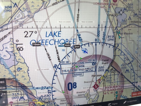


 Entrance to Caloosahatchee on west side of lake and near Clewiston Bloom is all through lake.


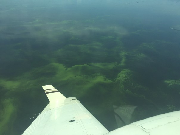


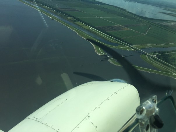


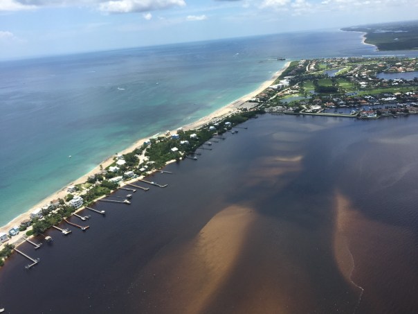


 I recently took trip with my husband; I accompanied him on business to Santa Fe, New Mexico. While I was there, I visited the Museum of Indian Arts and Culture. The museum focused on the remarkable Pueblo people that had originally settled along the Santa Fe River because of its water and transportation. The museum was gifted telling stories, and it got me thinking about the native people who lived around Lake Okeechobee, and how their story is not so well told.


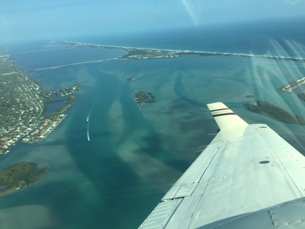


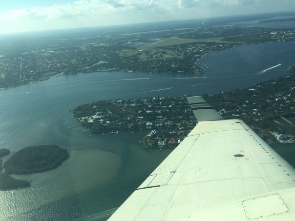


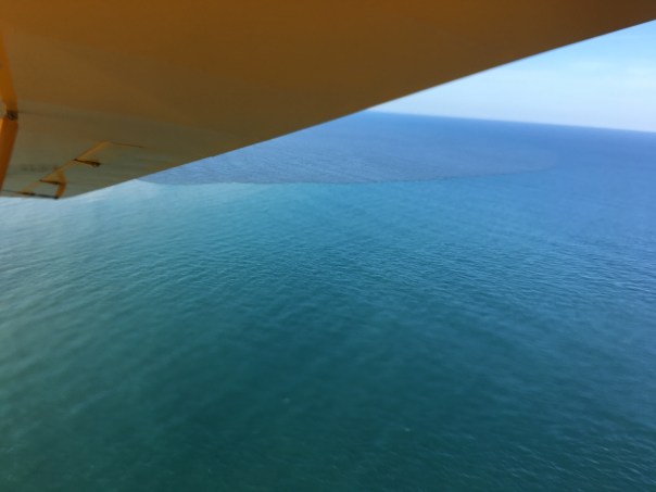


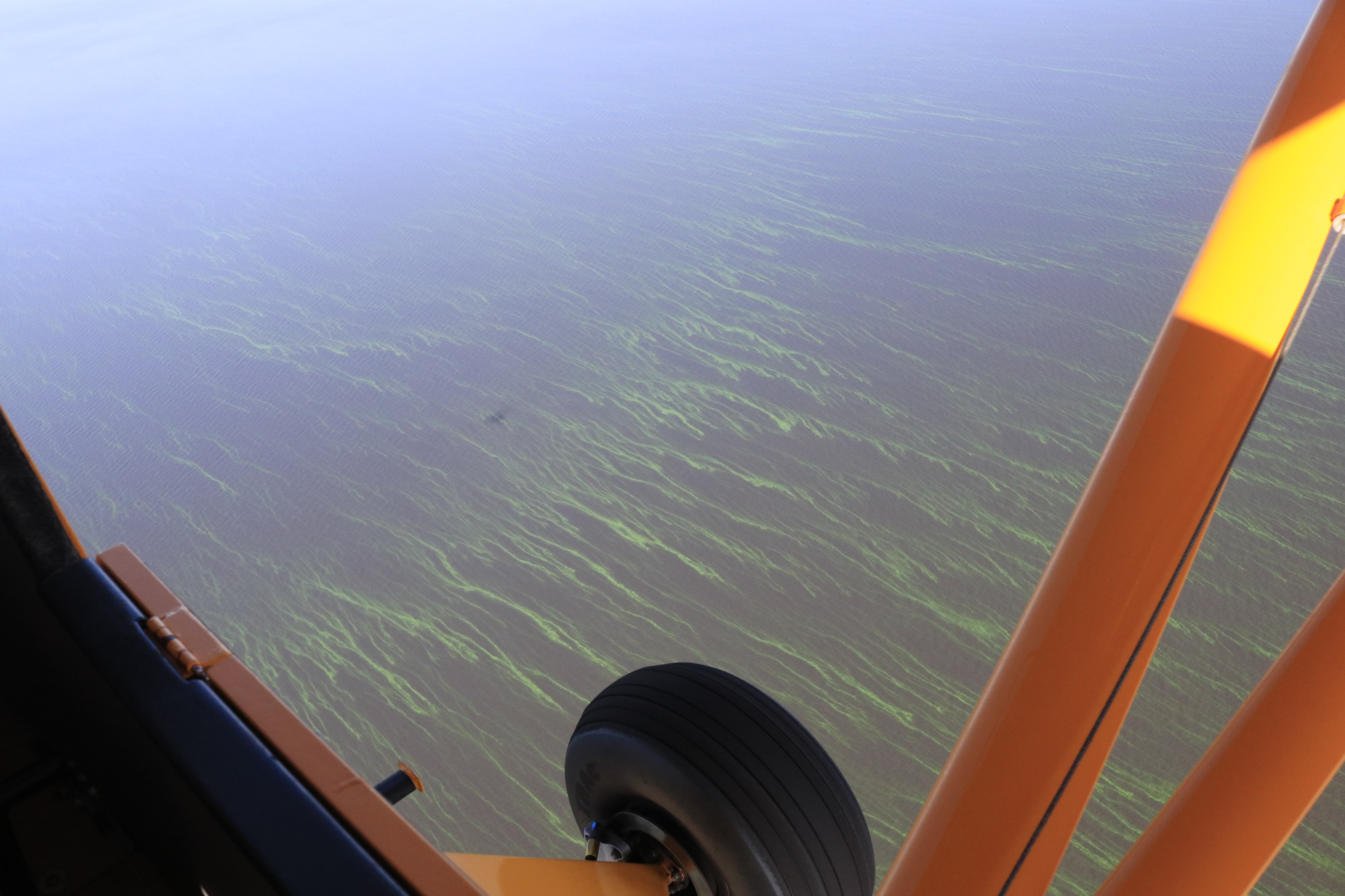


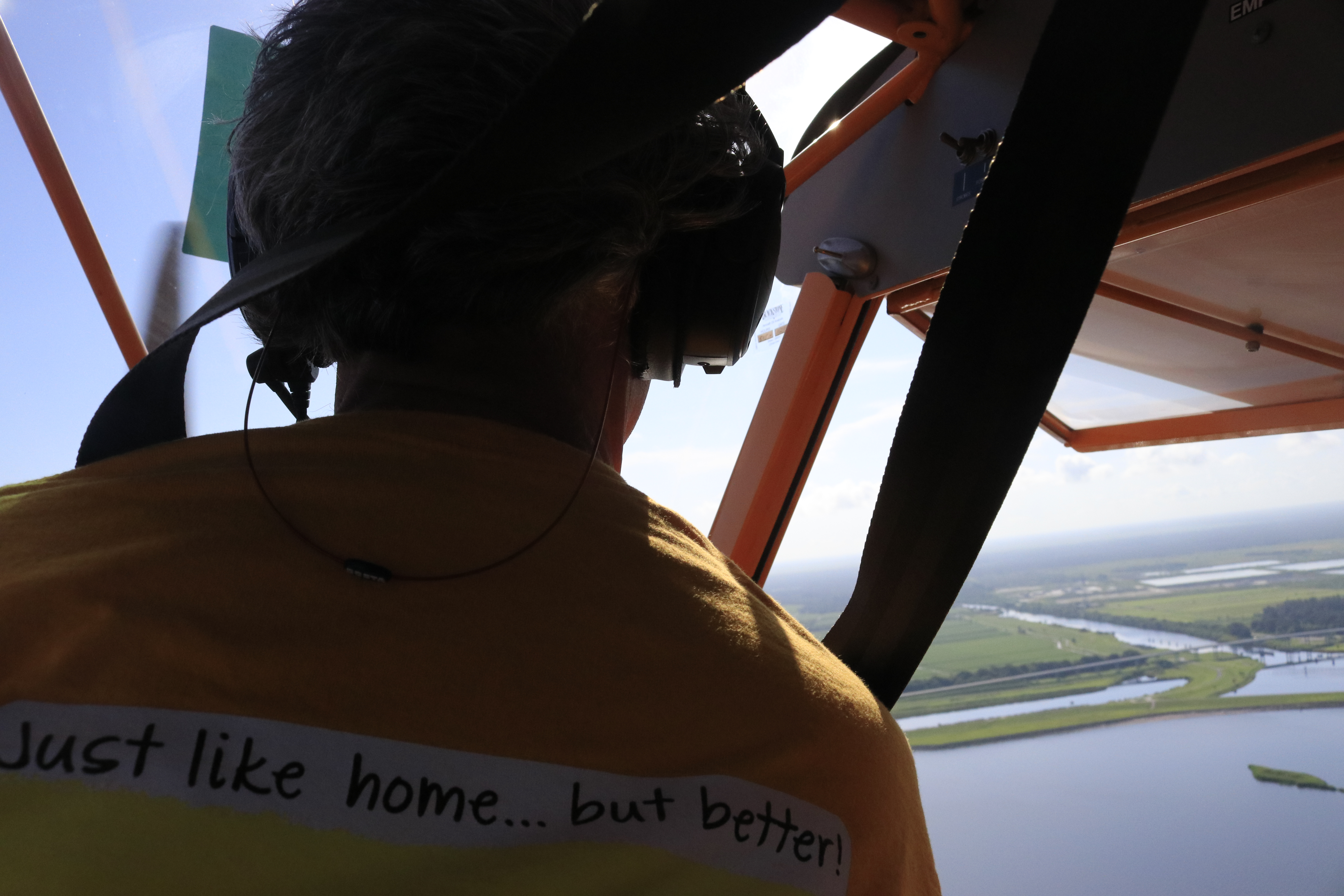


