Images below from Todd Thurlow’s “East Ocean Blvd. & Dolphin Drive 1940, 1958 time capsule flight” reveals the drainage of Witham Field in Stuart, Florida.For some reason as I drive around, I am preoccupied with drainage. Over-drainage that is. I always remember my father’s high school farmer friend Mr Haddad saying to me: “Jacqui, we spent one-hundred years taking the water off the land and we’re going to spend one-hundred years putting it back on…”
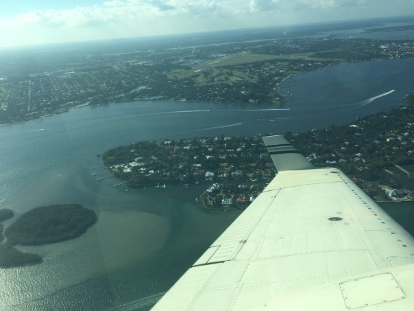
I have been wanting to write something about Stuart’s Witham Field for a long time. I have flown out of it for years, Ed and I going up to take photographs of the St Lucie River/Indian River Lagoon. What a surprise when I finally figured out the ditch behind Ed’s hanger is part of the remains of Willoughby Creek! Aggg!
The land Witham Field sits upon was ditched and drained long ago and parts of the land the airport sits on held the headwaters of Willoughby Creek.
If you’re ever driving east past Witham Field on Monterey Road (714) at Kingswood Drive you’ll notice a fairly wide ditch. This ditch bends east, widening, and then getting skinny again, eventually going under St Lucie Boulevard, and then dumps into the St Lucie River.
-Screenshot of Google Maps showing canal along Monterey and Kingswood Drive dumping to the St Lucie River then turning right to gold course.Another canal goes all along the airport behind the houses on St Lucie Blvd. until the Sailfish Sands golf course. Curving around St Lucie Boulvard, which becomes Indian Street, one will see a restored fork or section of Willoughby Creek and next the bridge going over Willoughby Creek itself. This is the bridge where people often observe manatees.There are more ditches that are off Dixie Highway that lead back into the airport that one cannot see from the road.
-The surrounding lands, especially ponds around Willoughby Creek, once drained into Willoughby Creek. These ponds are long gone and the runoff waters have been directed into small reservoirs and ditches. Thankfully, Martin County has worked hard to improve the water quality in this area.
It remains rather amazing to look back and think on what these lands in the “middle of town” used to be. Large ponds surrounded by wetlands, scrub habitat, and certainly areas of tall sand and slash pine.
Watch my brother Todd’s time capsule flight below to view old Stuart including the lands where the Witham Field sits. Once an oasis for birds, deer, gopher turtles and other wildlife, today it seems like it was always an airport. It wasn’t.
To see the area of Witham Field go to 2:29 in video if you see it below, if not CLICK HERE.
-Ditch on Monterey (714) and Kingswood -Ditch/Canal on Kingwood -Ditch/Canal coming from Kingswood to St Lucie River. Water looks pretty gross. -Other side of St Lucie Blvd. Outfall into St Lucie River. It’s at a speed hump. -Part of restoration of Willoughby Creek on Indian Street. This goes much further back.
-Not a great photo but you see the manatee sign at bridge over Willoughby Creek on Indian Street. The manatees love it here where it is warm and they are protected.
I guess one could say the St Lucie River is getting a new year’s present in that yesterday was the last scheduled release from Lake Okeechobee by the Army Corp of Engineers. The entire situation has a similar theme to an abusive relationship where the beaten thanks their oppressor for finally halting…
Due to Temporary Flight Restrictions (TFR) because of the President’s visit to Palm Beach, it was not possible to fly south along Jupiter Island from Witham Field in Stuart, however, when the wind and runway changed my husband, Ed, was able to get a few aerials at the Crossroads of the St Lucie River and Indian River Lagoon around Sewall’s Point. No seagrass, but the water already looks better.
After being decimated in 2013; part of 2015; toxic in 2016; and experiencing a no-holds-barred discharge rate since September 20, 2017, post Irma; we will continue to fight for the EAA Reservoir’s success and a better 2018 for our St Lucie River.
We shall never, never, never, give up!
Please see links to my brother Todd Thurlow’s website for St Lucie Canal Real Time Flows S-80 Cumulative 2017 and Latest Lake O Satellite Imagery
Today’s blog post, created by my brother, Todd Thurlow, just totally blows my mind. His time-capsule flight through images of Google Earth, historic maps from 1850 and 1940, and an aerial from 1958, takes us on a journey through the extensive pond-land/wetland that used to be the area of Downtown Stuart and beyond. Today we all live here, most of us not even realizing what the land once was…this wetland now “magically” drains into the St Lucie River.
In Todd’s video you can see that Stuart Middle School actually is now sitting where an old pond used to be; there were ponds expanding and contracting with the rains in today’s Memorial Park; there were ponds in the areas of today’s County Courthouse; there were ponds scattered over today’s airport, Witham Field; there were extensive ponds along East Ocean Boulevard and Dolphin as featured in last Friday’s popular blog post. Yes, there little ponds just about everywhere!
Sometimes we think the wetlands are “out west” and they are, but years ago they were also here. I have to say am guilty of this too. When I came home after university in 1986 and just about everything was developed, once again, amnesia! Look, after you watch Todd’s video, and notice the drainage canals around Monterey Blvd., St Lucie Blvd, back by Kingswoods Condo, and on the edges of Witham Field and there are many more. Of course like the grates and drains in every parking lot, these canals drain into our ailing St Lucie River. Lake Okeechobee is the big toxic hammer but there is local destruction too…
She describes a 1958 aerial photograph that hangs in my law office. The photo is from my parent’s “Thurlow/Ruhnke” collection. I had used the photo for a Google Earth presentation for Stuart Heritage on May 8, 2012. http://www.stuartheritagemuseum.com/
This is a recording of maps and photographs used for part of that presentation: 1850s Government Land Office Plats, 1940 USDA aerials and the 1958 Thurlow/Ruhnke photo.
There is no sound or text overlays but here are a few features to note:
0:50 –What was called the “Stuart Middle School Pond”. We jumped in that pond on the last day of school to celebrate graduating from 8th grade. A few years ago the pond was filled in to make room for a new building.
1:00 – The end of Fourth Street (what is now called East Ocean Blvd). East Ocean Blvd. ended at the intersection of St. Lucie Blvd/ Oriole Ave. on the left (north) side and Dolphin Drive on the right (south) before it was extended to the “Bridges to the Sea”.
1:14 – The oblique aerial described in Jacqui’s blog. Note the building in the bottom right corner. That is the Broadway Service Center which still stands today. See https://goo.gl/iODQwU
1:47 –The Evan’s Crary Bridge (aka the Ten Cent Bridge) under construction in the background
2:24 – 1940 flyover of Dolphin Drive. Note the single building in the middle of nowhere. That residence is still standing on the corner of SE 6th Street and Flamingo Ave. According to the Martin County Property Appraiser, it was built in 1925, years before the photo was taken.
2:30 –The 1940 view before our current airport. The previous Krueger Airport was off of East Ocean Blvd. Dolphin Drive continued all the way from East Ocean Blvd. to St. Lucie Blvd. by the river. If you have ever taken the “back exit” from the Stuart Air Show onto St. Lucie Blvd, that still existing right-of-way is what used to be the other end of Dolphin Drive.
~Todd Thurlow
Thomas H. Thurlow III
“Time Capsule Flights,” created by my brother, Todd Thurlow, has been a shared favorite on my blog since 2014. In these remarkable videos, Todd uses his legal and historical knowledge to create a living collage juxtaposing historic and modern-day images to achieve dramatic insights into watershed and land use changes in Florida over the past hundred years. These videos are a must for anyone wishing to understand our state’s history or working to restore its waters and lands in the future. You can access all of Todd’s videos here: http://maps.thethurlows.com.
1940s Dept. of Ag. aerials Martin Co. Dark areas are ponds/wetlands.
Witham Air Field in Martin County is north, just outside of the circles….the circles that designate “No Fly Zones”during Presidient’s Trump’s return home today to Mar-a-Lago in Palm Beach. Many Palm Beachers will be flying into Witham who can’t get into Palm Beach due to the flight restrictions. Perhaps as they pass through they will be learning about the vociferous but sleepy little town of Stuart, to their north, with the toxic water problems stemming from discharges from Lake Okeechobee?
Martin and Palm Beach counties have a long history. In fact, Martin County was formed of north Palm Beach County in 1925. Our destiny is connected…
Looking at the circles on the “Temporary Fly Restriction” map above, sent to my husband, reminded me of some other circles that are also causing a stir. Senate President Joe Negron’s proposed circles for land purchase in the EAA. I know you are familiar with that map! I hope President Trump reads the local paper while he’s here. Or maybe he’ll even get a chance to meet with the President of the Florida Senate?
As we know, in today’s world, anything can happen…
Circles showing Senate President Joe Negron’s proposed land purchase in the EAA
Below is an explanation of the NO FLY as explained by Palm Beach Post reporter Eliot Kleinberg, January 24, 2017
Planned flight restrictions when President Trump is at Mar-a-Lago:
A “no fly” zone in a 1-mile radius. Commercial flights that normally would leave or arrive on a straight line from PBIA must instead angle north or south.
A ring of 10 nautical miles bars all private planes from landing at either PBIA or Lantana unless they came from a “gateway airport,” at which they’ve been screened by the Transportation Safety Administration. Any planes that land at Lantana can’t leave until Trump is gone.
A ring of 30 nautical miles allows only planes traveling to or from fields outside the 10 mile ring, all of those closely monitored by air traffic controllers.
Banned at Lantana during visits: all flight training, practice approaches, parachuting, and flights of aerobatic aircraft, gliders, seaplanes, ultralights, gliders and hang-gliders, balloons, and even crop-dusters. Also banned: banner-towing and sightseeing, maintenance test flights, model rockets and aircraft, utility and pipeline surveys and drones.
A ring of 10 nautical miles bars all private planes from landing at either PBIA or Lantana unless they came from a “gateway airport,” at which they’ve been screened by the Transportation Safety Administration. Any planes that land at Lantana can’t leave until Trump is gone.
And a ring of 30 nautical miles allows only planes traveling to or from fields outside the 10 mile ring, all of those closely monitored by air traffic controllers.
More ominously for Lantana: the restrictions ban from that airport, at leeast while Trump is in town, all flight training, practice approaches, parachuting, and flights of aerobatic aircraft, gliders, seaplanes, ultralights, gliders and hang-gliders, balloons, and even crop-dusters. Also banned: banner-towing and sightseeing, maintenance test flights, model rockets and aircraft, utility and pipeline surveys and drones.
Below is the Report from https://www.aopa.org : Over Palm Beach, FL beginning Friday, February 3, 2017(((Change in times)))
30 NM RADIUS TFR
Location
On the PALM BEACH VORTAC (PBI) 094 degree radial at 1.6 nautical miles.
From the surface up to but not including 18,000 feet MSL.
2 NM EXCLUSION
Location
On the PALM BEACH VORTAC (PBI) 349 degree radial at 30.9 nautical miles.
From the surface up to but not including 18,000 feet MSL.
Location
On the FORT LAUDERDALE VOR/DME (FLL) 004 degree radial at 7.4 nautical miles.
From the surface up to but not including 18,000 feet MSL.
Times:
4:15 PM local Friday, February 3, 2017 until 11:30 AM Monday, February 6, 2017
10 NM RADIUS NO-FLY ZONE
Location
On the PALM BEACH VORTAC (PBI) 094 degree radial at 1.6 nautical miles.
From the surface up to but not including 18,000 feet MSL.
Times:
4:15 PM local Friday, February 3, 2017 until 11:30 AM Monday, February 6, 2017
Affected Public Use Airports
KPBI Palm Beach Intl
KLNA Palm Beach County Park
F45 North Palm Beach County General Aviation
KBCT Boca Raton
No pilots may operate an aircraft in the areas covered by this NOTAM (except as described).
Except as specified below and/or unless authorized by ATC in consultation with the air traffic security coordinator via the domestic events network (DEN):
A. All aircraft operations within the 10 NMR area(s) listed above, known as the inner core(s), are prohibited except for: Approved law enforcement, military aircraft directly supporting the United States Secret Service (USSS) and the office of the President of the United States, approved air ambulance flights, and regularly scheduled commercial passenger and all-cargo carriers operating under one of the following TSA-Approved Standard Security Programs/Procedures: Aircraft Operator Standard Security Program (AOSSP), Full All-Cargo Aircraft Operator Standard Security Program (FACAOSSP), Model Security Program (MSP), Twelve Five Standard Security Program (TFSSP) All Cargo, Or All-Cargo International Security Procedure (ACISP) and are arriving into and/or departing from 14 CFR part 139 airports. All emergency/life-saving flight (medical/law enforcement/firefighting) operations must coordinate with ATC prior to their departure at 561-684-9047 to avoid potential delays.
B. For operations within the airspace between the 10 NMR and 30 NMR area(s) listed above, known as the outer ring(s): All aircraft operating within the outer ring(s) listed above are limited to aircraft arriving or departing local airfields, and workload permitting, ATC may authorize transit operations. Aircraft may not loiter. All aircraft must be on an active IFR or VFR flight plan with a discrete code assigned by an air traffic control (ATC) facility. Aircraft must be squawking the discrete code prior to departure and at all times while in the TFR and must remain in two-way radio communications with ATC.
C. All flight operations not covered in paragraph A. within the 10 NMR area must be security screened by TSA at a gateway airport prior to arriving or departing Palm Beach International Airport (KPBI). Aircraft operators must register with the TSA for gateway screening no less than 24 hours prior to their scheduled departure time. Reservations for screening may begin on February 01, 2017 and last through the duration of the event by calling TSA at 561-616-9650.
D. Gateway airports have been created at Palm Beach International Airport (KPBI), Orlando International Airport (KMCO), Fort Lauderdale International Airport (KFLL), Dulles International Airport (KIAD), Teterboro Airport (KTEB), and Westchester Co. Airport (KHPN) by TSA to accommodate aircraft arriving or departing Palm Beach International Airport (KPBI).
E. TSA screening will not be available on Friday 2/3/2017. TSA screening will be available from 1702041300 UTC (0800 local 02/04/17) to 1702042200 UTC (1700 local 02/04/17), 1702051300 UTC (0800 local 02/05/17) to 1702052200 UTC (1700 local 02/05/17), and 1702061300 UTC (0800 local 02/06/17) to 1702061500 UTC (1000 local 02/06/17). Pilots, crew and passengers must provide valid government-issued photo identification to the TSA at the gateway airport. Gateway screening will include id verification and vetting of all pilots, crew and passengers, screening of persons and baggage, and inspection of the aircraft. No firearms on board aircraft will be authorized.
F. On departure from a gateway airport aircraft must maintain radio contact with ATC and continuously squawk an ATC-assigned discrete code. Intermediate stops while enroute are not authorized unless an emergency exists.
G. The following operations are not authorized within this TFR: flight training, practice instrument approaches, aerobatic flight, glider operations, seaplane operations, parachute operations, ultralight, hang gliding, balloon operations, agriculture/crop dusting, animal population control flight operations, banner towing operations, sightseeing operations, maintenance test flights, model aircraft operations, model rocketry, unmanned aircraft systems (UAS), and utility and pipeline survey operations.
H. FAA recommends that all aircraft operators check NOTAMs frequently for possible changes to this TFR prior to operations within this region.
Coyotes are one of the most adaptable animals on the planet and have made their way to the Indian River Lagoon. (Public photo, ” Florida coyotes.”)
Coyotes are here along the St Lucie River/Indian River Lagoon.
Coyotes were historically associated with the American West, but now they are now in most states and have been reported in 66 of 67 Florida counties, other than Monroe. There is no one to thank for this but humans. With the near eradication of the the American wolf and family of big cats related to the mountain lion since the 1800s, coyotes have no natural predators, other than man, and thus the coyote has flourished.
Most recently, along the Treasure Coast you many have read about Indian River County using cameras to see if coyotes are raiding sea turtle nests, or the controversial trapping and killing of the coyotes at Witham Field in Stuart interfering with plane landings, or the many residents in Palm City or western St Lucie County, who say they hear coyotes howling at night. Coyotes have also, within the past six months, been reported in the Town of Sewall’s Point, in the vicinity of South River Road on the south end, and Castle Hill in the north.
Photo of coyote in south Sewall’s Point on River Road. (Courtesy of Sewall’s Point Police Department, 2014.)
As a long time resident of Sewall’s Point, I love the wildlife and encourage all to live in harmony with these animals. They are God’s creatures and they keep the rat population down! I have seen both grey and red foxes, as well as many bobcats. I have friends who swear in Sewall’s Point’s earlier days, they witnessed panthers.
But I have yet to see a coyote. Unlike native bobcats who are solitary animals, unless mating or raising young, coyotes usually hunt in pairs and belong to a pack of about six members.
Coyotes are in the dog family and are related to wolves, foxes and domestic dogs. Coyotes and dogs can mate although this is unusual as coyotes have specific social ties and mate only once a year. When dogs and coyotes do mate, the hybrid offspring is called a “coydog.” Coydogs are well documented out west and are said to make poor pets, as more often than not, they are very high strung.
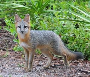
The photo below is a grey fox for comparison. Coyotes are taller and weigh more than foxes; in our area sometimes weighing up to 30 pounds, whereas a fox may be closer to 12.
Grey fox. Both grey and red foxes are much smaller than coyotes. (Public photo.)
Should we be scared? I don’t think so. We just need to be smart, coy and cautious, like the coyote.
Many Native American myths laud the craftiness of “coyote” and often in Native American mythology, he is so respected, he is portrayed as the “Creator.” He is respected for being “ubiquitous,” as he is so successful, “he appears to be everywhere at once,” or “seems to appear everywhere at the same time.” He is not to be outsmarted.
One thing for certain, now that coyote is here, chances are, he will not go away. We must learn to live with him by keeping our distance, not leaving pets out for long periods unattended, in the evening or early mornings, and by not feeding him. He is smart enough to feed himself.
It is said we all have a bit of fear in our inner most nature, as the collective memory recalls the earlier times of fires and wolves, but then humankind tamed the wolf and hence today, we have “man best friend,” our dogs.
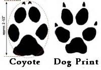
Coyote/Dog tracks
Remember that the coyote is related to dogs if you see him, and if you look him in the eye ask for a sliver of his adaptability and success surviving on an ever changing planet and an ever changing Indian River Lagoon.
I added this photo from Dr Gary Goforth 8-13-15 that was taken this February in Foxwood off 96 A in Martin County.
MOULTRIE DIGITAL GAME CAMERA G. GoforthMOULTRIE DIGITAL GAME CAMERA G.Goforth
_______________________________
I added this link on 8-13-15 written by my classmate Angeline Scotten whom I met last week at the UF Natural Resouces Leadership Institute. She is an expert on the subject of coyotes for the Florida Fish and Wildlife Commission. This article was written for Hernando County but certainly applies to us as well. I found it very informative. (http://hernandosun.com/coyotes_in_hernando)

 For some reason as I drive around, I am preoccupied with drainage. Over-drainage that is. I always remember my father’s high school farmer friend Mr Haddad saying to me: “Jacqui, we spent one-hundred years taking the water off the land and we’re going to spend one-hundred years putting it back on…”
  Another canal goes all along the airport behind the houses on St Lucie Blvd. until the Sailfish Sands golf course. Curving around St Lucie Boulvard, which becomes Indian Street, one will see a restored fork or section of Willoughby Creek and next the bridge going over Willoughby Creek itself. This is the bridge where people often observe manatees.There are more ditches that are off Dixie Highway that lead back into the airport that one cannot see from the road.

 -Ditch/Canal on Kingwood
 -Ditch/Canal coming from Kingswood to St Lucie River. Water looks pretty gross.
  -Other side of St Lucie Blvd. Outfall into St Lucie River. It’s at a speed hump.
 -Part of restoration of Willoughby Creek on Indian Street. This goes much further back.
 -Not a great photo but you see the manatee sign at bridge over Willoughby Creek on Indian Street. The manatees love it here where it is warm and they are protected.