These aerial photographs were taken by my husband, Ed Lippisch, on Friday, February 24, 2023 around 1:51 pm during high tide. It was a beautiful day and many boats were fishing over the nearshore reefs. The 500 cubic feet per second discharges are much less noticeable at high tide; the visual loss of seagrass remains. I am sharing all photographs -many are very similar, you can look for small differences.
Please see slides from ACOE Periodic Scientist Call on 2-21-23 for updates on Lake Okeechobee level, red tide on west coast, east coast conditions, and other important information. Periodic_Scientists_Call_2023-02-21
With the hot, dry weather the last few days Lake Okeechobee’s evaporation should be high. Today the SFWMD reported the lake at 15.61 feet. You can see the ecological envelope band in gray below.
~Ed’s Aerial Report 24 days after discharges begin at 500 cfs via ACOE from Lake Okeechobee to SLR/IRL. Documenting the Discharges.
My husband Ed Lippisch has asked me to get these photos on-line ASAP. They were taken of the St Lucie River/Indian River Lagoon area around Sewall’s Point, yesterday, February 15, 2023 around 1:25pm. It was an incoming tide about two hours after low tide. I do not have time to go through all the photos so I am sharing all of them. Many are almost identical. Color doesn’t look great. No seagrasses visible. Salinity remains in range according to FDEP. See my brother Todd’s website EyeonLakeO.com for more information.
Today is Ed and my 18th year anniversary. I don’t have a lot of time to go through Ed’s recent photos as we document the discharges so I am just going to post all -of the St Lucie River/Indian River Lagoon from February 8, 2023 taken around 1:23 pm. There are only subtle nuances between them. The ACOE started discharging 500 cfs from Lake Okeechobee on January 22, 2023. You can see the effects in these photographs. The water is able to clear near the St Lucie Inlet at this time. No seagrass in sight. Please see previous post to compare. I will write more soon.
Some months ago, the original “River Warrior” Piper Cub was replaced with a Super Cub. Because the Super Cub is so much more powerful, more like a helicopter, it is much windier in the back of the plane, where I sit. I almost dropped my beloved iPhone, many times, before I gave up….
I have had to replace my lightweight and versatile iPhone with a “real” camera as the weight of the camera is stabilizing. Today, I share some of my other aerials of the St Lucie/IRL Region from 3-2-19, taken with this heavier camera. I thank my husband Ed for “giving me wings.” Over the coming months, as I adapt, we shall begin to document all of Florida’s east coast. First, here’s home!
Photo Ed Lippisch, Jacqui with new camera over barren seagrass beds, Sailfish Flats. Looking towards North Hutchinson Island, nearshore reefs, JTL Sailfish Point at St Lucie Inlet, JTL Atlantic Ocean looking east, JTL IRL and Jensen Beach Bridge, looking east, JTL Hutchinson Island, Sailfish Point, IRL, Sewall’s Point in distance. Sailfish Flats lie between. JTL Barren Sailfish Flats, JTL Indian River Plantation and Cove, Marriott, JTL IRL, St Lucie Power Plant in background. JTL IRL- Birds on a sandbar? No, a regatta! JTL The Savannas, near Jensen, behind Indian River Drive, JTL Savannah Road and US 1 leading to St Lucie River’s Roosevelt Bridge, Stuart, JTL Expanding Town of Ocean Breeze Park, IRL, JTL Rio/Jensen, Warner Creek, peninsula of Sewall’s Point, Stuart proper and airport, JTL Destructive C-23 canal separating Martin and St Lucie Counties across from North River Shores, SLR, JTL Dixie Highway and train track, JTL US 1 Roosevelt Bridge, discharges from LO coming through – see sediment…
Circling back over the IRL and US Sailing Center’s regatta, a beautiful sight!
The remaining photos are coming in for landing circling over the St Lucie at Roosevelt Bridge and developed lands…
Looking towards Palm City over SLR
Please note all comments become part of the Public Record.
Chase with a tarpon he recently caught and released, St Lucie River/Indian River Lagoon region. Photos courtesy of Chase’s iPhone, 5-24-17.
Happy 17th Birthday to Chase! If you don’t already know him, Chase is one of Stuart’s leading sports fishermen, in any age category. This photo is of a recent catch of my favorite fish, the beautiful and unforgettable, “Silver King Tarpon.”
Since Chase was thirteen years old, when we ran into each other, he would share photos of his fishing expeditions. I always stood there, mouth wide open…”Are you kidding me?” I would ask. He would just smile with his wide, blue eyes saying it all:” THIS IS NO FISH STORY…
In 2015, Chase and I, together with many others tried to save a pigmy whale that had beached at Stuart. Chase loves the outdoors and has respect for all of the water’s creatures.
Yesterday, in Jensen, I ran into Chase celebrating his 17th birthday with family and friends.
Perhaps it is his mother’s wonderful name, “Cobia,” that inspires her son! 🙂
If you are a reader of my blog you know, the ancient, acrobatic, and historic tarpon is my favorite fish as it was the original sports fish of the St Lucie River/Indian River Lagoon, until its numbers were destroyed by canals, C-44, C-23, C-25 and C-25. Had these canals not been allowed to decimate our river, Tarpon would still be King, not the famous off-shore Sailfish….
Thank you Chase for sharing and inspiring us all! We know you have a great future ahead of you!!!! I can’t wait ’til you have your own show!!!!!!
Chase w/Tarpon . What a beautiful fish!Chase w/Tarpon!Tarpon Fishing in the St Lucie River/S. Indian River Lagoon ~ by famed artist or the time, Kent Hagerman, 1893-1978. Image courtesy, Sandra Henderson Thurlow archives.
Canals in Martin and St Lucie Co.: C-23, C-24, C-25 constructed in the 50s and 60s. C-44 connected to Lake Okeechobee, the worst, constructed in the 1920s. These canals, assisting agriculture and development, destroyed the “fishing grounds of presidents” from the early 1900s, the famed St Lucie River. In the 30s and 40s the offshore Sailfish was marketed and Stuart became known as the “Sailfish Capital of the World” as so many of the tarpon and other fish of the river had declined. The tarpon was forgotten as the original main game fish of the St Lucie River. May he rise again! JTL
4th Street/East Ocean Blvd 1957, Stuart, Florida, Arthur Ruhnke. Courtesy archives of historian, Sandra Henderson Thurlow.“See that white strip just below the wetland? That is the extension of Flamingo Drive that skirts the pond behind the old car wash. They just dug a retention pond and conducted the water to it. All of that pineland is covered with condominiums today.” (Cedar Point, Vista Pines, and Kingswood)~ Sandra H. Thurlow
Today we drive over the Indian River Lagoon and St Lucie River surrounded by “civilization,” and forget that once it was once a wetland and pine forest full of wildlife. In the course of a lifetime, these things are long forgotten.
The above 1957 photograph hangs in my brother’s law office. When I visit him, I find myself staring at it for long periods of time. It is one of those rare photos that really puts things into perspective. The road construction through the wetlands, (note it going through the pond, and pine forest) was all taking place around the same time that the “Bridges to the Sea,” from Stuart to Sewall’s Point, and Sewall’s Point to Hutchinson Island, were completed. It’s amazing to see what the landscape once looked like. The road in the photograph, Fourth Street, was renamed “East Ocean Boulevard” in 1960, and is a major thoroughfare to the beaches today.
Jenny, Todd and I 1973, alligator in background.I remember early East Ocean Blvd, although it was already quite changed by the time I was born in 1964. My family lived at 109 Edgewood Drive in Stuart, a short distance away from these wetland ponds under development. I recall Scrub Jays in our back yard and feeding them peanuts. By 1974 the family moved across the river to Sewall’s Point “growing and improving” with the changing landscape.
By 1979, when I was fifteen years old, riding my bike over the bridge to Stuart to work at the Pelican Car Wash, the beautiful wetland pond had been relegated to a retention pond for run off. Over the next two decades, you didn’t see wetlands and ponds anymore, or wildlife, just condominiums, office buildings, and shopping plazas. The state four-laned East Ocean Boulevard and built higher bridges to the ocean too.
Believe it or not, the pond in the aerial is still located behind a gas station that used to be the car wash. It is not even a shadow of its former self. Two days ago, I drove by and noticed that there was an extensive algae bloom in the pond backed up to the parking lot and gas pumps; the water reflecting a sickly shade of green.
I sat there thinking about the long forgotten pond in the middle of East Ocean Boulevard in the photo I love in my brother’s office, wishing the developers had figured out a way to go around the pond. As the shortest distance between two points, over time, is not always a straight line.
East Ocean Blvd 1957, courtesy historian, Sandra Henderson Thurlow
Flamingo and retention pond at Flamingo and East Ocean 2017, once a wetland.Google map of East Ocean Blvd. through what was once wetland and forest, 2017.1940s Dept of Agriculture photographs of Martin County showing wetlands. Courtney Todd Thurlow and UF archives.Overlay 1940 aerials over Google map today, Todd Thurlow.USDA History of Wetland Development in Florida: https://www.nrcs.usda.gov/wps/portal/nrcs/detailfull/fl/newsroom/features/?cid=stelprdb1252222
5-7-17: Hutchinson Island along the Atlantic Ocean and confluence of the St Lucie River/Indian River Lagoon, blue waters, seagrass not yet revived from 2013 and 2016 Lake O discharges. Photo Ed LippischMy husband’s flight yesterday over the Atlantic Ocean, St Lucie Inlet, and St Lucie River/Indian River Lagoon is beautiful. But look carefully and you will see a light-colored brownish plume at the mouth of the St Luice Inlet entering the ocean. Finally after months of drought, it has begun raining. And when it rains… (mind you C-44 connecting the St Lucie River to Lake Okeechobee is closed now) the re-directed run-off of waters from canals C-23, and C-24 of course still flow into our St Luice River/Indian River Lagoon.
These canals organized and built during the 1950s and 60s are part of the Central and South Florida Flood Project that the Army Corp built following the hurricane and extensive south Florida flooding of 1949. The run-off waters from these canals and the local watershed are what you see in today’s video.
As damaging as C-23 and C-24 are (they too must be reworked and redirected) they are not the damaging discharges from Lake Okeechobee that throw the St Lucie over the brink as in 2013 and especially 2016 when toxic algae covered extensive portions of the entire St Lucie.
Rio, St Lucie River, Jeff Tucker, toxic algae
…
…
3
Shoreline of Sewall’s Point, Tracy Barnes 6-25-16
…
(Photo mosaic from 2016 shows various photos by Dr Scott Kuhns, Rebecca Fatzinger, (wildlife) JTL/Ed Lippisch, pilot Dave Stone and others.)
In spite of the light brown plume, the short video flight from Jensen to Peck’s Lake shows blue waters near the inlet and mouth of the estuary as it should be, not black water. If Governor Scott does not veto the budget, the reservoir in years to come will help offset the Lake Okeechobee destruction and open the way to truly “send the water south.” #ThankyouJoeNegron
This is very exciting, but believe me, this is no time to let down your guard, as the fight for control of Florida’s waters has really just begun.
Reef system off Sailfish point is covered in black water, sediment, and nutrient pollution when Lake O is discharging. Here after months of drought, and finally some rains we can see the reefs. 5-7-17, Photo Ed LippischMap SFWMD showing canals and basins. Note S-308 or structure s-308 at Lake O and S-80 down the C-44 canal AKA the St Lucie Canal. Both of these structures have to open to allow water to flow into the C-44 canal to the St Lucie River, Indian River Lagoon. All canals are destructive to the St Lucie/IRL yet it is C-44’s Lake O that puts the St Lucie system in complete and total overload.DEP C-23:http://www.dep.state.fl.us/southeast/ecosum/ecosums/c23.pdf
Osprey with fish, St Lucie River, courtesy of Todd Thurlow
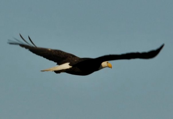
As much as I romanticize my youth along the St Lucie River/Indian River Lagoon in the 1960s, 70s, and 80s, one thing I did not see were birds of prey. Populations had plummeted here and across our nation. The use of DDT, for mosquito control, especially, had drastically reduced bird populations. I truly do not recall even once seeing an osprey fly over the Indian River Lagoon when I was a kid….Hard to believe, isn’ it?
Today, forty years later, every single time I walk the Ernie Lyons Bridge to Hutchinson Island I see multiple ospreys sitting on light posts and diving like missiles into the shallow waters of the Indian River Lagoon. On the Roosevelt Bridge in Stuart there is a resident osprey I count on seeing each time. He sits on the railing completely unaffected by the stream of civilization passing by. Last week, while driving home from Belle Glade, I saw a bald eagle near the Dupuis Wildlife Management Area. “An eagle!” I exclaimed out loud pulling over my car to watch its unmistakable white head and magnificent wing span glide over the tops of the pine trees. “Amazing…” I thought to myself.
The point is, good things happen. Good things are happening now too, but like the birds of prey we may not see the difference until many years have passed. Have hope. Know your work is making a difference for our river and our environment. Things can change for the better. The osprey and the eagle, they are proof. When you see them, be inspired!
Photo by Greg BraunHarbor Ridge eagles, Scott Kuhns
Courtesy of “Historic Jensen and Eden of Florida’s Indian River,” Sandra Henderson Thurlow
When I was kid growing up in Stuart, I remember seeing a lot of cottages. I loved these structures ~so simple, efficient, and adorable too. I remember cottages at Frances Langford’s Outrigger Resort just north of Sewall’s Point; I remember cottages in Rio along Dixie Highway; and I recall the cottages along Indian River Drive in Jensen at the old Pitchford Camp. Somehow the more run down they were, the cooler they appeared. A reminder of days long past before Martin County developed and we were all brainwashed of the need to build bigger houses and complicate our lives.
Today, when one hears the name “Pitchford,” one may envision a Martin County Commission embroiled in a decade of controversy, but this wasn’t always the case. In fact in the early 1900s the name “Pitchford” was a family name that defined “good times” of fishing, dancing, and playing shuffle board along the beautiful and healthy Indian River Lagoon.
Recently, I was invited by long time friend of my parents, Boo Lowery, to see his modern-day, old-fashioned, fish camp. Boo, himself, an “old-timer” is related to many of the early families of the Stuart area. Boo’s career as a respected contractor working closely with famed architect, Peter Jefferson, allowed him to become an expert in building, moving, and renovating homes.
In the 1980s when the cottages at Pitchford Camp were going to be demolished, Boo, who along with his wife Soo is a “lover of all things vintage” stepped in and saved five of the Pitchford Camp cottages. Over time, the little structures have been moved alongside land where a “borrow pit” (dug to build part of I-95) was located. This hole in the ground, today, is a serene pond in the middle of a pine forest, and a living museum housing the Pitchford cottages and of a way of life along our waterways that no longer exists.
It was so much fun going to Boo and Soo’s and today I am sharing some of my photos. While eating hush puppies and alligator, I told my husband, Ed, “I could live in one these cottages.” That I wanted to live in one of these cottages! He looked at me like I was out of my mind… Perhaps, he thinks I’m too soft and spoiled by “progress.” Maybe I’m dreaming, but I think I’d love it. I think I’d be as “happy as a clam…”
In any case, enjoy the photos of this very special place and thank you Boo and Soo for holding on to the old ways and for keeping our Indian River Lagoon history alive.
“Robert McClinton, “Doc, ” Pitchford was the only remaining Pitchford brother after Herbert’s death in 1988. When Doc died in December 2001, it was the end of an era. Doc tried to hold on to the old ways and was quite successful. The Pitchford holdings were like a time capsule surrounded by computer-age progress. Although most of the original Pitchford Camp cabins were demolished….”
Boo saved a few!
(Excerpt and photo below from my mother, Sandra Henderson Thurlow’s book “Historic Eden and Jensen on Florida’s Indian River.”
S-80 dumps from Lake O into the SLR, image created by Doc Snook, 2013.Regarding Senate Bill 10, and the recent changes made to the bill~
I thought I would just go on-line and compare the first bill to the second with its amendments…kind of like juxtaposing town ordinances between first and second reading. Well, I learned over the past week, that this is not as easy as I had anticipated. In fact, to interpret well, I think I need a lawyer, or to become one.
Nonetheless, today I have gathered information to help us understand what is/has happened with Senate Bill 10. The essence of its changes is encapsulated in these recent words by Senate President Joe Negron about the bill:
“Harmful discharges from Lake Okeechobee have flooded communities on the St. Lucie and Caloosahatchee Rivers with massive amounts of toxic algae that destroyed estuaries and harmed the local and state economies. Unfortunately, incidences like these are not unique in our state and are a symptom of the lack of attention to water resource development. The lost summer must be a wakeup call for all Floridians.”
Powerful words from a Senate President. And between the lines we see that he is trying to build bridges to garner more support…as the powers that be have been repeatedly clubbing the bill over the head, in form with their outdated ideology.
So the bill has changed, it may be slightly wounded but it is still alive, and the dramatic destruction of our St Lucie/Indian River Lagoon has become the seed of change for our entire state. Wow. This is fitting as Martin County has a history of inspiring change and being a leader when it comes to the environment.
Ernest Lyons, the great “Stuart News” newspaper man, and others are in their graves smiling I am sure. He may even be smoking a cigar.
Nonetheless, we must remain the epicenter of this state-wide change…we must keep foucs.
The toxic destruction from Lake Okeechobee is a not by accident, but a rather a state and federally sponsored decision embedded in a power culture that has ruled for over one-hundred years. It is time to crack this wide open, thus even though the bill is morphing Senate Bill 10 must keep the EAA land purchase and reservoir component.
And although it has grown to include others, it still has this critical component.
Concerns?
The Florida Wildlife Federation states:
“Unfortunately SB10 has been substantially amended to include funding for water supply developments (pipes and pumps)…The bill changes the direction of the state’s major land acquisition programs from conservation purposes, to acquisition and improvements to land and water areas to protect, restore, and DEVELOP, water resources…These amendments are concerning…” I trust FWF’s concerns are warranted and should be looked at.
Now for the fun part! Below you can compare the two bills, it has gone from 14 to 27 pages!
The press releases following help interpret the bill’s intent. Below the Florida Senate links are two reporter’s insights that I feel are quite helpful, Isadora Rangel of TCPalm and Nancy Smith from Sunshine State News.
In closing, we must never give up because we are destined to change the long-standing culture of drainage and destruction for the St Lucie River/ Indian River Lagoon and now for the great state of Florida.
MORE PROJECTS ADDED
Bradley also added projects to garner support from lawmakers across the state. Those include:
• Creating a loan program to help government and private entities pay for water storage projects that prevent it “from being discharged to tide or otherwise lost to protect the waters of the state.” The loan would pay up to 75 percent of the project and give priority to alternative water supply in areas with limited water sources or that are threatened by salt water intrusion.
• $20 million for grants to help local governments convert septic tanks to sewer systems or remove muck in the Indian River Lagoon and the St. Lucie and Caloosahtachee rivers, as Gov. Rick Scott has proposed;
• $35 million per year for the restoration of the St. Johns River and its tributaries or the Keystone Heights Lake Region;
• $2 million annually for septic-to-sewer conversions, stormwater projects, muck removal and other water quality projects in the Florida Keys.
Sunshine State News, Nancy Smith
The Coast-to-Coast Comprehensive Water Resource Program includes the following:
— Acceleration of the timing and funding for the state share of the Everglades Agricultural Area Storage Reservoir Project. The bill authorizes the purchase of land for the project from willing sellers in the EAA and does not authorize the use of eminent domain.
— Funding of the state share of all existing Comprehensive Everglades Restoration Plan (CERP) projects in the integrated delivery schedule (IDS), including the Lake Okeechobee Watershed Project, the C-43 West Basin Storage Reservoir Project, the C-44 Reservoir Project, the Western Everglades Restoration Project, the C-111 South-Dade Project, and the Picayune Strand Restoration Project.
— Direction to the Army Corps of Engineers to begin the reevaluation of the Lake Okeechobee Regulation Schedule to take into account repairs to the dike and new southern storage features to increase storage in the lake as early as possible.
— A new bonding program, building on the Florida Forever model that recognizes the need to bond for water resource protection and development across Florida. The bill transfers the remaining $3.3 billion of existing bonding authority from Florida Forever to the Florida Coast-to Coast Water Resources Initiative. The bill does not create additional bonding capacity.
— A new revolving loan financing program and statutory tools to allow the state, water management districts and local governments, to develop and operate water storage and supply facilities to service regional populations addressing the growing need for water supply in the state.
— Dedicated LATF funding to expand Legacy Florida to include projects addressing water quality and restoration with the St. John’s River and the Florida Keys.
— Funding to aggressively address the retrofitting or conversion to central sewer systems of outdated septic systems consistent with Gov. Rick Scott’s leadership on this issue.
— Provisions that encourage reuse by establishing a water reuse grant program, specifically to assist wastewater treatment facilities to expand capacity to make reclaimed water available for reuse.
A biography of the late Ernest Lyons, Stuart News editor and nationally recognized for his writings in support of the environment and the St Lucie River: http://www.flpress.com/node/63
Committee Members: Senator Bradley, Chair; Senator Book, Vice Chair; Senators Braynon, Hukill, Hutson. Mayfield, and Stewart
Yesterday, January 11th, Florida’s Appropriations Subcommittee on the Environment and Natural Resources met in Tallahassee. The Legislative Session has not formally started, but as most things in life, the most important stuff happens ahead of time….”in committee.”
The topic was “Discussion and testimony relating to the options for reducing harmful Lake Okeechobee discharges and Everglades Restoration.”
This meeting is being held because of Senate President Joe Negrons’ proposal to buy 60,000 acres of land in the EAA south of Lake Okeechobee for a Reservoir.
Yesterdays’ meeting was just informational, but first impressions are very important. And anything can be killed in committee.
I think the meeting went very well. “Everyone was represented:” East Coast; West Coast; Florida Bay; The Glades and agencies or organizations of those who presented. I thought it was great. Great to see people in power and those with knowledge talking about this important issue. Remember that just a few years ago, many in Tallahassee thought the Indian River Lagoon was a movie from the 50s.
Many people drove over 12 hours to speak but Chair Bradley did not allow public comment. Bullsugar, River Kidz, Glades Residents, Islamorada, Florida Bay, CaptainsForCleanWater, Stuart residents, Ft Meyers residents, Realtors, Hotel Owners, Business Owners and more…This is very disappointing, but certainly “The Powers That Be” knew everyone was there, and surely “They” are taking about it behind closed doors. It makes an impression when the chamber is full because those politicians know that for every person there, there are hundreds, if not thousands behind him or her who did not come…The “Powers that Be” know this. And Senator Negron knows who came too. Surely he does. He appreciates this! He is motivated by this!
Having a full-house in a sub-committee room is not an everyday occurrence for these folks. Unlike our county government the State is not as practiced at this. They generally get to operate in a vacuum–Tallahassee being so far away! Not good!
Time was short and messages many, so Chair Bradley decided to cut the meeting presenters basically in half. Thus not all the presenters who came were allowed to speak either.
Those who presented were: Senate lawyer for the committee, Ashley Istler; UF’s Wendy Graham; ACOE’s Lt Col. Jennifer Reynolds; Independent, Dr Gary Goforth; and Exec. Dir of the SFWMD, Pete Antonacci .
Those moved to January 25th were: Dr Tom Van Lent, Everglades Foundation; Drew Bartlett, DEP; and Ernie Barnett, EAA Landowners.
Overall takeaway?
There was a common theme: “we need more water storage everywhere. North, South, East and West and concerns about where the reservoir should first be or if it should be….
This is clearly a very exasperating experience for many. But isn’t it great that we are actually talking and learning about it. Together.
Original locks at Canal Point WPB Canal, JTLWPB Canal built in 1917 at Canal Point, JTL
Survey marker on original lock at Canal Point, WPB Canal. JTLThe beautiful iron and wood work on the original lock at Canal Point’s WPB Canal.IronworkPictured here: The original lock at Canal Point. I think this should be restored as a historic landmark as it was built in 1917 as part of the WBP canal and basically set us on the path we are today and is also a symbol of where we can go. The man on this lock reminded me of the story of the shared swing-bridge at Torry Island that once was part of the Roosevelt Bridge in Stuart. This will be the subject of today’s post.
2016 has been an incredible year, and 2017 will be as well. In 2016, both Lake Okeechobee and the St Lucie River blew up with toxic algae, and #GladesLivesMatter was established as a voice for a way of life that could be lost…
As far as 2017, as I write this post, deals are being cut, and advocates on both sides are working to get legislative support for their positions. But during this season of light, may we also remember our interests, as they hold things we share in common rather than apart: a Healthy Lake Okeechobee and St Lucie River, as well as Local Economic Prosperity for All are certainly goals both the Glades and the Coast desires…right now, in most areas of our combined worlds, this does not exist…
Yesterday, I toured the Glades once again with former Pahokee mayor, J.P. Sasser, someone I don’t always agree with, but definitely get along with. Someone who is teaching me a ton about the Glades, a history linked to my history, the St Lucie River/Indian River Lagoon….
Along the journey, a noteworthy thing happened right of the bat at Canal Point, our first stop. Here, I met an older gentleman fishing along the original locks of the historic West Palm Beach Canal. As I was taking photos, I thought I should introduce myself.
“Hello,” I said, extending my hand.
“Hello.”
“Catching much?” I asked.
“Not today, but usually, yes.”
“Do you live around here?” I inquired.
“No, Tequesta.”
“Wow Tequesta? That’s pretty far away…”
“Not really,” he said. “Maybe thirty minutes. I used to come here with my father in the 1950s.”
“That’s cool.”
“And where are You from?” He inquired.
“Stuart.”
The fishing line bobbed in the water. I saw noticed a dead gar fish float by. The water doesn’t look so good, I thought.
“Have things changed a lot?” I asked.
“Yes they have,” he said, “but not a lot out here at Canal Point. That’s why I come.”
An alligator silently swam the shoreline…
“You know your bridge is here.” the fisherman softly said,” pulling on the line.
“Wow, funny you should know that…my mom…she’s a historian. Torry Island right? They used part of the Roosevelt Bridge in Stuart to build out in here in Belle Glade in 1938. It’s still here today…a swing-bridge….right?”
He looked at me holding his gaze. “Right young lady, the bridge is here….”
J.P. called from the car. The fisherman and I locked eyes.
“The bridge is here.” I repeated.”The bridge is here.”
As we drove away, I wrote something on my notepad: “2017 #GladesCoastMatters … ”
_________________________________________
Torry Island Bridge is located in Belle Glade about a 15 minute drive around Lake O from Canal Point.
“The story of the bridge’s origins flow smoothly from Corbin… The 1928 hurricane that ravaged the Glades set in motion the chain of events that would bring the bridge to Belle Glade. The storm destroyed the original dike that surrounded the lake. To build the replacement dike, the federal government spooned out a canal, separating Torry Island from Belle Glade, and used the dirt for the dike. The new canal, called the Okeechobee Waterway, needed a bridge. In 1938, state contractors built the Point Chosen Bridge, replacing a pontoon bridge with a swing bridge that was built in 1916 and relocated from the St. Lucie River near Stuart. The bridge consisted of the movable portion and wooden trestles on each end.” Associated Press article, 2009.
Merry Christmas and Happy Holidays to all my readers! See you in 2017!
Jacqui
This is the swing bridge that used to be in Stuart on the Roosevelt Bridge but is now part of the Torry Island Bridge in the city limits of Belle Glade.Torry Island, Belle Glade.The swing-bridge looking across the rim canal around Torry Island.The Bridge Between Us…JP and JTL.J.P.’s bumper sticker
My bumper sticker/sHistoric map of the Glades showing cities. Canal Point upper left and Belle Glade further west and south. WPB canal is in Canal Point and the Torry Island Bridge is in Belle Glade.
Today’s Canal Point is easy to drive right through on one’s way to Pahokee, but the little town has an important past and seeded a great future. As we learn about it, we learn about ourselves, all part of South Florida’s giant drainage and development scheme that continues today. In the future, together, we must work to improve water quality that has been destroyed by development of the Everglades. In studying this area, one thing is clear, almost all has fallen away except the USDA Department of Agriculture Sugarcane Station still standing today, almost 100 years later: https://www.ars.usda.gov/southeast-area/canal-point-fl/sugarcane-field-station/
So how did Canal Point get on the map?
According to the book, Black Gold and Silver Sands, by James D. Snyder, Gilbert A Watkins, an expanding lumber dealer from “nearby” West Palm Beach, acquired lands in the area after 1896 when Hamilton Disston, (the man who first drained Florida’s swamp) died. The lands purchased by Watkins included 4,337 acres near the eastern lakeshore of Lake Okeechobee. Disston’s Southern States Land and Timber owned all the even-numbered, square mile sections east of Lake Okeechobee to the then Broward County line.
In 1917 when the West Palm Beach Canal was dug at the determination of the state’s Internal Improvement Fund, the board developing the state, it was decided to go through Mr Watkin’s property. He became more than a timber owner but a developer as the little town grew. Sugarcane sprouted up as well, and laid the foundation for the success of today’s largest EAA sugarcane cooperations.
The little town that came to be known as Canal Point eventually outpaced Pahokee, Okeechobee and Moore Haven. Tomorrow we will learn more about the United States Department of Agriculture’s Sugarcane Reasearch Center, and the road that got it there….Connors’ Highway. “Fingy” Conners– as his finger had been cut off.
The canal to Lake O became (Structure) S-352 to the WPB Canal as seen on maps belowCanal Point at Lake O. 1920s PBC Historical Society
The Fanjul Brothers, Plantation Services Land Report 2012
“Who Owns the Land? Mapping Out Florida’s Water Future.”
Stofin Co. Inc. is #7 on the Treasure Coast Regional Planning Council’s (TCRPC) map of land ownership in the Everglades Agricultural Area, (EAA). These lands lie on the eastern side of the EAA and comprise 7,189 acres. Stofin Co. is affiliated with Fanjul Corporation more widely known to river activist as “Florida Crystals.” As we know, Fanjul Corporation is a large sugar and real estate conglomerate with interest in Florida, the Dominican Republic and soon to be in the brothers’ homeland, Cuba, once again. The family is very influential in all politics and donates extensively to both the Democratic and Republican parties.
We can see by doing just a bit of research that some of the same officers of Fanjul Corporation are also listed in Stofin Co. Inc. such as Erik J. Blomqvist and Luis J. Hernandez.
Looking at our TCRPC map I have colored #7 parcels in orange just as #2 Okeelanta Corp. and #3 New Hope Sugar Co. were. As we learned earlier those too are Fanjul Corp. lands. I have just added a purple dot to differentiate. So far all in ORANGE below is Fanjul holdings.
It is interesting to compare the TCRPC map with the historic maps also below and note the “shape” of the original “river of grass” before it was dammed and destroyed by agricultural development in the EAA. Note how the river veered off to the right, or in an eastly direction. Surveyor, Chappy Young’s map shows the westerly development over the years into the “Everglades’ agreeed boarder” from the east. We have swallowed her up in every direction. She needs to be restored. It only makes sense that some of the overflow water from Lake Okeechobee destroying the St Lucie River/Indian River Lagoon is allowed to go south again. Thank you for reading my blog and for caring about the health of the St Lucie River/Indian River Lagoon and the Florida Evergldes.
Historic map from 1948 book “Lake Okeechobee” written in 1948 by Alfred Jackson and Kathryn Hanna as part of the Rivers of America Series.War map of the Everglades created during the Seminole Wars, 1856.West of the red lines shows the edge of what was once the Everglades in South Florida. Development has crept and continues to creep over this edge. (Photo/map courtesy of Chappy Young,/GCY Surveyors, 2014.)Senator Joe Negron’s proposed aquisition map in the EAA, 2016.
Today’s lesson in my series “Who Owns the Land? Mapping Out the Future of Water,” is #6, SBG Farms Incorporated. SBG Farms owns 8,569 acres of land in the EAA according to the TCRPC map.
I couldn’t figure out what SBG Farms stood for, but a couple of my favorite acronyms from acronym finder (http://www.acronymfinder.com/SBG.html) were: “Super Blue Green”and “Saved By Grace.”
Yes that makes sense…to not have Super Blue Green algae in the St Lucie River/Indian River Lagoon we all must be Saved By Grace….
So who is SBG Farms?
I believe SBG Farms is part of U.S. Sugar Corporation because according to Sunbiz, where once goes to look up registered corporations in the state of Florida, two of their officers are the same as for U.S. Sugar Corporation: president Robert H. Buker Jr. and vice president Malcolm S .Wade Jr. Also the registered address is in Clewiston, Florida, the same location as U.S. Sugar Corporation. As we learned with land owner #1, U.S. Sugar Corporation is the “Granddaddy” of the land owners. “They were in the EAA first.” We must respect and work with this… You can read the company’s history and their leadership from their website here: (http://www.ussugar.com/history/)
So above I have colored in the #6 parcels in the same purple crayon as #1 (USSC) and outlined in green marker so there is a visual difference.
Now for those of you who have been around fighting for the St Lucie River/Indian River Lagoon since 2013, don’t get worked up when you see “Bubba” Wade’s photo, remember in the end, we all can be “SBG.” All of us that is, and we need it! For a better Florida water future we must all be “Saved By Grace,” and maybe, just maybe, we already are…
Senate Presidient Joe Negron’s proposed land acquisition map for water storage –2016/2017 legislative session.
This email came in via my brother Todd this morning, amazing how similar the paths of the two hurricanes are. I thought I’d share. In any case, to all “be safe.” Jacqui
“Attached is the 1979 Hurricane David Track vs. the Hurricane Matthew track and forecast track.
Seagrass….it has had a rough few years in the Indian River Lagoon-south,central, and north. Seagrass is a flowering plant, and just like plants that grow on land, it “comes and grows” with the seasons. We are just going now into spring…maybe it hasn’t flowered yet? Maybe it really grows in summer? Anyway…
My husband, Ed, brought home these photos yesterday of the area between Sewall’s Point and Sailfish Point. The area looks pretty naked to me. Ed will fly over again and we will watch whether the seagrass comes back or not. At least these are good baseline photos for 2016.
We all know the seagrasses have been terribly compromised throughout the years of due to agriculture and developments’ rampage in Florida, and Mother Nature’s too. For instance, 2004 and 2005’s hurricanes, 1998 and this year’s El Nino…Tough times were especially visible in 2013 with the toxic Lake O “Lost Summer,” and again this year in 2016—-with the constant releases from Lake Okeechobee since January. But even with these tough conditions the seagrass usually comes back, although weaker than before.
At the end of the blog I linked a post from August 2015, where you can see the seagrasses here in 2015 that looked dark and full of algae but were visible.
Just in case you don’t know, the location between Sewall’s Point and Sailfish Point is considered the cradle of the St Lucie River/Indian River Lagoon. For years it has been labeled the “heart of the most biodiverse estuary in North America,” with more fish species that any other, over 800 (Grant Gilmore, formerly of Harbor Branch).
What a crime to allow this fishery to go into to such demise. A nursery that affects all of Florida’s east coast. An engine for our economy and quality of life for all species.
To conclude, the photos Ed took below are in two groups: taking off from Witham Airport in Stuart (1-11) and then from Jupiter Island over the waters of Sewall’s and Sailfish Point (12-26). Parts of these waters are known as the Sailfish Flats. You will notice the waters of Lake O slowly exiting the St Lucie Inlet.
Sewall’s Point is the peninsula between the SLR/IRL and Sailfish Point is the ball like formation at the south end of Hutchinson Island (R) Atlantic on far R. Stuart is far left with Witham Field clearly in center. (Google Maps 2013) This is the southern IRL.
Yes, this morning was not unlike many others, here in Sewall’s Point, between the St Lucie River and Indian River Lagoon…
I get up, walk down stairs, pour a cup of coffee and ramble out into the darkness of a rising morning. The song of a bird calls through a new day. I am hopeful. I lean down and pick up the Stuart News looking for signs of sunrise east over the Indian River Lagoon. Beauty abides. Once inside, I open the paper looking through every page, and there on the back cover of Section A, yet another full-page ad from U.S. Sugar Corporation entitled “Here are the facts about moving Lake Okeechobee water south.”
“It is unbelievable how much effort U.S. Sugar is making to reframe the Lake Okeechobee discharges issue. “95% of water coming into the lake is from the north”…yes…and what else? Why is it so important for them to push this message here?
Maybe I do know why….
I go to my computer and look at my Facebook news feed. Immediately Bullsugar.org comes up.
This organization rising out of Martin County ‘s 2013 Lost Summer has gone from 0 to 61,355 friends in really less than a year. Their goal is to send the water south and fight the message that water can’t go south, especially the message of U.S. Sugar Corporation.
Interesting….is one message a reaction to the other or visa vera?
Hundreds, maybe thousands of people will see U.S. Sugar’s ad in the Stuart News today. Hundreds, and maybe thousands of people will see Bullsugar’s active Facebook page today.
One thing is for certain, the Bullsugar advocacy group is gaining strength and sophistication. They may not be able to afford full-page ads in the Stuart News, but by using social media they are giving one of the most powerful corporations in the world a “run for their money.” There is a momentum across the state for the first time in many years. Fascinating to watch. Sometimes as much as we don’t like to admit it, there’s nothing like a good fight.
Sometimes you just need to take a break! I will be “blog-breaking” to spend time with my husband; I will return 7-15-15.
In review, before I stop blogging, thus far 2015 has not been a particularly rewarding year for river advocates— mostly because of the state legislature’s tumultuous session, their interpretation of Amendment 1, and their refusal to consider the purchase of the US Sugar’s option lands in the Everglades Agricultural Area.
To top it off, the ACOE began releasing from Lake Okeechobee into the St Lucie River very early this year, starting January 16th and continuing until just recently–the end of May. There may be more coming this rainy season….
The ACOE and the SFWMD decided to “dump” because the lake was “too high” to be safe for the Herbert Hoover’s Dike and its surrounding farms and communities. This is “understandable,” but at great expense to our SLR/IRL economy and ecosystem.
Ironically, ample water supply is now a concern for “users,” such as agriculture, with Lake Okeechobee down to 12.20 feet and rapidly evaporating….((http://w3.saj.usace.army.mil/h2o/currentLL.shtml))You may have heard that Miami is already in a drought…on top of this, the Caloosahatchee needs some lake water right now to keep its salinities from going too high but they are not getting it…
It always seems more likely that South Florida will have a hurricane, and that Lake O could fill up quickly with 3-4 feet in one week, too much to dump fast, so the agencies prefer the lake lower during summer’s rainy season… There is that chance though—that it won’t rain, and dry conditions will parch our state as occurred in 2006/2007.
Wouldn’t that be something? After all that water being released? South Florida going into a drought? The farm fields dying? The ecosystem and its animals in danger? And people not having enough water?
It may seem an odd thought, but it is one that is not the “stuff of science fiction”— that one day, in the future, after an extended drought or a climatic shift, people could be fighting over the billions of gallons of fresh water that is wasted to the Atlantic Ocean through the C-44 basin, the St Lucie River, and Caloosahatchee during storm events…
We need to prepare for this. We must not give up our advocacy. We must keep more of this precious water on the land and going south for the Everglades.
On a positive-personal note regarding the year thus far….
You may have noticed—-
I am enjoying collaborating with my family. To have my mother’s history and most recently my brother’s “flying time capsule maps” to share is very rewarding. I have linked some of Todd time capsule flights below. They have been very popular!
My brother Todd and I on Ronnie Nelson’s dock, Martin County, FL, IRL, ca 1974. (Thurlow Family Album)
Todd is six years younger than me as you can see from the photo above. My sister, Jenny, is four years younger. Growing up, Todd and Jenny were more together, and I was kind of “old.” I was out of Martin County High School where as they attended during the same time. Now, the years seems fewer in between…. 🙂
In closing, thank you very much for reading my blog; I wish you a good couple of weeks enjoying the Indian River Region, and I’ll see you soon!
Above: Google Earth/Historic Maps Overlay Flights shared on my blog, created by my brother Todd Thurlow, (http://thurlowpa.com) These flights using Topo and other historic maps combined with today’s Google Earth images flashing between “yesterday and today” give tremendous insight into the water and land changes due to drainage for agriculture and development that have occurred in our region. JTL
Loggerhead hatchling heads to sea. (Photo NSW National Parks and Wildlife Service website.)
Miracles abound all around us, but sometimes they are hard to “see.” Life harden us, or keeps us so busy that sometimes we forget. One miracle I have been aware of most of my life is the journey of the sea turtles, especially the loggerheads, that hatch along our Atlantic shores here in our Indian River Lagoon region.
When I was a kid, during early summer my mother and father used to take my brother, sister, and I on midnight turtle walks. This was Stuart in 1974. Not many people lived here. We kids would watch in complete amazement the gigantic mother turtles emerge from the sea to drop their eggs, like slimy ping-pong balls, into a deep hole meticulously dug while tears rolled down their faces.
Sea turtle laying eggs, public photo.
“She is crying,” my mother would say…
Knowing that mom had borne us, we kids wondered about all this, but were soon swept up again in the dropping, the slow plopping of those eggs. Maybe a hundred or so of them…Hours later it seemed the giant and mysterious turtle— that my dad said had been on the Earth when dinosaurs roamed—would make her way back to the ocean. The stars overhead, clear and shining, revealed life’s great mystery. The turtle gone, her tracks reflecting in the moonlight, our family felt bonded having witnessed this ancient ritual…
These memories have stayed with me….
Over the years, I volunteered as a turtle scout and learned about the loggerhead’s maybe 8000 mile migration in the Atlantic Ocean and how they have magnetite in their brains and are capable of reading God’s compass….I learned about how after floating around and hiding in the seaweed for up to twelve years they eventually find their way home to their birth beach, stay in area lagoons or “safe areas”, and not until maybe 30 years or so, if female, lay their own eggs…
Migration route loggerhead sea turtle.Front page of Stuart News 6-15-15.In Defense of Turtles a release story.
Yesterday there was a photo on the front page of the Stuart News, “In Defense of Sea Turtles.” A wonderful article about Inwater Research Group’s releasing of the animals.
Ironically, the day before Ed and I had gone to Indian River Side Park to walk our dogs by the shoreline and found a dead juvenile loggerhead that had been killed by a boat hit. I called the Florida Wildlife Commission and reported the animal. They were very helpful. I talked to a nice young man named “David” in Jacksonville. He said there were only six people in the entire state covering reported deaths like this juvenile sea turtle….pathetic…
Dead loggerhead with broken shell in IRL from boat hit.(JTL)
While waiting on hold, I couldn’t help but think about how this young sea turtle until now had beat all the odds. Only one in approximately 4000 make it maturity, after swimming around in those ocean currents for years, avoiding predators, and reading the magnet of the Earth in a way we humans still have not completely figured out….how amazing that this turtle found its way home only to be stuck by a speeding boat……
Not an inspirational end to a miracle.
I share this story not be negative but in hope that boaters in the St Lucie River/Indian River Lagoon will keep an eye out and SLOW DOWN.
As Ed and I meandered home, I looked back and saw the turtle in the dark waves, as I was told to leave it there….I thought to myself, “a dead and broken sea turtle in the polluted and dying Indian River Lagoon—now that is a tragic metaphor for our times…..”
This is what we must live to change.
The loggerhead lies dead along the shoreline of the Indian River Lagoon. (Photo JTL 6-14-15)
Cyanobacteria in the St Lucie River, 2013. Photo Jenny Flaugh.
I prefer not to focus on negative topics in my blog, however, it is important we learn about cyanobacteria or “toxic algae” while it is a hot topic as it has it is being released into our St Lucie River/Indian River Lagoon by the Army Corp of Engineers, as I compose this blog post.
I am going to provide “bullet points,” as I think this will be most effective. I have provided reading material at the end of the post should you be interested in pursuing the topic.
Toxic algae bloom S-308, 2015, Lake Okeechobee. (Photo JTL)
Here we go; as no expert, I will do my best:
CYANOBACTERIA
-Cyanobacteria has characteristics of both bacteria and algae; it is not a “true algae”
-It is referred to as “blue-green algae”
– It is ancient, the oldest form of life on our planet, perhaps 3.5 billion years old
– It is believed to have created the oxygen in Earth’s atmosphere thus defining life on Earth
-It can live in both fresh and salt water environments and in-between
-It exists worldwide in inland and coastal waters (salt and fresh)
-There are “different” cynobacteria in different water environments; they adapt
– 46 species show toxic effects (World Health Organization, 1999)
-The most common FRESHWATER species is microcystis (species found in Lake O)
-The other “most common” species is neuotoxin
-Some species contain both microcysis and neuotoxins
-The World Health Organization recommends governments recognize the “presumption” that all cyanobacteria can be toxic
-Cyanobacteria is buoyant but some can also adjust where they live in the water column to attain the right amount of sunlight
-Buoyancy leads to floating on the water’s surface where winds drive them to shore and they accumulate in a “scum” that is even more “toxic” (concentrated) (Like Lake O)
-Cyanobacteria blooms are a threat to public health and wildlife
Cyanobacteria is encouraged by heavy “nutrients” like phosphorus and nitrogen to “bloom” (grow)
-The present warming trend of the Earth, compounded with human “waste” from agricultural fertilizer, septic and sewer, and “stromwater” from roadways (how we have designed all water to run off into our rivers and lakes) is “feeding” cyanobacteria blooms
-Cyanobacteria blooms are increasing worldwide
-Cyanobacteria can be “controlled” through lessening nutrient pollution from fertilizer and other nutrient producers
Sandsprit Park 2013, (Photo: Bob Voisenet.)
About four years ago, I was at Harbor Branch Oceanographic Institute attending a lecture on “nutrient pollution and our waterways.” At the event, I spoke to Dr Margaret Leinen who is now director of Scripps Research Institution of Oceanography in California. In the course of conversation, she told me she testified before Congress for the National Reasearch Council’s publication, “Clean Coastal Waters, Understanding and Reducing the Effects of Nutrient Pollution, 2000” of which I had just read, and had been discussed at the lecture.
I asked her, why the US Congressional committee wasn’t “stricter” in passing laws to reduce agribusiness fertilizer runoff, and other sources since the scientists “knew” why our waters including the St Lucie River/Indian River Lagoon, and especially Lake Okeechobee were experiencing these toxic blooms.
She, being a lady, just looked at me and said something to the effect of, “Jacqui they don’t always listen….”
Her words have rung in my ears for four years.
No they don’t always listen. Most politicians wait until a crisis ensues as is happening now. We will have to make them listen…all of them: US politicians, state politicians, and local politicians. It is not fun, enforcing laws on polluters, especially if they are campaign donors, but now there is no choice; it is a health issue. We, the St Lucie River/Indian River Lagoon, are a voice for all the world.
_______________________________________________
The sample of toxic algae taken by DEP and reported from Martin County on 4-24-15 from Lake O read as follows: “Toxin analysis showed 8.4 µg of microcystin-LR per liter in the sample.” ( I do not know how to read this or how to compare it but it was “toxic.” )
Mrs Jacobsen and her students present the Kissimmee River- Lake Okeechobee model. (Photo JTL, 4-22-15.)River Kidz is empowering for students!
It was Earth Day yesterday, and my eyes filled with tears as I walked into the Citrus Grove Elementary School classroom. I had been invited to see the graduation of River Kidz for Mrs Jacobson’s second grade class. Once I opened the door, the students were waiting and some took me by the hand sitting me down; they were so exited to show me what they had been learning, and how they were all working to grow up and save the St Lucie River/Indian River Lagoon.
“This is different.” I thought to myself….”in years past, I would take control of the classroom, but now the kids are taking control of me!”
I watched the classroom dynamics. It was not” top down; ” it worked in both directions: Mrs Jacobsen assisting her students while they in turn assisted her— working together.
While the presentation was prepared, one boy excitedly told me about how the class had built this model of the Kissimmee River to represent what it looked like before it was channelized, “straightened,” by the Army Corp of Engineers between 1960-1971. He also explained “this is one of the things hurting our river…”
Model’s sign.Model wide view: floodplain, river, and Lake Okeechobee…Glass of water and green glitter representing phosphorus and nitrogen from fertilizer and other runoff.Glitter representing phosphorus and nitrogen ends up in Lake O but not as mush as it the tube were straight!
He shared that the board painted green was the floodplain’s vegetation, and the plastic tube that weaved and oxbowed, like a snake, was the original river; a cup of water filled with glitter represented nitrogen and phosphorus-what feeds toxic algae blooms in our rivers. This water-glitter concoction would be poured through the tube, (the river) and the extra “nutrient” or fertilizer, would end up in a plastic brown container at the bottom of the tube representing Lake Okeechobee.
We stared with great amazement and observed how because of the oxbows, most of the glitter, was caught in the winding shape, and just a little ended up running through the tube. Students discussed how if the tube were straight, of course all of the green glitter-water would “just shoot down into Lake Okeechobee.”
“This is why the ACOE is fixing some of the river “oxbowey” again…Making the river strait was a bad idea….” 🙂
More complex that this? Of course. But does this help a second grader start to “get it?”
What a visual! How awesome! I was more than impressed…
As the morning went on, we there was a presentation from the “Dolphin Lady,” Nic Mader, and the students showed their artwork, letters to Congressman Murphy, and chart on the white board counting down days left for the Florida Legislature to purchase land south of the lake.
Hoy Cow! —–No, Holy River!
The River Kidz program is in Martin County schools and with the help of great teachers and wonderful students, it’s creating excitement, understanding, empowerment, and responsibility for a better water future. A future for which we can all be proud…
Writing Congressman Murphy fulfills state standards.One of the letters to Congressman Murphy.Sign on board with land purchase south of the lake deadline for the state legislature, 2015.Stop Killing Our Lagoon art work.Save the Animals art work.River Kidz Second Ed. Workbook. Teachers use to teach as fits their class.
Mission Statement River KidzMrs Jacobson’s students all graduated receiving a certificate from the River Kidz program from the back of the book. They were very proud and will be River Kidz for their entire lives.
Calusa Indian mask image, public domain. Many wooden masks were found particularly at Marco Island in west Florida. They were and sketched before they disintegrated once removed from the muck.Tribes and locations of Florida’s natives peoples around 1500. (Online source)Swamp to Sugar Bowl, Lawrence E Wil, 1968.
Today, I continue my series based on the 1968 book “Swamp to Sugar Bowl,” by Lawrence E. Will.
To understand the St Lucie River/Indian River Lagoon region and its water issues, it is imperative we study not only our own area, but also the waters and the history that is connected to Lake Okeechobee. As you know, the area south of Lake Okeechobee is inexorably connected to our region, as the reason the waters of Lake Okeechobee do not flow south, and are directed through the northern estuaries is due to the agricultural development south of the lake.
The area south of the lake includes various “townships,” but today we will focus on Belle Glade, in Palm Beach County very close to Martin County. Today, Belle Glade is the home of the Sugar Cane Growers Cooperative, (http://www.scgc.org)
In ancient times, it was the home of the warrior tribes known as the Calusa Indians. According “Swamp to Sugar Bowl,” somewhere between 1000 and 1700 A.D. , the Calusas lived along the shores of Lake Okeechobee. A Paleo-Indian culture preceded them thousands of years earlier. The Calusa were “mound builders” using the shellfish they gathered and consumed to create mounds sometimes over 70 feet in height and over 100 feet long. They were a fishing society, living off the rich resources of the waterways. Agriculture was not necessary for their survival. (Ironic considering today!) In the Belle Glade area, the Calusa lived between the forks of a river that of course has been channelized, known by white settlers as “the Democrat.”
Location of Indian mounds are just south of Lake Okeechobee in today’s Belle Glade near historic “Chosen,” on mainland’s north shore side of Canal Street at the Torry Island Bride. (Map Swamp to Sugar Bowl, 1968.)
It is sadly ironic to me that we live on the burial grounds of Indians that lived so in tune with nature, and we manage to so completely destroy it. That goes for areas of Martin County as well. Much of Hutchinson Island and other locations across the state were bulging with shell middens, sometimes sacred graveyards, that later were used to pave roads. “Bad karma,” I’d say.
Guess what is left of this once magnificent Indian Mound in Belle Glade today? Not a thing. It is a sugar field in a “ghost town” known as “Chosen!” (http://www.ghosttowns.com/states/fl/chosen.html)
Map of Indian Mound area today, Google Maps, 2015.
The small community of “Chosen” (http://www.pbchistoryonline.org/page/chosen) preceded, “Belle Glade,” and was destroyed in the horrific Hurricane of 1928 that drowned somewhere between 2000 and 3000 people: (According to Mr Lawrence it was 3/4 black farm workers and 1/4 white pioneers.) These bodies were piled up and burned or buried in mass graves.
Remains of the Indian Mound at Chosen being excavated by the Smithsonian and University of Florida in the 1930s. (Palm Beach Historical Society.)
The whole story is quite disturbing really. Don’t you agree? My family recently went to St Augustine and the kids got me thinking about ghosts. Lake Okeechobee and the St Lucie River/Indian River Lagoon soils must be full of them. I bet they are watching how we handle this next part of of our water history.
Welcome to Belle Glade where “Her Soil is Her Fortune.”
Portion of 1885 Francis La Baron Map of IRL/SLR. Courtesy of Todd Thurlow, Sandra Thurlow, and Rick Langdon correspondence, 2015.)
On Friday, I like to post something of beauty or interest regarding the St Lucie River/Indian River Lagoon. Old maps are about as cool as things get for me. They take my mind off my idea that things “are permanent.” For instance, the “mouth of the Indian River Lagoon” or its inlet/s, vary in “time and place,” as we can see from this hand drawn map of our area in the 1885 map above where the “inlet” is north of Ft Pierce and there is none in Stuart.
The St Lucie River/Indian River Lagoon is dynamic, and we too, although we may not realize it, are a huge part of that constant flux.
I wonder what people will think of our old satellite maps when they look at them in the next 130 years? Where will the IRL’s “mouth” be? Will some “mouths” have closed? Will there be others we have never even thought of?
My historian mother, Sandra Thurlow, shared this map with me and referred to it as the “Francis La Baron Map.” This portion posted above is just a section of it.
Francis La Baron, among other things, was the head of the Army Corp of Engineers.
La Baron’s map is incredible to study. How wonderful that our area was documented and that this documentation has been saved in Washington DC’s Library of Congress! Thank you to my brother Todd and my mother for bringing it to my attention. I think Todd will be using it in another one of his magic carpet videos in the future like the previous one he did of Peck’s Lake: (https://www.youtube.com/watch?v=yO650JyADwQ)
In closing, one of the historian friends my mother corresponds with is Mr Rick Langdon of Indian River Drive. I am including some of his thoughts on the map below that my mother shared with me. Very interesting! Hope you’ll share your thoughts too.
—–This “historically shoaling natural inlet” location is a bit further north… (of Ft Pierce); it’s almost a mile and a half North of the Ft. Capron location at the junction of (perhaps) 4 man-made “cuts” – the Bluehole Cut, the Garfield Cut, the Negro Cut, and the Ft. Pierce Cut.
It’s interesting too that this map shows only one natural outlet from the Savannas and that’s the one which leads to the Creek at the Beacon 21 Condo’s in Rio – (Warner Creek) …Rick Langdon
Same as above for viewing purposes. A Portion of 1885 Francis LaBaron Map. (Click to enlarge.)
Aerial of the confluence of the SLR/IRL off of Sewall’s Point, June 27th, 2014. (Photo courtesy of Scott Kuhns.)
If there is one thing constant about the St Lucie River/Indian River Lagoon’s problems, it is that they are multi-layered and complex. I believe this is one reason it has been so hard to “fix.” If there were just one problem, it would be easier, but there is not one problem, there are many.
So, today I wanted to focus on C-44 basin runoff, again, as it has been in the news a lot, especially the two weeks since I was gone as I heard it really rained and we even got our first named hurricane.
The photo above shows the waters just off of the tip of Sewall’s Point on June 27th, 2014. Disgusting.
Basin map Martin/St Lucie SLR.
The basin map above reminds us of the C-44 basin’s location in southern Martin County. The “basin” is the large area surrounding the C-44 canal in black lines. As we know, this area is largely agricultural and was expanded over the years to drain more land than nature intended.
Through permits with the South Florida Water Management District the agricultural businesses are allowed to use water from the C-44 canal for irrigation when needed, especially during the “dry” season. The Army Corps of Engineers manages the level of the canal mostly for agricultural use; this is an historic relationship. In spite of “best management practices” much of the water used to irrigate their fields, runs back into the canal, over and over again, filled with fertilizers, pesticides, herbicides, etc…This is the untreated, polluted water that goes straight into our rivers.
As we can see looking at the canal map, over the years, the C-44 basin has become tremendous in size in order to drain land for agriculture and development. Millions of gallons of water come off these lands when it rains, as has been the case the past couple of weeks.
This recent photo below by local river activist and fishing guide, Michael Conner, shows what the C-44 basin water looks like when it comes out of the S-80 gates at St Lucie Locks and Dam, the same gates that are used when water is released from Lake Okeechobee when the ACOE opens S-308 at the lake. This can be confusing because usually we associate this type of photo with releases from Lake Okeechobee. S-80 can release just C-44 canal water or “just lake water,” or both lake and C-44 water…
Releases from S-80 from the C-44 canal at St Lucie Locks and Dam, July 2014. (Photo courtesy of Michael Connor.)
So why haven’t we talked about the C-44 basin until this summer, or seen or very much about it in the newspaper “before?”
Well, it is confusing to the lay person, and I don’t claim to know everything, but I will explain what I can.
Generally, in the past, the ACOE did not usually release the C-44 into the river during the summer…but this summer they are. Why?
Well according the the “Environmental Impact Statement (EIS) for the 2008 Lake Okeechobee Regulation Schedule (LORS),” the document the ACOE uses to manage Lake Okeechobee:
“All alternatives assume back flow from the St Lucie Canal, C-44, to Lake Okeechobee to be allowed to occur at lake stages of 14.50 ft or 0.25 from the bottom of the the lowest non-baseflow regulatory zone, whichever is lower.”
Basically this means that under most circumstances if the lake is under 14.5 feet, which it is now, (13.38), the ACOE will “back flow” C-44 canal runoff water into the lake through S-308, rather than sending it east to the SLR/IRL through S-80. This summer the ACOE has chosen not to do this, so we are getting C-44 basin water released into the SLR/IRL so the water looks gross. In the ACOE’s July 11th, 2014, public periodic scientist call email statement, explaining their choices, it reads:
“The Water Control Plan deliberately allow some flexibility to consider real time and forecasted conditions and decisions made within the guidance provided by the Water Control Plan…for the specific decision not to flow water from the C-44 basin into Lake Okechobee since 12 June 2014, the conditions that we took into consideration were rising lake levels, water supply, remaining duration of the wet season and proximity to the low sub band….the 8 July report from the South Florida Water Management District evaluates the condition of St Lucie Estuary and states “salinity at US1 is within the preferred range for oysters in the mid estuary.”
Photo of SLR/IRL off Sewall’s Point yesterday, 7-15-14. (Thank you Ed Lippisch)
Hmmm? Obviously the SFWMD’s salinity report was not that of Mark Perry’s at Florida Oceanographic…Let’s read and take a look.
Mark Perry feels the ACOE should be back flowing the C-44 water into the lake. He says:
“According to the Water Control Plan for the Lake the Corps should be opening S-308 and back flowing this local basin runoff into the lake when the lake is below 14 feet and the C-44 is above 14.5 feet but they have chosen to make steady releases from the C-44 basin through S-80 into the St Lucie at near 1000 cfs since June 14. Not so good outlook for the St Lucie Oysters…”
Please view his chart below that shows what has happened to salinity levels since the C-44 has been flowing into the SLR/IRL. (Mind you C-23, and C-24 are also dumping their basin runoff water, but C-44’s basin area is larger.)
Salinity is going below safe levels for oysters since the C-44 basin at S-80 has been opened.
On the other hand, friend of Mark Perry, Kevin Henderson, long time advocate for the SLR/IRL and founding member of the St Lucie River Initiative, feels the ACOE is perhaps trying a strategy that will help the St Lucie in the “future.” Kevin states:
“I firmly disagree that the Corps should always run C-44 drainage west until the Lake reaches 14.5. That is the pattern that gets us the most continuous lake and C-44 drainage into the fall, and the the patten that kills oysters…It is not basin runoff that kills the estuary, it’s months of continuous discharges at rates that never let salinity recover. This is why I advocate sending C-44 drainage west only when local salinity could recover for a while, then send it east again and do not let Lake O get high enough to wreck us with longer term discharges…”
I think he’s saying, the ACOE, by not consistantly filling the lake up with C-44 basin water during summer, may be avoiding long term runoff into the SRL/ILR in the future come fall…
Hmmm?
Both Mark and Kevin have a point.
My non-scientific perspective?
I think the ACOE was so taken aback by the wrath of the general public last year, the River Warriors, the River Kidz, the River Movement, the Stuart News/media, as well as some politicians, that they will do “almost anything” not to release water from Lake Okeechobee into the St Lucie River/Indian River Lagoon if they don’t have to.
By letting the C-44 basin water go into the river and not the lake, if a hurricane comes, there is just that much more room in the lake to hold the water so they don’t have to dump here and listen to us scream….
 These aerial photographs were taken by my husband, Ed Lippisch, on Friday, February 24, 2023 around 1:51 pm during high tide. It was a beautiful day and many boats were fishing over the nearshore reefs. The 500 cubic feet per second discharges are much less noticeable at high tide; the visual loss of seagrass remains. I am sharing all photographs -many are very similar, you can look for small differences.


 History DDT