Tag Archives: Adrift

Tales of the St Johns-Stuart to Ortega

So my blog has been quiet for a while. I have been away, but today I look forward to sharing with you Ed and my recent journey. On September 2, 2021, Ed and I began our trawler excursion number two.  Last year we christened “Adrift” by completing the Southern Loop. This year our goal was something a bit more unfamiliar, the St Johns River.

Always worried about leaving in the heart of hurricane season, we were pleased that the weather was nice leaving “Stuart on the St Lucie.” Inching around the southern tip of home, the peninsula of Sewall’s Point, we headed north on the Indian River Lagoon. Honing our skills, we anchored-out the first night in Wabasso, and again the second night in Titusville. The third night we docked at the Halifax Harbor Marina in Daytona; and the forth at St Augustine Municipal Marina.

St AugustineIt was St Augustine that awoke us from our South Florida slumber. Historic St Augustine lies at the intersection of what is named the Matanzas and Tolomoto Rivers and sits directly across from the St Augustine Inlet.

Docking at the marina went well, but our departure, not so much. In the pastel clouded morning, as wading birds and rock pigeons flew in every direction, Ed and I pulled away to continue on to Jacksonville. As we were slapping ourselves on the back for “an exit well done” the strong current pushed our craft aside sending us in the direction of two enormous yachts. We were headed for collision. Time froze, Ed and I could not believe our eyes. It happened so fast!

I followed orders grabbing a starboard line, but realized there was really nothing I could safely achieve. The force of the tide was overbearing. Ed’s instincts kicked in, he exercised full power, stern hitting a lone piling that swung wildly as we pulled away.

I heard a gentleman holding a cup of coffee yell to Ed: “Nice save!”

Ed and I looked at each other incredulously, both knowing it was more luck than skill that saved us. Miraculously, there was no damage other than our egos. From here on out, Ed and I paid great attention to the tides and currents of the region.We didn’t talk much that day, and the Tolomato River region revealed its most beautiful residents to sooth our spirts. At one point along the miles of bright green marshes, forty-two roseate spoonbills flew past! It was spectacular! Eventually we entered “the northern part of the ditch, better known as the Intracoastal Waterway and suddenly we we entering the mighty St Johns River.

Jacksonville

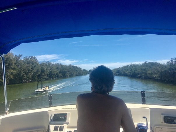
The Intracoastal and the St Johns intersect just west of the inlet at the Atlantic Ocean and Mayport, one of the largest naval stations in the United States and historic fishing village. As we veered west, Jacksonville came into view. It was impressive and intimidating. The river was wide and ships the length of skyscrapers filled the shorelines. I kept looking down, thinking I could “see” the tide. This river made the St Lucie look like a brook. In spite of the size of the river and the heavy industry, I kept noticing what appeared to be Monarch butterflies flying low across the water to the other side of the St Johns.“Unbelievable,” I thought. “How do they do that?”
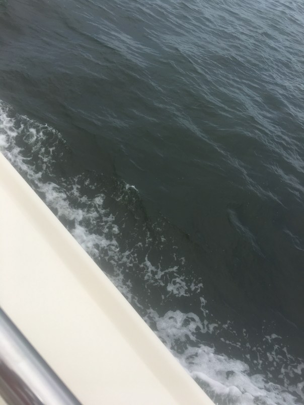
Everywhere I looked there were tugboats and container ships. A pod of dolphins joined our wake to say “hello.” Ed and I laughed and for a moment in time, nothing else existed. Just joy! “I can’t believe there are dolphins here!” Ed exclaimed.The dolphins finally pulled away and Ed shifted his eyes to the horizon. Our destination was an historic neighborhood, Ortega, about eight miles away located on the western bank of the St Johns River. Ed slowed down, called on the radio and little Ortega River Bridge slowly opened. The horn blew – a sound from a simpler past. “Thank you!” I waved from the bow and shortly thereafter we slid into a slip at the Ortega Marina.That evening we met Captain Paul, the Ortega Marina Dock Master, who became our guide, friend,  and confidant.  In the evenings he held court on his boat, “Passages,” telling stories of tides, time, and fishing tournaments.

The next morning Ed and I used the marina bicycles and rode throughout the historic district of Ortega. It was stunning! Oak trees and mansions the size of dinosaurs filled the landscape. Ortega got its start in 1769 so history includes many tales. I enjoyed seeing that Florida has many live oak trees that can compete with our northern neighbors. Breathtakingly beautiful trees, branches to the ground! Almost back at the marina, we visited nearby classic Chamblin Bookmine, Highway 17 – wonderful to browse for hours as most in Stuart are now long gone. After a final cool down and walk to Publix where we met displaced Canadian Geese searching for last year’s wetlands, Ed and I  visited again with Captian Paul. I informed him I had researched and found out the beautiful flowers growing in the Ortega Marina were swamp lilies;  we were already fast friends even though I was a “tree hugger.” Ed was looking to Paul as a mentor. Planning for tomorrow, we  talked tides and weather figuring out our departure.

Night fell. Ed and I slept like babies with the sound of the train echoing in the distance. I dreamt about Henry Flagler, riverboats, and Canadian Geese. I was excited about our next stop, September 8: Palatka.


Meeting up with Cinnamon Girl to Document the IRL

Friday night, August 6, 2021, Ed, Luna, Okee and I spent the night on Adrift, after meeting up with “Cinnamon Girl,” the craft of Dutch and Mary Radabaugh. Their name may ring a bell as Dutch and Mary were the face of Central Marine during the infamous toxic algae outbreaks of 2005, 2013, 2016 and 2018. Fortunately, there is no blue-green algae bloom  in the St Lucie/Indian River Lagoon today as they ACOE has not discharged from Lake Okeechobee since April 10, 2021 due to algae sitting at the gate of Port Mayaca.

As mentioned in my previous blog post, the rains have begun, rainy season is upon us, and although stormwater runoff and C-23/24 are tainting the river brown, it is remains beautiful and safe so Ed and I decided to take Mary and Dutch up on their offer to meet and anchor in the IRL near Boy Scout Island. We had done this two years ago. How time flies!

It turned out to be a wonderful weekend and we got to observe. The seagrasses were no where close to as thick as they were in 2019, but they were there, and and recovering.  Macroalgae coated everything. This is disappointing but is happening across the entire Indian River Lagoon due to nutrient conditions. Nonetheless, thankfully, at low tide the wading birds were abundant. We also saw manatees, sea turtles, stingrays, snook, hermit crabs, one large conch and hundreds of shiny minnows. I was impressed!  I think there is no more beautiful place that the Indian River Lagoon at sunrise or sunset. Glorious…

We must remain vigilant.

Lake Okeechobee reached 13.87 feet over the weekend, eyeonlakeo, thus the C-44 canal with its surrounding runoff will start flowing to the St Lucie once the lake achieves 14 feet. So is the operation of the Central and South Florida System. This will certainly affect the clarity of our waters. Thankfully there is still #NoLakeO.

I share these photographs to document and to celebrate a good year thus far in 2021. Let’s continue “Riverlution” to keep it that way!

-St Lucie River -headed southeast into Indian River Lagoon Indian River Lagoon. There’s Cinnamon Girl! -Ed with Luna going to say “hi!”-Dutch with Holly-Okee stays inside Adrift. She likes sitting on maps.-IRL at sunset, silvery. -After a peaceful night’s sleep under the stars, Okee awakes to watch a golden sunrise -Sun’s up! Time to paddleboard and check out the conditions. JTL, Mary, Dutch and Ed. -Ed takes a break-Water brownish from rain and canals C-23/24. Greenish in bright light. -Mangrove island in the area known as the Sandbar. Many birds roosting! Mostly ibis. -Bare bottom with a some seagrasses surrounding mangrove island and sandbar area. Mary noted in 2007 this area had very lush seagrasses that have since been destroyed by Lake O discharges. Today there are sprigs. -Water looking greenish in bright light -Ed checking out the conditions and happy as a clam-Macroalgae (below) coats everything ground and seagrasses- not good. Many believe this system is replacing seagrasses through out the IRL. Water quality is key to keeping seagrasses! After our journey out we return to Cinnamon Girl. There are visitors!-Nic Mader and I relax. Nic is a dolphin specialist.  Bottlenose dolphins like all creatures of the IRL are intricately connected to the seagrass habitat and the life that grows there.-Getting some exercise-Rains are beautiful falling in giant sheets from the sky! -Nic paddles towards home while looking for dolphins. 

-Mary Radabaugh is a very good photographer always carrying her camera. She captured these images. The roseate spoonbills and American egret were on the sandbar along many other wading birds. Wonderful to see! Watch the link below (in red) to watch a manatee video Mary took as well.

What a place of beauty. The St Lucie River/Indian River Lagoon  was once considered “the most bio-diverse estuary in North America.” Let’s continue to fight to regain that status! We are on our way back. Such a stunning, special place! Thank you for getting us on the ground out to see.  We love you Cinnamon Girl!

MANATEE SWIMMING IRL  IMG_0638

-Saturday afternoon, on our way back to the Harborage Marina in Stuart. Another memorable sunset…

Biting News at Peck’s Lake

Ed and I disagree on a number of things, but we are always in agreement about our pets! We had decided to take them with us for an overnight in the trawler at Peck’s Lake. 

I laughed and smiled. It was a beautiful and very cold day. I was so glad Ed had some time off. We were both having such a good time until I looked at the alert that came up on my phone…

“Ed you’re never going to believe this. There is an insurrection in Washington D.C.. A sea of Trump supporters are attempting to break into the Capitol.

It was January 6, 2021 and I knew for Ed this brought back terrible memories. In the 1960s Ed’s family had emigrated from Argentina to the United States to escape a series of military coups. 

Ed and I spoke for hours about the situation in the United States. Not much could be more depressing. Having Luna and Okee with us took off the edge. Before we all went to bed, Ed and I promised to get up tomorrow and enjoy Peck’s Lake. Peck’s Lake, as most all of us know, lies within the Jupiter Narrows and once was an inlet to the sea. Yes, historic maps show that many times the Atlantic has breeched this shoreline, most recently twice in the 1960s. The ACOE filled in this gap and today Nathaniel Reed Hobe Sound National Wildlife Refuge sits on these sands. You can reach this place by boat or a long walk north from Hobe Sound Beach in Martin County. If you like to canoe, you can put in at Cove Road. Peck’s Lake is one of 560 U. S. National Wildlife Refuges and lies in Martin County. Birds, mammals, reptiles, amphibians, and fish call this refuge home. 

A long walk along the beaches on the Atlantic side of the refuge is incredible, probably one of the only desolate beaches to be found on all of Florida’s east coast. Certainly, the area doesn’t look too different from 1696 when Jonathan Dickinson was escorted by the Ais Indians north.   Tooling around on the Jupiter Narrows side, Ed and I encountered wonderful things and weird things. We witnessed many osprey nests; we saw an otter surface and dive alongside an oyster covered mangrove forest, we also saw seagulls eating from a strange looking, large-eyed fish carcass. When I called Indian Riverkeepeeper, Mike Connor to find out what this cut-up was he said it was a swordfish! Ed and I threw the fish back into the water and seagulls dove for it from every direction.-Below: Osprey nest. Above: Ed drives dingy with trawler, Adrift in background at Peck’s Lake-Look! An otter! -Swordfish head floating. Very strange! -Seagulls dive   When Ed and I got home that evening, we also experienced no seeums or sand fleas and it was torture! 

“Are you getting bitten?” Ed asked coming into the cabin.

“Not really. Let me go outside and check.”

By the time I had been outside for thirty seconds, my hair was full of sand fleas and I was slapping and scratching myself everywhere at once. 

“Unbelievable! It’s been a long time since I felt them! When I was a kid growing up in Sewall’s Point and Stuart they were here!”

Ed and I ran inside and  barred the door as the tiny creatures made their way through anyway covering the lights of the cabin. Ed and I ate by flashlight that evening and Okee and Luna thought they were in heaven. Ed and I didn’t even think about the state of the world, we were too busy scratching…

Videos: 1. Cove, Peck’s Lake; 2. Mangrove Tour, Jupiter Narrows, Peck’s Lake

*Pets stayed on boat. They are not allowed in the wildlife refuge 🙂

*Thank you to my mother who shared to old add about sand fleas from First National Bank, forerunner of Seacoast. 


Tales of the Southern Loop, Key West to Cape Sable, Part 6

Tales of the Southern Loop, Stuart to Boyton, Part 1

Tales of the Southern Loop, Boyton to Miami, Part 2

Tales of the Southern Loop, Miami to Tavernier, Part 3

Tales of the Southern Loop, Tavernier to Marathon, Part 4    

Tales of the Southern Loop, Marathon to Key West, Part 5

Tales of the Southern Loop, Key West to Cape Sable, Part 6-Sunrise and setting moon, Key West

September 15, 2020

Before Ed and I left Key West, we were able to rid the trawler of the smell coming from the head’s sanitation system. It took three trips to West Marine, multiple pump-outs, flushing with extra water, enzyme cleaners, and most important, changing the vent filter. The whole situation made us much more careful and aware.

Excited to overcome yet another obstacle, Ed and I pulled away from a rooster crowing sunrise for what would be the most memorable leg of our trip, Key West to Cape Sable. This was unlike any other in that it was eight hours, alone, in wide Florida Bay for about 70 miles at 7 knots!

We saw pretty clouds, blue skies, turquoise-blue waters, bobbing seagulls, cormorants flying as fast as ducks, two pleasure crafts, one crab boat, and one shrimp trawler. But that was it, most of the time it was just Ed, me, and crab pots as far as the eye could see!

-Happy to be safe at seaAfter about an hour, the wind started picking up. I put on a life vest as the sea began to swell. I imagined that if I did fall in there would be no way to be rescued as I would quickly be carried off. My imagination started to roam. Staring out to the empty horizon, I started to think, about pirates…

-A shrimp boat in the Gulf of Mexico/Florida Bay off Key West“Ed what would happen if someone came up to the boat and asked us for all of our valuables.”

“It won’t happen.” Ed replied.

“How do you know?”I asked looking off into the wide distance.

“Because I’ve read.  Pirates don’t frequent these waters, and if they did, they wouldn’t be attracted to a boat like ours.”

“Why do you say that? We’d be perfect. We can’t speed away.”

“Don’t worry so much Jacqui.”

“Why shouldn’t I? 

“There’s nothing to worry about; plus I brought a gun.” Ed slowly replied. 

“A gun!” I exclaimed. “If we’re not going to get approached by pirates, why did you bring a gun?” 

“Just in case.”

“Holy —- Ed! That certainly doesn’t make me feel any better!”

I exhaled, trying to calm down. 

During the course of our conversation the swells got steadily larger, up to 5 feet coming from our stern, and off to the side, our beam. Adrift was dancing in the motion! 

“I didn’t know waves in Florida Bay could be so big. I exclaimed. “Why didn’t you tell me?” 

“Jacqui, come on,  it’s part of the Gulf of Mexico.” Ed peered through binoculars.“What are you looking for? Pirates?”

“No, just looking.” Ed replied. 

“Ed, I’m not feeling so good. These waves. This is crazy.”

“Do you want me to turn around?” He asked, getting irritated. 

“No.” I conceded. “Since we’ve been out here this long, we might as well go the whole way.” 

The trawler hit hard against the ocean, fear got the best of me and I wondered if the boat might eventually break into pieces. 

“Could this thing start coming apart?  I inquired, holding my hand over my mouth. Metal creaked and the hull hit relentlessly. With each strike I daydreamed of balancing on a piece of the crushed hull in my bright yellow life vest of course surrounded by sharks.

“I don’t think so,” replied Ed. 

“I’m going down; I think I’m going to be sick.”

“Holding on for dear life, I stumbled down the stairs from the upper helm to the stern. 

“Oh no,” I thought to myself, “I don’t feel good at all.” I walked into the cabin and then into the head, sat down on the toilet, and  suddenly projectile vomited. It was bright red as I had been drinking tropical punch Gatorade and raspberry yogurt. I stared in disbelief.  I felt terrible. The exaggerated wave motion was even more pronounced in the cabin. I held on for dear life.

 “This is unbelievable; this is no fun!” I got myself together, stumbled through the cabin hitting walls. With one arm always holding on to something,  I grabbed a hand towel, wiped my face, and struggled up the stairs to the upper upper helm.

And there I saw him. Ed was in his element! Loving it! Like a cowboy on a wild mustang. I sat myself down, holding on to a metal post that was creeping like a Halloween set. I looked up: “Ed, “I puked.”

“I figured as much. Feel better? “

“Oh no! It’s happening again!” Adrift sunk deep into a wave then popped back up. I leaned over, and let go. Ruminants of tropical punch Gatorade and yogurt splattered everywhere. This was not good. I was embarrassed. 

Ed softened. “Babe lay down; I’ll clean it up  later. It will be less bouncy up here.” Ed and I had been through such exercises many times as I had thrown up in the plane over the years when flying over Lake Okeechobee to take pictures of harmful algae blooms. 

I put my head down on the cushion but no matter how hard I tried, I could not rest. The seas tossed and slowed our progress. 

I raised my head. “How much longer?”

” A couple hours….” I lay down again praying for it to be over. 

As I lie in agony, I asked the same questing multiple times – about two hours apart: “How much longer?” Ed’s answer was always the same. “Two hours.” I eventually realized that if that were true, we would have already been there! This was the most extended motion sickness episode of the many I had had in my life. I couldn’t wait for it to be over. 

Eventually, the waters started to calm down and our destination, Cape Sable, came into to focus before us. As always, as soon as I was on stable ground, I felt better. My spirts rose, we easily dropped anchor, and planned an excursion. Looking towards the untouched shoreline was incredible! 

“This must be what Ponce de Leon felt like.” I said beaming.

-Map 1859

“Hey, isn’t this where that little tongue-twister of a bird is originally from?” Ed asked.

“Good job Ed! Yes!”  The endangered and controversial Cape Sable Seaside Sparrow! It was the changes and destruction brought to its habitat from the 1935 Labor Day Hurricane, and Hurricane Donna in 1960, that caused it to adapt further up the Florida peninsula-where the Central & South Florida Plan had drained the Everglades. Unfortunately the little bird chose to live just south of Tamiami Trail where we now want to move more water south.” 

“I wonder who will win that one?”  Ed joked. “The Endangered Species Act is sacred for you environmentalists.”  Like young kids, Ed and I explored a dying mangrove forest, endless shells, flora, and wildlife around Ingraham Lake. Just north-interior lie famous Whitewater Bay and Shark River Slough, all within dingy distance. A veritable eco-playground! 

I found the sands most beautiful, crushed shells from millions of years all mixed together. This makes sense as Cape Sable is the southernmost point in the United States, all left to flow, flows here. Thankfully it lies protected within Everglades National Park. And thought humankind and Climate Shifts are rapidly changing its nature, Cape Sable remains absolutely stunning  in its timeless and weathered beauty.

-Cape Sable, Everglades National Park-Taking the dingy to Cape Sable’s  shore. Ed wondered why the water was so murky. “It’s an estuary!”  Water coming from Shark River Slough into Florida Bay.-Adrift at her destination, Cape Sable-On the desolate beach, Cape Sable-Shells, and ancient Inidan midden remains -Dead and dying but strikingly beautiful mangroves like art from many hurricanes -Land snails -Many shells were pierced and attached to the weathered mangroves  -On the other side of this marsh lies Lake IngrahamThe whole experience was otherworldly- as if Ed and I were the only people in the world! As the sun set we made dinner and drank wine – watching the stars appear one by one until the entire Milky Way shone above us like a glistening blanket. Just incredible! We sat in the upper helm and discussed philosophy like we were students of Plato or Galileo. I had no memory of my motion sickness earlier in the day…

A gentle breeze blew, Ed held me under the stars…

“I love you.” I said softly into to his ear…

And then I continued…

“but I might as well tell you right now, you’ll be sleeping with the gun, by the door, in the cabin tonight, just in case the pirates do arrive.” 🙂“Sea you next time! Cape Sable to Marco Island!” 🙂


Tales of the Southern Loop, Boyton to Miami, Part 2

Tales of the Southern Loop, Stuart to Boyton, Part 1

Tales of the Southern Loop, Boyton to Miami, Part 2

It was September 4th, early morning, we’d  had our first cup of coffee, the engine was yawning, and Ed was at the helm. Today was part two, Boyton to Miami…

“You know what to do right?” Ed jokingly mocked from the helm. He was way too chipper.

I rubbed my eyes. “Yes Captain.”

There wasn’t much wind or tide; I easily removed the spring, bow, and stern lines in that order.

ADRIFT inched off the dock.

“Good job mate.” Ed yelled.

“It’s easy on a day like today!” I replied, knowing the entire Southern Loop adventure would not be so easy.

It was an absolutely beautiful morning. Ed made the radio request on Channel 9 to open Boyton’s Ocean Bridge; we waited, and as the draw raised up the trawler slid into the long man-made cut of the Intercostal Waterway.

The scene was almost surreal, especially the reflections; the water itself did not look great -trapped inside seawalls, houses, and lawns gushing fertilizer.

Ed yelled,” Look at the man cutting the mangroves!”

I turned to see a worker balancing  atop rocks holding  a trimmer over his head.

“Unbelievable!” I sarcastically yelled back. “You’ve got to love South Florida!”

The sun shone hotter and hotter.  We passed Delray Beach, Highland Beach, Boca Raton, Deerfield Beach, Hillsboro Beach, and Lighthouse Point.

“Hey Ed,”Hillsboro Inlet and lighthouse is coming up. The pre-drainage Hillsboro River was about the north mark of the historic east coast seepage of the Everglades!”

I was referring to my new favorite book, Landscapes and Hydrology of the Predrainage Everglades.

As we slowly made our way, I saw finger canals everywhere…

Construction to channelize the Hillsboro River and the Miami River had first begun in 1910. The New River, in 1906. It wasn’t just the most southern coastline that was wet either, apparently the region from the Jupiter Inlet to the Hillsboro Inlet was once so marshy people canoed between the two- and out into the Everglades- regularly. That was until drainage lowered the water table six feet! Crazy isn’t it!

“Everglades eastern flow was directed towards numerous natural outlets piercing the Atlantic Coastal Ridge, specifically Cypress Creek, (region of Hillsboro River JTL) Middle River, New River, Snake River, Arch Creek, Little River, and the Miami River.” These flows eventually made it to the Atlantic Ocean and  Biscayne Bay.” Pg 262, Landscapes & Hydrology of the Predrainage Everglades, 2011. 

It is strange to think that there are no natural flows through these once cypress forests and rivers, but rather a channelized construction of canals, pumps, and structures kept in place by the South Florida Water Management District.

We forget that the Everglades’ waters, beginning in Lake Okeechobee, once seeped through, on and off, around today’s Pompano Beach; Ft Lauderdale to Miami; and even at South Miami to about Leisure City. Today ADRIFT would only make it to Miami.

  1. 1850s undeveloped South Florida: Cypress Strands, the Peat Transverse Glades; and the Marl Transverse Glades were once natural seepage areas from the Everglades. Landscapes and Hydrology of the Predrainage Everglades pgs. 49, 48, & 266. Notice how canals were constructed to these natural outlets. (3)

2. Modern satellite image of of S. Florida, note areas that once flowed through near Pompano (Cypress Strands); Ft Lauderdale area (Peat Transverse Glades); and further south of Miami (Marl Transverse Glades). Compare image 1 &2.

3.  Earliest canals New River to Ft Lauderdale 1906; Hillsboro & Miami 1910. (Boyton for reference.) These canals led to where the water was naturally exiting the east coast.

“Hey First Mate!”

“Captain!”

“Get your head our of that book and look around!”

“Holy cow!” I screamed. It looked like we were going to be swallowed up by the wake of a cargo ship!


4. Near Ft Lauderdale’s Port Everglades

5. Condos along the ICW near Ft Lauderdale

6. North area of Biscayne Bay, Broad Causeway Drawbridge at Bay Harbor

I was speechless. We had entered Ft Lauderdale. The modern Transverse Peat Glades! I watched in total amazement.

“Come up on to the helm,” Ed yelled. “We’re in Biscayne Bay almost to Miami.”

I put my book aside and crawled up the ladder. Even though I despise over development , it was very exciting. Huge ships went by and multi million dollar boats were docked everywhere.

“I think this is near the area of  the recent fish kill.” I said. I showed Ed my phone pointing to the area between Highway 934 and 1-95. “The bay has polluted stormwater runoff problems and also it doesn’t get all the fresh water it historically received because we have cut off its flow connection of the cypress, peat and marl transverse glades.”

Ed looked at me through his sunglasses. “You read too much. Just enjoy!”

7. Further south in Biscayne Bay

8. Port of Miami

9. Ed smiling

10. Miami shoreline near Miami River/Maimi Canal outlet

11. Some wildlife! Yeah! Cormorants!

“Wow. This is amazing I said. My book was put away under the cushions.

“Where are we going to park? Make sure we don’t damage any seagrass.”

Ed rolled his eyes. “Not “park,” “anchor!”

We made our way just southeast of the Magic City and Rickenbacker Causeway. Remarkably, we anchored without a blip on a sandy/muddy bottom.

ADRIFT relaxed and found her direction in the tropical breezes. The whole thing was rather otherworldly. “God I love South Florida,” I thought,” even with all its water and drainage issues, she’s beautiful!”

12. A homemade dinner on the ship!

13. The Magic City arises…as night falls.

Tales of the Southern Loop, Stuart to Boyton, Part 1

Tales of the Southern Loop, Stuart to Boyton, Part 1

It was 9:36 am, September 3, 2020, and we were preparing to leave the Harborage Marina in our hometown of Stuart. The sun blazed down upon me as I  stood on the bow of the Mainship 400 trawler we had christened ADRIFT. The day had arrived. Ed and I were off -for three weeks- to experience our first real boating adventure- the Southern Loop. 

Ed yelled down from the helm. “So you know what to do, right?”

“Of course Captain!” I reviewed: 1. Check wind and tide direction. 2. Release the stern spring line. 3. Release the the bow spring line. 4. Release the bow line. 5. Release the stern line. 6. Make sure boat is clearing the dock. 7. Relay message to Captain. 

“Aye, Aye, Captain!” I yelled back over the sound of the diesel engine. Then just to tease him, I asked: “Is it the front, or back spring line first?”

Ed did not smile…the motor growled, I moved starboard, quickly, carefully, and methodically removing some lines from their cleats and bringing others on board.

The trawler inched forward like a sputtering whale. 

“You’re clear!” I yelled, watching the transom just miss the dock piling.  

We slowly motored out against the tide, and our adventure had begun. I walked to the bow looking over the wide and beautiful St Lucie. The trip through the St Lucie, the Jupiter Narrows, the Loxahatchee, Lake Worth, and the canal-like portion of the Intercostal Waterway to Boyton would be familiar, but from there it was all new territory.

  1. St Lucie/Indian River Lagoon looking towards St Luice Inlet

2. Jupiter Narrows entering Loxahatchee and Jupiter Inlet area

3. Jupiter Lighthouse first lit in 1860, Loxahatchee River

4. Channelized ICW from Loxahatchee River in Jupiter south to Lake Worth

5. Lake Worth

6. Port of Palm Beach just west of Peanut Island and inlet

7. Lake Worth, the Alba Hotel, built in 1926, is today’s Biltmore Condominium 

Ed, and I planned for our Southern Loop adventure for over a year. We took hands-on classes. We altered our schedules. We read books. Most important, we promised not to kill each other. 

This blog series is meant to share our adventure and learn about our South Florida  waterways with the help of an incredible book I read along the way, Landscapes and Hydrology of the Predrainage Everglades, written by five South Florida Water Management District scientists, led by Christopher McCoy. 

By the time we arrived at Boyton Harbor Marina the sun was setting. It was time to have a cocktail at a classic establishment, the Banana Boat or TWO GEORGES, historically Lyman’s Commercial Fishing Dock, now part of the Community Redevelopment Area. 

A moist breeze filled the air. Ed inquired. “What’s our water lesson today?”

I took a deep swig of my daiquiri, “Well something new I learned is that there used to be a chain of ponds just west of here. Extensive. 20 miles of them! 2 miles wide…

Boyton sits not too far below Lake Worth in Palm Beach County. Chris McVoy’s book notes that in this area, not only was Lake Worth opened up to the ocean, and the gigantic arm of the Loxahatchee Slough -once connected with the Everglades- swallowed up by development, but  there was a  twenty mile chain of freshwater ponds – also described as a sawgrass marsh- just west of here, and now it’s the area of Congress Boulevard!”

“Really,” replied Ed. He took a swig of his beer. We drained the swamp right?”

My brain was frozen. “Sometimes I wish we didn’t. Not so much anyway…”

The two images above are from Landscapes and Hydrology of the Predrainage Everglades and compare the area from the Loxahatchee to the Freshwater Ponds east of the Northern Everglades from 1850 to present. The contrasting images reveal many aspects of the environment that we don’t think about today. Going clockwise from noon. The connection of the C-44 to the St Lucie River; the channelization for the ICW along Florida’s east coast; the cutting of pine and cypress forests; the “disappearance” of the Loxahatchee Slough’s giant red arm up from the Everglades and across Palm Beach County to the Loxahatchee River in Jupiter; the replacement of the sawgrass plains with the Everglades Agricultural Area; the man-made inlets and the opening to the ocean of Lake Worth; and last but not least, the very rarely talked about chain of freshwater ponds that that have been drained and are now the area of Congress Boulvard. All of the drainage allows us to live here and helped agriculture in the past; however we have impaired our waters. Images, pages 48 &49, Landscapes and Hydrology of the Predrainage Everglades, SFWMD, Christopher McVoy and others, 2011. 

Red lines equal pre-drainage boarder of the Everglades; yellow lines equal pre-drainage landscape boundaries: primarily sawgrass plains and Ridge and Slough with visible tree islands of which east coast development has heavily encroached. You can see the WCA (water conservation areas) along eastern Atlantic Ridge. You can recognize this because they are the only areas with ridge and slough water pattern remaining. These areas, although protected, are now water impoundments since the ACOE built the Central and South Florida Project after the 1947 flood. Tomorrow, we will learn how the Everglades’ waters once exited to the Atlantic Ocean right through parts of Florida’s east coast when we continue our trip from Boyton to Biscayne Bay/Miami! 


Adrift’s Indian River Lagoon Water Report, June-July 2019

July 5, 2019

Hi. I hope everyone had a wonderful 4th of July! Wasn’t it exceptional? Exceptional because the St Lucie/IRL’s water wasn’t toxic like so many times in recent years. So nice to be able to enjoy our waterways. No dumping of Lake O. I am grateful!

Today I am a back with an Indian River Lagoon Report for the entire Indian River Lagoon.

During my husband, Ed, and my recent 156 miles trip up the IRL, aboard ADRIFT, I contacted Duane DeFreese Ph.D., Executive Director for the Indian River Lagoon National Estuary Program. I called Duane because I knew why the southern lagoon looked better but was impressed by how good the water in the central and northern lagoon looked as well. No brown tide. No superbloom.

Since am unfamiliar with the waters north of the Treasure Coast, except by books, I wanted a scientific update. Well, boy, did I get it! See Dr. Duane’s comments below. Also included is the invaluable, recent St John’s Water Management District’s “June 20th Indian River Lagoon Conditions Update.”

For visual input as well, I am inserting some of Ed and my photos, with comments, of our incredible journey along what is still considered to be one of the world’s most biodiverse estuaries. What a treasure! From north to south, we must do all we can to ensure a toxic-free future.

Keep up the fight!

Jacqui

IRL map: Researchgate

Ed and JTL start of the trip on “Adrift.”

Location: Jupiter Island near the Jupiter Inlet, as almost always the water here is like the Bahamas, looking great! Near the border of Martin and Palm Beach Counties.

Near Jupiter Inlet, border of Martin and Palm Beach Counties. Wow!

JTL:

Duane, hi. Hope you are having a great summer. At this time, are there algae blooms reported in the IRL near Melbourne, the N. IRL north of Titusville, or anywhere in the Mosquito Lagoon? Thank you for letting me know. Jacqui TL

Duane DeFreese, Ph.D. Exec. Dir National IRL Estuary Program, http://www.irlcouncil.com

Conditions being reported to me by the local guides are consistent with the report and my own observations. Overall water quality looks pretty good, but small, patchy areas of poor water quality continue. The fishing guides tell me one day it looks great and a day later the same area will have color and turbidity (probably patchy bloom conditions). My personal observation is that we have been lucky so far and the system is vulnerable. I would not be surprised to see blooms intensify as we move deeper into summer and the rainy season. Lagoon water temperatures are also really warm. the SJRWMD Report documents that we have had patchy blooms occurring of multiple species. Two confirmed species of concern are Pseudo-nitzschia, a marine diatom and Pyrodinium bahamensis, a dinoflagellate. The worst water conditions continue to be in Banana River and in Sykes Creek. There are boater reports of patchy poor water quality in some areas of the northern IRL. The third species of significant recent concern has been Brown tide (Aureoumbra lagunendis). It was in almost in continuous bloom for most of last year in the Banana River. Bloom conditions have subsided. Aureoumbra thrives in warm, high salinity environments. It is not known to be toxic. Blooms of pseudo nitzschia, a marine diatom, can produce a neurotoxin called domoic acid. Blooms of Pyrodinium can produce saxitoxin. I expect that we will see patchy and flashy bloom conditions of multiple species throughout the summer. If we get lucky, I hope none of these blooms get intense enough to elevate toxin levels, low DO levels and fish kills. I’m very concerned about the slow recovery of seagrasses, even in areas of good water quality. Feel free to call me anytime.  Have a great 4th July!

Indian River Lagoon Conditions Update June 20

JTL:

Dear Duane, thank you so very much for the super informative reply! I wrote because my husband and I are taking our maiden voyage in a trawler. We have gone from Stuart to Jupiter to Vero to Cocoa, north as far as possible in IRL, past Titusville, and today-through the Haul-over Canal into the Mosquito Lagoon. Not being familiar with these waters, all I have seen visually appears quite good compared to the St Lucie and even parts of the S. IRL. Some varying coloration is apparent, but overall seems good and in the north, many baitfish balls are shimmering under the surface and dolphin families are gorging themselves and teaching their young! We have seen many dolphins everywhere. Throughout Indin River County, Ospreys nesting in channel markers. One after the other!  In the Mosquito Lagoon there were many more wading birds than S IRL. Even saw a few roseate spoonbills. I was not expecting it to be so full of life up here… a nice surprise. Not off the chart healthy, but marine and bird life very visible! I really appreciate the info you sent. I plan to blog on trip once home, so I can quote your knowledge. Happy 4th of July to you as well and I hope to see you soon.


The confluence of the St Lucie River and Indian River Lagoon off S. Sewall’s Point, Bird Island. Near Stuart, Martin County.

Sewall’s Point and Stuart, Martin County.

Beautiful blue water near the Ft Pierce Inlet, St Lucie County. Ft Pierce rocks!

Waters of Vero Beach, Indian River County.

Old map showing the designated area of famous INDIAN RIVER LAGOON CITRUS. Citrus Museum, Vero Beach, FL

1920 Blue Heron Map shows clearly the area of the Everglades, Heritage Center and Citrus Museum, Vero.

Street sign in Vero Beach, as everywhere ALL canals lead to Lagoon! No trash, fertilizer, pesticides, etc!

Sebastian Inlet, Indian River County, brings blue waters to the area. So pretty!

Approaching Cocoa Village, north of Melbourne in Brevard County.

Waters nearing Cocoa Village in Brevard County

Ed and I visited the Kennedy Space Center along the Indian River Lagoon and Banana River. Surrounded by the Merritt Island National Wildlife Refuge. Space & Nature. https://www.fws.gov/refuge/Merritt_Island/visit/plan_your_visit.html Such an inspiration!

3-D movie at Kennedy Space Center really took us to the moon, Mars, and beyond!

The ominous Vehicle Assemble Building, NASA, so large it is visible no matter where one is are along the central and northern IRL. It’s like it is following you!

Eau Gallie, Melbourne. The Eau Gallie River, or Turkey Creek,  is a small version of the St Lucie and also impaired due to runoff from agriculture and development.

Like a sentinel, the Vehicle Assembly Building as seen over the Indian River Lagoon north of Titusville.

Baitfish!

Waters approaching Titusville, Brevard County.

Train track bridge north of Titusville, Brevard County.

Train track bridge north of Titusville, Brevard County. Shortly beyond channel turns right through the Haulover Canal and into the Mosquito Lagoon.

Ed navigates through the Haulover Canal, connecting the northern IRL with the Mosquito Lagoon.

Water in the Haulover Canal was greenish.

Entering the stunningly beautiful, peaceful, undeveloped Mosquito Lagoon. This area is flanked by the Scottsmoor Flatwoods Sanctuary and Canaveral National Seashore. Wildlife abounds.

360 of the unforgettable Mosquito Lagoon:

Flora and fauna along shoreline, Mosquito Lagoon

Anhinga twins, Mosquito Lagoon

Incredible footage of 4 dolphins in our wake near Ft Pierce welcoming us home!

ADRIFT is a 2007 Mainship 400 trawler, top speed about 8 knots 🙂