Ed’s comment when he came home from flight yesterday was “not as bad as last time.”
Today’s aerials were taken 8-6-23 around 1:30pm. One can see blue-green algae, along the eastern shoreline of Lake Okeechobee, but not as much in the C-44 canal.
The St. Lucie River looks a bluer near Sewall’s Point- perhaps thanks to recent full moon tides and less rain runoff. Seagrass meadows covered in increasing a cyanobacteria and macro algae are visible. The seagrass is returning, but not in as good a shape, after massive and longterm Lake O discharges in 2018, 2016, and 2013 and decades of destruction.
Sandbar near St. Lucie Inlet, 8-28-23, FB Mike Yustin
Ed and I continue to be your “eye in the sky” and Todd is helping all of us keep an eyeonlakeo now at 15.30 feet according to the SFWMD. Hurricane season should start ramping up. It is not a good situation. More water should be able to be sent south as God intended.
~Lake O, Rim Canal, and C-44 at Port Mayaca’s S-308
~St. Lucie River-Indian River Lagoon. Sewall’s Point divides these waters.
~Note seagrass beds in next two photos. Once 700 acres now much less and impaired. Good to see it in any case!
Thanks Ed!Canal system of CSFP SLR/IRL. credit SFWMD
“Jacqui, there is a beautiful linear park containing a diverse sample of trees similar to what was in the historic Barley Barber Swamp: the Lake Okeechobee Ridge Park. The park is the last remnant of the original shoreline of Lake Okeechobee. The Rafael E. Sanchez Memorial Trail runs throughout the length of the park and is a part of both the Big Water Heritage Trail and the Great Florida Birding Trail. The trail runs along the original sand/muck berm that was constructed along portions of Lake Okeechobee before the 1926 and 1928 hurricanes washed them out. Access is along US41 just north of the St Lucie Canal.”
The park in Port Mayaca, Martin County – next to Indiantown, is open from dawn ’til dusk, so yesterday afternoon, Luna and I went for a walk in the Rafael E. Sanchez Memorial Trail that Gary told us about. It was fascinating!
The skinny forest was stunning and even with the modern noise from the old Connors Highway ringing in my ears, it took me back about a hundred years. As I walked, I thought: “The park is the last remnant of the original shoreline of Lake Okeechobee; the trail runs along the original sand/muck berm that was constructed along portions of Lake Okeechobee before the 1926 and 1928 hurricanes washed them out…”
Soon after 1928, the state and federal governments’ answer materialized into the Herbert Hoover Dike, -forever altering the living-lake, shrinking it and blocking it from expanding.
Lake Okeechobee, SFWMD
Today I share Luna and my walk through this amazing remnant forest. Once periodically flooded, now dry, Luna and I saw only a few very tall and beautiful cypress trees. But we could imagine the old shoreline full of them with their knees pushing forth from the earth. Luna and I also saw massive strangler-figs and oaks and even the famous white moonvine that once graced the pond apple forest south and east along the lake. Luna and I also saw many cabbage palms. The leaning/curving palms, seeking light, were really beautiful. Certainly a hundred years ago the flora and fauna was very different, but Luna and I did get a “glimpse” and for that I am thankful.
For perspective, the FPL cooling pond lies to the east. The park goes on for six miles well beyond my image below. I hope you’ll check it out! Thank you Gary for your comment and for expanding my knowledge of the once great forests of Indiantown.
FPL cooling pond/ Barley Barber Swamp are located to the east of the linear park.Luna walking amongst leaning cabbage palms, giant strangler-figs, cypress and oaks. Dogs are allowed on a leash.
Luna walking amongst leaning cabbage palms, giant strangler figs, cypress and oaks. Dogs are allowed on a leash.
mixture of trees
many huge strangler figs
A tall cypress tree-maybe some relation to the Barley Barber Swamp?!
the old sand/muck berm
Bridge Conners Hwy. at Port Mayaca
Entrance to park
A tall cypress tree-maybe some relation to the Barley Barber Swamp?!
Who was Rafael E. Sanchez who must have inspired this wonderful park?
Palm Beach Daily News, October 6, 1994.1855 vs 2023 Todd Thurlow. The beginning of the park can be seen in southwest corner.
Today’s post is the second part of a story. A story from the 196450th Anniversary Edition of the Stuart News. “Signalizing Half a Century of Growth and Progress in Martin County,Florida.” It is a huge special edition newspaper, 110 pages!
The article I am sharing is on page 6-H and is titled ” St. Lucie Canal Approved in 1914, Is Boon to Agriculture Here. Huge Citrus Growth Along Water Route; Mayaca Groves First.” I feel this remarkable article given to my mother for her history archives by family friend and real estate man, Ronnie Nelson, must be shared. As the 100 year “anniversary”of the St. Luice Canal is next year in 2024. At this time, I must state I am finding many different dates as to the completion date of the canal, but at this point I am sticking with an article from the Department of Environmental Protection, 1916-1924. (Ecosummary 2001, C-44 Canal)
Learning about the St. Lucie Canal can be confusing because it was “rebuilt” or “improved” and, believe it or not, “celebrated” a few times. I think this article included in the 50th anniversary edition was written as the canal approached its second rebirth in 1937.
There is so much to learn about how the St. Lucie Canal was perceived in earlier times. And it is only through understanding the past, that we can create a better water future for today and for tomorrow.
1964 Stuart News, 50th Anniversary Issue, Thurlow Archives1964, Stuart News 6-H and 7-H
Transcription begins:
“The completion of this monster ditch will mean much for the Everglades, for south Florida in general, and for Stuart in particular. The improvement of the St. Lucie Inlet and harbor will thus make Stuart the gateway to the Everglades, and millions of dollars worth of agricultural timber, fish, and livestock products will pass through the canal transferring at Stuart onto ocean-going vessels. The canal is, according to contract, to be completed in four years.
First tangible result of the canal for large-scale agriculture was the pioneering effort of the Port Mayaca development back around 1925, created by Bessemer Properties, Inc., a Phipps company which saw the opportunities for agriculture through scientific water control by tapping on to St. Lucie Canal with pumps to provide irrigation in dry spells. At the same time, a series of canals discharged excess water into the canal during wet spells.
Port Mayaca Valencia orange groves today represents the first big-scale successful planting of citrus in Martin County.
Port Mayaca could well be said to be the test plot on which millions were spent to prove, by trial and error, with the best possible scientific agricultural advice, what could be done by enlisting the aid of the man-made waterway.
Paul M. Hoenshel, now a resident of Stuart, was the first agricultural manager in the Port Mayaca development. He was backed by the vision and guidance of such able Phipp’s representatives in Florida as Paul R. Scott and Roy M Hawkins, as was Thomas Gartland when he took over the management in later years.
Port Mayaca was an outstanding “first” because it squarely faced up to the fact that the problems of drainage and water control must be solved if agriculture was to be successful in Martin County. The Phipps interests took the property of several thousand acres and divided it into forty-acre fields separated by drainage ditches, roads, and windbreaks.
About 100 miles of those ditches were dug in the Port Mayaca development, all linked by giant pumps to the life saving waters of the canal. Since Port Mayaca contained both muck lands and sand lands, it was an ideal test tube not only for for its initial 600 acres of Valencia oranges but also for various truck crops, gladiolus- then a major flower crop before chrysanthemums came along- and for experiments in the right grasses and mineral additives to make pasture lands where livestock could thrive…”
~End of transcription. To be continued. JTL
Google Maps 2023 shows Port Mayaca’s location on/near Lake Okeechobee, in Martin County, FL. Blue Dot is area of confluence of St Lucie River/Indian River Lagoon leading to St Lucie Inlet.
Documenting the Discharges, Saturday, April 3, 2021.
Since last week, the ACOE has lowered discharges to the St Lucie River from 500 cubic feet per second to 300. The lake is now down to 14.44 feet from over 16. Blue-green algae has been spotted in the C-44 canal near S-80 at St Lucie Locks and Dam. This canal connects Lake O to the St Lucie River and blue-green algae is always of concern as reported my Max Chesnes of TCPalm. Ed and I saw no algae at S-308 on Lake Okeechobee from the air. The water does have an odd hue-perhaps due to wind. We did not get over S-80 due to weather conditions.
This go around, the ACOE began discharging on March 6, 2021 to the St Lucie River, so yesterday, when these photos were taken it was 28 days after the discharges. The aerials were taken from about 3000 feet, at approximately 3:30pm, on an outgoing tide. Conditions were windy, cloudy, and all waters were stirred-up.
Please note federal, state, and local links on subject following photographs.
~Wishing all a Happy Easter and Spring time! See you next week. Ed & I will continue to document the discharges.
J&E
Running images of S-308 at Port Mayaca, Lake Okeechobee and over the St Lucie River/Indian River Lagoon near Sewall’s Point the dividing peninsula of these waters-merging at the Crossroads and Sailfish Flats near the St Lucie Inlet. Photos Ed Lippisch.
SFWMD canal and basin map. C-44 canal is the canal most southerly in the image connected to Lake Okeechobee. Note S-308 at Lake O and S-80 at St Lucie Locks and Dam.
Keeping up the Lake Okeechobee algae bloom documentation, Ed and I flew from Stuart to Lake Okeechobee during a hazy, hot high-noon, on Sunday, July 5, 2020. The algae was much toned down from our previous flights in June. Nonetheless, one could see the pattern, the outline, of the giant bloom from above. Rain may have disrupted its perk but the bloom remains in the water column. The most visual appeared to be in the middle of the lake and again, about a mile or so off Port Mayaca.
I have included photographs of the journey: St Lucie River at Palm City; flying over western lands and under construction C-44 Reservoir/STA ; FPL cooling pond; algae in Lake O; Clewiston; south rim of lake with agriculture and sugar fields; Indiantown and Hwy. 710; DuPuis and Corbett Wildlife Areas; one glance back to Lake Okeechobee; and an updated 2020 “Covid-19 portrait” of Ed and me.
We will continue to document throughout the summer. Keep up the fight! Stop the Discharges! Stop the Algae!
~Your eye in the sky
Jacqui & Ed
St Lucie River at Palm CityWestern lands and C-44 Reservoir/STA under construction-5 STA cells filledFPL cooling pond and edge of LOAlgae in LO off Port MayacaCloser to center of LO
ClewistonSouthern shoreline and agriculture fields, mostly sugarcaneSoutheastern shorelinePort Mayaca, DuPuis, Corbett Wildlife Management Area-dark green
This shot, below, was taken flying back east over the Village of Indiantown. Highway 710 is seen bisecting neighboring Dupuis and Corbett Wildlife Area and John and Mariana Jones Hungryland Wildlife Area. I will be writing more about the protected areas and the highway that cuts through them in the future.
“Hey get rid of that plastic water bottle would ya? 100 degrees or not!” Jacqui & Ed 2020
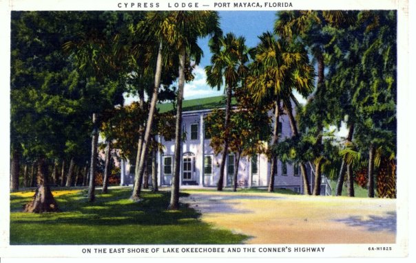
Historic Postcard courtesy of historian Sandra Henderson Thurlow.
Back of post card
If one drives to end of Kanner Highway adjacent to the C-44 Canal connecting the St Lucie River to Lake Okeechobee, there is a gem to see. A place that will take you back to an earlier time. The name of this place is the “Cypress Lodge,” in Port Mayaca.
According the “History of Martin County,” this beautiful lodge first opened its doors in 1938 and is *now operated by Mr and Mrs Charles Dorrell functioning as a resting stop for tired motorist crossing the state from north to south, or east to west.”
Page 253 reads: “The lodge, boasting an outstanding cellar, is colonial in design, built originally as a tavern, has been operating ever since. The two-story all cypress building with a large dining room, is staffed mostly by residents of Pahokee, Canal Point, and surrounding towns. It is said more people work in Port Mayaca than live there.”
Just last week I learned that friend, and long time Stuart resident, Elsie Jean Stewart, has deep ties to the property as her parents were married there. She recently shared with me a wonderful family photo of the young couple. Their tremendous smiles in black in white were full of color. What days these must have been…
I recently drove out past the lodge on my way to Belle Glade while daydreaming what the area was like as in the mid-1800s between Seminole Wars. I saw a giant cypress forest full of wildlife and there was no dike around the lake, so from horseback, I could see over the wide expanse of Lake Okeechobee….
Those things are gone and the lodge was built later, but it is still connected. I have been curious to see the structure as I have been missing it on my recent drives to Belle Glade. On my last trip, I figured out that at some point the historic Connors’ Highway had been rerouted so now at the Lake, one must turn north rather than south to see the familiar structure.
When I found the lodge, I took some photos to share. Still beautiful. Still timeless. I believe today it is a private residence. Thankfully it is still here and remains a gem of Martin County’s fascinating history around Lake Okeechobee.
The Cypress Lodge and Port Mayaca are located west near S-308 at Lake Okeechobee. You can see the C-44’s connection from the Lake to the South Fork of the St Lucie River/Indian River Lagoon.
2-18-17: Correction!
Today I figured out, thanks to an article by the Luckhardts, that although not mentioned in the “History of Martin County” on page 252-3 , it was Paul M. Hoenshel of Miami who originally built and operated the lodge. Hoenshel is the grandfather of Elsie Jean Stewart whose “parents were married in the lodge” that I mention…. Jacqui
Radar weather screen shot from 4-29-15. My phone, NOAA site. JTL.
The past two days, I feel like I have been a guest on the TV series “Storm Chasers,” except I have been running from the storms.
Yesterday, I decided I really needed to go look at Lake Okeechobee myself to see the toxic algae bloom that has been reported through social media, TC Palm, and the internet. –The algae bloom that inspired Senator Negron to ask Col. Dodd of the ACOE to refrain from opening the gates, which they did not do. On Tuesday’s, at 2:00 PM, are the Army Corp of Engineers’ “Periodic Scientist Call for Lake Okeechobee” of which I have participated in for almost three years…
“Perfect,” I thought, “I’ll go to the lake for the call a bit early and take some photos. I will be out in Palm City around that time anyway; it’s really not that far…” The drive is about 20 miles.
Signs at Port Mayaca, Indiantown.JTL
In spite of the previous day’s inclement weather, I had not checked the weather closely as I can never figure out how to get radar maps on my phone. Not checking the weather, turned out to be a big mistake.
Satellite photo of Lake O, NOAA. If you look closely, you can see the C-44 canal connecting the St Lucie River in Stuart to the Lake O. This canal runs along Highway 76 in Martin County.
Map SFWMD showing canals and basins. Note S-308 or “structure 308” at Lake O, and S-80 east along the C-44 canal. Both of these structures have to open to allow water to flow into the C-44 canal to the St Lucie River, Indian River Lagoon.
Around 1:00 PM, as I approached Port Mayaca going west along Highway 76, suddenly grey clouds in the distance converged overhead spilling out over the sky like black oil. Huge bright lightning bolts struck the ground in the direction of the lake, thunder followed almost immediately; rain dumped out of the sky. …”Oh no, not again…” I thought.
The winds screamed across the landscape. Large trucks coming towards me in the opposite direction splashed wakes hitting my car full force. Eventually, I pulled over at the entrance of DuPuis Wildlife Reserve;” the water was rising on the dirt road. Looking at my surroundings, I realized I was next to the Port Mayaca graveyard where thousands of people were buried in a mass grave after perishing in the 1928 hurricane. I turned on the radio, my windshield-wipers whipping back and forth. The unnerving sound of the Emergency Broadcast System blared and a calm computerized voice said: “Tornado warning for western Martin County.” Shaking, I forced my self to try to find radar on my phone. I found a written tornado warning for Indiantown. I was at ground zero.
All alone with the elements, I wondered what possessed me to do such a thing….I closed my eyes…I prayed…
Within thirty minutes the storm had passed. Thankfully it was not my day to die. I shook off my fear, got my self together, and completed my drive to the lake. This is what I found:
S-308 as, the structure that allows water from Lake Okeechobee to enter the C-44 canal, SLR/IRL. Lake O is in the background.
Closer view of S-308 with the beginning of the C-44 canal before its gates. The lake is behind the dike structure.
Algae bloom on west side of S-308 gate.
West side of S-308 showing all gates. Algae bloom visible.
Close up of western side of S-308.
Edge of S-308 structure standing on dike, looking east over Lake Okeechobee.
East side of S-308 facing the lake.
Turning around from S-308 structure to see the rim canal. Dike on left of photo. Lake on left side of dike.
The lake seemed oddly calm after such rage. You could hear a pin drop. I looked around…
Storms tend to break up algae blooms, but under the right conditions of heat and over nitrified water (over-fertilized basically), they come back. In my opinion, this toxic algae issue really forces us all, from the public, to city government, to the office of the Governor, to the state legislature, to the President of the Untied States, and Congress, to ask ourselves the most critical of questions.
“Is it legal for a federal agency to knowingly release toxic water into a local community?”
To me this is situation is different than a toxic algae bloom simply forming in a localized body of water. What we are talking about here is toxic algae being purposefully transferred from one body of water to another, by the government no less…This seems wrong. Un-American.
Then of course there is the other issue, flooding south and around the lake. As I experienced yesterday, things happen very fast around this giant lake, this “big waters,” this Lake Okeechobee.
Take a look again at the first photo I show of S-308 from the bridge. This photo gives perspective of how fragile this dike and structure-gate system is. It is like trying to hold back an ocean with a cement wall. There has got to be a better way to keep our families, healthy and safe….
S-308 is the structure that allows water from Lake Okeechobee to enter the C-44 canal, SLR/IRL. That is Lake O. in the background and the mouth of the C-44 canal in the foreground. This is not much to stop “an ocean of water”…These gates are one set of gates that allow toxic water to endanger communities along the St Lucie River/Indian River Lagoon.
The collective teamwork of the SLR/IRL River Movement has had a tremendous effect on state agencies such as the ACOE and SFWMD. “KEEP THE GATES CLOSED!” (Photo of River Warrior and River Kidz mom, Cristina Maldonado, donning her homemade protest shirt at the St Lucie Locks and Dam River Rally. Photo Jacqui Thurlow-Lippisch, 2013.)
Today I want to share what I consider a huge recent success of the River Movement and our ability to network and work together to protect our St Lucie River/Indian River Lagoon.
On August 25th, Jensen Beach activist Jackie Trancynger sent out an email blast featuring a photograph taken by Paul Shidel of an awful looking algae bloom he found while photographing birds at Port Mayaca. Port Mayaca is where structure S-308 is located that allows water from Lake Okeechobee to be released into the C-44 canal to the St Lucie River/Indian River Lagoon.
Here’s the photo. You may recall reading about it in one of my previous blogs or seeing it in an email exchange:
August 24, 2014 photograph of blue-green algae bloom east of S-308, Lake Okeechobee/C-44 Canal area/ (Photo courtesy of Paul Shidel.)
So anyway after I saw the photo, I called Jackie Trancynger and got Paul Shidel’s email in order to verify the location of the bloom-certainly appearing to be toxic algae. Paul not only verified the location but provided a map!
Map of algae bloom’s location on east side of S-308, C-44 canal. (Paul Schidel.)
On Tuesday, August 26, I participated as I have for almost two years now, in the ACOE Periodic Scientists Call in my capacity as an elected official from the Town of Sewall’s Point at the invitation of Ms Deb Drum, who oversees Martin County’s Ecosystem Restoration & Management Division.
During this call I sent Paul’s photo and map to the ACOE stating concern that if S-308 were opened this possibly toxic algae would head straight into our SRL/IRL.
Then an amazing thing happened..
The ACOE ask the Department of Environmental Protection (DEP) to test the algae.
Yesterday, Deb Drum from Martin County reported that the testing came back positive as “Microcystis, a toxic blue-green algae.” The county in turn notified the ACOE that the algae exists in that location to document their concern. If the ACOE were to open the locks at S-308, the algae could travel downstream with the water flow into the SLR/IRL. This knowledge could actually make a difference in a decision of the ACOE to open up those structures.
Wow. Thank you Paul!
I have complained before on the ACOE call about toxic algae being released from Lake Okeechobee as the SLR/IRL does not seem to “go toxic” from its local canals, but only when Lake Okeechobee’s waters are unleaded to our shores. Toxic algae has been seen in the area between S-308 and S-80 many times but we need to start documenting this. Documentation is a powerful tool in changing the tide of destruction.
So thank you for your teamwork! Together we can help KEEP THEM CLOSED! The “Gates of Hell” that is…
Subject: Lake Okeechobee, Okeechobee/Glades/Hendry/Palm Beach/Martin Counties: Florida CyanoHAB Tracking Module has received a record update
On August 27, 2014, Florida Department of Environmental Protection’s Southeast District staff sampled an algal bloom found in Lake Okeechobee. A single grab sample was collected of surface scum at the Port Myakka Lock (C-44.) Following are the laboratory results for this sample:
Result: Class Toxin potential * The dominant taxon was: Microcystis aeruginosa Class Cyanophyceae yes
Other taxa present: Dolichospermum circinale ** Class Cyanophyceae yes Pseudanabaena sp. Class Cyanophyceae undetermined Eudorina elegans Class Chlorophyceae – Pediastrum simplex Class Chlorophyceae – Glenodinium sp. Class Dinophyceae
* Information based on literature searches and personal communications; information is continually being updated. “Undetermined” refers to specimens for which the lowest practical level of taxonomic identification is genus and some, but not all, species within that genus have the potential to produce toxins or toxin information not available for the identified species but is available for genus level.
Historical marker of mass burial site for Florida’s 1928 hurricane, near Port Mayaca, Indiantown. (Photo by Evie Flaugh)
If you drive west from Stuart, on Highway 76 towards Port Mayaca, you’ll eventually see a large graveyard on the left hand side of the road. It is well kept and reminiscent of an old Florida, a Florida of pioneers, the Klu Klux Clan, and the Indian Wars. Large oak trees line the property and the unusually massive grave stones stand like sentinels to a time long past.
At the entrance is a memorial sign dedicated to the approximately 3000 people who were killed in the Florida hurricane of 1928. An earthen dike, barely holding back the waters that had naturally flowed south for thousands of years, breeched, killing mostly black agricultural migrant workers, while flooding sugar, vegetable farms, and personal property built in the path of the natural flow way south of the lake. Thousands of bodies were laboriously buried in mass graves, one in Martin and another in Palm Beach County. (http://www.srh.noaa.gov/mfl/okeechobee)
African American, Etonville writer, Zora Neale Hurston, http://en.wikipedia.org/wiki/Zora_Neale_Hurston) writes in her classic novel, Their Eyes were Watching God, about migrant workers “looking back” as they were running to escape the furry of the 1928 hurricane.
“Above all the drive of the wind and the water…and the lake. Under its multiplied roar could be heard the almighty sound of grinding rock and timber and a wail….people trying to run in raging waters and screaming…The monstropolous beast had left his bed. The two hundred miles an hour winds has looses his chains. The sea was walking the earth, with a heavy heel.”
All work for blacks during the late 1920s was difficult and filled with the prejudice and hardship of the Jim Crow Laws. In the sugar industry there were complaints of “controlling” black harvest labor, aided by law enforcement, debt peonage, forced labor and even killings.
Today when people speak about the hurricane of 1928, the death of the workers south of the lake is credited as the source for pushing for “flood protection.” This is not full disclosure.
The truth of the matter is that the storm was also an opportunity for the struggling sugar industry, south of Lake Okeechobee, not only to “protect” their poorly treated laborers, but to rally local, state and national government officials to support legislation to “invest” in the area against future flooding for the benefit of their fields, and the future riches of the industry. (Source Raining Cain in the Glades, Hollister, http://www.press.uchicago.edu/ucp/books/book/chicago/R/bo5704198.html)
This was no easy feat and insanely expensive in a time around the U.S. Great Depression. Politicians and businessmen were creative and put emphasis the Okeechobee Waterway for “navigation, “rather than focusing solely on “flood protection.” At the time, navigation funds were much easier to get from the federal government than funds for “drainage” or flood control of the newly created Okeechobee Flood District.
These funds came to fruition in the construction of the “Cross State Canal,” also known as the “Okeechobee Waterway, “which links the Caloosahatchee River to Lake Okeechobee, to the St Lucie River and Indian River Lagoon and conveniently doubles as a giant drainage canal for the sugar industry, diverting as much a 92% of the flow of water south of Lake Okeechobee.
You may have seen an arch in Rio that says “Gateway to the Atlantic.” That arch was built in celebration of he Cross State Canal…
Local people at the time had no of idea the greater repercussions of such to their greatest local resource, the St Lucie River, Indian River Lagoon. We still sit open mouthed today when S-308 at Port Mayaca is opened by the Army Corp of Engineers, and our area’s river resources are destroyed. Certainly we have our own local canal and runoff problems, but Lake Okeechobee’s tremendous waters, all the way from Orlando, are most destructive.
It’s exhausting. The Cross State Canal was completed in 1937, and we in Martin County have been fighting ever since, the changing winds of Florida’s hurricane of 1928.