Tag Archives: Grant Gilmore

Historic Photos of Mosquito Control Along the Indian River Lagoon

Mosquito Ditch Digging, c.1920

The photograph above is one of those rare images that tells you everything even without a caption. This photo, shared by my mother, historian, Sandra Henderson Thurlow, (http://www.sandrathurlow.com) was given to her by Mrs. Elizabeth Early, a pioneer of Stuart, “Stuart on the St Lucie.” The photo is entitled “Mosquito Ditch Digging,” and the subjects are unidentified. My mother believes the photo was taken in our region around 1920.

Mosquito truck, Florida Memory.

Mosquitos…such an integral part of Florida ~as is our war against them. Some have even gone as far to call the mosquito our “state bird.” As a kid, growing up in Sewall’s Point, in the 1970s, I remember having to run in place at the bus stop so as not to be attacked. Forever it seemed, I had white scars covering my tan scrawny legs. Another classic mosquito tale is gleefully riding my bike, along with my friends, behind the fog of the mosquito trucks. When we heard the trucks coming  we ran from our houses, meeting in the street, quickly negotiating who got to be first behind the blower.

In any case, the mosquito ditches, the mosquito control districts, and the small green and white metal markers along Indian River Drive reading “MC” for Mosquito Control are not something we think too much about anymore, but for the old timers, mosquitos, and our war against  them, and thus against Nature, defines this place.

My mother’s photos from her “Mosquito Control” file tell part of our local Martin County tale below. The lands are almost unrecognizable. In 1948 when the “Bridges to the Sea” were constructed over the Indian River Lagoon onto Hutchinson Island’s beaches – everything changed. The wetlands, the scrublands, and the old bean farms from early pioneers were ditched and diked, laced through and through like a pearl necklace. The government and owners organized with the goal to control those pesky mosquitos so the land would be fit for fill and for sale.

Over time, the mosquitoes lessened, and more and more people came to replace them.

According to my mother,  some of the very early mosquito control worked by allowing fish  into ditches to eat the larva; this not-so-intense mode was later replaced by other more stringent methods, including chemical means using DDT. As so often is the case in Florida, we are “successful,” successful at the expense of the environment.

Today we drive over the the Indian River Lagoon and forget the wars we’ve waged to live here, and instead, we wage a war to put our environment back into place.

Like little pearls, dragline scoops of white sand are deposited along the sides of freshly dug mosquito ditches, the idea being for the fish to come in from the lagoon and eat the mosquito larva. In this photo the Stuart Causeway is being constructed form Sewall’s Point to Hutchinson Island. This area is where the Marriott’s Indian River Plantation and Marina are located today. (Thurlow collection, photo by Arthur Ruhnke, Ca 1948.)
10-16-57 photo Aurthur Ruhnke, Thurlow Collection.  Athough one cannot see the piles of sand as well, they are there. This broad aerial shows all what is today’s Marriott, Indian River PlantationMarriott along Ocean Boulevard, Stuart Beach, The Elliott Museum, Florida Oceanographic and Publix.
Mosquito ditches Hutchinson Island, 1952, (Thurlow Collection, Aurthur Ruhnke) In the 1980s this area was developed by Mobile Corporation as Sailfish Point. Note natural ponds. After the mosquito ditches dug were, over the years, red mangroves already growing along the shoreline would move into the interior of the land via the dug canals. Note visible lush seagrass beds inside of Indian River Lagoon, this area was the epicenter of our SLR/IRL being the most diverse estuary in North America. This information is rooted in a conversation my mother had with, Grant Gilmore, an expert in area fisheries and in the IRL itself.
Mangroves -1956, Hutchinson Island, Thurlow Collection, Aurthur Ruhnke. Note straight lined mosquito ditches. Today this area is in Jensen Beach just north of Jensen Beach Blvd., were a large swath of mangroves has died that inspired my mother to share these photos today.

Links:

“Large Swath of Dead Mangroves, but Why?” Blog that inspired toda’s post: https://jacquithurlowlippisch.com/2018/09/11/large-swath-of-dead-mangroves-but-why-slr-irl/

“Human Eradication of Mosquitoes, San Francisco, and the Destruction of the Indian River Lagoon: ” https://jacquithurlowlippisch.com/tag/mosquito-stuart-history/

UF/IFAS: http://mosquito.ifas.ufl.edu/Florida_Mosquito_Control.htm

Smithsonian: http://www.sms.si.edu/IRLSpec/Impoundments.htm

Martin County: Mosquito Conrol:https://www.martin.fl.us/MosquitoControl

Dept of Ag. & Consumer Services: https://www.freshfromflorida.com/Consumer-Resources/Health-and-Safety/Mosquito-Control-Directory

Where Once Was Seagrass? SLR/IRL

Seagrass….it has had a rough few years in the Indian River Lagoon-south,central, and north. Seagrass is a flowering plant, and just like plants that grow on land, it “comes and grows” with the seasons. We are just going now into spring…maybe it hasn’t flowered yet? Maybe it really grows in summer? Anyway…

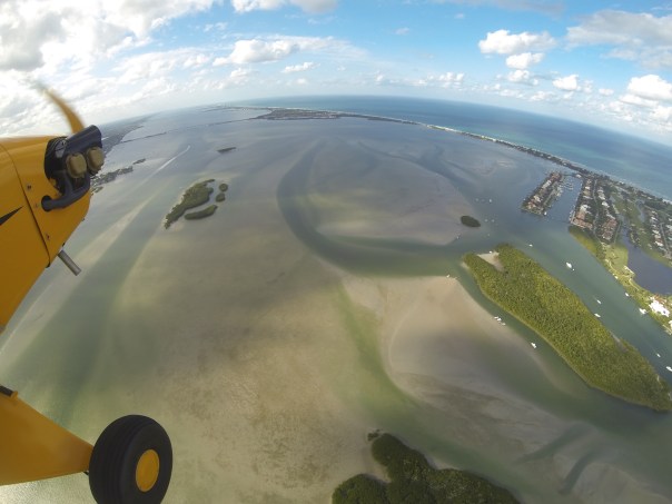
My husband, Ed, brought home these photos yesterday of the area between Sewall’s Point and Sailfish Point. The area looks pretty naked to me. Ed will fly over again and we will watch whether the seagrass comes back or not. At least these are good baseline photos for 2016.

We all know the seagrasses have been terribly compromised throughout the years of due to agriculture and developments’ rampage in Florida, and Mother Nature’s too. For instance, 2004 and 2005’s hurricanes, 1998 and this year’s El Nino…Tough times were especially visible in 2013 with the toxic Lake O “Lost Summer,” and again this year in  2016—-with the constant releases from Lake Okeechobee since January. But even with these tough conditions the seagrass usually comes back, although weaker than before.

At the end of the blog I linked a post from August 2015, where you can see the seagrasses here in 2015 that looked dark and full of algae but were visible.

Just in case you don’t know, the location between Sewall’s Point and Sailfish Point is considered the cradle of the St Lucie River/Indian River Lagoon. For years it has been labeled the “heart of the most biodiverse estuary in North America,” with more fish species that any other, over 800 (Grant Gilmore, formerly of Harbor Branch).

What a crime to allow this fishery to go into to such demise. A nursery that affects all of Florida’s east coast. An engine for our economy and quality of life for all species.

To conclude, the photos Ed took below are in two groups: taking off from Witham Airport in Stuart (1-11) and then from Jupiter Island over the waters of Sewall’s and Sailfish Point (12-26). Parts of these waters are known as the Sailfish Flats. You will notice the waters of Lake O slowly exiting the St Lucie Inlet.


DCIM103GOPRO
1. DCIM103GOPRO
DCIM103GOPRO
2. DCIM103GOPRO
DCIM103GOPRO
3. DCIM103GOPRO
DCIM103GOPRO
4. DCIM103GOPRO
DCIM103GOPRO
5. DCIM103GOPRO
DCIM103GOPRO
6. DCIM103GOPRO
DCIM103GOPRO
7. DCIM103GOPRO
DCIM103GOPRO
8. DCIM103GOPRO
DCIM103GOPRO
9. DCIM103GOPRO
DCIM103GOPRO
10. DCIM103GOPRO
DCIM103GOPRO
11. DCIM103GOPRO
1
12
2
13.
3
14.
4
15.
5
16.
6
17.
7
18.
8
19.
9
20.
10
21.
11
22.
12
23.
13
24.
14
25.
15
26.


Sewall's Point is the peninsula and Sailfish Point is the ball like formation at the south end of Hutchinson Island (R) Atlantic on far R. (Google Maps 2013)
Sewall’s Point is the peninsula between the SLR/IRL and Sailfish Point is the ball like formation at the south end of Hutchinson Island (R) Atlantic on far R. Stuart is far left with Witham Field clearly in center. (Google Maps 2013) This is the southern IRL.

Blog from 8-15 entitled “Wondering About Our Seagrasses” https://jacquithurlowlippisch.com/2015/08/24/thankful-for-blue-water-wondering-about-our-seagrasses-summer-2015-slrirl/

TC Palm 2015: Is the IRL still one of the most diverse? Tyler Treadway: http://www.tcpalm.com/news/indian-river-lagoon/health/is-indian-river-lagoon-still-among-most-biodiverse-in-us-given-all-the-pollution-ep-1127530228-332507202.html

The Coral Strand’s Fishing Riches; Today’s Sailfish Point, Along the Indian River Lagoon

1950 map by Ben McCoy of the "Coral Strand" and its riches,  today known as Sailfish Point.
1950s map of Hutchinson Island’s “Coral Strand.” Today, known as “Sailfish Point.” (Map, Ben McCoy, courtesy historic archives of Sandra Henderson Thurlow.)

How romantic, the “Coral Strand…” Like a string of pearls the riches of Hutchinson Island’s coast strung along the blue waters of the Atlantic and Indian River Lagoon. The crowing jewel, today,  known as Sailfish Point.

The above promotional map by Ben McCoy, brother, of the infamous rum runner, Captain Bill McCoy, highlights some of our area’s best features, most interesting history, and even an excerpt from a novel by Faith Baldwin:

” It was a long jut of land running into the water, upon one side was the ocean, upon the other, an inlet forming a small quiet bay. It was colored like a lithograph, strong blinding colors. The beach was so white that it dazzled, water and sky so blue they seemed unreal…”

If one looks closely at the map, fish of the area are listed around the point: Blue Fish; Sheepshead; Bass; Snapper; Pompano; Spanish Mackerel; and Tarpon everywhere…the Indian River is not noted just as the” Indian River” but the “Famous Indian River,” for fishing of course!

IMG_3626


The publication notes that five presidents, Arthur, Cleveland, Roosevelt, Taft, and Harding,  as well as Joe Jefferson, beloved  disciple of Izaak Walton, fished these waters as “who indeed among fisherman has not heard of the famous St Lucie Region, rendezvous for more than half a century for anglers  from all over the world!”

Believe it or not, according to The History of Martin County, the McCoy’s land, today’s Sailfish Point, was listed for $25,000.

It is fun to visit the dream like past, but soon or later, reality always sets in. In the 1950s the Coral Strand was sold to eccentric entrepreneur and Florida Oceanographic Society founder, James Rand, for its limited development the name was marketed as “Seminole Shores.” Later in the 1960s, the the Hutchinson Island property was sold by Harvard University to a group of Boston investors and eventually to Mobil Oil who legally tore the mangroves from the land, scared off the mosquitoes and filled it. Eventually, in the 80s the land was developed as exclusive “Sailfish Point.”

According to Dr Grant Gilmore, most famous for his long career at Harbor Branch Oceanographic, the waters/seagrasses surrounding Sailfish Point, the old Coral Strand, are truly the most diverse in the North America with over 800 types of fish, often growing baby fish, documented in these waters.

It is a crime that during rainy season, the Army Corp of Engineers often releases water from Lake Okeechobee exacerbating the pollution from our local canals killing the seagrasses in these waters, thus fish habitat destroyed. Last year, in 2013,  according to Mark Perry of Florida Oceanographic, approximately 85% of the seagrasses were destroyed.

Yes, this has happened many times, but one day, it may not come back.

For history, for today, we must fight to protect our “Coral Strand,” and our pearl, our incredibly bio-diverse waters…

___________

The History of Martin County can be purchased at the Historical Society of Martin County: (http://www.martincountyhistoricalsociety.com)