Tag Archives: understanding

Why is it So Hard To Send Water South? SLR/IRL


WCAs public photo
Water Conservation Areas as seen below the Everglades Agricultural Area. South Florida is compartmentalized to control water to “protect” farms and people ….this does always work.

We are in rain-year not seen before….

The state is overflowing…..

Our St Lucie River/Indian River Lagoon is again being destroyed by too much fresh, dirty, water….

Why is it so hard to send this water south?

It is “so hard to move water south” because the state of Florida has been compartmentalized to protect the Everglades Agricultural Area south of Lake Okeechobee and to keep-dry much of the lands that we live on. And now our waters are polluted…

Imagine, if you would, what would be going on here in South Florida now if modern man had never “conquered” it….Basically it would be a clean free-flowing marsh all the way from Shingle Creek in Orlando through Lake Okeechobee to the Everglades.

Well that it is no longer the case, is it?  Since the 1920s, and more so since the 1940s, these lands have been drained, and diked, and altered, so that humans can grow food, and live here –inadvertently polluting the system. It is an imperfect situation and we must try to understand it, so we can make it better as we all need clean water.

1850s map of Florida
Today's flow from Lake Okeechobee. (Image Everglades Foundation.)
Today’s flow into SLR and Caloosahatchee from Lake Okeechobee used to flow south.

So for the everyday person trying to figure out “what is going on” right now, let’s take a look at “today:”

  1. It has been raining lot. Since the end of January, the St Lucie River/Indian River Lagoon and Caloosahatchee are being destroyed once again as the state of Florida and the U.S. Army Corp of Engineers dump incoming waters out of Lake Okeechobee so that the Everglades Agricultural Area south of the lake and surrounding communities are not flooded. Drainage and property in our area is part of this too.
  2. A rare situation occurred this past week where Florida’s governor, Rick Scott, issued an order to release water south through a canal into the Everglades. He had to confer with the US ACOE to do this. (Due to poor water quality and safety,  just “sending water south” is not allowed. But now with so much water, it is an emergency.)
  3. The Water Conservation Areas south of the EAA, —these gigantic areas (see bottom slide) that are considered part of the Everglades and full of wildlife and in some places sacred Native American tree islands, are so full of water that they have to be dumped first. If they are lowered, then more water can enter from the Everglades Agricultural Area and hopefully Lake Okeechobee itself. Then, and only then, would there be less dumping into the St Lucie River/IRL and Caloosahatchee. We have a long way to go and its not even “rainy season.”

I commend all those working hard to alleviate the overflowing system and I encourage investment in working to improve this relic as well as investment in the children who must be part of the goal to re-plumb this system. Dr Gary Goforth shows us how it is working right now as I asked for a simple explanation to share with the River Kidz.

Gary Goforth
Gary Goforths’ image to explain “water going south.”

“Jacqui—

Due to increased stormwater pumping from the EAA and surrounding areas and direct rainfall, the water levels in the WCAs are too high. Last week the Gov. sent a letter to the Corps requesting authorization to raise water levels in the Tamiami Canal allowing increased flows into the Park through Northeast Shark River Slough. Yesterday the District began making those increased discharges through structure S-333. Whether or not the District will send additional Lake water south is yet to be seen – lowering the stage in the WCAs should help. See the map above. (from page 2 of the attached).”

Gary (http://garygoforth.net/resume.htm)
______________________________

Here you can read: Press Release Gov. Scott

FOR IMMEDIATE RELEASE
February 11, 2016
CONTACT: GOVERNOR’S PRESS OFFICE
(850) 717-9282
media@eog.myflorida.com

DEP and FWC Issue Orders to Allow Army Corps of Engineers to Ease Effects of Flooding

TALLAHASSEE, Fla. – Today, the Florida Department of Environmental Protection (DEP) and the Florida Fish and Wildlife Conservation Commission (FWC) issued orders that will allow the U.S. Army Corps to move more water south through Shark River Slough to ease the effects of flooding in South Florida. Click HERE (http://www.flgov.com/wp-content/uploads/pdfs/FFWCC.pdf)
to see the orders.

Earlier today, Governor Scott sent a letter to the U.S. Army Corps of Engineers to take immediate action to relieve the flooding of the Everglades Water Conservation Areas and the releases of water from Lake Okeechobee to the Caloosahatchee and St. Lucie Estuaries. To read the letter, click HERE (http://www.flgov.com/wp-content/uploads/2016/02/2.11.161.pdf).

South Florida and WCAs

WCA 3B: http://www.dep.state.fl.us/southeast/ecosum/ecosums/wca3b.pdf

SFWMD WCAs information sheet: http://www.sfwmd.gov/portal/page/portal/xrepository/sfwmd_repository_pdf/jtf_wca_management.pdf

SFWMD: Just the Facts on this rain year: http://www.sfwmd.gov/portal/page/portal/xrepository/sfwmd_repository_pdf/jtf_2015-16_dry_season_rainfall.pdf

A Look Back in Time at the Altering Landscape of Dredge and Fill, SLR/IRL

Dredge and fill, public photo, 2015.
Attached is a multi-image of the area in the 1887 NOAA map, the 1925 shot (partially), 1940, a 1958 NOAA map, 1970 and today.
A multi-image of the area in the 1887 NOAA map, the 1925 shot (partially), 1940, a 1958 NOAA map, 1970 and today by Todd Thurlow.

Link to video:(https://youtu.be/hsDmPmRWLRE?list=PLDaNwdmfhj15bmGNQaGhog9QpkQPAXl06)

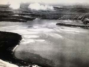
Today’s blog is a full expansion of the 1925 aerial photo I wrote about last Friday.

My brother Todd took this photo creating a time line flight of 1925 and 1940 views of the Sailfish Flats, the Indian and St. Lucie Rivers, and the St. Lucie Canal (C-44).

Todd’s video is a history lesson in “dredge and fill” which was very common throughout all south Florida and the United States until national laws in the 1970s required more scrutiny and often no longer allow such due to heavy impacts and damages on waterways and the natural environment.

Our Martin and St Lucie County canals dug by the ACOE and water management entities C-44, C-23, C-24, C-25 are dredge and fill. Sailfish Point, Sewall’s Point, and Indian River Plantation, just to name a few, have large portions that are dredge and fill. The dike around Lake Okeechobee and the work abound the FPL plant in Indiantown by Barley Barber Swamp are dredge and fill. At the time, it was “how it was done.” People did not foresee the ramifications to the environment or to people living in these areas in the future.

The land was our Play Doh…

....
1925 aerial by Bob Higgins shared by Sandra H. Thurlow. SLR/IRL

I know you will learn a lot and enjoy watching Todd’s video. The link is above.

—My questions to Todd after I saw the video included:

Jacqui: “So Todd, what are the white lines on the edge of Stuart, Rocky Point etc…more piled white sand? Looks like Jupiter Island was smaller at one point…across from Sailfish…

So how in the world did they dig out the Sailfish Point Marina and what about the straight marina of Sailfish Point that was already there from the days of Mr Rand? Also what about the FPL Pond in Indiantown? Where do you think they put that fill? Holy cow! That’s a lot of fill!

(I have adapted Todd’s words after checking concepts with him so I could present info in a simple manner.)

Todd:  “The lines on the edge of Rocky Point were probably a beachy shoreline. With it being more open water at the time and more exposed to the inlet; I’m sure there was more of a beach there. That shoreline matches perfectly the shoreline shown on the early NOAA maps – even before the inlet was there.

With respect to Jupiter Island, you are probably referring to all the spoil that was piled up at the entrance to the Great Pocket – some of that was put there when I was in middle school. The main part of Jupiter Island is more to the east and is now gone – and earlier connected to Hutchinson Island. The old Gilbert’s Bar Inlet was south of that point.

The marina on Sailfish Point was dredge fill. We have some aerials of it in the making. As was the case in areas of Sewall’s Point, the sand dug to build  small marinas or  subdivisions was piled on the land (Archipelago, Isle Addition) to make the land higher or to create completely new lands.

As far as the giant FPL pond, they probably just dug with a dragline and used the fill to make the dike around the outside of the pond and also to build up the land around FPL.”

Hmmm?

So we live in an environment altered by our forefathers, and now we are experiencing unintended consequences to the health of our St Lucie River/Indian River Lagoon. We must assist the next generation in understanding the past so that we and they can create a better water future. And that we can!

Link to Friday’s blog that inspired Todd’s video: (http://jacquithurlowlippisch.com/2015/12/18/a-1925-view-of-the-st-lucie-riverindian-river-lagoon-slrirl/)

Update: Our Deadly Canals, and the “Kiss of Death,” Lake Okeechobee, SLR/IRL

C-25 at Taylor Creek, exits into the IRL near Ft Pierce Inlet. (Photo Ed Lippisch 9-2-15)

On Wednesday, my husband Ed and I sat down for dinner. “Did you see my photos of the river? He asked.

“No, I’m sorry, I haven’t looked at them yet…”

“They are pretty dramatic,” he replied, taking a swig of his Lagunitas.

I didn’t think much more about it, but later that evening, when I reviewed his shots, I understood.

Today I will share Ed’s recent photos of the Indian River Lagoon and St Lucie River that he took on Wednesday, September 2nd between 11:30AM-1PM. The first set of photos are from the Ft Pierce area around Taylor Creek where canal C-25 dumps into the IRL near Ft Pierce Inlet. C-25’s discharge can also be from C-24 or C-23 as they are all connected and can be manipulated to flow in different ways by the South Florida Water Management District. C-25, C-24 and C-23 ARE NOT connected to Lake Okeechobee. These photos are just showing rain runoff and all that is carried along with it and brought in by rising ground waters.

Canal and basin map SLR/IRL. (Public)
Canal and basin map SLR/IRL. (Public, SFWMD)
Drainage changes to the SLR. Green is the original watershed. Yellow and pink have been added since ca.1920. (St Lucie River Initiative's Report to Congress 1994.)
Drainage changes to the SLR. Green is the original watershed. Yellow and pink have been added since ca.1920. The watershed has been unnaturlaly expanded to include up to 5 times the amount of water in the natural watershed.LO is the final blow when it comes. (St Lucie River Initiative’s Report to Congress 1994.)
SFWMD chart showing flow into C-25 over past days.

DEP C-25 Eco Summary: (http://www.dep.state.fl.us/southeast/ecosum/ecosums/c-25.pdf)

SFWMD link (http://www.sfwmd.gov/portal/pls/portal/realtime.pkg_rr.proc_rr?p_op=FORT_PIERCE)

I believe there have been recent improvements made at Taylor Creek (C-25), but perhaps there should be more as the outflow still looks like an oil spill. A cocktail of agriculture,  development, residential, and road runoff….a “river of death…”

Once a  reader wrote me saying,” Jacqui I like your blog but when it rains anywhere in the world there are these freshwater plumes….you are being misleading….”

I nicely replied. “I agree there are freshwater plumes all over the world, but I have to say, ours in the SLR/IRL region are beyond freshwater-soil plumes…they are deadly, full of heavy pollution. You can read it on agency web sites if you look hard enough…It is unnatural…and it is killing the St Lucie River/Indian River Lagoon.”

C-25 Canal in Ft Pierce. (EL)
C-25 Canal in Ft Pierce. 9-2-15. (EL)
C-25 discharging into Taylor Creek and the Marina, IRL Ft Pierce. (EL)
C-25 discharging into Taylor Creek and the Marina, IRL Ft Pierce. 9-2-15. (EL)
9-2-15 EL
9-2-15 EL
9-2-15 EL
9-2-15 EL
9-2-15. EL
9-2-15. EL

_____________________________________

This second set of photos is from the same day, but further south along the Indian River Lagoon where it meets the St Lucie River at Sewall’s Point. Here you will see a plume at Hell’s Gate, not so dramatic as the C-25 plume, but a definite plume nonetheless.

The ACOE did recently dump BASIN runoff from around the C-44 canal (see map above) in preparation for ERIKA, but they DID NOT dump from Lake Okeechobee. In fact the canal is higher than the lake. I think this blog makes clear we have enough problems even with out releases from Lake Okeechobee.

Well, hope you learned something.  Have a good Labor Day weekend as we honor the American Labor Movement and the contributions laborers have made to the strength, prosperity, and well-being of our country. —Sounds like just who we need to rework our canals….

ACOE/SFWMD slide showing breakdown of runoff into SLR. (9-1-15)
ACOE website shows
ACOE website shows no releases from S-308 or Lake O.

ACOE link to Lake O: (http://w3.saj.usace.army.mil/h2o/reports.htm)

ACOE website does show releases from S-80. In this case this is from the C-44 basin only. The basin is huge and mostly agricultural. See above chart.
Plume at Hell's Gate St Lucie River, west side of Sewall's Point. This water is from rain runoff probably from C-44, C-24, and C-23 unless the SFWMD is dumping C-23 and C-24 through C-25 in Ft Pierce. (Photo EL 9-2-15)
Plume at Hell’s Gate St Lucie River, west side of Sewall’s Point. This water is from rain runoff probably from C-44, C-24, and C-23 unless the SFWMD is dumping C-23 and C-24 through C-25 in Ft Pierce. (Photo EL 9-2-15)
9-2-15 EL Another angle of Hell's Gate and SP, SLR
9-2-15 EL Another angle of Hell’s Gate and SP, SLR
9-12-15 EL
9-12-15 EL
Incoming tide still clear around southern tip of Sewall's Point. 9-2-15
Incoming tide still clear around southern tip of Sewall’s Point. 9-2-15 EL –Hell’s Gate jutting forward far left.
Confluence of SLR/IRL between Sailfish Point and Sewall's Point. St Lucie Inlet in full view. (Photo EL 9-12-15)
Confluence of SLR/IRL between Sailfish Point and Sewall’s Point. St Lucie Inlet in full view. (Photo EL 9-12-15)
EL 9-2-15. Another view.
EL 9-2-15. Another view. Sailfish Point, SLR/IRL This areas seagrasses have still not recovered from 2013 even though water is blue in this photo.
Sailfish Flats in distance SLR/IRLEL 9-2-15.
Sailfish Flats in distance SLR/IRL EL 9-2-15.

South Florida Water Management District: (http://www.sfwmd.gov/portal/page/portal/sfwmdmain/home%20page)

Army Corp of Engineers, Lake O: (http://w3.saj.usace.army.mil/h2o/reports.htm)

Canal C-23: (http://www.dep.state.fl.us/southeast/ecosum/ecosums/c23.pdf)
Canal C-24: (http://www.dep.state.fl.us/southeast/ecosum/ecosums/c24.pdf)
Canal C-25: (http://www.dep.state.fl.us/southeast/ecosum/ecosums/c-25.pdf)
Canal C-44: (http://www.dep.state.fl.us/southeast/ecosum/ecosums/C-44%20Canal%20.pdf)