Tag Archives: video

The Old Drained Ponds of Downtown Stuart, Now Poison the St Lucie River, ~Time Capsule Flight, Todd Thurlow, SLR/IRL

Today’s blog post, created by my brother, Todd Thurlow, just totally blows my mind. His time-capsule flight through images of Google Earth, historic maps from 1850 and 1940, and an aerial from 1958, takes us on a journey through the extensive pond-land/wetland that used to be the area of Downtown Stuart and beyond. Today we all live here, most of us not even realizing what the land once was…this wetland now “magically” drains into the St Lucie River.

In Todd’s video you can see that Stuart Middle School actually is now sitting where an old pond used to be; there were ponds expanding and contracting with the rains in today’s Memorial Park; there were ponds in the areas of today’s County Courthouse; there were ponds scattered over today’s airport, Witham Field; there were extensive ponds along East Ocean Boulevard and  Dolphin as featured in last Friday’s popular blog post. Yes, there little ponds just about everywhere!

Sometimes we think the wetlands are “out west” and they are, but years ago they were also here. I have to say am guilty of this too. When I came home after university in 1986 and just about everything was developed, once again, amnesia! Look, after you watch Todd’s video, and notice the drainage canals around Monterey Blvd., St Lucie Blvd, back by Kingswoods Condo, and on the edges of Witham Field and there are many more. Of course like the grates and drains in every parking lot, these canals drain into our ailing St Lucie River. Lake Okeechobee is the big toxic hammer but there is local destruction too…

Thank you Todd and please watch the video!

Jacqui

Link to East Ocean Blvd and Dolphin Drive 1885, 1949 and 1958 video: (https://youtu.be/RCA47UsrmAc)

BY TODD THURLOW

The video is a follow-up to my sister’s 5/19/2017 blog post “The Long Forgotten Wetlands of East Ocean Boulevard, SLR/IRL” (https://jacquithurlowlippisch.com/201…)

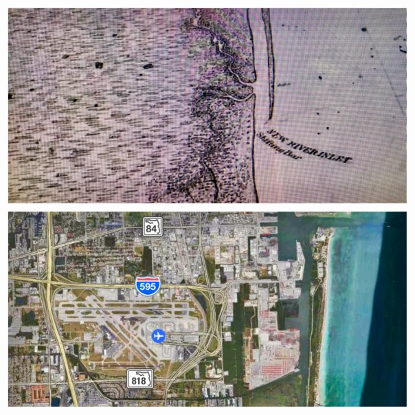
She describes a 1958 aerial photograph that hangs in my law office. The photo is from my parent’s “Thurlow/Ruhnke” collection. I had used the photo for a Google Earth presentation for Stuart Heritage on May 8, 2012. http://www.stuartheritagemuseum.com/

This is a recording of maps and photographs used for part of that presentation: 1850s Government Land Office Plats, 1940 USDA aerials and the 1958 Thurlow/Ruhnke photo.

There is no sound or text overlays but here are a few features to note:

0:50 –What was called the “Stuart Middle School Pond”. We jumped in that pond on the last day of school to celebrate graduating from 8th grade. A few years ago the pond was filled in to make room for a new building.

1:00 – The end of Fourth Street (what is now called East Ocean Blvd). East Ocean Blvd. ended at the intersection of St. Lucie Blvd/ Oriole Ave. on the left (north) side and Dolphin Drive on the right (south) before it was extended to the “Bridges to the Sea”.

1:14 – The oblique aerial described in Jacqui’s blog. Note the building in the bottom right corner. That is the Broadway Service Center which still stands today. See https://goo.gl/iODQwU

1:47 –The Evan’s Crary Bridge (aka the Ten Cent Bridge) under construction in the background

2:24 – 1940 flyover of Dolphin Drive. Note the single building in the middle of nowhere. That residence is still standing on the corner of SE 6th Street and Flamingo Ave. According to the Martin County Property Appraiser, it was built in 1925, years before the photo was taken.

2:30 –The 1940 view before our current airport. The previous Krueger Airport was off of East Ocean Blvd. Dolphin Drive continued all the way from East Ocean Blvd. to St. Lucie Blvd. by the river. If you have ever taken the “back exit” from the Stuart Air Show onto St. Lucie Blvd, that still existing right-of-way is what used to be the other end of Dolphin Drive.

~Todd Thurlow

Thomas H. Thurlow III

“Time Capsule Flights,” created by my brother, Todd Thurlow, has been a shared favorite on my blog since 2014. In these remarkable videos, Todd uses his legal and historical knowledge to create a living collage juxtaposing historic and modern-day images to achieve dramatic insights into watershed and land use changes in Florida over the past hundred years. These videos are a must for anyone wishing to understand our state’s history or working to restore its waters and lands in the future. You can access all of Todd’s videos here: http://maps.thethurlows.com.

1940s Dept. of Ag. aerials Martin Co. Dark areas are ponds/wetlands.

Thurlow and Thurlow PA: http://www.thurlowpa.com​


Flight Over the St Lucie Inlet Shows Rain Plume is NOT a Lake O Plume, SLR/IRL


Link to flight video 5-7-17: http://www.youtube.com/watch?v=dtzSmGVy790

IMG_0049.JPG
5-7-17: Hutchinson Island along the Atlantic Ocean and confluence of the St Lucie River/Indian River Lagoon, blue waters, seagrass not yet revived from 2013 and 2016 Lake O discharges. Photo Ed Lippisch
​My husband’s flight yesterday over the Atlantic Ocean, St Lucie Inlet, and St Lucie River/Indian River Lagoon is beautiful. But look carefully and you will see a light-colored brownish plume at the mouth of the St Luice Inlet entering the ocean. Finally after months of drought, it has begun raining. And when it rains… (mind you C-44 connecting the St Lucie River to Lake Okeechobee is closed now)  the re-directed run-off of waters from canals C-23, and C-24 of course still flow into our St Luice River/Indian River Lagoon.

These canals organized and built during the 1950s and 60s are part of the Central and South Florida Flood Project that the Army Corp built following the hurricane and extensive south Florida flooding of 1949. The run-off waters from these canals and the local watershed are what you see in today’s video.

As damaging as C-23 and C-24 are (they too must be reworked and redirected) they are not the damaging discharges from Lake Okeechobee that throw the St Lucie over the brink as in 2013 and especially 2016 when toxic algae covered extensive portions of the entire St Lucie.

(Photo mosaic from 2016 shows various photos by Dr Scott Kuhns, Rebecca Fatzinger, (wildlife)  JTL/Ed Lippisch, pilot Dave Stone and others.)

In spite of the light brown plume, the short video flight from Jensen to Peck’s Lake shows blue waters near the inlet and mouth of the estuary as it should be, not black water. If Governor Scott does not veto the budget, the reservoir in years to come will help offset the Lake Okeechobee destruction and open the way to truly “send the water south.” #ThankyouJoeNegron

This is very exciting, but believe me, this is no time to let down your guard, as the fight for control of Florida’s waters has really just begun.

IMG_0021.JPG
Reef system off Sailfish point is covered in black water, sediment, and nutrient pollution when Lake O is discharging. Here after months of drought, and finally some rains we can see the reefs. 5-7-17, Photo Ed Lippisch
Map SFWMD showing canals and basins. Note S-308 or structure s-308 at Lake O and S-80 down the C-44 canal AKA the St Lucie Canal. Both of these structures have to open to allow water to flow into the C-44 canal to the St Lucie River, Indian River Lagoon. All canals are destructive to the St Lucie/IRL yet it is C-44’s Lake O that puts the St Lucie system in complete and total overload.
DEP C-23:http://www.dep.state.fl.us/southeast/ecosum/ecosums/c23.pdf

DEP C-24: http://www.dep.state.fl.us/southeast/ecosum/ecosums/c24.pdf

DEP C-44 St Lucie Canal connected to Lake O: http://www.dep.state.fl.us/southeast/ecosum/ecosums/C-44%20Canal%20.pdf

photo 1 EF reservoir
Slide 1. (Dr Thomas Van Lent, Everglades Foundation, 2015) Reservoir will be located below #1, A-2 area.

Martin Health’s C.E.O. Rob Lord, A Hometown “Game Changer” for the St Lucie River/Indian River Lagoon

Robert Lord is President and C.E.O. of Martin Health Systems, formally known as Martin Memorial Hospital. “MHS” as it is known for short, is the long time top-employer for Martin County, and a respected and expanding health system.  It has been located in Martin County for 75 years. (https://www.martinhealth.org) The origianl institution sits along the shores of the St Lucie River, near downtown Stuart and has grown into both south Stuart and St Lucie County. It is a literal “lifeblood” of our communtiy.

5eb1a0d80f573ef905e657210a23ba04.jpg

I have known and admired the Lord family since my childhood. Bobby Lord, Robert Lord’s father was a local celebrity in Stuart’s early days as he is a County & Western legend. (https://en.wikipedia.org/wiki/Bobby_Lord )I attended both elementary and middle school, and graduated from Martin County High School in 1982 with Robert’s younger brother, Cabot.

I cannot express how much it meant to me last Thursday to see “Robby” Lord, accomplished attorney, now President and C.E.O. of  Martin Health Systems, in his position of leadership and influence, speak in support for Senate President Joe Negron and Senate Bill 10. A bill intended to purchase land south of Lake Okeechobee for a reservoir to begin what must happen to save our river: “clean and send more water south.”

Having known the Lord family all these years, I have followed Rob’s career, especially as my sister, Jenny,  is physician recruiter, and has served the hospital loyally for almost 20 years.

So, Bravo Rob Lord! You have created a “hometown game-change,” and as we all know, it is not easy to speak up. There are tremendous pressures to conform and accept things as they are. Over the past few years, outside powers have moved into our area influencing and blurring the lines.

I believe that Rob’s speaking out will clear the blurred lines and change the playing field forever. There is no mistaking it. Lake Okeechobee’s discharges are a health issue and must be stopped. Our state and federal government can ignore this no longer in spite of the influences of power.

okeechobee-algae-bloom-detail-1.jpg
2016, 239 sq. miles algae bloom in Lake O at S-308 entrance to C-44 and St Lucie River
IMG_0671 2.JPG
St Lucie River 2016 toxic algae bloom brought on by Lake O discharges into SLR

Excerpt from speech:

“…Good morning, my name is Rob Lord. I am President and C.E.O of Martin Health System .. I care deeply about the impact of Lake Okeechobee discharges on the estuaries. I grew up on the Indian River Lagoon. My family moved here in 1969. I have fished these water with my father, my grandfather, and my brother and nephews and nieces. No one values this eco-system more than my family. We watched it change. As CEO of Martin Health System this has been a significant challenge for us. This past year blue-green algae came to our community. We needed to post this sign in our emergency room. We treated this very much like we needed to treat the Ebola situation….”

Dr. Steven Parr, Director of Emergency Medicine at Tradition Medical Center noted  there are studies occurring now to determine whether the toxins trigger certain diseases such as Alzheimer’s, Parkinson’s, and ALS also known as Lou Gherig’s disease.

You can view the entire speech here:

MHS: https://www.martinhealth.org/martin-health-system-takes-stand-on-senate-bill-10-for-the-health-of-the-community

Rob Lord, CEO MHS
Rob Lord and Dr Parr of MHS
Rob Lord and Dr Steven Parr

Former blog on Senate Bill 10 explaining intension: https://jacquithurlowlippisch.com/2017/01/29/presidient-negrons-memorandum-to-the-florida-senate-senate-bill-10protecting-coastal-counties-from-polluted-discharges-slrirl/

The Dramatic Shifting Sands of Ft Lauderdale, SLR/IRL

FullSizeRender 4
Comparison of 1883 historic map and Google Earth image 2017, Ft Lauderdale’s New River Inlet

Today I am sharing two creations of my brother, Todd Thurlow. Entitled “Ft Lauderdale House of Refuge/Life Saving Station,” and “Short Version,”they were originally for my mother, Sandra Henderson Thurlow and Timothy Dring’s “Image of America, U.S. Life Savings Service” book presentation at the Elliott Museum.

For me, Todd’s videos are mind-boggling as they bear witness to how much and how fast we humans can change the  environment. Like an army of ants, we organize; we build; we destroy; we create…

By comparing and contrasting Google Earth maps of today with historic maps from 1883, 1887, and 1935, Todd’s “time capsule flight,” takes us through time and space to see the shifting sands of the multiple New River Inlets; Lake Mabel that morphed into Port Everglades; remnants of the forgotten Middle River that spread and contracted into new canals and developments; and of course, for mom, House of Refuge #4, that once rested north of a New River Inlet that today we can see is completely filled in, while beach-goers relax in reclining chairs like nothing ever happened!

Maybe one day we humans can use all this energy and ability to really fix our waters that have been destroyed during all this construction? Wouldn’t that be a dramatic video?

In closing, in the early 1900s, the New River… that was believed by the Seminoles to once be an underground river that collapsed and the Great Spirit revealed during an earthquake… was selected by modern-day humans as the “natural channel” to connect two of the largest drainage canals from Lake Okeechobee to the Atlantic Coast, the North New River/South New River, and the Miami.

Please watch and enjoy Todd’s videos below!

Long Version with old New River Inlet:

(Link to video: https://www.youtube.com/watch?v=Ge1bCV5Tz5Q)

Short Version:

(Link to video: https://www.youtube.com/watch?v=oYWga93XL3w)

f10595-gif

1936 historic write-up, Francis H. Miner,  Federal Writer’s Project Ft Lauderdale, https://www.broward.org/library/bienes/lii10210.htm

Click for enlarged images:

To contact Todd: http://www.thurlowpa.com and you can access all of Todd’s videos here: http://maps.thethurlows.com.

Talking About It! Even If They Didn’t Let Us Talk! FL Senate Appropriations Subcommittee on the Environment and Natural Resources, SLR/IRL

FullSizeRender_5.jpg
Dr Wendy Graham, UF

IMG_9453.JPG

Committee Members: Senator Bradley, Chair; Senator Book, Vice Chair; Senators Braynon, Hukill, Hutson. Mayfield, and Stewart

Yesterday, January 11th, Florida’s Appropriations Subcommittee on the Environment and Natural Resources met in Tallahassee. The Legislative Session has not formally started, but as most things in life, the most important stuff happens ahead of time….”in committee.”

The topic was “Discussion and testimony relating to the options for reducing harmful Lake Okeechobee discharges and Everglades Restoration.”

This meeting is being held because of Senate President Joe Negrons’ proposal to buy 60,000 acres of land in the EAA south of Lake Okeechobee for a  Reservoir. file-page1.jpg

Yesterdays’ meeting was just informational, but first impressions are very important. And anything can be killed in committee.

I think the meeting went very well. “Everyone was represented:” East Coast; West Coast; Florida Bay; The Glades and agencies or organizations of those who presented. I thought it was great. Great to see people in power and those with knowledge talking about this important issue. Remember that just a few years ago, many in Tallahassee thought the Indian River Lagoon was a movie from the 50s.

Many people drove over 12 hours to speak but Chair Bradley did not allow public comment. Bullsugar, River Kidz, Glades Residents, Islamorada, Florida Bay, CaptainsForCleanWater, Stuart residents, Ft Meyers residents, Realtors, Hotel Owners, Business Owners and more…This is very disappointing, but certainly “The Powers That Be” knew everyone was there, and surely “They” are taking about it behind closed doors.  It makes an impression when the chamber is full because those politicians know that for every person there, there are hundreds, if not thousands behind him or her who did not come…The “Powers that Be” know this. And Senator Negron knows who came too. Surely he does. He appreciates this! He is motivated by this!

Having a full-house in a sub-committee room is not an everyday occurrence for these folks. Unlike our county government the State is not as practiced at this. They generally get to operate in a vacuum–Tallahassee being so far away! Not good!

Time was short and messages many, so Chair Bradley decided to cut the meeting presenters basically in half. Thus not all the presenters who came were allowed to speak either.

Those who presented were: Senate lawyer for the committee, Ashley Istler; UF’s Wendy Graham; ACOE’s Lt Col. Jennifer Reynolds; Independent, Dr Gary Goforth; and Exec. Dir of the SFWMD, Pete Antonacci .

Those moved to January 25th were: Dr Tom Van Lent, Everglades Foundation; Drew Bartlett, DEP; and Ernie Barnett, EAA Landowners.

Overall takeaway?

There was a common theme: “we need more water storage everywhere. North, South, East and West and concerns about where the reservoir should first be or if it should be….

This is clearly a very exasperating experience for many. But isn’t it great that we are actually talking and learning about it. Together.

FullSizeRender 3.jpg
Slide UF’s  Wendy Graham, needed water storage.

All presentations are linked here and are excellent resources:http://www.flsenate.gov/PublishedContent/Committees/2016-2018/AEN/MeetingRecords/MeetingPacket_3552.pdf

Committee meeting recorded by the Florida Channel Network:http://thefloridachannel.org/videos/11117-senate-appropriations-subcommittee-environment-natural-resources/

#SupportJoeNegron

The Mystery of the “A-1 Reservoir,” SLR/IRL

IMG_7509.JPG

Road Trip Series:

What is the A-1 Reservoir?

My recent Glades tour with former Pahokee mayor, JP Sasser, lasted seven hours, and one of the most unexpected things I got to see was Storm Water Treatment Area 3-4. I have read about the STAs, flown over the STAs, and have had many discussions with engineer, Dr Gary Goforth, who is an “Architect of the STAs,” but nothing prepared me for what I felt when I unexpectedly saw an STA from the ground, or the other mystery I’d learn about that day.

So just about when my tour of the Glades was over, JP looked at me and ask: “Do you want to see the where the big reservoir was supposed to be?”

“Yes!” I exclaimed.” The reservoir? Hmmm. I’d heard stories of “the reservoir” but I really didn’t get it. Why didn’t it get finished? And what is it today? And then of course river advocates like me are supporting  Senate President Joe Negron’s reservoir. What’s the deal with all these reservoirs? So confusing…

JP stopped the car, his blue eyes dancing: “We’ll have to drive south….”

“Please!” I begged, knowing I may never have this opportunity again.

So JP turned the steering wheel 180 degrees in the middle of all the sugar fields and headed south of Belle Glade on Highway #27– driving right along the historic North New River Canal that I did know something about.

We drove, and we drove, and we drove…through sugar field after sugar field. And then, there it was, to my right, what appeared to be blowing reeds surrounded by shallow sparkling waters, silver and white, reflecting clouds in a blue sky. Birds flew by. It was beautiful. Miles long. My eyes welled up, and I thought about how amazing it was to see water in this place…”It’s like…..the Everglades….”

We drove until we got to the SFWMD’s STA 3-4 entrance gate and I asked JP to pull over so I could get a picture. I was unsure…So to JP, a Glades local, this area has to with “the reservoir,” but here we are at an STA? As I was pondering, we drove further into Broward County and JP pointed out many new-looking pump stations to send water south. I couldn’t stop wondering about “the reservoir.”

When I got home I did some research.

I believe, in short, this is the story. Please chime in if you know more.

After lawsuit/s due to long-standing polluted EAA water impacting southern lands, and after “acts of the Legislature,” in the 1990s a “Settlement Agreement,” was obtained. Thus the state of Florida had to construct 32,000 acres of storm water treatment areas (STAs) in the EAA (Everglades Agricultural Area) to clean water leaving the EAA and going into Water Conservation Areas and Everglades National Park.

By 2000 the first of six had been constructed, and by 2004 the first water ran through. Thus the building of the STAs is associated with the law suits. At the same time, Congress was working legislatively on CERP, the Comprehensive Everglades Restoration Plan. It was approved by Congress in 2000. But it was moving too slowly, so in 2006, Florida’s state legislature approved LOER (Lake Okeechobee and Estuary Recovery Plan) and under Jeb Bush chose 8 projects of CERP to “accelerate.”

One of the “Acceler 8” projects was the A-1 Reservoir. This reservoir was to be located basically right above STA 3-4 and it had three water components, one for agricultural use; one for the environment; and one for people.

Well time moves on and we are now post Jeb Bush, and into Charlie Crist’ governorship who in 2008 announced that the SFWMD would be negotiating with United States Sugar Corporation (USSC) to acquire as much as 187,000 acres of their land for Everglades Restoration! Lots of internal fighting. Environmentalist are excited about historic land acquisition, but many others are irritated that Everglades Restoration (CERP/Acceler 8) will be halted in order to purchase lands. Other sugar companies in the EAA are impacted as they share mills with USSC. US Sugar surprised everyone with this announcement. Not very nice! Some people in the ag industry are furious. Politics. Lawsuits. But such an opportunity!!! The Great Recession hits. The A-1 Reservoir and its 3 components are halted in order to possibly purchase the USSC lands.

Even more lawsuits ensue including one from the  Miccosukkee who want the reservoir completed as their lands are being depleted. Time is of the Essence.

The recession gets worse…the USSC land deal falls apart. Fewer lands are purchased. In 2010 Tea Party and “Jobs” Governor Rick Scott comes to power and negotiates with the Federal Government over of a law suit that included creating Numeric Nutrient Criteria for Phosphorus coming out of the EAA. “10 parts per billion” becomes the number. Some feel he sold out, others think it’s good.

In any case….the SFWMD now implements what the District had been planning as things were falling apart and money got tight, not a 3 part deep reservoir but rather a shallow Flow Equalization Basin, or FEB, in the A-1 reservoir lands above STA 3-4.

Thus the “Restoration Strategies,” law suit brought to the table by Rick Scott and State Legislature funded the A-1 Reservoir FEB and has more to come. What is important to note is that the A-1 FEB and the STAs were created to clean EAA sugar/agricultural runoff, due to lawsuits, not to hold, clean, and convey overflow Lake Okeechobee water that is destroying the estuaries…This is different.

And that’s why we environmentalist are talking about “a reservoir” today…a reservoir that would help the estuaries…because we don’t have one.

On the way home,  JP and I talked.

He is concerned that Negron’s 60,000 land purchase for a deep water reservoir could take so much land out of sugar production that one of the EAA’s four mills would not have enough cane to process, close, and put people out work. Pahokee cannot afford this…

“This stinks,” I thought  to myself. “Do we have to choose?” Why can’t people in the Glades and the Environment flourish? Everything is so confusing around here. This too should not be a mystery…

screenshot 3.jpg
2012 SFWMD presentation slide, Matt Morrison

Video:http://www.youtube.com/watch?v=5QKW91i-yu8

Video:http://www.youtube.com/watch?v=k-mEk_mc2wo

IMG_7510.jpg

IMG_7517.JPGIMG_7515.jpg

IMG_7519.JPGIMG_7513.JPG

file-page1.jpg

FullSizeRender 2.jpg
I noticed after writing this post that I did not report uses of reservoirs correctly thus I am adding this slide on 12-16-16, one day later. This slide shows what the reservoir compartments were proposed for in this 2012 SFWMD presentation slide by Matt Morrison. I had included “people/water supply” and this was incorrect. The entire presentation is linked below title EAA Storage Reservoirs, 2012. JTL

Timeline of Everglades Restoration DEP: http://www.dep.state.fl.us/evergladesforever/about/timeline.htm

EAA Storage Reservoirs SFWMD Matt Morrison 2012: http://evergladesrestoration.gov/content/cepp/meetings/012512/Recap_EAA_Reservoirs.pdf

A1 Reservoir history: https://www.sfwmd.gov/sites/default/files/documents/jtf_a1_feb.pdf

A1:http://xportal.sfwmd.gov/paa_dad/docs/F31147/PL9%20EAA%20A1%20Flow%20Equalization%20and%20Planning%20-%20T%20Morgan.pdf

Acceler8 :http://141.232.10.32/news/news_item_accerer8.aspx

Restoration Strategies:http://www.evergladesfoundation.org/wp-content/uploads/2016/09/Everglades-Water-Quality-Fact-sheet.pdf

CERP:https://www.nps.gov/ever/learn/nature/cerp.htm

Kait Parker’s “Toxic Lake, The Untold Story of Lake Okeechobee,” SLR/IRL

IMG_7748.jpg
Kait Parker’s website: https://kaitparker.com

Vimeo video link: (https://vimeo.com/194372466)
Website Toxic Lake video and article : (http://www.toxiclake.com)

On May 10th, 2016 there was a knock on my front door. I was expecting somebody. Kait Parker and her team from the Weather Channel had arrived via New York to do a story on the St Lucie River/Indian River Lagoon.

The group was upbeat and friendly. They interviewed Ed and me in our kitchen, and later we took them up in both the Cub and the Baron to shoot footage and to get “the view.” –The aerial view of the discharges from Lake Okeechobee that had started this year on January 29th.

What really struck me about Kait was that although this Texas girl’s beauty, talent, and ambition had moved her beyond the Treasure Coast to Atlanta’s Weather Channel, (Kait had been a well-known and loved meteorologist for three years at WPTV, the West Palm Beach/Treasure Coast NBC affiliate), she had come “home” to see what the heck was going on. She, as so many others, had heard the horrible stories of destruction facing the St Lucie River/Indian River Lagoon.

I commend Kait for coming back to see for herself and for using her fame to share our story with others. This gesture will not be forgotten and “Toxic Lake” is already making waves! Waves of change.

Thank you Kait.

13177920_866670106794672_9077317480558941624_n.jpg
With Kait Parker
13220968_866670130128003_49667077217337170_n.jpg
Getting camera and barf bag ready just in case
13177421_866670136794669_2482155466641419185_n 2.jpg
Ed explaining something.
13102866_866670116794671_5036972925007835261_n.jpg
Smile

13221478_866670173461332_4235258640774153875_n.jpg

IMG_1749.JPG
Discharges from Lake O through the St Lucie Inlet 5-10-16
IMG_1756.JPG
Plume rounding Jupiter Island through St Lucie Inlet 5-10-16
IMG_1758.JPG
St Luice Inlet 5-10-16
IMG_1763.JPG
Crossroads and SL Inlet 5-10-16

*Thank you Kait Parker,Spenser Wilking,and Andy Bowley.

“The Most Logical Route for the C-44 Canal,” Port Salerno… St Lucie River/Indian River Lagoon

This 1910 advertisement for St Lucie Inlet Farms shows and artist rendition of the proposed St Lucie Canal at the time going to the Manatee Pocket rather than the South Fork of the St Lucie River. (Courtesy of Sandra Henderson Thurlow historic archives.)
This 1914 advertisement for St Lucie Inlet Farms shows and artist rendition of the proposed St Lucie Canal at the time going to the Manatee Pocket rather than the South Fork of the St Lucie River. (Courtesy of Sandra Henderson Thurlow historic archives.)
Advertisement in booklet with photo. (Thurlow archives)
Port Salerno canal advertisement in booklet with photo. (Thurlow archives)

The saga continues!

In yesterday’s blog, I quoted a Department of Environmental Protection document stating  that the St Lucie Canal, now known as “C-44,” was originally proposed in the early 1900s to connect Lake Okeechobee to the Manatee Pocket in Port Salerno, rather than the South Fork of the St Lucie River…

So after reading my blog, my mother sends me this awesome historic real estate ad above. Can you believe it? I had heard the tales of “urban legend” for years, but now there is a visual of this historical record!

She wrote: “This was the centerfold for a booklet “Little Journeys to Salerno and the Famous St. Lucie Inlet Farms, 1914.”

Centerfold?

Funny.

I just blows my mind that those old timers were trying to turn Stuart into Miami. If the 1926  depression had not hit, they just may have been successful…

In any case there was a fight for the now dreaded C-44 canal between Stuart and Port Salerno. Stuart “won” to lose…

The historic ad above reads:

“The bird’s-eye view printed here shows the position of the tract as to transportation–the magnificent and picturesque water of the St Lucie River—the Indian River—the St Lucie Inlet where the United States Government has appropriated one-hundred thousand dollars toward the construction of a deep water harbor–the Atlantic Ocean–the automobile thoroughfare, which connects Jacksonville to Miami–and the location of the town of Port Salerno which is clearly destined to become the commercial city and the great shipping point  for the products of the winter gardens of the Everglades—the most logical route for the proposed state ship and drainage canal, which is to empty into the St Lucie Inlet and will deliver most of the products from the vast Everglades, for distribution and shipment, at tis point the proposed shore road and bridge connecting the mainland with Sewall’s Point and many other features which go to prove the enviable location of Port Salerno and the St Lucie lnlet Farms.”

Thanks mom, for another amazing piece of history!

Video showing where the C-44 did connect to the South Fork of the St Lucie River: video Todd Thurlow:

Link to video:(https://www.youtube.com/watch?v=gYI34XZUNYs&feature=youtu.be)

Link to yesterday’ blog: (http://jacquithurlowlippisch.com/2015/06/08/journey-back-in-time-to-see-the-creation-of-c-44-the-greatest-negative-impact-to-the-st-lucie-riverindian-river-lagoon/)

Time Capsule Flight to the Headwaters of the South Fork, 1940s to Today, St Lucie River/Indian River Lagoon


Prong area of South Fork, St Lucie River also showing C-44 canal's connection. (1940 US Government aerials shared by Todd Thurlow.)
Historic map with beginnings of Google overlay showing pronged area of South Fork, St Lucie River, C-44 canal’s connection, and the many ponds that once spotted the landscape that are now filled with agriculture and development. (1940 US Government aerials shared by Todd Thurlow.)
C-44 canal 1940 map with beginnings of Google overlay. (Todd Thurlow)
C-44 canal 1940 map with beginnings of Google overlay emerging. (Todd Thurlow)

Link to video: (https://www.youtube.com/watch?v=tuYkQ26OZvg&feature=youtu.be)

0:34 – Roosevelt Bridge
0:39 – Note the Old 1934 two-lane drawbridge in use. The current drawbridge was built in 1964
1:05 – Palm City Bridge
1:22 – Indian Street Bridge
1:27 – Note the increase in width of the river — in some places from approx 225 feet to 460+ feet.
3:24 – Halpatiokee Park
3:24 – Note the old Gaines Highway “Humpback” Bridge (SR-76) in use in 1940.
3:42 – Okeechobee Waterway (C-44)
4:00 – St. Lucie Lock and Dam (—timetable from Todd Thurlow)


I continue to take great pleasure in featuring the “time-capsule flight” historic map and Google Earth work of my brother, Todd Thurlow.(http://thurlowpa.com)

Today’s short video focuses on our beloved South Fork area of the St Lucie River. This video visually juxtaposes 1940s U.S. Government maps to Google Earth images of today. The video begins over an undeveloped Horseshoe Point, Sewall’s Point, and St Lucie River proper and then travels in a southern direction to the wide fork of the St Lucie River and deep along its wild, winding, and African-looking curves. One sees the old Palm City and new Veteran’s Memorial bridges come and go, and notices the  build up over time of sand in the fork (maybe some from dredging and some from sediment build-up from Lake Okeechobee releases.) This serpentine and beautiful section of the South Fork is southerly of Highway 76 that runs out to Lake Okeechobee alone the C-44 canal.  Today’s I-95 exchange is also visible.

Broad overlay of maps South Fork. (Todd Thurlow)

And the little ponds! My favorite! Just everywhere!This is most incredible to me as today they are “gone.” These hundreds, if not thousands of little ponds, once slowly increased and decreased in depth and size based on rainfall, overflowing at times, into the winding South Fork. One can still see the lush vegetation surrounding some of these areas.  Can you imaging the wildlife that used to be in our area? I so would have loved to have seen it but this trip is better than nothing! 

As the flight continues, “today’s”  development is neatly  stacked right up to the winding edge of the fork on the south side in particular…makes me think of septic tanks???

I have to say it nice that there is some land around the areas of the fork and I am sure local environmentalist have fought to keep this over the years. Nonetheless, if we had it to do over again, I think we would decide to leave a much wider birth around these important watersheds.

In the final minutes of the video we travel over the dreaded C-44 canal built in the 1920s, known in  its early years as  the “St Lucie Canal.”  This canal of course, connects Lake Okeechobee to a section of a second prong (fork) in the winding South Fork. The canal itself is wider and apparently the “connection is just “above” today’s Four Rivers which lies beyond the I-95 bridge and exchange and All American Marina.

Zooming in and out in time and place,  one can see the cleared lands around St Lucie Locks and Dam and white sand piled high from dredging on the north side of the canal….The picture fades in and out as we view the old locks structure compared to its “new and improved” version today….

I just love this stuff. It makes it all so easy to “see.”

The environmental destruction that is…I guess for others it is the sight of money and making a swamp “useful.” How ever you view it, the journey is an education.

Thank you to Todd for opening my eyes and for allowing me to travel in time and “place.”

C-44 canal Google Earth with St Lucie Locks and Dam. (Todd Thurlow Google Earth)
1940 US Gov't map showing C-44 canal cut form Todd Thurlow's video.)
1940 US Gov’t map showing C-44 canal cut from Todd Thurlow’s video. Notice agriculture fields on top of what was a stream.

_______________________________

To see more of Todd’s work on my blog, search his name on my blog’s front page, go to my blog’s “About Jacqui Thurlow-Lippisch” page or just google Todd Thurlow bluewatertt3 on You Tube.

Four Inlets South of the St Lucie Inlet? And How Much Sand Has Washed Away… Really? SLR/IRL

Comparison of 1947 USGS map/natural inlet break 1.1 miles south of  St Lucie Inlet and an aerial from Google Earth 2014.
Comparison of 1947 USGS map/and Google Earth aerial 2014–Shows natural inlet break 1.1 miles south of St Lucie Inlet in 1947 and how much Jupiter Island has migrated towards the coast since then.

“The only thing that is constant is change…” Heraclitus

In a world that is constantly in flux, it is natural to try to make things permanent. Nonetheless, this is to no avail. Nowhere is this as strikingly apparent as our barrier islands off the U.S. Atlantic coastline, right here at home, along our beautiful Indian River Lagoon.

As you know, over thousands of years, storms, winds and tides, along with other forces, have caused the openings of natural inlets along the Indian River Lagoon. Since the late 1800s, humankind, with the help of the Army Corp of Engineers, has “determined” where “permanent” inlets should be located, and filled in those otherwise forming…

My brother, Todd Thurlow, (http://thurlowpa.com) has finalized his Time Capsule Flight video of “The Inlets of Peck’s Lake and the Jupiter Narrows,” that I first shared with you in “trial version” last week. His result is even more remarkable.

Through the overlay of Google Earth, historic aerial photographs, NOAA, and USGS maps, his work provides a look back in history to see that our coastline south of today’s St Lucie Inlet has broken through at least four times to form four natural inlets since 1947.

They are: 1947 (1.1 mile south); 1952 (0.5 miles south); 1958 (1.1 south again or another in close proximity; and 1962 at Peck’s Lake during the famous Ash Wed storm.

Watch Todd’s awesome video here:  “The Inlets at Peck’s Lake and Jupiter Narrows:” https://www.youtube.com/watch?v=yO650JyADwQ

I find these “visions” absolutely beautiful.

At one point, I tried to pin Todd down about the number of barrier island breakthroughs. This was his reply:

“Jacqui – at least four breaks sounds right, but I am sure there have been an infinite number of breaks over the centuries – Joes point, Herman Bay, the Cove at IRP, Big and Little Mud creeks… “

I also tried to get an answer out of him that I have been wondering about for years: “How much shoreline along Jupiter Island near Peck’s Lake  has “disappeared?” Todd was quick to say that it is “not that easy” and that this area has probably been coming and going for a long, long  time…

Nonetheless, it is cool to think about. Here is his map. According to Todd, the red polygon in the attached image measures 445 Acres – approximately the amount of land that disappeared between Peck’s Lake and the Inlet since the 1887 NOAA chart. The yellow line measures 1770 feet – a third of a mile.

Yikes! 🙂

Shoreline loss since 1887 map as determined by
Shoreline loss close to Peck’s Lake since 1887 map.

I am excited that Todd is sharing his “evolved” Thurlow map talents, and I am looking forward to a 2015 where he is a regular guest on my blog, taking us all to a high and fluid perspective where we can see change along the St Lucie River/Indian River Lagoon in a way never before.

Happy Flying!

( Again ) Watch Todd’s awesome video here: “The Inlets at Peck’s Lake and Jupiter Narrows:” https://www.youtube.com/watch?v=yO650JyADwQ

To contact Todd directly you can post on the video itself, or email him todd@thurlowpa.com

_________________________________________________________

Peck’s Lake Ash Wednesday Storm post: (http://jacquithurlowlippisch.com/2014/12/17/mystery-revealed-exact-date-of-peck-lakes-inlet-break-through-ash-wednesday-storm-1962-indian-river-lagoon/)