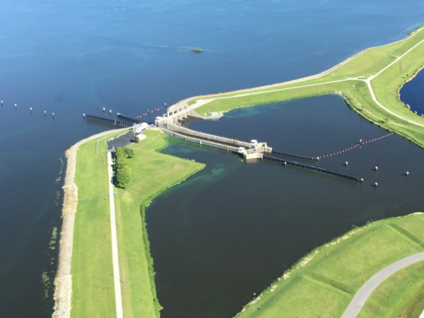
Because the Army Corp of Engineers has been discharging into the St Lucie River for the past months and the nightmare of June’s algae situation, my brother has been monitoring satellite images of Lake Okeechobee. Unfortunately, another large bloom has been documented. For awhile the large bloom that reached a size of over 200 square miles seemed to subside and was not not very visible via satellite …
Since August 19th, 2016 a visible bloom is back.
Considering what happened in June and July of this year, we as a community should be prepared for another possible river algae outbreak if this bloom significantly grows or other conditions are right–presently, Todd measured the bloom at just over 40 square miles. (See below)
Many reports and Facebook posts have already surfaced about algae blooms building up again in marinas and along shorelines. Hopefully if there is an outbreak, it won’t be as extreme as earlier this year when the Governor declared a state of emergency.
Thank you Todd for the information and the images.
We will keep reporting.
JTL
———————–
On Aug 20, 2016, at 4:12 PM, Todd Thurlow <todd@thurlowpa.com> wrote:
Jacqui:
I sent this to Mark Perry. They just posted yesterday’s Landsat 8 pass. Algae is clearly visible. The outline around the bloom is 41.4 square miles:
EAA Reservoir in white section-Planning Phase Proposed
Recently, Senator Joe Negron proposed as part of his goal-set as incoming Senate President the purchase of lands in the Everglades Agricultural Area south of Lake Okeechobee. The idea of a reservoir is not a new one, but is certainly an idea whose “time has come.” To have the Present of the Senate supporting this idea is unprecedented!
As we move forward, it is important to know that this concept has been “on the books” since the beginning of Everglades restoration and is doable. We have all been really fighting for land since 2013, but the Comprehensive Everglades Restoration Plan took shape in 2000. Unfortunately is not taking shape very quickly as it is caught in the tar-pits of government and can’t seem to break free.
So now we the state must take leadership.
The chart I want to share with you– in case you are unfamilar —so you can see the “tar-pit”— has a confusing name.
It is called the “Integrated Delivery Schedule” or (IDS).
But what does that mean?
The Army Corp of Engineers “IDS” as seen above, in many colors, is like a goal sheet, but because there are so many moving parts going on simultaneously and they because they are dependent on each other, the chart is multi-dimensional rather than just “one, two, three.” Nonetheless, the projects are “in order”…just think of it as a “list of things to do” from top to bottom…as the money comes in and the ACOE tries to get things done between politicians and stakeholders fighting.
OK to stick on point, I want to call attention to the bottom of the sheet. Third from the bottom in white you will notice a line that reads: “EAA Storage & ASR/Decomp Ph2.”
EAA storage is referring to water storage for Lake Okeechobee in the EAA; ASR is an entire other subject–like deep injection wells in the aquifer to store and retrieve water. Obviously the two concept were seen to work together.
It is all very complicated and I will write more about it in the coming months, but Senator Negron’s proposal has the potential to put the EAA reservoir higher up on the list, save the St Luice River/Indian River Lagoon, promote faster Everglades Restoration and pull us out of the tar-pits.
I for one am very thankful to Senator Negron, and I plan on pulling this Mammoth out by his tusks! 🙂
Jacqui
La Brea Tar Pits,CA
Here are some insightful links on the subject.
1. “Florida Audubon 2016: The Role of the EAA in Everglades Restoration Storing water in the EAA is one of the central components of the Comprehensive Everglades Restoration Plan (CERP). The EAA Reservoir project in CERP sought to hold water from Lake Okeechobee and farm runoff in the wet season and release this water south in the dry season. A er leaving the reservoir, freshwater would move through the network of man-made filter marshes called Stormwater Treatment Areas to remove phosphorus and other nutrients that are harmful to the plants and wildlife before continuing its path through the Central Everglades, Everglades National Park, and Florida Bay. Although an initial plan for the EAA Reservoir project was developed, the project was not constructed. The original location on for the project is now being used for two shallow water storage structures known as Flow Equalization on Basins (FEB). One FEB is part of the Central Everglades Planning Project (CEPP) project while another is part of the State of Florida’s Restora on Strategies plan required to meet water quality standards. These are important projects, but as recognized in the CEPP plan, the EAA Reservoir project is s ll necessary to achieve the goals of restoration on.1 There is an urgent need for state and federal agencies to come together to plan for water storage in the EAA.” (http://fl.audubon.org/sites/g/files/amh666/f/audubon_eaa_reservoir_may2016.pdf)
Recently, at Rivers Coalition Defense Fund meeting, president Kevin Henderson brought along the old River League’s briefcase. It had been stored away for many decades in an aging house in Stuart. In case you have not heard of them, “The River League” worked tirelessly in the 50s and 60s to stop the expanding destruction of our rivers by the Florida Flood Control District (today’s South Florid Water Management District) and the Army Corp of Engineers.
I couldn’t believe the old brief case—a beautiful sight–aged leather, and rusted metal with the sweat of those who carried it unwashed from its handle…
Kevin placed the briefcase on the table and opened it. It had not been opened in almost 50 years! No pun intended, but the sound of the locks “clicked”and suddenly it was open…
I held my breath.
I swore for a second that I saw the spirit of Ernie Lyons come out of the old briefcase like a genie. He had a giant cigar in his mouth and dark rimmed glasses. His hair was greased back and he sat at a floating desk from the old Stuart News…He was leaning back in his chair with his hands behind his head smiling from ear to ear. His teeth were stained with tobacco juice and he looked happy as a clam.
“Ernie here….Ha! Good to see you workin’ so hard! Those bastards are still killing it aren’t they? The river that is! Don’t you for a moment have despair. As you know this war has been going on for a long, long time. All of us, who have passed, are on your side. We are here. All of us who worked so hard to save the paradise of this place. You’ve probably caught on. Good versus evil is not a game. And I got a secret to tell ya. —I know the end—and good wins. Don’t give up! And know we’re here working the magic behind the scenes to help you save the St Lucie/Indian River Lagoon.”
Then he looked away and started furiously typing…the words he was writing could be seen above his head:
Today’s column, 1968
HOW THROATS OF OUR RIVERS WERE CUT BY CANALS
“There was never anything more beautiful than a natural South Florida river, like the North and South Fork of the St Lucie…
A bank of cabbage palms and live oaks draped with Spanish moss and studded with crimson-flowered air-plants and delicate wild orchids– were scenes of tropical wonder, reflected back from the mirror-like onyx surface of the water….”
When I looked up, Ernie was gone and our meeting was in full discussion…
As a reflection from the mirror of the St Lucie’s onyx-like water–I know that Ernie is here…
Ernest Lyons, Editor Stuart News and state and national award-winning conservationist: Florida Press: (http://www.flpress.com/node/63)
Ernest Lyons with Mr Oughertson, (bow tie) Timer Powers (hat) and other dignitaries ca 1960s (Photo Sandra Henderson Thurlow) The bridge between Sewall’s Point and Hutchinson Island is named in honor of Ernie Lyons.
Sandra Henderson Thurlow, photo by Lindsey Potter, 2016.Sewall’s Point Post Office, 1892.
With the help of Ms Kelly Arnold, my mother, historian Sandra Henderson Thurlow, has a web-site! My brother, Todd; my sister, Jenny; my father, Tom; and I –are very happy that people can now contact her directly to purchase or discuss her local history books.
Mom’s web site tells you where you can buy a book locally, or you can even arrange to get one at her Sewall’s Point home–she will sign the inside cover should you wish. Her work is meticulously researched, cited, and contains wonderful photographs and maps that take you back to a time of wild beauty and raw grit.
Undoubtedly because of my mother, Martin County has one of the best documented historys in Florida. All of her books, Sewall’s Point, The History of a Peninsular Community on Florida’s Treasure Coast; Stuart on the St Lucie; Historic Jensen and Eden on Florida’s Indian River; and Gilbert’s Bar House of Refuge, Home of History; are about the pioneer families that came here to live and thrive because of our waters-a precious resource that must be restored.
Visible algae around S-308 at Port Mayaca , August 3 2016.
Algae Flyover…
Included today are aerial images my husband Ed Lippisch took Wednesday, August 3rd and a satellite image for grand overview.
As far as my husband’s photos, the algae is lessened but it there. Look closely. The above image is of S-308 the structure that allows water to enter the C-44 canal, S-80 and then the St Lucie River/Indian River Lagoon. Algae blooms can be identified even from 1000 feet.
The photos included below may be recognizable to many of you showing other views of S-308, S-80, the C-44 canal and the St Lucie River in the area of Palm City. Alage blooms are present.
The Landsat satellite image also from Aug 3rd was shared by my brother Todd Thurlow. As he notes, “it has been cloudy thus viewing is difficult.” Nonetheless, these images are key to knowing what is going on in the lake.
So thank you Ed! Thank you Todd! We will continue to check things ourselves hoping another toxic algae episode is not on the way. Also Thank you to the ACOE/SFWMD for lessening the discharges from Lake Okeechobee to the estuaries since e June 29th. Better but not best. The long term goal? Clean up this water and re-plumb this state.
Rand, McNally, and Co. 1884 (Bloomfields Illustrated Historic Guide) Library of Sandra Henderson Thurlow.
Yesterday, my mother, historian Sandra Henderson Thurlow, came across this map while going through some old things…isn’t it a beauty? Look at the sprawling Everglades! Look at how the St Lucie River was not connected to Lake Okeechobee– at all…Look how at that time the inlet, Gilbert’s Bar, our inlet, was open…naturally.
When my mother came across this image, she wrote my brother and I:
“I know Todd has every map there is but still holding an original is fun and I thought the configuration of Lake Okeechobee was interesting on the 1884 Rand, McNally & Co. map tucked in the back of Bloomfield’s Illustrated Historical Guide. Of course it was too big for me to scan the whole thing. I love it that I know right where I am on this map. I am about on the former Dade/Brevard County line as I type this.” Mom
What is she talking about? Our family home in Indialucie, Sewall’s Point, named so as it is located between the St Lucie River and Indian River Lagoon, sits on the border of what once was Dade and Brevard counties. Since I was a kid there has been a piece of wood nailed to a tree, in my parent’s back yard that reads: “Dade County.”
My, how things change..too bad we didn’t save more our state’s natural water connections. Swamp or no swamp, it must have been beautiful. But I am glad our family home in now in Martin and not Dade County. 🙂
Landsat satellite photo of Lake Okeechobee 7-26-16.
I believe in not being dependent on the federal or state government, but what recently happened along the St Lucie River is ridiculous…
In the months following the June 29th, 2016 “State of Emergency”and toxic algae bloom invasion of the St Lucie River, one thing is clear. Our federal and state governments did not look out for Martin County’s best interests, instead knowlingly discharging toxic algae from the lake into the communities along the St Lucie River— with out so much as “public-peep”— until real tragedy and helath risks had struck. Then suddenly, it was like: “Oh my, where did all this algae come from?”
Well, it happened knowingly because the state and federal government (ACOE/SFWMD/ DEP/ Florida Dept of Health) knew Lake Okeechobee was not “popping” here and there with a few algae blooms as is often the case, but rather was”covered in the stuff.”
By July 2nd commonly distributed government satellite images, like the one above, were showing over 200 square miles of algae bloom that obviously had to grow over time to attain such prominance.
Anyway…the least “they” could have done was to have given the public fair warning to be careful and ready as is standard operating proceedure during a drought when wild-fire conditions are present.
But they did not.
Instead, the Department of Environmental Protection quietly took its tests, reporting to the District and the Army Corp– at their leisure— the few results they attained…They should have warned the county government of more than a bloom here and there. They should have told everyone that a dangerous situation was getting ready to occur. But they did not. Maybe they thought it wouldn’t happen? I doubt it. This is true negligence considering the first duty of government is health, saftey and welfare of the people it levies taxes from…
Thus today, I am sharing a brief exchange between my very technically-savvy brother, attorney, Todd Thurlow, and me, from earlier this week. Todd’s shared images will help us look out for ourselves. Thankfully, the recent Landsat satellite images of Lake Okeechobee, for now, look much clearer of algae than just a few months ago.
The link below the exchange will allow you see the satellite images of the lake over time, dates are also present:
Jacqui: Do the satellite images show any more algae in the lake? J
Todd: I might see some in the southwest quadrant but not definitive. As mentioned before, unfortunately, Landsat 7 has a broken instrument that causes the black lines on the image.
Today I am sharing Dr Gary Goforth’s most recent update from July 26, 2016,entitled:
“Updated Lake Flows and Loads to the Estuaries”
This information is disturbing. Please take this information and fight for change in whatever way you can. Thank you. Jacqui
———————————————————–
Dr Goforth:
Some observations for the period January 1 – July 25, 2016:
· Inflows to Lake Okeechobee are more than twice what they were this time last year
· Approximately 20 times more Lake water has been sent to the estuaries in 2016 than has been sent to the Everglades; unbelievable…
· Only 20% of Lake releases have been sent south this year, including irrigation for the EAA and other users; only 5% of Lake releases have made it to the Everglades through the STAs this year
· Lake releases to the Caloosahatchee (1.1 million acre feet or about 360 billion gallons) have been about twice the Lake flows to the St. Lucie (0.5 million acre feet, or about 167 billion gallons)
· The duration of the 2016 Lake event for the St. Lucie (178 days) has now exceeded the durations of both the 2013 and 1997-1998 events. Fortunately the Lake discharges in 2016 has been about half the flow that occurred during the 1997-1998 event.
· Lake releases to the St. Lucie have carried more than 8 times the phosphorus TMDL for the entire C-44 Canal, and more than 9 times the nitrogen TMDL … yet FDEP refuses to include the Lake loadings when they assess the C-44 Basin for compliance with the TMDL – unbelievable …
· An estimated 37 million pounds of suspended sediment has been dumped from the Lake to the St. Lucie River and Estuary; much of this accumulates on the bottom as muck.
o Because of the filtration effect of the marsh along the western shore of the Lake, the sediment load to the Caloosahatchee Estuary has fortunately been less – about 20 million pounds.
· More than 220,000 pounds of phosphorus and 2.2 million pounds of nitrogen from the Lake has been dumped to the St Lucie Estuary
o Phosphorus loads from agricultural lands in the watershed have amounted to about 390,000 pounds – 75% MORE THAN FROM THE LAKE
o Nitrogen loads from agricultural lands in the watershed have amounted to about 1.5 million pounds
o Septic tank loading of nitrogen from Martin and St. Lucie counties is roughly 5% of the total nitrogen loading to the St Lucie
· More than 340,000 pounds of phosphorus and 4.8 million pounds of nitrogen from the Lake has been dumped to the Caloosahatchee Estuary.
All brought to you by our leaders in Tallahassee and Washington …
Dr Gary Goforth
Today I will share the “Indian River Lagoon Economic Valuation Update 2016” as presented by the Treasure Coast Region Planning Council on July 15, 2016.
Links are provided for full review; as an overview, the conclusion states:
“This economic valuation update is not a status report of the IRL’s environmental health or how to address human related impacts affecting its long-term sustainability. The report simply serves to measure the economic value the IRL region stands to lose if it does not eliminate regional and local environmental inputs that are degrading the health and productivity of this estuary of national significance…the health and sustainability of the IRL will be a key determinant in the future of the region’s economy, public health and other natural, cultural, and societal values that are collectively worth far more than what has been quantified in this report.”
Sometimes I feel like I’m living in a Carl Hiaasen novel….
On June 16th, I attended a Water Resources Advisory Commission meeting of the South Florida Water Management District.
Of course, by this time, a 33 square mile algae bloom, parts toxic, had been documented in Lake Okeechobee by the Department of Environmental Protection. The St Lucie River, having been discharged into since January 29th, was looking pretty disgusting. Tempers flared.
At the WRAC meeting, water advocates, not just from Martin County, but from around South Florida were once again pleading with the SFWMD Board of Directors to “endorse buying land south of the lake in the EAA for storage, cleansing and conveyance to the Everglades in order to stop damaging discharges to the estuaries and restore freshwater to Florida Bay.”
“Send the Water South!” rang through the rafters. “Send the Water South!” As usual, the Board looked straight ahead….
And then the presentations came, and a well spoken District scientist started taking about the “The Lake Okeechobee Watershed Project,” and how it is tied into the Comprehensive Everglades Restoration Plan form 2000. —-It’s time had come…
A slide appeared showing pink, green, brown, and blue— representing the watersheds of Fisheating Creek, Indian Prairie, and Taylor Slough northwest of Lake Okeechobee.
ACOE Lake Okeechobee Watershed Project
According the Army Corp of Engineers who also attended the WRAC “the objectives of the Lake Okeechobee Watershed, or “LOW Project, “are to improve the quality, quantity, timing and distribution of water entering Lake Okeechobee, provide for better management of lake water levels, reduce damaging releases to the Caloosahatchee, and St Lucie estuaries downstream of the lake, and improve the system wide operation flexibility.”
It is a probably good project… No doubt. Do you wonder more about what goes on behind the scenes? Surely….
It is ironic that when the message of the people is “Send the Water South!” the government is finally getting around to “Blocking the Water North!”
Maybe one day we will all be on the same page so our lives don’t seem so much like a characters in a Funny Farm.
Life’s ironies abound.
Here’s the meeting information. A drive from Stuart to Okeechobee is about 40 minutes.
A “Lake Okeechobee Watershed Project NEPA Scoping Meeting will be led by ACOE’ Gretchen Ehlinger, Ph.D. Senior Biologist in the Okeechobee Auditorium, 3800 NW 16th Boulevard, Suite A, Okeechobee, FL 34972, on Tuesday, July 26 with an open house beginning at 6 p.m., followed by an official presentation at 7 p.m.
As this meeting is run by the ACOE, this meeting will only be able to address the LOW Project.
Let’s all attend the meeting even if Dr Ehlinger has to focus on the northern watershed. Maybe we should invite Carl Haaisen?
First page of letter ACOE dated June 28, 2016Page 2.
The following update Comparison of Lake O Releases was shared by Dr Gary Goforth on 7-14-16. Thank you Dr Goforth. The more informed and studied we are about where the water is going, the better chance we have to change this situation.
1. Lake Okeechobee has received more than twice the watershed inflows since January compared to last year at this time.
2. Discharges from the Lake have increased 25% compared to last year this time, however the distribution of inflows has dramatically changed compared to last year (as you so clearly know):
3. Since January 1, a. approx. 525 billion gallons of Lake water have been sent to the estuaries (including Lake Worth Lagoon) b. Lake flows are averaging about 1 billion gallons per day to the St. Lucie River/Estuary and about 2.1 billion gallons per day, and about 0.1 billion gallons /day to Lake Worth Lagoon, for a total of about 3.2 billion gallons per day c. Twenty-five (25) times more Lake water has been discharged to the estuaries than to the Everglades d Ag runoff has contributed significant nutrient loads to the St. Lucie River/Estuary: i. Nitrogen loads: 36% from ag and 54% from Lake [Dear Gov. Scott and SFWMD Board members: Martin County septic tanks contributed about 2% of the nitrogen load] ii. Phosphorus loads: 53% from ag and 30% from Lake e. 93% of the sediment load to the St. Lucie River/Estuary this year has come from the Lake discharges (37 million pounds)
4. Only 32 billion gallons of Lake water have been sent to the STAs this year – less than 1/3 of the amount sent last year at this time.
Today I share an amazing link to a website of Lake Okeechobee satellite imagery from May-June 2016 as created by my brother, Todd Thurlow. These images reflect the huge algae bloom in the lake that on July 2nd was estimated to be over 200 square miles. The algae has been discharged into the St Lucie River causing the present State of Emergency.
After going through thousands of images, Todd picked and cropped the best “bands” for each satellite. Each of the two Landsat satellites only pass every 16 days. So there are gaps. Plus, he skipped other days because of clouds. The other satellites pass daily but you will see gaps for cloudy and hazy days.
Each folder is arranged in reverse chronological order – most recent image first. The algae seemed to be worst around June 24. The current images from the low-res satellites are fairly clear. It will be interesting to see the next Landsat 8 pass on July 18.
The Army Corp of Engineers has been discharging from Lake Okeechobee since January 29th and toxic algae from the lake has been released into our St Lucie River. We are being invaded. This is horrific for the people, but what about the animals? Thank God someone is documenting their plight….
Facebook friend, Rebecca Fatzinger, is not only a voice for the St Lucie River/Indian River Lagoon, but for its wildlife. With the cries of the people “loud and clear” sometimes it seems the animals are but an afterthought for our local, state, and federal government.
I can’t help but wonder….
The Florida Wildlife Commission? The Department of Environmental Protection–have you written a statement about the wildlife implications of this bloom? What are you thinking? Are you allowed to say?
How could the St Lucie River/Indian River Lagoon once have been the most bio-diverse estuary in North America? How could we be home to some the state’s most important aquatic preserves?
Thank you to Rebecca for documenting and giving us an up close look as the animals try to cope.
Heartbreaking. Disturbing. Disgusting….
This is home?
…….Manatee….SLR……Little Blue Heron…SLR…………LimpkinDove….….Seagull at on shoreline of Atlantic Ocean, Bathtub Beach.Seagull up closePelicans diving in toxic algae–this bloom came back at from DEP 414 mpl. Bathtub Beach.PelicansSt Lucie River wide water looking towards Roosevelt bridge.Crab…Duck….Duck with baby duck…….Night Heron..Water coming out of St Lucie Locks from Lake Okeechobee with visible algae…….Little Blue Heron eyes dead fish in algaeGreat Blue Heron……OystersAnhingaOsprey waits out rain to hunt below………Armored catfishWestern side of C-44 Canal at S-80, St Lucie Locks and Dam. Algae can be seen going through S80 into the SLR hurting wildlife and people. (Photo Dr Scott Kuhns, 6-22-16)St Lucie Locks and Dam 6-25-16 Dr Scott KuhnsThis one is from Megan Remnick also Facebook friend…Aerial of S-80 at St Lucie Locks and Dam. Visible algae flowing through S-80 from western area of C-44 towards the St Lucie River. Photo Ed Lippisch.St Lucie Locks and Dam 6-21-16 JTL…..….VultureSFWMD canal and basin map. C-44 canal is the canal most southerly in the image and is connected to Lake Okeechobee.
THANK YOU TO REBECCA FATZINGER FOR SHARING HER PHOTOS!
7-12-16 NOTE: Although there are no photographs of bottlenose dolphins in this series they are certainly swimming in algae waters further from shore where the algae is more “particulate.” Yesterday, I spoke with Nic Mader of Dolphin Ecology Project and she said she has seen dolphins swimming around in their “normal” areas on her runs. The animals are very “sit specific” (territorial) like people. I also called Dr Gregory Bossert now of Georgia Aquarium formerly of Harbor Branch and his response was that this is just one more layer in an already health-affecting system— noting the animals sicknesses such as low immune system, lobo mycosis, and lessons the animal have been prone to for over 15 years since HERA Heath Environmental Risk Assessment began. Nic has stated if she gets photos she can share she will.
“Too Unthinkable” sits in the algae waters of the St Lucie River-with Evinrude motor. JTL 6-26-16
The blue-green algae, the cyanobacteria–sometimes toxic— that we first saw in aerial photos over Lake Okeechobee weeks ago, is not only here, it is everywhere…our river has been made completely fresh by our government. Now the algae is blooming fluorescent green-blue, dying a putrid brown-green, flowing out of our inlet, and poisoning not only or rivers’ shores but our beaches.
On the widest level, this is a health hazard brought upon us by a “knowing government.” Our state, federal, and local governments have seen this coming for years. The slow and steady destruction of the St Lucie River/Indian River Lagoon is well documented.
Now, in 2016, all of Martin County’s beaches and the southern most beach of St Lucie County are closed. Palm City; Stuart; Rio; Sewall’s Point, Jensen. All waters are off limits. “Don’t Touch the Water.” –A health, safety and welfare issue for the people, a nightmare for local government, and a complete environmental and economic disaster for us all.
Included for purposes of documentation– to be added to the thousands of other posts on social media this weekend— I share the following, some that were shared with me…Divided into 8 sections: 1. Algae in the waves at Bathtub Beach, by JTL; 2. algae aerials at C-44, S-80, and S-308, by Dr Scott Kuhns; 3. Lake Okeechobee and St Lucie River’s extensive algae bloom, by jet pilot Dave Stone, and local pilot Ron Rowers; 4. Rio, a residential disaster, Jeff Tucker; 5. Sewall’s Point as seen from the Evan’s Cray Bridge with a river full of algae by walker Tracy Barnes; 6. Rebecca Fatzinger’s duck eating algae; 7. my Uncle Dale Hudson’s lead to Snug Harbor’s Marina “a multimillion dollar disaster,” and 8. Really blue-algae at Central Marina, Stuart/Rio.
The outpouring of the public is immense, and the powers that be, must look our way. Document, call, write, demand, and VOTE.
Jacqui
I. Bathtub Beach, JTL
Algae rolling in the tide at Bathtub Beach on Hutchison Island, 6-26-16, JTL
II. Photos by Dr Scott Kuhns Lake Okeechobee, Port Mayaca (S-308), St Lucie Locks and Dam (S-80) and C-44 canal. All aerial photos taken 6-25-16.
St Lucie Locks and Dam 6-25-16 Dr Scott KuhnsEast side of Lake O north of Port Mayaca 6-25-16S-308 structure at Port Mayaca, heavy glare on Lke Okeechobee–bloom visible on bottom left area of photograph.C-44 Canal connecting to St Lucie RiverC-44 canalC-44 canalNear Fuge Street in Martin County approaching Palm City from C-44 as it connects to the South Fork of the St Lucie River where original curves still can be seen.
III. Professional jet pilot Dave Stone coming from Lee County to Martin County 6-26-16.
Aerial Video St Lucie River approaching North River Shores at 700 feet.
Lake Okeechobee from 13,000 feet, Dave Stone 6-26-16. Mr Stone said algae on the top of the lake is visible as far as the eye can see.Near the Harborage Marina in Stuart, Roosevelt Bridge in background
……Rio approaching Roosevelt Bridge from Sewall’s Point….….…Sewall’s Point SLRSewall’s PointFloridian on west side of SLR–the border of Martin and St Lucie Counties.
IV. Jeff Tucker, Rio
Rio St Lucie River, Jeff Tucker 6-24-16……green algae turning blue=toxic.
Duck in St Lucie River’s bloom, Rebecca Fatzinger 6-24-16.
VII. Dale Hudson, alerted Ed and I to Snug Harbor Marina where we took these photos yesterday.
Snug Harbor Marina, JTL Ed looks on.blue on walldead oysters
VIII. *Central Marina, Rio/Stuart blue algae
Central Marina blue green algae….Green algae turning blue at Central Marina 6-27-16.….
“Too Unthinkable”
“Too Unthinkable” sits in the algae waters of the St Lucie River, 6-26-16. JTLSFWMD canal and basin map. C-44 canal is the canal most southerly in the image, Lake O is released into the SLR through the C-44 canal. All canals and the lake destroy our estuary. The water must be redirected south and stored north and south. Fill the canals in; they have killed this area. JTL
Western side of C-44 Canal at S-80, St Lucie Locks and Dam. This structure discharges water from Lake Okeechobee and the agricultural C-44 basin created to drain lands into the St Lucie River/IRL. (Photo Dr Scott Kuhns, 6-22-16)
Today we will get a science lesson and see some new shocking photos…
Eutrophication: (Ecology.) (of a lake) characterized by an abundant accumulation of nutrients that support a dense growth of algae and other organisms, the decay of which depletes the shallow waters of oxygen in summer.
Today’s blog shares new aerial photos by Dr Scott Kuhns taken 6-22-16 of the extensive blue-green algae cyanobacteria bloom on the western side of the C-44 Canal being sent through S-80. The photos show a condition caused by mixture of polluted Lake Okeechobee and C-44 agricultural basin water filled with an overabundance of nitrogen and phosphorus primarily from decades of intense agricultural farming north, south and around Lake Okeechobee. Scientists have documented this condition of “eutrophication” since the late 1960s and predicted it would worsen unless serious corrections were put in place.
These nutrients, now out of control, feed algae blooms and have caused the eutrophication (or overabundance of algae growth) of Lake Okeechobee. The St Lucie River is now experiencing this due to our manmade connection to the lake. Our agricultural canals of C-44, C-23, C-24, and C-25 are culprits too. The giant releases from the lake and canals make our river fresh and seeded with algae water. Sometimes growing toxic.
The bloom on the west side of S-80 at St Lucie Locks and Dam was first documented by local activist this time in late May. The ACOE has been dumping since January 29, 2016. The river is now almost entirely fresh. Perfect for blooms.
Yesterday the St Lucie River went up in algae with multiple reports throughout the entire river from Palm City, Rio, Stuart, Jensen, and Sewall’s Point. Could there be a correlation considering the bloom started in the eutrophic lake ? How could there not be.
Dr Kuhns’ comment?
“Ridiculous!!! What does it take?”
We should not be connected to the lake. Agricultural canals should be redirected. There must be storage to treat this algae water. It should not be sent into our estuary destroying property and the environment.
C-44 at S-80 St Lucie Locks and Dam looking east. Scott Kuhns
In our continued documentation of the 2016 Lake Okeechobee event, my husband Ed and I flew over the St Lucie River/Indian River Lagoon around 5:00pm on Father’s Day, 6-19-16, at the very end of an outgoing tide. Being a stormy day, there was poor lighting, but it was easy to see the darkness that enveloped the river due to the discharges of surrounding agricultural canals, and tidal runoff, and especially the high and long-going releases from Lake Okeechobee. The dark plume hugged the coast and jutted far out into the Atlantic having no clear edge as it was churned up from high winds and waves. Nonetheless from above, it’s shadow was visible for miles all the way south to the Jupiter Inlet.
Over the weekend there were multiple reports of algae blooms throughout the river and canals. Below are photos from a family boat ride in the vicinity of the Harborage Dock in Downtown Stuart yesterday, showing foam and algae at the shoreline and tiny specks of algae dispersed throughout the entire river.
“One resident nearby of Stuart, Dr Vopal, texted: “The river is pea green! …It is time for the legislators to look at this river and consider the health of the people that live on it. ”
Over the weekend just to me and on Facebook there were reports of algae blooms not only in Stuart but along the C-44 canal, the condo/marinas along Palm City Road, the eastern area of Lake Okeechobee itself, the St Lucie Locks and Dam, the St Lucie River near Martin Memorial Hospital, Sandsprit Park, Phipps Park, and Poppleton Creek. Certainly there were many others.
As most of us know, the Army Corp of Engineers has been discharging into the St Lucie River since January 29th, 2016. The river is almost completely fresh thus these freshwater blooms— that are in the lake and upper agricultural canals prior to being released into our river (cyanobacteria is a freshwater bloom)—and then they spread throughout the river once it too is fresh from all of the discharges. Since the ACOE has been releasing since January and there has been so much rain conditions are really bad.
Ed and I will continue to document. Our region’s entire quality of life is at stake. Nothing affects our local economy more than our river. We all must continue pushing to send water south to be cleaned and conveyed to Everglades National Park as Nature intended. Call our elected officials at every level. And vote on Aug 30th in the primary.
Fondly,
Jacqui and Ed, #Skywarriors since 2013
Photos of SLR/IRL -Sewall’s Point, Sailfish Point, St Lucie Inlet, Sailfish Flat’s former seagrass beds, Jupiter Island, Atlantic Ocean’s “protected” nearshore reefs.
^-19-16 Ed Lippisch and Jacqui Thurlow-Lippisch view the confluence SLR/IRL over Sewall’s Point, Sailfish Point, Sailfish Flats, St Lucie Inlet, Jupiter Island, Atlantic Ocean.
Photos shared over weekend: Phipps Park, C-44 canal, St Lucie Locks and Dam, Sandspsprit Park also from family Father’s Day boat ride Harborage Marina, Downtown Stuart.
…
Foam and algae blooms in the area of Harborage Marina, Downtown Stuart, near the Roosevelt Bridge.
Harborage Marina near Roosevelt Bridge.
Lake O algae bloom shared by boater and posted by M. Connor just prior to weekend.
Pre weekend- Photos of an algae bloom in Lake Okeechobee on the east side of the lake. These photos were shared on Facebook by a river warrior and then by Michael Connor.
Sources of water ACOE/SFWMD june 2016SFWMD canal and basin map. According to Florida Oceanographic only 17% of water went into the SLR before the agriculture canals of C-23, C-24, and C-44 were dug in 1920s-1960s. Lake Okeechobee discharges on top of canal dumps are killing an already very stressed estuary. These waters must be redirected south and stored in other places that need the water. This overabundance of water is killing the St Lucie.River Kidz and Treasure Coast Rowing Club youth led a river clean up and planting of native vegetation to filter water during incoming and outgoing tides at Poppleton Creek. The creek was filled with an algae bloom. photo TC Palm
The name of the St Lucie River is linked to the legend of Saint Lucy who is the saint of sight. (Francesco del Cossa c. 1430 -c. 1477)
There are many names and many spellings and they are all related: Saint Lucie; Saint Lucy; Santa Lucea; Santa Lucia…they are related to the name of our ailing river.
If one lives in Martin County or St Lucie County one may drive over the bridges across the Saint Lucie River every day. But do we ever stop to think?
Saint Lucie….
Santa Lucia…
What’s in the name?
The legend and name of Saint Lucie–is an ancient one, one that was first given to our area by the Spanish who built a settlement whose inhabitants were famoulsy killed by the Ais Indians. These indians lived along what became known as the Indian River Lagoon of which the St Lucie River is part.
From what I have deduced, the word “Lucie” is related to the word “light.” Perhaps the Spanish named their settlement and the near river after the river the beautiful sunrises and sunsets reflecting heavenly light—the light of their creator…
Interestingly, Saint Lucy’s legend is one of which she defended and spoke up for herself and for her beliefs and was persecuted as a Christian as many were during her day. The story goes that the judge was so angered by her that he had her eyes torn out prior to her execution, however, when she was buried her eyes miraculously reappeared.
“1933 photograph shows Hugh Willoughby flying over Sewall’s Point and Willoughby Point in Port Sewall. The insignia of the New York Yacht Club is on th side of the biplane.” (Photo, Dale M. Hudson from Sandra H. Thurlow’s book “Sewall’s Point, A History of a Peninsular Community of Florida’s Treasure Coast”.)
One of my favorite aerial photographs from my mother’s history books on Martin County is of the infamous Hugh Willoughby flying over the St Lucie River at Sewall’s Point and Willoughby Point. In more familiar terms for boaters, this location is known as “Hell’s Gate” due to the bottle-necking of the rushing tide.
Mr Hugh de Laussat Willoughby, one of the “early birds” of aviation, and a resident of Sewall’s Point, (http://earlyaviators.com/ewilloug.htm) had the idea of locating the New York Yacht Club at the southern tip of the peninsula as envisioned in the map below. It is difficult to see in the aerial, but the insignia of the New York Yacht Club is on the side of the biplane.
The yacht club never materialized as the market crash of the late 1920s and following depression of the 1930s dashed that dream. Today many local pilots fly over the St Lucie River at this same location to photograph a different dream. –By showing the devistation, inspiring a dream for our state and federal agencies, of clean water…
Would Mr Willoughby ever have imagined his paradise would be one of controversial pollution? Never in a thousand years….
This year, the ACOE has been discharging from Lake Okeechobee since January 29th 2016; in 2013 they released May through October, and in 2014 nothing…
May the photographs or today’s ailing river inspire change, and may the spirit of Mr Willoughby keep adventure and love alive in our hearts—and the wind— ever at our backs.
New York Yacht Club Station courtesy of Sandra H. Thurlow.Cub taking photo of a cub, pilot Ron Rowers. (Photo Scott Kuhns, 2014, St Lucie River, Stuart.)St Lucie River at Sewall’s Point and Willoughby Point 2016 with dark waters from Lake O releases and area run off. (Ed Lippisch)….further away–Hell’s Gate.Sewall’s Point and Willoughby Point, 2016Sewall’s Point and Willoughby Point 2014.JTLEast side of Sewall’s Point and confluence SLR/IRL Lost Summer–(JTL)2013 SLR JTL
Stairs leading to the former home of Hubert W. Bessey, the Perkins family, and later William H. and Lucy Anne Shepherd ca. 1890-1947- via historian Sandra Henderson Thurlow.Courtesy of “Stuart on the St Lucie,” by Sandra Henderson Thurlow.Shepherd’s Park shoreline, St Lucie River, Stuart 5-30-16. The ACOE in collaboration with the SFWMD and other state agencies has been discharging waters that cannot go south to the Everglades from Lake Okeechobee as they are blocked by the EAA. The ACOE has been releasing this year since January 29, 2016. The estuary is now fresh and breeding the algae blooms of Lake Okeechobee. JTL
My earliest memories of Stuart include stairs…stairs leading to the river…
Walking in Shepherd’s Park as a child, I would ask, “Where did those stairs go Mom?” Her answer may have gone something like this…
“Jacqui, those stairs led to a great house, one of Stuart’s first, built by pioneer, Hubert Bessey. It later became the residence of William and Lucy Ann Shepherd who first came to Stuart in the early 1900s. They came, like so many did at that time, for the fishing. Stuart, you know, was “the fishing grounds of presidents” and known as “the greatest waters in America” for this sport. Mr Shepherd was president and owner of T.H. Brooks and Company, a steel corporation in Cleveland. He and his wife were generous citizens of our community. In 1947 the house was almost demolished by a hurricane, but repaired. Then in 1949, disaster struck. Right in the middle of the winter season, the house mysteriously burned to the ground, but the stairs still stand today…” (Adapted from “History of Martin County”)
Yesterday, with these 50-year-old lessons ringing in my ears, I approached the remains of the old Shepherd residence that became today’s Shepherd’s Park. I was here on Memorial Day to meet reporter Jana Eschbach, from CBS affiliate Channel 12 News in West Palm Beach. It was Jana who had alerted me to a large fluorescent green algae bloom-more than likely toxic.
I arrived early and walked around. Lots of memories. Seeing the old stairs, I thought about how they used to lead to “the fishing grounds of presidents and the greatest fishing grounds in America.” And today, less than 100 years later, they are leading to toxic algae blooms. Never in my wildest dreams would I have foreseen this as a child.
Walking around the breakwater, I thought to myself:
“I will not give up on this place–this former paradise. It could recover if given the chance. History can repeat itself in some form here for the positive. Yes, and I will remember the words of Ernest Lyons who my mother taught me about too—the writer and editor of Stuart’s early paper–a leader and inspiration in fighting against the digging of the excessive agricultural canals that have destroyed our St Lucie River.
I mused for a second and remembered his inspirational quote:
“What men do, they can undo. And the hope for our river is in the hundreds of men and women in our communities who are resolved to save the St Lucie.”
Yes.
The recovery of this river is in the people, for no government can exist in today’s age knowingly bringing this upon its people…It continues to be our time to change history.
Cover of the Witchery of Archery, 1879, Maurice Thompson.A young Maurice Thomson as photographed for book publication.
One of Lake Okeechobee’s earliest accounts was written by Maurice Thompson in 1879. Thompson’s book the “Witchery of Archery” is “credited with reviving the sport” and is still considered an American classic.
For me what is most interesting is Chapter VIII, entitled: “The Mysterious Lake,” written about an “untouched” Lake Okeechobee in South Florida just west of our St Lucie River/Indian River Lagoon.
You can go to the link at the end of this blog and read the entire book or chapter on-line, however for the blog reader, and for the beauty of the visual, I am providing some slides of the first few pages, and will quote–pulling, changing tense, and mixing a few lines:
“Lake Okeechobee, formerly called Mayaco, or Macaco, ever since the discovery of Florida by Europeans.. and long before, —has slept in a sort of poetical fog of mystery.
No doubt the far-famed story of the Fountain of Youth hidden away in the wild tangles of the Land of Flowers, being once disproved let fall something of its delightful romance upon the lake, which though hemmed in with most impassable swamps marshes, and everglades, and jealously guarded by all the cunning of its wild owners, really did and does exist…
This vast body of water lies on the Floridian peninsula, far towards its southern point, having a shape not unlike that of a great spider, from whose elliptical outline of body radiate short, crooked legs…
All around it stretch the cypress swamps and wet prairies, through which innumerable dark sluggish streams crawl like indolent serpents. Its shores are in most places low, only a few inches above the water, and a great portion is unapproachable…
The islands in the lake…are wild gardens of tropical fruit and parterres of fabulously beautiful flowers among which all sorts of gaudy birds and butterflies float and feast the year round. Springs of health giving water well up through he snow while sands and perpetual breezes blow cool from the rippling lake…
Vegetation is variegated and luxuriant beyond compare; gorgeous flowers and gay foliage make the woods and banks dazzlingly bright and beautiful…
No wonder the lake is jealousy guarded by the Indian, and still less the wonder that his descriptions of it are touched with the coloring of romance, and bathed in an atmosphere of fascination and mystery. “
How beautiful this place, our Lake Okeechobee, must have been…
*Lake Mayaco, Macaco, and names of similar derision were named after the native Maraca people of Florida who came from the upper area of the St. Johns River and migrated to the Lake Okeechobee region in the early 18th century. “Port Mayaca” on the east side of the lake in Indiantown, Martin County, preserves their name today.
1. Chapter 8 “The Witchery of Archery” first shared with me by historian, Sandra Henderson Thurlow.2.3.
Historic aerial of Port Sewall’s Golden Gate area in 1954, US1 and Dixie in foreground. (Photo courtesy of historian, Sandra Henderson Thurlow)
If you ever drive the easterly location of Indian Street in Martin County, you are in the historic subdivision for the proposed Town of Port Sewall. According to the “History of Martin County,” in 1910, Hugh Willoughby and Captain Henry Sewall established the Sewall’s Point Land Company which developed Port Sewall–of which Golden Gate is part.
I was taken by these old aerials from 1954 showing the straight roads of the Golden Gate section of the development with Sewall’s Point and St Lucie Inlet in the distance; I wanted to compare the photo to a cool old plat map and a Google map of today.
I love this old area of Martin County. So much history. It is fun to drive along Old St Lucie Boulevard and through Golden Gate. There are still remnants of the past. To visit the old Golden Gate building on Dixie Highway now getting a new life as the office of House of Hope—that was once a real estate office…..an awesome old Whiticar Boatworks from a bit later…
One of the long forgotten thing about this area is that Sewall and Willoughby’s vision for this development was a deepwater port off of Sewall’s Point. According to historian Sandra Thurlow, “The port was to be established at the junction of the waterways known today as the Crossroads. It would be called “Port Santa Lucia” and would handle the vast amounts of produce that would be shipped out of the interior of Florida via the cross state canal.”
The cross-state canal in this reference? Yes, the cross state canal of the 1920s was the dreaded St Lucie Canal or more lovingly know today as C-44…the canal that connects Lake Okeechobee to the St Lucie River/Indian River Lagoon.
Willoughby and Sewall’s development and the Port of Santa Lucia never succeeded as the Great Depression of the 1920s killed that dream. But unfortunately part of the dream of that era lived on. Today the cross state canal or since named “Okeechobee Waterway” (C-44 in Martin County) does not transport vast amounts of fresh produce, but rather is used to “manage” the waters of Lake Okeechobee and to send sediment and nutrient filled Agricultural run off to feed algae blooms and destroy the property values of Sewall’s Point, Port Sewall, Golden Gate, and the rest of Martin County.
Golden Gate 1954Historic Port Sewall plat map 1913 – Version 2 (rotated for comparison.)Google maps of Port Sewall area today, 2016.SFWMD canal and basin map. C-44 canal is the canal most southerly in the image. The canal goes from Lake Okeechobee to the St Lucie River exiting at the ocean near Sewall’s Point and Hutchinson Island.Waters off of Sewall’s Point where the Port was to be located in August 2013 during high levels of discharges from Lake Okeechobee. (JTL)Releases from Lake O at tip of Sewall’s Point at the Crossroads, 2016. Photo Ed Lippisch.
Dr. Gary Goforth has more than 30 years of experience in water resources engineering, encompassing strategic planning, design, permitting, construction, operation and program management. (Photo JTL, 2015)…
The following was written by Dr Gary Goforth as a response to U.S. Sugar Corporation’s months long ad campaign in the Stuart News. http://garygoforth.net
· The health and economies of the St. Lucie River and Estuary, the Caloosahatchee Estuary, and Florida Bay have been sacrificed for decades by the management of Lake Okeechobee for the protection of US Sugar and other agricultural lands south of the Lake.
The recent ad blitz by US Sugar appears to be an attempt to divert the public’s attention away from this preferential treatment and from an egregious betrayal of south Florida taxpayers perpetrated by US Sugar, the Florida legislature and the Governor’s administration – the failure to exercise the willing seller contract to purchase US Sugar land south of the lake. Failure to secure needed land south of the Lake is the single biggest obstacle to long-term protection of the St. Lucie and Caloosahatchee estuaries from destructive Lake discharges, and providing Florida Bay and lower east coast wellfields with needed water.
· Water storage necessary to reduce high flows to the estuaries by about 90% will require about 10% of the land in the EAA – not complete elimination of farming in the area. The recent UF Water Institute study reconfirmed what scientists have been saying for decades – additional storage and treatment beyond what is currently planned in CERP and CEPP is needed south of the Lake: “If this required storage were to be provided strictly though deep 12-ft reservoirs, new land area between approximately 11,000 and 43,000 acres would be required south of Lake Okeechobee.” The upper limit – 43,000 acres – is less than ¼ of the amount of land US Sugar was willing to sell to the state (187,000 acres).
· Regarding the numbers in the ads – some are accurate, some are completely fictitious (e.g., the distribution of water from Lake Okeechobee), and many critical numbers are missing, e.g.,
-millions of pounds of nitrogen and phosphorus from lake Okeechobee that feed algal blooms and wreak havoc on the ecology of the river, estuary, lagoon and near-shore reefs. (million off pounds of nutrients that the State of Florida ignores in their BMAP progress reports for the St Lucie River.) – the hundreds of millions of pounds of Lake Okeechobee sediment that turned a once sand-bottom clear water estuary into a muck-filled lagoon that belches blackwater every time it rains. – the hundreds of millions of dollars of economic impact to local businesses, tourism and real estate values attributable to poor water quality If you’re interested go to the SFWMD’s (or my) website.
· Most of the area that the ads calls “local waterways” did not flow into the St. Lucie River (SLR) until after the major agricultural drainage canals (C-23, C-24, C-25 and C-44) were dug, connecting more than 250,000 acres to the SLR. Historically these areas flowed north into the St. Johns River watershed, south into the Loxahatchee and Everglades watersheds, evaporated or recharged the groundwater.
· The ads ignore the fact that more than half of the “local watershed” is agriculture, and that more than half of the flows and nutrient loads to the St. Lucie River and Estuary come from agricultural land use.
· Nutrient loads from septic tanks along the Indian River Lagoon need to be addressed in cost-effective ways based on good science. Nevertheless, nutrient loading and sediment from Lake Okeechobee and agricultural runoff constitute a far greater threat to the health of the St. Lucie Estuary than does loading from Martin County septic tanks. The loading from septic tanks in Martin County have been overstated by upwards of 200-300%.
· The 2016 Florida Legislature was an unmitigated disaster for the environment of Florida, with misappropriations of Amendment 1 funds for the second year in a row and the passage of a water bill that rolled back environmental protection for the benefit of agricultural interests. What role did lobbyists for US Sugar and other agricultural interests play in this debacle? —–Dr. Gary Goforth
*Dr. Goforth has more than 30 years of experience in water resources engineering encompassing strategic planning, design, permitting, construction, operation and program management. For the last 25 years, his focus has been on large-scale environmental restoration programs in the Kissimmee-Okeechobee-Everglades ecosystem. He was the Chief Consulting Engineer during the design, construction and operation of the $700 million Everglades Construction Project, containing over 41,000 acres of constructed wetlands. He is experienced in public education, water quality treatment design and evaluation, engineering design and peer review, systems ecology, statistical hydrology, hydrologic modeling, hydrodynamic modeling, water quality modeling, environmental permit acquisition and administration, hydrologic and water quality performance analyses. (Website: http://garygoforth.net)
Lake Okeechobee’s S-308 at Port Mayaca, Ed Lippisch, May 13, 2016.
The first time I ever laid eyes on Lake Okeechobee, I was eleven years old. I remember thinking that I must be looking at the ocean because I could not see across to the other side. Just enormous!
In spite of its magnificent size, over the past century, Lake Okeechobee has been made smaller–around thirty percent smaller– as its shallow waters have been modified for human use–pushed back, tilled, planted, diked, and controlled. Today, it is managed by the South Florida Water Management District and the Army Corp of Engineers. Sprawling sugar fields, the Everglades Agricultural Area, (EAA), canals, highways, telephone poles, train tracks, processing facilities, a FPL power plant, and small cites surround it.
S-308, (the “S” standing for “structure), opens easterly into the St Lucie Canal, also known as C-44, (Canal 44). About twenty miles east is another structure, S-80, at the St Lucie Locks and Dam. It is S-80 that is usually photographed with its “seven gates of hell,” the waters roaring towards the St Lucie River/Indian River Lagoon, and the City of Stuart, but it is actually S-308 that allows the waters of Lake Okeechobee “in” from the lake in the first place.
Such a fragile looking structure to be the welcome matt of so much destruction…a sliver unto an ocean. So strange…
Today I will share some aerial photos that my husband took on Friday, May 13th, 2016 at about 700 feet above the lake. I asked Ed if from that height he could see the algae bloom so much in the news last week even though over time blooms migrate, “bloom” and then sink into the water column, becoming less visible but still lurking.
“Yes.” He replied.
” It’s harder to see from that altitude, and it depends on the light, but it’s still visible. It’s green in the brown water. The lighting shows were it is. You can see a difference in texture about 100 yards west of S-308. It is not right up against the structure, but further out. Boats are driving through it leaving a trail. It’s appears that is slowly being sucked in to the opening of the S-308 structure , like when you pull the drain out of the sink….”
S-308 at Port Mayaca, Indiantown, Martin County. Ed Lippisch, 5-13-16Dike and rim canal around Lake Okeechobee near S-308. Ed Lippisch, 5-13-16…ELopening S-308 EL…Looking towards S-308 from Lake O, boat going through bloom. Ed Lippisch, 5-13-15Remnants of bloom seen bunched in waves. Ed Lippisch 5-13-16.…EL…EL……ELC-44 or St Lucie Canal that is connected by S-308 to Lake Okeechobee.ELCloser view of algae bloom in C-44 near Indiantown “downstream” of Port Maraca and S-308 headed to Stuart. (JTL 5-10-16)SFWMD SLR basin and canal map showing S-308 and S-80 along with other structures.Algae Bloom in Lake Okeechobee: This aerial was taken last week by Will Glover as he was flying over Lake Okeechobee in a commercial airplane. It was shared on Facebook.
TC Palm’s Tyler Treadway reported on 5-13-16: “The lake bloom was spread over 33 square miles near Pahokee, the South Florida Water Management District said Thursday. The Florida Department of Health reported Friday the bloom contains the toxin microcystin, but at a level less than half what the World Health Organization says can cause “adverse health impacts” from recreational exposure.”
Pahokee is south and west of Port Maraca and S-308. (Florida Trails)
Economic Survey of Ft. Pierce and St Lucie County, 1936. Shared by historian Sandra Henderson Thurlow.
Looking back at history is such an amazing thing.
It clearly allows us to see “where we have come from,” and “how we got to where we are today”–especially in regards to our St Lucie River/Indian River Lagoon region.
In the early decades of the 1900s, Chapter 298 of Florida Statues allowed for Drainage Districts to be created, (most still exist today), by early settlers across the state so they could begin the hard work of “settlement.” These early Floridians often chose areas around rivers for their location, riches and soils.
Nonetheless, “drain baby, drain!” was the mantra.
Drainage of small tributaries of the forks of the rivers such as the St Lucie created rich farmlands and the ability to develop the lands. This was expected of settlers. During this same era, giant public works projects such as the St Lucie Canal, (C-44), linking Lake Okeechobee to the South Fork of the St Lucie River, were dug through the cooperation of state and federal governments to create what would become the Everglades Agricultural Area, or EAA, south of Lake Okeechobee.
“The rest is history…”
As we sit here today with news of a substantial blue-green algae bloom in Lake Okeechobee, and cringe as the ACOE dumps it into our estuary, I find this small booklet my mother came across recently “a through looking-glass” —–of the mentality of the times when all this over-drainage was the goal and the repercussions were not understood.
Counties all over our state had such little booklets. As you can read, this one is from St Lucie County connected to the North Fork of the St Lucie River. These hard-working people of the day dug their canal around 1936 so it would “veer to the southeast and then east to the St. Lucie River….” certainly they were not thinking about toxic algae blooms or water quality at this time. It did not even cross their radar. But it does ours….What will our little booklets look like for future historians to read ? Well, that’s for us to decide.
US Sugar ad, Stuart News, May 1, 2016.Full page ad 5-1-16 US Sugar, Stuart News.
It’s easier to communicate your message when you have billions of dollars, but it is not a limiting factor if you don’t…
Today, I will share a “Draft Report” from Dr Gary Goforth. This report is a response he has created specifically to U.S. Sugar Corporation’s May 1st full- page ad in the Stuart News entitled: “The Water That Ends Up In Our Local Waterways.”
This is one of multiple full-page ads U.S. Sugar Corporation has run in the local Martin County paper over that past months trying to “educate” our citizenry. Why are they spending so much money doing this? Why all the propaganda? Because they know that though our advocacy for the St Lucie River/Indian River Lagoon, we are changing the course of human events. For the first time, many people and some important politicians and are looking at South Florida and saying “It needs to be re-plumbed…..”
Dr Goforth (http://garygoforth.net) is no stranger to these water issues, nor to the controversy and ability to manipulate the numbers complicated by the historic and supportive relationship between those doing business in the Everglades Agricultural Area south of the lake and today’s South Florida Water Management District. Thus the intertwined propaganda.
So here we go, each idea is presented on a separate slide. You can click the slide to enlarge if you need to. Thank you Dr Goforth!
DRAFT COMMENTS ON U.S. SUGAR AD—G.GOFORTH 5-4-16
12.
3.4.5.6.7.8.9.Full page ad 5-1-16 US Sugar, Stuart News.
Today, I was looking though my family library of photos and saw one from 2005, the year Ed and I got married.
“Boy we looked young,” I thought…”We have really changed…”
Then I noticed these SFWMD nutrient loading maps in the same file, as they were “published” in 2005 as well. These awesome maps were shared by SFWMD’s Boyd Gunsalus, such a helpful and smart person when it comes to water.
These SFWMD maps were very helpful to me when I was first learning about phosphorous and nitrogen loading by basins and Lake Okeechobee. The lake’s cumulative pollution is even higher than the different canals/basins. I would bet these numbers have not changed much. The state’s approach with BMAPS and TMDL’s is to be appreciated but just too slow.
Well, Ed and I have clearly aged and changed… but the maps–I bet if they made new ones for 2005-2016, the numbers would look about the same. I can’t say I’m envious. We are meant to change. To get better.
___________________________________________
Maybe a scientist will chime in and let me know???
Willoughby Creek in Stuart, Martin County 1949. Photo courtesy of Sandra H. Thurlow.
Today I will share an historic aerial photo along Willoughby Creek together with a brief history lesson by my mother. Following, there are recent Google Map photos to compare…Stuart is still “paradise,” but sometimes I wish I were born 100 years ago. 🙂
“Jacqui, I came across this in my computer and thought it might be interesting for you to see. The date is Feb. 26, 1949. You can see Marvista… I think the house in the middle is the one that became Lee Rasch’s home. Patty Irons Child’s mother, Marge Irons was Lee’s second wife. The house at right was originally “Lagunita” built by Hugh Willoughby, Sr. (There is a big write-up on it on page 158 of the History of Martin County.) It later became a small hotel-like place call “Inlet Tides.” Both of the structures on the right side have been demolished… I am sure you know that Marvista was built by Hugh Willoughby, Jr. in 1924-25.”
—-Sandra Henderson Thurlow, Historian
You may have to “look” a bit, but if you do you will find Marvista and Lagunita today.
…2016….2016…2016 Blue dot is my home in Sewall’s Point not Willoughby Creek area. The islands that housed Marvista and Lagunita are near the left upper part of the upside side down triangle in the area of Hell’s Gate.
I don’t know about you, but I love maps! As a visual person, a map helps me understand more than words…
In his “Student Guide to Map Making” Ralph Ehrenberg writes:
“Maps are one of the most important types of documents associated with exploration. A map is a graphic representation that facilitates a spatial understanding of things, concepts, conditions, processes or events in the human world. They are used by explorers to help find their way. They are also prepared by explorers to document or record what in fact they discovered.”
It may not be the 1800s, but we are still explorers. We are trying to find a way for a better water future. One of the best ways to achieve this is to study the past. Over the weekend Facebook friend, Jim Wilson, discovered a very interesting 1866 map of Florida and the Everglades:
I emailed Dr Gary Goforth about it and this is what he said: “Portions are accurate, but feel that other portions are not accurate, e.g., the southern shore of Lake Okeechobee. Regardless, it is an amazing compilation of “known” information from 1866!”
In spite of perfection or imperfection, the map has the ability to inspire and give us a visual of what the lands and area south of Lake Okeechobee may have looked like—-I have studied many maps, but I had never had a way to envision the rivers/rivulets running south to the Everglades—–yes, the multiple “fingers” so often reported by early explorers. For me the 1866 map, in one form or another, was an “ah-ha” moment. Thank you Jim!
Maps give “vision…”
We are still explorers…
—I think we should create a “map” of what we would like to see in the future for the waters of our state, particularly south of Lake Okeechobee. Not a drawing, or a satellite, but a good-old map.
Black bobcat cubs following their mother in western Martin County on 4-11-16. Shared by Exec. Dir. David Hitzig, Busch Wildlife Sanctuary, Jupiter Florida.mom bobcat…two black bobcat juvenile cubs!
Martin County’s theme is “Our Good Nature.” We have kept some of it, unlike so many other counties in the state of Florida. I grew up appreciating this. My mother and father used to bring home injured animal for my sister, Jenny, my brother, Todd, and me to care for when we were growing up in Stuart in the 1960s, 70s, and 80s. I was taught never to be afraid of wild animals, but to respect them.
One of my favorite fascinations with local wildlife is the black, or “melanistic,” bobcats of western Martin County. I have written before about this local genetic phenomenon. In fact, it is one of my all time most popular posts. Indeed, there are more reports of black bobcats or “black panthers” occur right here, especially around Lake Okeechobee and the St Lucie Canal, than anywhere else in the state!
Yesterday, my friend and UF NRLI classmate, FWC biologist Angeline Scotten– who was in town to give a coyote presentation for Sewall’s Point and Martin County, took me to visit Busch Wildlife Sanctuary and to meet her mentor– of animal-fame– David Hitzig, Busch Wildlife’s long time executive director. I was totally impressed. What an amazing place. You must visit! http://www.buschwildlife.org
Early on in the conversation I told Mr Hitzig that for whatever reason, although an animal fan, I had never visited Busch Wildlife Sanctuary—but that I had written about a black bobcat that was documented to be at the sanctuary after being trapped near the St Lucie Canal in Western Martin County. This bobcat had been eating somebody’s chickens.
Excitedly, Mr Hitzig noted that yes, the melanistic bobcat had been at the center a few years ago, and was released. He also shared that just this month, April 2016, there had been reports of not one, but two, black bobcat cubs walking behind their mother; he later shared this rare and awesome photo.
What a sight! Two black bobcat cubs strolling happily along behind their mother in western Martin County. I love this place. Don’t you?
Black Bobcat cubs following mother in Western Martin County on 4-11-16. Shared by Busch Wildlife Center, Jupiter Florida.
_______________________________________
Correction to blog 🙂 Just after completing this post, I just received an email from David Hitzig of Busch Wildlife Sanctuary, and this black bobcat cub photo was taken in Okeechobee, a western neighbor to Martin County not Martin County itself as I thought when I wrote this! Certainly there are no boarders for the cats and Okeechobee and Martin are side by side “out west.” See map below. Wanted to note for the record. jacqui
“County lines are for people not cats….” nonetheless most black bobcats reports of the state have been in the area of western Martin County “whose “western edge boarders Okeechobee County.
__________________________________________
Thank you Mr David Hitzig for sharing this marvelous photo.
Thank you to FWC Angeline Scotten from UF NRLI Class XV for taking me to the Busch Wildllife Sanctuary and for her excellent coyote presentation for the Town of Sewall’s Point: http://nrli.ifas.ufl.edu
Today I wanted to get caught up on Langford Landing, the 53 acre property along the St Lucie River that I have written about before. This property used to belong to the late, great Frances Langford.
As time goes on, from the air, we can see that development seems to be “coming along…”
Months ago, when I first called and asked about the property, I was told that the high bluff along the river would not be flattened as rumored by some residents of Sewall’s Point–that “the elevation was why the property was so valuable.”
I guess I did not ask the right questions, because although it was not flattened, it certainly has been altered.
Ancient lore states that in the early days of the Spanish’s exploration, Don Pedro, the famed “black-beard” pirate, sat drinking wine along this bluff to watch for approaching ships. Now it is fitted and flattened for houses of a subdivision.
I think I rather it be fit for a pirate. How about you?
Lake O has been drained and lowered so that it is approximately 250 square miles smaller than it was in the mid 1800s. (SFWMD) Florida became a state in 1845.
“Navigable waters of the state” are protected under Florida law. They cannot be sold–they cannot be owned. They belong to the public…
Although the Swamp Lands Act of the 1850s allowed for drainage of Florida’s swamp lands, in some instances the drainage and claims may have been overdone. In accordance with state law “you can’t convey what you do not own.” This is part of what is known as “The Public Trust Doctrine.”
Hmmm? In all the excitement to develop, did the state break its own rules in conveying lands south and around the lake? Certainly powerful entities own those lands today.
—–That would be a bite wouldn’t it?
Let’s look a bit closer….
It is common knowledge that Lake Okeechobee has lost a tremendous amount of its former self, and that large portions of the lake have been drained and diked for agriculture and development.
Just recently while attending a University of Florida Natural Resources Leadership Institute presentation in Clewiston, Jeff Summers of the South Florida Water Management District gave a Power-Point presentation using the slide below. It shows the natural vs. altered conditions of the lake going from approximately 1000 sq miles in the 1850s to 750 square miles today. –Thus the approximate water stage has gone from 20 feet to 14 feet. Definitely a loss of navigable waters–don’t you think? Today those lands around the lake are used for growing mostly sugarcane. Today most of those lands are “owned.” How could this be as they were once under water enough to be “navigable waters of the state?”
Slide from Jeff Summer’s power point presentation SFWMD, 2016.
The excerpt below is straight out of the “Florida Bar Journal” as shared by my brother Todd. After reading the paragraph, click on the link below to read the entire article. It is certainly worth thinking about…The maps below show land ownership.
Florida Bar Journal’s article conclusion:
The Public Trust Doctrine imposes a legal duty on the state to preserve and control title and use of all lands beneath navigable water bodies, including the shore or space between ordinary high and ordinary low water, for public use and enjoyment. The people of this state have raised the protection afforded by the doctrine to constitutional stature. In the most recent challenge to this doctrine, the Florida Supreme Court relied upon this constitutional provision in reconfirming longstanding Florida law that swamp deeds do not create a private property interest in sovereignty lands. Attempts to use swamp deeds as a justification to legislatively redefine the ordinary high water boundary and thus transfer all or part of the shore to the adjacent private owner are similarly inappropriate and unconstitutional.
Map of land ownership south and around Lake O TCRPC 2016. Key below.Key to above map, 2016 TCRPC.The bigger picture: Lake O used to flow to the Everglades but is now directed to the northern estuaries St Lucie/IRL and Caloosahatchee causing great destruction. Google Earth, 2016.
Sewall’s Point, Arthur Ruhnke ca. 1950. Photo courtesy of historian Sandra Henderson Thurlow.
This is one of my favorite historic aerial photos of Sewall’s Point; I have used it before. It is on page 11 of my mother’s book “Sewall’s Point a History of a Peninsular Community on Florida’s Treasure Coast.”
Taken in the 1950s, the peninsula is basically undeveloped. The spoil islands, from dredging the Intercostal Waterway, sit to the east of the island lone and unattached…
One very special spoil island is in this photo as well. I think it is the one furthest north: Bird Island, or MC 2, is a small spoil island now off the Archipelago. Comparing the photo above and below you can see the changes to the east side of Sewall’s Point and Bird Island.
Aerial Sewall’s Point’s east side. JTL 2013.
I visited Bird Island yesterday with the Florida Wildlife Commission preparing for a field trip for their board who is meeting in South Florida this week. Bird Island was the first Critical Wildlife Area in the state of Florida designated in 20 years in 2014. This was an enormous accomplishment!
Kipp Fröhlich who was aboard boat yesterday said, “Yes it is amazing, we still don’t totally understand why the birds choose this particular island!” This is true. There are many to choose from.
One thing is for sure, the birds and humans love it here! It is a wonderful thing when wildlife and humans can reside together. Thank you FWC!
With FWC’s Ricardo Zambrano who oversaw the challenging goal of getting the idea off the ground and then achieving CWA status with the leadership of Martin County’s Deb Drum, Mike Yustin and team, the Town of Sewall’s Point, and stakeholders such as Sunshine Wildlife Tours, the commercial fishermen, and many others. After much work and broad support and years..the board of the FWC made the final approval.Ansley Taylor regional volunteer, Dr Carol Rizkalla, Ricardo Z. and Dep. Dir. Kipp Frohlich from Tallahassee. Dr Carol was instrumental in research for the success of the CWA.
Photo by Greg Braun who documented all bird life and nesting for MC during the designation.Happy wood storks on nests! JTL 4-12-16 There were Roseate spoonbills nesting too.Nesting spoonbills in mangroves 4-12-16. JTL
Seagrass….it has had a rough few years in the Indian River Lagoon-south,central, and north. Seagrass is a flowering plant, and just like plants that grow on land, it “comes and grows” with the seasons. We are just going now into spring…maybe it hasn’t flowered yet? Maybe it really grows in summer? Anyway…
My husband, Ed, brought home these photos yesterday of the area between Sewall’s Point and Sailfish Point. The area looks pretty naked to me. Ed will fly over again and we will watch whether the seagrass comes back or not. At least these are good baseline photos for 2016.
We all know the seagrasses have been terribly compromised throughout the years of due to agriculture and developments’ rampage in Florida, and Mother Nature’s too. For instance, 2004 and 2005’s hurricanes, 1998 and this year’s El Nino…Tough times were especially visible in 2013 with the toxic Lake O “Lost Summer,” and again this year in 2016—-with the constant releases from Lake Okeechobee since January. But even with these tough conditions the seagrass usually comes back, although weaker than before.
At the end of the blog I linked a post from August 2015, where you can see the seagrasses here in 2015 that looked dark and full of algae but were visible.
Just in case you don’t know, the location between Sewall’s Point and Sailfish Point is considered the cradle of the St Lucie River/Indian River Lagoon. For years it has been labeled the “heart of the most biodiverse estuary in North America,” with more fish species that any other, over 800 (Grant Gilmore, formerly of Harbor Branch).
What a crime to allow this fishery to go into to such demise. A nursery that affects all of Florida’s east coast. An engine for our economy and quality of life for all species.
To conclude, the photos Ed took below are in two groups: taking off from Witham Airport in Stuart (1-11) and then from Jupiter Island over the waters of Sewall’s and Sailfish Point (12-26). Parts of these waters are known as the Sailfish Flats. You will notice the waters of Lake O slowly exiting the St Lucie Inlet.
Sewall’s Point is the peninsula between the SLR/IRL and Sailfish Point is the ball like formation at the south end of Hutchinson Island (R) Atlantic on far R. Stuart is far left with Witham Field clearly in center. (Google Maps 2013) This is the southern IRL.
Yes, this morning was not unlike many others, here in Sewall’s Point, between the St Lucie River and Indian River Lagoon…
I get up, walk down stairs, pour a cup of coffee and ramble out into the darkness of a rising morning. The song of a bird calls through a new day. I am hopeful. I lean down and pick up the Stuart News looking for signs of sunrise east over the Indian River Lagoon. Beauty abides. Once inside, I open the paper looking through every page, and there on the back cover of Section A, yet another full-page ad from U.S. Sugar Corporation entitled “Here are the facts about moving Lake Okeechobee water south.”
“It is unbelievable how much effort U.S. Sugar is making to reframe the Lake Okeechobee discharges issue. “95% of water coming into the lake is from the north”…yes…and what else? Why is it so important for them to push this message here?
Maybe I do know why….
I go to my computer and look at my Facebook news feed. Immediately Bullsugar.org comes up.
This organization rising out of Martin County ‘s 2013 Lost Summer has gone from 0 to 61,355 friends in really less than a year. Their goal is to send the water south and fight the message that water can’t go south, especially the message of U.S. Sugar Corporation.
Interesting….is one message a reaction to the other or visa vera?
Hundreds, maybe thousands of people will see U.S. Sugar’s ad in the Stuart News today. Hundreds, and maybe thousands of people will see Bullsugar’s active Facebook page today.
One thing is for certain, the Bullsugar advocacy group is gaining strength and sophistication. They may not be able to afford full-page ads in the Stuart News, but by using social media they are giving one of the most powerful corporations in the world a “run for their money.” There is a momentum across the state for the first time in many years. Fascinating to watch. Sometimes as much as we don’t like to admit it, there’s nothing like a good fight.
1952 today’s Sailfish Point (cropped) Photo courtesy of Sandra Henderson Thurlow.
My father’s parents moved to Stuart, Florida from Syracuse, New York in 1952. This aerial photograph of the St Lucie Inlet was taken that same year so it holds personal significance to me.
This was one of many aerial photographs my parents acquired from Aurthur Ruhnke when he closed down his photography shop in Downtown Stuart during my childhood.
My mother, historian Sandra Henderson Thurlow, wrote about the image when she first shared it with me in 2010.
“Jacqui, I have quite a few Sailfish Point images I have never scanned. This is one I think might do for you. It is one of the ones that has an exact date on it. February 28, 1952. It is before any of the Rand excavation took place. People would probably enjoy seeing the way the inlet looked as well as how the land was bisected with mosquito ditches. You can also see the fresh water lake and the way the waves broke over the reef. ” Mom
What else do you see?
Below I am including a timeline of the inlet with a history up to 1994, and ACOE dredging costs up to 2000. See links below for source of ocean science.net.
St. Lucie Inlet Jetties and Detached Breakwater
St. Lucie Inlet, Florida
Dredging Records
Date(s) Construction and Rehabilitation History
1892 St. Lucie Inlet, located at the south end of Hutchinson Island, is reported to have been cut through the barrier island by local residents. Initially, the inlet was 30 ft wide and 5 ft deep.
1909 Federal interest in a navigation project recommended Federal funding of a 18-ft channel as well as a jetty along the north side of the channel.
1913 The 1913 River and Harbor Act provided initial appropriation of funds for experimental dredging of a channel 18 feet deep across the reef and ocean bar.
1916 Federal construction of the channel seaward from the mouth of the inlet began. The dredged portion of the project rapidly shoaled with sand and abandonment was recommended in 1917 and again in 1933, but no action was taken.
1926-1929 Local interests constructed the north jetty out of coquina rock to a length of 3,325 ft. The maximum dimension of the rock was 6 to 7 ft with a density of about 120 pcf. The offshore 100- to 200-ft portion of the jetty was partly covered with granite blocks. Martin and St. Lucie Improvement District dredged a turning basin at Port Sewall and an 18-ft deep by 150-ft wide by 10,000 ft long channel.
1966 Federal legislation was passed modifying the St. Lucie Inlet project to include maintenance of a 6 by 100-ft channel along the best natural deep water alignment between the Federal bar-cut channel and the Intracoastal Waterway.
1974 An extension of the north jetty and modification to it for a weir section, excavation of a sand impoundment basin, construction of a south training jetty with a fishing walkway, a 10 by 500-ft channel through the bar-cut tapering to 150 ft through the inlet, and a 7 by 100-ft channel to the Intracoastal Waterway were authorized by Congress.
1979-1982 This Federal project consisted of extension of the north jetty 650 ft (350 ft south-southeasterly and then 300 ft southeasterly), construction of a 1,400-ft south jetty with fishing walkway and a connecting rock bulkhead, construction of a 400-ft detached breakwater directly south of the north jetty extension (700 ft apart at their outer ends), an entrance channel 16 feet deep by 300 feet wide, an inlet throat channel 10 feet wide, and the dredging down to rock of a 2,500 foot long by 450 foot wide impoundment basin. Capstone was to be 6 to 10 tons (at least 75 percent to be 8 tons or more), except on the outer ends of the jetties and the detached breakwater, where the capstone would weigh 10 to 12 tons. Estimated quantities for completion of the improvements were 64,800 tons of capstone, 8,000 tons of core stone, and 28,600 tons of foundation stone. The fishing walkway was built using asphaltic concrete cap and grouting mixes. During construction there was a severe problem with scour, and large apron blankets had to be added (no details on apron or jetty cross sections).
1994 Construction by non-Federal interests of a sand tight groin about 450 feet long at an elevation of about 4 feet NGVD located about 50 feet north of and parallel to the north jetty.
Looking at Lake Okeechobee from Port Mayaca in Martin County-sky and lake are one. (Gary Goforth)
Today I am going to share an adventure of engineer and St Lucie River/Indian River Lagoon advocate Dr Gary Goforth. I will tie in his Lake Okeechobee experience with a few wonderful historic postcards from my mother, historian Sandra Henderson Thurlow. Although you couldn’t get my mother on a motorcycle if you paid her, there is a common thread. The lone cypress…
“The Lone Cypress…” You may have heard of it? As we know, cypress trees live for thousands of years. There were large forest of these magnificent trees prior to their being cut down around the turn of the last century. But a few still stand. Like this one in Moore Haven.
Dr Goforth’s account of his ride around the lake is inspirational. I have done it a couple of times by car, most recently during the final session of my UF Natural Resources Leadership Institute in Clewiston. During Dr Goforth’s ride, he visits the ancient cypress tree–the one in my mom’s historic post cards. I find this really cool. I hope you do too!
Historic map from 1948 book “Lake Okeechobee” written in 1948 by Alfred Jackson and Kathryn Hanna as part of the Rivers of America Series gives some idea of where the many cypress tree forests and others natural systems were once located.
“Hi Jacqui – I know you’re very busy as always – in fact more so these days I imagine. I got around to reading a recent blog of yours entitled “Taking the Emotion out of “Clewiston”-UF’s Natural Resources Leadership Institute, SLR/IRL.” I enjoyed it so much I thought I would share a trip I took on Sunday afternoon – a motorcycle ride around Lake Okeechobee.
It started out as a leisurely Sunday afternoon ride around the Martin County countryside. When I got to Port Mayaca I decided to head south for a couple of mile to the trailhead of the Lake to Ocean Trail – a 55-mile hike I’ll get around to tackling during cooler weather. When I got to the trailhead, I said what the heck – might as well circle the Lake. I’ve done the route before, and love to roll through the small towns that we are linked to primarily because of the Lake releases. Probably my favorite stretch is along the eastern shore of the Lake where the old-growth linear forests still remain – the magnificent cypress, bay, and others. My companion for the entire way around the Lake was the Herbert Hoover dike – almost always in sight off to my right along the small roads I took. Before I knew it I was passing through Sand Cut and Pahokee on my way to Belle Glade with their motto “Our Soil is our Fortune.” I thought of my Dad’s cousin Jack Fullenweider who was a general manager of the old Talisman sugar mill (bought by the State prior to construction of STA-3/4), and whose son, Jack, Jr. was a sheriff’s deputy in Belle Glade. I thought of Fritz Stein – a former District Board member from Belle Glade and all around good guy.
The traffic was light and the weather was beautiful. Before long I was riding along US 27/SR 80 with the big dike/dam to my right. The site of the 1928 breach and untold deaths. Along this stretch the ground level is the lowest of the entire lake’s perimeter; the Lake’s water level that day was a foot or two above ground level, which has subsided more than 6 feet since records began decades ago due to the drainage canals and ag practices. Around the rest of the Lake, the actual lake level is below the surrounding ground level.
Soon I was in Clewiston where the banners were hung announcing the upcoming Sugar Festival (today through Sunday). I thought of the many good folks who worry about the State purchasing US Sugar lands with the purported 12,000 people who would be out of a job – the folks that get angry at the estuary folks – and wonder who they turned their anger toward when US Sugar announced they had struck a voluntary deal to sell the land to Gov. Crist. What a missed opportunity, and to think the Legislature and Gov. didn’t go through with the deal – likely out of spite towards Gov. Crist – they didn’t want anything to do with extending his legacy. Deplorable. I put that out of my mind as I rode through Clewiston – a lovely little town.
Lone Cypress as it appears today.Picture taken in 1917 showing Lone Cypress tree as it appeared during the construction of Lock No. 1 in Moore Haven. (via Gary Goforth)
Before long I was in Moore Haven and thought about the big history of that small town – the early Indian canal excavations, the early dredging/draining activity of Hamilton Disston connecting the big lake to the Caloosahatchee, the farming community, the devastating hurricanes and the Lone Cypress Tree which has stood as a sentinel along the Caloosahatchee Canal since the days of Disston. The Lone Cypress Tree! I have always wanted to find that tree! So I rode around till I found it along the banks of the river/canal. It was beginning to send out the bright green needles and was remarkable in its majesty!
A few more miles on US 27 and I turned north onto SR 78 – a pleasant ride along the west side of the Lake. Pretty soon the road drops onto the floodplain of Fisheating Creek – the only unregulated tributary feeding Lake Okeechobee. I was reminded how the flows into the Lake from Fisheating Creek increased 6-fold this dry season compared to last year. All along the west side of the Lake are small mobile home and RV communities enjoying the good life!
Before long I crossed the Kissimmee River and was into the south side of Okeechobee. White pelicans ushered me along the road lined with hotels filled with seasonal fishermen and women. On around the lake and passing J&R Fish camp – busy with Sunday afternoon bikers. Many days I’ve enjoyed the free hot dogs and music. Before long I passed alongside of the FP&L cooling reservoir – site of the levee failure that occurred just before midnight in October 30, 1979.
Then I crested the bridge over the C-44 Canal with Port Mayaca off to the right. The calm water belied the massive and destructive discharges that were occurring, sending tons of sediment, algae and nutrients on their way to the troubled St. Lucie River and Estuary.
A quick turn back to the east onto SR 76, past DuPuis (my favorite public land to hike), past the sod and cane fields where once there was citrus and before long I parked the bike in the garage – it was a good ride.
Enjoy!
Gary
The attached photo of me on the motorcycle was taken on a post card perfect day in 2009 at Port Mayaca – the wind was calm, the Lake was still and the air was so clear you could see all the way across to Moore Have, some 30 miles to the southwest! I love how the water and sky blend together on the horizon.
…..Dr. Gary Goforth ready to tour Lake Okeechobee.
_______________________
After reading Gary’s account I kept thinking about that lone cypress standing like a sentinel as all has changed around it… I wrote my mother to see what she had in her history files. She sent the following four postcards from her historic collection:
We should all go ride and see it and make post cards or Facebook posts of our own!
1. Postcards courtesy of historian Sandra Henderson Thurlow.2.3.4.
Rand’s Pier being built in 1957; the pier was built out 400 feet into the Atlantic. I visited the pier often through the 60s-80s growing up in Martin County. Photo Sandra Henderson Thurlow archives.Aerial of Seminole Shores. Thurlow Archives, ca. 1950s.
I think it is typical to think the time one grew up in was the “best of times,” but I feel mine really was…
One of my fondest memories of growing up in Stuart is visiting Rand’s Pier at Seminole Shores on Hutchinson Island. This area became today’s Sailfish Point. Tromping through the hot sands, my mother would lead my brother, sister, and I down a long, winding, sand-spur/beach-sunflower covered path. Finally, we would arrive at our destination, a pier that would provide shade and shelter for the outing.
From here my brother, sister, and I would take our buckets and nets and catch baby fish, collect shells and sea glass, or dig holes and bury each other up to our necks.
The pier was a reference point for a time past, and man gone, who my mother said was famous. The man was James Rand Jr. of Rand Ledger Corporation decent who went on to build his own fortune. An impressive eccentric, a Harvard graduate, with his share of troubles—but always a gifted business man— he did many wonderful things for Martin County including becoming a benefactor to the hospital and helping found and fund the Florida Oceanographic Society. Although it was not to be his fate, he had dreams of fully developing what was then known as Seminole Shores—-today’s Sailfish Point.
According to the History of Martin County: “In the early fifties James Rand acquired part of what was known as Seminole Shores on Sailfish Point three miles south of the House of Refuge. It was his intension to develop the area with exclusive residences, a marina, a clubhouse, cabanas, and a restaurant. He built the marina, the clubhouse and yacht basin, laid out and paved a number of streets, and built some thirty cabanas in a semicircle around a swimming pool, facing the ocean that one might take advantage of either fresh or salt water bathing. He also put in the telephone lines for the south end of the island at a cost of approximately $15,000…”
When my siblings and I were running around we did not think much about the man who built the pier, or put in the telephone lines, or helped make the island accessible for us to play. But his name always stuck in my head as someone who had made a difference to Martin County. The years have passed and Martin County has changed.
Today, Sailfish Point is beautifully developed– certainly beyond what Mr Rand would have ever imagined. The pier? Time tide and time have taken it: it has washed away– But when I walk the beach I still look for it and remember the “best of times”…
Remaining pier 2009. (Photo JTL)My husband Ed under the pier in 2009. The entire pier washed away a few years later after a great storm. (JTL)Beach sunflowers…(JTL)
And yes, in recent years, Florida has had a record numbers of tourists visit. In fact, tourism is the state’s #1 industry.
With Florida’s present water woes, one wonders if tourism can hold its # 1 place for our economy.
The life blood of this state has always been its waters, and right now the waters of our state are running with blood…but our government does not see this, nor are they listening, not empathically anyway.
This disconnect is clear by the Governor’s response to the recent Central Indian River Lagoon fish kill that lauds state agencies for their clean up work rather than noting the severity of the situation:(https://content.govdelivery.com/accounts/FLDEP/bulletins/13f39d0)
Yes the Governor’s office and the state legislature are “working hard, “but a 30 year “Best Management Practices –Total Maximum Daily Load” plan and a watered down Amendment 1 compromise are not enough. The status quo response is trashing tourism. It is trashing the waters of the state. Let’s get to work and show a sense of urgency so people will continue to visit Florida in the future.
Same photo with additions. John Moran, Central IRL 2016.
This weekend I received an on-the-ground account of th Central IRL from blogger Jansen Jones : (http://phostracks.com/). Thank you Jansen.
Thank you John Moran for allowing his photos to be shared and making a special trip to the IRL to photograph. Mr Moran can be contacted at (http://springseternalproject.org)
Today I am writing to ask you please sign a petition that was put together by a young attorney I very much admire. He has been working hard for the St Lucie River/Indian River Lagoon. Please read below and sign if you wish. If you have never signed an electronic petition before, you can check it out.
P.S. Thank you to the young people holding the torch and shining the light on water issues and bringing the new technologies and opportunities to the movement.
“Explain how & confirm that Army Corps discharges into the St. Lucie & Caloosahatchee Rivers comply w/environmental laws.”
The discharges from Lake Okeechobee into the St. Lucie & Caloosahatchee Rivers by the US Army Corps of Engineers are a national environmental disaster; public safety hazard; threat to the health, livelihood, & well-being of many Floridians & Florida communities; deterrent to visitors from across the country; & are devastating to the complex ecosystems of the Indian River Lagoon, Jupiter Inlet, Pine Island, Sanibel Islands & others. Moreover, the discharges are appallingly indifferent towards stewardship of Florida’s most precious resource: its environment.
How are these discharges compliant w/environmental laws? What oversight actions have your Administration & EPA Administrator McCarthy taken to ensure that these waters are protected pursuant to law? What actions are presently underway?
________
“We the People” (https://petitions.whitehouse.gov) allows anyone to create and sign petitions asking the Obama Administration to take action on a range of issues. If a petition gets enough support, the administration will issue an official response.
Photo 3-20-16 Facebook, SWFL Clean Water Movement- Sarah Joleen / Cocoa Bch.
North, South, East, West….
You know I have really just about had it. I know you have too.
I am so tired of posting and writing about the sad state of affairs of our state waters. Every direction one turns!
This weekend many photos showed up on Facebook reporting an enormous fish kill in the Central Indian River Lagoon near Melbourne and Cocoa Beach. These photos of hovering and floating fish are very disturbing.
What is even more upsetting is when one considers the state of just about all of Florida’s waters. Is this the same state I grew up in as a child. Really?
To summarize a few recent, ongoing situations:
CENTRAL INDIAN RIVER LAGOON-experiencing “brown tide” and fish die off…
NORTHERN LAGOON: 2011-2013 Super Bloom, morality events (both north and central), 60% seagrass die off…
–ST LUCIE RIVER/S. INDIAN RIVER LAGOON: repeated discharges from Lake Okeechobee and area canals have destroyed the heath of the river. It was declared “impaired by the state in 2002. State of Emergency due to Lake O called in Feb. 2016).
—-CALOOSAHATCHEE RIVER (The western outlet for lake Okeechobee discharges, the river has been straightened, and connected to Lake O. Sometimes suffers from too little fresh water/high salinity. State of Emergency due to Lake O called in Feb. 2016)
—FLORIDA BAY: over the past few years has lost massive amounts of sea-grasses due to high salinity. When I was just there with my UF NRLI class this year, the bay looked murky. This bay historically received the fresh waters from Lake O.
—FLORIDA SPRINGS– Some have gone dry and others are lacking sufficient flow due to aquifer withdrawal. Many have experienced algae blooms. Photographer John Moran has documented their decline.
–LAKE OKEECHOBEE–deluged with water from the mostly straightened Kissimmee River and others. It has been dammed and directed to the northern estuaries.


 Recently, at Rivers Coalition Defense Fund meeting, president Kevin Henderson brought along the old River League’s briefcase. It had been stored away for many decades in an aging house in Stuart. In case you have not heard of them, “The River League” worked tirelessly in the 50s and 60s to stop the expanding destruction of our rivers by the Florida Flood Control District (today’s South Florid Water Management District) and the Army Corp of Engineers.