Tag Archives: structures

Loxahatchee Structures, People…~Wild and Scenic Rivers, Fred van Vonno

Loxahatchee Structures and People, courtesy of Fred van Vonno, Study Coordinator for the Loxahatchee and Myakka Wild and Scenic River Studies

Loxahatchee Lesson 1

Loxahatchee Lesson 2

Loxahatchee Lesson 3

Loxahatchee Lesson 4

Loxahatchee Lesson 5 

Loxahatchee Lesson 6

~Loxahatchee Structures and People, Fred van Vonno, Study Coordinator for the Loxahatchee and Myakka Wild and Scenic River Studies.

As we continue to share the slides of the late Fred van Vonno,  today’s photos fall under the categories of structures and people. Lesson 5 contains Flora and Fauna, and Lesson 4 Aerials. Thank you to my mother for archiving these photos that were once slides in Mr van Vonno’s 1980s slide shows. Thank you to our friend, Nicki van Vonno for sharing her husband’s work. 

SLIDES RELATING TO THE LOXAHATCHEE RIVER

Removed from a slide carousel used by Fred van Vonno who was a from June 1978 until 1982 for the Department of Interior National Park Service, Regional Office in Atlanta, Ga. His work involved assessing the “recreational potential of rivers and trails.” The slides were used for presentations when van Vanno was the Study Coordinator for the Loxahatchee and Myakka Wild and Scenic River studies. It is a good idea to make sure these photographs are documented because some of the photos are more than 40 years old. I would think they would have been taken around 1980. 

Sandra Thurlow 8-20

STRUCTURES

PEOPLE

As I have room in this post, I am going to include two tother categories my mother achieved even through I first thought I would leave them out. The first my mother labeled as “bad.” Some of these photos may be technology not recognized today. The next is labeled “other places.” Mr van Vonno’s research as Study Coordinator for the Wild and Scenic River Program certainly took him many places and perhaps he wished to compare some of those places to Florida, thus I am including them as well. The purpose of these photos is to share and I am hoping some who see them can see and share something I don’t know. Please write if you do! Thanks. 

ELSEWHERE

Sucking-in the Algae Bloom, Lake Okeechobee’s S-308, SLR/IRL

Lake Okeechobee's S-308 at Port Mayaca, Ed Lippisch, May 13, 2016.
Lake Okeechobee’s S-308 at Port Mayaca, Ed Lippisch, May 13, 2016.

The first time I ever laid eyes on Lake Okeechobee, I was eleven years old. I remember thinking that I must be looking at the ocean because I could not see across to the other side. Just enormous!

In spite of its magnificent size, over the past century, Lake Okeechobee has been made smaller–around thirty percent smaller– as its shallow waters have been modified for human use–pushed back, tilled, planted, diked, and controlled. Today, it is managed by the South Florida Water Management District and the Army Corp of Engineers. Sprawling sugar fields, the Everglades Agricultural Area, (EAA), canals, highways, telephone poles, train tracks, processing facilities, a FPL power plant, and small cites surround it.

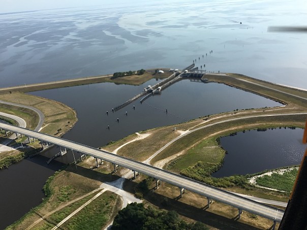
S-308, (the “S” standing for “structure), opens easterly into the St Lucie Canal, also known as  C-44, (Canal 44).  About twenty miles east is another structure, S-80, at the St Lucie Locks and Dam. It is S-80 that is usually photographed with its “seven gates of hell,” the waters roaring towards the St Lucie River/Indian River Lagoon, and the City of Stuart, but it is actually S-308 that allows the waters of Lake Okeechobee “in” from the lake in the first place.

Such a fragile looking structure to be the welcome matt of so much destruction…a sliver unto an ocean. So strange…

Today I will share some aerial photos that my husband took on Friday, May 13th, 2016 at about 700 feet above the lake. I asked Ed if from that height he could see the algae bloom so much in the news last week even though over time blooms migrate, “bloom” and then sink into the water column, becoming less visible but still lurking.

“Yes.” He replied.

” It’s harder to see from that altitude, and it depends on the light, but it’s still visible. It’s green in the brown water. The lighting shows were it is. You can see a difference in texture about 100 yards west of S-308. It is not right up against the structure, but further out. Boats are driving through it leaving a trail. It’s appears that is slowly being sucked in to the opening of the S-308 structure , like when you pull the drain out of the sink….”

S-308
S-308 at Port Mayaca, Indiantown, Martin County. Ed Lippisch, 5-13-16

Dike around Lake Okeechobee near S-308
Dike and rim canal around Lake Okeechobee near S-308. Ed Lippisch, 5-13-16

...
…EL

opening S-308
opening S-308 EL

...
…Looking towards S-308 from Lake O, boat going through bloom. Ed Lippisch, 5-13-15

...
Remnants of bloom seen bunched in waves. Ed Lippisch 5-13-16.

...
…EL

...
…EL

...

...
…EL

C-44 or St Lucie Canal
C-44 or St Lucie Canal that is connected by S-308 to Lake Okeechobee.EL

Algae bloom in C-44 near Indiantown just east of Port Maraca and S-308.
Closer view of algae bloom in C-44 near Indiantown “downstream” of Port Maraca and S-308 headed to Stuart. (JTL 5-10-16)

SFWMD basin map for SLR showing S-308 and S-80 along with other structures.
SFWMD SLR basin and canal map showing S-308 and S-80 along with other structures.

This aerial was taken last week by Will Glover and shows a larger bloom not far from Pahokee in Lake Okeechobee. Pahokee is south of S-308 on the southern rim.
Algae Bloom in Lake Okeechobee: This aerial was taken last week by Will Glover as he was flying over Lake Okeechobee in a commercial airplane. It was shared on Facebook.

TC Palm’s Tyler Treadway reported on 5-13-16: “The lake bloom was spread over 33 square miles near Pahokee, the South Florida Water Management District said Thursday. The Florida Department of Health reported Friday the bloom contains the toxin microcystin, but at a level less than half what the World Health Organization says can cause “adverse health impacts” from recreational exposure.”

Map of cities around Lake O and trail you can take to see this area.

Pahokee is south and west of Port Maraca and S-308. (Florida Trails)