Tag Archives: caloosahatchee

Forever Changed

Category 4 Hurricane Ian at impact September 28, 2022 NOAA via eyeonlakeo.com

I am blogging from my phone so I do not know what this post will look like when it’s published. On my street in Sewall’s Point, there is no power. Not for one second will I complain knowing what so many have lost on Florida’s southwest coast and around the state. Hurricane Ian has only just begun to tell his story. We all will be living with his impact for years.

From the bottom of my heart I am wishing those who are suffering comfort. “West Coasters” are indeed our brothers and sisters. In 2013 when the River Movement was rising from the filth and black waters of the St Lucie and Caloosahatchee’s “Lost Summer” we met at the Sugarland Rally in Clewiston. East & West met to bind for the fight against polluting discharges from Lake Okeechobee, and we indeed planted seeds that inspired a youth movement, and changed water policy and politics throughout the state of Florida. Our influence grew with each terrible event- 2013, 2016, 2018. Over time, this east/west partnership became much, much, more, and yes, like every family, we’ve had our challenges, our problems. The ACOE’s LOSOM, the most recent challenge, publicly pitted us against each other for over three years, but we finally found a fair center for ourselves and others.

The past couple of days, I’ve been thinking about SFWMD Chairman, Chauncey Goss who I sit next to every month at our governing board meetings. Chauncey’s family lives on Sanibel and his father worked to create the special low density, native character of the Island. May it be rebuilt in the same nature respecting spirit.

As we all know, all we have can be taken from us, thus all we really have is that within us. May we be good neighbors to those left in Ian’s path, as it is not just them, we are all forever changed.

Miami Herald, 9-29-22: https://apple.news/AT8SaoFURQCCE0xkfbO0dvg

Tales of the Southern Loop, Cape Sable, Marco Island, Ft Meyers, Moore Haven, Clewiston, Stuart

Tales of the Southern Loop, Stuart to Boyton, Part 1

Tales of the Southern Loop, Boyton to Miami, Part 2

Tales of the Southern Loop, Miami to Tavernier, Part 3

Tales of the Southern Loop, Tavernier to Marathon, Part 4    

Tales of the Southern Loop, Marathon to Key West, Part 5

Tales of the Southern Loop, Key West to Cape Sable, Part 6

Tales of the Southern Loop, Cape Sable, Marco Island, Ft Meyers, Moore Haven, Clewiston, Stuart, Part 7

I’m a bit late in getting this final Southern Loop published. Between the presidential election, Tropical Storm Eta, seemingly endless overcast skies, ACOE discharges from Lake Okeechobee, and resurging Covid-19, I have had a hard time keeping myself on track!

This post is split into seven sections for dates 9-17-20 though 9-22-20. It shares highlights of the second half of the Southern Loop along the waters of Cape Sable, Marco Island, Ft Meyers, Moore Haven, Clewiston, and back to Stuart. A fantastic trip! 

I. MARCO ISLAND, GULF OF MEXICO 

 Having left Cape Sable, approaching from the Gulf of Mexico, Marco Island looked like a city rising from the water. It is actually the first and largest of a chain, that beyond it, comprises Ten Thousand Island National Wildlife Refuge and is adjacent to Everglades National Park.

Well before the era of high rise resort hotels, the island’s beach was surrounded by mangrove forests, and the Calusa Indians thrived here for possibly thousands years. Docking at Marco Island Marina was one of Ed and my most difficult experiences with the winds tearing along the seawalled canal as we struggled for direction. Once there, it was paradise. We wish to go back.

-Approaching Marco Island in the Gulf of Mexico-Marco Island is part of 10,000 Islands

II. FT MEYERS, CAPE CORAL, CALOOSAHATCHEE 

The following day, after running just offshore in the Gulf of Mexico, Adrift arrived at Tarpon Point Marina, and docked with out issue- a familiar spot as this is where Ed and I had taken trawler classes in 2018. We had reached the Caloosahatchee!

That afternoon, Ed and I arranged a visit with Cape Coral resident, friend, and long time River Warrior pilot, Dave Stone. Also joining us was advocate and west coast fishing expert, Captain Chris Wittman, Captains for Clean Water.

Dave and Chris reminisced their history together documenting the blue-green algae discharges from Lake Okeechobee that exacerbated the horrific red tide in the Gulf of Mexico in 2018. Dave and Chris’ Facebook Live  images helped turn the tide with the election of Governor Ron DeSantis and Executive Order 19-12.-

-Dave Stone and Chris Wittman visit Adrift In the following days, Ed and I made our way to Moore Haven. The channelized Caloosahatchee is 67 miles long with quiet, rural towns “Olga” and “Alva,” and two locks (Franklin and Ortona), along the way. During the course of this lasting and beautiful day, I actually heard Ed say: “I think I could retire here.” That was a first! 

Of course like everything else, although there remains great beauty, from an ecological view, the story of the Caloosahatchee is a bit depressing . In the late 1800s, it was the first water body altered as Hamilton Disston plowed through the oxbows to change its course and blew up the rapids to drive the river through the sawgrass marsh at Lake Hipochee and then on to Moore Haven. This unnaturally connected the Caloosahatchee to Lake Okeechobee. Like the St Lucie, the Caloosahatchee has been plumbed to drain diked, and polluted Lake Okeechobee. This drain the swamp “progress” of the time, affects Florida’s waters today at great cost.

-The Caloosahatchee connects the Gulf of Mexico to Lake Okeechobee-The Olga bascule bridge-A lovely home along the channelized Caloosahatchee River-Cows cooling off. Hey! What about Best Management Practices? 🙂-Ed talking to the ACOE at Franklin Locks  -Historic swing bridge at Fort Denaud, near La Belle; prior to dredging and drainage, just north of here were the rapids of the Caloosahatchee-Ed and I hold the ropes, Ortona Locks and Dam, near Ortona Prehistoric Village

III.MOORE HAVEN AT CALOOSAHATCHEE & LAKE OKEECHOBEE 

By the time we reached Moore Haven at the mouth of Lake Okeechobee, the sun was getting ready to set over the Moore Haven Bridge. Hospitality was in the air and Ed and I  were immediately assisted to dock by fellow travelers John and Susan Brady of Kemah, Texas,  who now live on their boat Sunset Drifter. We had a delightful visit and got great tips for “living aboard.”

As I looked out towards the lake, I was ecstatic to see the famous “Lone Cypress” tree was only a stone’s throw away. This tree has been a Lake Okeechobee landmark for hundreds of years. I found it rather ironic that it now has a sprinkler next to it! Considering it was living in a sawgrass marsh in more than a foot of water 140 years ago, this is the ultimate metaphor for Everglades’ change.

-Visiting with the Bradleys at the Public Docks of Moore Haven-Sunset over the Moore Haven Bridge, also known as, Highway 27-Me standing with the Lone Cypress today, 2020  -A sprinkler!? -Historic marker-Post card of the Lone Cypress at mouth of Lake Okeechobee ca. 1880, Florida Memory.

IV.MOORE HAVEN LOCK ENTERING LAKE O RIM CANAL 

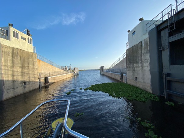
In the morning Ed and I waved goodby to the Lone Cypress and to the Bradleys. Then the craziest thing happened. We were going through the locks at Moore Haven and there was substantial floating vegetation. To my surprise, I saw many marsh rabbits floating on water hyacinth or actually in the water literally up to their ears. We have marsh rabbits at home along the Indian River Lagoon, but I have never seen them in deep water. My emotions got the best of me and I did the unthinkable. I abandoned my post.

“Where is the net?” I shouted as I climbed the stairs leaving the rope hanging against the lock’s tall cement wall. “Ed I’m going to save the drowning rabbits!

Ed was not pleased, yelling, “Jacqui, rule number one, never abandon your post!”

The trawler banged against the lock, the waters rushed in, and I could not reach the bobbing rabbits, so finally I gave up and re-grabbed the line. We passed through the lock into the rim canal of Lake Okeechobee. I silently watched as the rabbits floated by. Ed gave me that look that means he is “not happy.” 

-Marsh rabbit with only ears and face above water -Video of marsh rabbits trapped on floating vegetation below, hit arrow

-After the fiasco at the Moore Haven Locks, Ed and I continued towards Clewiston. We didn’t speak for hours. I actually sat on the bow and cried thinking about how much humankind has altered this planet. But I got ahold of myself. The wind was picking up and many birds were flying overhead -a sign of changes to come.

I checked to see if there was cell service. There was, so I looked up marsh rabbits and to my chagrin, I learned that they are “excellent swimmers.” I looked towards the helm. 

Hey Ed?”

“What?” 

Marsh rabbits can swim!” 

His laugh echoed over the water. “Good thing you didn’t pull them onto the boat!”

“I guess so. But nonetheless, that was NOT NORMAL! ” 

-The rim canal

V. CLEWISTON RIM CANAL/LAKE O 

When Ed and I arrived in Clewiston it was very stormy, we took refuge at Roland Martin Marina. Captain Sam, a war veteran with feathers in his cap, helped us dock. I knew with this weather we’d be here for a few days so I got out my phone and called Clewiston Mayor, Mali Gardner who I’ve known for many years. Over the coming days, she and her husband displayed the warmest hospitality taking Ed and I on a tour of the area. So nice! 

-After docking with the help of Captain Sam, Roland Martin’s Marina, Clewiston-Tour with Mayor of Clewiston, Mali Gardner. We sometimes have different interests, but we have great respect for one another. 

Welcome to Clewiston-Famous Clewiston Inn with wildlife mural-Mayor Gardner shows us the original shoreline of Lake Okeechobee where today many beautiful houses sit-Historic Clewiston homes and drainage system-Ed at the Clewiston Museum that houses the mind blowing fossil findings of Mark Renz from LaBelle-With Mary Anne Martin owner of Roland Martin Marina in Clewison. Ms Martin is a huge advocate for Lake Okeechobee. For years she has voiced against spraying of chemicals on floating vegetation, and works for the burning of lands when lake levels are low to regenerate Lake Okeechobee’s ecosystem. Lake Okeechobee is famous for its bass fishing. -Merchandise for sale and for display at Roland Martin Marina

VI. LAKE O 

-After three days the wind died down and the S-310 lock to Lake Okeechobee was opened. It had been closed for high water for the first time in years. Ed and I headed home to Stuart. Lake Okeechobee was wild and windy, like an ocean itself.  A flock of seagulls followed us 25 miles ! I threw bread from the upper helm and the talented birds, like acrobats, caught pieces in mid air. It was so much fun.

During the trip,  I looked for algae on the lake but saw none and pondered the changes that have altered this liquid heart of the Everglades… 

-S-310 to Lake O-Ed on open Lake O! -Flock of seagulls followed us all the way home across Lake Okeechobee!
This Google Earth image shows our path from Clewiston, across Lake O to the C-44 canal adjacent to Indiantown. The C-44 connects to the St Lucie River bringing us home to Stuart, Florida, in Martin County. 

VII. STUART, C-44 Canal, ST LUCIE RIVER 

S-308 Port Mayaca locks at Lake O to C-44 canal -Trees along the banks of the C-44 CanalS-80 St Lucie Locks and Dam, continuing C-44 to St Lucie River-C-44 is very impaired from Lake O, and basin agricultural and development runoff -After a long journey, a familiar sight, the Roosevelt Bridge opens to welcome us home to the Harborage Marina. Much of the C-44 Canal and upper St Lucie River were under water due to King Tides. This salt infusion is healthy for the St Lucie River as like the Caloosahatchee it is unnaturally connected to Lake Okeechobee.

-Roosevelt Bridges, Stuart, home sweet home back at the Harborage Marina After the almost three week trip, it was wonderful to be home. Ed and I had accomplished our goal and our promise to each other. Working together and experiencing our state’s waters first-hand was a life changing experience.

When we docked with out a hitch like pair of old pros, we  both became strangely quiet. Home is wonderful, but somehow, we knew from here on out, there was nothing that could compare to being Adrift. 


Death by Fertilizer, SLR/IRL

Definition of fertilizer: one that fertilizes specifically, a substance (such as manure or a chemical mixture) used to make soil more fertile so things grow. Usually containing phosphorus and nitrogen.

..

SFWMD 2005

“Death by Fertilizer” or “Our Sick Friends” was originally a booklet created by the River Kidz in 2012 to bring awareness to the ailing health of the bottlenose dolphins in the Indian River Lagoon; I think the message remains a relevant teaching tool today.

Why?

South Florida’s water issues~

~The Lake Okeechobee Watershed: 88% agricultural in nature running into a now sick, eutrophic, algae-ridden, Cyanobacteria filled Lake;  a 700,000 acre Everglades Agricultural Area south of the Lake allowed to back bump when flooding occurs; all this water, in turn, discharged into the ailing St Lucie River and the Caloosahatchee Estuary by the ACOE while the SFWMD and FDEP, and their bosses, the  Executive and Legislative branches of government look on. This putrid, polluted water runs out into the ocean. We think that’s the end of the water destruction, but it’s not, as red tide and seaweed are fertilized, growing into monsters we have never seen before.

Phosphorus Loading by Land Use, Gary Goforth: https://jacquithurlowlippisch.com/tag/phosphorus-loading-by-land-use-what-fdep-isnt-telling-us-gary-goforth/

Septic and sewer pollution is a type of fertilizer too. Some people around the world fertilize their crops with their own human waste; dog poop is also a “fertilizer,” and all this fertilizer leeches or runs off into our estuaries and ends up blending with the polluted Lake O water coming down the pike to the ocean. Every rain event runs right down the storm drains of our neighborhoods and shopping malls with all the “crap” it carries. We designed it that way, years ago, and have not changed this model. The fertilizer put put on our lawns, of course, runs off too.

Yes, it is death by fertilizer that we are experiencing this 2018. Eutrophication, Blooms of algae and cyanobacteria; red tide; too much seaweed suffocating the little sea turtles when they try to come up for air…

The fancy, confusing words of “nutrient pollution” must be replaced with “fertilizer,” something we can all understand. From the time we are children, we learn that “nutrients” are good, they make us strong. Fertilizer can be good, but we instinctively know it can also burn. We know not to eat it; it is not nutritious.  Nutrient Pollution is an oxymoron created by industries and government so we have a hard time understanding what is going on.

In conclusion, fertilizer (phosphorus and nitrogen) from corporate agriculture; poop from animals and people, (mostly nitrogen) and it is feeding, “fertilizing” Lake Okeechobee’s cyanobacteria blue-green blooms that in turn are poured into the St Lucie and Calooshatchee, which in turn this year are feeding, “fertilizing,” tremendous sargassum seaweed blooms, and red tide in the Gulf of Mexico and now in the Atlantic. These blooms are giant multi-celled intelligent, organisms, kind of like a bee-hive. They are hungry and determined and we are feeding them.  It is  a vicious cycle that only we can stop by forcing our government to take charge and coordinate municipal, state and federal programs of education and coordinated implementation. We know what to do.

Developing an effective strategy for reducing the impacts of nutrients, easier understood as “fertilizer over enrichment,” requires all of us to change how we live and the powerful agriculture industry to lead.

Otherwise, it is, and will remain, death by fertilizer.

National Research Council’s book, written in 2000, Understanding and Reducing the Effects of Nutrient Pollution is a step by step guide to this problem: https://www.nap.edu/catalog/9812/clean-coastal-waters-understanding-and-reducing-the-effects-of-nutrient

.

SFWMD 2005

Links:

EPA, Nutrient Pollution: https://www.epa.gov/nutrientpollution/problem

2018 Palm Beach Post, Red Tide:

“Red tide was reported on the east coast in 2007 when it spread to the Treasure Coast south from Jacksonville where LaPointe said discharge from the St. John’s River may have aided its growth. LaPointe said this summer’s plethora of sargassum on southeast Florida beaches could feed red tide with a boost of nutrients leeching into the ocean when the seaweed dies.
Red tide is different from the freshwater blue-green algae, or cyanobacteria, that has spread in Lake Okeechobee, the St. Lucie Estuary and the Caloosahatchee River this summer. But red tide and the cyanobacteria both thrive in nutrient-heavy conditions.
“You have discharges coming out the Jupiter Inlet,” LaPointe said. “Red tide likes the kind of slightly reduced salinity in areas where there’s a river plume.”
https://www.palmbeachpost.com/news/crime–law/new-stretch-beach-jupiter-closed-police-after-odor-sickens-beachgoers/cVD3CBHqrYDrLCFFDV4T7L/

2018 Sun Sentinel, Lake O toxic algae blooms:

“Lake O and Estuaries’ Blooms: Not that this comes as much of a surprise. (Though state leaders feign shock with each new algae outbreak, as if they’ve just discovered gambling in Casablanca.) Environmental scientists have been warning Florida that the watershed lake was an environmental catastrophe since 1969.” Fred Grimm, reporting.
http://www.sun-sentinel.com/opinion/fl-op-column-fred-grimm-lake-okeechobee-algae-returns-20180705-story.html

Close up toxic algae, JTL

2018 Palm Beach Post, Overabundance of Seaweed:

“Palm Beach Post:LaPointe is in the second year of a three-year NASA grant to study how nutrients are changing in the sargassum. What he’s found so far is nitrogen levels have increased, likely from heavy doses of fertilizer and sewage runoff.
“We have altered the nitrogen cycle on our planet and it started with the invention of fertilizer,” LaPointe said. “We think this is what is behind the increased abundance of sargassum.” https://www.mypalmbeachpost.com/weather/why-ugly-thick-brownish-seaweed-cursing-south-florida-beaches/yILMtAMMlxxOXqqYz5H1ZO/

Red tide 2018 #toxic18 site

Plethora of sargassum weed or seaweed at Jensen Beach, 2018 photo Ed Lippisch

Phosphorus Loading by Land Use, What FDEP is not Telling Us, 2018, Gary Goforth: https://jacquithurlowlippisch.com/tag/phosphorus-loading-by-land-use-what-fdep-isnt-telling-us-gary-goforth/

ACOE 2016 Inflows & Outflows/If Only There Were NoFlows…SLR/IRL

150717-A-CE999-051-2.JPG
ACOE Col. Kirk  2015-present

Thank you to John Campbell, Public Affairs Specialist, Army Corp of Engineers, for these numbers comparing “flows” for 2016, 2015, and 2013.  I have been using since last week when presenting and wanted to share. Note, there were no flows (discharges from Lake Okeechobee to the St Lucie River) in 2014 and that is why the year is not reported. The Corp has announced their intent to further decrease flows in the coming weeks as they transition to the dry season. Hurricane, or wet season, comes to an end on November 30th.

All numbers are important but a very important # is how much water is going south…

2016 Flows, JAN 1-OCT 23 (Number of inches based on estimate that 1 foot of Lake O water is about 460,000 acre feet)

Inflows/Rain
Direct Rain 1.85 million ac-ft (48 inches)
Other inflows 3.32 million ac-ft (86 inches)

Caloosahatchee
Moore Haven 1.61 million ac-ft (42 inches)
Franklin 2.39 million ac-ft

St. Lucie
Port Mayaca 630,000 ac-ft (19 inches)
St. Lucie 730,000 ac-ft

South 550,000 ac-ft (14 inches)
Evap/seep/other 1.86 million ac-ft (48 inches)

2015 flows, JAN 1-DEC 31
Inflows/Rain
Direct Rain 1.48 million ac-ft (38 inches)
Other inflows 2.45 million ac-ft (63 inches)

Caloosahatchee
Moore Haven 590,000 ac-ft (15 inches)
Franklin 1.21 million ac-ft

St. Lucie
Port Mayaca 120,000 ac-ft (2 inches)
St. Lucie 190,000 ac-ft

South 1.28 million ac-ft (33 inches)
Evap/seep/other 2.14 million ac-ft (55 inches)

2013 Flows, MAY 8-OCT 21 Inflows/Rain-(Not available at time of request)
Caloosahatchee
Moore Haven 1.02 million ac-ft (26 inches)
Franklin 2.15 million ac-ft

St. Lucie
Port Mayaca 402,000 ac-ft (10 inches)
St. Lucie 663,000 ac-ft

South 166,000 ac-ft (4 inches)

Website:http://www.saj.usace.army.mil

“When Waterways are Polluted Property Values Decline,” SLR/IRL

Economic Impacts
Economic Impacts of polluted water. (EF)

Just last year, Florida Realtors, “The Voice for Real Estate in Florida,” published a final report on the impacts of water quality on Florida’s home values. “March 2015 Final Report.”

The first page of the executive summary states:

“There has long been a belief that there is a connection between home values and the quality and clarity of Florida waterways. The objective of this study was to determine whether that belief is in fact true.

We examined the impact of water quality and clarity on the sale prices of homes in Martin and Lee counties over a four-year period, from 2010-2013. What was clearly found was that the ongoing problem of polluted water in the Caloosahatchee and St Lucie rivers has indeed resulted in a negative impact on home values.

In addition, the study found a significant economic impacts resulting from improved water quality and clarity. Lee County’s aggregate property values increase by an estimated $541 million while Marin County’s aggregate property values increase by an estimated $428 million. These increased property values also provide additional revenue for city and county governments.”

.....
…..

Unfortunately this report, very much like the University of Florida  Report, was basically ignored by the South Florida Water Management District and the state legislature when speakers came before them last year using this document and asking for relief.

As we enter yet another long summer of water pollution, may we re-familiarize ourselves with this report; we are going need to reference it again. Even though this is certainly “common sense,” it helps to have the formal report in hand when speaking.

Here is the full document for your reference. Reading through you will see the story of Lake Okeechobee’s worsening polluting discharges and our property values’ decline.

Full report here: http://www.sccf.org/files/content/docs/FR_WaterQuality_Final_Mar2015.pdf

Lake O Roundtable, Senator Marco Rubio, St Lucie River/Indian River Lagoon

King Aurthur is historically noted for creating the concept of a "round table."
King Arthur is historically noted for creating the concept of a “round table.”

Yesterday, at the Wolf Technology Center, on the campus of Indian River State College, Todd Reid, the Deputy Chief of Staff and State Director for the Office of Marco Rubio oversaw a “Lake Okeechobee Roundtable.” New US Army Corp of Engineers Lt Col. Jennifer Reynolds broke the ice with her introduction, noting she was curious as to whether there would truly be a “roundtable…” She smiled saying she was happy to see the “rectangle-roundtable…” Her comments were funny and refreshing. The point was everyone was sitting around the table—“together,” like in King Arthur’s days….

Agenda, L.O. Roundtable, Office Senator Marco Rubio, 2015

Agenda.
Agenda.

I want to thank Senator Rubio’s office and Senator Rubio himself for the meeting. Could the meeting have been politically motivated? I hope so! Political motivation in any form is the gas that drives the bus. I’ll take it and I’ll hitch a ride….

The meeting was a rare opportunity to sit face to face in a non-charged environment and to listen, to ask questions, to learn, and to get to know each other.

Other than the many Army Corp, South Florida Water Management, and Rubio official leaders that sat at the table, some regional names you might recognize who also were there are:  Comr. Ed Fielding, Kate Parmalee and Don Donaldson, Martin County; Richard Gilmore, Mayor, Sebastian; Dr Jacoby, St John’s River Water Management District; Nyla Pipes; Meagan Davis, HBOI; Mark Perry; Rae Ann Wessel, Caloosahatchee; Jason Bessey, SLC and myself. Sorry if I missed anyone. There were a few some empty chairs with name tags prepared for people who did not make it. Their loss. Of course Gayle Ryan of the River Warriors was in the audience as were others! 🙂 Thank you PUBLIC!

I have written many times, that “building relationships” is what is going to get us beyond the St Lucie/Indian River Lagoon nightmare we live in today. I appreciate the opportunity to build those relationships.

I did learn a lot.

The "Roundtable..."
The “Roundtable…” Photo Jax ACOE Twitter 6-18-15.

One thing I learned again is that the ACOE and SFWMD don’t know how to promote the good things they do. Perhaps this is because they are “government.”

For instance Jim Jeffords, Chief of the ACOE Operations Division noted very quietly that the ACOE under the LORS (Lake Okeechobee Regulation Schedule) this water year had only released 40% of the Lake O water that COULD HAVE gone to the Caloosahatchee River; and only 24% on the water that COULD HAVE gone to the St Lucie.  Holy Cow? Are you kidding me?

I don’t really get the complexities of the entire system, but basically LORS has huge ranges and it gives the ACOE flexibility so they use discretion in determining how much water is actually released rather than just opening the gates to match the number on the chart. So even though they released from Lake O into our SLR since January 16 until a few weeks ago–apparently it could have been worse. —Kind of like when you got  into trouble in my day as a kid and got sent to the office and the principal only spanks you three times when he or she could have spanked you fifteen times. You still walk away crying and humiliated, but it could have been worse….We never thank the ACOE for “not releasing even more,” a lot more, because basically we don’t know that they could….they don’t tell us..they don’t brag. I do; I guess that’s why I’m a “civilian….”

LORS schedule releases SLR 2014 and some of 2015.
LORS schedule releases SLR 2014 and some of 2015.(Photo ACOE Twitter)

And then Jeff Kivett, Divisions Director Operations, Engineering and Construction SFWMD, gave a really nice and erudite presentation with an awesome color copy packet and he just kind of goes right through what for me, if I were him, would have been the most important part: “the SFWMD has sent more than 500,000 acre feet of water south this dry season.” I get this all mixed up like “water year,” “annual year,” dry season, from Lake O, or from the sugar farmer in the EAA, —-in any case for me what’s important is they sent so much water south!

Dr Gary Goforth has written about this and if I remember correctly the most ever sent was in 1995 (like a million acre feet and it killed Biscayne Bay’s reefs) but after 2002 it really slowed to almost “nothing” due to the consent decree’s law suit on phosphorus numbers —but then after 2013’s toxic estuary disaster the SRWMD started sending more water south again. Because now that water is CLEAN due to STAs. (Storm Water Treatment Areas–they are still nervous to send “too much with too much phosphorus…”)

I know I am rambling, but two years ago I remember being happy water sent was over 250,000 acre feet and now the District has sent more than 500,000 acre feet almost two years in a row… This is awesome and to be commended. If I worked at the SFWMD  I would be jumping up and down screaming from the rooftops, but government people just kind of “mention it…..”

Anyway–Good job guys and gals. Good job!

Also, there was also a presentation on the slow but steady-going, expensive repair of the Herbert Hoover Dike by Ingrid Bon, and an update by Howard Gonzales on ecosystem restoration projects. Yes the ones whose names we know by heart that have been taking eight billion years to complete but are actually getting closer! There were also hopeful updates on CEPP (Central Everglades Planning Project) and Ten Mile Creek’s recovery…again very slow-moving like molasses, but moving…maybe….yes….no maybe….YES! How old am I now? Will the projects be done before I am dead? Not funny, but sometime you wonder.

In the end, it was a great meeting and I appreciate that I was allowed to sit “at the roundtable.” It was so good to see Greg Langowski who I have known through Rubio’s office since my early days in the Treasure Coast Council of Local Governments, as well as my dear friend mayor, Richard Gilmore of Sebastian! We are all getting older, but  wiser too, and if we stick together, we just might make a difference for the St Lucie River/Indian River Lagoon, and for the kids of the future that just want to fish, swim and boat in the river and just be a “kid.”

Thank you for the Roundtable Senator Rubio. I hope there will be more…

Great visual from Jeff Kivett's presentation on changes to the Everglades system.
Great visual from Jeff Kivett’s presentation on changes to the Everglades system.

Getting the Numbers Straight With U.S. Sugar, SLR/IRL


This pie chart shows an average of Lake O discharges in acre feet to the estuaries from 1996-2015. (Dr Gary Goforth 2015)

After last Thursday’s WRAC meeting at the South Florida Water Management District, I left somewhat miffed.

(http://www.sfwmd.gov/portal/page/portal/xweb%20about%20us/meetings)

The numbers seemed wrong….

These meetings are difficult to follow, and almost surreal at times.  On Thursday, this was especially true with “paid” protesters yelling outside against the option land purchase, and afterwards the group’s slick sun-glassed/suit-wearing organizer coming inside to pat one of the WRAC members on the back.

I sat there thinking “life really is stranger than fiction,” no wonder south Florida satirist and writer Carl Haaisen says almost all of his material is “simply out of the newspapers…”

Another oddity for me was when Bubba Wade, representing US Sugar Corporation, during WRAC members’ comments referencing “2013,”  in defense of not purchasing the option lands, quoted the acre footage of water to the St Lucie Estuary/IRL as “4.5 million acre feet annually,” —and thus justifying that if the 26,000 acre option lands located south of the lake were purchased, even with that water “exchanged,” it would never be “enough…”

I’m thinking to myself: “445,000—4.5 million…I saw  “that” number in a Palm Beach Post article too, but I swear it said billion and not million acre feet….where are these numbers coming from? Is Bubba using the right numbers? I think they are wrong….Am I wrong?”

After the meeting, I even walked up to Mr Wade, who I have met on many occasions and feel I have a good working relationship with saying: “Bubba, where did you get your numbers?  I am almost sure the St Lucie River, no maybe the estuaries received around 1.5 million acre feet of water in 2013, not 4.5 million acre feet to the SLR. What are the numbers? If we can’t agree on what numbers we are talking about, how we ever agree on anything at all? ”

Bubba was talking out loud trying to figure where he got his numbers, and I was wondering where I got mine as well…in the end we just stared at each other…

When I got home I consulted Dr Gary Goforth. I have interpreted and put into laymen terms what he wrote to me below.

It shows that the numbers change depending on what years one is talking about, and over how long a period of time.

First of all…. : For calendar year 2013, 1.584 million acre feet of Lake water was sent to the estuaries… The St Lucie gets about 20% of that…. But in figuring out “distribution,” one does not just look at one year….Dr Goforth shared again his hand out from last month’s SFWMD Governing Board meeting:

The chart below shows in acre feet, the “distribution of Lake Okeechobee releases from  water years 1996-2015.” “20 years” of reference, gives a more accurate estimate of the long-term average of annual values than a shorter time period. Of course every year annual flows vary. For years 1996-2015 the average number of acre feet to the SLR/IRL  is 270, 224.

This pie chart shows an average of Lake O discharges in acre feet to the estuaries from 1996-2015. (Dr Gary Goforth 2015)

This chart, taken from the ACOE and SFWMD and shown here in a slide presentation by Mark Perry of Florida Oceanographic, shows a 10 year period from 1996-2005.

The above chart is different as it shows a ten-year, not a twenty-year average, 1996-2005). Here the number, 442,000 looks more like  Bubba’s 4.5 million acre feet. (I found this chart in Mark Perry’s presentation on his website at Florida Oceanographic.)This must be the chart Bubba Wade was referring to…?

Which number is better? Which number is correct? That depends what one is trying to prove. Right? 🙂

In any case, when quoting numbers, it is good to know which reference chart one is quoting. One one should also reference which chart one is using….This goes for me as well as for Mr Wade of U.S. Sugar….

Heading of Dr Goforth's chart showing estimated releases from Lake O to SLR from 1931-2013.
Heading of Dr Goforth’s chart showing estimated releases from Lake O to SLR from 1931-2013.

A section of Dr Goforth's chart 1988-2013.
A section of Dr Goforth’s chart 1988-2013. Years 1988-2013 showing acre feet flows from Lake O to SRL.

Lake Okeechobee conversion sheet, Everglades Coalition break out session, 2015.
Lake Okeechobee water/conversion sheet, Everglades Coalition break out session, 2015.

_______________________________

WRAC, SFWMD, (http://www.sfwmd.gov/portal/page/portal/xweb%20about%20us/wrac)

Mr Malcom (Bubba) Wade, US Sugar Corporation, (http://www.ussugar.com/press_room/bios/wade_bio.html)

Dr Gary Goforth: (http://garygoforth.net)

Florida Oceanographic/Mark Perry’s power point presentations: (http://www.floridaocean.org/p/233/advocacy-environment#.VSKHyrrRwl8)

_____________________________________

This photo is to reference a comment on this blog:

Page 16 of Jeff Kivett's System constraints document, SFWMD, 2015 as shown to respond to blog comment. 4-7-15
Page 16 of Jeff Kivett’s System constraints document, SFWMD, 2015 as shown to respond to blog comment. 4-7-15

This is THE photo where the 4.5 million acre feet comes from. Thank you to Christine Stapleton of the Palm Beach Post for sharing when I asked where she got her sources for her article referred to in comments in this blog post.  THE PROBLEM with the slide is that this is referring to ALL WATER into the estuaries: "local runoff" and Lake Okeechobee water. This conversation is not about ALL WATER/"LOCAL" runoff water---it is about Lake Okeechobee and how the ACOE and SFWMD make us take this water that IS NOT  OURS. The 4.5 M number makes it sound like it is not possible to fix lake O. This is untrue. IT is fixable at 1.5 million acre feet or even twice that much. If nothing else the issue could be alleviated.
4-7-15: This is THE source where the 4.5 million acre feet comes from. (Jeff Kivett’s SFWMD constraints doc.) Thank you to Christine Stapleton of the Palm Beach Post for sharing when I asked where she got her sources for her article referred to in comments in this blog post. THE PROBLEM with the slide is that this is referring to ALL WATER into the estuaries: “local runoff” and Lake Okeechobee water. This conversation, this blog post, the land purchase south of the lake,  is not about ALL WATER/”LOCAL” runoff water—it is about Lake Okeechobee water and how the ACOE and SFWMD make us take this water that IS NOT OURS. The 4.5 M number mentioned by Mr Wade or Ms Stapleton makes it sound like it is not possible to “fix” lake O, or to buy enough land that would help the estuaries or hold clean, and convey water,. This is untrue. It is “fixable” at 1.5 million acre feet or even twice that much. If nothing else the issue of lake O being the toxic nail in our estuaries could be half way alleviated. 

“How to Speak About Overcoming Constraints,” SFWMD, St Lucie River/Indian River Lagoon

Possibilities Rather Than Constraints…

Jeff Kivett attended Colorado State University ; worked for 7 years in "water starved" Los Angeles; and now lives with his family  in Martin County, working in a leadership capacity for the SFWMD.(Photo SFWMD public files.)
Jeff Kivett attended Colorado State University; worked for 7 years in “water starved” Los Angeles; and now lives with his family in Martin County, working in a leadership capacity for the SFWMD. (Photo SFWMD public files.)

Slide 1 of the SFWMD power point presentation "Constraints to Sending Water South, 2015.)
Slide 1 of the SFWMD power point presentation by Jeff Kivett, P.E. SFWMD,  “Constraints to Sending Water South, 2015”.)

Regarding the outdated and failing water system of South Florida—of course there are “constraints.”

Everything in our material world is a “constraint,” but because we are human beings, creative and determined, we can “overcome” our constraints. ——but in order to do so, one must understand the “constraints” in the first place. Therefore, thank you to Jeff Kivett, P.E. Operations, Engineering and Construction Division Director, South Florida Water Management District, who created a recent power point on the subject. (http://www.sfwmd.gov/portal/page/portal/xrepository/sfwmd_repository_pdf/wrac_pres_system_constraints_2015_0205.pdf)

(http://www.sfwmd.gov/portal/page/portal/xrepository/sfwmd_repository_pdf/kivett_bio.pdf)


Slide 1 of the SFWMD power point presentation "Constraints to Sending Water South, 2015.)
Slide 1 Close up.

Recently US Sugar Corporation, and even some members from the Governing Board of the SFWMD itself , (http://www.sfwmd.gov/portal/page/portal/xweb%20about%20us/governing%20board “hijacked” Mr Kivett’s document, to make it seem like it proves everything is “in stone,” justifies the atrocities of the plumbing system, and makes the idea of buying land south of Lake Okeechobee null and void….Nothing, could be further than the truth….and was not the intension of Mr Kivett’s document.

(http://www.sfwmd.gov/portal/page/portal/sfwmdmain/home%20page)

The way I see it, and after talking to Mr Kivett myself, he has given us a map “of flight.” A map for us to learn and understand how to overcome our present limitations. I am grateful to him for the map, and I will use it not to keep things the same, but to promote change. 

________________________

Today I am going to share a document written by my friend Dr Gary Goforth. Dr Goforth (http://garygoforth.netand I took Mr Kivett’s document and wrote about each “constraint” in such a way as to understand how to overcome it.

Please read, learn and speak out about it —- thank you for working to be part the solution and inspiration to “overcome,” the failures of the present South Florida system so that in the future it does not only provide flood control, but also provides even more clean, fresh water to the Everglades, and to South Florida, and  no longer kills two of the most productive and economically important estuaries in North America, the St Lucie/Southern Indian River Lagoon and the Caloosahatchee.

St Lucie Inlet area near Sailfish Point, 2013, JTL)
St Lucie Inlet area near Sailfish Point, once the most bio-diverse fishing and breeding grounds in North America- Grant Gilmore. (Photo 2013, JTL)

Photo of plume from Lake O and area canals in 2013, Jupiter Island. Our present pulling system constraints unless changed will promote this indefinitely. (JTL)
Photo of plume exiting SLR/IRL at St Lucie Inlet–dark water is mostly from Lake O  and is flowing over protected near shore reefs towards Jupiter Island, affecting some of  the most expensive real estate in the country. S. Florida’s present pluming system “constraints,” unless changed,  will promote this destruction indefinitely. (JTL)

The waters of the St Lucie fill with algae, sometimes toxic, during heavy release from Lake O. (Photo Jenny Flaugh 2013.)

Toxic algae, photo by Mary Radabaugh of St Lucie Marina.)


Please use the map to refer to the numbers from top to bottom.

Slide 1 of the SFWMD power point presentation "Constraints to Sending Water South, 2015.)
Jeff Kivett’s slide summarizing present “constraints.” Most can be overcome.


______________________________________________________

Identifying and understanding system constraints is a fundamental step in identifying long-term solutions to minimizing destructive Lake releases to the estuaries.   Many constraints represent short-term, i.e., daily or weekly, restrictions, and are not absolute limitations to achieving long-term goals.   With proper planning, interim goals can be achieved in light of these short-term restrictions. Compiling the system constraints is particularly important to identifying long-term solutions for sending additional Lake water to the Everglades and minimizing destructive releases to the estuaries. A properly constructed “System Constraints” document provides fundamental engineering justification for the State to purchase available lands within the EAA in order to add to the storage and treatment necessary to achieve this long-term goal.


  1. Herbert Hoover Dike around Lake Okeechobee is a “dynamic constraint” since its importance in decision making is related to the time of year, the water level in Lake Okeechobee, and its structural integrity. At low water levels, the dike is not necessarily a constraint. Parts of the dike were constructed in the 1930s, and concerns over its structural integrity led to lowering the overall regulation schedule to the current interim operating schedule (LORS2008). It will be possible to hold more water in the lake, thus reduce the destructive discharges to the estuaries, as the U.S. Army Corps of Engineers continues the rehabilitation. The Corps has already spent $650 million in rehabilitation and they should speed this process up as fast as possible.


  1. Lake Okeechobee Regulation Schedule or LORS provides guidance on how much Lake water goes south and how much goes to the estuaries. The flexibility provided to the District and Corps to make lake operations decreases as lake water levels drop too low or rise too high, and as such, is also a “dynamic constraint.” LORS takes into consideration many factors, including the integrity of the Herbert Hoover Dike, the ecology of the lake ecosystem, and water supply needs of adjacent landowners. The current LORS (“LORS2008”) was developed in 2008 as an interim schedule in response to concerns about dike safety, and it is possible for it to be “reworked.” In light of the $650 million in rehabilitation work on the dike, the SFWMD could press for the Corps to revise LORS to provide greater storage in the Lake and reduce the destructive discharges to the estuaries. Senator Negron, Congressman Murphy and US Senator Rubio also have been breeching this subject. The Corps says that LORS will probably not be reworked until HHD is “fixed.” Another good reason to speed that up.


  1. Structure Capacity: “Structure capacity” refers to the amount of water that can be sent south during a relatively short timeframe (e.g., a day or a week) through the spillways and culverts located around Lake Okeechobee. The total structure capacity varies depending on Lake level and EAA canal level, allowing for different amounts of water to be sent south during different times of the year.  Water control plans for regions like the EAA are developed to achieve long-term goals in recognition of short-term structure capacities. FYI: It is best to send water south all year round, especially in the dry season when the stormwater treatment areas (STAs) and Everglades need water at the same time the Lake water levels need to drop for the health of the Lake ecology and in anticipation of the upcoming wet season.  Alternatives for minimizing estuary discharges that send additional Lake water south recognize this constraint, and include increased numbers and capacity of the structures along Lake Okeechobee.


  1. Canal conveyance capacity refers to the rate at which water can flow through a canal. During storm events, the EAA canals are used primarily to provide flood protection, however, these canals are not needed for flood protection every day of the year, and their capacity can then be used to deliver Lake water to the south. For this reason, canal conveyance capacity is not a fixed constraint in the context of making year-round deliveries of Lake water to the south. The canals could be enlarged to allow more water to go south. In addition, canal conveyance capacity could be increased as part of a flow-way/reservoir system constructed in the EAA on purchased option lands. This should be a goal with the new Amendment 1 funding.


  1. Species Protection. As water levels drop within the STAs during the dry season, migratory ground nesting birds (e.g., black necked stilts) and protected species (e.g., snail kites) find it conducive to build their nests. Once they nest in an STA, restrictions to protect the nests are put into place which severely limit the amount of water that can be sent through the STA. To discourage this nesting, the STAs’ Avian Protection Plan encourages a minimum depth of 6 inches. Achieving this operational guidance is a secondary benefit of treating Lake water in the STAs during the dry season. As an example, the only STA-5/6 with nesting snail kites at this time is STA-5/6 – coincidently the only STA that has not received Lake water.


  1. STA Treatment Capability. Overloading the treatment areas with nutrients from the EAA and Lake Okeechobee can adversely affect the ability of the STAs to optimally reduce phosphorus levels. However, as Lake water was delivered throughout the year at a relatively low rate, treatment performance has not diminished. In fact, STA performance has improved concurrent with the sustained delivery of historic large volumes of Lake releases to the south in a year-round operation. Over the last year, the outflow phosphorus concentration from STA-1E, STA-1W, STA-2 and STA-3/4 improved by 4 parts per billion (ppb), decreasing from 21 ppb to 17 ppb. The only STA that has not exhibited a performance improvement was STA-5/6 which did not receive any Lake water. In addition, District scientists indicate there have been no adverse impacts on the treatment vegetation due to Lake water.


  1. Pump Capacity: With the construction of the STAs, there is now more capacity to remove EAA floodwaters than ever before. This extra pumping capacity has also been used in the last year to significantly increase the delivery of Lake water to the Everglades. Many of the STA pumps are quite large and are not run 24/7. If smaller pumps can be built, additional Lake water could to be sent south “all day and night.”  Amendment 1 funding could be used to construct additional pumps, purchase lands and build additional STAs or other features.


  1. STA 5/6 Connectivity: There are 5 STAs, and STA-5/6, located in Hendry County, is the only STA that has not received Lake water in several years. This STA has the poorest performance of the STAs and is currently the only STA with nesting Snail Kites, which places strict limits on allowable water depths within the STA. While a physical connection exists between the Lake and the STA, the associated operations are complicated. Improving the connection to the Lake should be a priority so even more Lake water can be sent south while providing hydrologic benefits to the STA.  Portions of STA-5/6 can be sent directly to the northwest portion of WCA-3A, an area that needs Lake water to keep from drying out, without passing through the EAA canals.


  1. Wildlife Management Areas: Over 60,000 acres of public lands lie between the EAA and the lake, and water levels are managed to improve remnant Everglades habitat and are very important to wildlife. These areas are not being used to store and treat additional Lake water, and could be used to do so during the temporary periods of emergency releases from the Lake. The current operating schedule attempts to maintain water depths between 0 and 1 foot deep, which also provides suitable habitat for game hunting. The hunting community is our friend and we need to ask them for help during these temporary periods of emergency Lake releases.


  1. Water Level Limitation (Tree Islands & Wildlife): These areas, too, are very sensitive as the tree islands are sacred to our state’s native peoples/they are protected. The animals get on them when water is high to stay safe. It is only possible to send more water around them if it does not hurt the integrity of the tree islands. We should maintain good relationships with our native American friends; they have huge water problems too. Delivering treated Lake water to the WCAs throughout the year (not just during the wet season) and increasing out flows from the WCAs along the Tamiami Trail will help protect the remaining tree islands.


  1. LEC (Lower East Coast Canal Conveyance): These are canals that move local floodwaters and Lake O water east to replenish drinking water wellfields and send excess water into the Atlantic. They could be enlarged to increase their conveyance, although it would be better not to waste this water to the ocean, and instead, keep it within the south Florida system. As sea levels rise, additional Lake water will be needed to stave off saltwater intrusion in the coastal wellfields.


  1. Levee Safety: This earthen levee was built along the eastern boundary of the water conservation areas (WCAs) and keeps water from going into developed areas along the east coast. The safety of these levees places a constraint on the water depths within the WCAs. Water depths within the WCAs are a function of rainfall, evaporation, seepage and the movement of water into and out of the WCAs. Delivering treated Lake water to the WCAs throughout the year (not just during the wet season) and increasing out flows from the WCAs along the Tamiami Trail will help maintain safe water levels.


  1. Flow Limitation: The Tamiami Trail blocks the flow of water south into the Everglades National Park; more openings are being installed to increase this flow, and more could be put in for the future. Stringent limits of phosphorus are in place along the Tamiami Trail, and the State and Federal governments are currently discussing potential appropriate revisions. For the most recent year, the geometric mean of phosphorus was 5.6 ppb – well below the 10 ppb criterion.


  1. Flood Risk (G3273, South Dade Conveyance System): This area is around the city of Homestead, adjacent to the Everglades National Park.  Right now they are having serious high-groundwater issues, stemming from the desire to hold higher water levels in Park. This is being studied and groundwater levels may be exacerbated with sea level rise. Potential solutions include construction of a cut-off wall to minimize seepage from the Park.


*The bottom line is that resolving “constraints” is only limited by our will and imagination and they should not be presented as “unchangeable.”


The River Kidz’ Second Edition Workbooks are Here, Our Mission’s Quite Clear! SLR/IRL

River Kidz' Second Edition Workbook, presented by Marty the Manatee is here!
1.River Kidz’ Second Edition Workbook, 2015, presented by Marty the Manatee, is here!

River Kidz is a division of the Rivers Coalition: (http://riverscoalition.org)

2-2-15: ELECTRONIC COPY via TC Palm: http://shar.es/1oqnzM

_______________________________________

The first verse of the River Kidz’ Song, written by River Mom, Nicole Mader, and the River Kidz goes:

“The River Kidz are here; Our mission’s quite clear; We love our river and ALL its critters; Let’s hold it all dear…”

The rest of this wonderful song can be found on page 36 of the new workbook below.

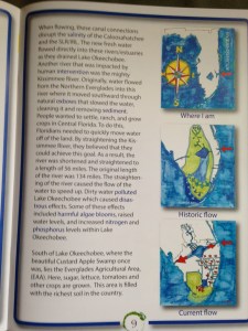
After over a year of creative preparation, and community collaboration, the River Kidz’ 2nd Edition Workbook is here!

After long contemplation this morning, I decided to share the entire booklet in my blog; but as WordPress, does not accept PDF files, I have photographed the entire 39 pages! So, not all pages are perfectly readable, but you can get the idea.

The really cool thing about this workbook is that it was written “by kids for kids,” (Jensen Beach High School students for elementary students). The high school students named the main character of the book after Marty Baum, our Indian Riverkeeper.  The students had met Mr Baum in their classroom (of Mrs Crystal Lucas) along with other presenters and field trip guides like the Army Corp of Engineers, South Florida Water Management District, and politicians speaking on the subject…

The books will be going into all second grade public school classrooms and many private school classrooms beginning in February of 2015. Teacher training  will be underway this February at the Environmental Studies Center in Jensen: (https://www.facebook.com/escmc?rf=132947903444315)

River Kidz will make the booklet available to everyone. Some will be given away, and some will be used to raise money at five dollars a booklet. To purchase the booklets, please contact Olivia Sala, administrative assistant for the Rivers Coalition at olivia@riverscoalition.org —-Numbers are limited.

In closing, enjoy the workbook and thank you to Martin County, Superintendent, Laurie J. Gaylord for encouraging the workbook and for her  beautiful  letter in the front of the booklet. Thank you to Martin County School Science Leader, Valerie Gaylord; teacher, Mrs Crystal Lucas; Mom, Mrs Nicole Mader; Sewall’s Point artist, Ms Julia Kelly; Southeastern Printing’s Bluewater Editions’ manager and River Dad, Jason Leonard; to River Kidz founders Evie Flaugh and Naia Mader, now 14/13; years old–they were 10 and 9 when this started,—- to the Knoph Foundation, and the Garden Club of Stuart, and to the hundreds of kids, parents, students, businesses, politicians, state and federal agencies, and especially to Southeastern Printing and the Mader Family who made this concept a reality through education, participation. (Please see page 34 below.)

Thank you to all those who donated money for the workbook campaign and to River Kidz over the years, and to the Stuart News, for Eve Samples’ column, and reporter, Tyler Treadway, for including the River Kidz in their “12 Days of Christmas” for two years in a row.  River Kidz is grateful to everyone has helped…this is a community effort!

River Kidz is now in St Lucie County and across the coast in Lee County….

Remember, all kids are “River Kidz,” even you!

—-The workbook is in loving memory of JBHS student, Kyle Conrad.


2.
2.

3.
3.

4.
4.

5.
5.

6.
6.

7.
7.

8.
8.

9.
9.

10.
10.

11.
11.

12.
12.

13.
13.

14.
14.

15.
15.

16.
16.

16.
17.

18.
18.

19.
19.

20.
20.

21.
21.

21.
22.

23.
23.

24.
24.

25.
25.

26.
26.

27.
27.

29.
28.

29.
29.

30
30.

31.
31.

32.
32.

33.
33.

34.
34.

35.
35.

36.
36.

37.
37.

38.
38.

39.
39.

Cities Addressing Florida’s Water Problems Together, Tuning the Tide, St Lucie River/Indian River Lagoon

The Florida League of Cities advocates the Florida legilature on behalf of the majority of Florida's 410 municipalities.
The Florida League of Cities advocates the Florida legislature on behalf of over 400 Florida municipalities.

Today I would like to share good news from the Florida League of Cities of which I have been an active member, as an elected official of the Town of Sewall’s Point, since 2009. I was also fortunate to be chosen to chair the league’s environmental committee last year in 2013 and in 2013 the SLR/IRL became a part of the leagues legislative priorities. Today I am happy to share continued support by the FLC regarding  the plight of the St Lucie River/Indian River Lagoon and Caloosahatchee River due to excess polluted discharges from Lake Okeechobee.

Only a few years ago, the league had never heard of the St Lucie River/Indian River Lagoon, and thanks to last year’s public outcry and the leadership of Senator Joe Negron, and others, today we are part of their greater lobbying effort!

To give some background, the Florida League of Cities is the “united voice” for Florida’s municipal governments and was first started in 1922.  Its goals are to serve the needs of Florida’s cities and to promote local self-government and Home Rule. The league was founded with the idea that local self-government is the keystone of American Democracy. Today there are over 400 municipal members, (towns, cities, villages) represented by the league. (http://www.floridaleagueofcities.com)

Florida League of Cities Legislative Committeee
Florida League of Cities Legislative Committee, 2014. (Photo Jacqui Thurlow-Lippisch)

Regionally,  the Town of Sewall’s Point, City of Stuart, Town of Ocean Breeze, Town of Jupiter Island, St Lucie Village, City of Port St Lucie, Ft Pierce, Fellsmere, Sebastian, Vero Beach and Okeechobee are active members of the league. 

There are five legislative committees of the league and ten priorities come out of each legislative session based on the work of the legislative committees that comprise members from all over the state with as many as 50 members sitting on a committee. This year’s Legislative Committee for the FLC occurred November 12-14 in Orlando.

The committees are as follows: Energy, Environmental and Natural Resources; Finance and Taxation; Growth Management and Economic Affairs; Transportation and Intergovernmental Relations; and Urban Administration.

Sam Henderson 2014 Chair for the EENR Committee, presenting with FLC's Ryan Matthews.
Sam Henderson 2014 Chair for the EENR Committee, presenting with FLC’s Ryan Matthews.

As I mentioned, I chaired the Energy and Environmental and Natural Resources Legislative Committee last year, but this year did not, and I was wondering if estuaries of the SLR/IRL and Caloosahatchee would take a back seat as there is fierce competition and many water problems throughout the state.  I was delighted to see that the committee continued its commitment to calling attention on a statewide level to the water problems of our region.

The POLICY STATEMENT for Water Quality and Quantity 2014 reads:

The Florida League of Cities supports legislation that provides recurring allocations of financial resources for local government programs and projects resulting in the protection of water resources, the improvement of water quality and quantity, and the expanded use of alternative sources of water.

The background immediately following this priority is even more specific stating:

Florida is currently dealing with multiple water challenges. South Florida faces water quality problems in the form of massive water releases of nutrient enriched waters. Those releases, which are controlled by the Army Corp of Engineers–a federal agency, pollute the estuaries and water systems that flow to the St Lucie on the east and the Caloosahatchee on the west.  North Florida faces an impending disaster in its oyster industry due to increased water usage by neighboring states Alabama and Georgia. Meanwhile all of Florida is struggling with how to efficiently conserve water and avoid devastation to the Florian Aquifer….

I am thankful to the league and to the many elected officials from all parts of our state who supported this legislative policy statement for 2014. This statement will go before the state legislature as the league lobbys and works for policies of the league.

We must be mindful of all of our water issues, from spring degradation, dying lakes and rivers, aquifer depletion, as well as the St Lucie/Indian River/Caloosahatchee/Lake Okeechobee issues we deal with at here home.

Understanding all of our water issues together is necessary, as we are all connected.

Together as cities fighting for what we love, our cities, we can overcome the common apathy of our state legislature and the destruction that has been brought upon our state by overdevelopment and lack of appreciation of our natural systems and the role they play in strong economies and quality of life.

With cities addressing Florida’s water problems together, we just might turn the tide….

Caloosahatchee River, A Cub Club Fly-In, St Lucie River, Indian River Lagoon

Caloosahatchee River.
Caloosahatchee River, courtesy of the CRCA.

THIS ARTICLE WAS WRITTEN FOR MR LARRY ROBINSON AND HIS “CUB CLUB” THAT WILL BE FLYING INTO HISTORIC BUCKINGHAM FIELD AIRPORT CLOSE TO THE CALOOSAHATCHEE RIVER IN LEE COUNTY; I THOUGHT THIS MIGHT BE OF INTERESTS TO ALL.

Cub Club
Cub Club of Florida

When flying into Buckingham Airport near Ft Meyers, one will surely get a view of the beautiful Caloosahatchee River that runs from Lake Okeechobee to the Gulf of Mexico.

The river, named after the warlike Calusa Indians,  has a great history and is unfortunately under great pressure due to man-made changes in its surrounding hydrology. The original lands of the watershed allowed for the waters of the Kissimmee Valley,  near Orlando, to move south through the then winding Kissimmee River, into Lake Okeechobee,  and then slowly make their way to the Florida Everglades. 

Historic flow of Lake Okeechobee
Historic flow of Lake Okeechobee. (Map courtesy of Everglades Foundation.)

Before the late 1880s, the Caloosahatchee was not truly connected to Lake Okeechobee; its headwaters started at Lake Hicpochee, west of today’s Clewiston. Marshlands filled from Lake Hicpochee to Lake Okeechobee in times of heavy rain “connecting” the waterway but this was not lasting.

In the late 1800s investor and land owner, Hamilton Disston, following an old Calusa Indian canal, connected the river permanently to Lake Okeechobee by digging a wide canal. This was done in order to drop the level of the lake and drain the surrounding lands for agricultural development.

Disston was not completely successful but he did inspire others to complete his work in the early 1920s.

redirection of the waters of Lake Okeechobee through the Caloosahatchee and St Lucie Estuaries.
Redirection of the waters of Lake Okeechobee through the Caloosahatchee and St Lucie Estuaries. (Map courtesy of Everglades Foundation.)

People had been farming in Florida south of the Lake Okeechobee since the late 1800s as the muck was very rich and produced wonderful crops. But flooding was a constant issue.

After the horrific hurricanes of 1926 and 1928 that completely flooded the area south of the lake and took thousands of lives, the state of Florida begged the federal government for flooding assistance which resulted in the Cross State Canal being built from Ft Meyers to Stuart and the building of the Herbert Hoover Dike around southern Lake Okeechobee.

The canal allowed not only for east west navigation across the state, but also redirected the waters of Lake Okeechobee that traditionally flowed south to be sent east and west through nearby estuaries:  the Caloosahatchee on the west and the St Lucie River/Southern Indian River Lagoon on the east.

After another great storm and flood in 1948, and repeated outcry of the state and public, the Army Corps of Engineers “improved the system” through the Central and South Florida Project by widening and deepening already constructed canals and by building many more. 

By the 1960 the Everglades Agricultural Area (EAA), south of the lake, became the number one sugar and vegetable producer of the state and one of the top in the nation; fortunes were made in the post-wartime era.

Simultaneous to the success of the EAA, development exploded along the two estuaries, the Caloosahatchee, and St Lucie/Southern Indian River Lagoon. Both of these areas depended heavily on fishing, tourism, and real estate values for their economies so when Lake Okeechobee would overflow and billions of gallons of fresh water would pour into the estuaries disturbing the brackish balance, killing seagrasses, destroying fishing stock and wildlife, of course these cities along the coasts complained.

Over time, even more people have moved the Caloosahatchee and St Lucie areas, and the massive population of Orlando has complicated the situation as “Orlando’s”  polluted water full of nitrogen and phosphorus from fertilized lawns and farmlands travels south filling Lake Okeechobee. Since the water cannot go south, it is redirected to the estuaries. As a result, the Caloosahatchee and St Lucie estuaries experience toxic algae blooms during heavy destructive discharges. 

This “health and safety” situation came to a head recently during the summer of 2013 when the Army Corps released from Lake Okeechobee for five months straight: May 8th- October 21st. This time became known as the “Lost Sumer” as health departments warned citizens and pets to stay out of the water for months on end.  

 Due to public outcry,  Florida Senator Joe Negron, chair of the Appropriations Committee, organized a “Senate Hearing on the Indian River Lagoon and Lake Okeechobee Basin” that included studies of both estuaries. Congressman Patrick Murphy invited citizens to Washington DC.

The east and west coasts and many politicians unified during this time, thousands rallied, and news of the toxic waters was told by local, state, national and global media.

The Florida governor, state legislature, US Congress,  along with “water managers,” Army Corp of Engineers and the South Florida Water Management District, felt tremendous pressure to find alternative ways to store water and clean water north of the lake and to “send more water south.” 

Under the 2013/14 state legislative sessions the state legislature and federal government designated monies for both estuaries to help abate these issues. Part of the Tamiami Trail was even “opened” to allow more water to flow south and plans are being made to lift and open more areas in the future. University of Florida water experts are studying the issue.

Unfortunately, in spite of what can be done, this  is just the tip of the iceberg as the amount of water that needs to be redirected away from the estuaries is enormous, truly beyond comprehension. This is why many believe Everglades restoration plans are taking entirely too long and that we must find a way to fully restore the Kissimmee River and create a third outlet south of the lake.

_______________________________

South Florida Water Management District: Caloosahatchee River: (http://www.sfwmd.gov/portal/page/portal/xweb%20protecting%20and%20restoring/caloosahatchee%20strategies)

Dept of Environmental Protection: Caloosahatchee River or C-43: (http://www.protectingourwater.org/watersheds/map/caloosahatchee/)

Caloosahatchee River Citizen’s Association, CRCA: (http://crca.caloosahatchee.org/about/?show=legacy)

Central and South Florida Project: (http://www.evergladesplan.org/about/restudy_csf_devel.aspx)

Images of Toxic Algae Blooms Caloosahatchee River: (http://www.bing.com/images/search?q=toxic+algae+blooms+caloosahatchee+river&qpvt=toxic+algae+blooms+caloosahatchee+river&FORM=IGRE)

ACOE Everglades Restoration: (http://www.evergladesplan.org)

The History, the Future, of Plan 6 and “Sending Water South,” St Lucie River/Indian River Lagoon


plan 6 prototype
Map for the “Performance Configuration” co-authored in 2009, incorporating Plan 6 ideas for sending more water south.

First thank you to Dr Gary Goforth for providing much of this historical data.(http://garygoforth.net)

There is a lot of controversy surrounding the idea of “sending water south,” mostly because in order to do so privately owned lands would be taken out of sugar productivity. This post is meant to share some of the history of ideas over the years to do so, not debate it.

As we all know, before the lands south of Lake Okeechobee were drained for the budding agriculture industry in the late 1800s onward, when Lake Okeechobee overflowed, ever so gently its waters ran over the southern lip of the lake through a pond apple forest, creating a “river of grass” that became the Everglades.

In the 1920s at the direction of Congress and the State of Florida the Army Corp of Engineers (ACOE) redirected these overflow waters that had functioned as such for thousands of years through canals C-44 to the St Lucie River and C-43 to the Caloosahatchee.

This achieved better flood control for agriculture and development but has caused an environmental disaster for the northern estuaries and for the Everglades.

The environmental destruction and safety issues of the Herbert Hoover Dike were noted early on.  As far as the destruction of a local industry, the fishing industry in the St Lucie River was the poster child.  This and many other reasons caused many people over the years to seeks “improvements,” to the  overall ecological system.

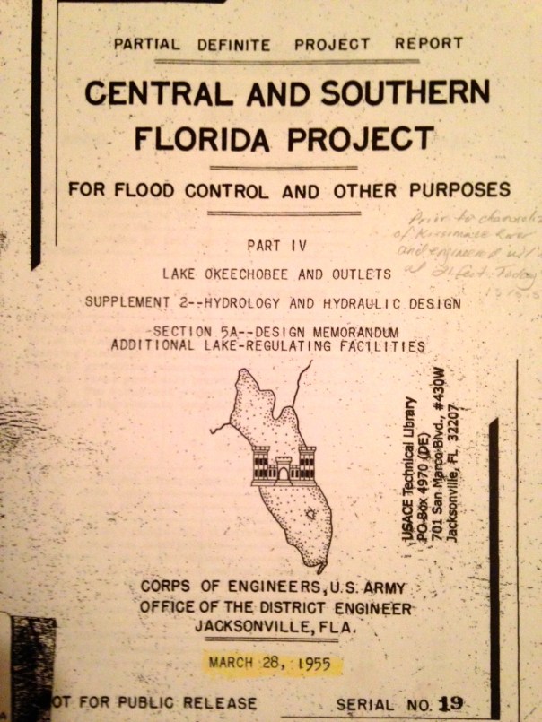
One of the first was the 1955 ACOE Central and Southern Florida Project Part IV. It was a proposal evaluating different options (plans) for “increasing lake outlet capacity.  One component was “Plan 6,” a one mile wide floodway extending from the Herbert Hoover Dike to one mile into Water Conservation Area 3. For this report, Plan 6  was  the recommended improvement.  Dr Gary Goforth notes discharges to the St Lucie would have been lessened about by half,  but “not eliminate lake discharges to the St Lucie River.” In the end, the entire plan was not acted upon as many tax payer paid plans are not…but Plan 6 was not forgotten…

photo 1
Photos taken of 1955 ACOE CSFP Report courtesy of Dr Gary Goforth.

photo 5
Floodway 1955

photo 3 photo 2

Various references to Plan 6 and a floodway.

Dr Goforth also notes a “more robust plan,”a plan co-authored in 2009 by Karl Wickstrum, Paul Gray, Maggy Hurchalla, Tom Van Lent, Mark Oncavgne, Cynthia Interlandi, and Jennifer Nelson. (See first photo in this blog.) This plan is referenced by Mark Perry in his well known “River of Grass” presentation.

Plan 6
Mark Perry’s drawing in his presentation for “River of Grass,”used today, 2014.

photo 1

The Art Marshal Foundation (Art was one of the great conservationist of the early 1960/70s environmental movement and has a wildlife preserve named after him) also notes in their literature that Plan 6 is traceable to the Marshall Plan-1981.

marshall
“Marshall Plan 1981 to Repair the Everglades, Why Plan 6 Will Work.” Marshall Foundation publication 2013, Version 2.2.

Most recently in 2013, the Rivers Coalition published on its website “Plan 6 Flowway, River of Grass, Missing Link.”

photo 2

Rivers Coalition Plan 6, the Missing Link, River of Grass, 2013.
Rivers Coalition Plan 6, the Missing Link, River of Grass, 2013 (http://riverscoalition.org/the-solution/)

You can learn more about this version of the plan by clicking on the above link.

All of these plans, I believe, are one way or another based upon the 1955 ACOE Report. it may not have come to fruition but it certainly provided a lot of inspiration!

Also last year, Senator Joe Negron was able to secure $250,000 for a University of Florida study that should occur in 2014 for “Sending more water south.” Wonder what their plan will recommend?

If history repeats itself, even more Plan 6 versions will be created. In any case, let’s keep pushing for change to save the estuaries and find some way to move more water south. And thank you Army Corp of Engineers for the inspiration…


Florida Inland Navigation District, F.I.N.D., Maintaining the Okeechobee/Atlantic Waterways of the St Lucie River/Indian River Lagoon

The Okeechobee Waterway or Cross State Canal is managed through a partnership of  F.I.N.D.and the US government.
Parts of the Okeechobee Waterway or Cross State Canal, (partially C-44), is managed through a partnership of F.I.N.D.and the U.S. government, ACOE. (Photo Jacqui Thurlow-Lippisch, 2009.)

The Intracoastal and Okeechobee Waterways are important navigation channels and part of our country’s heritage.

Atlantic Intercoastal Waterway from Maine to South Floida. (Map, public.)
Atlantic Intracoastal Waterway from Maine to South Floida. (Map, public.)


Okeechobee Waterway from Atlantic to Gulf of Mexico. (Map, public)

The history of navigation in the United States is a long one that is difficult to put into perspective within the context of today’s modern world. Military, commercial and communication centers were imperative goals to the newly established United States and remain so today, but these things are now taken for granted and have also inadvertently caused massive environmental destruction.

The Atlantic Intracoastal Waterway is a 3000 mile inland waterway along the east coast of the US from Maine to Florida. The Okeechobee Waterway is a few hundred miles across the state, from Stuart to Ft Meyers, linking the Atlantic to the Gulf of Mexico through canals and Lake Okeechobee.

These canals are directly supported by the public though a tax.  If you look at your tax bill you will notice you are charged a .3045 mill to maintain the Florida Atlantic and Okeechobee Intracoastal Waterways. After a long evolution, today, the state’s Florida Inland Navigational District or FIND is the entity that acts in cooperation with the US Government, Army Corp of Engineers,  to oversee these tax funds in order to maintain these important canals that serve many purposes.  Some we don’t like…

One of the purposes of the Okeechobee Canal, built in the late 1920s and “improved” many times since, by being deepened and widened,  is to release water from Lake Okeechobee into the St Lucie River/Indian River Lagoon when Lake Okeechobee gets too full, as the lake  has been diked for the safety of agricultural lands and urban communities living around and south of the lake.

The mission of FIND is very broad actually; if we look at the mission statement of FIND it reads:

“The Florida Inland Navigation District has two primary missions: (1) to perform the functions of the “local sponsor” of the Atlantic Intracoastal Waterway project and a portion of the Okeechobee Waterway project in Florida, both of which are State/Federal navigation projects, and (2) provide assistance to other governments to develop waterway access and improvement projects. As the local sponsor of the Waterway, the District provides all lands required for the navigation project including rights of way and lands for the management of dredged materials removed from the waterway channel during dredging activities.”(http://aicw.org/index.jsp)

FIND is overseen by commissioners from the twelve counties along Florida’s east coast. Commissioners are appointed by the Governor and approved by the Senate. Our local commissioner is friendly and well known,  Mr Don Cuozzo.

Don Cuozzo
Don Cuozzo

FIND also serves other purposes very close to the people and local communities that I do care about, such as providing grant funding for local waterways improvements, and maintaining the important manatee signage and protection zones. We all know this iconic and endanger species, a gentle, distant relative of the elephant, is often stuck by speeding boaters.

Award winning photo seen in National Geographic story on south Florida waters.
Award winning photo seen in National Geographic story on south Florida waters, 2012.) (Photo by Paul Niklin, friend of Nichole Mader.)

Thank you to FIND, but it sure would be nice if we could FIND another way to for the lake’s water to go than through the St Lucie/Indian River Lagoon.

For 2013, Ed and I paid $13.31 to FIND. Although I would prefer not to support the Okeechobee Waterway atrocity, I do like manatees, boating, and the Town of Sewall’s Point has benefited from FIND grant programs as well.  So, I guess, for now, Ed and I  will pay the tax; but one day, I have the feeling, I might just rebel!

_______________________________________________________

Atlantic Intercoastal Waterway (http://en.wikipedia.org/wiki/Atlantic_Intracoastal_Waterway) 

Okeechobee Waterway, ACOE: (http://www.saj.usace.army.mil/Missions/CivilWorks/LakeOkeechobee/OkeechobeeWaterway(OWW).aspx )

EAA/SFWMD, why isn’t more water going south, instead of into the SLR/IRL?

This chart shows how even though more Storm Water Treatment Areas came on line in 2004 and after, actually less water from Lake Okeechobee is "going south." Why? (Chart by engineer Gary Gorforth, formerly of the SFWMD.)
This chart shows that even though more Storm Water Treatment Areas (STAs) came on line (red) in 2004, actually less water is “going south,” (blue). Why? (Chart by engineer, Dr. Gary Gorforth, formerly of the SFWMD, 2014.)

The first time I saw Gary Goforth speak (http://garygoforth.net/services.htm) at Senator Joe Negron’s Senate Hearing on the Indian River Lagoon and Lake Okeechobee in 2013, I was very impressed. He was sitting next to Karl Wickstrom, the founder of Florida Sportsman Magazine, who I sit with on the Rivers Coalition Defense Fund. I knew if Dr Goforth had Karl’s “blessing” he belonged to an elite group of people in the River Movement, as Karl, who I love,  is understandably critical of everyone.

I came to learn that this accomplished and well spoken man, had worked at the South Florida Water Management District (SFWMD) as a Ph.D. engineer, most of his esteemed career and in fact “built” the Storm Water Treatment Areas (STA) in the Everglades Agriculture Area (EAA) as head engineer for the district’s projects in 2004 on onward. Today he runs his own engineering company here in Martin County independent of the district. (See link above.)

Map south of Lake O. showing EAA, STAs, and WCAs. (Map Everglades Foundation, public)
Map south of Lake O. showing EAA, canals, STAs, and Water Conservation Areas, (WCAs.) (Map SFWMD, public.)

An STA is an area that filters water through vegetation taking up nutrients like phosphorus and nitrogen and even pollution before it goes into a water conservation area and then to the Everglades.  It is an area engineered to do what Mother Nature did before we transformed her into farmlands and urban landscapes.

Aerial os STA in EAA surrounded by sugar fields. (Public photo.)
Aerial of STA in EAA surrounded by sugar fields, northern area. (Public photo.)

When the Everglades Forever Act was passed by the Florida legislature in 1994, and after Governor Chiles “laid down his sword,” the SFWMD was required to build more STAs to filter the polluted water running  into the Miccosukee lands and Everglades further south. The Miccosukee had sued the US government and the SFWMD, (a long, famous lawsuit starting in 1988), as specifically the high phosphorus from  fertilizers and pollution from  the EAA’s sugar farms was destroying their reservation’s waters and fauna and therefore all that lived there. The law suit accomplished two major things. It called for 10 parts per billion phosphorus rather than 200 plus so the STAs were built and it called for a certain amount of water to go south to sustain the life of the Everglades.

So in comes the law regarding amounts: In chapter 3773.4592, Florida Statues, “1994 Everglades Forever Act” the SFWMD was directed to send an additional 28 % water to the Everglades, including 250,000 acre feet of Lake Okeechobee water based on base flow statistics from 1979-1988. The Everglades needs water to live.

It is confusing, but although the STAs can send both EAA water and lake water south to the Everglades, the SFWMD gives the EAA water (from the lake, used to water their crops), priority in moving south. Lake water goes south only if the STAs have room….

OK. Here is the kicker.

Although in the recent past, the EAA spent tons of money removing toxic chemicals from the lands they had to give up for STAs and although the tax payers spent billions of dollars building the STAs on those lands for cleaning EAA water and Lake Okeechobee water, Gary Goforth’s charts and engineering show that since 2004, actually less lake water is going south to the Everglades. And most of the water going south is EAA water, very little Lake water comparatively ….Why?

Well, from what I think I understand, even though all this money has been spent in the EAA and tax payers building the STAs, the EAA and SFWMD who work together,  are “scared” to send too much water south  because if they go over the 10 parts per billion phosphorus limit (an annual limit) they could be sued again. Thus they hold the EAA water in the STAs letting it dribble out and therefore there is no room for Lake O’s water most of the time.

Hmmm?

As Dr Goforth points out,  it is the St Lucie River and Caloosahatchee that do not get what was legislated for them: a minimum of 250,000 acre feet of lake water sent south a year.

As  stated in an email to me:

“The 1994 Everglades Forever Act (Florida legislation Ch. 373.4592, F.S.) directed the South Florida Water Management District to send an additional 28 percent water to the Everglades, including 250,000 acre feet of Lake water. The 1979-1988 base period flows to the Everglades included an average of 100,931 acre feet from Lake Okeechobee – resulting in a targeted increase of Lake water to the Everglades of 148 percent.
For the most recent 10-year period (May 2005-April 2014) an average of 71,353 acre feet of Lake water was sent to the Everglades – or an average decrease of 29 percent from the 1979-1988 base period.

So – the target was a 148 percent increase – and the reality was a 29 percent decrease. This was in exchange for a billion dollars of public funding for the STAs. Who holds the State accountable?” Gary Goforth

Another chart showing the same ideas. )Gary Goforth 2014.)
Another chart showing the same ideas.) (Gary Goforth 2014.)

If you are like me, this all may remain confusing, but I think the point is made… I hope so anyway.

“Legally, not enough Lake O water is going south.”

This is a serious situation. Really, only the people can hold the state accountable, but do we really want to sue again? Can this be resolved?

Many say it is impossible to send the water south at 10 ppb. This may be the case. Nonetheless, I say the Miccosukee  Indians finally won something after generations of sadness to their people, after being forced to live on a postage stamp, so as “tough as it sounds,” I believe the EAA, the SFWMD,  and the state of Florida have some more work to do.

_________________________________________________________________

Florida Statutes, Everglades Forever Act, (Ch. 373.4592)(http://archive.flsenate.gov/statutes/index.cfm?App_mode=Display_Statute&URL=0300-0399/0373/Sections/0373.4592.html)

FDEP, Everglades Forever Act: (http://www.floridadep.org/everglades/efa.htm)

(Everglades Restoration:(http://en.wikipedia.org/wiki/Everglades_Forever_Act#Everglades_Forever_Act)

Sugarland Road Trip to the Caloosahatchee, Celebrating 50 Years of Friendship along the St Lucie/Indian River Lagoon

Martin County High School Class of 82 friends celebrated their 50th birthday on the Caloosahatchee, the sister river to the St Lucie.
Girlfriends from the Martin County High School Class of 1982 celebrating our 50th birthdays in Sanibel/Captiva, the area of the Caloosahatchee River, Lee County, Florida.

This past weekend, my girlfriends from high school decided to travel across the state to celebrate our 50th birthdays!

photo

It was a great time. We stayed in the area of the Caloosahatchee River which is the sister river the the St Lucie River. Both rivers have been plumbed to take overflow waters from Lake Okeechobee that Nature meant to flow south to the Everglades. The Caloosahatchee, in fact, is the “bigger sister,” in that when the rains come, she takes three to four times as much polluted, fresh water as we do—she is longer and larger than ourself. Ironically now, year long,  the river needs constant small releases of fresh water from the lake as she becomes too saline. The system is suffering as is the St Lucie.

Caloosahatchee River was the first estuary to be channelized and connected to Lake Okeechobee in the late 1800s by Hamilton Disston.
Caloosahatchee River was the first estuary to be channelized and connected to Lake Okeechobee in the late 1800s by Hamilton Disston. (Photo, CRCA)

“Caloosahtchee” means “river of the Calusa,” after the native peoples who lived and thrived there thousands of years ago.

So how does the Calooshatchee compare to the St Lucie? Well, according to the Caloosahatchee River Citizens Association, (CRCA), as sea levels receded after the last ice age, a series of lakes connected by wet prairies fed a tiny lake in the center of a valley feeding a “tortuously” long, crooked river that flowed slowly west to the Gulf of Mexico. So the Calooshatchee like the St Lucie drained to the sea but was never “connected” to Lake Okechobee. 

But then entered “modern man.”

In 1881, investor and business man, Hamilton Disston, bought four million acres of Florida lands for development and agriculture getting the state out of debt.  His first project was to drain the land around lake Okeechobee.

He dynamited the water fall between Lake Flirt and the Caloosahatchee and connected an old Indian passage from the Caloosahtchee to the lake. With that and the dredging and channeling of the mouth of the Kissimmee, the lake dropped tremendously, and although Disston committed suicide in a bathtub after the Panic of 1893, he inspired those following him to continue the drainage machine that has formed the Florida  we know today.

After the floods and hurricanes of 1926 and 1928  the Caloosahatchee was straightened, deepened, and widened, draining surrounding agricultural lands and controlling flood waters.  The “improvements” continued again in the the 1950s as more people moved into the area.

The story of the Calooshatchee is very similar to the St Lucie.

On another note, one of the most interesting parts of getting to the Caloosahatchee with my friends was driving “under” Lake Okeechobee taking Highways 441, to 80, to 27 and passing through the sugar towns of Belle Glade, South Bay, Clewiston and La Belle. It was a  three and a half hour drive from Stuart to Captiva and most of the drive was through the Everglades Agricultural Area.

The Everglades Agricultural Area is 700,000 acres south of Lake Okeechobee.
The Everglades Agricultural Area (EAA) is 700,000 acres south of Lake Okeechobee. To drive through them one drives just south of the lake.

As we were driving through we were amazed to think that historically the waters of Lake Okeechobee went south,  as today, south of the lake,  it is sugar fields for as far as the eye can see! And for many, many miles you are driving right next to the dike.

“This is kind of weird…”

Mile upon mile of sugar fields is the view while  traveling south of the lake.
Mile upon mile of sugar fields is the view while traveling south of the lake.

Southern dike around Lake Okeechobee looks more like a hill of grass.

I reminded my friends of the hurricane of 1928 and the thousands of migrant workers that were killed with no alert of the coming doom. The small dike around the southern lake certainly did not look like it would hold if another monster storm came. We talked about how clueless we were as kids to the environmental effects of agriculture on our St Lucie River/Indian River Lagoon compared to what the children are learning today.

Of course we need agriculture but to have 700,000 acres completely cut off water flow south of the lake is an accident waiting to happen and a death sentence for our St Lucie Indian River Lagoon and for the Caloosahatchee.

As I talked about a possible third outlet to the lake, I told my friend Jill not to speed because if we were stopped, and I was in the car, we would all certainly go to jail!They laughed knowing I am an advocate for the St Lucie/Indian River Lagoon an often contentious issue when it comes to sugar farming.

Once in Captiva, we had a great time, paddle boarding, riding bicycles, swimming, and going out in Sanibel/Captiva Island.

Such a wonderful time would not have been possible had the Army Corp and South Florida Water Management District been releasing masses of polluted, fresh water from Lake Okeechobee. United  we are on both sides of the state, that there has to be another option for Lake Okeechobee’s water coming through our estuaries–we are sisters!

A beautiful sunset over the convergence of Pine Island Sound and the Caloosahatchee.
A beautiful sunset over the convergence of Pine Island Sound and the Caloosahatchee , our sister river.


Estuaries Now Drain the Lake

The St Lucie & Caloosahatchee estuaries drained Lake Okeechobee for agricultural lands south of the lake, 1920s.

Before the land was altered, a sixty mile wide, winding, shallow, grassy, river, meandered south of Lake Okeechobee feeding the Everglades. The powers of the time were determined to drain these lands since the mid 1800s and by 1920 they had; a remarkable feat. And as many of the great “accomplishments” of the past century, this feat, not only achieved its goal, but also led to massive environmental destruction.  Progress went too far. It is now the mission and economic opportunity for upcoming  generations to undo damage done. The only true way to accomplish this is to create a third outlet south of the lake as the amount  of water needing to go south in rainy times could never possibly be fixed by well intended “projects” north or  around the lake…

Springs’ Destruction

Springs' Destruction
Springs’ Destruction (photo of algae in Troy Springs, by Alan Youngblood, 2013)

My focus has been on the destruction of my hometown’s Indian River Lagoon as we were wiped out from May through October this year by the diverted and polluted waters of Lake Okeechobee.

In August of this year, I began chairing the Florida League of Cities “Environmental, Energy, and Natural Resources Committee” and I learned of even more.  The members on my committee are from all over the state.

Many southern members spoke up on the destruction of the Indian River Lagoon and Caloosahatchee Estuaries, while many central and northern Florida members spoke about springs that don’t flow anymore, about “fountains of youth” full of algae.

Wanting to learn more, “spring movement leaders” like John Moran and Dr Robert Knight were brought to my attention. This link of John Moran, from 2010, shows a rally in front of the state capitol.

http://www.johnmoranphoto.com/springsrally.html.

This link is a background from the Gainesville Sun and the Ocala Star Banner:

http://fragilesprings.com

If there is anything that unites us in Florida, it is our water. We must unite for a new water ethic and a new political will  we must rise up together across the state and demand something different.  Please join us.