5-7-17: Hutchinson Island along the Atlantic Ocean and confluence of the St Lucie River/Indian River Lagoon, blue waters, seagrass not yet revived from 2013 and 2016 Lake O discharges. Photo Ed LippischMy husband’s flight yesterday over the Atlantic Ocean, St Lucie Inlet, and St Lucie River/Indian River Lagoon is beautiful. But look carefully and you will see a light-colored brownish plume at the mouth of the St Luice Inlet entering the ocean. Finally after months of drought, it has begun raining. And when it rains… (mind you C-44 connecting the St Lucie River to Lake Okeechobee is closed now) the re-directed run-off of waters from canals C-23, and C-24 of course still flow into our St Luice River/Indian River Lagoon.
These canals organized and built during the 1950s and 60s are part of the Central and South Florida Flood Project that the Army Corp built following the hurricane and extensive south Florida flooding of 1949. The run-off waters from these canals and the local watershed are what you see in today’s video.
As damaging as C-23 and C-24 are (they too must be reworked and redirected) they are not the damaging discharges from Lake Okeechobee that throw the St Lucie over the brink as in 2013 and especially 2016 when toxic algae covered extensive portions of the entire St Lucie.
Rio, St Lucie River, Jeff Tucker, toxic algae
…
…
3
Shoreline of Sewall’s Point, Tracy Barnes 6-25-16
…
(Photo mosaic from 2016 shows various photos by Dr Scott Kuhns, Rebecca Fatzinger, (wildlife) JTL/Ed Lippisch, pilot Dave Stone and others.)
In spite of the light brown plume, the short video flight from Jensen to Peck’s Lake shows blue waters near the inlet and mouth of the estuary as it should be, not black water. If Governor Scott does not veto the budget, the reservoir in years to come will help offset the Lake Okeechobee destruction and open the way to truly “send the water south.” #ThankyouJoeNegron
This is very exciting, but believe me, this is no time to let down your guard, as the fight for control of Florida’s waters has really just begun.
Reef system off Sailfish point is covered in black water, sediment, and nutrient pollution when Lake O is discharging. Here after months of drought, and finally some rains we can see the reefs. 5-7-17, Photo Ed LippischMap SFWMD showing canals and basins. Note S-308 or structure s-308 at Lake O and S-80 down the C-44 canal AKA the St Lucie Canal. Both of these structures have to open to allow water to flow into the C-44 canal to the St Lucie River, Indian River Lagoon. All canals are destructive to the St Lucie/IRL yet it is C-44’s Lake O that puts the St Lucie system in complete and total overload.DEP C-23:http://www.dep.state.fl.us/southeast/ecosum/ecosums/c23.pdf
My outdoor loving niece Julia Thurlow, Peace River trip, Martin County Bar Association. Family photo 2009.
If you are like me, sometimes you read the headlines and ask yourself, “what is going on here?” Florida Forever? Amendment 1? Senate Bill 10? House Bill 761? And today? Representative Matt Caldwell, probably running to replace Adam Putnam’s cabinet position in the Dept. of Agriculture, (certainly friendly with the wishes of US Sugar Corporation) proposing “more land funding” for Florida Forever? Hmmmmm? What does that mean? Is there a trap here? What’s the right thing? What’s going on anyway? How does all this work?
In order to try to answer some these questions, one has to take some time and study history….
In 1963, through the will of the people, the Florida Legislature began the Land Acquisition Trust Fund; in 1972 the Florida Legislature passed the Land Conservation Act for Environmentally Endangered Lands; in 1979 there was a major scandal as the Executive Director of the Department of Natural Resources was convicted of taking kickbacks from a land acquisition transaction and thus emerged the Conservation and Recreation Lands Program with “broader administration and oversight of land acquisition activity; ” “CARL” as it came to be known, expanded in 1981 with Governor Bob Graham’s “Save Our Rivers” and “Save Our Coasts” programs; all the while the citizens of Florida demanded such; Governor Bob Martinez continued the tradition by appointing a “Commission on Florida’s Future” that spawned the 1990 “phenomenal success” of the Preservation 2000 Act; the successor to Preservation 2000, through Governors Lawton Chiles and Jeb Bush was a name we all know and recognize, “Florida Forever.”
Florida was on a roll supporting the wishes of the citizens to preserve the state’s natural beauty before it was plowed down for more agriculture and development. Florida’s population was increasing exponentially…
So…..things are going “well.” The economy was growing. Florida was growing and the monies for land acquisition programs had evolved over the years to “tax the development that was causing a loss of open space in Florida.” Thus ironically the destruction of the state became the source of funds for conserving it. (Doc-stamp tax on the deed for real estate transactions ….) So when real estate was selling there were funds, when not there were not…
Fast forward to 2008. Some call it the Financial Crisis, some call it the Great Recession. Any of us who worked and lived through it, called it scary. During this time real estate values fell drastically. My husband and I in Sewall’s Point, Martin County, lost 40% of the market value of our home almost overnight. In St Lucie County it was as high as 65%.
So even though at this time in 2008 right before/during the giant crash, the state legislature “promised” funding to Florida Forever at former levels, but they did not give it as they couldn’t. So instead they raided trust funds like Florida Forever to “keep the State’s doors open….” and funding for Florida Forever stopped flowing with the drought of Doc Stamp monies.
After a long dry spell, as the economy slowly improved, and people realized things were bad, but that it would not be a repeat of the Great Depression of the late 1920s and 30s, some confidence returned and once again the people of Florida rose up and spoke out to their political leaders about what was important to them.
By 2014, Amendment 1 (Florida Land and Water Legacy) was put on the ballot and eventually the Florida Constitution by a citizens’ initiative with a whopping 75% plus approval calling for 33% of doc stamp money towards land and water conservation. Palm Beach County, the land of the Everglades Agricultural Area and more commissioners gone to jail for land fraud than all the rest, was one of the highest voting blocks. The message was clear. “We are back on our feet, we want to protect Florida, fund land acquisition as before!”
The state legislature did not do this, the numbers go up and down, but never near pre 2008, and never close to 33% of doc stamp money as the intention of the initiative, so now there is a law suit by the Florida Wildlife Federation and others to force implementation thereof. Continually, the legislature cries “separation of powers” and their right to interpret as “they know best….”
It is understandable that the recession has made us all more mindful, but this doesn’t mean we should forget about the environment, especially the St Lucie River, Indian River Lagoon.
Matt Caldwell? Yes, give more money to Florida Forever. But what is really behind your bill?
Joe Negron? He’s the real deal.
When I was a kid, one of my favorite commercials was Chiffon margarine. The message was that Chiffon tasted so much like butter it could even fool Mother Nature. When she found out she was mad and called on her powers with the animals surrounding her saying: “It’s not nice to fool Mother Nature….”
I say the same.
Stop fooling around state legislature and give us the butter. #SupportJoeNegron #SenateBill10
Is the SFWMD losing power if every year it feels it must levy less money to make Tallahassee happy, not to mention the District’s ability to determine how to use that money?..And doesn’t this mean that on a local level we are losing power too? (Picfont image, 2015)A beautiful Sewall’s Point SLR/IRL from the air 7-14-15. No dumping from Lake O or area canals show what the area is meant to be. Under the water much recovery is still needed. (Photo Ed Lippisch)
Well it’s great to be home! When it is beautiful here along the St Lucie River/Indian River Lagoon there truly is “no place like home.” It’s hard to put a price tag on this…
How much are beautiful water, high property values, a healthy environment, recreational opportunities, and a plethora of fish and wildlife worth anyway? For me, it is “priceless,” and therefore it is worth spending money on.
Today in the “Stuart News,” Tyler Treadway wrote an article entitled “Water District Lowers Tax.” Lowering taxes always sound good but as with everything in life, “there is a price.”
According to the South Florida Water Managements District’s ( SFWMD) website: “The annual budget funds the agency’s core flood control and water supply missions as well as its continued progress to restore and protect the South Florida ecosystem.”
Just out of curiosity I did some research. Of course millage rates and property values determine taxable value, and years must be compared “in context”–but nevertheless it is interesting to compare and contemplate:
Here are the budget number from the SFWMD since 2007:
2007: 1.439 billion
2008: 1.283 billion
2009-2010: (did not find separately) 1.5 billion
2011: 1.07 billion
2012: 576.1 million
2013: 567.3 million
2014: 622 million
2015: 720 million
2016: 719,300 million (This number is based on Mr Treadway saying the value, if approved, would be 700,000 less than the previous year-so this is just a very soft estimate.)
Yes, building up to 2007 we were in a “bubble.” We can see that after the Financial Crisis (2008) and Gov. Scott coming to power shortly thereafter, the budget numbers drop drastically around 2012.
We can also see that the numbers have gone up the last couple of years but this is because thankfully our property values have increased. In fact as Tyler Treadway notes the millage rate has gone down over the past four years. This means final budget number is “less that it could be if the millage rate were left the same instead of going to its “roll-back rate.” A rate that allows a taxing agency to generate the same amount it did the previous year. Confusing. Basically the budget number could be higher if they just leave the millage number the same.
Governor Scott has certainly kept his word about cutting taxes. This is impressive. But have the Governor and the Legislature gone too far? I think so.
Why?
The first reason is because I believe a lot of “this change” was based on an emotional reaction…
Basically, the 2008 Governor Charlie Christ plan to buy out US Sugar’s land “pissed” a lot of people in Tallahassee off. Excuse my language, but it did. Because it was such a tremendous land purchase and was out of the hands of the legislature— because the governor at the time was kind of on a “white horse” and up for election to the US Senate some people got really mad….For me if it had happened it would have been a dream come true, for others “it did not happen” and it was a nightmare. An emotional reaction on both accounts to what was really a historical anomaly. Understandably so, the 2008 Financial Crisis was also part of this emotional quagmire…
So after Gov. Scott got into office, he and others felt strongly about insuring this kind of land-buy would “never happen again….” So they revamped things in Tallahassee, cut the budgets of the water management districts to the bone, and folded it law into law that the water districts had to have their budgets approved by the legislature. This really changed things for the district and for the governing board members too….Now they have to be more submissive to Tallahassee. Yuk.
Some would say answering to the legislature is very good. Being careful with money is always “good,” and I agree, but to hang water districts on the pendulum of politics is an ineffective model for success.
Let’s look at history.
–On March 9, 1976 a voter-approved, Florida constitutional amendment authorized water management districts to levy ad valorem taxes up to 1 mill. Today we don’t even blink an eye at this. Years ago it was a feat of Florida history in favor of the environment and water planning.
Think about it.
If you have the power to levy your own millage as a special assessment district, kind of like a city, shouldn’t you be given the authority to determine how to manage and what to do with that money? What if the Town of Sewall’s Point had to run its budget by the state legislature? That would be fun. “Please! Please! Let us have that street light!”
I know I am going far out there, but still.
Why allow the water districts to levy their own millage rates if they are simply an arm of Tallahassee? Every district has its own local problems and this is why there are five separate water districts….perhaps the next “secret” step is to formally put the water districts all under one hat? Like the Department of Environmental Protection also known as “Don’t Expect Protection….”
Looking at our state’s history and the intensions of those who have gone before us, the water districts were meant to “change our world”. To save Florida. Thank you to all those working for the District and may the future give you the freedom to create your own destiny-our destiny. Shouldn’t you represent us and not Tallahassee anyway? Isn’t it our taxes that are being levied? Shouldn’t we have a loud voice? Shouldn’t you not be afraid to listen?
I think so.
These wonderful timelines of history are wonderful perspectives on how far we have come and why we should keep going!
Lake Okeechobee is tremendous in size. One cannot see across to the other side. (Photo Jacqui Thurlow-Lippisch, S. Engebretsen pilot, 2014.)
The first time I ever saw Lake Okeechobee, I was fourteen years old. I was visiting River Ranch, at Yeehaw Junction, with my friend Vicki Whipkey, and her family. Jay Brock, who was by far the smartest of any of us kids there that summer vacation, and my first real “crush,” recommended we go see sunset on the lake. I don’t remember how we got there, but we did.
Once we arrived, the sun was starting to fall. The horizon was miles away, and the water went as far as the eye could see in all directions.
“It looks like the ocean, not a lake.” I said, taken aback.
Jay, spouted off some statistics saying something like: “The lake is about 730 square miles; 35 miles long; and up to 25 miles wide. It is the largest lake entirely within a state in the United States of America; it is half the size of Rhode Island.”
I wondered how he know all this stuff, and we sat there watching the sunset.
I wondered if I would have my first kiss at this beautiful, but almost eerie, “ocean of a lake.” It never happened…
I never really forgot Jay Brock, and we remained friends throughout our lives.
I never, never, ever, forgot Lake Okeechobee.
Years later, an adult, I started going back to Lake Okeechobee in my forties when I started to become concerned about the releases from the lake into the St Lucie River/Indian River Lagoon. I wanted and needed to see it through “adult eyes.”
—-I have flown over the lake with my husband and his friends many times; I have entered the lake by boat; and I have driven 30 miles west with my niece Evie, on Highway 76, until arriving at Port Mayaca. No matter how I have gotten there, every time I see the lake, I have the same experience I had at fourteen years old, I am completely “overcome by its size.”
At the edge of Lake Okeechobee, 2015. (Photo by Ed Lippisch.)Lake Okeechobee by plane 2014. (Photo JTL.)Lake Okeechobee by boat. (Photo Ed Lippisch 2009.)
Yesterday, Governor Rick Scott pledged Amendment 1 monies to the Everglades, but not for buying the US Sugar option 1 lands south of Lake Okeechobee,
Option Lands Map SFWMD River of Grass, Option 1 is 46,800 acres and shown in brown. (SFWMD map, 2010.)
Aerial photo of portion of restored Kissimmee River. Note discolored filled in C-38 canal juxtaposed to winding restored oxbows. The Kissimmee is long but in its altered state, cannot hold all the extra water now stored in Lake Okeechobee and then released into the SLR/IRL and Caloosahatchee Estuaries. (Photo Jacqui Thurlow-Lippisch, 2014).
I am thankful for this, but disappointed; I am thankful Governor Scott has the Everglades and local projects in his budget recommendation for the 2015 Legislative Session. Nonetheless, I recognize that our St Lucie River/Indian River Lagoon problems will never be fixed until there is land and eventually a reservoir south of the lake to store, clean, and convey water south— a flow way of sorts to move that water south….
THERE IS TOO MUCH WATER. SOME MUST GO SOUTH. WE NEED A COMBINATION AND THE OPTION 1 LANDS EXPIRE THIS OCTOBER, 2015.
Let’s think a minute. Let’s review, and contemplate about what we can still do to politely convince our governor and legislature. There is still time.
Florida Oceanographic Society quotes 1.5 or so million acres feet coming out the Kissimmee River into Lake Okeechobee in 2013, (not our worst of years), with approximately 300,000 acre feet being released to the St Lucie/IRL and 660,000 acre feet being releases to the Caloosahatchee. The rest going to sustain the Everglades Agriculture Area south of the lake, and a smaller portion yet trickling to the dying Everglades.
So even if the Kissimmee holds more water, it won’t hold enough water. The water is meant to go south….
I wonder if the governor or Adam Putnam have any grandchildren who might be able to explain this? 🙂
Remember that the Governor’s recommendation is just that. It must be approved by the legislature. We still have time to make our voices heard and to ask for one thing to be added. ——one thing that would really help hold the tremendous and over-pouring waters of Lake Okeechobee, —-a lands purchase and a reservoir south of the lake. Then the senate, the house and the governor can duke it out….it’s not over yet!
What did Winston Churchill say? “Never, never, never, —-never give up!” 🙂
EAA below Lake Okeechobee. (Public map.)Historic flow from lake Okeechobee. (Map Everglades Foundation.)Today’s flow from Lake Okeechobee east and west through the estuaries. (Image Everglades Foundation.)My niece Evie stands at the manicured edge of the east side of Lake Okeechobee at Port Mayaca. (Photo Jacqui Thurlow-Lippisch 2013)Lake O. 730 square miles and was once 1000 square miles….
Option Lands Map SFWMD River of Grass, Option 1 is 46,800 acres and shown in brown. These option lands could store some of the water now stored in Lake Okeechobee and released to the estuaries. (SFWMD map, 2010)
“Let’s Keep Working” was Gov. Scott’s 2014 reelection campaign slogan. “Clean Water” was part of his promise and for many it is an important piece of creating jobs, building the future and economy of Florida– a number one priority.
I met Governor Rick Scott when he came to Stuart during 2014, in response to the “Lost Summer of 2013,” and then again during his campaign reelection.
One of the most interesting things for me, was that he carried around a blue Sharpie pen. They say little things tell you a lot about a person’s personality….
When I gave him my booklet to sign, the booklet, Let’s Keep Florida Beautiful, dealing with Spring’s protection, his reelection campaign booklet he brought and shared with the area Chambers of Business, I handed him a ball-point pen to autograph my booklet. When he went to sign, it did not work!
He quickly reached inside his suit pocket and pulled out a blue Sharpie pen and proceeded to sign the booklet. (Photo below.)
The inside cover of Rick Scott’s campaign booklet “Let’s Keep Florida Beautiful,” 2014. (Photo JTL.)
As the Treasure Coast sits awaiting the ACOE opening of S-308 and S-80 structures this morning at 7:00AM, to once again pour polluted water from Lake Okeechobee into the St Lucie River/Indian River Lagoon, I would like to thank the Governor for his press release in response the releases yesterday, (below) and ask that CLEAN WATER becomes the height of his campaign promise.
I ask him, in this second round of water trouble, that he take out his Sharpie pen and fix the problem.
My personal request too, as is the Rivers Coalition’s, is that he consider the purchase of 46,800 acres of option lands in the Everglades Agricultural Area to create an area for dynamic (moving storage). A place to store, clean, and convey lots of water. Much more water than his present plans allows for.
I appreciate all that has been done by the State, but unfortunately these things are not enough to truly “Save Our River.” (http://riverscoalition.org)
Please leave a legacy of a lifetime, sir.
Option Lands Map SFWMD River of Grass, Option 1 is 46,800 acres and shown in brown. (SFWMD map, 2010.)
______________________________________________
The Governor’s press release statement regarding releases from Lake Okeechobee starting 1-16-15:
TALLAHASSEE, Fla. – Governor Scott released the following statement today on the news by the US Army Corps of Engineers of upcoming Lake Okeechobee releases to the east and the west, in anticipation of upcoming rainfall levels.
Governor Scott said, “The Corps’ announcement of releases today from Lake Okeechobee proves that we cannot relent in our mission to restore Lake Okeechobee and the Everglades. We must stay the course on our current water restoration commitments and complete the projects we have already started. We also need the federal government to step up their commitment to Everglades restoration by immediately requiring the Army Corps of Engineers to repair the Lake Okeechobee dike. “The discharges from Lake Okeechobee in 2013, and the resulting harm to our estuaries, serve as a major signal that we must accelerate work on the restoration projects needed to safeguard South Florida’s waters. Addressing the environmental challenges of South Florida requires the simultaneous investment in projects to store excess water, clean polluted water and send the clean water south – away from our estuaries and into the Everglades.” Over the next four years, Governor Scott is committed to: • Fully fund the state’s share of the restoration of the Kissimmee River (which Governor Scott has already funded at $5 million); and • Fully fund the construction and completion of the C-43 (Governor Scott previously funded at $18 million) and C-44 (Governor Scott previously funded at $60 million). Focusing on completing these initiatives, while not a silver bullet, is essential to quickly increasing water storage space around Lake Okeechobee and restoring the Everglades. Together, these projects will create more than 300,000 acre-feet of new storage to help fight future releases from Lake Okeechobee. The Governor is committed to moving forward with sending water south. This year, the South Florida Water Management District sent more than 69 billion gallons of water south, sparing the St. Lucie and Caloosahatchee estuaries. ###
Juvenile hawk, North River Shores, 11-1-14. “Birds of Prey” have excellent vision. (Photo Todd Thurlow.)
The 2014 mid-term election is now over, but our job is just starting.
We must watch the governor; we must watch his administration and agencies; we must watch our town, city, county, state, and congressional candidates. We are tired yes, but we must not take our eyes off them, not for a second.
Whether you voted for them or not, “winning the election” means that these candidates are working for you. But if you do not communicate with them, or watch what they are doing, don’t be surprised if they wander from their promises and goals. It is only through the pressure and support of the people that the representative process works.
The stately hawk in the photo above was taken by my brother Todd Thurlow, (http://thurlowpa.com) at his North River Shores home this past weekend during the Stuart Air-Show. I think the hawk is symbolic for what we must do and how we must conduct ourselves. The hawk was not afraid of my brother or the loud and larger airplanes in the sky. It just kept watching……
As far as identifying the hawk, I cannot tell if it is a red-shouldered, red-tailed or another type as the bird’s markings have not yet matured, and I am no expert of the avian species. If you know, please share!
What I do know though, is that this bird’s eyesight, particularly because it is a “bird of prey,” is one of the very best in the animal kingdom.
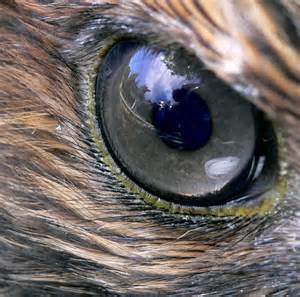
Close up of hawk eye. Public photo.
“The visual ability of birds of prey is legendary, and the keenness of their eyesight is due to a variety of factors: eyes size to body mass; eyes shape and make up– with more receptors, foveae, rods and cones giving the bird spectacular long distance vision, seeing more than 6-8 times better than humans.”
Let this young hawk inspire us. Let’s not take our eyes off our elected officials!
Help me watch them; help me push them; help me encourage them to fight the next four years for sending more water south from Lake Okeechobee, and over all water quality for our area canals, St Lucie River and Indian River Lagoon.
Hawk with airplanes from air-show in distance. (Photo Todd Thurlow.)
Congratulations especially to winners Senator Joe Negron; Congressman Patrick Murphy and Martin County Commissioner, Ed Fielding whom I supported and promoted in this election. I will be watching! 🙂
Sugar Hill Sector Plan and Airglades Airport’s location in reference to Lake Okeechobee, (Maps, iPhone, 2014.)
Since last week, you may have seen press on “Sugar Hill and Airglades Airport,” a land use change proposal located in Hendry County southwest of Lake Okeechobee. This is a highly controversial, approximately 67 square miles, of present “farmland” that could change to residential, (up to 18,000 homes), and commercial lands, built around an airport that is already in place with the potential to expand.
Just for comparison, the Airglades Airport runway is 5900 feet long while Witham Airport’s in Stuart is 5800 according to my husband Ed. (http://en.wikipedia.org/wiki/Airglades_Airport)
Anyway, this morning I do not have time to debate this issue in detail, but I will say of course that it is a true “game changer.” I wanted to SHOW where these lands are located in reference to lands that are still available for purchase by the state of Florida due to an option you may have heard of as well.
If purchased, these “option” lands would be key in Everglades restoration from Lake Okeechobee to the Everglades and restoring some pathetic remnant of its historic flow.
Presently, the state does not want to buy these lands because politicians claim there is no money to maintain them and if they were bought the lands will just end up “sitting there,” at great expense until a possible time they could be utilized in the future, like 2060.
This argument may sound “reasonable” but in order to save the Everglades and the St Lucie River/Indian River Lagoon, purchasing these lands is critical and should be done “now” because if these lands are not purchased “now,” as the Sugar Hill Sector Plan shows, their land use could be changed and then the lands will be too expensive for the state to ever purchase. Market value for agricultural lands is less than residential. Sometimes life demands you spend money now to save in the future.
So, just so we know where we are talking about, where are these Sugar Hill and Airglades lands located? See map below.
Airglades Airport and the Sugar Hill Sector plan are located south west of Clewiston by about five miles on the west side of Lake O along Hwy. 27.
They are located on Highway 27 west of Clewiston. Highway 27 runs through the Everglades Agricultural Area south of Lake Okeechobee connecting both coasts. The Airglades Airport and Sugar Hill Sector Proposal are located right before the highway shoots north. See red dots above and below. The 67 square miles of Sugar Hill Proposed Sector lands are “around” the airport. I do not know exactly where, but I would think mostly south.
At closer view, one can see the Airglades Airport amongst the sugar fields.
Now if we look at a partial map of the option lands we can see that the Airglades Airport and Sugar Hill Sector Proposal are located in lands that were designated for purchase to one day benefit Everglades restoration for posterity. (Dark green is of “most importance” and yellow is of “importance,” both are option lands…)
Map showing option lands close to Clewiston.
Overall EAA option lands:
Option Lands marked for purchase for Everglades restoration under former Gov. Charlie Crist. The deal fell apart due to politics and the financial crisis of 2008–a much smaller land purchase ensued.
OK…so how would this fit into the Plan 6, River of Grass restoration? Please keep in mind Plan 6 and all “plans” are fluid as they have not happened yet…The amount of water we are talking about it almost beyond comprehension and requires great areas of land beyond lines on a sheet of paper. So even though this Plan 6 chart concentrates flow between the Miami and New River Canals the lands west of this area where Sugar Hill would be located are part of the overall restoration plan for this area as we can tell from the option lands maps above.
Plan 6.Plan 6 flow, River of Grass.
In conclusion, and to repeat myself: all the lands marked as option lands are important for the overall Everglades/Northern Estuaries restoration project. The Sugar Hill Sector Plan, if successful, is setting a precedent for changes in agricultural land use in Florida. There may be no turning back on this at this point as the Scott Administration gutted the Department of Community Affairs that used to keep such land use changes in check. As usual the state of Florida has put development before restoration of natural lands and water’s protection.
When Florida’s future waters are just one big toxic algae bloom, and people do not want to live here, I wonder if some of our politicians will wish they had voted another way? Oh but they will be dead like me, so I guess it doesn’t matter….
It does matter. It matters almost more than anything in the world. Please make your voice known and let’s leave something to the children of the future other than cookie cutter homes.
Historic postcard ca. 1910 “Growing Sugar Cane.” Postcard courtesy of Sandra Henderson Thurlow.
The problem with “Sugar” is its location.
The war cry of the Rivers Coalition is “Move the Water South!”
Right now, this is not possible as the majority of the lands south of Lake Okeechobee are “blocked,” “taken,” “owned,” by the sugar industry. The 700,000 acres of the Everglades Agricultural Area (EAA) consist of mostly sugar cane on prime agricultural muck lands, some of “the most productive in the world.” “Cha, Ching!”
These lands that formerly allowed sheet flow from waters north of the lake to overflow and to nourish the Everglades have been drained since the early 1900s on a small level and then extensively after World War II and the Cuban Revolution. It was earlier in 1923 that Lake Okeechobee was first connected to the St Lucie River/Indian River Lagoon by the Army Corp of Engineers (ACOE) through the construction of the C-44 canal allowing massive drainage from Lake Okeechobee into the St Lucie River/IRL keeping the lands south of lake “dry.”
EAA. SFWMD map.
According to David McCally in his book The Everglades, An Environmental History published in 1999:
“What drainage accomplished in the Everglades was the conversion of a derelict system to a developmental one. A developmental system results when the natural world is converted into the basic infrastructure for intensive human development. Ironically, the modern American version of development is actually rooted in extensive destruction, but since that destruction does not lay waste human achievements, it is often ignored, and the close relationship between human development and the destruction of the natural world is overlooked.”
Proposed Everglades canal system/drainage, state of Florida, 1914.
Perhaps in the past this “destruction” was overlooked, but not today. A new value system has arisen. The people want the natural systems of the Northern Estuaries and the Everglades “to return.”
In my opinion, part of returning this paradise is finding a way for a third outlet from Lake Okeechobee. There are many parts to the puzzle and this is one of the major pieces.
It will be interesting with the governor’s race warming up to see what the message is on “moving water south.” The University of Florida study sponsored by Senator Negron’s Senate Hearing on the Indian River Lagoon and Lake Okeechobee Basin will not be finished until Spring of 2015. Therefore the candidates will have to speak on their own.
Rick Scott and Charlie Christ have basically kept silent on sugar/water issues so far. At some point, both, who have close ties to the sugar industry, will have to speak on the difficult position of sugar blocking the Everglades’ waters and destroying the northern estuaries.
Let’s sum it up now, before I start to sweat and need a sweet tea.
“Location, location, location….” Some things never change, but some things do, and that is up to us.
First major canals south of Lake Okeechobee, Miami and New River 1911. Drawing shows marsh lands, “swamp,” of the Everglades.
Cover of “Let’s Keep Florida Beautiful,” the environmental reelection plan for Gov. Rick Scott, 2014. Many Florida springs have stopped flowing and are choked with algae. The SPRINGS ETERNAL PROJECT explains the plight of Florida’s ailing springs: (http://springseternalproject.org) They, like our SLR/IRL, are dying.
Yesterday, I stumbled out of bed by 5:00 A.M to write my blog and make it to Palm City for the Collaborative Chamber Breakfast starting at 7:30 A.M. I had to get up as Governor Rick Scott’s kick off campaign tour to publicize his “Let’s Keep Florida Beautiful Plan,” was kicking off, in of all places, Martin County, Florida. I wanted to hear what he had to say.
Scripps reporter, Isadora Rangel, implies this morning in our Stuart News that Martin County was chosen as the kick off location because “it is the epicenter of grassroots efforts to clean the estuary.”
Reporter Isadora Rangel interviews Democrat, Congressman, Patrick Murphy who attended the breakfast. (Photo JTL)
There were about 200 people at Martin Downs County Club and both Democrats and Republicans and were present. The Lagoon goes beyond political boundaries. But politics abounds…
I greeted everyone from Democrat Maggie Hurchalla, to Republican Senator Joe Negron, and found my seat. I introduced myself to the people at my table. I looked around the room to see a veritable “who’s who.”
Hmmm? I thought.
In spite of the politics. This is pretty cool. Martin County has been chosen to kick off the governor’s reelection campaign. Why?
Because we are the most vocal little county in the state! Because 5000 people protested last summer at the height of the SLR/IRL toxic algae outbreak and releases from Lake Okeechobee. Our voices were heard. We practiced our right to assemble under our constitution. We are fighting still as last weekend’s 1500 plus at the Clean Water Rally showed. We have made a name for ourselves. Some of our politicians helped us, yes. But WE did it. We have called attention the dying St Lucie River/Indian River Lagoon, the canals and Lake Okeechobee and maybe now there will be help.
As I was daydreaming about how great Martin County’s River Movement is, the governor walked to the front of the room and took the microphone.
He was very well dressed and looked more comfortable than usual. He greeted the crowd and then told the story of his life:
Born in Illinois, single mom, did not know his father, step dad, poor, Eagle Scout, Navy, University of Missouri, Law-Southern Methodist, no money, worked since a kid, rose to success, went to church a lot as his mother said he would….no money…family….made money….the importance of jobs…
I sat there thinking that if the governor had a really good P.R. person they would have written a book on the “Eagle Scout” part….and not concentrated so much on the business….
So anyway, his assistants walked around the room and passed out a booklet with a photo of a spring on the front reading “Rick Scott, Let’s Keep Florida Beautiful.”
“Hmmmm? I thought. This is different. A pretty picture of a Florida spring and Rick Scott’s name on it.”
I opened up the booklet and right on the first page it read: DURING MY SECOND TERM I WILL: 1. Ensure that Everglades and Indian River Lagoon Restoration continue to have the vision and funding to provide a restored ecosystem to our children…”
“Remarkable” I thought. After the “Indian River Lagoon” having “no name” in Tallahassee for years, it is now listed in the first sentence of a governor’s reelection booklet. Will it happen? Time will tell. At least we are recognized.
One thing is for sure. Martin County is not just the epicenter for the Indian River Lagoon, it is the epicenter of water change for the whole state. No place has a reputation like we have. The governor choosing Marin County to start his campaign supports this point. Like him or not, that’s cool.
I have included photos I took of the booklet below. Some are blurry but it will give you an idea of what it says.
Politics are as toxic as the waters of the SLR/IRL. And we, little Marin County, have risen to the top of the fermenting algae heap. Be proud and keep fighting for the St Lucie River/Indian River Lagoon!
Booklet passed out at yesterday’s kick off re-election campaign for Rick Scott.
Gubitorial candidates wrote directly to the residents of the St Lucie River/Indian River Lagoon area on May 8th, 2014 in the Stuart News.
I didn’t pick up Sunday’s Stuart News until Monday, as I had been out of town. Sipping my coffee and holding the old fashioned paper, I love so much, my lips curled in a broad smile. The opinion page juxtaposed articles by two candidates running for Florida governor: Nan Rich and Rick Scott.
These letters were not just broad sweeping letters; they were thoughtful and personal, they mentioned the River Warriors and direct stories of inspiration from local residents. Don’t get me wrong, I know it is an election year, but nonetheless, it is simply amazing. In one year, since the discharges from Lake Okeechobee and our local canals turned our world upside down, and news of such “went viral,” the people have accomplished the most impressive of our forefathers’ American expectations. Expectations that years of social conformity and acceptance of over-development and pollution had overridden. The people of the Indian River Lagoon have stood up to their government.
The rebellion of the southern lagoon corresponded to the northern lagoon’s massive deaths of manatees, dolphins, pelicans and loss of almost 100% of its seagrasses. These die-offs and toxic algae blooms in the north, actually began happening in 2011 but did not come out publicly until the uprising in the southern lagoon blended the two tragedies.
I know for many of my friends the politics of the River Movement is hypocritical, frustrating and painful. I feel the same way. In fact lately I have been a bit depressed over the whole thing. But I am getting out of it. Boy is it a pleasure to see that paper, to be in the drivers seat, to have “them” writing letters, visiting, and actually thinking that there is no longer a “golden ticket” to pollute. I have been in Martin County many years, and on “this level,” “this” has never happened before.
Finally, even Senator Rubio is getting heat in the press; long standing Senator Nelson is happy he’s been around, but also nervous he is part of the lagoon “establishment;” Charlie Crist is taking out his old notes about US Sugar; Senator Negron is promising more for the lagoon in 2015; Congressman Murphy is regrouping and studying the Farm Bill after the ACOE refused CEPP on his watch; and the future speakers of the Florida house and senate are making their cases for the future of “water.”
Many times the lagoon has been defiled by our government, in fact 2013 was not the worst its ever been. But I am telling you, this time it is different because of “us.” This time we have exposed them. This time we are asking truly for government to do what it is supposed to: “protect the health; safety and welfare” of its people. This time we are united in a brotherhood and sisterhood of diverse backgrounds and interests. This time we have reached a tipping point, as has the lagoon.
And most important for change, this time, “they” are watching and listening to us.
Please take advantage of this opportunity. Don’t turn your back because the politics are so repulsive to watch. Look to the sky—look to the river ——write a letter or make a call and say : ‘thank you; we are happy you are taking an interest in the lagoon; I will be weighing who to vote for based on who really has the desire, passion and an honest heart.”
These politicians may never be able to reach perfection, their world is pretty insane, but be grateful they are paying attention, and know you are a force for change in a way never before. Drive your points home!