Tag Archives: Sugar Industry

Sugarcane, Indians, and Roundup, Professor Geoffrey Norris, SLR/IRL

Today I share the second paper of guest, Geoffrey Norris Ph.D. I recently shared Blue-green algal blooms in the lakes, rivers, and marine waters of south Florida surrounding Lake Okeechobee.

I must admit, I hesitated publishing this second paper, “Sugarcane and Indians,”  as I  am sure some may interpret it as “politically incorrect.” I apologize to anyone who may, but I decided to print Dr Norris’ paper because the main message is important.

The message is:

“Is Sugar’s use of ripening stalks with “Roundup” feeding toxic algae blooms and why are lands/waters south of Lake Okeechobee “protected” while ours of the northern estuaries are not? “

You will learn something about this in Dr Norris’ paper below, and I thank him for sharing his work.

In closing, I believe we have something important to learn from history and the Native People of North America; I admire them. They are great warriors and respect Nature, the gift of our Creator. And in the case of the Miccosukee, they “never surrendered” and if I have anything to do with it, neither will we.

Jacqui

(http://www.miccosukee.com/tribe/)

10436158_10204260686776858_4557505988020125387_n.jpg
JTL 2015 Miccosukee Reservation, Tamiami Trail

IMG_9307.jpg

file-page1-2.jpg

This blog is the work and opinion of Professor Geoffrey Norris

IMG_1003

 By

Geoffrey Norris Ph.D. FRSC

http://www.es.utoronto.ca/people/faculty/norris-geof/

..”In the 1960s, I lived and worked as a petroleum exploration geologist in Tulsa, Oklahoma. Subsequently, I spent almost 40 years at the University of Toronto in teaching and research in geology…A geologist by training, I have a specialized knowledge of fossil algae, their ecology, morphology, and distribution. I have published hundreds of scientific papers on fossil algae and related topics.”  ~Geoffrey Norris Ph.D.

rosalex@interlog.com

unknown.jpgSugarcane and Indians

Executive summary

  • The area around Lake Okeechobee accounts for almost half the total production of sugarcane in the United States.
  • Sugarcane in south Florida is very needy of phosphorus and potassium fertilizers, but nitrogen fixed in the muck soils largely eliminates the need for extra nitrogen fertilizers.
  • Sugarcane also demands the use of the phosphorus-rich herbicide “Roundup” (glyphosate) several times each year. Firstly, in the fallow season (approximately May-September) to control weeds and allow the sugarcane underground rhizomes to regenerate.  Secondly, as the new shoots come through in the Fall to continue weed control.  Thirdly, during maturation and harvesting (October through March) glyphosate is applied to “chemically ripen” the sugarcane and improve sugar yields.
  • Land south of Lake Okeechobee could be used for storage and bio-cleansing of excess lake water. However, the 1997 water quality agreement between the Environmental Protection Agency and the Miccosukee Indians (aka Mikasuki, Miccosuki) states that phosphorus shall not be present in quantities greater than 10 parts per billion, and that no substance shall be present to stimulate algal growth and produce objectionable algal densities in the 300,000 acres of tribal lands in the Everglades south of Alligator Alley.
  • This legal agreement would suggest that Lake Okeechobee waters destined for southern storage must be cleaned to rigorous standards before discharge into southward flowing streams feeding the Everglades, at least near the Miccosukee tribal lands.
  • A case could be made for the sugar industry and related agriculture to “clean up its act” to mitigate the effects of heavy fertilizer and herbicide usage on the environment in general and on lake and stream waters in particular.

Sugarcane and Indians

First about nutrients and farm land and how much is planted in sugarcane.

Here are three maps that graphically answer the question about the extent of sugarcane plantations:unknown.jpg

unknown.gif

1__#$!@%!#__unknown.gifunknown.png

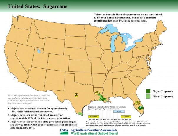
A couple of years ago I had the opportunity the fly over the area south of Lake Okeechobee in a light plane at about 1000ft altitude.  The extent of the sugarcane is truly mind-boggling. Its plantations surround the entire southern perimeter of the Lake and reach to the horizon.  Smaller plantations occur elsewhere around the Lake.  It is a very big operation.

Now to the nutrients themselves.  I had a great deal of difficulty finding precise information on how much fertilizer is applied per unit area.  There were general articles that confirmed that sugarcane is very needy of nitrogen, phosphorus, and potassium fertilizers together with other elements. It is after all a giant grass, so just think how much stuff you have to put on your own lawn to make it grow green!  Apparently, in the south Florida area the need to apply nitrogen fertilizer to sugar cane is not so critical because the mucky soils generate their own nitrates through soil microbial activity.  However, phosphates must be applied as  fertilizer for sugarcane at various times of the year together with potassium etc.  But actual numbers were hard to come by, other than that sugarcane is voracious for fertilizers.  This is when I stumbled upon some marvellous work that the U.S. Geological Survey has been doing on the extent and the total quantitates of pesticides being applied to farmland across USA.  I used their maps of glyphosate (Roundup) as what I thought might be a reasonable proxy for phosphate fertilizer.  In other words, if you use Roundup as a weedkiller on crops, then very likely you will be using fertilizer as well.  It turns out I was right and I was wrong!  First take a look at this summary map for two separate years, 1992 being the earliest year available in this USGS study:

Details are difficult to see in these summary maps but the originals are much clearer.  The area around Lake Okeechobee was already in 1992 applying large amounts of glyphosate, and this intensified in succeeding years.  What I didn’t understand was why the sugarcane fields should be so needy of weedkiller – fertilizers OK, but why so much weedkiller?  It would seem that 25% of the cost of sugar production is due to heavy nutrient need (up to 75 lbs phosphate per acre, with 400,000 acres in sugarcane in south Florida).  But weedkiller.  Then I dug deeper following your email comments and found out why.  Indeed glyphosate is used at least three ways on sugarcane as follows:

Firstly, during the fallow season (approx. May-September 2016) following harvesting, glyphosate is applied to control weeds which would otherwise grow up and choke out the underground cane sugar rhizomes left in the ground to regenerate as the next crop.

Secondly, glyphosate application continues in different amounts as the new shoots come through in the Fall.  This is tricky because glyphosate kills just about anything that is green, but careful control can kill the young weeds while not harming – at least not very much – the young sugarcane shoots.  Other herbicides are also involved but glyphosate is the big one.

Thirdly, the sugarcane matures and is harvested in the winter months at various times from October through March.  During this time the stem of the sugarcane ripens and becomes rich in sugar (sucrose) prior to going to the mill.  Astonishingly (to me anyway) it has been found that about a month or two prior to harvesting, another application of glyphosate will help ripen and enrich the crop with significantly more sugar.  This process is called “chemical ripening”.  Other chemicals can be involved but glyphosate is a popular choice (it got cheaper once Monsanto’s patent expired in the year 2000).

So yes, I think cane sugar farming is being pursued intensively, but I’m not sure how it can be stopped.  Its effects on Lake O could be mitigated as discussed in my previous document but stopping an entire industry would be almost impossible to my mind.  Cleaning up the sugar industry might be a more realistic aim.
Change of land usage and water flow.

It would be nice to think that Lake Okeechobee water could be redirected southwards along its original historic course on its way to the Everglades.  Here’s a graphic of how things used to be:
1__#$!@%!#__unknown.jpg
For thousands of years, water drained from Lake O through a wide series of shallow tributaries and interconnected lakes to the Everglades.  It’s unlikely that this could be recreated but certainly use of land south of the Lake for water transport and storage and bio-cleansing of some sort or another would be an improvement.  However, it would seem that this is unlikely given the actions of the U.S. Environmental Protection Agency and its agreement in 1997 re the  Clean Water Act with the Miccosukee Indians, a tribe which occupies part of the Everglades.

Click to access miccosukee.pdf

This agreement set out comprehensively water quality standards for the Tribes drinking water, wildlife habitat water, and recreational water (boating, swimming etc).  In particular, Section 3 reads:
MICCOSUKEE ENVIRONMENTAL PROTECTION CODE
SECTION 3. Tribal Water Quality Standards

The following minimum water quality criteria shall apply to all surface waters of the Miccosukee Tribe of Indians of Florida unless those water bodies are designated with higher or stricter water quality standards. Stricter standards for a given water body shall supersede these general Water Quality Standards. These standards shall provide a legal basis for including whole effluent toxicity requirements in all federally issued permits.

(there follows a list of 16 physical, biological, and toxicological conditions of which these two are particularly germane):

E. NUISANCE CONDITIONS: Plant nutrients or other substances stimulating algal growth, from other than natural causes, shall not be present in concentrations that produce objectionable algal densities or nuisance aquatic vegetation, or that result in a dominance of nuisance species instream, or that cause nuisance conditions in any other fashion. Phosphorus and nitrogen concentrations shall not be permitted to reach levels which result in man-induced eutrophication problems. Total phosphorus shall not exceed 10 parts per billion in Class III-A waters. In Class III-B waters, total phosphorous discharges shall not be made which result in undesirable aquatic life effects or which result in chronic or acute toxicity to aquatic life.

N. NUTRIENTS: In no case shall nutrient concentrations of Tribal Class I or Class III-A surface waters be altered so as to cause an imbalance in natural populations of aquatic flora or fauna. Total phosphorus concentrations shall not exceed 10 parts per billion in Class III-A waters. In Class III-B waters, nutrients shall not be discharged which result in undesirable aquatic life effects or which result in chronic or acute toxicity to aquatic life.

So what this and other sections of agreement mean is that nutrient-rich water from Lake Okeechobee must be cleaned to rigorous standards before discharge into southward flowing streams feeding the Everglades.  So bio-cleansing within the Everglades – or at least near the Miccosukee tribal lands (about 300,000 acres in the vicinity of the Tamiami Trail and Alligator Alley) is not a possibility within this legal framework.

2__#$!@%!#__unknown.gif

However what’s good for the goose is surely good for the gander.  I looked into the history  of the Miccosukee Indians, and it would seem they are only fairly recent arrivals in Florida, arriving about the same time as Stuart was being settled.  The Miccosukee appear to have originated in what is now Georgia and then migrated south to north Florida where they became entwined with the Seminoles.  After the Seminole wars of the 19th century they migrated to central Florida in the late 1800’s and then decided to disentwine themselves from the Seminoles as a culturally distinct society.  They appear to have seen an opportunity during the construction of the Tamiami Trail in the first quarter of the 20th century and migrated further south and became embedded in the adjacent Everglades. First  Florida (1957) then federally (1962) they became recognized as a tribe distinct from the Seminoles.

Meanwhile in th early 20th century, as the migrant Miccosuki Indians were settling down in their new home in the Everglades as “Trail Indians”, Stuart was incorporated as a town (1914) then a city (1925) after being settled by migrant northerners about half a century earlier.  Total population of Stuart is now about 16,000.

640 migrant Indians – how many are fishing  and frogging?  16,000 migrant non-Indian northerners – how many lives and livings are being disrupted by ruined beaches and waterfronts?
the Indians pushed for a great deal from EPA and got it.  So now a total of about 640 Miccosukee (Mikasuki) Indians (some now  living in Miami-Dade and not the Everglades) can pursue their supposedly traditional way of life (fishing, frogging, subsistence agriculture) plus gaming resorts and casinos and tobacco shops – while many of the 151,000 citizens of Martin County are prevented from pursuing their traditional way of life.  Surely our waters (habitat, recreational, drinking) should be subject to the same rigorous standards as laid down by the EPA/Clean Water Act for the people living in the Everglades.

We are all equal – as George Orwell said – but some are more equal than others.  Well, so it seems.  What do you think?
_________________________________________________________

River of Interest, ACOE, The Ultimate Hammer, chapter about the lawsuit http://141.232.10.32/docs/river_interest/031512_river_interests_2012_chap_12.pdf

Alligators and Litigators: Keith Rizzardi http://www.floridabar.org/DIVCOM/JN/JNJournal01.nsf/76d28aa8f2ee03e185256aa9005d8d9a/d0fe7ce69afa102885256adb005d635e?OpenDocument

Previous blog post, Norris: Blue-green algal blooms in the lakes, rivers, and marine waters of south Florida surrounding Lake Okeechobee: http://jacquithurlowlippisch.com/tag/dr-norris/

The Road of No Return, Connors’ Highway, Lake Okeechobee, SLR/IRL

Fingy Conners, History’s Forgotten Villain

Video about Fingy Connors:https://www.buffalorising.com/2013/09/fingy-conners-historys-forgotten-villain/

Canal Point, the lake town just south of today’s Martin County line, was once an epicenter of life changing activity, a road trip there is no turning back from…

As we learned previously, in 1917, the construction of the West Palm Beach Canal created Canal Point, the town of lumber-man and developer, Mr. Gilbert A Watkins. During this era, planting sugarcane in the rich muck soils surrounding Lake Okeechobee was becoming even more of a rage and the federal and state government helped it take shape.

In 1913, Florida’s Internal Improvement Fund appointed an engineering commission to study the feasibility of draining the Everglades. At this same time, roads were assessed. In 1919 those belonging to Southern Land and Timber Company, Hamilton Disston’s heirs’ lands around Lake Okeechobee–some that became Watkins’—were determined to be “inadequate.” The only east/west road was Jupiter -Indiantown, and that was not enough.

Nationally, it was all the rage to be part of South Florida’s new-found” investment. “Buffalo’s New Yorker, Fingy Connors, was perfect for the job. He’d lost his thumb when he was young, but this didn’t keep him from grasping or getting what he wanted. After a visit to the area celebrating the building of the West Palm Beach Canal, he bought lands in the area of Canal Point and built his road.

Connors’ Highway Toll-Road became an “engineering and development marvel” and all knew it was Fingy’s skill as a big time political boss that got it done. Like the video and biography in this post implies, some saw him as a villain, and others as a hero…

What is for sure, is that although a large section of the road was built from Canal Point north to Okeechobee, it later was extended under the lake and across the state becoming Highway-80, paving the way for the future of the sugar industry  and what would  evolve into the riches of the Everglades Agricultural Area.

Fingy-Conners-Buffalo-NY 2.jpg

____________________________

William Fingy Conners

Tycoon, Saloon Boss, Businessman, Politician, Philanthropist:

William J. Conners, aka Fingy (1857-1929) was born in the slums of the Old First Ward. Fingy obtained his nick-name because he lost his thumb when he was young. When he was 19, his parents passed and he acquired a small saloon/rooming house on Louisiana St. He then bought a 2nd saloon on Ohio St. With Conners’s flashy, tough personality, he managed to form contracts to supply labor all across the Great Lakes utilizing 1,000s. His men would eat, sleep, drink, and spend their earnings at his saloons. He had sovereignty over the work force for over a decade. Next in life, he became a leading real-estate developer, operated his own paving company and brewing company, poultry farm, and started the early stages of the Courier Express. Conners definitely tested the waters by reducing wages of grain scoopers which caused a strike. This strike caught nation-wide attention, as 8,000,000 bushels of wheat were backed up. After dipping into politics, he came to control 85% of the packaged freight business on the Great Lakes (Great Lakes Transit Corporation). Conners donated a small fortune to Buffalo’s poor. Later in life, Fingy resided in Florida for half of the year. Floridians considered Fingy to be of hero stature.

HISTORIC PHOTOS CIA FLORIDA MEMORY, CONNORS’ HIGHWAY 1920s.

pr07727.jpg
Connors’ Hwy. toll area with non-diked Lake Okeechobee in background ca. 1925. (Florida Memory Project)
KOR0872.jpg
A car drives along Connors’ Hwy. with Everglades fauna to right. (FMP) 
n045289.jpg
Connors’ Hwy and Everglades fauna. 

n031638.jpgn031637.jpg

rc13433.jpg
Cistern with Lake O in background.
pr04251.jpg
Connors’ Hwy along area of canal or rim canal-here I am uncertain but this photo too is included in the Florida Memory Projects documentation of the Connors’ Hwy. 

HISTOROR MARKER TEXT AND PHOTO

2016_11_05_14_09_00-1.jpg

IMG_6481.JPG

*Thank you to my mother for the photos retrieved from Florida Memory and the write up of the historical marker and the video history.

Palm Beach Historical Society:http://www.pbchistoryonline.org/page/land-boom-and-bust-conners-highway

https://dedicatedtobuffalo.wordpress.com/history/defining-men/fingy-conners/

#5 PAC “Committee to Protect Florida,” Inside the Alligator Pit, SLR/IRL

Crocodile_marin_Thoiry_19801

UF go gators micc 10436158_10204260686776858_4557505988020125387_n - Version 2.jpg

JTL vs the Political Machine,  A Retrospective, Part #5

When I saw my mother yesterday, she said, “Jacqui, I think you need to stop writing about those PACs…I get it now…” One of my Grassroots Team members implied that I may ruin my reputation for running a clean campaign, and compromise my chances to run again,  with all the harsh comments coming in on my recent posts….My husband looked at me wide-eyed over a glass of wine: “I thought you tried to keep your campaign out of the blog…?” Joe Catrambone, CEO of the Stuart Chamber, who I like very much, sent out a group email saying: “Jacqui isn’t accepting defeat very well! Speaks volumes doesn’t it!!!”

For those of you who are uncomfortable, or think I am a sore loser, please don’t fret.  Today will be my final day investigating those who spent time and money to affect my loss for Martin County Commission District 1.

I do apologize to the Stuart Chamber as they really don’t belong in the category of reptiles as they chose not to send out a negative post card against me, just for Doug Smith; I was simply trying to make the point that the influence of Tallahassee affects home.

Early on, in my own head, I knew that whether  I lost or won, I would be reporting on the outcome dynamics of the campaign in my blog. Writing on this issue is all part of my river journey. I know what I am doing, and it will be shared. These insights in time will help us get closer to saving our dying river…

Mom, “don’t worry,” I will stop taunting the alligators very soon! 🙂 But first we must try to see the truth behind the scenes.

Here we go:

#5

Our last PAC to add to the previous three days of postings: Write in Candidate Chase Lurgio;  Martin County Firefighters Union’s “Citizens for Public Safety;” C-Pac; and “Committee to Elect Real Conservatives;” (all ridiculous names) and today’s”Committee to Protect Florida.”

So when we look at the third negative post card that came out against the JTL campaign, we see on the bottom it reads: “Paid electioneering Communication for by Committee to Protect Florida, PO Box  102005 Tallahassee, FL 32302.” It is yet another ad full of lies, but I do appreciate that they used two of my favorite pictures of myself, my younger looking real estate head shot from 2007 and the hysterical “piranha photo” Ed took of me in Peru along the Amazon River.

IMG_5280.jpgIMG_5281.jpg

So let’s quickly do what we have learned and look up this PAC on the Florida Division of Elections website by COMMITTEE: http://dos.elections.myflorida.com/committees/

IMG_5322 2.JPG

This PAC’s chairperson is Mr Roger “Rockie” Pennington. Mr Pennington is a very well-known in Tallahassee politics.  I first heard about Mr Pennington, when I was told in the last campaign cycle that he ran  Doug Smith’s campaigns. At the time I wondered why Doug would use someone from Tallahassee….

Rockie Pennington owns Southern Campaign Resources, and according to his website “has been a fixture in Republican politics for nearly four decades.” You can read more here: http://www.southerncampaigns.com

Let’s look up who contributed to his PAC:  ironically the Florida Chamber of Commerce at over $100,000 dollars, Florida Jobs Pac, $50,000. These are the same PACs that gave money to C-PAC and Committee to Elect Real Conservatives from yesterday with sprinkles of the sugar industry.

But what is even weirder is when you look up “Nature Coast Conservatives” that gave the lion’s share of the donations, $100,000s of dollars. This PAC is run by Roger Pennington’s partner in Southern Campaign Resources, Mr Mark Zubaly who is listed along with Rocky Pennington on the bio page of Southern Campaign Resources.

IMG_5324 2.JPG

As the bio states “(Mark) is a partner in two Tallahassee-based companies that count at least one-fourth of the Florida Legislature among their clients: Southern Campaign Resources, a political consulting and lobbying firm, and Summit Communications, a media production firm. He also serves as the campaign consultant to a number of Florida’s city, county and judicial elected officials.”

http://dos.elections.myflorida.com/campaign-finance/contributions/

And yes…Mark Zubaly was also Rockie Pennington’s PACs treasurer…

IMG_5327.jpg

IMG_5316.jpg

IMG_5319.JPG

Of course as you dig deeper the money keeps going and going and going….

So The Doug Smith Campaign had its own campaign manager with his own PAC with his own partner funding the PAC from his own PAC that uses many of the same questionable donors that were linked to, C-PAC, and the # 2 post card of Josh Cooper who ran opposition research for the Governor. On top of this there was the Firefighters Union PAC, Citizens for Public Safety, sending out positive post cards for Doug Smith, sending out negative post cards against JTL all the while building signs, placing signs, making negative phone calls against JTL, pulling up opposition JTL signs, and waving….

I’d say we did pretty well considering our opponents! What an alligator pit!

I feel like we’re in a Carl Hiaasen book! We don’t even need to go to Miami!

In conclusion, The Jacqui Thurlow-Lippisch Grassroots Campaign lost to this Political Machine by 2.9% or 677 votes…raised considerably more money and had considerably more diverse support. Supported a clean river and land purchase south of lake…in any case, did not support the status quo…

Wow! What a race!

It was exciting!

And now that we know who we’re in the pit with, maybe next time we’ll get them on their backs and Protect Florida For Real.


5160292020_2c533d6d1d_o 2.jpg


Trying to Understand the Structure of the SFWMD within Government, St Lucie River/Indian River Lagoon

Florida Statutes books on shelf. Public photo.

If there is one thing I have learned in my seven-year stint in local government, it is that for the public, the structure of government and how it works is unclear. In my opinion, this happens due to many reasons, but first and foremost is because government as a whole is terrible at being open and explaining itself, perhaps preferring to function behind a shroud of confusion. Also, governments’ sense of responsibility to communicate with the public is often nonexistent or skewed at best… plus communicating is expensive…This situation is compounded by the fact that every year there are new laws, and every few years new elected officials coming in….so the public is constantly having to “catch up.”

To make a point, let me give a simple example from the Town of Sewall’s Point, where I live and am a town commissioner. Prior to 2006 the town did not have a full-time town manager. In 2006 the town charter was amended by the commission creating a manager/commission form of government as opposed to commissioners being in charge of different departments. I was elected in 2008. For years, many citizens did not know this change had occurred, and their expectations were functioning off the old system and their expectations were not met. They came into the commission meetings very upset. The town did not “advertise” the charter changes. I was too new to really understand what was going on….it took me a year or so to figure it out, and the public—

People are too busy trying to live their lives, raise their children, and “put bread on the table,” to follow every move of government be it local, state or federal. Add to this that government itself is a terrible communicator, and what happens? The mechanisms are not in place for government to work….This is how I see it anyway. The answer? Better communication and learning to understand how things work.

A few months ago when the South Florida Water Management District was ignoring a desperate and pleading public that had come before them begging for the purchase of the US Sugar Option Lands through Amendment 1 monies, to help save the St Lucie River/Indian River Lagoon and Calooshatchee, I drove to West Palm Beach and met with high level officials. They were very nice but it was a frustrating meeting. Basically I asked them, “What are you doing?” “Why are you acting like this?”

The answer?

“Commissioner, you know the power isn’t in our hands anymore anyway…”
“What do you mean?” I inquired.

A conversation around the table ensured:

SFWMD: “Well after the debacle that occurred 2008-2010 with then Governor Charlie Christ, the recession, and the attempted buyout of all of US Sugar’s lands, basically a water district was trying to purchase a corporation…..the Florida Legislature got fed up.  So later,  in section 373.556 of Florida Statutes, the Florida Legislature made sure the District would never be in a position to do that again….Significant legislative changes have occurred related to water management budgeting with substantial ramification for Water Management District land transactions. In 2013, Senate Bill 1986 provided that certain District land transaction should be subject to the scrutiny of the Legislative Budget Commission. As this bill renewed the authority of the Governor to approve or disapprove the SFWMD budget, as with all water management budgets of the state, we can no longer do things we have done in the past like oversee giant land purchases using the monies from our ad-valorem taxes…There is a lot more to it but that’s the main difference now. You are talking to the wrong people….”

I stood there just staring…..”I didn’t know this gentlemen, so how do you expect the public to know this ? Are you telling me, the SFWMD has no power to purchase those Sugar Lands?”

“I am telling you the legislature is in charge of the budget and we don’t have enough money to buy the lands, and couldn’t without their approval….”

“So why don’t you explain that to the public?” I asked.

Stares….

Long awkward silence….

The reply was more or less: “It’s best not to get involved in such a discussion…..”

I lectured them on the importance of communication and education and said they certainly still have influence even if they say they “do not” …..but this did go over particularly well… the meeting ended. I shook their hands. I felt like an idiot. I drove home.

Since that time I have been trying to learn more…..So I read about the history of the Water Management Districts in Florida.

Florida's five water managements districts map DEP.
Florida’s five water managements districts map DEP.

To me it seems that originally when the water management districts were created in the 1970s they were allowed to levy taxes from the public in order to be an independent entity of water knowledgeable citizens  advising the governor as to how best manage water resources.  Also, the Dept of Environmental Protection was just evolving at this time so when the water districts were formed they did not work “under” or “beside” the DEP like today.

Over time, the laws have changed and our water management districts  have become an arm of the governor and his or her people in the state legislature. The SFWMD is and has been losing its power. Especially since 2013. This  loss of influence has politicized the structure of Florida’s water management districts to a level that “the people” no longer have a voice locally with their districts, and they don’t know they are now expected to go to their state legislature;  and even if they did, their local delegation is one in hundreds in that structure  that would need to be convinced to change water policy (for land purchase south of Lake Okeechobee for the health of the estuaries, for instance.)

I have learned too through this journey that really today about ten people run our state: Right now it is our governor, Rick Scott: cabinet members, Adam Putnam, Dept of Agriculture; Pam Bondi, Attorney General; Jeff Atwater, Chief Financial Officer; “leadership,” Speaker of the House: Steve Crisafulli; President of the Senate, Andy Gardiner; and the committee heads of the senate and the house which are only a few “tapped” people. (People who have agreed to conform or are smart enough to walk the razors’ edge.)”Leadership” keeps all elected officials  in line by allowing them, or not allowing them, to be on, or to chair, certain committees, or by allowing, or not allowing their bills “to be heard”… also by discouraging new candidates from running for office if this is against “leaderships’ master-plan.” This behavior is worse in the republican party than the democratic party, but they are all encouraging conformity rather than leadership.

So how can we best communicate with our government?

Hmmmm?

Let’s keep educating ourselves,  and can anyone say “revolution?”

Seal of Florida
Seal of Florida


2013 DEP letter explaining changes to SFWMD structure: (http://www.dep.state.fl.us/secretary/watman/files/017_Land_Acquisition_Revised_Guidance_032713.pdf)

2011 DEP letter leading up to changes in 2013 letter above:(http://www.dep.state.fl.us/secretary/watman/files/004_land_acquistion_042511.pdf)

DEP Florida’s Water Management Districts:(http://www.dep.state.fl.us/secretary/watman/)

SFWMD, Florida’s oldest water management district: (http://en.wikipedia.org/wiki/South_Florida_Water_Management_District)

Florida Statures Section 373 (http://www.leg.state.fl.us/STATUTES/index.cfm?App_mode=Display_Statute&URL=0300-0399/0373/0373ContentsIndex.html&StatuteYear=2014&Title=%2D%3E2014%2D%3EChapter%20373)

The Mechanization of the Sugar Industry as a Metaphor for Change, St Lucie River/Indian River Lagoon

Historic postcard, ca.1900 sugarcane in Florida, from the Thurlow Collection.
Historic postcard, ca.1900 “Cutting Sugarcane in Florida,” from the Thurlow Collection.

This week, due to the inspiration of small book my mother handed me, I have been exploring the history, and political change encompassing the sugar industry. Monday, I wrote about Cuba; Tuesday, I wrote about the Calusa Indians, pioneers, and workers; and yesterday, I wrote about  the pond apple forest that used to border the southern rim of Lake Okeechobee.

Today, based on chapter 29 of Lawrence E. Will’s 1968 book, “Swamp to Sugar Bowl, Pioneer Days in Belle Glade,” I will briefly write about the evolution of labor practices in Florida’s sugar industry and how public pressure led to the mechanization of the industry. For me, the mechanization of the sugar Industry is a metaphor for change for our St Lucie River/Indian River Lagoon.

The point of this journey is to learn our history and to remind ourselves that even the “worst of circumstances” can be improved. I believe, that one day, we too, will see improvement of the government sponsored destruction of the St Lucie River/Indian River Lagoon from Lake Okeechobee. Our relation to the sugar industry? For those who may not know.. .Their location blocks the flow of Lake Okeechobee’s waters flowing south to the Everglades. 

The delay of CEPP, the Central Everglades Planning Project may end up symbolically being the beginning of Florida's  4th Seminole War.
The Everglades Agricultural Area is just south of Lake Okeechobee, it is composed mostly sugar farming and block the flow of waters flowing south from Lake O so they are directed to the northern estuaries. (EF)

Before I start, I must say that “everyone has a history,” and the history of the world is mostly “not a pretty one.” This goes for me as well. Parts of my family have been here before the American Revolution, and a few of  my ancestors owned slaves. I have read the wills these relatives handing down their slaves from one generation to the next like these souls were pieces of furniture. It is retched. It is uncomfortable. It is immoral. But to forget, is not the answer. It is important to know our own history and the history of businesses in our state no matter how difficult. As is said, we must “Never Forget…” Slavery and the extermination of Florida’s native peoples “is the ground we sit on,” and our job today is to continue to make this world, and our living waters a “better place.”

Back of postcard.
Back of postcard.

So, let’s begin.

The history of sugarcane has “roots” all over the world, but in our area it is connected to the Caribbean. I recommend a book entitled: “History of the Caribbean,” by Frank Moya Pons.

The basis of this book is the extermination of the Arawak Indians due to colonization and the bloody wars on both sides of the Atlantic over control of the region’s lucrative sugar market . The Arawaks were native to the Caribbean. When they were unwilling slaves for the Europeans, and died as a race due to european-brought diseases, African slaves were brought in to replace them.

After centuries involving  world political struggles for “sugar dominance,” and with the rise of the United States and the horrible world wars, sugar came to be seen as “national security issue,” not just a food source as it can be used for the making of explosives/weapons.  As we know, over the centuries, through political strategy, the United States rose as a power in sugar production, as Cuban dominance declined.

The apex of this shift in our area was around 1960. For reference, my husband, Ed, came to this county when he was four, with his family from Argentina, in 1960, the Perons had been in power; and I was born in California, at Travis Air Force Base in 1964. It was the Vietnam Era.

The Everglades Agricultural Area south of Lake Okeechobee where the sugar industry resides expanded the most it ever has around this time. To quote Mr Lawrence E. Wills:

“when Fidel Castro took over Cuba, (1958) the Everglades reaped the benefit. For a short time our government permitted the unrestricted planting of sugar cane …and before that time, under the U.S government’s regulations, the state of Florida was permitted to produce only nine-tenths of one percent of the nation’s needs.”

The US government helped the sugar industry grow and for “a reason:” Power. Influence. National Security. Food Source. Weapons. This is heavy currency in world politics and it is achieved at any expense….here in south Florida, it was achieved at the expense of the uneducated and poor worker.

Chapter 29 of Mr Will’s book is entitled, “Harvest of Shame.”

(http://www.bing.com/videos/search?q=Documentary+Harvest+of+Shame&FORM=RESTAB#view=detail&mid=D9218CAC685FC8880984D9218CAC685FC8880984)

Mr Wills writes about a television documentary that was released on Thanksgiving Day in 1960. Mr Wills says the piece is “sensationalized.” It was produced  by the Columbia Broadcasting System, presented by Edgar R. Murrow and sponsored by Philip Morris Cigarette Company. Certainly the piece was “sensationalized,” but undoubtedly there was also truth regarding the difficult conditions for migrant workers.

What is important here, is that the explosive public reaction to the documentary pressured the sugar industry to move towards mechanization, which they achieved just over thirty years later around 1992.

As the industry moved towards this goal, other problems ensued, such as H-2 program changes.  With claims that the local labor force “could not,” or “would not” do the back-breaking work of cutting the sugar cane with machete, the H-2 program allowed the sugar industry to hire foreign workers, mostly from the Caribbean, especially Jamaica, who as we already know had a history with this difficult work.

The rub for labor activists was that these workers could be deported if they did not “produce.” They could be shipped out and replaced. Some called this a form of modern slavery. An award-winning documentary, on this subject, H-2 Worker, was produced by Stephanie Black in 1990. She points out that although the sugar industry had basically achieved mechanization by this time, others had not. (http://www.docurama.com/docurama/h-2-worker/)

The sugar industry moved to mechanization because of public outcry. Of course it is more complicated than that and is driven by economics, nonetheless, it was a huge factor. With more outcry regarding our St Lucie River/Indian River Lagoon, the same thing could happen. Change. More water flowing south. A flow way. A reservoir. Lands to clean, store and convey water south….fewer, or no more polluted/toxic releases into the St Lucie River/IRL…

To deviate just a bit before I close, we may ask ourselves, how could this happen? Slavery? Mistreatment of workers? Destruction of the environment?

Well, the answer is the same today as it was in 1500; it happens because government allows, supports, and encourages it. The U.S. Department of Labor, the United States Department of Agriculture and others. Some right under our nose.

USDA: (http://naldc.nal.usda.gov/download/20644/PDF)

Remember, today’s state and federal agencies are made up of people; people are hired by government entities;  government entities are directed by politicians, and politicians are voted for by the people. It all starts with us.

Make sure your voice is heard, and vote accordingly.

History is in the making, and somewhere out there, there  is a better water future for the St Lucie River/Indian River Lagoon!

Inside page of Stuart News, US President Obama meets with Raul Castro, Fidel Castro's brother, 4/2015.)
Inside page of Stuart News, US President Obama meets with Raul Castro, Fidel Castro’s brother, 4/2015.)

_______________________________________________________________

Another source for this post and excellent reading is “Raising Cane in the ‘Glades, The Global Sugar Trade and the Transformation of Florida,” by Gail M. Hollander. (http://www.press.uchicago.edu/ucp/books/book/chicago/R/bo5704198.html)

Public Information on H-2 Lawsuit: (http://www.leagle.com/decision/19951403660So2d743_11274.xml/OKEELANTA%20CORP.%20v.%20BYGRAVE)

Agriculture’s Eradication of the Mythical Pond Apple Forest, Lake Okeechobee, SLR/IRL

Photo of pond apples in Big Cypress, a shared flicker photo by Mac
Photo of pond apples in Big Cypress, a shared Flicker photo by Mac Stone, 2014.
Pond apple also known as custard apple--this is the custard apple forest as depicted by artist Julia Kelly in the River Kidz second edition workbook, 2015.
Pond apple is also known as custard apple–this is the custard apple forest as depicted by artist Julia Kelly in the River Kidz second edition workbook, 2015.

In Florida, the pond apple is also known by many locals as the “custard apple,”(http://www.regionalconservation.org/beta/nfyn/plantdetail.asp?tx=Annoglab)

The mythical pond apple forest….Imagine, for a mile or two back from the water’s edge the trees grew, and like God’s magic sieve, their colossal roots strained the water of Lake Okeechobee before it inched its way south through the river of grass to the Everglades. Over thousands of years, the lake’s muck built up inside, around, and under, their gigantic roots, a forest grew, until one day the farmer came, the engineer came, the “white man” came, and took it all.

“We are chosen!” they said. “We are chosen to have dominion over the earth! Strip it! Cut it! Burn it! Tear it out! Expose the muck, the precious muck, and let us build an empire. Let us lift ourselves from poverty, feed ourselves, and become rich!”

Pond apple
Pond apple public photo.
Pond apple blossom. Photo by Lisa Jefferson, 2015.
Pond apple blossom. Photo by Lisa Jefferson, Stuart, Florida, 2015.
Pond apple blossom opening, photo Chuck McCartney.

And many of today’s generations have become rich from this soil.

The story of the explosion of agriculture, and the sugar industry below the great lake known as “big waters,” or “Okeechobee,” as the Seminole people called it, is a not a tale for the weak. It is the story of the nature of man, and his destruction of the environment of which he is part. It is the story of “success,” and the difficult  journey of a culture to define what “success” really means.

Lawrence E.  Will, in his book, “Swamp to Sugar Bowl,” writes in his cracker style in 1968:

“That part of the woods along the south shore and half way up the eastern side, was a dense forest of tropical custard apple trees. For a mile to two miles back from the water’s edge they grew, and on all the islands as well. About 33,000 acres of solid custard apple tress there were, and that’s a heap of woods.”

33,000 acres of custard apple trees destroyed. Gone. Forever.

Today, the Everglades Agricultural Area is 700,000 square miles south of the lake. It produces sugar and vegetables.  The growth of the area is the reason why the overflow waters of Lake Okeechobee are directed thorough the northern estuaries killing local economies, rivers, and wildlife. Thus the story of the St Lucie River/Indian River Lagoon.

Once during a conversation with Mr Tom MacVicar, a respected engineer who works with the agricultural and sugar industry, I was told that Lake Okeechobee used to be about “30% bigger.” At the time, I wondered what he was talking about, but over the years through reading and study I have come to understand.

Let me explain. In the late 1800s when the early farmers planted their crops they would do so in winter when Lake Okeechobee’s waters had “receded back” as it was the “dry season.”  This would be after the back-breaking work in some areas of tearing out the pond apple trees in order to get to the rich muck, “black gold,” that lies underneath. Over the years the edge of the southern shore of the lake was pushed back and then the “smaller” lake was entirely diked. This is one reason why the lake can’t hold its historical water level. Through Florida and Congress, the history of the South Florida Water Management District and the Army Corp of Engineers is linked to this history of pushing back the lake and building the agricultural empire, although now their mission includes environmental restoration.

Hmmm?

I think it would be fitting to replant some pond apple trees each year until one day, perhaps, we can regain part of the soul of that lake that was ripped out at the roots.

Old military map from 1846 shows how the fingers of water south of Lake Okeechobee that are no longer there today as the lake is diked.
Old military map from 1846 shows the fingers of water south of Lake Okeechobee that are no longer there today as the lake is diked. This would have been one area where the pond apple grew.


EAA below Lake Okeechobee. (Public map.)
Today's black gold south of Lake Okeechobee. (Photo JTL, 2014)
Today’s black gold south of Lake Okeechobee. (Photo JTL, 2014)
Photo from Swamp to Suagrland, showing pond apple with moon vines around Lake O. (Lawrence E Will)
Photo from Swamp to Sugarland, showing pond apple with moon vines around Lake O. Lawrence E Will, 1968.
Close up of small pond apple on Torry Island, by Lawrence E Will.
Close up of small pond apple on Torry Island, by Belle Glade , by Lawrence E Will, 1968.
Florida Memory Project, photo by John Kunkel Small 1869-1938.
Florida Memory Project, pond apples in a creek of the  Lake Okeechobee area photo by John Kunkel Small 1869-1938.


History of EAA: (http://en.wikipedia.org/wiki/Everglades#Everglades_Agricultural_Area)

Nature for Your Neighborhood, A Program of the Institute for Regional Conservation: (http://www.regionalconservation.org/beta/nfyn/plantdetail.asp?tx=Annoglab)

Mr Tom MacVicar: (http://www.macvicarconsulting.com)

ACOE Herbert Hoover Dike around Lake Okeechobee: http://www.saj.usace.army.mil/Missions/CivilWorks/LakeOkeechobee/HerbertHooverDike.aspx

Is Freedom of Speech of Florida’s State Agencies in Chains? SLR/IRL


You work  for the State of Florida? That's great! "Smile and don't say a word..."
You work for the State of Florida? That’s great! “Smile and don’t say a word…”

The Department of Environmental Protection, the South Florida Water Management District, Departments of Health,—less so, the Florida Fish and Wildlife Commission….Afraid to speak?

Yes, and to a degree, it has probably always “been this way,” but right now, based on what I’m learning, I believe, it’s the worst it’s ever been.

My feeling now is that many wonderful employees who work for our Florida state agencies, —many historically the “best in the world,” have “gone mum” feeling that in order to survive, or to fit in, to keep their jobs, or positions, they have to remain “quiet and happy.”

The recent climate change debacle in the national and state media is just the tip of the iceberg.

Iceberg image, public  photo.
Iceberg image, public photo.

All things start with leadership–with a tone that is set from “above–” This is true whether it be a family or a state agency. In Florida all state agencies are directly answering  to the governor, Governor Rick Scott.

I met Rick Scott face to face in 2014. I have to say I liked him. I liked him for coming to Stuart to see our toxic, polluted St Lucie River/Indian River Lagoon. I liked him for sitting on the couch with me at Kevin Power’s house, of the SFWMD Governing Board. I liked that he used a Sharpie blue pen to take notes on a yellow legal pad, and I have taken to signing many documents with a Sharpie as well. (It makes your name stand out…) I do appreciate the great effort that has been made to connect with local leaders and the monies towards area canal runoff for the C-44 STA/Reservoir… but I would be remiss if I did not say that “something is wrong.” Something is terribly wrong when people say they feel stifled, when people feel hand-cuffed, when people feel threatened.

This is as un-American as communism or socialism.

American flag.
American flag.

The red on our flag stands for the blood that was shed to extract tyranny. There must be a moral code to allow people to speak, to allow the agencies to advise. It is well-known that  the golden area of conservation in the state of Florida occurred under both democrats and republicans in the 1970s and 80s when governors allowed talented, educated scientists and specialists to ADVISE and speak. Ofcouse there were “politics” but there was most definitely more freedom than today.

For example, two weeks ago, after 80 people signed up to speak on behalf of getting on the agenda the possibility to buy US option land south of Lake Okeechobee, the Governing Board of the South Florida Water Management District did not say one word. Not the scientists. Not the board. Not leadership.

Another state agency, the Department of Environmental Protection, you would think would be documenting the destruction of our St Lucie River by Lake Okeechobee, was so “gutted” in 2010, that basically their reef protection programs are now funded and run by a federal agency, NOAA. It’s hard for DEP to say a word I am learning because basically no one is around….and yeah, isn’t it the SFWMD that’s been given the job to document the dying seagrasses anyway?  No report lately? I wonder why….

Supposedly,  if were not for NOAA, the state of Florida probably would not have a Department of Environmental Protection. —-YES. The 2008 Financial Crisis ….I get it. I lived it as a small town commissioner in south Florida. It was scary, but we did not fall over the edge of the cliff, almost, but we didn’t. Money is slowly coming back into the system. But many agency scientists and leaders are still “scared” as under the Scott administration they watched their friends get fired and years of work and institutionalized knowledge get wiped off the map like toy soldiers swiped off a dining-room table. Could it happen again? Absolutely.  A precedent was set….OFF WITH THEIR HEADS!

It is time for the governor’s office and those of traditional power and influence, who are running the show behind the curtain, the agriculture community and some water utilities,  to look at our flag, and to remember that we are American, and that we are a state tied to the values of our forefathers, and that no government shall abridge the freedom of speech. That tyranny is repugnant….

Whether the chains are seen or unseen, they are chains…

You work  for the State of Florida? That's great! "Smile and don't say a word..."
“Smile, don’t enforce protections, and don’t say a word…”

It is also time for state employees to recall that in 1992 Public Employees for Environmental Responsibility, (PEER), was formed. PEER is a non-profit service organization with the goal to protect  local, state, and federal government employees “committed to upholding the public trust through responsible management of the nation’s environmental and natural resources.”

PEER objectives include:
-Organizing a support base of employees from public sector resource management agencies, retired public employees, and private citizens.

-Monitoring local, state, and national resource-management agencies in an effort to defend the environment for the public interest.

-Informing the federal and state administrations, politicians, media, and the public about crucial environmental issues.

-Defending public sector “whistle-blowers,” and striving to strengthen their legal rights in regards to environmental issues.

-Providing free legal assistance to “whistle-blowers” and others when necessary.

(http://www.peer.org/about-us/peer-field-offices/florida.html)

(http://www.sourcewatch.org/index.php?title=Public_Employees_for_Environmental_Responsibility)

Sounds like a good idea, but then maybe state employees would get fired for joining PEER, or are blackballed if they already have joined?…

WE MUST BREAK FREE!

Smile!
Smile!

________________________________________

I read about PEER in the book Conservation in Florida, It’s History and Heroes, by Gary L White.


Agriculture, the Governor, the Florida State Legislature, “Blood is Thicker than Water,” St Lucie River/Indian River Lagoon

Historic photo, Ca. 1800s, courtesy of Sandra Henderson Thurlow, Thurlow Archives.)
Historic photo, ca. 1850s, Martin County,  courtesy of Sandra Henderson Thurlow, Thurlow Archives.)

I come from a historic agricultural background, on both sides of my family, so I feel like I can criticize it.

My Thurlow great-great grandparents grew thistles in New York, and my Henderson great-grandparents, from a long farming line, settled in Madison, Florida. My grandfather, Russell Henderson, was a well-respected soli-scientist and taught in the Agriculture Department at the University of Florida, even getting a mural painted including him by citrus legend, Ben Hill Griffen…

I ate boiled peanuts while learning about different crops and cows during my summer vacations as a kid while visiting Gainesville.  I understand the connection and importance of agriculture to the success of both my family and to our country.

Gov Broward for which Broward County is named, led in draining the Everglades. (Public photo.)
Florida’s Gov Broward for which Broward County is named, led in leadership to “drain the Everglades,” for agriculture and development. (Public photo.)

Nonetheless, as a product of the Florida Indian River Lagoon region since 1965, I have chosen to focus my energies on “natural preservation.” This is often at odds with agriculture and development’s values.

Again, I respect agriculture; it feeds us….

I just think some aspects of the industry have gone “too far,” and are too coddled by our state, especially regarding the pollution and water resources destruction caused by their now “agribusiness giant-ness.”

Although Agriculture is a “giant,” today the number one income for the state of Florida is tourism. (http://www.stateofflorida.com/Portal/DesktopDefault.aspx?tabid=95)

Nonetheless, agriculture has a stronghold on our state government beyond comprehension, beyond tourism, or “quality of life or quality for tourists.” Agriculture/sugar brags that agriculture “feeds the world,” not just the state. I guess this is good, but why should my state and local area be “raped and polluted” to feed the world?

Money…

Power…

Greed…

History…

No where is this more evident than the in Everglades Agricultural Area where the sugar industry “reigns king.” As of late, the sugar industry is not supporting the purchase of option lands that are FOR SALE. They have been able to convince the governor, and so far the state legislature, that is it unwise to purchase these option lands to start creating an EAA reservoir to store, clean and convey more water south to the Everglades to begin the journey of saving the Everglades as well as the St Lucie River/Indian River Lagoon and also the Caloosahatchee River. These estuaries and the people and businesses that live along them sufferer from the 1920 redirection of Lake Okeechobee’s waters east and west for the creation of the Everglades Agricultural Area or EAA.

Option Lands Map SFWMD River of Grass, Option 1 is 46,800 acres and shown in brown. (SFWMD map, 2010)
Option Lands Map SFWMD River of Grass, Option 1 is 46,800 acres and shown in brown. (SFWMD map, 2010.)

Honestly, I am not sure why sugar is so against this land purchase. Their land is for sale! Is because they are making money now and not going broke as they were in 2008 when the option lands deal was legally arranged? Or they do just want to hold out for more money on those lands in the future? In any case, they are doing everything they can NOT to allow the option land purchase to occur as part of the 2015 legislatures’ ability to use Amendment 1 monies while the “environmentalist” community begs….and lake O is getting higher every day.

We all know that the sugar industry gives millions of dollars a years to government officials to secure their interests. This is important, but it is not most important.

What is important for all of us to realize is that the influence of the sugar industry and agriculture in general is much deeper than money. It is blood. And this why our fight for the St Lucie River/Indian River Lagoon requires new blood. A revolution of sorts. Don’t get scared by these words. Nothing is more “American.”

Let’s study the history of sugar and the state of Florida’s pact:

In a 1911 Washington DC publication, of the 62nd Congress, document no. 89, entitled:

“Everglades of Florida.” —-Acts,  Reports, and other Papers, State and National, Relating to the Everglades of the State of Florida and Their Reclamation,”

—we see that even in is  the first documents of the publication produced in  1845, the year of Florida’s statehood, there was a  resolution “recommending the adoption of measures for reclaiming the Everglade land in that state.”  (By 1847 in a letter from Washington DC’s Honorable James D Westcott, Jr. to the Secretary of the Treasury and shared with the Florida legislature….)

It reads in response to the idea of draining the lands south of Lake Okeechobee…

“What would be the value of the now subaqueous lands, reclaimed by such work, I will not pretend to say….all of those (military men) who have resided in this vicinity, and who have repeatedly informed my that many of these lands would be the best sugar and richest lands in the United States.”

This publication reprinted as SOUTH FLORIDA IN PERIL, can be purchased at Florida Classic Library in Hobe Sound. (http://www.floridaclassicslibrary.com) It documents the early days of the 130 year tie between the federal, and state government as they all organized together with the agriculture industry to create the state of Florida, a sugar haven, that reached its true peak in the 1960 and 1970, with the exclusion of Cuba’s goods…

Here we are today, almost fifty years later and Cuba is perhaps reopening…and our state water issues in south Florida are out of control.

Agriculture's UF UFAS sites to help with research for agriculture improvement. ( Source, UF/IFAS.)
Today’s agriculture UF IFAS sites to help with research for agriculture improvement. Note sugarcane research center in EAA.(Source, UF/IFAS.)

Anyway, the book goes on for 203 pages documenting the state and federal governments’ support for agriculture in the Everglades and “how rich they would all become…”

That they were successful, I am happy; however; they OVER DID it, over-drained it, and refuse to see their own destruction, and their unfair advantage.

Blood is thicker than water….but “blood can’t be blood” without water…time for a change.

Stats of Sugar in Florida, 1991, Source Hazen and Sawyer, 1993)
Stats of Sugar in Florida, 1991, Source Hazen and Sawyer, 1993.)

__________________________________________

Governor Broward ca. 1911: (http://en.wikipedia.org/wiki/Napoleon_B._Broward)

Florida Dept of Agriculture: (http://www.freshfromflorida.com)

Fresh From Florida/Agriculture is the cornerstone of Florida’s 500 Year History: (http://www.freshfromflorida.com/News-Events/Hot-Topics/Agriculture-is-the-Cornerstone-of-Florida-s-500-Year-History)

IFAS Everglades Sugar Research Center, Bell Glade: (http://erec.ifas.ufl.edu/about/mission_statement.shtml)

IFAS/UF: (http://ifas.ufl.edu/about-IFAS.shtml)

Department of the Interiors (DOIs) report on EAA and historical destruction of Everglades: (http://www.doi.gov/pmb/oepc/wetlands2/v2ch7.cfm)

Florida’s  Agricultural  Museum: (http://www.myagmuseum.com/floridaagriculture.html)

“Florida’s major field crop is sugarcane (mostly grown near Lake Okeechobee), which enjoyed a sizable production increase in the 1960s and 1970s, following the cutoff of imports from Cuba.” (http://www.city-data.com/states/Florida-Agriculture.html)

Florida Classics Library, Everglades’ Historical Destruction, St Lucie River/Indian River Lagoon

One of Val Marin's favorite books, "Everglades of Florida," first printed in  1911, and reprinted as "South Florida in Peril," 1988. Florida Classics Library.
One of Val Marin’s favorite books, “Everglades of Florida,” first printed in 1911, and reprinted as “South Florida in Peril,” 1988, by Florida Classics Library.
Florida Classics Library

When I was a kid in the 1970s and 80s, there was a bookstore called VAL’s BOOKS. It was located on East Ocean Boulevard across from the Martin County Courthouse. My parents were very fond of Val and we would often visit, browse, and buy. Visiting the bookstore was an escape from the wonderful but limited world of early Stuart.

Years passed, and the businesses along East Ocean changed, and the beloved owner of Val’s Books, Mr Val Martin, moved his bookstore to Hobe Sound. Today you will see it if you drive south on Dixie Highway from Stuart to Bridge Road. It is located at a fork in the road and is a large, attractive spanish style building. The sign reads FLORIDA CLASSICS LIBRARY.  (http://www.floridaclassicslibrary.com)

This bookstore is the absolute coolest for the “river enthusiast,” River Warrior, the person who appreciates Florida history or just wants a break from the norm.

There are copies of very old maps, old books, out of print books that have been reprinted by Mr Martin, and a great selection of children’s books as well. All have to do with Florida.

1856 War Map of Florida Everglades, Florida Classic Library.

It was at this bookstore that I first found maps and books that would give me great insight and historical reference for the destruction of South Florida and our St Lucie River/Indian River Lagoon. Val has fought for the Indian River Lagoon himself since the early days and you will see his name now and again in a Letter to the Editor. At the bookstore, he is a great “guide.”

The first book he called to my attention was the one in today’s featured photo, A Study in Bureaucratic Self-Deception, South Florida in Peril-How the United States Congress and the State of Florida in cooperation with land speculators turned the River of Grass into a billion dollars sand bar.

It’s cover photos features a poor alligator in the Everglades struggling to find water in a culvert in the same “land” its ancestors thrived.

The book itself is a collection of documented congressional and state meeting minutes/summaries. Reading it is sometimes a collection of  nauseating run on sentences but very educational and mind-blowing.

For instance on page 21, in an excerpt from 1881, entitled: Note 2, Agreement Between *Hamilton Disston and Trustees of the Internal Improvement Fund for the Reclamation of overflowed Lands, the book reads in discussion of Lake Okeechobee, the St Lucie River, and the Caloosahatchee:

Drainage map of Florida 1911. Florida Classics Library.
State/Federal drainage map of Florida 1911. Florida Classics Library.

“…by cuts or canals, including both those already patented as well as those that may hereafter be patented to said State by the United States, the said lands are to be reclaimed and drained and rendered fit for cultivation by permanently lowing and keeping reduced the waters of Lake Okeechobee, and thereby permanently lowering and keeping reduced the high water level of said river, and by thus lowering the waters…it being understood and agreed that the drainage, reduction of lowering of the waters of Lake  Okeechobee may be made by a series of canals or cuts from the waters of said lake to the Caloosahatchee River on the west and by cuts and canals from said lake eastwardly to the waters of the St Lucie or other available point…”

For me, it is hard to believe this conversation took place in 1881!

The book goes on to document the state’s efforts to introduce sugar cultivation into south en Florida around the fertile muck lands of Lake Okeechobee and is a documentary record of “those efforts at both the State and National level to ditch, dike and reclaim the Everglades for agricultural production which ultimately resulted in the legacy of destruction of ecosystems across the south region of Florida and its adjacent seacoast.”

Oh well…

The only way to change history is to know history. A visit to Val Martin’s Florida Classics Library is a great place to start!

__________________________________

The address of Florid Classics Library is: 11300 Se Dixie Hwy, Hobe Sound, FL 33455.  Here is the website from which you can also “browse:”(http://www.floridaclassicslibrary.com)

*Hamilton Disston was the first successful “drainer” of our state, it is widely believed that despite his “success” and great riches, he ended up committing suicide in a bathtub because of the repercussions of the “Financial Panic of 1893;” some reports say it was heart trouble. (http://en.wikipedia.org/wiki/Hamilton_Disston) 

Sugar Hill Sector Plan/Airglades Airport’s Location and How it Affects the Indian River Lagoon

Sugar Hill Sector Plan and Airglades Airport's location in reference to Lake Okeechobee, (Maps, iPhone, 2014.)
Sugar Hill Sector Plan and Airglades Airport’s location in reference to Lake Okeechobee, (Maps, iPhone, 2014.)

Since last week, you may have seen press on “Sugar Hill and Airglades Airport,” a land use change proposal located in Hendry County southwest of Lake Okeechobee. This is a highly controversial, approximately 67 square miles, of present “farmland” that could change to residential, (up to 18,000 homes), and commercial lands, built around an airport that is already in place with the potential to expand.

Just for comparison, the Airglades Airport runway is 5900 feet long while Witham Airport’s in Stuart is 5800 according to my husband Ed. (http://en.wikipedia.org/wiki/Airglades_Airport)

Anyway, this morning I do not have time to debate this issue in detail, but I will say of course that it is a true “game changer.” I wanted to SHOW where these lands are located in reference to lands that are still available for purchase by the state of Florida due to an option you may have heard of as well.

If purchased, these “option” lands would be key in Everglades restoration from Lake Okeechobee to the Everglades and restoring some pathetic remnant of its historic flow.

Presently, the state does not want to buy these lands because politicians claim there is no money to maintain them and if they were bought the lands will just end up “sitting there,” at great expense until a possible time they could be utilized in the future, like 2060.

This argument may sound “reasonable” but in order to save the Everglades and the St Lucie River/Indian River Lagoon, purchasing these lands is critical and should be done “now” because if these lands are not purchased “now,” as the Sugar Hill Sector Plan shows, their land use could be changed  and then the lands will be too expensive for the state to ever purchase. Market value for agricultural lands is less than residential. Sometimes life demands you spend money now to save in the future.

So, just so we know where we are talking about, where are these Sugar Hill and Airglades lands located? See map below.

Airglades Airport and the Sugar Hill Sector plan are located south west of Clewiston by about five miles on the west side of Lake O along Hwy. 27.

They are located on Highway 27 west of Clewiston. Highway 27 runs through the Everglades Agricultural Area south of Lake Okeechobee connecting both coasts. The Airglades Airport and Sugar Hill Sector Proposal are located right before the highway shoots north. See red dots above and below. The 67 square miles of Sugar Hill Proposed Sector lands are “around” the airport. I do not know exactly where, but I would think mostly south.

At closer view, one can see the Airglades Airport  amongst the sugar fields.
At closer view, one can see the Airglades Airport amongst the sugar fields.

Now if we look at a partial map of the option lands we can see that the Airglades Airport and Sugar Hill Sector Proposal are located in lands that were designated for purchase to one day benefit Everglades restoration for posterity. (Dark green is of “most importance” and yellow is of “importance,” both are option lands…)

Map showing option lands close to Clewiston.

Overall EAA option lands:

Option Lands marked for purchase for Everglades restoration under former gov. Charlie Crist. The deal fell apart due to politics and the financial crisis of  2008--a much smaller land purchase ensued.
Option Lands marked for purchase for Everglades restoration under former Gov. Charlie Crist. The deal fell apart due to politics and the financial crisis of 2008–a much smaller land purchase ensued.

OK…so how would this fit into the Plan 6, River of Grass restoration? Please keep in mind Plan 6 and all “plans” are fluid as they have not happened yet…The amount of water we are talking about it almost beyond comprehension and requires great areas of land beyond lines on a sheet of paper. So even though this Plan 6 chart concentrates flow between the Miami and New River Canals the lands west of this area where Sugar Hill would be located are part of the overall restoration plan for this area as we can tell from the option lands maps above.

Plan 6.
Plan 6.
Plan 6, River of Grass.
Plan 6 flow, River of Grass.

In conclusion, and to repeat myself:  all the lands marked as option lands are important for the overall Everglades/Northern Estuaries restoration project. The Sugar Hill Sector Plan, if successful, is setting a precedent for changes in agricultural land use in Florida. There may be no turning back on this at this point as the Scott Administration gutted the Department of Community Affairs  that used to keep such land use changes in check.  As usual the state of Florida has put development  before restoration of natural lands and water’s protection.

When Florida’s future waters are  just one big toxic algae bloom, and people do not want to live here, I wonder if some of our politicians will wish they had voted another way? Oh but they will be dead like me, so I guess it doesn’t matter….

It does matter. It matters almost more than anything in the world. Please make your voice known and let’s leave something to the children of the future other than cookie cutter homes.

_________________________

Tampa Bay Times Article, Sugar Hill: (http://www.tampabay.com/news/environment/us-sugar-plans-development-on-land-florida-wanted-for-everglades/2196332)

The History, the Future, of Plan 6 and “Sending Water South,” St Lucie River/Indian River Lagoon


plan 6 prototype
Map for the “Performance Configuration” co-authored in 2009, incorporating Plan 6 ideas for sending more water south.

First thank you to Dr Gary Goforth for providing much of this historical data.(http://garygoforth.net)

There is a lot of controversy surrounding the idea of “sending water south,” mostly because in order to do so privately owned lands would be taken out of sugar productivity. This post is meant to share some of the history of ideas over the years to do so, not debate it.

As we all know, before the lands south of Lake Okeechobee were drained for the budding agriculture industry in the late 1800s onward, when Lake Okeechobee overflowed, ever so gently its waters ran over the southern lip of the lake through a pond apple forest, creating a “river of grass” that became the Everglades.

In the 1920s at the direction of Congress and the State of Florida the Army Corp of Engineers (ACOE) redirected these overflow waters that had functioned as such for thousands of years through canals C-44 to the St Lucie River and C-43 to the Caloosahatchee.

This achieved better flood control for agriculture and development but has caused an environmental disaster for the northern estuaries and for the Everglades.

The environmental destruction and safety issues of the Herbert Hoover Dike were noted early on.  As far as the destruction of a local industry, the fishing industry in the St Lucie River was the poster child.  This and many other reasons caused many people over the years to seeks “improvements,” to the  overall ecological system.

One of the first was the 1955 ACOE Central and Southern Florida Project Part IV. It was a proposal evaluating different options (plans) for “increasing lake outlet capacity.  One component was “Plan 6,” a one mile wide floodway extending from the Herbert Hoover Dike to one mile into Water Conservation Area 3. For this report, Plan 6  was  the recommended improvement.  Dr Gary Goforth notes discharges to the St Lucie would have been lessened about by half,  but “not eliminate lake discharges to the St Lucie River.” In the end, the entire plan was not acted upon as many tax payer paid plans are not…but Plan 6 was not forgotten…

photo 1
Photos taken of 1955 ACOE CSFP Report courtesy of Dr Gary Goforth.
photo 5
Floodway 1955

photo 3 photo 2

Various references to Plan 6 and a floodway.

Dr Goforth also notes a “more robust plan,”a plan co-authored in 2009 by Karl Wickstrum, Paul Gray, Maggy Hurchalla, Tom Van Lent, Mark Oncavgne, Cynthia Interlandi, and Jennifer Nelson. (See first photo in this blog.) This plan is referenced by Mark Perry in his well known “River of Grass” presentation.

Plan 6
Mark Perry’s drawing in his presentation for “River of Grass,”used today, 2014.

photo 1

The Art Marshal Foundation (Art was one of the great conservationist of the early 1960/70s environmental movement and has a wildlife preserve named after him) also notes in their literature that Plan 6 is traceable to the Marshall Plan-1981.

marshall
“Marshall Plan 1981 to Repair the Everglades, Why Plan 6 Will Work.” Marshall Foundation publication 2013, Version 2.2.

Most recently in 2013, the Rivers Coalition published on its website “Plan 6 Flowway, River of Grass, Missing Link.”

photo 2

Rivers Coalition Plan 6, the Missing Link, River of Grass, 2013.
Rivers Coalition Plan 6, the Missing Link, River of Grass, 2013 (http://riverscoalition.org/the-solution/)

You can learn more about this version of the plan by clicking on the above link.

All of these plans, I believe, are one way or another based upon the 1955 ACOE Report. it may not have come to fruition but it certainly provided a lot of inspiration!

Also last year, Senator Joe Negron was able to secure $250,000 for a University of Florida study that should occur in 2014 for “Sending more water south.” Wonder what their plan will recommend?

If history repeats itself, even more Plan 6 versions will be created. In any case, let’s keep pushing for change to save the estuaries and find some way to move more water south. And thank you Army Corp of Engineers for the inspiration…


Citrus Along the Indian River Lagoon, A Killer and a Necessity

Historic postcard, Indian River Citris. (Collection of Sandra Henderson Thurlow)
Historic postcard, Indian River Citris. (Collection of Sandra Henderson Thurlow.)

Thousands of years ago, humankind found a way to avoid the constant nomadic life of following big game, becoming more self sufficient, learning the art of agriculture. Nothing has made our lives better. Unfortunately, after thousands of years of its evolution, nothing has made our lives worse.

Don’t get me wrong, I realize that agriculture an important industry, the second largest after tourism, in the state of Florida. Still, we must look at its issues and try to make things better.

Agriculture is a high intensity land use, using large amounts of pesticides, fertilizers, and fungicides that over time accumulate in the water and the environment. The May 2014 issue of National Geographic states that “farming is the largest endeavor on earth using just under 40 percent of the earth’s surface causing the second largest  impact to the earth, erosion.” 

Much of the land in our area is devoted to agriculture as well, particularly citrus.

The Indian River Lagoon region is famous for its delicious citrus and although the industry is in decline due to canker, it has had huge impacts on the IRL area due to the canal system built to drain the land and water the crops. The muck that has entered the lagoon since the early 1900s is mostly from erosion of canals, due to the runoff from agriculture as they drain their lands that were once swamp or wetlands.

The Indian River Lagoon Region runs from Palm Beach to Volusia Counties, along the 156 miles of the lagoon. (USDA map 2011)
The Indian River Lagoon Region runs from Palm Beach to Volusia Counties, along the 156 miles of the lagoon. (USDA map 2011.)

The USDA documented 89,367 acres of citrus in the Indian River Lagoon region in 2009, declining to 81,673 in 2010. There is a lot of land devoted to citrus, land that has been radically altered from its original state and affects the Indian River Lagoon as there are literally thousands of miles of canals attached and interwoven along these groves. All eventually dump to the river or other water body.

In 1994 the Florida Department of Environmental Protection (FDEP) determined that the north fork of the St Lucie River/Indian River Lagoon, a registered state “Aquatic Preserve,” was contaminated by pesticides that came from the citrus groves in the area of the St Lucie’s headwaters, Ten Mile Creek. (http://www.dep.state.fl.us/southeast/ecosum/ecosums/tenmile_creek.pdf)

In 2002, the Florida Department of Environmental Protection labeled the St Lucie River as “impaired.” Reading through the document there is clear determination of agricultures’ role  in this process, especially with sediment run off, pesticides and heavy metals that have accumulated in the environment. (http://www.dep.state.fl.us/southeast/ecosum/ecosums/SLE_Impairment_Narrative_ver_3.7.pdf)

All postcards of citrus industry in Florida, ca. 1912. (Collection of Sandra Henderson Thurlow.)

IMG_5796 IMG_5797

Reading through the documents it is noted that many of the agricultural areas are quite old, as the post cards I am sharing today from my mother’s  collection are from 1912 and 1914.  According to the FDEP, many of the areas around Ten Mile Creek did not have BMPs, or best management practices in place, as they were  there before such rules were voluntarily implemented in the 1980s and 90s.

I don’t get it. Our environmental agencies have seen the writing on the wall for decades and even with the modern implementations of BMPs, (http://solutionsforyourlife.ufl.edu/hot_topics/agriculture/bmps.htmlwhere farmers try to minimize their impacts on our waterbodies, the rivers, estuaries, and lakes are filling up with excess nitrogen and phosphorus from fertilizer and other pollutants at an alarming rate.

Yes, the FDEP is implementing TMDLs or total  maximum daily loads through the BMAP, or basin management action plan, where municipalities and counties are required to lower their nutrient levels in waterbodies, but these are 15 and 30 year goals, that most certainly will take longer to truly implement. Also agriculture is exempt under the law and Right to Farm Act. They, as mentioned, implement BMPs but it may take fifty or more years to get all farms up to speed, if ever. Do we have that much time?

In the meanwhile, we watch or rivers dying from local runoff from C-23, C-23, and C-44  supporting the citrus and agriculture industries in Martin and St Lucie Counties.  On top of this, during major rain events, Lake Okeechobee, also full of agriculture runoff and high nutrients suspended in muck, from the sometimes back pumping sugar industry south of the lake, pours into the St Lucie River as well, wreaking any work we have done locally to meet local TMDLs.

Would I rather see the citrus lands developed for houses?

No. I rather fix the problems we have. And even though its called “corporate welfare,” I think state, federal, and local governments must help agriculture operate in a way that is not killing the environment. Some of the funds from the state this year that came out of the Senate Hearing on the IRL are doing this and the state really has been helping “forever,” but quietly, under the radar.

It is time to come full out to the public and explain the situation: we must feed ourselves and support our historic industry, but agriculture/citrus is killing our waterways.

In conclusion, of course the industry should make every effort itself to improve the situation, and some are more than others. In any case, we cannot just point fingers at them, we must help them. Perhaps we should bond together and put into law even better, stricter management practices, that will give the children of our state a future, not just eating, but also fishing, swimming and boating in a clean river.

___________________________________________________

IFAS, Update on Best Management Practices, 2014: (http://www.crec.ifas.ufl.edu/extension/trade_journals/2014/2014_January_best_mgt.pd)

USDA and State of Florida Citrus Report 2009: (http://www.nass.usda.gov/Statistics_by_State/Florida/Publications/Citrus/fcs/2009-10/fcs0910.pdf)

EAA/SFWMD, why isn’t more water going south, instead of into the SLR/IRL?

This chart shows how even though more Storm Water Treatment Areas came on line in 2004 and after, actually less water from Lake Okeechobee is "going south." Why? (Chart by engineer Gary Gorforth, formerly of the SFWMD.)
This chart shows that even though more Storm Water Treatment Areas (STAs) came on line (red) in 2004, actually less water is “going south,” (blue). Why? (Chart by engineer, Dr. Gary Gorforth, formerly of the SFWMD, 2014.)

The first time I saw Gary Goforth speak (http://garygoforth.net/services.htm) at Senator Joe Negron’s Senate Hearing on the Indian River Lagoon and Lake Okeechobee in 2013, I was very impressed. He was sitting next to Karl Wickstrom, the founder of Florida Sportsman Magazine, who I sit with on the Rivers Coalition Defense Fund. I knew if Dr Goforth had Karl’s “blessing” he belonged to an elite group of people in the River Movement, as Karl, who I love,  is understandably critical of everyone.

I came to learn that this accomplished and well spoken man, had worked at the South Florida Water Management District (SFWMD) as a Ph.D. engineer, most of his esteemed career and in fact “built” the Storm Water Treatment Areas (STA) in the Everglades Agriculture Area (EAA) as head engineer for the district’s projects in 2004 on onward. Today he runs his own engineering company here in Martin County independent of the district. (See link above.)

Map south of Lake O. showing EAA, STAs, and WCAs. (Map Everglades Foundation, public)
Map south of Lake O. showing EAA, canals, STAs, and Water Conservation Areas, (WCAs.) (Map SFWMD, public.)

An STA is an area that filters water through vegetation taking up nutrients like phosphorus and nitrogen and even pollution before it goes into a water conservation area and then to the Everglades.  It is an area engineered to do what Mother Nature did before we transformed her into farmlands and urban landscapes.

Aerial os STA in EAA surrounded by sugar fields. (Public photo.)
Aerial of STA in EAA surrounded by sugar fields, northern area. (Public photo.)

When the Everglades Forever Act was passed by the Florida legislature in 1994, and after Governor Chiles “laid down his sword,” the SFWMD was required to build more STAs to filter the polluted water running  into the Miccosukee lands and Everglades further south. The Miccosukee had sued the US government and the SFWMD, (a long, famous lawsuit starting in 1988), as specifically the high phosphorus from  fertilizers and pollution from  the EAA’s sugar farms was destroying their reservation’s waters and fauna and therefore all that lived there. The law suit accomplished two major things. It called for 10 parts per billion phosphorus rather than 200 plus so the STAs were built and it called for a certain amount of water to go south to sustain the life of the Everglades.

So in comes the law regarding amounts: In chapter 3773.4592, Florida Statues, “1994 Everglades Forever Act” the SFWMD was directed to send an additional 28 % water to the Everglades, including 250,000 acre feet of Lake Okeechobee water based on base flow statistics from 1979-1988. The Everglades needs water to live.

It is confusing, but although the STAs can send both EAA water and lake water south to the Everglades, the SFWMD gives the EAA water (from the lake, used to water their crops), priority in moving south. Lake water goes south only if the STAs have room….

OK. Here is the kicker.

Although in the recent past, the EAA spent tons of money removing toxic chemicals from the lands they had to give up for STAs and although the tax payers spent billions of dollars building the STAs on those lands for cleaning EAA water and Lake Okeechobee water, Gary Goforth’s charts and engineering show that since 2004, actually less lake water is going south to the Everglades. And most of the water going south is EAA water, very little Lake water comparatively ….Why?

Well, from what I think I understand, even though all this money has been spent in the EAA and tax payers building the STAs, the EAA and SFWMD who work together,  are “scared” to send too much water south  because if they go over the 10 parts per billion phosphorus limit (an annual limit) they could be sued again. Thus they hold the EAA water in the STAs letting it dribble out and therefore there is no room for Lake O’s water most of the time.

Hmmm?

As Dr Goforth points out,  it is the St Lucie River and Caloosahatchee that do not get what was legislated for them: a minimum of 250,000 acre feet of lake water sent south a year.

As  stated in an email to me:

“The 1994 Everglades Forever Act (Florida legislation Ch. 373.4592, F.S.) directed the South Florida Water Management District to send an additional 28 percent water to the Everglades, including 250,000 acre feet of Lake water. The 1979-1988 base period flows to the Everglades included an average of 100,931 acre feet from Lake Okeechobee – resulting in a targeted increase of Lake water to the Everglades of 148 percent.
For the most recent 10-year period (May 2005-April 2014) an average of 71,353 acre feet of Lake water was sent to the Everglades – or an average decrease of 29 percent from the 1979-1988 base period.

So – the target was a 148 percent increase – and the reality was a 29 percent decrease. This was in exchange for a billion dollars of public funding for the STAs. Who holds the State accountable?” Gary Goforth

Another chart showing the same ideas. )Gary Goforth 2014.)
Another chart showing the same ideas.) (Gary Goforth 2014.)

If you are like me, this all may remain confusing, but I think the point is made… I hope so anyway.

“Legally, not enough Lake O water is going south.”

This is a serious situation. Really, only the people can hold the state accountable, but do we really want to sue again? Can this be resolved?

Many say it is impossible to send the water south at 10 ppb. This may be the case. Nonetheless, I say the Miccosukee  Indians finally won something after generations of sadness to their people, after being forced to live on a postage stamp, so as “tough as it sounds,” I believe the EAA, the SFWMD,  and the state of Florida have some more work to do.

_________________________________________________________________

Florida Statutes, Everglades Forever Act, (Ch. 373.4592)(http://archive.flsenate.gov/statutes/index.cfm?App_mode=Display_Statute&URL=0300-0399/0373/Sections/0373.4592.html)

FDEP, Everglades Forever Act: (http://www.floridadep.org/everglades/efa.htm)

(Everglades Restoration:(http://en.wikipedia.org/wiki/Everglades_Forever_Act#Everglades_Forever_Act)

Sugarland Road Trip to the Caloosahatchee, Celebrating 50 Years of Friendship along the St Lucie/Indian River Lagoon

Martin County High School Class of 82 friends celebrated their 50th birthday on the Caloosahatchee, the sister river to the St Lucie.
Girlfriends from the Martin County High School Class of 1982 celebrating our 50th birthdays in Sanibel/Captiva, the area of the Caloosahatchee River, Lee County, Florida.

This past weekend, my girlfriends from high school decided to travel across the state to celebrate our 50th birthdays!

photo

It was a great time. We stayed in the area of the Caloosahatchee River which is the sister river the the St Lucie River. Both rivers have been plumbed to take overflow waters from Lake Okeechobee that Nature meant to flow south to the Everglades. The Caloosahatchee, in fact, is the “bigger sister,” in that when the rains come, she takes three to four times as much polluted, fresh water as we do—she is longer and larger than ourself. Ironically now, year long,  the river needs constant small releases of fresh water from the lake as she becomes too saline. The system is suffering as is the St Lucie.

Caloosahatchee River was the first estuary to be channelized and connected to Lake Okeechobee in the late 1800s by Hamilton Disston.
Caloosahatchee River was the first estuary to be channelized and connected to Lake Okeechobee in the late 1800s by Hamilton Disston. (Photo, CRCA)

“Caloosahtchee” means “river of the Calusa,” after the native peoples who lived and thrived there thousands of years ago.

So how does the Calooshatchee compare to the St Lucie? Well, according to the Caloosahatchee River Citizens Association, (CRCA), as sea levels receded after the last ice age, a series of lakes connected by wet prairies fed a tiny lake in the center of a valley feeding a “tortuously” long, crooked river that flowed slowly west to the Gulf of Mexico. So the Calooshatchee like the St Lucie drained to the sea but was never “connected” to Lake Okechobee. 

But then entered “modern man.”

In 1881, investor and business man, Hamilton Disston, bought four million acres of Florida lands for development and agriculture getting the state out of debt.  His first project was to drain the land around lake Okeechobee.

He dynamited the water fall between Lake Flirt and the Caloosahatchee and connected an old Indian passage from the Caloosahtchee to the lake. With that and the dredging and channeling of the mouth of the Kissimmee, the lake dropped tremendously, and although Disston committed suicide in a bathtub after the Panic of 1893, he inspired those following him to continue the drainage machine that has formed the Florida  we know today.

After the floods and hurricanes of 1926 and 1928  the Caloosahatchee was straightened, deepened, and widened, draining surrounding agricultural lands and controlling flood waters.  The “improvements” continued again in the the 1950s as more people moved into the area.

The story of the Calooshatchee is very similar to the St Lucie.

On another note, one of the most interesting parts of getting to the Caloosahatchee with my friends was driving “under” Lake Okeechobee taking Highways 441, to 80, to 27 and passing through the sugar towns of Belle Glade, South Bay, Clewiston and La Belle. It was a  three and a half hour drive from Stuart to Captiva and most of the drive was through the Everglades Agricultural Area.

The Everglades Agricultural Area is 700,000 acres south of Lake Okeechobee.
The Everglades Agricultural Area (EAA) is 700,000 acres south of Lake Okeechobee. To drive through them one drives just south of the lake.

As we were driving through we were amazed to think that historically the waters of Lake Okeechobee went south,  as today, south of the lake,  it is sugar fields for as far as the eye can see! And for many, many miles you are driving right next to the dike.

“This is kind of weird…”

Mile upon mile of sugar fields is the view while  traveling south of the lake.
Mile upon mile of sugar fields is the view while traveling south of the lake.
Southern dike around Lake Okeechobee looks more like a hill of grass.

I reminded my friends of the hurricane of 1928 and the thousands of migrant workers that were killed with no alert of the coming doom. The small dike around the southern lake certainly did not look like it would hold if another monster storm came. We talked about how clueless we were as kids to the environmental effects of agriculture on our St Lucie River/Indian River Lagoon compared to what the children are learning today.

Of course we need agriculture but to have 700,000 acres completely cut off water flow south of the lake is an accident waiting to happen and a death sentence for our St Lucie Indian River Lagoon and for the Caloosahatchee.

As I talked about a possible third outlet to the lake, I told my friend Jill not to speed because if we were stopped, and I was in the car, we would all certainly go to jail!They laughed knowing I am an advocate for the St Lucie/Indian River Lagoon an often contentious issue when it comes to sugar farming.

Once in Captiva, we had a great time, paddle boarding, riding bicycles, swimming, and going out in Sanibel/Captiva Island.

Such a wonderful time would not have been possible had the Army Corp and South Florida Water Management District been releasing masses of polluted, fresh water from Lake Okeechobee. United  we are on both sides of the state, that there has to be another option for Lake Okeechobee’s water coming through our estuaries–we are sisters!

A beautiful sunset over the convergence of Pine Island Sound and the Caloosahatchee.
A beautiful sunset over the convergence of Pine Island Sound and the Caloosahatchee , our sister river.


Sugar, the Indian River Lagoon, and the Changing Hurricane Winds of 1928

Historical marker of mass burial site, 1928 hurricane, Indiantown, near Port Mayaca. (Photo by Evie Flaugh)

Historical marker of mass burial site for  Florida’s 1928 hurricane, near Port Mayaca, Indiantown. (Photo by Evie Flaugh)

If you drive west from Stuart, on Highway 76  towards Port Mayaca,  you’ll eventually see a large graveyard on the left hand side of the road. It is well kept and reminiscent of an old Florida, a Florida of pioneers, the Klu Klux Clan, and the Indian Wars. Large oak trees line the property and the unusually massive grave stones stand like sentinels to a time long past.

At the entrance is a memorial sign dedicated to the approximately 3000 people who were killed in the Florida hurricane of 1928. An earthen dike, barely holding back the waters that had naturally flowed south for thousands of years, breeched, killing mostly black agricultural migrant workers, while flooding sugar, vegetable farms, and personal property built in the  path of the natural flow way south of the lake. Thousands of bodies were  laboriously  buried in mass graves, one in Martin and another in Palm Beach County. (http://www.srh.noaa.gov/mfl/okeechobee)

African American, Etonville writer, Zora Neale Hurston, http://en.wikipedia.org/wiki/Zora_Neale_Hurston) writes in her classic novel, Their Eyes were Watching God, about migrant workers “looking back” as they were running to escape the furry of the 1928 hurricane. 

“Above all the drive of the wind and the water…and the lake. Under its multiplied roar could be heard the almighty sound of grinding rock and timber and a wail….people trying to run in raging waters and screaming…The monstropolous beast had left his bed. The two hundred miles an hour winds has looses his chains. The sea was walking the earth, with a heavy heel.”

All work for blacks during the late 1920s was difficult and filled with the prejudice and hardship of the Jim Crow Laws. In the sugar industry  there were complaints of “controlling” black harvest labor, aided by law enforcement, debt peonage, forced labor and even killings.

Today when people speak about the hurricane of 1928, the death of the workers south of the lake is credited as the source for pushing for “flood protection.”  This is not full disclosure. 

The truth of the matter is that the storm was also an opportunity for the struggling sugar industry, south of Lake  Okeechobee, not only to “protect” their poorly treated laborers, but to rally local, state and national government officials to support legislation to “invest” in  the area against future flooding for the benefit of their fields, and the future riches of the industry.  (Source Raining Cain in the Glades, Hollister, http://www.press.uchicago.edu/ucp/books/book/chicago/R/bo5704198.html)

This was no easy feat and insanely expensive in a time around the U.S. Great Depression. Politicians and businessmen were creative and put emphasis the  Okeechobee Waterway for “navigation, “rather than focusing solely on “flood protection.” At the time, navigation funds were much easier to get from the federal government than funds for “drainage” or flood control of the newly created Okeechobee Flood District.

These funds came to fruition in the construction of the  “Cross State Canal,” also known as  the “Okeechobee Waterway, “which links the Caloosahatchee River to Lake Okeechobee,  to the St Lucie River and Indian River Lagoon and conveniently doubles as a giant drainage canal for the sugar industry, diverting as much a 92% of the flow of water south of Lake Okeechobee.  

You may have seen an arch in Rio that says “Gateway to the Atlantic.” That arch was built in celebration of he Cross State Canal…

Local people at the time had no of idea the greater repercussions of such to their greatest local resource, the St Lucie River, Indian River Lagoon. We still sit open mouthed today when S-308 at Port Mayaca is opened by the Army Corp of Engineers, and our area’s river resources are destroyed. Certainly we have our own local canal and runoff problems, but Lake Okeechobee’s tremendous waters, all the way from Orlando, are most destructive. 

It’s exhausting. The Cross State Canal was completed  in 1937, and we in Martin County have been fighting ever since, the changing winds of Florida’s hurricane of 1928. 


Nathaniel Reed, Nature’s God, and the Indian River Lagoon

Nathaniel Reed, in a moment of refection, Rivers Coalition meeting 2-27-14.

Mr Nathaniel Reed is one of those people I have always admired and who has always been “bigger than life,” in my life. http://www.aapra.org/Pugsley/ReedNathaniel.html

His name came before me like sunshine throughout my youth, as someone from little Martin County, who was fighting against the “big guy,” big development, destruction of Florida’s paradise, on a local, state and national level. Someone helping our Indian River Lagoon and St Lucie River.

On the other hand, his family developed Jupiter Island so there was a balance or an irony to the big  picture. Such is life.

Over time, words like these, written by Mr Reed, in his early career, formed the basis of my world view:

“I suggest to you that the American dream, based as it is on the concept of unlimited space and resources, has run aground on the natural limits of the earth. It has foundered on the shoals of the steadily emerging environmental crisis, a crisis broadly defined to include not only physical and biological factors, but the social consequences that flow from them. The American dream, so long an energizing force in our society, is withering as growing social and ecological costs generated by decades of relative neglect, overtake the economic and technological gains generated by ‘rugged individualism’. The earth as a place to live has a limited amount of air, water, soil, minerals, space and other natural resources, and today we are pressing hard on our resource base. Man, rich or poor, is utterly dependent on his global life-support system.”

Yesterday, at a Rivers Coalition meeting, Mr Reed said he had failed in two things in his long successful environmental career. He said he has failed to limit phosphorus going into Lake Okeechobee, and that he had failed to convince others of the importance of getting  the water going south, the basic principal of restoring the estuaries and the Everglades.

He then relayed to a crowd over two hundred that the flow-way south to the the Everglades, Plan 6, was unfeasible because the sugar industry is the richest industry in the U.S. and they would block anything put before Congress to do such and the costs of the project is too much. He recommended working on a plan that would move the water southeast, through canals, into an enormous reservoir, and letting is seep southward…

I adore Mr Reed, and he will always  be a hero of mine. He looked down yesterday, and confided, that he is in “the final inning “of his life and wants to resolve this water issue before they take him out “fighting..”

Mr Reed is exhausted; he wants success in his lifetime. Of course he does.

But personally, I think to go “around the sugar industry” is perhaps not the answer as the sugar industry has a moral obligation to help with this whole debacle.

Although I respect Mr Reed’s recommendation, as Americans we must remember that sometimes it becomes necessary to “dissolve the political bands which have connected one to another, and to assume among the powers of the earth,  that which the Laws of Nature and Nature’s God entitle us…”