Tag Archives: New River

Tales of the Southern Loop, Boyton to Miami, Part 2

Tales of the Southern Loop, Stuart to Boyton, Part 1

Tales of the Southern Loop, Boyton to Miami, Part 2

It was September 4th, early morning, we’d  had our first cup of coffee, the engine was yawning, and Ed was at the helm. Today was part two, Boyton to Miami…

“You know what to do right?” Ed jokingly mocked from the helm. He was way too chipper.

I rubbed my eyes. “Yes Captain.”

There wasn’t much wind or tide; I easily removed the spring, bow, and stern lines in that order.

ADRIFT inched off the dock.

“Good job mate.” Ed yelled.

“It’s easy on a day like today!” I replied, knowing the entire Southern Loop adventure would not be so easy.

It was an absolutely beautiful morning. Ed made the radio request on Channel 9 to open Boyton’s Ocean Bridge; we waited, and as the draw raised up the trawler slid into the long man-made cut of the Intercostal Waterway.

The scene was almost surreal, especially the reflections; the water itself did not look great -trapped inside seawalls, houses, and lawns gushing fertilizer.

Ed yelled,” Look at the man cutting the mangroves!”

I turned to see a worker balancing  atop rocks holding  a trimmer over his head.

“Unbelievable!” I sarcastically yelled back. “You’ve got to love South Florida!”

The sun shone hotter and hotter.  We passed Delray Beach, Highland Beach, Boca Raton, Deerfield Beach, Hillsboro Beach, and Lighthouse Point.

“Hey Ed,”Hillsboro Inlet and lighthouse is coming up. The pre-drainage Hillsboro River was about the north mark of the historic east coast seepage of the Everglades!”

I was referring to my new favorite book, Landscapes and Hydrology of the Predrainage Everglades.

As we slowly made our way, I saw finger canals everywhere…

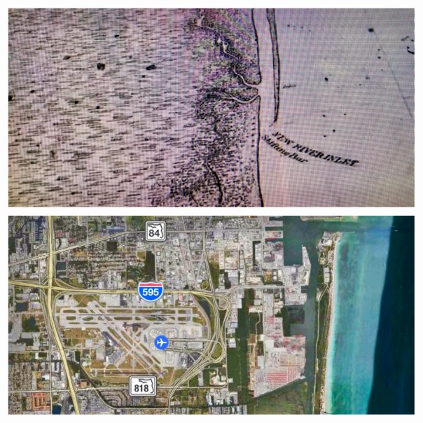
Construction to channelize the Hillsboro River and the Miami River had first begun in 1910. The New River, in 1906. It wasn’t just the most southern coastline that was wet either, apparently the region from the Jupiter Inlet to the Hillsboro Inlet was once so marshy people canoed between the two- and out into the Everglades- regularly. That was until drainage lowered the water table six feet! Crazy isn’t it!

“Everglades eastern flow was directed towards numerous natural outlets piercing the Atlantic Coastal Ridge, specifically Cypress Creek, (region of Hillsboro River JTL) Middle River, New River, Snake River, Arch Creek, Little River, and the Miami River.” These flows eventually made it to the Atlantic Ocean and  Biscayne Bay.” Pg 262, Landscapes & Hydrology of the Predrainage Everglades, 2011. 

It is strange to think that there are no natural flows through these once cypress forests and rivers, but rather a channelized construction of canals, pumps, and structures kept in place by the South Florida Water Management District.

We forget that the Everglades’ waters, beginning in Lake Okeechobee, once seeped through, on and off, around today’s Pompano Beach; Ft Lauderdale to Miami; and even at South Miami to about Leisure City. Today ADRIFT would only make it to Miami.

  1. 1850s undeveloped South Florida: Cypress Strands, the Peat Transverse Glades; and the Marl Transverse Glades were once natural seepage areas from the Everglades. Landscapes and Hydrology of the Predrainage Everglades pgs. 49, 48, & 266. Notice how canals were constructed to these natural outlets. (3)

2. Modern satellite image of of S. Florida, note areas that once flowed through near Pompano (Cypress Strands); Ft Lauderdale area (Peat Transverse Glades); and further south of Miami (Marl Transverse Glades). Compare image 1 &2.

3.  Earliest canals New River to Ft Lauderdale 1906; Hillsboro & Miami 1910. (Boyton for reference.) These canals led to where the water was naturally exiting the east coast.

“Hey First Mate!”

“Captain!”

“Get your head our of that book and look around!”

“Holy cow!” I screamed. It looked like we were going to be swallowed up by the wake of a cargo ship!


4. Near Ft Lauderdale’s Port Everglades

5. Condos along the ICW near Ft Lauderdale

6. North area of Biscayne Bay, Broad Causeway Drawbridge at Bay Harbor

I was speechless. We had entered Ft Lauderdale. The modern Transverse Peat Glades! I watched in total amazement.

“Come up on to the helm,” Ed yelled. “We’re in Biscayne Bay almost to Miami.”

I put my book aside and crawled up the ladder. Even though I despise over development , it was very exciting. Huge ships went by and multi million dollar boats were docked everywhere.

“I think this is near the area of  the recent fish kill.” I said. I showed Ed my phone pointing to the area between Highway 934 and 1-95. “The bay has polluted stormwater runoff problems and also it doesn’t get all the fresh water it historically received because we have cut off its flow connection of the cypress, peat and marl transverse glades.”

Ed looked at me through his sunglasses. “You read too much. Just enjoy!”

7. Further south in Biscayne Bay

8. Port of Miami

9. Ed smiling

10. Miami shoreline near Miami River/Maimi Canal outlet

11. Some wildlife! Yeah! Cormorants!

“Wow. This is amazing I said. My book was put away under the cushions.

“Where are we going to park? Make sure we don’t damage any seagrass.”

Ed rolled his eyes. “Not “park,” “anchor!”

We made our way just southeast of the Magic City and Rickenbacker Causeway. Remarkably, we anchored without a blip on a sandy/muddy bottom.

ADRIFT relaxed and found her direction in the tropical breezes. The whole thing was rather otherworldly. “God I love South Florida,” I thought,” even with all its water and drainage issues, she’s beautiful!”

12. A homemade dinner on the ship!

13. The Magic City arises…as night falls.

The Dramatic Shifting Sands of Ft Lauderdale, SLR/IRL

FullSizeRender 4
Comparison of 1883 historic map and Google Earth image 2017, Ft Lauderdale’s New River Inlet

Today I am sharing two creations of my brother, Todd Thurlow. Entitled “Ft Lauderdale House of Refuge/Life Saving Station,” and “Short Version,”they were originally for my mother, Sandra Henderson Thurlow and Timothy Dring’s “Image of America, U.S. Life Savings Service” book presentation at the Elliott Museum.

For me, Todd’s videos are mind-boggling as they bear witness to how much and how fast we humans can change the  environment. Like an army of ants, we organize; we build; we destroy; we create…

By comparing and contrasting Google Earth maps of today with historic maps from 1883, 1887, and 1935, Todd’s “time capsule flight,” takes us through time and space to see the shifting sands of the multiple New River Inlets; Lake Mabel that morphed into Port Everglades; remnants of the forgotten Middle River that spread and contracted into new canals and developments; and of course, for mom, House of Refuge #4, that once rested north of a New River Inlet that today we can see is completely filled in, while beach-goers relax in reclining chairs like nothing ever happened!

Maybe one day we humans can use all this energy and ability to really fix our waters that have been destroyed during all this construction? Wouldn’t that be a dramatic video?

In closing, in the early 1900s, the New River… that was believed by the Seminoles to once be an underground river that collapsed and the Great Spirit revealed during an earthquake… was selected by modern-day humans as the “natural channel” to connect two of the largest drainage canals from Lake Okeechobee to the Atlantic Coast, the North New River/South New River, and the Miami.

Please watch and enjoy Todd’s videos below!

Long Version with old New River Inlet:

(Link to video: https://www.youtube.com/watch?v=Ge1bCV5Tz5Q)

Short Version:

(Link to video: https://www.youtube.com/watch?v=oYWga93XL3w)

f10595-gif

1936 historic write-up, Francis H. Miner,  Federal Writer’s Project Ft Lauderdale, https://www.broward.org/library/bienes/lii10210.htm

Click for enlarged images:

To contact Todd: http://www.thurlowpa.com and you can access all of Todd’s videos here: http://maps.thethurlows.com.

The New River, A Personal Story, SLR/IRL

img_4749
Ed and I along the New River, 2017

The best way to learn to is to live-it.

This weekend a series of coincidences allowed me to personalize and learn the story of Ft Lauderdale’s New River, a neighbor in the water system of the Everglades and the St Lucie River/Indian River Lagoon. It is good to know about your neighbors, as you know, we are all in this water quandary together.

So my husband’s friend Dr Juan Savelli organized an evening at the Broward Center for the Performing Arts. We went to see the former lead singer of Men at Work, Colin Hay. After dinner along Los Olas, we walked across the street to the show.

And there I saw her, the river. Seawalled and controlled, no longer able to freely form a “new river” what made her reputation as told by some of the state’s earliest surveyors; her brown waters were no longer clear and teaming with wildlife as noted in some of the earliest accounts by pioneers and Seminoles; the river had been connected to canals and drainage waters of Lake Okeechobee long ago; nonetheless, she certainly remained beautiful, staring back at me with the city lights of mankind, her lion-tamer, shining behind her.

I stared at the water daydreaming, putting my day of coincidences or “serendipity,” as my mother calls it, together. I had spent the day reading UM student Zach Cosner’s incredible thesis paper, and one part came to mind:

“The trustees of the Internal Improvement Fund… would use this money to build five major canals-the North New River, South New River, Miami, Hillsboro, and Caloosahatchee, all connecting from the southern portion of Lake Okeechobee to the Atlantic Ocean…these canals reached completion towards the end of the 1910s…

Also this day I had visited my neighbor,  Mrs Kelso, who was amazingly celebrating  her 107 birthday! Remarkable. “Sharp as tack,” as they say. Half way through our conversation I asked,”So you were born in…”

“1910” she replied smiling…

fullsizerender-4
Mrs Kelso my neighbor turned 107 today! The New River Canal was completed around 1910, the year of Mrs Kelso’s birth.

“Wow,” I thought to myself, looking at the river. “Mrs Kelso is exactly as old as some of these first Florida Canals! Impressive.”

“Jacqui!” my friends called. “Let’s go! ”

I tuned and at looked at my friends. I turned and looked at the river…”

“Can I get a picture?” I asked.

Ed and I posed.

A flash in time of a river and a story. Hopefully a story that in the future will consist of men and women even more diligently at work for the New River’s complete and full restoration, and that of the entire Everglades system.

Map-of-Canals-1924-St-Archives 2
Canals complete towards end of 1910s, Florida Archives.
img_0413-2
Spanish Land Grant map New River, Florida Memory Project
f10595-gif
1932 canal map. Ray Winkelman, Broward Co.

History

The New River was one of the earliest rivers to be connected to Lake Okeechobee. Highway 27 runs parallel to the canal all the way from the lake to 175. The North Fork of the New  River is attached to the New River Canal; and the South Fork of the New River is connected to the Miami Canal. (see above map) Today it is almost impossible to see the connection of the canals to the river amongst the tangle of development surrounding the river.

IMG_0409.PNG
Google map New River and Ft Lauderdale, canals attach near I95
IMG_0410.PNG
closeup
IMG_0411.PNG
West of I95
IMG_0412.PNG
Overview Lake O is just north…

.

img_4752

Video Men at Work Who Could it Be Now> (https://www.youtube.com/watch?v=SECVGN4Bsgg)

Wikipedia History of New River:

According to a legend attributed in 1940 to the Seminoles by writers working in the Florida Writers’ Program of the Work Projects Administration, New River had appeared suddenly after a night of strong winds, loud noises, and shaking ground, resulting in the Seminoles calling the river Himmarshee, meaning “new water”. The report of the Writers’ Project attributed the noise and shaking to an earthquake which collapsed the roof of an underground river.[1] Folk historian Lawrence Will relates that the Seminole name for the river was Coontie-Hatchee, for the coontie (Zamia integrifolia) that grew along the river, and that the chamber of commerce tried to change the name of the river to Himmarshee-Hatchee during the Florida land boom of the 1920s.

The English name is derived from early explorer’s maps. The mouth of the river was noted for its tendency to continuously change its entry point into the Atlantic Ocean through the shifting sand of the barrier island. Each time the coast was surveyed and charted the entry point would have shifted. So the location of the mouth would not be on any previous maps, and from off the coast would appear as if it had just developed. With each charting, the location would be recorded with the notation “new river”. Since that was the name used on the maps, that was the name by which the first settlers came to know it, so the name stayed.

From Broward County.org, “The River’s Decline”

Today the New River is in desperate need of repair. This once crystalline waterway has deteriorated under the strains of immense growth. Water quality has been adversely affected from debris, sedimentation, storm water runoff, and other pollutants. Inappropriate land uses near the water have also contributed to the decline of the River and its tributaries. This degradation of water quality and habitat represent a negative impact on the environment, health, and economy of the Broward County metropolitan area.

Video New River, Florida Memory “Then and Now:”

https://www.floridamemory.com/exhibits/floridamaps/ft_lauderdale.php

History New River, Broward Co.

Click to access pub_newriver_1.pdf

New River FDEP: http://www.dep.state.fl.us/southeast/ecosum/ecosums/N_new_river.pdf

Why Aren’t the Historic Canals Draining too? Miami/New River …SLR/IRL

Map of Canals 1924 Florida Archives.
Map of earliest canals built in 1911. The SL Canal was built in 1915-1923  and was then widened and deepened in the 1940s. Florida Archives.
Close up
Close up of SFWMD map today showing S-structures south of LO. See rim of lake.
South Florida and WCAs
South Florida has many “S” structures and S-333 is one of a few furthest south, south of WCA 3, allowing water to enter the Everglades and other areas.

Today’s blog will feature a common sense question. The question is basically why isn’t the dumping into the St Lucie River/Indian River Lagoon being alleviated by the large canals south of Lake Okeechobee, specifically the Miami and New River? Those two rivers were used before for drainage before our St Lucie canal  was even constructed. The Miami River naturally had rapids before they were blown up with dynamite…Mother Nature had her way of dealing with the some of the spillover waters of Lake Okeechobee. Why aren’t we following that model?

I think a recent exchange between my brother Todd and Dr Gary Goforth gives insight into this question.  I learned from it and the conversation is not yet over, thus I am posting it today.

By the way, just in case you don’t know, “S” means “structure” for water releases…. There are hundreds of structures that allow water to drain Lake Okeechobee and thus South Florida. The SFWMD deals with the structures south of the lake and the ACOE deals with the larger structures that go east west to the our northern estuaries.

Here we go:

TODD: http://www.thurlowpa.com/news.htm
“Right now…  I am looking at the status map asking: “Why are the WCAs rising while very little water, if any, seems to go out to the New River (S-34) and the Miami River (S-31), which are historical tributaries of the Everglades (they even had rapids!) ?— all while we are getting dumped on because the Water Conservation Areas (WCAs) are over schedule?”

Recently, S-34 flowing into the New River was at 0 cfs. Now I see that it is at 233 cfs. A drop in the bucket compared to the 7523 cfs that has been hitting the St. Lucie for days.

That S-333 doesn’t seem to flow to the Park but instead to the Miami River also. (Someone correct me if I am wrong.) It was at 0 cfs on the 4th and is now at 1200 cfs. Even if that water isn’t going to the Park, at least it is going south and not east/west – but why the wait? The system is more complex than we will ever understand but the more we understand the better. Thank you, Gary, Mark Perry and others for keeping everyone informed.


DR GOFORTH:http://garygoforth.net
Todd – you’re absolutely correct – the New River and Miami Canal were historical tributaries of the Everglades.

“Why are the WCAs rising while very little water, if any, seems to go out to the New River (S-34) and the Miami River (S-31)?”

The short answer is that flood protection for the suburbs of Ft. Lauderdale and Miami takes precedence over conveyance of floodwaters from the water conservation areas. The intervening canals are operated to provide flood protection to the urban areas between S-31/S-34 and the tidal structures (S-26/ – similar to S-80 in the C-44). When heavy rains occur in the suburbs, the canal capacity is primarily devoted to moving the stormwater out of the basin. After the storm events and water levels in the canals subside, S-31 and S-34 can be opened to move so-called “regulatory releases” out of the water conservation areas. This is similar (although not exact) to how S-308/S-80 and the C-44 Canal is operated – flood protection of the local basin takes precedence over Lake releases.

“why the wait?”

Opening S-333 allows water from WCA-3 to move into the Tamiami Canal (aka L-29 Canal); the one-mile bridge along Tamimi Trail allows water from the Tamiami Canal to enter Northeast Shark River Slough (see the map). S-333 couldn’t open without special authorization from the Corps to allow the water level in L-29 Canal to rise, which Gov. Scott requested in his letter last week, and the corps granted this week.

Gary Goforth
Gary Goforth S-333.


Interesting  to think about…maybe there is more to explore here….

__________________________________________________

Miami River history/rapids: http://www.miamirivercommission.org/river3.htm

Undated SFWMD S-333 regulation schedule info:http://www.sfwmd.gov/portal/page/portal/xrepository/sfwmd_repository_pdf/wca_schedules_082604.pdf

Contact the SFWMD should you wish to get a Facility and Infrastructure Location Index Map: (561) 682-6262. The person at this number should be able to direct you.


Charles Pierce’s Account of the Great Rain of 1884, and How it Relates to the Indian River Lagoon

"End of he Rainbow," South Florida. (Photo by John Whiticar, 2013.)
“End of the Rainbow,” South Florida. (Photo by John Whiticar, 2013.)

As we approach hurricane season, we must prepare for rain. Florida is more like Africa than the rest of the county in that there are really only two seasons: dry and rainy. “Officially,” rainy season runs from June 1st to November 30th, and dry season is from December 1st through the end of May.

One of the most interesting accounts I’ve ever read of a “great south Florida rain” was published in 1886 by pioneer  Charles Pierce, member the famous Hannibal Pierce family, to which our illustrious Indian Riverkeeper, Mr Marty Baum belongs. We along the St Lucie/Indian River Lagoon are part of the south Florida great rain system and there are reoccurring themes whether here or farther south, as  l think you’ll see as I share the story.

Charles Pierce is most well known for his book “Pioneer Life in Southeast Florida” written about the years 1870 through 1894, and published by Miami’s University Press in 1970. It is a five star classic. According to a write up on the book, during this era of Florida history  around 724 people were living between Stuart and Miami.

My mother, historian  Sandra Thurlow, shared an excerpt that Charles Pierce wrote for the Broward Legacy in 1886, as he was living and overseeing  the Biscayne House of Refuge at the time.

According to Pierce:

“In October of 1884 occurred the greatest and longest rainfall ever known on the east coast since its  earliest settlement. It poured down for eight days and nights, slacking at times for a few minutes, but never stoping; then came down harder if that were possible. The whole southern part of the state was inundated…

On the eighth day the rain stopped and the next day came in bright and clear, and the sun shone brightly on a rain-soaked Florida…

I was on the east porch looking out to sea…looking up the coast to the northward, I caught the glint of something white about four miles away. At first, I thought it was a sea gull, then it looked like striking fish. I was not certain which it was, so I went for the old long spyglass to get a close up view  of the scintillating white. What the spyglass revealed surprised me. The flickering white I had seen was now clearly shown to be whitecaps or breaking seas at the head of a dark body of water rushing down the coast….a mass of dark water some hundred feet in width rushing along to the south and with breaking seas over running the blue water in front.

It was a strange sight and at first we all wondered where it came from. My father Hannibal solved they mystery when he said, ‘It is fresh water from the New River Inlet.’ Could that be possible? It was fourteen miles away but there was no other solution to the phenomenon.

What a mighty volume of water must be coming out of the inlet and with tremendous velocity enough to overcome the resistance of wind and sea for so many miles. By night of that day the entire ocean in sight of the Station was covered with dark coffee-colored freshwater from the New River. Not a bit of blue water to be seen in any direction. Biscayne Bay was fresh for nearly a month after the week of rain.”

Incredible. So even before humankind diked and channelized the entirety of south Florida, when it  rained heavily, the black wave of fresh water pushed forth through the south eastern inlets to the ocean; it did not just “go south.” We see a similar but not as intense phenomenon today, although drainage has been modified, when a heavy rain gushes through the  St Lucie Inlet, Ft Pierce or Jupiter Inlets.  In any case,  when one hears a story such as Mr Pierce’s it makes one wonder, with all that water,  during a really “great rain” a rain that comes only once in a few hundred years, will our manmade structures hold?

We all know the Army Corp of Engineers, along with support from the South Florida Water Management District, is working diligently to harden the dike around Lake Okeechobee, but it seems that a third outlet, a flow way south, from the lake to the Everglades surely would alleviate some of that natural pressure, the pressure Charlie Pierce describes as  a
“tremendous velocity…”

If he were alive today, I wonder what Mr Charles Pierce would think?

_____________________________________________________________

Lake Worth Pioneer Association, (Charlie Pierce family): (http://www.lwpa.org/pioneer_hannibal_dillingham_pierce.html)